HAL Id: hal-00298322
https://hal.archives-ouvertes.fr/hal-00298322
Submitted on 23 Feb 2007
HAL is a multi-disciplinary open access
archive for the deposit and dissemination of
sci-entific research documents, whether they are
pub-lished or not. The documents may come from
teaching and research institutions in France or
abroad, or from public or private research centers.
L’archive ouverte pluridisciplinaire HAL, est
destinée au dépôt et à la diffusion de documents
scientifiques de niveau recherche, publiés ou non,
émanant des établissements d’enseignement et de
recherche français ou étrangers, des laboratoires
publics ou privés.
Current
J. R. E. Lutjeharms
To cite this version:
J. R. E. Lutjeharms. Three decades of research on the greater Agulhas Current. Ocean Science,
European Geosciences Union, 2007, 3 (1), pp.129-147. �hal-00298322�
www.ocean-sci.net/3/129/2007/
© Author(s) 2007. This work is licensed under a Creative Commons License.
Ocean Science
Three decades of research on the greater Agulhas Current
J. R. E. Lutjeharms
Department of Oceanography, University of Cape Town, 7700 Rondebosch, South Africa Received: 8 June 2006 – Published in Ocean Sci. Discuss.: 25 July 2006
Revised: 22 January 2007 – Accepted: 22 January 2007 – Published: 23 February 2007
Abstract. The greater Agulhas Current has been shown to be a key link in the global thermohaline circulation and an in-creased understanding of this current system is therefore of more than just local interest. Knowledge on the Agulhas Cur-rent system has in fact increased enormously over the past 30 years. This review covers some aspects of what has been learnt on the northern and the southern parts of the Agulhas Current proper and their influence on the waters and circu-lation of the adjoining continental shelf. It also discusses the Natal Pulse and new information that has been gained on how it is triggered and what influence it has. It deals with the Agulhas retroflection, the shedding of Agulhas rings and the movement and characteristics of these rings that contributes to the meridional overturning circulation of the global ocean. The Agulhas Return Current forms part of the final outflow of the system and current knowledge on that current is ap-praised. The sources of the Agulhas Current have been a con-troversial subject for many years and this dispute continues. This is described and discussed, based on what information has been gained from research over the past three decades. Building on what is currently known, some suggestions are given on the most important remaining knowledge gaps and how these could most efficaciously be filled.
1 Introduction
It is of some historical interest that the Agulhas Current was one of the first western boundary currents described scien-tifically in some detail (Rennell, 1832). The reason for this is not difficult to understand. This strong, southward-setting current constituted a major obstruction to commercial vessels sailing from Europe to the Indies at the time. Having a strong maritime interest, the Dutch in particular gave the current a
Correspondence to: J. R. E. Lutjeharms
lot of research attention (e.g. Van Gogh, 1857) even to the extent of investigating its influence on the overlying atmo-sphere and thus on local storms (Van Gogh, 1878), generally considered a very modern research topic. This early research, largely based on ships’ drift and measurements of sea surface temperatures, lead to an excellent, prescient portrayal of an Agulhas retroflection (see Lutjeharms et al., 1992). Regret-tably, most of this fundamental knowledge was subsequently lost.
The next spurt in research on the Agulhas Current and the circulation of the South-West Indian Ocean as a whole oc-curred in the 1930s, carried out almost entirely by British and German scientists (see e.g. Lutjeharms and Kortum, 2003). The big steps forward in understanding brought about par-ticularly by German research was subsequently also lost to science (Lutjeharms and Kortum, 2006) and when the Inter-national Indian Ocean Expedition of the 1960 came about (W¨ust, 1960) it started as if on a blank sheet. One of the first and most important directed investigations on the Agulhas Current as a whole was conducted only in 1969 as the “Com-bined Agulhas Cruise” (Bang, 1970a). This led to a whole number of new concepts on the Agulhas Current (e.g. Bang, 1970b), the rediscovery of the retroflection (and the creation of the term; viz. Lutjeharms, 1980; Lutjeharms et al., 1992) and some thoughts on the possibility of ring shedding at the termination of the current. This benchmark in knowledge in the 1970s is conceptually portrayed in Fig. 1.
A number of key elements of the Agulhas Current system are immediately apparent in Fig. 1. First, the Agulhas Cur-rent is seen to be fed largely by water coming from its pre-sumed precursor in the Mozambique Channel, the Mozam-bique Current. This water is joined by that of another broad tributary from east of Madagascar, the East Madagascar Cur-rent, to form the Agulhas Current that was believed to be
thus fully constituted at about 30◦S where some water from
a “Return Agulhas Current” contributed the last elements to the flow. The Agulhas Current water is then portrayed as
Fig. 1. The general circulation of the South West Indian Ocean as it was understood in the 1960s (Bang, 1973b). Particularly notewor-thy is the detail given for the assumed circulation south of Africa and along its west coast. The contrast between these regions and others in the portrayal is directly due to the fact that recent research cruises had investigated these former regions, but not elsewhere.
flowing poleward along the shelf edge of southern Africa, turning back on itself south of Africa and thus returning most of its water eastward. Not much succeeds in proceeding
fur-ther than about 35◦E, most returning in the aforementioned
“Return Agulhas Current”. At the retroflection of the current there is evidence for some large vortices. The Subtropical Convergence is depicted as forming the southern boundary to the Agulhas Current system. Along the west coast of south-ern Africa a few coastal upwelling cells are evident. Their convoluted fronts are shown in some detail. This specific de-tail is the direct result of a particular and long lasting interest in these features by Bang (1973).
It is immediately clear that some components of the circu-lation in the South-West Indian Ocean are also shown in con-siderable detail in Fig. 1, whereas other parts are portrayed in only the vaguest ways. This was a direct consequence of the data available to Bang at the time. Much work had been done in the Benguela upwelling area by the then Sea Fish-eries Branch and the detailed cruise on the Agulhas Current mentioned above had just taken place (Bang, 1970a). Both these systems are therefore portrayed with some confidence. By contrast, hardly any appropriate data were available for the Mozambique Channel and nothing at all for the region east of Madagascar. The flow in these regions is therefore given in only the broadest terms. This all changed with the International Indian Ocean Expedition (e.g. Wyrtki, 1971) and the subsequent rapid growth in interest in the region, both nationally in South Africa as well as internationally. One of the main components that received a lot of attention in the 1960s and 1970s was the northern Agulhas Current.
Fig. 2. The surface expression of the northern Agulhas Current from satellite thermal infrared (Lutjeharms, 2006b). The narrow, nearly linear trajectory of the current is clear. Near 30◦S, directly up-stream of Durban, there is some evidence of shear edge disturbances on the inshore edge of the current. Downstream of Port Elizabeth there are indications of the onset of meanders. This image is from the NOAA 9 satellite for 26 August 1985.
2 Agulhas Current
With the advent of satellite remote sensing it was soon dis-covered (Harris et al., 1978; Lutjeharms, 1981) that the ulhas Current can be considered to consist of a northern Ag-ulhas Current and a southern AgAg-ulhas Current. These two parts have distinctly different trajectorial behaviours.
2.1 Northern Agulhas Current
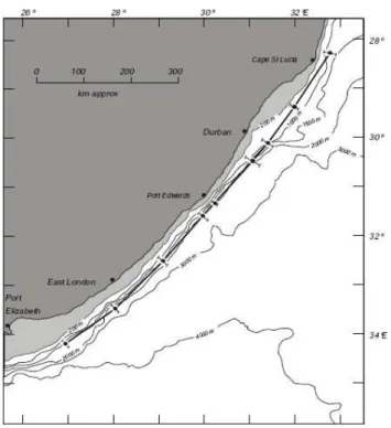
The northern Agulhas Current has been shown to be quite re-markable as a western boundary current for its invariant path. This is evident in Fig. 2. The current core can be seen to fol-low the shelf edge very closely. This can also be seen very clearly in Fig. 3. By comparison other western boundary cur-rents such as the Gulf Stream and the Kuroshio exhibit sub-stantial sideways meanders. The path given in Fig. 3 is based on a large number of vertical hydrographic sections across
the current. The intersection of the 10◦C isotherm with the
200 m isobath was taken as representative of the location of the core of the current (Gr¨undlingh, 1983). On about 20% of the sections there was no evidence of the Agulhas Cur-rent whatsoever, even up to a distance of 200 km offshore, suggesting the presence of an unusual, intermittent meander. About this more later.
The stability of the northern Agulhas Current has subse-quently been studied and explained as being a consequence of a very steep continental slope (De Ruijter et al., 1999). The only place along its path where this does not hold is at the Natal Bight, a wider part of the shelf in a coastal off-set north of Durban (see Fig. 3). The different behaviour of
the current here is evident in Fig. 2 which shows that shear edge features are being formed here whereas they are absent along the rest of the current. This may also be due to the wider shelf, allowing shear edge eddies to develop larger lat-eral expressions here.
The kinematic nature of this part of the current was stud-ied in detail from Durban in the 1970s (e.g. Pearce, 1977) when the South African CSIR maintained an active research institute there, with a small research vessel, the “Meiring Naud´e” (Gr¨undlingh, 1988). It was shown that the Agul-has Current consisted of three primary zones, a sharp, in-shore, thermal frontal zone, the core of the current and a more disperse offshore front. The temperatures were greater
than 22◦C, the speeds 1.3±0.3 m/s and the volume flux was
estimated at 72 Sv (Sv=106m3/s) over the full depth of the current (Gr¨undlingh, 1980). These investigations established the core parameters for the current in a relatively reliable fashion for the first time. These pioneering South African efforts were terminated in the 1980s (Lutjeharms and Thom-son, 1993), but fortunately followed in the 1990s by the placement of current meter moorings in the current by British
oceanographers (Beal and Bryden, 1999). The
measure-ments from this project gave a very accurate, average value of the volume transport of 69.7±4.3 Sv, the best to date.
Even more important, their precise measurements allowed the discovery of an Agulhas Undercurrent (Beal and Bryden, 1997) that had only been hypothesised before. This under-current was shown to have a volume flux of 4.2 Sv equator-ward and to consist largely of modified Red Sea Water. The depth of the current was unexpectedly variable. By compar-ing three velocity sections at the same latitude, Donohue et al. (2000) were able to show that on occasion the current ex-tends to the bottom whereas on other occasions its vertical penetration was only to a depth of 2300 m. The temporal variability in these depth changes and the driving processes involved are not as yet known. However, the surface char-acteristics of the northern Agulhas Current were firmly es-tablished by the 1980s and the subsurface variables by the 2000s.
Of more local interest was the influence of the Agul-has Current on the circulation on the adjacent continental shelf and in particular on effluent dispersal (e.g. Gr¨undlingh, 1974). A pioneering study of bottom sediments on this shelf and tell-tale morphological structures (Flemming, 1980) showed that the movement on the narrow shelf was parallel to the current – not unexpectedly – except in regions where the shelf is wide. Here the sediment movement is indetermi-nate. In general, the circulation on the aforementioned Natal Bight has been thought of as consisting of cyclonic eddies (e.g. Schumann, 1982; Malan and Schumann, 1979). Not so intuitively expected was the finding that the current north of the Natal Bight is dominated by movement over the con-tinental shelffto the north east (Flemming and Hay, 1988). This meant that the location along this coast where the Ag-ulhas Current can be thought of as starting was not known
Fig. 3. Location of the core of the northern Agulhas Current (after Gr¨undlingh, 1983). Error bars show the standard deviation at each section, superimposed on the bathymetry. The wider part of the continental shelf between Durban and Cape St. Lucia constitutes the Natal Bight.
and this ignorance has remained. The northern Agulhas Cur-rent has been shown to have some other unusual influences on the shelf, by forcing a distinctive upwelling cell near Cape St. Lucia.
This cape lies at the northern edge of the Natal Bight (Fig. 4). Unusual concentrations of low temperature, high chlorophyll and high nutrients were observed here (e.g. Carter and Schleyer, 1988; Carter and d’Aubrey, 1988) as part of investigations to establish baseline values before a large industrial outfall was constructed in the 1970s. These anomalous values for hydrographic variables were explained (Lutjeharms et al., 1989a) when the availability of satellite remote sensing made it evident that an upwelling cell was located off St. Lucia more or less permanently. A subse-quent research cruise that covered the whole Natal Bight for the first time in 1989 (Lutjeharms et al., 2000a; Meyer et al., 2002) showed unambiguously that this active upwelling cell is a “point” source of nutrients for the shelf of the Na-tal Bight as a whole and has the highest primary productivity for the whole region (Fig. 4). Analyses of the winds in the region have exhibited no statistical correlation between this upwelling and wind direction, indicating that this coastal up-welling is not wind induced. Theoretical studies (Gill and Schumann, 1979) have indicated that when an intense, jet-like current – such as the Agulhas Current – moves from a narrow shelf to a wider shelf, upwelling inshore of the
Fig. 4. The distribution of phosphate over the Natal Bight (after Meyer et al., 2002). That area shallower than 200 m and not cov-ered by phosphate values above 2 µmol/l is shaded to highlight the unusual width of the shelf here. The presence of a distinct and ac-tive upwelling cell near St. Lucia is evident. The influence of this nutrient-rich water did not extend farther than half the length of the bight on this occasion. Dots denote the location of hydrographic stations for a quasi-synoptic cruise carried out in 1989.
current will be induced. The upwelling at St. Lucia is there-fore most probably dynamically driven by the adjacent cur-rent as a result of the appropriate shelf morphology. Local observations, particularly those taken in the 1970s, have also established other regional circulation phenomena, such as a persistent eddy off Durban.
As can be seen in Fig. 3, the shallow region of the Natal Bight ends abruptly at Durban. The Agulhas Current follows the shelf edge of the Natal Bight closely (Pearce et al., 1978), but overshoots at the shelf offset at Durban. A tight lee eddy has often been observed here (Anderson et al., 1988) and is believed to be driven by the passing current. It is clearly evi-dent in most, more modern, hydrographic observations in the region as well (e.g. Meyer et al., 2002). The discovery of this feature makes an understanding of the movement of some oil spills here much easier (Gr¨undlingh and Pearce, 1990). Mesoscale circulatory features such as these are much more prevalent on the landward side of the southern Agulhas Cur-rent.
2.2 Southern Agulhas Current
Downstream of Port Elizabeth the continental shelf widens considerably to form the broad expanse of the Agulhas Bank south of Africa (viz. Fig. 18). Along the eastern edge of this bank the Agulhas Current starts to develop meanders (Har-ris et al., 1978) very similar to those found on the compara-ble Gulf Stream. These meanders have been shown to grow downstream (Lutjeharms et al., 1989b) and have attendant cyclonic eddies and warm water plumes. The latter may ex-tend over large parts of the bank even influencing the wa-ters and the biota in bays on the coastline (e.g. Goshen and Schumann, 1988, 1994). The distribution of shear edge ed-dies seems to be concentrated in the eastward facing bight of the Agulhas Bank and this geographical predominance has subsequently been fairly well simulated by numerical mod-els (Lutjeharms et al., 2003a). A substantial body of knowl-edge has therefore been built up concerning the shear knowl-edge features of the southern Agulhas Current. Their influence on Agulhas Bank waters has however as yet not been quantified. Plumes from the Agulhas Current have also been implicated in inter-ocean exchange.
Once past the most southern tip of the Agulhas Bank the southern Agulhas Current proceeds into the South Atlantic as a free inertial jet, but still generates plumes of warm water at its northern border (Lutjeharms et al., 1996). These Agulhas filaments have been observed to be only about 50 m deep, but carry anomalous warm, salty water into the Atlantic Ocean. Because of their limited vertical extent the heat in these fil-aments is soon lost to the atmosphere, this being a region of large ocean to atmosphere heat flux (e.g. Walker and Mey, 1988; Rouault and Lutjeharms, 2000). The inter-ocean heat flux by Agulhas filaments has therefore been considered to be minimal. The inter-ocean salt flux is by contrast not lost, but constitutes only about 10% of the salt flux achieved by other processes.
Agulhas filaments have been shown to follow the western shelf edge of the Agulhas Bank quite closely, but their tra-jectories are often disturbed by a cyclonic eddy prevalent on the western side of the bank (Penven et al., 2001). Modelling has suggested that this lee eddy is driven by the passing Ag-ulhas Current, fed cyclonic vorticity from passing shear edge eddies and that it eventually escapes into the South Atlantic (Lutjeharms et al., 2003b) to join a plethora of eddies and rings in the Cape Basin west of Cape Town. The location and persistence of this lee eddy may interfere with the shelf edge jet (Boyd et al., 1992) supposedly present here most of the time.
The warm waters of the Agulhas Current have for a long time been considered to play an important role in the weather and the climate of the southern African subcontinent. This was quantified for the first time by Walker (1990) who has been able to show that the sea surface temperatures of the Agulhas Current are directly linked to summer rainfall over South Africa. Work of this nature has continued (e.g. Crimp
et al., 1998; Reason, 2001) and is being extended and re-fined. Other studies have tried to investigate the influence of sea-air interaction on extreme weather systems (e.g. Walker and Lindesay, 1989). Studies dedicated to the influence of the southern Agulhas Current have shown (Rouault et al., 2002) that air travelling over the current for a long time and gaining both heat and moisture may considerably enhance the intensity of inland storms. This type of sea-air exchange had long been expected since the formation of lines of cu-mulus clouds over the current had frequently been seen in satellite images (Lutjeharms et al., 1986a). To observe the in-fluence of the Agulhas Current on the overlying atmosphere more precisely, a focussed programme of investigations was started in the 1990s to measure the fluxes in situ (Rouault and Lutjeharms, 1994). These demonstrated that there was substantial moisture uptake by the atmosphere over the cur-rent (Lee-Thorp et al., 1999) with the marine boundary layer affected to a height that could indeed induce cumulus cloud formation (Lee-Thorp et al., 1998). In this way the influence of the Agulhas Current on the air passing over it has been fairly well quantified in the 1990s.
Apart from the meandering and the production of shelf edge features, the southern Agulhas Current has been shown to be very similar to the northern Agulhas Current. Its vol-ume flux has first been estimated to be 125 Sv (Jacobs and Georgi, 1977) implying that the volume flux increases by about 6 Sv for every 100 km travelling downstream in the
current. Its surface temperatures are 23–26◦C and its
sur-face salinity 35.4 (Gordon et al., 1987). Sursur-face speeds may be in excess of 2 m/s. In one other aspect it is also similar to the northern Agulhas Current, namely coastal upwelling driven by the Agulhas Current.
It has been shown that at the most upstream point of the Agulhas Bank, near Port Elizabeth (viz. Fig. 3), there is per-sistent upwelling. Here, at Port Alfred, the southern Agulhas Current experiences roughly the same shelf configuration as does its northern counterpart at St. Lucia, namely a narrow shelf that increases in width downstream. The surface ex-pression of the Port Alfred upwelling cell seems to be influ-enced by the wind (Rouault et al., 1995) whereas the subsur-face inflow of cold water has been inferred as being perennial (Lutjeharms et al., 2000b). The surface expression as shown by temperatures at the sea surface is given in Fig. 5. From here water has been shown to move over the bottom of the rest of the Agulhas Bank (Lutjeharms and Meyer, 2006) in the form of a cold ridge that roughly follows the 100 m iso-bath (Swart and Largier, 1987). This cold water inflow has been surmised to be the mechanism for the cooling of water over the Agulhas Bank from below in summer (Lutjeharms, 1998) as it is heated by insolation from above. This inflow from an upwelling cell also leads to an anomalous insertion of nutrients (Lutjeharms et al., 1996) that is not normally expected on a shelf of this kind, making it potentially more biologically productive than elsewhere.
Fig. 5. Outlines of cold, upwelled water inshore of the Agulhas Current at Port Alfred (after Lutjeharms et al., 2000b). These out-lines were for the months of January to May 1991 and show that the geographic extent of the upwelling may be quite variable, but that the centre seems to remain at Port Alfred.
Normal, wind-driven coastal upwelling has also been ob-served at headlands of the coastline (Schumann et al., 1982) particularly on the western side of the Agulhas Bank (Boyd et al., 1985) which can in some ways be considered part of the Benguela upwelling regime (Lutjeharms and Meeuwis, 1987). Since the winds here are predominantly in an east-erly or westeast-erly direction, wind-driven upwelling could be expected along this zonal coastline. The reaction of waters at the coast to strong winds from the east has been shown to be very rapid (e.g. Beckley, 1983; Lutjeharms, 1998) and can have an important influence on the ecology of the adjacent coastline (Schumann et al., 1988).
2.3 Natal Pulse
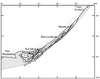
As mentioned above, there had been indications in the 1970s that the Agulhas Current experiences an intermittent mean-der of substantial dimensions. Gr¨undlingh (1979) was able to capture a meander in the Agulhas Current with hydrographic observations. Satellite remote sensing subsequently made it possible to study the trajectory of the current in more de-tail and over a longer period (e.g. Lutjeharms and Roberts, 1988) and it was discovered that singular meanders on the current are an inherent part of its dynamics, that these mean-ders move downstream at a more-or-less constant speed and that they grow during this movement (Fig. 6). Since their origin is the Natal Bight, they have been dubbed the Natal Pulses. Some evidence has been reported that similar flow disturbances may be created at the Delagoa Bight in south-ern Mozambique (Gr¨undlingh, 1992), but these have to date not been observed to move far pole-wards. So what is it that makes the Natal Bight so special that it is the exclusive ges-tation region for Natal Pulses?
20º 30º E 30º 35º S 08-06-79 14-06-79 23-06-79 25-06-79 29-06-79 05-07-79 27-07-79 Port Shepstone East London Port Elizabeth Cape St Blaize
Fig. 6. Sequential outlines of the landward border of the Agulhas Current for the dates shown. This series shows the downstream progression and growth of a Natal Pulse. This information is from satellite infrared imagery (after Lutjeharms and Roberts, 1988).
As mentioned before (viz. Fig. 3), the slope of the shelf along which the northern Agulhas Current flows is quite steep, with the exception of that off the Natal Bight. De Rui-jter et al. (1999a) have shown that the Agulhas Current has the potential to become unstable only where the continental slope is weak, therefore the Natal Bight would be an ideal lo-cation for this to happen. However, to cross the threshold to become unstable here the Current needs to become more in-tensified or to be perturbed from its normal condition. Such a perturbation could come about by the adsorption of an off-shore eddy onto the current. Schouten et al. (2002a) have elegantly shown that such adsorptions do occur and indeed do have the triggering effect previously only surmised. It has also been shown that these Natal Pulses extend throughout the depth of the Agulhas Current (Lutjeharms et al., 2001) and that they cause current reversals on the adjoining shelf (Lutjeharms and Connell, 1989).
The downstream growth of the Natal Pulse (viz. Fig. 6) may have some dramatic consequences south of Port Eliz-abeth. About 200 km south of the shelf lies the Agulhas Plateau, a relatively shallow region. The Agulhas Current has to pass through this gap, as has the Agulhas Return Cur-rent on its way east. If the Agulhas CurCur-rent is forced too far off course by a well-developed Natal Pulse, its path will in-tersect the Agulhas Plateau and it will turn back on itself, i.e. retroflect before it gets any farther, due to vorticity consider-ations. This upstream retroflection has in fact been observed (e.g. Lutjeharms and van Ballegooyen, 1988a) and has global implications to be discussed below. This has to do with the inter-ocean exchange of oceanic water masses at the Agul-has retroflection (De Ruijter et al., 1999b) that Agul-has been es-pecially studied in the 1990s.
3 Agulhas retroflection
A temperature image of the retroflection of the current is given in Fig. 7. This shows clearly how the southern Ag-ulhas Current overshoots the southern tip of the wide shelf
Fig. 7. Thermal infrared satellite image of the termination region of the Agulhas Current on 13 November 1985 obtained from in-struments on board a NOAA satellite (Lutjeharms 2006b). The red band shows the location of the southern Agulhas Current, the Ag-ulhas Return Current and the retroflection south of Africa that con-nects these two. Notice the cold water (<15◦C) to the south that constitutes the Subtropical Convergence and a wedge of such cold water moving northward on the westward side of the retroflection loop. The cold water on the west coast of southern Africa is the surface expression of wind-driven coastal upwelling.
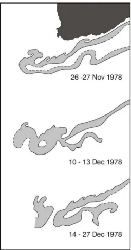
south of Africa and then retroflects to become the eastward flowing Agulhas Return Current. The width of the current does not change much during this process, nor does its depth (Gordon et al., 1987). The depth of the current at this point has been observed to be about 4000 m (Schmitz, 1996) and the average diameter of the retroflection loop 300 to 400 km (Lutjeharms and van Ballegooyen, 1988b). Speeds in this part of the current can reach 2 m/s. This configuration of the current does not stay the same, but the retroflection loop continuously progrades into the South Atlantic. At the ex-treme of each progradation the retroflection loop is short cir-cuited (Fig. 8) and a ring is occluded (Lutjeharms and Gor-don, 1987). Could the arrival of a Natal Pulse in the retroflec-tion region trigger such a ring shedding event?
Careful analysis of satellite information (Van Leeuwen et al., 2000) has shown that this is indeed the case, but that ring spawning can also occur spontaneously if a long period passes without a Natal Pulse. One might well ask what would be the effect of such a durable absence of Natal Pulses on the inter-ocean exchange south of Africa. Current thinking (e.g. Penven et al., 2006) is that the shedding of Agulhas rings would persist, but at a reduced frequency.
The first development of the concept of a true retroflection of the Agulhas Current was by Bang (1970b), but remained dormant till the late 1980s when satellite thermal imagery
made the turning back on itself of the current more clearly visible than before and the notion was revived (Lutjeharms, 1981). Proof of the ring shedding process then also became possible for the first time (Lutjeharms and van Ballegooyen, 1988b).
Why should the Agulhas Current retroflect in such a dra-matic way? A large number of investigations on the matter have been carried out (e.g. De Ruijter, 1982; De Ruijter and Boudra, 1985; Dijkstra and de Ruijter, 2001a, b). Much of this has been ably summarised by de Ruijter et al. (1999b). The answer is not yet unambiguously clear. A number of mechanisms have been considered such as inertia, the beta-effect and side-wall friction (De Ruijter, 1982). Perhaps all of these play a role – which may vary with time – but in as yet unknown proportions.
Why should such a lot of international attention have been given over the past two decades to a process far away from the main centres of oceanographic research, at the southern tip of Africa? The main reason is the inter-ocean exchange of water that takes place here (Gordon, 1985).
As will be seen in the discussion below, Agulhas rings carry vast amounts of warm, salty Indian Ocean water into the South Atlantic Ocean. It has been shown that this inter-ocean leakage forms a crucial link in the climatically crucial global, thermohaline circulation (Gordon, 1986). Based on a palaeo-climatological investigation it has even recently been demonstrated (Peeters et al., 2004) that this inter-ocean leak-age has been particularly strong at the end of each of the last five glacial periods, but that it has never been absent entirely (Rau et al., 2002). Modelling studies by Weijer et al. (1999, 2001, 2002) have in addition shown that a diminution in the exchange at the Agulhas retroflection leads inexorably to a slowing of the Atlantic Ocean’s thermohaline overturning. The importance of this process of ring shedding at the Agul-has retroflection Agul-has thus been demonstrated during the past decade as have the mechanisms that control it. The latter may have to do with the triggering of Natal Pulses and these in turn may be influenced by eddy formation in the source re-gions of the Agulhas Current (Schouten et al., 2002b). About this more in Sect. 6.
The shedding of Agulhas rings has some secondary, at-tendant processes that may be locally important. First, the cyclonic lee eddy on the western side of the Agulhas Bank (Penven et al., 2001) has been observed sometimes to de-tach from the shelf edge and to move south-westward. In this process it may intersect the Agulhas Current retroflec-tion loop (Lutjeharms et al., 2003b) and set off the forma-tion of an Agulhas ring. The frequency with which these lee cyclones are shed and if they always trigger ring spawn-ing events remains unknown. A second effect is evident in Fig. 7, namely the equatorward penetration of a wedge of cold water between a newly shed Agulhas ring and its parent retroflection. This cold water has been shown to extend to substantial depths (Lutjeharms and Fillis, 2003) and may on occasion (e.g. Shannon et al., 1989) cover a very large region
Fig. 8. A combination of outlines of the Agulhas Current for the periods shown from thermal infrared satellite imagery (after Lutje-harms and van Ballegooyen, 1988b). It shows normal progradation of the retroflection loop westwards, the occlusion of an Agulhas ring and the subsequent movement of an unattached ring into the South Atlantic Ocean.
in unusually cold water, thus potentially affecting the local weather and rainfall. This process has been evident in some models of the Agulhas Current (e.g. Boudra et al., 1989) and thus it seems to be an inherent part of the physics of ring shedding.
4 Agulhas rings
Agulhas rings have, when they start off, all the physical and chemical characteristics of the parent southern Agulhas Cur-rent. At the surface they have been shown to be distinguished by an annulus of warm surface water that may be up to
26◦C. Hence “ring” and not “eddy”. This warm surface
wa-ter rapidly loses its distinguishing temperatures due to large heat fluxes to the atmosphere (Walker and Mey, 1988). It has been shown that the upper layers of these rings may also be much affected by convective overturning due to this loss of heat (Olson et al., 1992). The bulk of these rings is however enormous and they have been judged to be the largest eddies
0 500 1 000 1 500 2 000 2 500 3 000 3 500 4 000 4 500 5 000 Stations 0 50 100 150 200 250 300 Distance km De pt h m 1 0. . 0 7.60 0.5 0.4 0.3 0.1 0.2 .02 0.1 0 0. .00 1 0. 0.1 -0 .1 0.0 -0 .1 -0.2 0.0 -0 .1 0 -.2 .3-0 -0 .4 -0 5 . .6-0 .7 -0 -0 .8 -0.9-1.0 SE NW
Fig. 9. A vertical speed section across an Agulhas ring, looking roughly poleward (based on Van Aken et al., 2003). The ring is at least 400 km in diameter and surface speed exceed 1 m/s.
in the world (Olson and Evans, 1986) based on one of the first major, directed cruises of modern times on the Agulhas Current system, the ARC (Agulhas Retroflection Cruise) of 1983. During subsequent cruises such as the MARE (Mix-ing in Agulhas R(Mix-ings Experiment; Lutjeharms et al., 2000c) a young Agulhas ring was measured to its full depth and shown to extend all the way to the sea bottom (Fig. 9), at 4500 m depth (Van Aken et al., 2003). On average Agulhas rings are 240±40 km in diameter at the sea surface, have azimuthal speeds of between 0.29 and 0.90 m/s in their upper layers (Duncombe Rae, 1991) and move away from their source region at a rate of about 5 to 8 km/day (Olson and Evans, 1986). However, the range of translation speeds of Agulhas rings has subsequently been shown to be much greater.
During the past two decades in particular it has been discovered that Agulhas rings come in a variety of shapes and sizes, behave very differently from one another and are
Fig. 10. The inferred movement of Agulhas rings across the South Atlantic Ocean (according to Byrne et al., 1995), shown as black dots. The feint lines show the average geostrophic background movement.
affected in different ways by the ambient waters and cir-culation. The values for certain kinematic characteristics given here are therefore averages within a very wide range. The Agulhas rings far from the retroflection show this very clearly (e.g. Schmid et al., 2003). Fortuitous observations by Arhan et al. (1999) in the middle of the South Atlantic Ocean have shown the very different presentation of the remains of Agulhas rings, dependent on whether they were formed in winter or in summer and how long they remained in the retroflection region where they could lose a lot of heat and moisture. Rings that are formed in winter and that do not move very rapidly equatorward, have a much deeper ther-mostad with considerably lower temperatures.
Once the rings have been shed, they are immersed in the cauldron of the Cape Basin west of the tip of Africa. It has recently been demonstrated that a number of rings and ed-dies may co-exist here at the same time and interact in dif-ferent ways (Boebel et al., 2003a). A large international programme to study inter-ocean exchange south of Africa, KAPEX (Cape of Good Hope Experiment; Boebel et al., 1997), used RAFOS floats and was able to show the intense mixing of rings and surrounding water by the exchange of floats at intermediate depths. Other eddies that are found here are cyclones, smaller than the Agulhas rings and with shorter durability. A first estimate of their lifetime is about 8 months. The cyclone formed in the lee of the Agulhas Current – and discussed above – is the southernmost of these Cape basin cyclones. Their tracks in general lie at right angles to that of Agulhas rings (Boebel et al., 2003a), since they move off in a south-westerly direction. They originate at the shelf slope of south-western Africa, but why and how they are created is not yet known. Their detection and the discovery of the high degree of mixing that occurs between all mesoscale features in the Cape Basin has important implications for the manner
0 5 10 15 20 25 30 80 70 60 50 40 30 20 10 0 Se a su rfac e he ig ht (c m )
Time from shedding (months)
Fig. 11. Average loss of kinetic energy by Agulhas rings as they move from their origins at the Agulhas retroflection (after Schouten et al., 2000). Error bars denote standard deviations.
in which the anomalous heat and salt of these features is sub-sequently distributed in the Atlantic Ocean. The effect of the mixing of Agulhas rings has also been shown in other ways. In a true pioneering investigation Byrne et al. (1995) have followed Agulhas rings in their progress across the South Atlantic Ocean using satellite altimetry (Fig. 10) and have
established that they do not move north of 20◦S and drift
slightly to the left of the average background flow, as based on a compendium of historical hydrographic data. They were also able to show that they lose most of their kinetic energy very rapidly after shedding. Schouten et al. (2000) have in fact been able to demonstrate that Agulhas rings lose almost 70% of their kinetic energy within the first 5 months of their existence after which their rate of spin-down becomes much slower (Fig. 11). What is more, it has been shown that rings can split, can break up into multiple parts and that many of them never leave the Cape Basin, but dissolve totally there. Those that remain have to cross the Walvis Ridge on their way westward.
This ridge forms a major obstacle connecting the African mainland to the South Atlantic mid-ocean ridge. It can in theory be a sizeable obstruction, depending on the depth of the approaching Agulhas rings. Theoretical studies (e.g. Ka-menkovich et al., 1996; Beismann et al., 1999) have shown that rings may speed up on crossing the ridge, slow down or seek a shallow part at which preferentially to cross. All of these behaviour patterns have been observed. Once Agul-has rings cross the Walvis Ridge, they are far apart (Richard-son and Garzoli, 2003) and they move more closely parallel. They then do not seem to have any cyclones to contend with (Morrow et al., 2004). Only a few of them have been hy-drographically observed in detail this far from their source (e.g. Arhan et al., 1999) so little is known about their further mixing.
Fig. 12. The effect of Natal Pulses on the shedding of Agulhas rings (after van Leeuwen et al., 2000). This space-time diagram shows the movement of Natal Pulses downstream on the Agulhas Current as circles (altimetry from Geosat) and shaded rectangles (thermal infrared imagery from NOAA satellites); crosses denoting images for which there was no evidence of a Natal Pulse. Broken lines show the inferred movement of Natal Pulses and arrows on the right-hand border the times of the shedding of Agulhas rings.
However, studies of their mixing in the Cape Basin (e.g. Katsman et al., 2003; De Steur et al., 2004), shortly after they have been spawned, have identified a number of theo-retical processes through which such mixing can occur. This has included the formation of edge filaments and other fea-tures that have not yet been observed in nature. Detailed hy-drographic measurements of Agulhas rings with an undulator (Van Aken et al., 2003) have demonstrated the intense mix-ing that occurs at the edges of a rapidly spinnmix-ing rmix-ing. There have even been a few examples of passing Agulhas rings in-teracting with the wind-driven, coastal upwelling regime, the Benguela upwelling system, off the west coast of southern Africa. Upwelling filaments off this coast can extend some distance from the coast (e.g. Lutjeharms and Stockton, 1987; Shillington et al., 1990) and thus reach the general corridor along which Agulhas rings are wont to pass. They may then encircle rings. In extreme cases, especially when there is a strong berg wind – an offshore movement of air from the
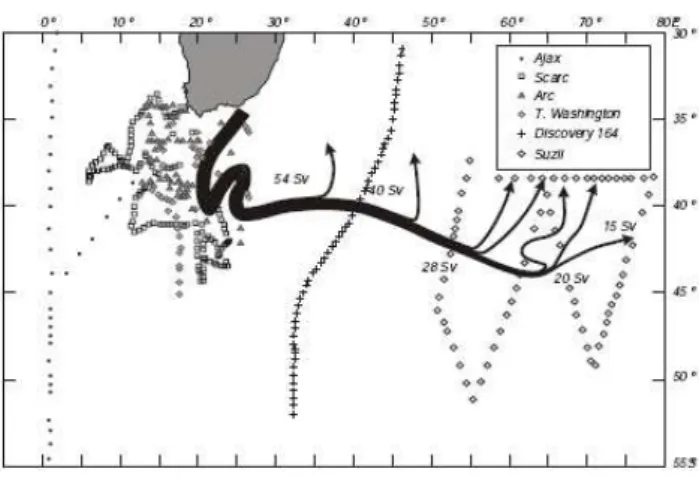
Fig. 13. The trajectory and volume flux of the Agulhas Return Cur-rent based on a collection of hydrographic data collected over the past few decades (after Lutjeharms and Ansorge, 2001). The cruises from which these data derive are given in the inset. By 65◦E the current has all but petered out.
higher continental escarpment – such interaction may result in upwelling filaments being drawn up to 1000 km offshore (Lutjeharms et al., 1991).
The question remains: what processes trigger the shedding of an Agulhas ring? Could it be a natural consequence of the extreme extension of the Agulhas retroflection loop (e.g. Lutjeharms, 1988a)? Or could passing Natal Pulses cause a short circuit between the Agulhas Current and the Agul-has Return Current? As mentioned above, a careful analy-sis by van Leeuwen et al. (2000) has suggested an answer (Fig. 12). They have shown that over a period of two years 6 Natal Pulses were formed. These moved downstream at a very steady rate of 20 km/day up to a distance of 800 km from Durban where they reached the edge of the wide shelf south of Africa (viz. Fig. 1), the Agulhas Bank. Here shear eddies and persistent cloudiness complicated efforts to fol-low individual Natal Pulses, but taking a cue from Lutje-harms and Roberts (1988), it was assumed that once along the edge of the Agulhas Bank the progress of Natal Pulses would slow to 5 km/day. On this basis it has then been shown (Fig. 12) that each Natal Pulse caused the shedding of an Ag-ulhas ring when it reached the AgAg-ulhas retroflection. This re-sult has also subsequently been confirmed by studies by both Schouten et al. (2002a) and Lutjeharms et al. (2003b). How-ever, the results portrayed in Fig. 12 also show that during these years there was at least one occasion on which a ring was formed without the intervention of a Natal Pulse. The most important aspect of the spawning of rings is the inter-ocean exchange brought about in this way.
What has been learnt over the past decades on the inter-ocean exchange south of Africa has been ably summarised by de Ruijter et al. (1999b). Leakage into the South Atlantic seems to come in three forms: direct leakage, Agulhas fil-aments and Agulhas rings. Gordon et al. (1987) have
esti-mated a very high volume flux of 10 Sv relative to 1500 db for direct leakage on one occasion, but this seems to have been exceptional. Such leakage may move across the Agul-has Bank and not be directly involved in the AgulAgul-has Current or its products such as Agulhas filaments. Transport of only 0.1 Sv was estimated for Agulhas filaments (Lutjeharms and Cooper, 1996). By far the greatest leakage takes place via the shedding of rings. Garzoli and Goni (2000) have estab-lished that the flow across the Cape Basin may consist of 50% Indian Ocean water, but this percentage varies dramatically from year to year. Probably the best estimate of inter-ocean exchange brought about by Agulhas rings has given a volume flux of 7 Sv for water warmer than 8◦C, a heat flux of 0.9 PW
and a salt flux of 78×1012kg/year (Van Ballegooyen et al.,
1994). However, the inter-annual range in these values is large. That part of the southern Agulhas Current that negoti-ates the Agulhas retroflection unscathed moves eastwards as the Agulhas Return Current.
5 Agulhas Return Current
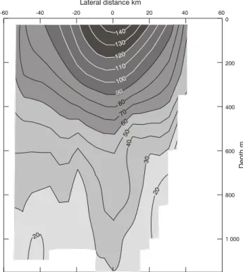
The path of the Agulhas Return Current and its volume flux is shown in Fig. 13. Two important characteristics of the current immediately stand out. First, the current exhibits ex-tensive meanders south of Africa. Second, the volume trans-port of the current diminishes along its path as Agulhas water leaks into the South-West Indian Ocean subgyre. The veloc-ity structure of the Agulhas Return Current near the retroflec-tion is shown in Fig. 14.
The width of the current as well as its vertical structure here still bears a strong resemblance to that of the Agul-has Current proper (viz. Beal and Bryden, 1999), as may have been expected. Overall the velocities are nevertheless somewhat reduced. In the southern Agulhas Current surface speeds of up to 2 m/s may be found. A volume transport of about 55 Sv to a depth of 1500 m has been estimated for the Agulhas Return Current here. The total vertical extent of the Agulhas Return Current has as yet not been measured.
The Agulhas Return Current flows along the Subtropical Convergence south of Africa. This front has been shown to exhibit one of the most strongly developed meridional gradi-ents in temperature and salinity (e.g. Lutjeharms and
Valen-tine, 1984); a 6◦C drop in temperature over a distance of
20 km being not unknown. The current does not always fol-low the front closely thus leading to a double front of which the northern one has then been called the Agulhas Front (e.g. Belkin and Gordon, 1996). This front, as could be expected, has been shown (Kostianoy et al., 2004) to extend no further
than about 75◦E, the longitude at which the Agulhas Return
Current has also died out based on estimates of its volume transport, its geostrophic velocity as well as its Agulhas Cur-rent water characteristics (Lutjeharms and Ansorge, 2001). This same zonal limit is also evident in the distribution of mesoscale turbulence as inferred from the variability of sea
surface height (e.g. Cheney et al., 1983). Last, but by no means least, the zone in which the Agulhas Return Current is found exhibits high concentrations of chlorophyll-a (e.g. Lut-jeharms et al., 1986b; Weeks and Shillington, 1996). This
strong signal also stops at a longitude of about 70◦E. The
relationship between mesoscale variability and high primary productivity has been demonstrated to come about by the in-creased event-scale productivity in eddies at the Subtropical Convergence (Llido et al., 2005). One can therefore assume with some confidence that the Agulhas Return Current
termi-nates between 70 and 80◦E and that the subsequent eastward
flow is the South Indian Ocean Current (Stramma, 1992). Why should there be this increase in mesoscale turbulence along the path of the Agulhas Return Current?
Many observations across and at the Subtropical Con-vergence south of Africa during the past few decades have shown the prevalence of eddies of various dimensions here (Lutjeharms and Valentine, 1988a). These eddies come in various shapes and sizes and are believed to be largely due to the shear instability induced by the Agulhas Return Current juxtaposed with the Subtropical Convergence. Cold eddies are shed on the equatorward side, whereas warm eddies may be taken up by the cold waters south of the Subtropical Con-vergence (Lutjeharms, 1988b). If not totally dissipated it is believed that both sets of eddies drift back towards the parent front in line with their vorticity. Studies with RAFOS floats (Boebel et al., 2003b) during the 1990s have indicated that such eddies may move westward after having been shed; this agrees with findings of meanders in the Subtropical Conver-gence that tend to move westward (Weeks and Shillington, 1996). The origin of these meridional meanders has been adequately described.
Figure 13 shows in elementary terms the major meander in the Agulhas Return Current. It has also been described using drifters (Gr¨undlingh, 1978) and satellite imagery (Lut-jeharms and Valentine, 1988b). The cause of this meander is a major obstruction in the path of the eastward movement of water in the Agulhas Return Current, the shallow Agulhas Plateau. Downstream of the Agulhas Plateau the extension of the Mozambique Plateau may cause a secondary meander (Harris, 1970; Gr¨undlingh, 1978) for the same reason. Mod-elling the current in a number of ways (e.g. Lutjeharms and van Ballegooyen, 1984; Boudra et al., 1989; Matano, 1996) all show the decisive influence of the bottom topography on the path of the Agulhas Return Current. Suggestions that the meanders so caused will persist as a wave of diminishing amplitude to the east (Pazan and Niiler, 2004) have still to be proven.
The Agulhas Return Current forms an outflow from the greater Agulhas Current system; the sources of the Agulhas Current form the inflow.
De pt h m 1 000 800 600 400 200 0 -60 -40 -20 0 20 40 60 Lateral distance km 0 14 130 2 1 0 110 00 1 900 9 80 70 60 50 40 30 20 0 2
Fig. 14. A vertical speed section across the Agulhas Return Current based on observations with RAFOS floats at intermediate depths combined with acoustic Doppler current meter readings in the upper 400 m (after Boebel et al., 2003b). Speeds given are in cm/s and are in the downstream direction.
6 Sources of the Agulhas Current
Classically, as seen in most atlases and text books, the Ag-ulhas Current is a straightforward extension of an upstream western boundary current, the Mozambique Current (e.g. Fig. 1). The other tributary has been portrayed as water flow-ing directly from the southern limb of the East Madagascar Current into the Agulhas Current at a latitude of about 30◦E (e.g. Michaelis, 1923; Paech, 1926). These early interpreta-tions were based on observainterpreta-tions of ships’ drift and on oc-casional observations of sea surface temperatures. Modern analyses of such data (Lutjeharms et al., 2000d) and of histor-ical hydrographic data (Harris, 1972) allow much the same interpretation, as do early numerical models (e.g. Luther and O’Brien, 1989). However, a careful analysis of all historical hydrographic data available at the time has shown (Sætre and Jorge da Silva, 1984) that the circulation in the Mozambique Current might be considerably more complicated than a sim-ple western boundary current. Altimetric observations have incongruously indicated (e.g. Gordon et al., 1983) that the Mozambique Channel is a region of high levels of variabil-ity, in conflict with the concept of a neat western boundary current. This conundrum has been removed by dedicated ob-servations in the channel during the ACSEX (Agulhas Cur-rent Sources Experiment) programme of the past ten years (De Ruijter et al., 2006).
Fig. 15. The flow regime in the Mozambique Channel during the ACSEX I cruise of March–April 2000 (according to De Ruijter et al., 2002). Grey shades indicate sea surface height anomalies. Cur-rents represent those measured over the top 200 m of the water col-umn.
In Fig. 15 the results of the first cruise of this programme are shown (De Ruijter et al., 2002). Instead of a continuous current, a street of anti-cyclonic eddies drifting southward was found. From satellite altimetry it was furthermore estab-lished that these eddies are a persistent and inherent part of the flow regime in the Mozambique Channel (Schouten et al., 2003). They are formed near the narrows of the channel (Rid-derinkhof and de Ruijter, 2003), are oligotrophic – in contrast to the otherwise fairly chlorophyll-rich ambient water masses of the Mozambique Channel – and interact with the shelf wa-ters by drawing out filaments from them. It has been shown that they follow a fairly constrained path along the western side of the channel, eventually moving parallel and fairly close to the Agulhas Current. During their southward move-ment they steadily increase in energy, as presented in sea sur-face height anomalies. Eddies have also been observed in the eastern Mozambique Channel (Quartly and Srokosz, 2004), but these have been assumed to come from south of Mada-gascar.
Persistent and intense lee eddies have furthermore been found in offsets of the Mozambican coastline, such as in the Delagoa Bight (Lutjeharms and Jorge da Silva, 1988) and south of Angoche. These eddies cannot be considered en-tirely peripheral compared to the major flow regime; they may in fact play an important role in the ecosystem of the region. Nehring et al. (1987) have for instance shown that by
Fig. 16. A conceptual image of the inferred movement of water in the vicinity of the southern tip of Madagascar (after Lutjeharms et al., 1981). Open arrows denote wide, slow flow while the intense flow of the southern limb of the East Madagascar Current and of the Agulhas Current are shown by solid arrows. The well defined Mozambique Current in this conceptual picture has subsequently been shown to be a wrong interpretation of contemporary data.
far the highest values of chlorophyll-a in the channel are to be found in the Angoche lee eddy. Finer resolution modelling of the region (e.g. Biastoch and Krauss, 1999; Chapman et al., 2003) has simulated the creation of Mozambique eddies admirably. With the advent of the ACSEX and LOCO (Long Term Ocean Climate Observations) (De Ruijter et al., 2006) during the past decade, knowledge and understanding of the circulation in the Mozambique Channel has thus been revo-lutionised. Regrettably this is not yet the case for the other supposed tributary to the Agulhas Current, the southern limb of the East Madagascar Current.
The East Madagascar Current has been shown to be a small western boundary current fed largely by the South
Equatorial Current. At a latitude of about 17◦S this zonal
inflow from the east splits to form the northern (Swallow et al., 1988) and the southern limb of the East Madagascar Cur-rent (Fig. 16). First dedicated hydrographic observations of the termination of the southern limb of the East Madagascar Current in the 1960s showed no evidence of a direct connec-tion to the Agulhas Current; the waters south of Madagascar on this occasion actually moving eastward (Lutjeharms et al., 1981). Subsequent studies using satellite observations and the tracks of drifters (e.g. Lutjeharms, 1988c, d; Quartly and Srokosz, 2002) have given strong indications that the current retroflects, with most of its water being returned eastward (Fig. 16). Other studies (e.g. De Ruijter et al., 2003) suggest that the termination of the southern limb of the East Mada-gascar Current may on occasion be in the form of a free west-ward jet, generating vortex dipoles south of the Mozambique Channel. These dipoles are clearly seen in satellite observa-tions of ocean colour since the northern cyclones that form
Fig. 17. A portrayal of the volume transport in the South-West In-dian Ocean subgyre. The calculated baroclinic transport is for the upper 1000 m and is given in Sverdrup (after Stramma and Lutje-harms, 1997). Thin lines represent the lines of hydrographic sta-tions on which these calculasta-tions are based.
part of these vortex pairs carry largely shelf water from south of Madagascar. On this shelf there is a coastal upwelling cell (DiMarco et al., 2000; Machu et al., 2003) that has been shown to be driven by the strong adjacent current and not by the prevailing winds (Lutjeharms and Machu, 2000).
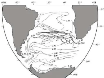
The third, but by far the largest contributor to the flow of the Agulhas Current has been shown to be recirculation in a South-West Indian Ocean subgyre (Fig. 17). Whereas the volume transport in the upper 1000 m through the Mozam-bique Channel is here shown to be only 5 Sv and that esti-mated from the southern limb of the East Madagascar Cur-rent 20 Sv, at best, the flux that comes from the recirculation is 40 Sv. Of this 40 Sv at least 35 Sv peels off the Agulhas
Return Current west of 70◦E, as was mentioned before when
discussing this current. These three sources of the Agulhas Current proper do not only contribute volume flux, but have been shown to have some important controlling effects on the behaviour of the current.
Mozambique eddies moving poleward from the Mozam-bique Channel have been shown to get adsorbed onto the sea-ward border of the Agulhas Current (Schouten et al., 2002a; De Ruijter et al., 2005), to then trigger a Natal Pulse that subsequently brings about the shedding of an Agulhas ring at the Agulhas Current retroflection. Mozambique eddies have therefore been surmised as being a factor that controls inter-ocean exchange south of Africa. The frequency with which these Mozambique eddies are formed may in turn be con-trolled by Rossby waves travelling zonally across the South Indian Ocean (Schouten et al., 2002b; De Ruijter et al., 2005) and these waves may have their primary origin in seasonal wind stress changes in the Arabian Sea. A second stimulus for Natal Pulse generation may be eddies coming from the east. At least one case of such a trigger from the east has been found to date (T. Lamont, personal communication).
Fig. 18. A conceptual portrayal of the flow patterns in the greater Agulhas Current (after Lutjeharms, 2006a) as they are currently un-derstood. In order to assess what has been learnt about this system over the past three decades, a comparison between this figure and Fig. 1 should be very instructive.
7 Conclusions
A pictorial presentation of current understanding on the greater Agulhas Current system is given in Fig. 18. When compared to Fig. 1 it is clear how much has been learnt dur-ing the past 30 years.
First, the southern termination of the Agulhas Current has been studied intensively and the retroflection of the current and the ring shedding process established in considerable detail. The subsequent behaviour of Agulhas rings and the manner in which they disperse their load of salt and heat in the South Atlantic Ocean has also been studied extensively. It has been demonstrated that this insertion of heat and salt con-tributes to the meridional overturning of the Atlantic Ocean as a whole. This heat dispersal is highly dependent on the interaction of the water in the Agulhas Current or in its rings with the overlying atmosphere. An extensive and protracted investigation has made a major contribution to current under-standing of the processes involved in such sea-air interaction. In fact, the influence of the warm waters of the Agulhas Cur-rent and sea surface temperature anomalies in general on the weather and climate of the adjacent subcontinent has become and remains a major field of investigation.
A major advance has been made in determining the nature of the supposed tributaries of the Agulhas Current, namely the flow through the Mozambique Channel, from east of Madagascar and in the South Indian Ocean gyre. The discov-ery that no western boundary current exists in the Mozam-bique Channel has been a major advance. A look at Fig. 1 clearly shows the ignorance on these currents that existed in the early 1970s.
Of particular importance has been the identification of those aspects of the Agulhas Current that make it unique as a western boundary current. This has included the distinguish-ing characteristics of the southern and the northern Agulhas Current and in particular the extraordinary path stability of the northern component of this current. The discovery of the Natal Pulse, the eddies that may trigger it, the influence it has on Agulhas ring shedding and the impact it may thus have on inter-ocean water exchanges when it forces an up-stream retroflection, all these have contributed substantially to a better understanding of the mechanics of the system.
Modelling of the system has also advanced rapidly and simulations are increasingly realistic. In many cases models suggest certain processes the trustworthiness of which can-not currently be verified because of a lack of data. So what are the main processes that remain poorly understood?
The flow patterns in the Mozambique Channel as a whole still are not well known, particularly in the Comores Basin in the northern mouth of the channel as well as the whole eastern side, where there are regions that have never been hy-drographically surveyed at all. The East Madagascar Current has never been properly surveyed as a unit and its supposed retroflection has not been investigated adequately. Our cur-rent knowledge on the Agulhas Return Curcur-rent is similarly based on a collection of non-synoptic hydrographic surveys of varying quality. In all of these cases dedicated, multi-disciplinary cruises would seem the best way to remove part of existing ignorance. The finding that mesoscale features such as eddies trigger Natal Pulses and thus may control the globally important inter-ocean exchanges south of Africa was totally unexpected, but much more needs to be done to properly understand how this comes about. When looking at the system on the sub-mesoscale, the number of research questions abounds even more.
What drives the coastal upwelling off south-eastern Mada-gascar? What impact does the Angoche lee eddy have on its direct environment? What influence do the passing Mozam-bique eddies have on the Delagoa Bight eddy? Since sed-iment patterns on the shelf north of Richards Bay indicate northward flow, where does the Agulhas Current actually start? What is the effect of the St. Lucia upwelling cell on the water masses of the Natal Bight? Is the seasonal ther-mocline on the Agulhas Bank largely driven by the cold wa-ter coming from the Port Alfred upwelling cell? How con-stant is the presumed inflow of cold bottom water at the Port Alfred upwelling cell? What role do shear edge filaments of the southern Agulhas Current play in the heat budget of the waters of the Agulhas Bank? Where do Cape Basin cy-clones come from and what causes their formation? The list seems endless and largely subjective. Nevertheless, dedi-cated cruises seem to be called for here as well, but in many cases longer term monitoring with appropriately placed cur-rent meter moorings would be essential for a proper under-standing of the underlying processes. The breadth and depth of fundamental questions on the greater Agulhas Current
sys-tem that can now be asked is itself an artefact of the progress that has been made on the understanding of the system. This raises the question why such progress was made in the first place. This might indicate how to proceed efficaciously in future. A number of factors stand out particularly clearly.
First, in a region far away from the main centres of ship-going oceanographic research the advent of readily available satellite remote sensing has been the cause of an observa-tional revolution. Since the southern parts of the Agulhas Current are thermally strongly identifiable at the sea surface, thermal infrared imagery was a decided boon to early inves-tigations (e.g. Lutjeharms, 1981). Subsequent access to the first remotely sensed ocean colour from satellite (Shannon, 1979) and more recently to the SeaWiFS (Sea-viewing Wide Field Sensor) has added to this enormous benefit for study-ing the Agulhas Current system (e.g. Weeks and Shillstudy-ington, 1996). These means of observing, particularly in the ther-mal infrared, have limited uses in regions where there are no substantial temperature or colour contrasts at the sea surface or where there is persistent cloud cover. The latter problem has been largely removed with the introduction of microwave observations (Rouault and Lutjeharms, 2003) and both with altimetric observations (Gr¨undlingh, 1988). The latter has lead to what may be considered a second revolution in stud-ies of the Agulhas Current system. It is not only this avail-ability of new observational technologies that has facilitated this stupendous growth in knowledge on the Agulhas Current system, but also the international recognition of the global importance of the system.
One of the first to recognise this was Gordon (e.g. 1985, 1986) who organised one of the first major modern cruises in the region, the aforementioned ARC (Agulhas Retroflection Cruise) in 1983. This was followed by the SCARC (Subtrop-ical Convergence and Agulhas Retroflection Cruise; Lutje-harms, 1987), the KAPEX (Cape of Good Hope Experiment; Boebel et al., 1997), the MARE (Mixing in Agulhas Rings Experiment; Lutjeharms et al., 2000c) and the ACSEX (Ag-ulhas Current Sources Experiment; De Ruijter et al., 2006), all large scale observational programmes dedicated to a bet-ter understanding of components of the greabet-ter Agulhas Cur-rent. The BEST (Benguela Sources and Transport; Pillsbury et al., 1994) project was based on current meter moorings in the South Atlantic Ocean in the path of Agulhas rings as is the ASTTEX (Agulhas-South Atlantic Thermohaline Trans-port Experiment). The ACE (Agulhas Current Experiment; Beal and Bryden, 1999) consisted of current meter place-ments in the Agulhas Current proper. This broad interna-tional interest and participation has helped to lift the study of the Agulhas Current onto a new level. What does this suggest for the future?
A number of international programmes are being planned to address some of the questions mentioned above, as are a number of modelling projects aimed specifically at the Agul-has Current system. A particular requirement will be to study some of the important adjacent shelves and the interaction of
the offshore currents with these. This could start soon as part of the ASCLME (Agulhas and Somali Current Large Ma-rine Ecosystem) project. Prediction of future developments is fraught with obvious problems and limitations, but it is difficult to imagine the same number of fundamental discov-eries on the greater Agulhas Current being made during the next few decades as have been made during the past three.
Acknowledgements. This review closely follows the contents of the Fridtjof Nansen Medal Lecture held at the annual general assembly of the European Geosciences Union in Vienna in 2006. I thank the medal committee who thought it fit to award me this distinction and for those overly generous souls who nominated me. It came at a personally difficult time and was therefore all the more appreciated. I am particularly grateful to W. de Ruijter of the University of Utrecht, A. Gordon of Columbia University, T. Rossby of the University of Rhode Island, O. Boebel of the Alfred Wegener Institute for Polar and Marine Research and a host of other colleagues such as R. van Ballegooyen, H. Valentine and I. Ansorge for collaboration over many years that has substantially enhanced my own modest contribution to progress on our under-standing of the greater Agulhas Current system and made it a lot of fun. Due to length limitations I have regrettably had to leave out of this survey a large number of valuable contributions, something that will be obvious to anybody knowledgeable about the system. This omission is corrected by a much more detailed and in depth overview of what is currently known about the greater Agulhas Current that is to be found in the book “The Agulhas Current” (Lutjeharms, 2006b; Springer-Verlag, Berlin).
Edited by: J. M. Huthnance
References
Anderson, F. P., Gr¨undlingh, M. L., and Stavropoulos, C. C.: Kine-matics of the southern Natal coastal circulation: some historic measurements 1962–63, S. Afr. J. Sci., 84, 857–860, 1988. Arhan, M., Mercier, H., and Lutjeharms, J. R. E.: The disparate
evolution of three Agulhas rings in the South Atlantic Ocean, J. Geophys. Res., 104, 20 987–21 005, 1999.
Bang, N. D.: Major eddies and frontal structures in the Agul-has Current retroflexion (sic) area in March, 1969, in: Sym-posium “Oceanography South Africa 1970”, South African Na-tional Committee for Oceanographic Research, 16 pp., 1970a. Bang, N. D.: Dynamic interpretations of a detailed surface
tempera-ture chart of the Agulhas Current retroflexion (sic) and fragmen-tation area, S. Afr. geogr. J., 52, 67–76, 1970b.
Bang, N. D.: Characteristics of an intense ocean frontal system in the upwell regime west of Cape Town, Tellus, 25, 256–265, 1973a.
Bang, N. D.: Oceanography: Oceanographic Environment of Southern Africa, in: Standard Encyclopaedia of Southern Africa, edited by: Spies, J. J. and du Plessis, P. C., vol. 8, Nasou, Cape Town, pp. 282–286, 1973b.
Beal, L. M. and Bryden, H. L.: Observations of an Agulhas Under-current, Deep-Sea Res. I, 44, 1715–1724, 1997.
Beal, L. M. and Bryden, H. L.: The velocity and vorticity structure of the Agulhas Current at 32◦S, J. Geophys. Res., 104, 5151– 5176, 1999.
Beckley, L. E.: Sea-surface temperature variability around Cape Re-cife, South Africa, S. Afr. J. Sci., 79, 436–438, 1983.
Beismann, J.-O., K¨ase, R. H., and Lutjeharms, J. R. E.: On the influ-ence of submarine ridges on translation and stability of Agulhas rings, J. Geophys. Res., 104, 7897–7906, 1999.
Biastoch, A. and Krauss, W.: The role of mesoscale eddies in the source regions of the Agulhas Current, J. Phys. Oceanogr., 29, 2303–2317, 1999.
Boebel, O., Duncombe Rae, C., Garzoli, S., Lutjeharms, J., Richardson, P., Rossby, T., Schmid, C., and Zenk, W.: Float ex-periment studies interocean exchanges at the tip of Africa, Eos, Trans. Am. geophys. Un., 79(1), 7–8, 1997.
Boebel, O., Lutjeharms, J., Schmid, C., Zenk, W., Rossby, T., and Barron, C.: The Cape Cauldron: a regime of turbulent inter-ocean exchange, Deep-Sea Res. II, 50, 57–86, 2003a.
Boebel, O., Rossby, T., Lutjeharms, J., Zenk, W., and Barron, C.: Path and variability of the Agulhas Return Current, Deep-Sea Res. II, 50, 35–56, 2003b.
Belkin, I. M. and Gordon, A. L.: Southern Ocean fronts from the Greenwich meridian to Tasmania, J. Geophys. Res., 101, 3675– 3696, 1996.
Boudra, D. B., Maillet, K. A., and Chassignet, E. P.: Numerical modeling of Agulhas retroflection and ring formation with isopy-cnal outcropping, in: Meso-scale/Synoptic Coherent Structures in Geophysical Turbulence, edited by: Nihoul, J. C. J. and Ja-mart, B. M., Elsevier, Amsterdam, pp. 315–335, 1989.
Boyd, A. J., Tromp, B. B. S., and Horstman, D. A.: The hydrology of the South African south-western coast between Cape Point and Danger Point in 1975, S. Afr. J. Mar. Sci., 3, 145–168, 1985. Boyd, A. J., Taunton-Clark, J., and Oberholster, G. P. J.: Spatial features of the near-surface and midwater circulation patterns off western and southern South Africa and their role in the life histo-ries of various commercially fished species, S. Afr. J. Mar. Sci., 12, 189–206, 1992.
Byrne, D. A., Gordon, A. L., and Haxby, W. F.: Agulhas Eddies: a synoptic view using Geosat ERM data, J. Phys. Oceanogr., 25, 902–917, 1995.
Carter, R. and d’Aubrey, J.: Inorganic nutrients in Natal continental shelf waters, in: Coastal Ocean Studies off Natal, South Africa, edited by: Schumann, E. H., Lecture Notes on Coastal and Estu-arine Studies 26, Springer-Verlag, Berlin, pp. 131–151, 1988. Carter, R. A. and Schleyer, M. H.: Plankton distributions in
Na-tal coasNa-tal waters, in: CoasNa-tal Ocean Studies off NaNa-tal, South Africa, edited by: Schumann, E. H., Lecture Notes on Coastal and Estuarine Studies 26, Springer-Verlag, Berlin, pp. 152–177, 1988.
Chapman, P., DiMarco, S. F., Davis, R. E., and Coward, A. C.: Flow at intermediate depths round Madagascar based on ALACE float trajectories, Deep-Sea Res. II, 50, 1957–1986, 2003.
Cheney, R. A., Marsh, J. G., and Beckley, B. D.: Global mesoscale variability from collinear tracks of SEASAT altimeter data, J. Geophys. Res., 88, 4343–4354, 1983.
Christensen, M. S.: Sea-surface temperature charts for Southern Africa, south of 26◦S, S. Afr. J. Sci., 76, 541–546, 1980. Crimp, S. J., Lutjeharms, J. R. E., and Mason, S. J.: Sensitivity of
a tropical-temperate trough to sea-surface temperature anomalies in the Agulhas retroflection region, Water SA, 24, 93–101, 1998. De Ruijter, W.: Asymptotic analysis of the Agulhas and Brazil