HAL Id: hal-00298999
https://hal.archives-ouvertes.fr/hal-00298999
Submitted on 1 Jan 2003
HAL is a multi-disciplinary open access
archive for the deposit and dissemination of
sci-entific research documents, whether they are
pub-lished or not. The documents may come from
teaching and research institutions in France or
abroad, or from public or private research centers.
L’archive ouverte pluridisciplinaire HAL, est
destinée au dépôt et à la diffusion de documents
scientifiques de niveau recherche, publiés ou non,
émanant des établissements d’enseignement et de
recherche français ou étrangers, des laboratoires
publics ou privés.
examples from Hungary
J. Szabó
To cite this version:
J. Szabó. The relationship between landslide activity and weather: examples from Hungary. Natural
Hazards and Earth System Science, Copernicus Publications on behalf of the European Geosciences
Union, 2003, 3 (1/2), pp.43-52. �hal-00298999�
Natural Hazards and Earth System Sciences (2003) 3: 43–52 c
European Geosciences Union 2003
Natural Hazards
and Earth
System Sciences
The relationship between landslide activity and weather: examples
from Hungary
J. Szab´o
Department of Physical Geography, P.O. Box 9, H-4010 Debrecen, Hungary Received: 27 November 2001 – Revised: 7 May 2002 – Accepted: 8 May 2002
Abstract. The paper presents the impact of irregular rainfall events triggering landslides in the regional context of land-slides in Hungary. The author’s experience, gathered from decades of observations, confirms that landslide processes are strongly correlate with precipitation events in all three landscape types (hill regions of unconsolidated sediments; high bluffs along river banks and lake shores; mountains of Tertiary stratovolcanoes). Case studies for each landscape type underline that new landslides are triggered and old ones are reactivated by extreme winter precipitation events. This assertion is valid mainly for shallow and translational slides. Wet autumns favour landsliding, while the triggering influ-ence of intense summer rainfalls is of a subordinate nature. A recent increasing problem lies in the fact that on previously unstable slopes, stabilised during longer dry intervals, an in-tensive cultivation starts, thus increasing the damage caused by movements during relatively infrequent wet winters.
1 Introduction
One of the most frequent causes of landsliding is the de-creased stability of slope material, related particularly in the case of unconsolidated sediments to a sudden change in wa-ter content. In general, the moisture content of slopes de-pends mainly on climate, and in particular on weather condi-tions. The latter explains primarily why landsliding is dis-continuous in time and space, even where conditions are favourable. The discontinuity in time may be related to cli-matic change on a large scale (e.g. an arid climate becomes more humid), to the seasonal humidity of the climate in the medium term (e.g. movements are more common in wet sea-sons) and to climatic extreme events in the short term (e.g. unexpectedly abundant precipitation). However, this regular-ity, which may be regarded as general, is manifested in dif-ferent forms in various physical landscape types. As a con-sequence, the contribution of slides and the features created Correspondence to: J. Szab´o (wagner@tigris.klte.hu)
by them may be largely variable in the geomorphic evolution of regions where conditions are favourable. Rock quality, stratification, slopes with high variability locally (e.g. as a result of lateral river erosion) lead to various landslide types, and the changing weather conditions affect them in different ways.
The paper investigates some aspects of the relationship be-tween landslides and weather in the regional context of land-slides in Hungary (Szab´o, 1992, 1993, 1996a). In addition, the author introduces some case studies, particularly from the northeastern part of the country.
2 Methods
The author has been investigating landslides and the fea-tures produced by them for more than thirty years. Research has been focused primarily on the northeastern part of Hun-gary, where projects of detailed geomorphological mapping have been carried out for several hill regions. Field experi-ence covers all regions of Hungary affected by landsliding. Following a range of partial reports, in 1996, a comprehen-sive evaluation was prepared on the contribution of lands-liding to the geomorphic evolution of Hungarian landscapes (Szab´o, 1996a). This paper exploits previous experience sup-plemented with additional data on rainfall and analyses of the conditions of some new or reactivated landslides (e.g. at Holl´oh`aza), in order to point out typical features in the pre-cipitation/landslide relationship.
2.1 Regional distribution of landslides in Hungary
More than two-thirds of the area of Hungary, occupying the central part of the Carpathian Basin, is lowlands, but land-slides occur in 107 (47%) of the 230 physical microregions conventionally identified (Szab´o, 1996b). This is explained by the fact that the landscape pattern of areas of higher re-lief and dissection is finer (usually smaller microregions are delimited) and unconsolidated sediments predominate.
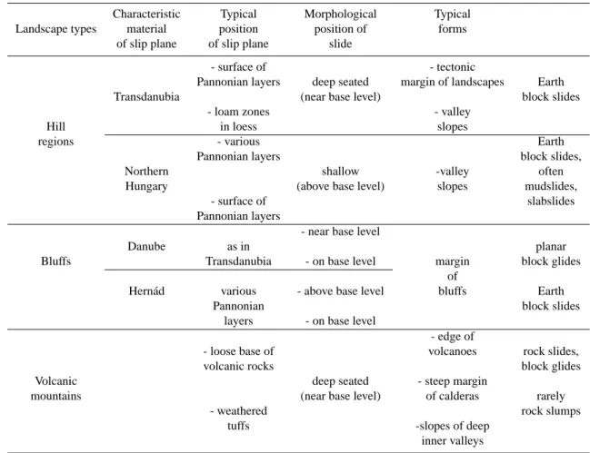
Table 1. Regional distribution of landslides in Hungary. Nomenclature after Hansen (1984), Simonett (1968), Hutchinson (1968)
Characteristic Typical Morphological Typical Landscape types material position position of forms
of slip plane of slip plane slide
- surface of - tectonic
Pannonian layers deep seated margin of landscapes Earth Transdanubia (near base level) block slides
- loam zones - valley
Hill in loess slopes
regions - various Earth
Pannonian layers block slides,
Northern shallow -valley often
Hungary (above base level) slopes mudslides,
- surface of slabslides
Pannonian layers
- near base level
Danube as in planar
Bluffs Transdanubia - on base level margin block glides of
Hern´ad various - above base level bluffs Earth
Pannonian block slides
layers - on base level
- edge of
- loose base of volcanoes rock slides,
volcanic rocks block glides
Volcanic deep seated - steep margin
mountains (near base level) of calderas rarely
- weathered rock slumps
tuffs -slopes of deep inner valleys
There are three landscape types in Hungary where past or present geomorphic evolution has been significantly in-fluenced by landsliding, and landslides are major features in the landscape. This primarily refers to landslides of a natu-ral origin, but with the expansion of intensive land use types; man-induced landslides have also been reported as a consid-erable hazard.
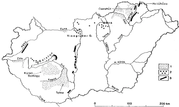
The distribution of areas with a high landslide density (more than 1 landslide per 1 km2) or with a high landslide hazard is shown in Fig. 1, whereas Table 1 provides a com-prehensive description of landslide-affected landscape types. – A Hills built up of Tertiary (mainly Neogene) sediments
Hills in southern Transdanubia. The low stability slopes are typically built up of Upper Miocene (Pan-nonian) marine-lacustrine loams and sands with a thick (20–40 m) loess mantle. Since the stability of loess is relatively higher than the Pannonian sediments, sliding is concentrated mainly on slopes of deeply incised val-leys, exposing Pannonian deposits under loess. Such landslides are usually deep-seated and their slip planes are located under the loess in the Pannonian sediments. As a consequence, the large moisture content causing landslides is not directly related to precipitation (the
wa-ter does not infiltrate through the thick loess layer), but indirectly through groundwater flow.
Hilly regions in the North Hungarian Mountains. The majority of the natural landslides occur in the area of Pannonian sediments. These deposits present the low-est stability in Hungary. They are not usually covered by loess but by a Plio-Pleistocene veneer of equally low stability. Consequently, shallow slip planes are formed mostly below the base level. The surface extension of landslides is usually remarkable but their thickness is small. The D/L ratio of Skempton (Crozier, 1973) is only a few percent. Therefore, landslides are more di-rectly linked to precipitation. (In hill regions made up of older – Oligocene and Lower-Middle Miocene – sed-iments, landslides of natural origin are less common.) – B Landslides along bluffs
Landsliding is a common phenomenon along the River Danube (south of Budapest) and along the high bluffs around Lake Balaton, as described in the literature (P´ecsi et al., 1993; L´oczy et al., 1989; P´ecsi, 1994; Juh´asz and Schweitzer, 1989; Juh´asz, 1999). The land-slides along the southern shore of Ferto Lake, the right bank of R´aba River and the movements of the bluffs of
J. Szab´o: The relationship between landslide activity and weather 45
Fig. 1. Regions affected by high landslide density in Hungary. 1 = hill regions with landslides, 2 = buff zones with landslides, and 3 = mountains of volcanic origin with landslides.
Hern´ad River are less studied – although the latter is the most active landslide zone in Hungary. A common char-acteristic of mass movements of the regions, geograph-ically distant from each other, is that in the majority of the cases, the bluffs are built up of Pannonian deposits (Table 1). The cover deposits of Pannonian sediments are variable for type and thickness. This variability sig-nificantly influences the nature and location of the slip planes and the features of landslides.
– C Landslides in mountains of volcanic origin.
The landslide features of Hungarian mountains of vol-canic origin present a different lithological environ-ment. The volcanoes were active in the middle and late Miocene. Their lava and pyroclastic products (with a strato-volcano structure) accumulated on Neogene sed-iments. The landslides of the volcanic mountains devel-oped in three distinct geomorphological situations:
a) along the edge of volcanoes, where unconsoli-dated bedrock is exposed on the surface and these sed-iments of low stability form the slip plane for the slid-ing volcanic rock masses. Such a stratification occurs frequently and typical sliding zones have been reported along the mountain margins;
b) within the mountains, on the steep margins of former calderas;
c) on the slopes of deep valleys dividing the moun-tains, where a valley incision reached the rocks under-lying the volcanic products.
Sometimes slip planes of landslides also appear within the strato-volcanic structure. Particularly heavily decomposed
tuff layers form sliding surfaces. Landslide hazard is es-pecially high if these impermeable or weak weathered tuff aquifers are wedged in between agglomerate masses of high water permeability. The landslides in mountains areas are usually deep-seated (sometimes 100 m deep).
2.2 Climatic and meteorological aspects of landslides In the three landscape types described above, the precondi-tions for landslides are rather different and this variation is also reflected by the mechanisms, activity and morphology of landslides.
Where eroded fossil features are widespread but active slides are missing, major climatic changes must have caused landsliding to stop. Generally, this is the case in mountains of volcanic origin (e.g. in the M´atra and Visegr´ad Moun-tains). In the moors of hollows impounded by landslides, chronological data (Szab´o and F´elegyh´azi, 1997) have been obtained to demonstrate that these movements in the moun-tains were at a rest during most of the Holocene. Their formation may be most probably dated to the beginning of the Holocene, or the warming climatic periods of the Late Glacial and Preboreal phases. The relative intact forms are due to large size and the hard volcanic rocks. There are no similar old features in the hill regions or along the high bluffs, since unconsolidated deposits do not favour their preservation. Thus, deep seated, large-scale rockslides do not constitute a real hazard under the present climatic conditions. In several volcanic mountains in Hungary, their zonally ar-ranged remnants attest to a climatic phase when periglacial conditions ceased to exist and humid environments suitable for large-scale landslides prevailed.
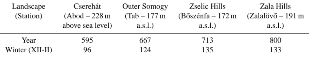
Table 2. Annual and winter mean precipitation (mm) in Csereh´at and in various hill regions of Transdanubia (based on data of representative stations: 1901–1975)
Landscape Csereh´at Outer Somogy Zselic Hills Zala Hills (Station) (Abod – 228 m (Tab – 177 m (B˝osz´enfa – 172 m (Zalal¨ov˝o – 191 m
above sea level) a.s.l.) a.s.l.) a.s.l.)
Year 595 667 713 800
Winter (XII-II) 96 124 135 133
The present-day climate does not allow for the occurrence of landslides of large dimension to seem probable, but there are still recent – or even active – landslides in the volcanic mountains. They are most often found in valleys and valley basins, where decomposed tuffs and other unconsolidated – often marine – sediments are abundant near the surface. The main triggering factor is usually human activity (e.g. road cuts, construction of buildings) that modifies the shape, the loading of the slopes and the moisture conditions (chang-ing the surface water budget, lack of public utilities, etc.). They usually occur irregularly after longer periods of tran-quillity which highly increases their hazards. The periods of tranquillity decreases the focused attention of the popu-lation and construction work takes place on the potentially unstable slopes during decade-long breaks between landslid-ing events.
This is even more typical for landslides in hill regions and along bluffs. The reactivation of landslides may be related to the irregular precipitation distribution under continental climate, to years of wet weather and even more characteris-tically to heavy rainfall in extreme weather situations. Par-ticularly for shallow landslides, exceptionally high precipita-tion and the reactivaprecipita-tion of landslides are strongly correlated. Relatively precise correlation can be revealed since the be-ginning of regular precipitation measurements (in Hungary mostly until the early 20th century). More correlation can be verified up to a few decades, which is within the range of ex-isting human memory about landslides. During the author’s own landslide investigations of the past three decades, direct evidence was gathered to confirm the above relationships.
3 Case studies
3.1 Hill regions (Csereh´at) 3.1.1 Lithology and relief
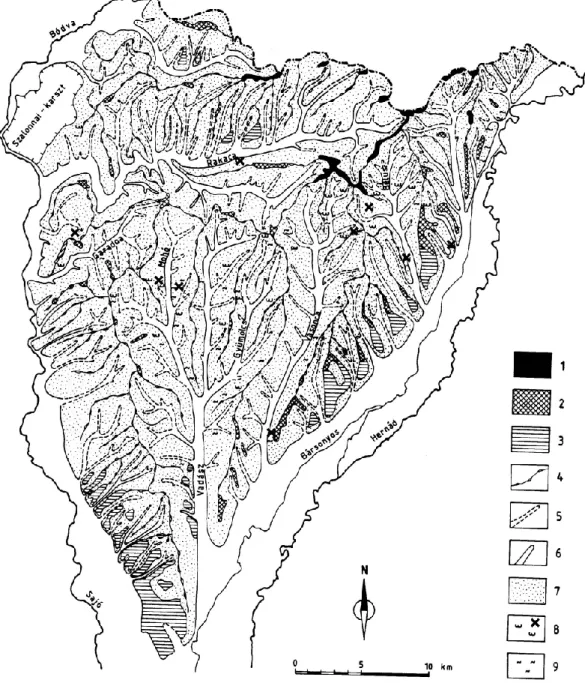
In the northernmost hill region of the country, the Csereh´at (Fig. 2), between B´odva and Hern´ad Rivers, valleys are cut into Pannonian lacustrine-marine loams and sands sedi-ments except for the western margins, entirely dissecting the Pliocene pediment (glacis) surface. Today, its remnants are only detectable in narrow interfluvial ridges, although this is still the landscape with the lowest valley density among all Hungarian hill regions. The primary reason for low valley
density is the low stability of Pannonian sediments. Intense mass movements occurred during the Pleistocene and broad-ened the valleys. Among them, landsliding played the main role.
3.1.2 Landsliding and precipitation
Similar processes also operate under the present climate, al-though the hill region has a low precipitation, especially compared to the Trans-danubian Hills of humid climate. Winter precipitation, an important factor in triggering land-slides, is particularly low (Table 2). Given these conditions, it is expected that landslide activity increases mainly after wet winters with abundant snowfall.
In the spring of 1977, the largest number of new or re-activated landslides was recorded during the thirty years of observation (Fig. 2). The winter of 1976/1977 was espe-cially wet. At one of the measurement stations included in Table 2 (Abod), total precipitation of the winter months was 247 mm, 257% of the 75-year average. Similar ratios were obtained for other stations in the Csereh´at region: Gagyb´ator, 266%; Sziksz´o, 262%. Higher winter precipitation in Hun-gary was measured only once: in the winter of 1914/1915 (in Sziksz´o the precipitation was 348% and in Gagyb´ator it was 287% of the average of 75 years). In the case of the reacti-vated landslides – with a single exception – slip planes were near the surface (at < 3 m depth). Consequently, soils and near-surface sediments became saturated by the end of the winter, creating ideal conditions for shallow (“carpet-like”) landslides. Fortunately, the renewed landslides did not af-fect settlements, and their damage was restricted to agricul-tural land. In the author’s opinion, intensive summer pre-cipitation usually induces considerable soil erosion on the Csereh´at Hills, almost exclusively used for agricultural pur-poses. The landslide-generating impact of summer rains, however, is minimal. The landslides are usually related to winter precipitation.
3.2 High bluffs along the Hern´ad River 3.2.1 Rocks and topography
Along the southern section of the Hern´ad valley, the zone of 70–80 m high bluffs is almost 30 km long and 500–1000 m wide (Figs. 1 and 4). Landslides are major features in this zone. In the bluff, almost exclusively Pannonian deposits,
al-J. Szab´o: The relationship between landslide activity and weather 47
Fig. 2. Geomorphologic map of the Csereh´at Hills. 1 = glacis remnants with gravels (*300 m .a.s.l.) – Upper Pliocene, 2 = broad interfluvial ridges (280–300 m a.s.l.), 3 = river terrace and valley-glacis (Pleistocene), 4 = narrow interfluvial ridges, 5 = derasional (dry) valley, 6 = fluvial valley, 7 = slopes, 8 = active landslides (black crosses show new and reactivated landslides in spring 1977), 9 = temporarily dormant and stabilised landslides. White areas indicate valley floors.
ternating beds of sands and clays-silts, are exposed and only mantled by (< 5 m thick) loess. Although the bluff suscep-tible to landsliding is formed and maintained by lateral ero-sion, the majority of the landslides here are not directly con-trolled by the water level of the river.
In contrast, researchers (Horv´ath and Scheuer, 1976) have pointed out that along the Danube, most of the landslides take place during the steep falling limbs of flood hydrographs. It is explained by the locations of slip planes (bedding planes of Pannonian deposits) which are around the average water level of the Danube at many places. At a high water level,
river water flows between beds decreases their stability. At the same time, the water also functions as a support. The supporting effect, however, ceases during the period of the rapidly dropping water levels.
3.2.2 Landsliding and precipitation
The slip planes of the landslides along the Hern´ad River may be more deeply seated than in the Csereh´at (ca. 5–10 m or even more). They are considerably higher than the highest water level of the river. The water supply inducing land-slides results primarily from the confined groundwater
flow-ing from the inner areas. In some cases, the water infiltrates at the top of the bluffs already affected by sliding.
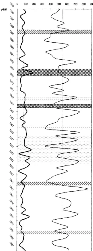
The author’s research showed that the irregular recurrence of landslides may be explained fundamentally by the fluc-tuation in precipitation. Winter precipitation is of particular significance. This conclusion is drawn from the results of the questionnaire survey performed in 6 settlements of the ripar-ian zone (land owners were asked about the dates of move-ments affecting their properties) and from the data of the State Insurance Company. These data sets have been com-pared with the precipitation time series for 75 years (Fig. 3). Attention should be directed to the processes in the mid-seventies. Although no direct observations could be made, local data indicate that disastrous landslides occurred dur-ing the sprdur-ings of 1975 and 1977. Data received from the State Insurance Company show that large sums of compen-sation (approximately USD 25 000 at contemporary price) were paid in 3 villages in the high bluff zone (Fels¨odobsza, Hern´adk´ercs, Szentistv´anbaksa). In Hern´adk´ercs, 13 houses of the part of the settlement built on the bluff were evacuated. This part of the settlement was finally abandoned by the in-habitants. It is worth mentioning that in the poor villages of the Hern´ad valley, property insurance is still an exception. Consequently, the rate of damage could be an order of magni-tude higher than indicated – not to mention the damage made to the gardens along the bluffs.
The winter of 1974/1975 was not really wet but the Octo-ber of 1974 was the wettest OctoOcto-ber in the 20th century (at Gib´art 172 mm fell – 4.1 times more than during the 1901– 1970 period) and led to landsliding in the next spring. The winter of 1976/1977, similar to the Csereh´at Hills, was also exceptionally humid in the Hern´ad Valley (Table 3).
A band chart was prepared for the 20 km long segment of the Hern´ad Bluff (Fig. 4). This indicates grades for the general activity of each slope section, with special emphasis on those areas where there were landslides resumed or new movements occurred in 1975–1977.
3.3 Mountains of volcanic origin (Holl´oh´aza – 1999) 3.3.1 Rocks and topography
Holl´oh´aza, the northernmost settlement in Hungary (Fig. 1), is situated in a valley crossing a strongly eroded Miocene volcanic caldera at 280–520 m above sea level. Here, “rhy-olite tuff and loamy marine sediments of various thickness are superimposed on the underlying andesite” (Zelenka and Trauer, 1999). Their layers dip towards the valley, conduct-ing water in that direction. Another important feature is that bentonitic rhyolite tuff, as well as clays, show an extremely high montmorillonite content (40–50%). The upper part of the alternating tuff and clay beds of high swelling capacity lean mainly against the steep slopes of the mountains built up of lava rock. Most of the water discharge comes along a plane dissecting the surface.
There had been landslides on the slopes over the village even before. Their temporarily stabilised forms may be seen
Fig. 3. Relationship between precipitation and landslide phases in the Hern´ad Valley. Thick line = winter precipitation, thin line = annual precipitation. Dotted stripe = indistinctly defined landslide phase, broken line = distinctly defined landslide phase, dark stripe = interval with intensive landsliding.
J. Szab´o: The relationship between landslide activity and weather 49
Table 3. Precipitation during the winter 1976/1977 and mean winter precipitation 1901–1975 in mm. (Hern´ad Valley)
Station Winter 1976/1977 Total 1 Winter 1901/1975 Total 2 Ratio Dec. Jan. Feb. Dec. Jan. Feb. Total 1/ Total 2 Gib´art 58 70 60 188 35 23 24 82 2.29 Hidasn´emeti 85 81 71 237 39 28 29 96 2.47 Vilm´any 79 73 69 221 46 28 28 102 2.17 Sziksz´o 97 78 62 237 38 26 26 90 2.63
Fig. 4. Activity grades of slope evolution through sliding on the left bank of the Hern´ad between Pere and Gesztely (0–22 km) The toe of the bank is on the left side of the band chart. 1 = slopes without landslide features (grade 0); 2 = bank section with heavily degraded features (grade I); 3 = slope segments with recent slide forms, now at rest (grade II); 4 = recently unstable slope with active segments (grade III); 5 = slope segment dominated by active slides (grade IV); 6 = river undercutting of bluff (black dots show the new and renewed landslides in spring 1977.).
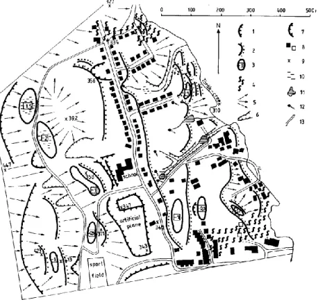
Fig. 5. Geomorphological map of the midwestern part of the village Holl´oh´aza with landslide features 1 = free face of landslides, 2 = margins of landslide steps, 3 = closed depressions of landslides (depth in metres), 4 = unstable surfaces (active movements between 1999–2000), 5 = main slope directions, 6 = erosional valleys, 7 = artificial walls, scarps, 8 = buildings (empty quadrilateral = demolished building) ground-plan of buildings approximate, 9 = height points, 10 = waterlogged depressions, 11 = artificial lakes, 12 = springs, 13 = roads, streets. The empty (white) sections are almost flat or slightly undulating surfaces.
on the geomorphological map showing the mid-western part of the settlement (Fig. 5). Although the risk of movement was indicated by the landslide inventory, the drier weather conditions of recent decades – especially the aridity of the nineties – made the population incautious and several houses were built on the flat surfaces of stepped landslides (Szab´o, 2000).
3.3.2 Landsliding and precipitation
Annual mean precipitation between 1990–1997 (575 mm) was almost 10% below the average of many years (Table 4). A considerable precipitation surplus was measured in the autumn of 1998 and the last month of the winter (Febru-ary 1999) brought an absolute record (76 mm) since the be-ginning of precipitation measurements (1901). Most of the movements took place in March (1999) but after a temporary dormancy, they resumed activity in the middle of the sum-mer (1999) and with a smaller intensity at the beginning of 2000. Twenty-two houses were strongly damaged in the set-tlement and 70 were severely endangered. The damage and the costs of protection measures amounted to USD 200 000 to 300 000.
The case of Holl´oh´aza does not only indicate the close re-lationship between landslides and winter precipitation, but
Table 4. Representative precipitation data for Holl´oh´aza (mm) (sta-tion F¨uz´erkoml´os /220 m a.s.l./ is at ca. 3–5 km from the landslide-affected areas)
Period Year Autumn Winter February 1901–1975 632 149 100 30 1975–1989 633 127 107 28 1990–1999 602 166 84 31 1998 778 234 61* 3** 1999 647 116 120 76 *1997/1998, **1998
it also allows for another conclusion. In Hungary – in the light of the flood disasters of the past years (record floods along the Tisza in 1998, 1999, 2000 and 2001) – it has to be emphasised even more clearly that the gentle decrease in the amount of precipitation of the past decade did not reduce the extreme fluctuations in precipitation. Thus, the deriving risks have to be taken into account, both from the aspect of the floods and the landslides.
J. Szab´o: The relationship between landslide activity and weather 51 4 Final remarks
It may be claimed on the basis of the decades of research car-ried out by the author in the field of landsliding that the for-mation of mass movements in the Hungarian landscapes with recent and active landslides may be connected primarily to the irregular recurring and unusually wet periods under mod-erate continental climate susceptible to drought. The risk is highest after winters with abundant precipitation, when land-slides become active again in all three types of landscapes susceptible to landsliding. Even a single wet winter month brings about a rise in landslide activity. Rainy autumns (Oc-tober 1975 in the Hern´ad Valley and the autumn of 1998 at Holl´oh´aza) may lead to landslides occurring at the end of winter or in spring. Experience shows that individual (short but intense) rainfalls – typical of summer weather in Hungary – rarely cause a scale renewal of landsliding. The large-scale temporal discontinuity of landsliding increases the haz-ard because the periods of tranquillity often result in the in-tensification of economic activities on the areas of dormant landslides.
The findings of research in Hungary harmonise with the relationships between landslide activity and the fluctuation of precipitation pointed out in other areas. A close correla-tion was found, for instance, by Crozier (1984) between the hundred-year (1880–1980) annual and monthly maximum precipitations for Wellington, New Zealand, on the one hand, and major landslide damage, on the other. In the environs of Durban, South Africa, Olivier et al. (1993) analysed a twenty-year interval (1970–1990) and revealed a strong re-lationship between three-day and monthly precipitation, on the one hand, and the annual frequency of landslides, on the other. Benitez (1989) showed a clear coincidence of annual precipitation at Quayaquil, Ecuador, with the land-slide disasters in the western part of the country between 1947 and 1987. The above observations are particularly well confirmed by the findings of Corominas and Moya (1996), who studied rainfall patterns in the Eastern Pyrenees and found that high intensity, short duration rainfall events trig-ger mostly debris flows and shallow slides, while moderate intensity rains induce or reactivate mudslides, and rotational and translational movements. The latter result is in particu-larly good accordance with the situation in Hungary.
According to one of the most probable scenarios of the global climate changes, the climate of Hungary may become drier but its Mediterranean features may intensify. One of the predicted consequences is an increase in winter precipitation. On the other hand, it does not exclude extreme rainfall events and landslide risk may increase.
Acknowledgements. The author thanks for the support of National
Scientific Research Fund (OTKA – 14948) and of Ministry of Edu-cation (FKFP 0504/1997 and 0499/2000).
References
Benitez, S. A.: Landslides: Extent and economic significance in Ecuador, In: Landslides: Extent and Economic Significance, (Eds) Brabb, E. E., Harrod, B. L., Balkema, A. A., Rotter-dam/Brookfield, 123–127, 1989.
Corominas, J. and Moya, J.: Historical landslides in the East-ern Pyrenees and their relation to rainy event, In: Landslides, (Eds) Chacon, Irigaray-Fern´andez, Balkema, A. A., Rotter-dam/Brookfield, 125–132, 1996.
Crozier, M. J.: Techniques for the morphometric analysis of land-slips, Zeitschrift f¨ur Geomorphologie, 78–101, 1973.
Crozier, M. J.: Field Assesment of Slope Instability, In: Slope In-stability, (Eds) Brunsden, D., Prior, D., John Wiley and Sons, 103–142, 1984.
Hansen, M. J.: Strategies for Classification of Landslides, In: Slope Instability, (Eds) Brunsden, D. and Prior, D., John Wiley and Sons, 1–26, 1984.
Horv´ath, Zs. and Scheuer, Gy.: A dunaf¨oldv´ari partrogy´as m´ern¨okgeol´ogiai vizsg´alata (Engineering-geological investiga-tion of the river bank slide of Dunaf¨oldv´ar), F¨oldtani K¨ozl¨ony, 106/4, 425–440, 1976.
Hutchinson, J. N.: Mass movement, In: The Encyclopedia of Ge-omorphology, (Ed) Fairbridge, R. W., Reinhold Book Corpora-tion, 688–695, 1968.
Juh´asz, ´A.: A klimatikus hat´asok szerepe a magaspartok fe-jlod’es´eben (The role climatic effects in the development of high embankments), F¨oldtani Kutat´as, XXXVI/3, 14–20, 1999. Juh´asz, ´A. and Schweitzer, F.: A Balatonkenese ´es Balatonvil´agos
k¨oz¨otti magaspartok felszinmozg´asos formatipusai (Landslide types on high banks between Balatonkenese and Balatonvil´agos), F¨oldrajzi ´Ertesito, XXXVIII, 305–318, 1989.
L´oczy, D., Balogh, J., and Ringer, ´A.: Landslide hazard induced by river undercutting along the Danube, Supp. Geogr. Fis. Dinam. Quat., II, 5–11, 1989.
Olivier, M., Garland, G., and Jermy, C.: Rainfall-landslide relation-ships in Durban – a preliminary assessment, Geo¨okodynamik, Band XIV, 85–92, 1993.
P´ecsi, M., Schweitzer, F., and Scheuer, Gy.: Landslide control at Duna´ujv´aros, In: Hillslope experiments and geomorphologi-cal problems of high river banks, Guide, Budapest, MTA-FKI, (Theory-Methodology-Practice 43), 93–98, 1993.
P´ecsi, M.: A landslide type occurring frequently along the loess bluff in the Hungarian Danube section, Quaternary International, 24, 31–33, 1994.
P´ecsi, M., Juh´asz, ´A., and Schweitzer, F.: Mapping areas of unstable surface in Hungary, In: International Conference on Geomorpho-logical Mapping, Geogr Res. Inst. Hung. Acad Sci., Budapest, 152–166, 1978.
Simonett, D. S.: Landslides, In: The Encyclopedia of Geomorphol-ogy, (Ed) Fairbridge, R. W., Reinhold Book Corporation, 639– 641, 1968.
Szab´o, J.: Landslide processes and forms in the Hungarian moun-tains of volcanic origin, In: New perspectives in Hungarian Ge-ography, (Eds) Kert´esz, ’A. and Kov´acs, Z., Budapest, 63–75, 1992.
Szab´o, J.: Vergleichende Untersuchungen der Rutschnungprozesse in Ungarn, Berliner Geographische Arbeiten, Heft 79, Berlin, 133–161, 1993.
Szab´o, J.: Csuszaml´asos folyamatok szerepe a magyarorsz´agi t´ajak geomorfol´ogiai fejlod´es´eben (The role of landslides in the ge-omorphological evolution of Hungarian landscapes), Kossuth
Egyetemi Kiad´o, Debrecen, 223, 1996a.
Szab´o, J.: Results and problems of cadastral survey of slides in Hungary, In: Landslides, (Eds) Chacon, Irigaray and Fernandez, Balkema, A. A., Rotterdam/Brookfield, 71–78, 1996b.
Szab´o, J. and F´elegyh´azi, E.: Problems of landslide chronology in the M´atra mountains in Hungary, Eiszeitalter und Gegenwart, Hannover, 47, 120–128, 1997.
Szab´o, J.: Problems of reactivated landslides, In: Anthropogenic aspects of landscape transformations, (Eds) L´oki, J. and Szab´o, J., Debrecen, 68–76, 2000.
Zelenka, T. and Trauer, N.: A holl´oh´azai f¨oldmozg´asok f¨oldtani okai (Geological reasons of landslides in Holl´oh´aza), F¨oldtani Kutat´as XXXVI./3, 27–33, 1999.