HAL Id: hal-02597954
https://hal.inrae.fr/hal-02597954
Submitted on 15 May 2020
HAL is a multi-disciplinary open access archive for the deposit and dissemination of sci-entific research documents, whether they are pub-lished or not. The documents may come from teaching and research institutions in France or abroad, or from public or private research centers.
L’archive ouverte pluridisciplinaire HAL, est destinée au dépôt et à la diffusion de documents scientifiques de niveau recherche, publiés ou non, émanant des établissements d’enseignement et de recherche français ou étrangers, des laboratoires publics ou privés.
dialogue on wetland management
Sylvie Morardet, F. Milhau, Clément Murgue, N. Ferrand, G. Abrami, A.
Popova
To cite this version:
Sylvie Morardet, F. Milhau, Clément Murgue, N. Ferrand, G. Abrami, et al.. Wet-WAG, a role-playing game to support stakeholder dialogue on wetland management. [Research Report] irstea. 2012, pp.66. �hal-02597954�
Wet-WAG, a role-playing game to
support stakeholder dialogue on
wetland management
Deliverable D2.2 Final version Date 30/04/2012 Lead Authors: Sylvie Morardet François Milhau Clément Murgue Contributors: Nils Ferrand Géraldine Abrami Albena PopovaDocument Information
Title Wet-WAG, a role-playing game to support stakeholder dialogue on
wetland management
Lead authors Sylvie Morardet (Irstea), François Milhau (Montpellier SupAgro), Clément Murgue (Montpellier SupAgro, Institut des Régions Chaudes)
Contributors Nils Ferrand (Irstea), Géraldine Abrami (Irstea), Albena Popova (Cirad intern)
Deliverable number D2.2
Deliverable description Wetland management game Report number
Version number D2.2_v2
Due deliverable date 18 Actual delivery date 20
Work Package WP2
Dissemination level PU
Reference to be used for citation
Morardet, S., Milhau, F. and Murgue, C. (2012). Wet-WAG, a role-playing game to support stakeholder dialogue on wetland
management. WETwin project Report
Prepared under contract from the European Commission
Grant Agreement no 212300 (7
thFramework Programme)
Collaborative Project (Small or medium-scale focused research project)
Specific International Cooperation Action (SICA)
Start of the project: 01/11/2008
Duration: 3 years
Acronym: WETwin
Full project title: Enhancing the role of wetlands in integrated water resources
management for twinned river basins in EU, Africa and South-America in
support of EU Water Initiatives
CONTENTS
1
Introduction ... 7
2
The Ga-Mampa case study ... 8
3
Literature review on the use of role-playing for natural resources management 10
3.1 Definition and basics concepts of RPGs ... 103.2 Interest of RPGs for environmental management ... 10
3.3 Building a functional RPG ... 11
4
Method: Wet-WAG development process ... 14
4.1 The origin of Wet-WAG: the WAG platform ... 14
4.2 Wet-WAG in WETwin: objectives and relationships between the game and other components of the project ... 14
4.3 Overview of the development process ... 15
4.4 Focus group discussions ... 16
4.5 Interviews with external stakeholders ... 17
4.6 Game testing sessions ... 17
4.7 Additional data collection ... 18
5
Game description ... 20
5.1 General features ... 20
5.2 Game and room setting ... 20
5.3 Game topology ... 20
5.4 Roles, activities, tokens ... 23
5.5 Monitoring material ... 27
6
A typical game session ... 31
6.1 Game process ... 31
6.2 Game devices used to trigger collective discussion ... 31
6.3 Debriefing ... 32
7
Results ... 33
7.1 Roles in Wet-WAG: relevance and additions ... 33
7.3 Simplification and changes in the design of the game ... 34
7.4 Additional event cards ... 35
8
Use of Wet-WAG in the participatory assessment of management options for
Ga-Mampa wetland ... 36
8.1 Research questions, assumptions and objectives of the sessions ... 36
8.2 Elements added to the game set ... 37
8.3 Sessions with the community ... 38
8.3.1 Session organization and development 38 8.3.2 Main lessons learnt and recommendations 38 8.3.3 Conclusion 41 8.4 Wet-WAG use in the multi-stakeholder workshop ... 42
8.4.1 Adaptations of the game 42 8.4.2 Description of the sessions 43 8.4.3 Lessons learnt 44 8.5 Feedback from participants ... 45
8.6 Discussion ... 47
9
How to adapt the game to other case study ... 51
9.1 Genericity / specificity of Wet-WAG... 51
9.2 How to represent wetland ecosystem services in the game? ... 51
10
Conclusion ... 53
11
References ... 55
Annex 1 : Guidelines for focus group discussion Annex 2 : Individual monitoring sheet
Annex 3 : Evaluation form
Annex 4 : Management Option cards as presented in the multi-stakeholder workshop in March 2011
Annex 5 : Wetland use cards
List of figures
Figure 1: Location of Ga-Mampa in the Limpopo province of South Africa ... 9
Figure 2: Overview of the Wet-WAG development process ... 15
Figure 3: Wet-WAG game board ... 21
Figure 4: Landplots of Wet-WAG. ... 22
Figure 5: Example of a role card ... 23
Figure 6: Example of an activity card ... 24
Figure 7: Examples of activity tokens ... 24
Figure 8: Water units and money units during a game session ... 24
Figure 9: Rainfall water depends on the season and the specific conditions of the year ... 25
Figure 10: Food tokens ... 25
Figure 11: Event card “Rehabilitation of the irrigation scheme” ... 26
Figure 12: Event card “Building a new irrigation system” ... 27
Figure 13: Overview of the Wet-WAG utilization in the WETwin project, February and March 2011 ... 37
Figure 14: Use of the wetland use cards to visualize the state of the wetland ... 37
Figure 15: Distribution of participants’ comments per topic ... 46
Figure 16: External stakeholders reflecting on how to use the wetland ... 47
Figure 17: Ga-Mampa decision makers (traditional leader and ward councillor) discussing resources management in the game ... 48
Figure 18: Linkages between types of participants, modalities of discussion over resource use in the game, and consequences on discussion and decision in real life ... 48
Figure 19: Potential uses of Wet-WAG depending on time investment and game complexity . 50
List of tables
Table 1: Interaction between the Wet-WAG development process and WETwin tasks ... 14Table 2: Date, location and participants of the test game sessions ... 18
Table 3: List of crops available in Wet-WAG ... 34
Table 4: Summary of Wet-WAG sessions held with Ga-Mampa community in February-March 2011 ... 39
Table 5: Summary of Wet-WAG sessions during the multi-stakeholder workshop ... 43
Table 6: How to represent wetland ecosystem services in Wet-WAG ... 51
List of boxes
Box 1: The wetland health record monitoring sheet ... 28List of acronyms
AIR: African Ivory Route
CDF: Community Development Forum
CRCE: Centre for Rural Community Empowerment DPSIR: Drivers, Pressures, State, Impact, Response DWA: Department of Water Affairs
IWMI: International Water Management Institute LDA: Limpopo Department of Agriculture
LEDET: Limpopo department of Economic Development, Environment and Tourism MO / MOs: management option(s)
NGO: Non Governmental Organization NRM: natural resources management RPG / RPGs: role-playing game / games
SANBI: South African National Biodiversity Institute UL: University of Limpopo
1 Introduction
Wetlands are ecosystems of crucial importance, as they are the support for specific plants and animal species and provide numerous services to the populations living next to them, ranging from water and plant collection to flow regulation and flood protection. However important they are, their fragility makes them especially sensitive to drivers of change and external pressures such as climate change and population growth. Moreover, wetlands generally fall in the gaps of regulation, their dual nature both terrestrial and aquatic putting them at odds with traditional rules for river or land
management. As a consequence, new management solutions should be designed, involving the cooperation of all stakeholders, from community level to national government level.
The WETwin project had the objective “to enhance the role of wetlands in basin-scale integrated
water resources management with the aim of improving the community service functions while conserving good ecological status”. The project aimed at facilitating the process of wetland
conservation, integrating the views from stakeholders and enhancing the discussion between those different partners.
To meet the challenge of successfully integrating the diversity of viewpoints into natural resources management plans, role-playing games (RPGs) are increasingly used to enhance participation and discussion of diverse stakeholders. They try to reconcile the “traditional” top-down and bottom-up approaches previously in use for natural resources management (NRM) into a collective learning process where every stakeholder has a say (Barreteau et al., 2007a).
Irstea, supported by the International Water Management Institute (IWMI) has developed Wet-WAG, a role-playing game for wetland management with the objective of providing an efficient support for awareness raising, negotiation and environmental education. Wet-WAG reflects the case of a small wetland located in a South African village called Ga-Mampa. All the stakeholders involved aim at designing a management plan for the wetland guaranteeing environmental protection and
sustainable livelihoods for the villagers, though they have different priorities and means of action. The present report first gives a short description of the Ga-Mampa case study. A review of literature on the use role-playing games for natural resources management is then presented. Methods used for developing the game are introduced before the description of the game and of the main results of the development process. The next section presents how Wet-WAG was used to support the
participatory multi-criteria analysis of management options for Ga-Mampa wetland. The report ends with some recommendations on the future developments of Wet-WAG and on how to adapt it to other case studies.
2 The Ga-Mampa case study
The Ga-Mampa wetland is a riverine wetland of about 120 ha that lies on the valley bottom of the Mohlapitsi River, a tributary of the Olifants River in the middle part of the Limpopo River basin in South Africa. The Mohlapitsi catchment is characterized by seasonal rainfall that largely occurs during the summer months, from October to April. Mean annual rainfall for the catchment is 771 mm, but varies significantly with altitude and aspect. Mean annual rainfall in the valley bottom, where the wetland is located, is typically 500 – 600 mm. Within the boundaries of the wetland, the valley floor consists of reasonably well-drained sandy soils upstream and poorly drained sand-loamy soils downstream.
The Ga-Mampa area is part of Lepelle-Nkumpi local municipality and is located in the former homeland area of Lebowa in the Limpopo province. It is predominantly rural with low population density. The main source of livelihood is small-scale agriculture (Ferrand 2004), complemented by social grants and pensions for senior people. Livestock farming is dominated by cattle and donkeys which are used for draft power and as a way of saving. Crop production is divided into wetland and irrigation crop production. Maize (the staple crop) is the main crop grown under irrigation and in the wetland. It is estimated that 394 households (2758 people) reside in the 5 villages situated around the wetland (Adekola 2007). More than 80% of the households in the area are poor and vulnerable (Tinguery 2006).
The main provisioning services provided by the wetland include crop production, livestock grazing, edible plants collection, reeds collection, sedge collection, water supply (Darradi 2005; Adekola 2007). Between 1996 and 2004 more than half of the wetland had been converted to agriculture (Sarron 2005). Conversion of the wetland to agriculture has been driven by three main factors: (i) collapse of the small-scale irrigation schemes in the area following the withdrawal of government support in the early nineties and the destruction of the remaining irrigation infrastructure by floods in 2000; (ii) frequent droughts experienced since 2000; and (iii) high dependence on the wetland for crop production and natural products due to limited access to fertile lands and other livelihood alternatives.
The wetland activities have an impact on the hydrological and ecological functioning of the wetland (Kotze 2005). However, the magnitude of these impacts is not well understood. Some external stakeholders had the perception that the wetland played an important role in maintaining dry season flows downstream (Darradi 2005), although recent hydrological research showed that the
contribution of the wetland to the river flow is minimal (McCartney et al. 2011).
Initial analysis showed that trade-offs between wetland services occur locally and in the short term between crop production and other local uses of the wetland, including grazing. At catchment scale, there is a potential trade-off between crop production, on one hand, and the Mohlapitsi river flow regulation and water supply downstream, on the other hand. Finally, in a longer term, continuous use of wetland for agriculture without mitigating management practices may result in irreversible loss of wetland functioning (depletion of organic matter, soil erosion, lowering of shallow water table and reduced contribution to base flow), thus impacting on the wetland ability to provide ecosystem services, including crop production.
Figure 1: Location of Ga-Mampa in the Limpopo province of South Africa
Sources: http://www.limpopo.gov.za/about_otp/images/limpopo_map.jpg for the map of Limpopo province; Google Maps for aerial picture of Ga-Mampa. The blue line represents the limits of the village and the yellow one the road crossing it.
3 Literature review on the use of role-playing for natural resources
management
Literature on role-playing game is quite abundant. The use of games to represent real-life situation is rather old, and find its origins in old German war games from the 19th century (Duke and Guerts 2004). However, using games in natural resource management context is quite new, as one of the first games designed for this purpose was the River Wadu Role-Playing Game made by Carruthers in 1981 (Dionnet et al. 2006). Since then, the use of RPGs for natural resources management has been extending in several fields and for various purposes.
3.1 Definition and basics concepts of RPGs
RPGs are defined as “a goal-directed activity conducted within a framework of defined rules,
involving characters who role-play” (Dionnet et al. 2008). Games are made for a specific purpose, in
order to answer a scientific question or to solve a real-life dilemma. The purpose is known for the developer of the game and must be stated when it is used later on. Specific actions done in the game must fall within the limits set by the rules, defined by the game designer. Several degrees of strictness can be set, depending on the game: a RPG designed for creating management options will leave as much freedom as possible, while others will constraint the player according to a scenario. The last important feature is the use of pre-defined roles, putting some distance between the player’s behaviour during the session and his / her real-life personality. The possibility to say “it
was just a game” always exists (Barreteau et al. 2007), stripping what happened during the game of
any link with the real situation. This link is made during the debriefing step at the end of the session. The manager gets the participants’ feedback of the session, and tries to make them project the results of the RPG into the real life. In the case of a game testing scenarios, players saw what the consequences of their decisions are, providing them with a basis for further discussions. For the manager, this step is the opportunity to see what the players thought of this experience and reflect on elements that could be improved in the game.
Games differ from simulation in several ways. A simulation represents the testing of participants’ choices through a model, which is nowadays often a computer-based model. Simulations try to grasp the complexity of reality, while games can offer a simplified image of it. Simulations need to be able to represent correctly situations from the past to be validated, and thus make predictions for the future (Meadows 2001). On the other hand, games start from a given situation, which is almost always the present situation (or at least resembles it, due to simplification). This is due to human players interacting during a session of the game; they cannot stick to a scenario already written. However, Meadows (2001) pointed out that simulation and RPGs can work hand in hand. In his study, he used a game to make people aware of the underlying composition and functioning of the model he used to make simulations at first. In this case, the game functions as a popularization for the simulation; it broadens the audience of the model to non-specialists.
Games vary a lot depending on the context. The support used can either be a classic board (Water
Allocation Game of Ferrand et al. 2009 - ; River Basin Game by Lankford and Sokile - Lankford et al.
2004) as in traditional party games, a computer (e.g. BUTORSTAR, developed by Mathevet et al. 2007), a video support (VPA-KERALA, developed by Witteveen and Enserink 2007)… or a mix of several media. Most games are played with physical participants, but computer-based ones allow the use of artificial intelligence to create virtual players.
3.2 Interest of RPGs for environmental management
NRM issues often involve conflicting uses of a resource by several stakeholders, who do not necessarily share a common vision regarding the resource. Interactions between stakeholders are
especially difficult to represent in “traditional” simulation approaches based on computerized models. Thus, there is a need for a tool able to simplify the reality and allowing the discussion to focus on the main problems at stake. In this case the RPG is part of a collective learning process. Some authors even recommend that stakeholders be part of the modelling process and influence its design and its use (Barreteau et al. 2007, Lankford et al. 2004). This approach allows multiple exchanges and integration of various types of knowledge (empirical, technical, scientific…). Researchers benefit from stakeholder’s field experience, while local stakeholders can take advantage of scientific expertise. Bots and van Daalen 2007 also underline that RPGs are able to represent non-rational behaviours of human beings, something that cannot be done with classic computer models. Those special features of RPGs make them a useful tool for NRM contexts, where human interactions are complex and multiple.
Role-playing games can fulfil diverse functions according to the context. Bots and Van Daalen (2007) identified six different categories:
Research and analyse: the system cannot be studied or is difficult to study because of its complexity, and the game is used as a scientific experiment to generate data on this system;
Design and recommend: building scenarios and alternative solutions to a problem, and possibly trying to figure out their consequences;
Provide strategic advice: advise on the efficient strategy to be followed, by looking at other players’ reaction;
Mediate: players (potentially stakeholders of a real project) use the game as a virtual negotiation table. The environment of the game, different though similar to the real life, is expected to help raising fresh ideas.
Democratize: all the stakeholders are given the same importance during the process of the game, and all their views are equally considered.
Clarify values and arguments: compared with a real-life situation, the game allows the focus of the discussion to shift from political consideration to values and arguments. Role-playing allows participants to change their point of view on the subject of the game, and try to gain new insights of the situation. Endorsing news arguments, possibly arguments one used to dismiss in the real-life can make stakeholders grasp the diversity of viewpoints and the difficulty to balance them (Barreteau et al. 2007; Bots & Van Daalen, 2007). Games provide a common experience for stakeholders, and they can refer to it in the future for their negotiations. It has even been reported in some cases that participants discovered stakeholders when playing a game. Bots also considers the environment of the game to be fruitful for discussions, as it removes some problems existing in the actual situation.
3.3 Building a functional RPG
Two phases are to be distinguished when designing a RPG, the first being the design of the game component and the second the design of a game session sequence (playing the game).
A RPG is designed for a specific purpose (Cf. list of objectives proposed by Bots and Van Daalen 2007). As the form and structure of the game will be dependent on its objective, one should state clearly at the beginning what the objectives of the game are: Is the game mainly aiming at raising awareness on a specific issue? Is it targeting at supporting stakeholders’ negotiation? Are
stakeholders going to develop their own scenarios for NRM? Once the purpose of the game is defined, the medium of the game can be chosen. As mentioned previously, various supports exist for games. This step should not be overlooked, as it has consequences on the future use of the game itself. For example, in places with low level of education, a computer-based game could prevent
some people from participating in sessions, as it requires a certain degree of familiarity with computer. It is therefore necessary to analyse the acceptability of a RPG by the intended players (Dionnet et al. 2008)
Designing roles for players is the second main step. The designer chooses who will be represented among the stakeholders of the project, and how many of each category. A game involving many players ensures a large participation from various stakeholders, but the session can become quite confused if not properly facilitated. Roles are defined by the assets they can mobilize during the game (money, fields, social position, etc.), and the actions they can undertake. The definition of those actions greatly influences the timeframe of the game. If many actions have to be done during one round, it is expected that only a few rounds will be played during a session.
In RPGs for natural resources management, a particular attention should be given to the
representation of the environment. In general, the starting point is a real-life situation that is more or less simplified to suit the purpose of the game. The River Basin Game of Lankford (2004) depicts a highly simplified cultivated catchment, comprising only a riverbed and fields; while BUTORSTAR represents a virtual wetland with different land use and types of land ownership (Mathevet et al., 2007).
The sequence of a session is the last step in the game design. The succession of individual thinking and decision and collective negotiation should be carefully thought to serve the purpose of the game and keep it interesting to play. The number and roles of facilitators should be identified. The
manager is the keeper of the rules and makes them explicit at the beginning of the session. He (or she) has also to keep the focus of the game, balancing the discussion among participants and the respect of the timeframe set before the session. Each step of the game has to be timed to ensure the proper progress of the session. The spatial setting of the room is also important: there can be places for participants to discuss among themselves, without being heard by the manager or other participants.
The manager is also responsible for the debriefing of the session, when the discussion shifts from the game to the real-life situation, which served as the basis for the RPG. The debriefing also proves to be helpful for designers as it allows a feedback on the game itself. Before being functional, a game has to go through several tests to make changes that will shape it step by step, making it meaningful for the study case, and easy to play.
An interesting feature of RPGs is their flexibility. Authors agree upon the importance of this
(Barreteau et al., 2007a, Dionnet et al., 2008, Bots & Van Daalen, 2007). A right balance should be sought between simplification, which impacts on the game playability, and realism, which helps players to relate the game to their day-to-day life. Through simplification, one can make the issue more accessible to every stakeholder, while a higher level of complexity can prove useful for education. The designer, by setting rules and roles, can also influence the openness of the
storyboard. For example, ATOLLGAME by Dray et al. 2007, allow players to create new rules as the session goes on. The more open the storyboard, the more personal input the players can give. This can help raising new ideas and concepts during the testing of a scenario. Designing a RPG has to be thought carefully according to the purpose of the game, and it can evolve according to
participants responses during the sessions.
Several authors have pointed out that the success of a RPG session depends greatly on logistics. Lankford and Watson 2007 underline that great care should be given to the organization of a gaming session, as the choice of time and place can deeply affect stakeholders’ participation. Indeed, the facilitator should be aware of the schedule of each participant in order to find a time convenient for
all players. If the place is located in a remote area, transport may be provided for players who do not have access to a personal vehicle (e.g. farmers).
RPGs are considered a useful tool in the complex context of NRM. Several authors used it and gave recommendations on the designing process. It is widely regarded as efficient for enhancing
4 Method: Wet-WAG development process
4.1 The origin of Wet-WAG: the WAG platform
The concept of Wet-WAG derives from the role-playing game platform WAT-A-GAME (WAG) designed by the joint research unit G-EAU together with the South African non governmental organization (NGO) Award, to facilitate exploration and transformation of water management and water use at a small catchment scale (Ferrand et al. 2009)1. The platform was designed to facilitate the creation of new games adapted to local context and issues. Its target features are as follows:
- Representing any water basin with the right compromise between accuracy and playability; - Being flexible and adaptable to the real structure of the basin, and to various resources use
including water, land, labour, money;
- Being repeatable and transposable to various contexts, countries and players - Providing measurable results
- Being scalable in terms of basin size and number of players - Being easy to set and teach to new games organizers
- Having an adaptation time for a new case not longer than 2 man-days - Being cheap and easy to set in poor countries
- Not requiring any computer for the game session - Having an average session duration of half a day
- Possibility to calibrate it with real data or to use gross qualitative figures - Interesting, funny, and attractive for many kinds and levels of participants - Being able to be used to test and compare different policies
- Sessions can be self-designed by the players.
Wet-WAG is a direct application of the WAG platform to a wetland case study in South Africa.
4.2 Wet-WAG in WETwin: objectives and relationships between the game and other
components of the project
Within the WETwin project, Wet-WAG is part of work package 2 on stakeholder involvement.
However its development was inter-related with several other work packages of the project as shown in Table 1 below. Its purpose was set in the description of work of the WETwin project as an
awareness-raising tool or training tool rather than decision support. The target group for Wet-WAG
was identified during the project proposal development as stakeholders / decision-makers at basin or national level. Different sets of players (stakeholders) were considered: sector department officials, local government elected representatives, agricultural and environmental extension officers (people who work in close contact with wetland users).
Table 1: Interaction between the Wet-WAG development process and WETwin tasks
Steps of game design Tasks of WETwin project
choosing roles Task 2.1 Stakeholder analysis
choosing indicators of impact Task 4.1 Performance indicators
defining decisions and interactions Task 4.3 Analysis of management structures Task 7.4 Identification of generic measures
defining processes and vulnerability context Task 3.3 Status, drivers, pressures (DPSIR analysis) Task 5.1 Initial vulnerability assessment
1
The objectives and target group were further discussed during the first consortium meeting in Budapest in November 2008. In addition to the initial awareness raising objective, it was suggested that the game could help enhancing the understanding of the Conceptual Framework, toolbox and DSS by stakeholders and decision-makers. The idea was to develop Fictive wetland-basin systems at different scales in order to incorporate the issue of scales into the game. It was also suggested to take into consideration sector integration (water, nature, livelihood, policy) in the game. It was ambitioned that the DSS and the wetland management game will have similar structures, the game being based on simplified/dummy models. Finally the meeting recommended developing the DSS and the game simultaneously. In terms of target groups, two versions of the game were envisaged: one for local stakeholders, and one for decision makers at a higher level.
The first consortium meeting decided to develop the game on the Ga-Mampa case study, leaving the possibility for other sites to adapt and test it later. The calibration of the game makes use of previous researches made on the site by IWMI, Irstea and South African research institutions. In particular, Wet-WAG is based on the same conceptual model as the Stella-based model developed for analysing trade-off between wetland ecosystem services of the Ga-Mampa case study (work package 7, Morardet et al. 2010). Because of the small size of the Ga-Mampa wetland, the design was focussed on issues at wetland scale and did not incorporate the catchment scale. Related to this, it appeared during the development of the game that it could also be useful to raise awareness of local wetland users (and not only of higher level decision-makers) and support discussions among local stakeholders, being thus complementary to the computer-based models developed for
decision-support under work package 7.
4.3 Overview of the development process
The main steps of the development of Wet-WAG are summarized in Figure 2.
Agree on
objectives Evaluation and
report Wetland conceptual model Wet-WAG prototype Wet-WAG test Community of practice, WETwin partners Stakeholder interviews focus group discussions
test sessions Wet-WAG version 1 Wet-WAG version 2 WETWin consortium meeting, November 2008 May-October 2009 June 2010 F. Milhau’s internship Feb. – May 2010 November 2009
A first prototype of Wet-WAG was elaborated based on the WAG experience and the knowledge accumulated on the Ga-Mampa case study. A first phase of development consisted in a series of test sessions conducted with researchers (Montpellier community of practice on participatory approaches for natural resources management – http://www.particip.fr , October 2009), WETwin project team members (WETwin consortium meeting, Bamako, November 2009), and African water resources managers and experts (EchelEau final conference, Nyamey, December 2009). Each time, an evaluation was conducted with participants, allowing for the identification of positive and negative points.
The second phase of development took place in South Africa and benefited from the internship of François Milhau, student at Montpellier SupAgro. Based on evaluations from former test sessions, the prototype was improved and simplified. Focus group discussions with wetland users and stakeholders at municipal and provincial levels helped identifying the most important issues to be included in the game in terms of roles, landscape components and management problems. New test sessions were then conducted with local university students and members of the wetland community.
The game was developed using a succession of desktop research and participatory methods. Desktop research based on previous research in the area and on wetland in general in South Africa gave a first picture of the situation in the village. This fed the participatory methods (focus group discussion, game test session) used at the university of Limpopo and in the village. Outcomes of participatory methods were processed and included in the new version of the game when possible. This two-ways approach provided a diversity of inputs from various stakeholders. The different approaches used for the development of the game are detailed in the following sections.
4.4 Focus group discussions
Three focus group discussions (on March 24, March 30 and April 24, 2010) were organised with members of the Ga-Mampa community. The initial intention was to gather wetland users according to gender and age. Indeed, previous researches in the area have made clear that women were not at ease to talk when men are present in the same setting and express their views. Age was also considered to be important, as it is linked with experience and respect. However, due to organization constraints2, the attendance of first focus group discussion was not as expected as it gathered men and women all together. Discussions were conducted in Sepedi, the local language, which appears to be easier for participants. Meetings were prepared by François Milhau and Tumelo Masilela, a South African MSc student from University of Limpopo. Tumelo Masilela took on the part of chairing the discussion, while François Milhau only provided him with guidelines. At the same time, Mr Mashabela, the CRCE field assistant, was translating him in English the reactions of participants.
The purposes of the discussions were:
1. To confirm the importance of the constraints on agriculture identified through previous reports on the study area
2. To learn about other potential constraints on agriculture and wetland management 3. To rank the constraints according to their importance
4. To discuss their causes and potential solutions
5. To show the game to the farmers and get their opinions on it.
2
Meetings were organized through the field assistant of CRCE, an outreach organization within the University of Limpopo, which is also conducting research in the area. This person is also a Ga-Mampa community member. Means of communication with the site are quite poor (there is almost no mobile phone network and only one malfunctioning public telephone).
Annex 1 presents the guidelines used to conduct the discussion sessions. The information collected during the session was then used to improve the game design.
4.5 Interviews with external stakeholders
Focus group discussions were complemented by individual interviews of external stakeholders at municipal or provincial levels. The main stakeholders targeted were the Limpopo Department of Agriculture (LDA), the Limpopo Department of Economic Development, Environment and Tourism (LEDET), the regional of office of the Department of Water Affairs (DWA), the Limpopo coordinator of the Working for Wetlands programme (SANBI) and Lepelle-Northern Water, a water board interested in the water quality of the Mohlapitsi river3. Unfortunately due to agenda constraints of the targeted persons and the difficulty to identify some of the responsible persons (especially for DWA), only two persons could be interviewed: Mr Netshikovhela from LDA and Mr Masindi from LEDET. The aim of those interviews was to get external stakeholders’ views on the Ga-Mampa wetland project. We wanted to know about their means of action (either financial, logistical...) and their priorities, from their organization’s point of view (e.g. awareness creation, biodiversity protection, water quality...). Then, we presented Wet-WAG as it was done during the focus group discussions, and got their views on it: are they willing to play it, do they feel something is missing, what issues would they like to see the game tackle... It was made clear that the game was not completed yet. The purpose of the meetings was to help us improving the game, which in return should help to improve villagers’ livelihoods or to meet external stakeholders’ objectives. The game was not played during these discussions but only presented, as we did not want to confuse people with several versions of Wet-WAG.
4.6 Game testing sessions
Three test game sessions were organised in South Africa to see how people react when they are playing Wet-WAG, where the shortcomings are and what elements are to be kept. Authors
recommend to test the game at several stages of the design process (Ferrand et al., 2009). Dates, location and participants of the sessions are summarized in Table 2.
The first session used the first version of Wet-WAG, which was tested with researchers in Montpellier and Bamako. It included 12 players, two for each role and took place at CRCE,
University of Limpopo in Polokwane. Participants were students from the University, young farmers from the nearby village of Ga-Mothiba, another CRCE study site and two villagers from Ga-Mampa (including the field assistant, Mr Bernard Mashabela) and Philip Mosima, the extension officer. A second session allowed a test of the first changes triggered by the first session and the first focus group discussion. 8 participants joined the session, from CRCE and Ga-Mothiba only. The last test made in South Africa took place in Ga-Mampa itself. The idea was to give a feedback to the
villagers, so they could see what the discussions helped to construct. This also shed a new light on the game, as they had different reactions from participants in previous sessions. The version of Wet-WAG tested in the village included all the changes made during the development process.
At the end of each session, a debriefing was organised to collect perceptions of the participants. The debriefing sheet used during the tests is presented in Annex 3. The debriefing is very important, as this is the time when participants can react freely on the experience, and give valuable inputs for the
3
For a description of the roles of these stakeholders see the Stakeholder analysis report for the Ga-Mampa case study (Masiyandima et al. 2009).
designer. During the game itself, the questions asked are of importance as well, as they can point out some elements which were not carefully thought. When bringing and testing the game in South Africa, the guiding idea was to see how people who know the local situation would react, as their behaviour can be different from players who are not familiar with the site. A report was produced for each session conducted in South Africa.
Table 2: Date, location and participants of the test game sessions
Date Location Participants Facilitators
17/03/2010 CRCE, Polokwane
Youth leaders from Ga-Mothiba village (6)
CRCE/ UL students (3)
Ga-Mampa community members (2) extension officer, LDA (1)
Koketso Mphahlele (CRCE/UL),
François Milhau (Irstea intern)
9/04/2010 CRCE,
Polokwane
Youth leaders from Ga-Mothiba village (4)
CRCE/ UL students (2) CRCE staff (2)
Sylvie Morardet (Irstea),
François Milhau (Irstea intern)
11/05/2010 Ga-Mampa Ga-Mampa community members (6) extension officer, LDA (1)
CRCE staff (1)
François Milhau (Irstea intern), Tumelo
Masilela (UL student) observer: Clément Murgue (Irstea intern)
(In brackets number of participants from each organization/group)
4.7 Additional data collection
Additional technical literature review and data collection were conducted in order to gather more information on several aspects of the game, in particular possible management solutions for the Ga-Mampa case study.
Information was sought out on sustainable wetland cultivation as it was clear from Kotze’s report on Ga-Mampa wetland health that maize cultivation is definitely not suited for the specific conditions of this ecosystem. Literature on the subject is abnormally scarce, and most organisations working on wetlands are focused on wetland conservation, and thus are not willing to give hints about crops fitting wetland conditions. People consulted include: the extension officer in Ga-Mampa, Mr Philip Mosima, Donovan Kotze4, from the CEAD (Centre for Environment, Agriculture and Development) at the University of KwaZulu-Natal, and Edward Chuma5 a process facilitator for Picoteam, a consultant company. All worked on the Ga-Mampa case, and have a useful experience on wetlands.
Mr Philip Mosima also provided information on crops used in the village. He was able to give updated prices for the crops that were already included in the game. He could also establish a list of the most important crops used in the village, and give a rough estimate of their water requirements.
Information was also collected on the cost of reparation of the irrigation scheme, as we wanted to include this option in the collective decision farmers can choose during the game. The cost assessment was based on a report made by Munyai Malaka Engineers, a company specialized in
4Donovan Kotze’s contact on the CEAD webpage:
http://www.cead.org.za/About/Staff/index.asp?Login_ID=24 [retrieved on June 15th, 2010]
5 Edward Chuma’s contact on the Picoteam webpage:
http://www.picoteam.org/team_unterlage/chuma.html [retrieved on June 15th, 2010]
rural engineering (now merged with a similar company, Vela VKE6). This report investigated the possible options for rehabilitating one of the irrigation schemes in the study area. Costs and prices were updated with the inflation rate of South Africa for construction materials and electricity, available on the website of Statistics South Africa7.
6Vela VKE’s official website and contact:
http://www.velavke.co.za/index.htm [retrieved on March 28th, 2010]
7
5 Game description
5.1 General features
Wet-WAG represents a small-scale wetland in a developing country and the main features of the local community using it. Various activities implemented in or using the wetland are played by individual players. The players have to decide how they exploit their resources (land, livestock, water, cash). They can be confronted to new policies, management rules or external events to which they must react. They have to maintain their activities and livelihood to a viable level.
5.2 Game and room setting
Playing the game requires a large room with a very large table where the wetland board game can be displayed. Players are seated around the table, each close enough to her / his land plot card. Players should normally stay seated the entire game long, except when they want (and are allowed) to discuss separately. An additional separate table can be organised for the “banker”. The game facilitator circulates around the table to distribute the water tokens. Walls or standing posts are used to display various collective monitoring tools (weather board, wetland health status… see below).
A session lasts typically 3-4 hours including the presentation of the game and the debriefing. It can be facilitated by only one person, but it is usually easier when several people can help the main facilitator (flowing water, handling pay-offs, explaining rules, playing the environment (weather), deciding consequences, inventing rules…). Observers are also very useful to monitor what is happening during the game: decisions of individual players, players’ interactions, impacts on the system.
In the game itself, each role can be played by more than one person. Two persons playing the same role can usually be very rich as it requires discussion between players to take decision. It is not however recommended to have more than two players per role, as the room becomes very crowded and noisy.
Depending on the objective of the session the game can be played by real stakeholders (supporting stakeholder dialogue) or by students (educational objective). A session can mix stakeholders with different levels of literacy and various scales of intervention (from the local valley up to provincial government decision-makers). However, decisions about who to invite should be carefully made, as some people may feel uneasy to face external stakeholders, or representatives from higher levels of government may refuse the principle of “playing a game”.
Wet-WAG does not require any pre-requisite knowledge about wetland or smallholder agriculture.
5.3 Game topology
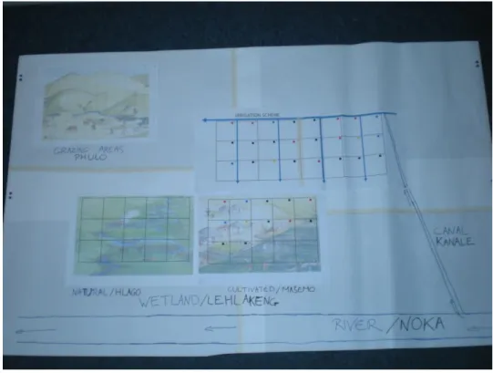
At present, the game spatial structure includes four A3 sheets representing the main elements of the ecological and socio-economic system of the Ga-Mampa valley (see Figure 4):
- an irrigation scheme divided into plots allocated to different types of farmers;
- the wetland, also divided into plots with a section already cultivated and allocated to farmers and a section where the natural vegetation is used for livestock grazing and collecting plants for building and crafting;
- range lands that can be used for grazing8.
The game board also displays the Mohlapitsi river, of which the Ga-Mampa wetland is riverine, and the irrigation canal that withdraws water for the irrigation scheme (see Figure 3). Initially, it also included the shallow aquifer linked to the wetland but this feature was abandoned later for sake of simplicity. This structure has been designed such that it can be adapted to represent other
situations.
Figure 3: Wet-WAG game board
8
Pictures represented on the game board were taken from Windows on our World : Wetlands, an educational package developed by the Wetland Alliance for Training, Education and Research (W.A.T.E.R.), the Mondi Wetlands Project, WESSA (the Wildlife and Environment Society of South Africa), the Department of Water Affairs and Forestry and the Department of Agriculture.
Figure 4: Landplots of Wet-WAG.
5.4 Roles, activities, tokens
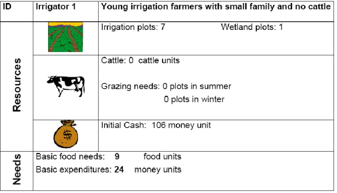
Six roles, each representing a farming household, are present in the game. Roles differ by their resources endowment (in terms of land in the irrigation scheme and wetland, livestock, and initial cash) and livelihood needs (food, cash and grazing area). A role card summarises this information (Figure 5).
Figure 5: Example of a role card
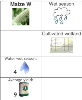
Activity cards (Figure 6) give information on activities that can be performed on each type of land.
Each activity is characterised by its season, where it can be done (irrigation scheme, cultivated wetland, natural wetland, range land), and its water requirements (and optionally costs and manpower requirements). The activity cards also provide information on the maximum yield (self consumption activity) or revenue (income raising activity) which can be attained when water requirements are met. Players show the activities they have chosen by placing activity tokens on their plots (Figure 7).
In the very first version of the game, players were endowed with units of manpower. During the game they had to allocate these units to their various activities. The first test session showed that the introduction of this additional resource did complicate the game and delayed decisions as players had to handle too many resources. Focus group discussions with local farmers confirmed that manpower is rarely seen to be a constraint; they can have workers when they need it, even during periods of intensive work such as the harvest. Therefore we decided not to use manpower in the game and the role cards were simplified accordingly.
Blue beads of different sizes represent different units of water (Figure 8). The game manager makes them circulated in the system (see next section) from the river to the irrigation scheme and the wetland. Farmers receive water in three different ways:
Water from the irrigation scheme: 6 water units are available for each secondary canal in wet season, only 3 during dry season.
Rainwater occurs only during wet season. Its quantity (from 0 to 3 water units) depends on the climate of the year (very dry year, dry year, wet year, very wet year) (see Figure 9). Groundwater is not physically represented in the game, but players are informed that
groundwater provides enough water for the crops in the wetland. There is no supply of groundwater in the irrigation scheme.
Figure 6: Example of an activity card
Figure 7: Examples of activity tokens
(Picture: F. Milhau, 2010)
(Picture: F. Milhau, 2010)
Figure 8: Water units and money units during a game session
Small beads (1 water unit)
Medium beads (10 water units)
Figure 9: Rainfall water depends on the season and the specific conditions of the year
Water feeds the crops planted by each player on his/her plots. The player can only get the optimum yield indicated on the action card, if the plot receives the number of water units indicated. The game also represents water losses due to the canal poor condition. At the beginning of the session, the game manager explains the water circulation from the river to the irrigation scheme and makes clear that 90% of the water is lost through leakages and bad design of the canal.
Farmers receives pay-off from their activities in the form of cash (bank notes, see Figure 8) or food (food tokens, see Figure 10).
Figure 10: Food tokens
Event cards are designed to bring unexpected events to the players (environmental events such as
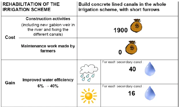
floods, economic events such as variation of prices) or management solutions supported by governmental policies. Usually one card can be drawn per year and per player. Event cards can either affect some particular players or have an impact on all players. The first two event cards designed represent respectively the rehabilitation of the gravity irrigation scheme (Figure 11) and its transformation into a sprinkler irrigation system (Figure 12). Other event cards were developed for the use of Wet-WAG to support the participatory multi-criteria analysis (see section 8).
The first card offers players the possibility to save some money in order to pay for the rehabilitation of the gravity irrigation scheme. The main features would be building a new intake of water in the river and cementing every canal in the system. The economic and technical data used are based on a report from a consulting company on the rehabilitation of one of the irrigation schemes in the Ga-Mampa valley (Munyai Malaka Engineers 2005). One can see that the increase of irrigation efficiency would solve water shortages during the winter. Each plot would get at least two units of water during winter, thus allowing players to plant more crops in the irrigation scheme.
Figure 11: Event card “Rehabilitation of the irrigation scheme”
The second card (Figure 12) was designed following a focus group discussion, during which some farmers mentioned they would like to use sprinklers for irrigation rather than their traditional gravity system. Thus, we thought it could be interesting to offer players the choice between the two systems. Activities would include the installation of a pumping station and installation of pipes to carry water under pressure from the river to the scheme. Unlike the previous system, this one would require external maintenance and running costs (electricity). Figures included in the card are very rough assumptions and require further investigation to be more realistic. According to Munyai Malaka Engineers’ report, irrigation efficiency could reach 70%. However, this system requires heavy
maintenance, and is new for the farmers, thus there would be a period of adaptation. In the game, this is represented by a progressive improvement of the irrigation efficiency: the first season, efficiency would rise to 20%, then 30% and at last 50%.
Figure 12: Event card “Building a new irrigation system”
5.5 Monitoring material
Individual monitoring sheets can be used by players to record the water received and their pay-off at each round (see Annex 2). These sheets are useful for recording what happened during a session and supporting the debriefing session. However, they are not always easy to use by players with low level of literacy. This manual monitoring sheet was transferred into an Excel spreadsheet later on to allow a quicker computation of pay-off at the end of each round (see section 8).
A monitoring table was developed to stress the environmental consequences of socio-economic decisions of players. It is used to show some indicators of the state of the wetland system (number of wetland plots under cultivation, grazing and natural vegetation). Its principles are described in Box 1. The scores used in the monitoring sheet are arbitrary, but reflect the magnitude of the impact of each type of use. They are based on Kotze’s report on the ecological assessment of the Ga-Mampa wetland (Kotze 2005), as well as on the WET-Health tool developed to assess the ecological status of wetland (Macfarlane et al. 2008).The limits set for the wetland score were also roughly derived from the same documents. A wetland score of 30 represents around one third of the plots cultivated along with some cattle grazing, which is not expected to excess the carrying capacity of the
ecosystem. Five levels of ecological status of the wetland were described along with their
consequences (see Box 2). The wetland health monitoring sheet was also integrated into the Excel sheet.
Wetland health record
How to use this tool:
For each season, the game manager writes down the number of plots used in the wetland for each of the mentioned land use.
Then, the game manager multiplies the number of plots used for each action with the score of this action. The result is the « action score ». If the « action score » is lower than 5, it is lowered to 0.
Finally, the three « action scores » are added to get the « wetland score » for the season.
if the wetland score of the season is lower than 30, the wetland health improves of
one level
if the wetland seasonal score is comprised between 30 and 50, the wetland health
stays at its previous level
if the wetland seasonal score is higher than 50, the wetland health degrades of one
level.
The condition at the beginning of the session should be the “baseline condition”, though this could be adapted to suit the local situation.
Action
Crop
(Maize, Tomato...)
3 points
Cattle
2 points
Plant harvesting
(reeds, sedges)
1 point
Number
of plots
Action
score crop
Number
of plots
Action
score
cattle
Number
of plots
Action
score
harvesting
Wetland
score
Example 4 12 7 14 3 0 26Season 1
Season 2
Season 3
Season 4
Season 5
The various wetland conditions and their consequences
Wetland condition
Description of the wetland
condition
Consequences
Highly degraded
Over-working of soil is depleting
the soil organic matter
Erosion is rapidly degrading the
banks of the river and the plots
Removal of indigenous vegetation
causes large losses of species
Draining of soil deeply affects the
groundwater level
All crops yields or revenues
are lowered by one level on
the production table
Reeds and sedges can be
harvested on 5 plots only
2 more plots are unusable in
the cultivated wetland
Degraded
Erosion occurs but at a limited
extent
Over-working of soil is affecting the
soil organic matter
Indigenous vegetation tends to
disappear
Reeds and sedges can be
harvested on 10 plots only
3 plots in the cultivated
wetland are unusable due to
lack of organic matter
Water quality is degrading
and the municipality imposes
a fine of 10 money units to
each farmer
Baseline condition
Cropping systems tend to
overpower natural vegetation
Hydrology is slightly affected
None, yields and water
requirements are at their
initial level
Upgraded
A right balance is found between
cropping and preservation of
undisturbed patches of natural
vegetation
Soils water content is improved
Yields and revenues are
increased by one level
compared to the baseline
condition
Highly upgraded
Natural vegetation is dramatically
expanding throughout the wetland
Soil organic matter is at its highest
Fauna benefits from large
undisturbed areas of natural
vegetation
Soils have a high water content
Reeds and sedges can be
harvested in the formerly
cultivated parts of the wetland
As water quality has
improved, the municipality
accepts to help funding
collective investments
Box 2: Wetland conditions designed for Wet-WAG
Consequences listed in box 2 are a transposition into the game of real life consequences listed in WET-Health (Macfarlane et al., 2008). They are supposed to make players aware of the
environmental consequences of their actions. Of course, the time scale has been reduced to fit the game time frame. Soil organic matter depletion does not occur in one season (6 months) but over
the course of several years. Among the consequences, some are the result of the game designers’ decision. As an example, the fine of 10 money units for poor water quality is not planned by the Municipality or any other stakeholder.
6 A typical game session
6.1 Game process
The game facilitator explains the game to the players by introducing the different components step by step: the game board, the circulation of water and succession of seasons, the roles and activities. Role cards and activity cards are distributed to the players and their content is detailed. Initial cash is distributed.
The game is played at a seasonal step, with an alternation of wet and dry seasons. Each season, players must feed their family, pay for their basic costs and choose the activities they perform on their plots: cultivation, grazing, natural plant collection (in some sessions, they also had to pay the corresponding seasonal costs and affect manpower to them).
The first round (usually a rainy season) starts with the provision of information on the yearly situation (expected climate, policy and management rules, and objectives). Each player chooses the activities he/she wants to undertake on his/her plots. Once players have chosen their activities, the seasonal water (rain water, water withdrawn from the river, groundwater) is run by the water manager (or game facilitator) and distributed to the plots. Players who have access to the irrigation scheme share irrigation water among them. This step generally gives rise to intense discussions among players. Other points generating discussion include the use of unallocated plots in the wetland or the presence of livestock around cropping fields. Then players receive their gains according to the activities they chose and the water they got on their plots. An assessment of the wetland state is recorded on the monitoring table. When the wetland is degraded, crop yields or harvest of natural products are reduced with impact on players pay-offs. Some plots in natural or cultivated wetland can even be “blocked” so that no human activity can be undertaken. The game then moves to the next round.
6.2 Game devices used to trigger collective discussion
Several kinds of “devices” can be used during the game to trigger discussion about wetland management issues:
- General rules of the game, such as the fact that irrigation farmers have to share irrigation water among themselves
- Wetland monitoring sheet: discussion can either happen during the game at the end of each round, to decide collectively upon the use of the wetland in the following round or during the debriefing after the session. This was done for example during the last testing session in Ga-Mampa. It made farmers aware of some of the consequences of over-cropping and they started discussing on how to control what farmers are doing in the wetland.
- Event cards: the cards on irrigation schemes rehabilitation can be used by the game facilitator during the course of the game, after one or two seasons. Players need to realize first how scarce the water is in the system. Then, they can decide to save some money, and to contribute to the cost of the irrigation rehabilitation. The mode of contribution has to be decided among players: who will participate (every player, only irrigation farmers), how much will each farmer give… There are several interests. As the game is a representation of the reality, external stakeholders would realize the need for a better irrigation system in Ga-Mampa. Then, it would allow farmers and/or representatives from the administration to discuss which option would be better, whether rehabilitating the existing gravity system or building a new pressurized system. Discussions during the game and the debriefing can provide room for players to think on this issue and help them make decisions about Ga-Mampa real resources management.
6.3 Debriefing
Debriefing is an essential part of the use of role-playing game in natural resources management and should not be overlooked. There are two main components of the debriefing: the first one is about the game itself: What works or not? What is difficult to understand? What is pleasant or not? This first part was very useful during the testing sessions to improve the game design.
The second component consists in helping participants commenting on their role in the game and reflecting on their role in the real life. This discussion is part of a collective learning process and can help further discussion in the real life, because participants can refer to it later. The following questions can guide the discussion of this second component:
- Did some of you feel bad during the game?
- What happened during the game? What are the key features? What can you take from it? - Do you think that this kind of situation can happen in real life?
- Is there anything unrealistic in the game or something missing?
- We agreed that some changes need to happen in the reality. How can we commit for it? In the testing sessions organised in France, West Africa and South Africa, the discussion around the game itself was based on the evaluation form (see Annex 3) filled by individual players, followed by a collective discussion. The discussion comparing the game and the reality occur mainly during sessions organised in South Africa with participants from villages, especially the last session organised in Ga-Mampa.
7 Results
Results of the first test sessions showed that the game is well received and can be played by a wide range of people (students, researchers, local community members, water management professionals). Most participants found it funny, interesting and educational. Some improvements are however needed, especially regarding the length of the sessions, the clarity of game rules and the scenarios played. Further developments of the game could include the introduction of new roles (e.g., regulator), external events triggering discussion around specific issues of interest, and representation of other wetland ecosystem services (e.g., flood retention) to increase the genericity of the game. Another version of the game representing the interaction between the wetland management and river basin management would also be useful. Some of these aspects are discussed in the following sections.
7.1 Roles in Wet-WAG: relevance and additions
Roles in Wet-WAG are limited to farmers. First tests of the game prototype prompted questions about the representativeness of the existing roles and the need for additional ones.
The typology of farmers used in Wet-WAG was based on typologies developed during previous research in the area (Chiron 2005, Masclet 2007). It is based on the following characteristics:
Access to land (irrigation scheme and/or wetland) Number of cattle
Basic food needs (related to the family size)
Basic expenditures (related to the family size, but also to the external incomes provided by family members working outside the village and social grants).
During the meetings in Ga-Mampa, roles were presented and great care was used to explain the differences between them. Every time, participants agreed and confirmed that the diversity of roles resembles what exists in Ga-Mampa and that these characteristics are indeed important to classify farming households. In addition they said that there was no significant category of household overlooked by the game.
No additional role was developed during the design process, although some thought were given to adding roles for regulators in charge of keeping rules, such as traditional leader, or external regulator representing the interests of other stakeholders such as the Department of Environment, the
Department of Water Affairs or the Municipality. The absence of regulator in the game mimics the reality where traditional authorities are loosing their hold on wetland management and control from external regulators remains very weak. The game facilitator plays the regulator in the current version of the game, but it could be interesting to make someone else play this role.
7.2 Developing new action cards
During the development of the game in South Africa, new actions cards were introduced to diversify the choices of farmers and make the game more interesting. This was based on previous research done in the area (e.g., Chiron 2005) and interviews of local stakeholders (e.g., the extension officer). Crops identified in the village include:
Dry beans during the dry season, cultivated in the irrigation scheme
Groundnuts, during the wet season, in the irrigation scheme and the wetland Sweet potatoes, during the wet season, only in the irrigation scheme