HAL Id: hal-00301593
https://hal.archives-ouvertes.fr/hal-00301593
Submitted on 1 Jan 2001
HAL is a multi-disciplinary open access
archive for the deposit and dissemination of
sci-entific research documents, whether they are
pub-lished or not. The documents may come from
teaching and research institutions in France or
abroad, or from public or private research centers.
L’archive ouverte pluridisciplinaire HAL, est
destinée au dépôt et à la diffusion de documents
scientifiques de niveau recherche, publiés ou non,
émanant des établissements d’enseignement et de
recherche français ou étrangers, des laboratoires
publics ou privés.
Hydrological anomalies connected to earthquakes in
southern Apennines (Italy)
E. Esposito, R. Pece, S. Porfido, G. Tranfaglia
To cite this version:
E. Esposito, R. Pece, S. Porfido, G. Tranfaglia. Hydrological anomalies connected to earthquakes in
southern Apennines (Italy). Natural Hazards and Earth System Science, Copernicus Publications on
behalf of the European Geosciences Union, 2001, 1 (3), pp.137-144. �hal-00301593�
Natural Hazards and Earth System Sciences (2001) 1: 137–144 c
European Geophysical Society 2001
Natural Hazards
and Earth
System Sciences
Hydrological anomalies connected to earthquakes in southern
Apennines (Italy)
E. Esposito1, R. Pece2, S. Porfido1, and G. Tranfaglia3
1Consiglio Nazionale delle Ricerche, Geomare sud, Via Vespucci 9, 80142 Napoli, Italy
2Dipartimento di Scienze della Terra, Universit`a di Napoli Federico II, Largo S. Marcellino, 10, 80138 Napoli, Italy
3Servizio Idrografico e Mareografico Nazionale, Compartimento di Napoli, Via Marchese Campodisola 21, 80133 Napoli,
Italy
Received: 14 May 2001 – Revised: 27 September 2001 – Accepted: 17 October 2001
Abstract. The study of hydrological variations in the wa-tersheds of seismic areas can be useful in order to acquire a new knowledge of the mechanisms by which earthquakes can produce hydrological anomalies. Italy has the availabil-ity of many long historical series both of hydrological param-eters and of seismological data, and is an ideal laboratory to verify the validity of theoretical models proposed by various authors.
In this work we analyse the hydrological anomalies asso-ciated with some of the big earthquakes that occurred in the last century in the southern Apennines: 1930, 1980 and 1984. For these earthquakes we analysed hydrometric and pluvio-metric data looking for significant anomalies in springs, wa-ter wells and mountain streams. The influence of rainfalls on the normal flows of rivers, springs and wells has been as-certained. Also, the earthquake of 1805, for which a lot of hydrological perturbations have been reported, is considered in order to point out effects imputable to this earthquake that can be similar to the effects of the other big earthquakes.
The considered seismic events exhibit different modes of energy release, different focal mechanisms and different propagation of effects on the invested areas. Furthermore, even if their epicentres were not localised in contiguous seis-mogenetic areas, it seems that the hydrological effects im-putable to them took place in the same areas. Such phe-nomena have been compared with macroseismic fields and transformed in parameters, in order to derive empirical rela-tionships between the dimensions of the event and the char-acteristics of the hydrological variations.
The results of this work point to a close dependence among hydrological anomalies, regional structures and fault mech-anisms, and indicate that many clear anomalies have been forerunners of earthquakes. In 1993, the Naples Bureau of the Hydrographic National Service started the continuous monitoring of hydrologic parameters by a network of auto-matic stations and transmission in real time; presently 7 ac-quifers are under control in which also pH, T , salinity, elec-Correspondence to: R. Pece (pece@unina.it)
trical conductivity, dissolved oxygen are measured. We en-visage to increase the number of monitoring sites and con-trolled parameters.
1 Introduction
Information on hydrological variations associated with seis-mic events (anomalies, such as increase or decrease of spring and river flows, the rising or lowering of the water level in wells) concomitant and/or preceding seismic events
has been widely known for at least 2000 years. In the
last decades some hydrological anomalies have been used as earthquake precursors (Savaresky and Rikitake, 1972; Scholtz et al., 1973; Rikitake, 1974, 1975; Whitehead et al., 1985; Chengmin, 1985; Mogi, 1987; Kissin and Grinevsky, 1990; Igarashi et al., 1992). One of the best examples is the Haicheng earthquake in 1975, when a lot of hydrological anomalies occurred before the earthquake and the city was then evacuated (Molnar et al., 1976).
Also in Italy, a possible correlation between earthquakes and piezometric anomalies has been recognised (Albarello et al., 1991; Albarello and Martinelli, 1994; Onorati and Tranfaglia, 1994; Onorati et al., 1994; Pece et al., 1999; Es-posito et al., 1998a, 1999). Many other documents of the XVIII and XIX centuries report information regarding vari-ations of water levels and spring flows in occurrence with earthquakes.
Only in the last two decades have the hydrological vari-ations been related to the characteristics of seismic sources. Various interpretative models (Gold and Soter, 1985; Brede-hoeft et al., 1987; King and Muir-Wood, 1993; Muir-Wood and King, 1994; Briggs, 1994; Curry et al., 1994; Rojs-taczer and Wolf, 1994) indicate how the fluctuations of the water level in wells and the variations in the flow of springs and/or mountain rivers can be used as earthquake precursors and, moreover, to characterise the mechanisms of the seismic source, because they are significantly influenced by the de-formation field associated with the earthquake. In particular,
138 E. Esposito et al.: Hydrological anomalies connected to earthquakes in southern Apennines (Italy)
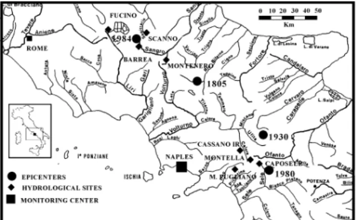
Fig. 1. Sketch map of southern Italy illustrating the Monitoring Center in Naples and the mentioned hydrological sites. Also, the four epicenters of the studied earthquakes are indicated.
King and Muir-Wood (1993) recently proposed a model of the deformation associated with the dislocation phenomena in complex systems of faults with different mechanisms and orientations. According to this model, the coseismic disloca-tion during strong earthquakes produces a notable deforma-tion of the superficial crust (surface layers) which influences directly the superficial acquifers. Therefore, the hydrological regime and the spatial variation of anomalies are correlated to the spatial variation of the volumetric deformation pro-duced by the phenomena of the coseismic dislocation in a wide area.
Furthermore, some authors tried to classify the possible “shapes” of the hydrological anomalies and to find some relationships among magnitude, precursor time and dis-tance from epicentre of the hydrological anomalies. Kissin and Grinevsky (1990) examined carefully many hydrologi-cal anomalies reported in various parts of the Earth. Also, Chengmin (1985) examined many anomalous variation pre-cursors of 60 earthquakes with M > 6.0 in China. They found essentially that: (1) most of these anomalies took place at distance less than 50 km from the epicentres; (2) their number decreases rapidly at a growing distance from the epi-centre; (3) the type or the “shape” of the anomaly depends on the fault type, topography, magnitude and distance from the epicentre, the time before and/or after the earthquake. Kissin and Grinevsky (1990) classified some typical shapes of hy-drological anomalies: 57% of the anomalies consist of a gen-eralized depression of groundwater levels, 24% and 12% are stepwise increases and decreases, respectively, of groundwa-ter levels, and 7% are complex variations. The groundwagroundwa-ter level variations can be 0.5 cm–16 m, but 76% are comprised between 1 cm and 1 m.
Also many hydrological variations were reported by Ro-jstaczer and Wolf (1994) for the Loma Prieta earthquake in 1989: groundwater levels in the highland parts of the drainage basins were lowered for a long time, while most of the streamflow increased within 15 min after the earthquake, indicating that the earthquake increased the rock
permeabil-ity and temporarily enhanced groundwater flow rates. In 1993, the Naples Bureau of Hydrographic National Service started the continuous monitoring of hydrologic parameters by a network of automatic stations in real time transmission. This network (Tranfaglia, 1994; Onorati and Tranfaglia, 1996) consists of 82 stations, 7 repeaters and the acquisition Centre in Naples, controlling a total of 175 sensors (26 ultra-sonic hydrometers on bridges, 63 rain gauges, 23 thermome-ters, 13 hygromethermome-ters, 5 baromethermome-ters, 4 anemomethermome-ters, 6 water level gauges). All the data from the sensors are transmitted at the Monitoring Centre in Naples where they are contin-uously controlled, visualised and stored (Fig. 1). We hope that this monitoring can furnish clearly the evidence that hy-drological anomalies are forerunners of earthquakes in the controlled areas.
2 Earthquakes in southern Apennines
The areas considered in this work constitute nearly all of the southern part of the Apennine Chain from the Molise Re-gion to the Lucania (Basilicata) ReRe-gion. The seismicity in this section of the Apennine Chain is characterised by severe seismic events with intensities greater than IX MCS. In this work we analyse the hydrological anomalies associated with some of the strong earthquakes that occurred in the last cen-turies in southern Apennines:
– 1984 (Southern Abruzzo, 7–11 May) – 1980 (Irpinia-Basilicata, 23 November) – 1930 (Irpinia, 23 July),
– 1805 (Molise, 26 July).
For the most recent earthquakes (1980 and 1984), we anal-ysed hydrometric and pluviometric data from 1972–1992 looking for significant anomalies in springs, water wells and mountain streams. The influence of rainfalls on the normal flows of rivers, springs and wells has been statistically veri-fied. With regards to the older earthquakes (1805 and 1930), we considered the historical sources contemporaneous to the seismic event and we could classify types and entities of hy-drological phenomena strictly imputable to the earthquake.
The considered seismic events show different modes of en-ergy release, different focal mechanisms and different prop-agation of effects on the invested areas. Furthermore, even if their epicentres were localised in seismogenetic, and not the contiguous areas, it seems that the hydrological effects imputable to them took place in the same areas.
Such phenomena have been compared at first with macro-seismic field and subsequently transformed in parameters, in order to derive empirical relationships between the dimen-sions of the event and the characteristics of the hydrological variations.
The first results of this work point to a close dependence among hydrological anomalies, regional structures and fault mechanisms.
E. Esposito et al.: Hydrological anomalies connected to earthquakes in southern Apennines (Italy) 139 23 July 1930 earthquake 18 Jul 23 Jul 25 Jul 0 5 10 15 20 25 01 J un 05 J un 09 J un 13 J un 17 J un 21 J un 25 J un 28 Jun 03 J ul 07 J ul 11 Ju l 15 Ju l 19 Ju l 23 J ul 27 Ju l 31 J ul 04 Aug 08 Aug 12 Aug 16 Aug 20 Aug 24 Aug 28 Aug D aily r ainf all (m m ) 4 6 8 10 12 14 16 18 20 D aily st re am flow l ev el ( cm )
Daily rainfall at S. Domenico Streamflow level of Tasso river at Scanno
Fig. 2. Hydrological anomaly correlated to the 23 July 1930 earth-quake, consisting of a sharp decrease a few days before the seismic event followed by a strong increase of the streamflow level of the Tasso River measured at Scanno.
3 Discussion
3.1 The Molise earthquake of July 1805
The 26 July 1805 earthquake happened inside the Molise seismogenetic zone (Alessio et al., 1993), where various strong earthquakes (greater than X MCS) took place, like those in 346, 848 and December 1456. At present, the seis-micity is constituted by low magnitude swarms, like the
se-quence at Isernia in January 1986, with Mmax=4.0 and that
of Sannio-Matese in March 1997 with Mmax=4.6 (Alessio
et al., 1990).
This strong earthquake was felt in all of southern Italy and damaged more than 200 cities and villages in the Molise and Campania regions. The macroseismic epicentre is localised in the Molise zone, between Isernia and Campobasso; the highest intensity of XI MCS was at Frosolone (Isernia dis-trict). The effects of this earthquake before, during and af-ter the main shock are particularly inaf-teresting. We collected the descriptions of a lot of phenomena possibly linked to the seismic event; in fact, starting from the XVII century, the interest of naturalists to analyse and interpret the seismic phenomenon, and also the attention on the effects of earth-quakes, increased; as a consequence, both the number of reports and the accuracy in the descriptions of strange phe-nomena grew considerably. The many historical sources al-low one to understand and point out types and entities of the phenomena directly imputable to this earthquake. Fractures, landslides, liquefaction, hydrological variations in springs, rivers and wells are distributed in the area of VII MCS. The details in the descriptions of the earthquake’s effects allow one to distinguish a temporal succession of such effects: in particular, in the phase preceding the earthquake, variations of hydrological parameters, flow rate and chemical compo-sition in some localities in Molise have been reported; be-sides the hydrologic variations (anomalies), other numerous coseismic effects have been observed: ground effects, as fractures and landslides (Esposito et al., 1987, 1995, 1998b; Michetti et al., 2000). Flow increases have been observed
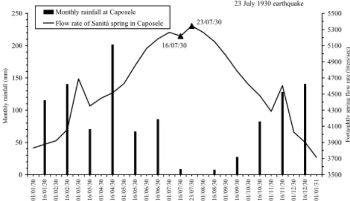
23 July 1930 earthquake 23/07/30 16/07/30 0 50 100 150 200 250 01/01/30 16/01/30 01/02/30 16/02/30 01/03/30 16/03/30 01/04/30 16/04/30 01/05/30 16/05/30 01/06/30 16/06/30 01/07/30 16/07/30 23/07/30 01/08/30 16/08/30 01/09/30 16/09/30 01/10/30 16/10/30 01/11/30 16/11/30 01/12/30 16/12/30 01/01/31 M onthly ra in fa ll (m m ) 3500 3700 3900 4100 4300 4500 4700 4900 5100 5300 5500 Fortnightly sp ring flow r ate (lit er s/ se c)
Monthly rainfall at Caposele Flow rate of Sanità spring in Caposele
Fig. 3. Hydrological anomaly correlated to the 23 July 1930 earth-quake, consisting of an increase in the flow rate of Sanit`a Spring at Caposele of about 150 l/s.
in more than 16 springs, mostly SSW of the Matese Moun-tains. Contemporaneously, 4 new springs appeared at S. Sal-vatore Telesino (Caserta district), Morcone (Benevento dis-trict), Matese Mountains and Boiano (Campobasso district). The new spring in Boiano was active for about 2 months after the seismic event.
3.2 The earthquake of July 1930
The 23 July 1930 earthquake, erroneously defined as “the Vulture earthquake”, destroyed almost entirely many villages in Eastern Irpinia, causing severe damages also in the Ben-evento, Foggia and Potenza provinces. The victims were more than 1400 and the wounded were about 10 000. The main shock happened at 00:08 GMT with the greatest inten-sity of X MCS and a magnitude Ms = 6.7, followed by many aftershocks, some of which with intensity of VII MCS. Nu-merous and impressive phenomena on the physical environ-ment were observed in the villages of Andretta, Aquilonia, Ariano Irpino, Bisaccia, Calitri, Flumeri, Melfi, Trevico, San Giorgio la Molara, Vallata, Villanova del Battista and Zun-goli.
To reconstruct the effects on the environment caused by this strong earthquake, we started to: (1) research methodi-cally all the documents relative to it; (2) to analyse critimethodi-cally the administrative and technical reports in the Record Offices and in Civil Engineer Offices of Avellino and Salerno cities and in the Municipal Technical Offices of the towns around the epicentre. Furthermore, all the information from local and national newspapers have been collected.
The critical examination of the seismological knowledge at that time completed this investigation in order to better un-derstand the collected information. The comparison between the bibliographic sources and the unpublished reports al-lowed us to draft the map of the coseismic geological effects: landslide phenomena, hydrological anomalies, soil fractures and surficial tectonic breaks.
This investigation revealed that the greatest number of the seismic effects were found in the isoseismic area of VIII MCS (Esposito et al., 2000; Porfido et al., 2001). Two
hy-140 E. Esposito et al.: Hydrological anomalies connected to earthquakes in southern Apennines (Italy) drological anomalies are shown in Figs. 2 and 3 for the Tasso
River and one spring at Caposele.
In Fig. 2 the hydrological anomaly correlated to the 1930 earthquake consists of a sharp decrease in the streamflow a few days before the seismic event, even if high rainfalls preceded this decrease. Also, the increase after the seismic event seems to be an anomalous hydrological behaviour of the springs that contribute to the Tasso River.
In Fig. 3 an increase of 150 l/s in the flow rate of Sanit`a Spring at Caposele was noted in the measurements carried out a few hours after the seismic event with respect to the measurements carried out on 16 July 1930, a week before the earthquake.
3.3 The earthquake of November 1980
The 23 November 1980 earthquake happened inside a seis-mically active band extending from southern Abruzzo to Lu-cania (Basilicata). This Campanian-LuLu-canian seismogenetic zone is characterised by a complex seismotectonic structure, buried under the thick alloctonous terrains that constitute the Apennine Chain.
On the basis of geological, structural and geophysical ev-idences, the seismogenetic band has been subdivided into more seismogenetic zones (Scandone et al., 1990; Alessio et al., 1993, 1995) characterised by a frequent seismicity, both historical as the earthquakes in 1561, 1694, 1851, 1857, 1930 with I ≥ IX MCS and recent, main shock-aftershock type, as the earthquakes in 1980, 1990, 1991 with I ≥ VIII and 5 ≤ M ≤ 6.9.
About 800 villages were damaged in Campania and Lu-cania. The Imax was X MSK. This great intensity and the nature of the geological structures caused very numerous
effects. Surface fractures were observed in all the areas
from the epicentre until to the VIII isoseismal line. About 200 landslide phenomena were observed in an area more
than 20 000 km2wide around the epicentre (Esposito et al.,
1998b).
The study of the hydrological effects has been carried out on:
– measurements of water levels in 9 wells with 3 days pe-riodicity;
– spring flows measured each day; – streamflow levels measured each day;
– continuous registration of water level in rivers.
We also considered many other similar, but less continu-ous measurements carried out during 1975–1985 (periodicity varied from weekly to monthly) on minor springs and rivers. Seven of the about 30 greatest springs exhibited a clear anomaly. Most of them are in the high Sele River and on Matese Mountains.
Before the earthquake, the trends of hydrometric levels were normal or decreasing, but showed a general increase
23 November 1980 earthquake 30/11/80 17/11/80 0,0 50,0 100,0 150,0 200,0 250,0 15/ 07/ 80 15/ 08/ 80 15/ 09/ 80 06/ 10/ 80 20/ 10/ 80 03/ 11/ 80 17/ 11/ 80 12/ 12/ 80 29/ 12/ 80 12/ 01/ 81 26/ 01/ 81 09/ 02/ 81 23/ 02/ 81 09/ 03/ 81 23/ 03/ 81 06/ 04/ 81 27/ 04/ 81 11/ 05/ 81 25/ 05/ 81 08/ 06/ 81 29/ 06/ 81 13/ 07/ 81 03/ 08/ 81 21/ 08/ 81 08/ 09/ 81 27/ 09/ 81 10/ 10/ 81 25/ 10/ 81 21/ 11/ 81 15/ 12/ 81 Fortnightly r ainf all (m m ) 0 10 20 30 40 50 60 Fortnightly flow r ate (lit er/ se c)
Fortnightly Rainfall (mm) at Pontecagnano Flow rate of Acqua Fetente Spring at Montecorvino Pugliano
Fig. 4. Hydrological anomaly correlated to the 23 November 1980 earthquake, consisting of a great increase in the flow rate of Acqua Fetente Spring at Montecorvino Pugliano from 14.7 to 50.8 l/s. This variation lasted for more than one year.
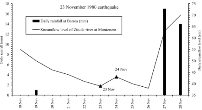
23 November 1980 earthquake 23 Nov 24 Nov 0 2 4 6 8 10 12 14 16 18 18 Nov 19 Nov 20 Nov 21 Nov 22 Nov 23 Nov 24 Nov 25 Nov 26 Nov 27 Nov 28 Nov D aily r ainf all (m m ) 35 40 45 50 55 60 65 70 75 D aily st re am flow l ev el ( cm )
Daily rainfall at Barrea (mm) Streamflow level of Zittola river at Montenero
Fig. 5. Hydrological anomaly correlated to the 23 November 1980 earthquake, consisting of an increase in the streamflow rate of Zit-tola River measured at Montenero, not imputable to rainfalls.
starting from 24 November, lasting for about 24–48 h. In some cases, the positive anomaly lasted until 27 November.
A detailed study of the spring flows at Caposele and Cas-sano Irpino, located near the epicentre, have been carried out, by considering the monthly averages in 10 years (Pece et al., 1999). The year 1980 appears to be hydrologically anoma-lous.
Figures 4 to 9 show some hydrological anomalies. In Fig. 4 the anomaly consists of the great increase in the flow rate of a thermal spring (Acqua Fetente) between 17 and 30 November (earthquake was on 23 November) and this in-crease lasted many months. All this behaviour is anomalous and the rainfalls could not produce such a sudden and great increase. It is sufficient to observe what is the contribution of each rainfall event on hydrograph of the flow rate. We suppose that the pre- and co-seismic stresses modified the groundwater circulation.
In Fig. 5 there is another type of anomaly. Measurements are carried out on the mountain stream by a river gauge and the continuous record shows that a decrease is followed by an increase recorded at 12:00 MLT each day. It is not possi-ble that this increase is due to some rainfall (no rainfalls are present in 23 and 24 November). The response of water level to rainfalls in this site is almost contemporaneous, because
E. Esposito et al.: Hydrological anomalies connected to earthquakes in southern Apennines (Italy) 141 23 November 1980 earthquake 25 Nov 24 Nov 23 Nov 0,0 5,0 10,0 15,0 20,0 25,0 30,0 35,0 40,0 45,0 18 N ov 19 N ov 20 N ov 21 N ov 22 N ov 23 N ov 24 N ov 25 N ov 26 N ov 27 N ov 28 N ov 29 N ov D aily r ai nf all at M on tema ra no ( m m ) 80 90 100 110 120 130 140 150 160 D aily s tr eam fl ow le ve l ( cm )
Daily rainfall (mm) at Montemarano Calore Irpino at Montella
Fig. 6. Hydrological anomaly correlated to the 23 November 1980 earthquake. In this case the streamflow level of Calore Irpino mea-sured daily at Montella decreased the day after the earthquake.
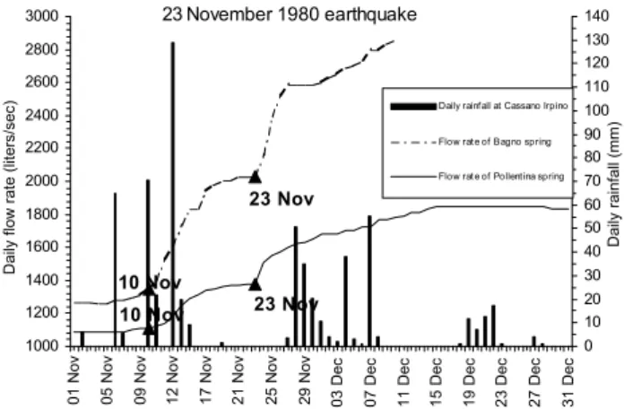
23 November 1980 earthquake 23 Nov 10 N o v 23 Nov 10 Nov 1000 1200 1400 1600 1800 2000 2200 2400 2600 2800 3000 01 N ov 05 N ov 09 N ov 12 N ov 17 N ov 21 N ov 25 N ov 29 N ov 03 D ec 07 D ec 11 D ec 15 D ec 19 D ec 23 D ec 27 D ec 31 D ec Da ily fl ow r ate ( lit er s/se c) 0 10 20 30 40 50 60 70 80 90 100 110 120 130 140 Daily rainf all (mm)
Daily rainfall at Cassano Irpino Flow rate of Bagno spring Flow rate of Pollentina spring
Fig. 7. Hydrological anomalies correlated to the 23 November 1980 earthquake consisting of the strong increase in the flow rate of Pol-lentina and Bagno Springs.
the catchment area of rainfall is small (see 27 November). So the increase between 23 and 24 November appears to be imputable only to the seismic event.
In Fig. 6 the anomaly seems to be the opposite of that shown in Fig. 5. In fact, there is a decrease from 23 to 24 November: the increase took place on 25–26 November. Also in this case, no rainfalls occurred in those days. The decrease at this site can be explained by taking into account that near Caposele Spring, the same behaviour is exhibited (Fig. 9).
Figure 7 shows the hydrological anomalies consisting of the strong increase in flow rate of Pollentina and Bagno Springs, very near each other at Cassano Irpino. It seems that this increase started about ten days before the seismic event. A further sharp increase took place soon after the earthquake. We retain that these increases cannot be im-putable to the rainfalls that preceded the seismic event. In fact, Fig. 8 shows the trends of monthly cumulated flow rates of these two springs compared to the rainfalls in the decade 1975–1985. This figure also reports the flow rate of the Ca-posele Spring. The lag among rainfalls and increases in the
Monthly rainfalls (dashed) and flow rates at Caposele and Cassano Irpino springs in 1975-1985
0 1000 2000 3000 4000 5000 6000 7000 8000 Jan 7 5 A ug 75 M ar ch 76 O ct 76 M ay 77 De c 77 Ju l 7 8 F eb 79 Sept 79 Apr 80 N ov 8 0 Ju n 81 Jan 8 2 A ug 82 M ar ch 83 O ct 83 M ay 84 De c 84 Ju l 8 5 F low rat e (lit ers /s ec ) 0 50 100 150 200 250 300 350 400 450 500 M on thly rain fa ll ( m m ) at C apo sele
Fig. 8. Monthly rainfalls (dashed) and flow rates at Caposele and Cassano Irpino Springs in 1975–1985 showing the lag between rain-falls and subsequent increase in flow rate.
23 November 1980 earthquake 25 Nov 23 Nov 24 Nov 0 5 10 15 20 25 30 35 40 45 50 01 Nov 04 Nov 07 Nov 10 Nov 13 Nov 16 Nov 19 Nov 22 Nov 25 Nov 28 Nov 01 Dec 04 Dec 07 Dec 10 Dec 13 D ec 16 Dec 19 Dec 22 Dec 25 Dec 28 Dec 31 Dec D aily r ainf all at C apo se le (m m ) 4000 4500 5000 5500 6000 6500 7000 7500 D aily sp ring flow r ate (lit er s/ se c)
Daily rainfall at Caposele Flow rate of Sanità spring in Caposele
Fig. 9. Hydrological anomaly correlated to the 23 November 1980 earthquake consisting of a small decrease in the spring flow rate the day after the earthquake, followed by a very great increase.
flow rates is consistent: some months, with Caposele preced-ing Cassano Irpino. This evidence has been already reported by many authors (Celico, 1981; Cotecchia and Salvemini, 1981).
In Fig. 9 the hydrological anomaly at Caposele consists of a small decrease in the spring flow rate the day after the earthquake, followed by a very great increase.
3.4 The earthquake of May 1984
The seismic sequence, which started in May 1984, consists of two main shocks, on 7 May and on 11 May with I = VII MSK in Southern Abruzzo, mainly in the National Park seismoge-netic zone (Alessio et al., 1993). The hypocentral depths are between 5 and 15 km. The seismic sequence terminated in October with a duration of about 5 months.
In order to evaluate the hydrological effects produced by the seismic sequence, we analysed the data registered in 15 hydrometrical stations and the variations of levels of two lakes (Barrea and Scanno), all localised in the epicentral area and monitored by the National Hydrologic Departments in Napoli and Pescara.
hydro-142 E. Esposito et al.: Hydrological anomalies connected to earthquakes in southern Apennines (Italy) 7 and 11 May 1984 earthquakes
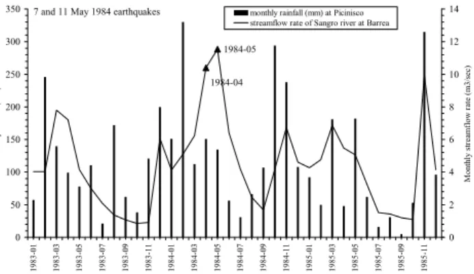
1984-05 1984-04 0 50 100 150 200 250 300 350 1983-01 1983-03 1983-05 1983-07 1983-09 1983-11 1984-01 1984-03 1984-05 1984-07 1984-09 1984-11 1985-01 1985-03 1985-05 1985-07 1985-09 1985-11 M onthly ra in fa l ( m m ) 0 2 4 6 8 10 12 14 M onthly st ream fl ow ra te (m 3/ se c)
monthly rainfall (mm) at Picinisco streamflow rate of Sangro river at Barrea
Fig. 10. Hydrological anomaly correlated to the May 1984 earth-quake consisting of an increase in the streamflow rate of Sangro River at Barrea, not imputable to the rainfalls. Data are monthly.
7 and 11 May 1984 earthquakes
8 6 7 0 5 10 15 20 25 30 1 2 3 4 5 6 7 8 9 10 11 12 13 14 15 16 17 18 19 20 21 22 23 24 25 26 27 28 29 30 31 D aily r ainf all (m m ) 40 50 60 70 80 90 100 110 120 130 D aily st re am flow l ev el ( cm )
daily rainfall in May at Avezzano streamflow level of Fucino at Pratofranco
Fig. 11. Hydrological anomaly correlated to the May 1984 earth-quake consisting of an increase in the streamflow rate of Fucino River at Pratofranco, not imputable to the rainfalls. Data are daily.
metric sections. Among them, 3 hydrometric stations WSW in the epicentral area, and another station located west of the continuation toward north of the Val di Sangro fault did not show notable hydrological anomalies in the days before the event of 7 May, while during all this month, flow rates were comparable with the average values calculated for the pe-riod 1979–1989, even if the rainfalls from January to May 1984 have been slightly higher than the average (Onorati and Tranfaglia, 1994).
Nevertheless, gas outpouring and the muddying of water have been noticed in the evening of 5 May, in the springs at Posta Fibreno, localized about 2 km before the hydrometric sections (Fibreno at Broccostella).
Also in the hydrometric section of the Sangro River at Ateleta, the hydrological anomaly was pointed out only in the value of the average streamflow level in May 1984. Con-sequently, for these earthquakes, we have a total of 14 sites where hydrological effects have been noticed, taking into ac-count that in 3 sites (the Rapido and Gari Rivers at Cassino, the Gari River at S. Angelo in Theodice), the positive hydro-logical anomalies preceded the earthquake of 7 May.
Figures 10 and 11 show the anomalous behaviour in two studied sites. In Fig. 10 we show an hydrological anomaly consisting of a strong increase in the streamflow rate of the Sangro River at Barrea, not imputable to the rainfalls.
Fig-ure 11 shows “a detail” of Fig. 10. The two sites are very near each other. It shows how during April 1984 the sharp increase of 7 May cannot be imputed to the very small rain-falls on 6 May. Data are daily.
4 Conclusions
In the southern Apennines we found that some earth-quakes produced forerunner signals in various areas where geochemical and hydrological parameters were controlled. These results seem to indicate that the hydrological phenom-ena are associated with the changes in the stress field, during and after an earthquake.
We analysed the relations of primary tectonic effects with the local geomorphic and structural setting. We also applied, for some categories of secondary effects, a statistical test to infer the presence of trends, and a regression analysis based on the least-squares method was performed.
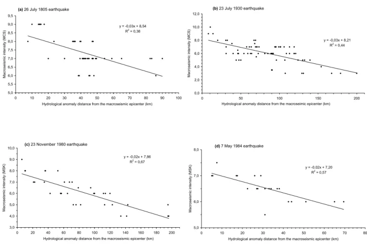
In particular, a simple bivariate scatter plot of two vari-ables has been computed, specifically: macroseismic in-tensities versus epicentral or fault distances of hydrological anomalies. Figure 12 shows, for each of the 4 considered earthquakes, the trend macroseismic intensity-distance from the epicenter of the hydrological anomalies we have found (30 for 1805 earthquake, 65 for 1930 earthquake, 35 for 1980 earthquake and 21 for 1984 earthquake). Very similar trends have been found for these earthquakes with a better fit for the two most recent earthquakes (1980 and 1984).
Hydrological phenomena occurred throughout the macro-seismic field, and were the most numerous among the in-duced effects. They include flow increase both in springs and wells, turbid water and drying up of springs, and even creation of new springs. Some variations in the chemical pa-rameters of the waters were observed at different locations, both inside and outside the epicentral areas.
The data relative to the hydrological variations’ distribu-tion versus the distance from the epicenter (Fig. 12) show the that the high concentration of phenomena (75%) lie between 25–80 km, whereas 19% were inside the epicentral area (0– 25 km); only 6% of these phenomena occurred at greater distances (about 100 km); this distribution is very similar to those reported by Kissin and Grinevsky (1990).
A dramatic increase in the springs’ flow implies the de-formation of a major tectonic block. A comparable phe-nomenon occurred at the Sanit`a Spring near Caposele during the 23 November 1980 earthquake.
A remarkable aspect of these anomalies is that they were observed at distances of several hundred kilometres from the earthquake epicentral area.
Figure 12 shows that much more data on hydrological changes are available for the 1980 earthquake compared to the 1805 earthquake. Even taking into account the better ac-curacy of the research conducted after the 1980 event, this suggests that the impact of the Irpinia earthquake on the hy-drogeological structure of the southern Apennines was more
E. Esposito et al.: Hydrological anomalies connected to earthquakes in southern Apennines (Italy) 143
(a) 26 July 1805 earthquake
y = -0,03x + 8,54 R2 = 0,38 5,0 5,5 6,0 6,5 7,0 7,5 8,0 8,5 9,0 9,5 0 10 20 30 40 50 60 70 80 90 100 Hydrological anomaly distance from the macroseismic epicenter (km)
M a cr o se ism ic in te n sity ( M CS) (b) 23 July 1930 earthquake y = -0,03x + 8,21 R2 = 0,44 0,0 2,0 4,0 6,0 8,0 10,0 12,0 0 50 100 150 200 Hydrological anomaly distance from the macroseimic epicenter (km)
M a cr o se ism ic in te n sity ( M CS) (c) 23 November 1980 earthquake y = -0,02x + 7,86 R2 = 0,67 3,0 4,0 5,0 6,0 7,0 8,0 9,0 10,0 0 20 40 60 80 100 120 140 160 180 200 Hydrological anomaly distance from the macroseismic epicenter (km)
M a cr o se ism ic in te n sity ( M SK) (d) 7 May 1984 earthquake y = -0,02x + 7,20 R2 = 0,57 5,0 6,0 7,0 8,0 0 10 20 30 40 50 60 70 80 Hydrological anomaly distance from the macroseismic epicenter (km)
M a cr o se ism ic in te n sity ( M SK)
Fig. 12. The figure shows for each earthquake the distance from epicenter and intensity (MCS or MSK) of the sites where hydrological anomalies have been observed. A clear negative linear regression is visible. For the 1930 (M = 6.5) and 1980 (M = 6.8) earthquakes the two trends are parallel.
important, in terms of both the total number of recorded anomalies and for their epicentral and fault distance.
Today, there are no valid earthquake precursors, but many effects are invoked as good forerunners: geophysical changes
(vp/vs, telluric currents, electromagnetic effects),
geochem-ical changes (chemgeochem-ical composition, pH, water temperature,
gases like Rn, CO2) and hydrological changes (piezometric
levels, spring and stream flow).
In this work we show hydrological anomalies for the con-sidered Italian earthquakes similar in “form and type” to those reported by previous authors in other regions of the Earth. They are examples of the many anomalies we have chosen for the considered earthquakes (see Fig. 12) and show how hydrological anomalies are made. Probably the simulta-neous observation of all of these effects can constitute a sure forecasting. Many efforts and money are necessary for this purpose.
Taking into account that earthquakes are not always pre-ceded by all of the above mentioned precursory phenomena, and that today’s technology can provide probes for many geochemical and geophysical parameters at an affordable cost, we maintain that a regional monitoring network can be installed in order to continuously control as many parameters as possible.
The presence of an already installed hydrological network
at the Hydrographic National Service in Campania can fur-nish a valid occasion to increase the number of parameters to monitor water tables and springs.
We envisage that the proposed improvement of this net-work can reveal many and contemporaneous anomalies in the trends of the monitored parameters; the examination of trends and anomalies are fundamental in order to produce a valid model of the interaction between stress fields and hy-drological behaviour in the monitored areas; this model can be considered reliable in order to verify the occurrence of pre-seismic anomalies.
References
Albarello, D. and Martinelli, G.: Piezometric levels as possible geo-dynamic indicators: analysis of data from a regional deep waters monitoring network in northern Italy, Geoph. Res. Lett., 21, 18, 1955–1958, 1994.
Albarello, D., Ferrari, G., Martinelli, G., and Mucciarelli, M.: Well level variation as a possible seismic precursor: a statistical as-sessment from Italian historical data, Tectonophysics, 193, 385– 395, 1991.
Alessio, G., Godano, C., and Gorini, A.: A low magnitude seismic sequence near Isernia (Molise, central Italy) on January 1986, PAGEOPH, 134, 2, 243–260, 1990.
144 E. Esposito et al.: Hydrological anomalies connected to earthquakes in southern Apennines (Italy) Alessio, G., Esposito, E., Gorini, A., Luongo, G., and Porfido S.:
Identification of seismogenic areas in the southern Apennines, Italy, Annali di Geofisica, 36, 1, 227–235, 1993.
Alessio, G., Esposito, E., Gorini, A., and Porfido, S.: Detailed study of the Potentino seismic zone of the southern Apennines, Italy, Tectonophysics, 250, 113–134, 1995.
Bredehoeft J. D., Riley F. S., and Roeloffs E. A.: Earthquakes and Groundwater. Earthquakes and Volcanoes, 19, 4, 142–146, 1987. Briggs, R. O.: Effects of the earthquakes on surface waters in Waddell Valley. In: The Loma Prieta (California) Earthquake of 17 October 1989 – Hydrologic disturbances, USGS Prof. Paper 1551–E, 21–30, 1994.
Celico, P.: Relazioni tra idrodinamica sotterranea e terremoti in Irpinia (Campania), Rendiconti Societ`a Geologica Italiana, 4, 103–108, 1981.
Chengmin, W.: Ground-water studies for earthquake prediction in China, Pageoph, 122, 215–217, 1985.
Cotecchia, V. and Salvemini A.: Correlazione fra eventi sismici e variazioni di portata alle sorgenti di Caposele e Cassano Irpino, con particolare riferimento al sisma del 23 novembre 1980, Ge-ologia Applicata e IdrogeGe-ologia, XVI, 167–191, 1981.
Curry, R. R., Emery B. A., and Kidwell T. G.: Sources and Mag-nitudes of increased streamflow in the Santa Cruz Mountains for the 1990 water year after the earthquake, In: The Loma Prieta (California) Earthquake of 17 October 1989 – Hydrologic distur-bances, USGS Prof. Pap. 1551-E, 31–50, 1994.
Esposito, E., Luongo, G., Maturano, A., and Porfido, S.: Il Ter-remoto di S. Anna del 26 luglio 1805, Mem. Soc.Geol. It., 37, 171–191, 1987.
Esposito, E., Laurelli, L., and Porfido, S.: Damage pattern in his-torical centres: Isernia an example in Southern Italy, Annali di Geofisica, 38, 663–677, 1995.
Esposito, E., Porfido, S., Tranfaglia, G., and Avino, R.: Effetti idro-logici associati con i terremoti dell’Appennino meridionale, Atti 16◦Conv. GNGTS, Trieste, 1998a.
Esposito, E., Gargiulo, A., Iaccarino, G., and Porfido, S.: Distribuzione dei fenomeni franosi riattivati dai terremoti dell’Appennino meridionale. Censimento delle frane del terre-moto del 1980, Proc. Conv. Int. Prevention of Hydrogeological Hazards: the role of scientific research 1, CNR-IRPI, Alba, 409– 429, 1998b.
Esposito, E., Pece, R., Porfido, S., Tranfaglia, G., and Onorati, G.: Effetti dei terremoti dell’Appennino meridionale sulle acque su-perficiali, Atti Acc. Naz. Lincei, 154, 91–96, 1999.
Esposito, E., Porfido, S., Iaccarino, G., and Tranfaglia, G.: Ter-remoti e centri storici dell’Irpinia: gli effetti del terremoto del 1930, Proc. GeoBen 2000, CNR-GNDCI, 2133, 477–484, 2000. Gold, T. and Soter, S.: Fluid ascent through the solid lithosphere and its relation to earthquakes, Pageoph., 122, 2/4, 492–530, 1985. Igarashi, G., Wakita, H., and Sato, T.: Precursory and coseismic
anomalies in well water levels observed for the 2 February 1992, Tokyo Bay earthquake, Geoph. Res. Lett., 19, 15, 1583–1586, 1992.
King, G. C. P. and Muir-Wood, R.: Hydrological Signatures of Earthquake Strain, Jour. Geoph. Res., 98 (B12), 22 035–22 068, 1993.
Kissin, I. G. and Grinevsky, A. O.: Main features of Hydrogeo-dynamic earthquake precursors, Tectonophysics, 178, 277–286, 1990.
Michetti, A. M., Blumetti, A. M., Esposito, E., Ferreli, L., Guerrieri, L., Porfido, S., Serva, L., and Vittori, E.: Earthquake Ground
Ef-fects and Seismic Hazard Assessment in Italy: examples from the Matese and Irpinia areas, southern Apennines, In: Active Fault Research for the New Millennium, Proc. Hokudan Symposium and School on Active Faulting, 279–284, 2000.
Mogi, K.: Comparison of precursory phenomena before the 1975 Haicheng (China) earthquake and the 1978 Izu-Oshima-Kinkai (Japan) earthquake: the possible effect of stress history on pre-cursory phenomena, Tectonophysics, 138, 33–43, 1987. Molnar, P., Hanks, T., Nur, A., Raleigh, B., Wu, F., Savage, J.,
Scholz, C., Craig, H., Turner, R., and Bennet, G.: Prediction of the Haicheng earthquake, “The Haicheng Earthquake Study Delegation” Report, 1976.
Muir-Wood, R. and King, G. C. P.: The impact of earthquakes on fluids in the crust, Annali di Geofisica, XXXVII, 6, 1453–1460, 1994.
Onorati, G. and Tranfaglia, G.: L’anomalia idrologica che ha prece-duto i terremoti del maggio 1984 nel Parco Nazionale d’Abruzzo, Acc. Naz. Lincei. Convegno su “Terremoti in Italia: previsione e prevenzione dei danni”, 1994.
Onorati, G. and Tranfaglia, G.: La rete di telemisura del bacino idrografico del fiume Sele: esperienze di monitoraggio delle piene – Atti Conv. Int. “revenzione delle catastrofi idrogeo-logiche: il contributo della ricerca scientifica”, Alba, November, 1996.
Onorati, G., Pece, R., Tranfaglia, G., and Zollo, A.: Sismicit`a e regime delle falde acquifere nell’Appennino meridionale, Atti 13◦Conv. Naz. GNGTS, Roma, 895–906, 1994.
Pece, R., Tranfaglia, G., and Avino, R.: Geochemical monitor-ing integrated in a real time hydrological network, Il Nuovo Ci-mento, 22 C, 483–490, 1999.
Porfido, S., Esposito, E., Iaccarino, G., Pece, R., Tranfaglia, G., Esposito, G., and Alaia, F.: Ground effects during the 23 July 1930 Irpinia earthquake (southern Italy), Geophys. Res. Abst., 3, 2001 – 26th General Assembly, Nice, France, 2001.
Rikitake, T. (Ed): Focal processes and prediction of earthquakes – Tectonophysics, 23, 217–318, 1974.
Rikitake, T.: Earthquake Precursors – Bulletin of the Seismological Society of America, 65, 5, 1133–1162, 1975.
Rojstaczer, S. and Wolf, S.: Hydrologic changes associated with the earthquake in The San Lorenzo and Pescadero drainage basins, In: The Loma Prieta (California) earthquake of 17 October 1989 – Hydrologic disturbances, USGS Prof. Paper 1551-E, 51–64, 1994.
Savaresky, E. F. and Rikitake T. (Eds): Forerunners of strong earth-quakes – Tectonophysics, 14, 3/4, 177–343, 1972.
Scandone, P., Patacca, E., Meletti, E., Bellatalla, C., Perilli, N., and Santini, U.: Struttura geologica, evoluzione cinematica e schema sismotettonico della penisola italiana, Atti Convegno GNDT-CNR, 1, 119–136, 1990.
Scholtz, C. H., Sykes, L. R., and Aggarwal, Y. P.: Earthquake pre-diction: A physical basis, Science, 181, 803–810, 1973. Thomas, D.: Geochemical precursors to seismic activity – Pageoph,
126, 2/4, 241–266, 1988.
Tranfaglia, G.: Realizzazione di una rete idrometeorologica in tele-trasmissione nei Bacini del Liri-Garigliano e del Volturno – Atti del Convegno “Atmospheric Physics and Dynamics in the Analy-sis and PrognoAnaly-sis of Precipitation Fields”, Rome, 15–16 Novem-ber 1994.
Whitehead, R. L., Harper, R. W., and Sisco, H. G.: Hydrologic changes associated with the 28 October 1983, Idaho earthquake, Pageoph, 122, 280–293, 1985.