THE CHANNEL TUNNEL
I24PLICATIONS FOR REGIONAL DEVELOPMENT IN GREAT BRITAIN
by
CHARLES HUGH ALEXANDER MacCALLUM
B. Arch., Strathclyde University (1967)
Submitted in partial fulfillment of the requirements for the degree of
Master in City Planning
at the
MASSACHUSETTS INSTITUTE OF TECHNOLOGY (June 1969)
Signature of author-.
Department of frban Stu'dies and Planning, May 23,
196
Certified by _
Thesis Supervisor
Accepted by
MITLibraries
Document Services
Room 14-0551 77 Massachusetts Avenue Cambridge, MA 02139 Ph: 617.253.2800 Email: [email protected] http://libraries.mit.edu/docsDISCLAIMER OF QUALITY
Due to the
condition of the original material, there are unavoidable
flaws in this reproduction. We have made every effort possible to
provide you with the best copy available. If you are dissatisfied with
this product and find it unusable, please contact Document Services as
soon as possible.
Thank you.
Both the Library and Archives version
of this thesis has pages that contain
poor, but legible text quality. This is the
best available copy.
THE CHANNEL TUNNEL:
IMPLICATIONS FOR REGIONAL DEVELOPMENT
IN GREAT BRITAIN
by
Charles Hugh Alexander MacCallum
Submitted in partial fulfillment of the
requirements for the degree of
Master in City Planning
at the
Massachusetts Institute of Technology
June 1969
The 1960s have seen a resurgence of interest in the idea of
connecting Britain to the European mainland by means of a
tunnel under the English Channel, and the British and French
Governments have agreed that one should be built, subject to
the negotiation of satisfactory financing arrangements.
Discussion has centered on how to build a Tunnel, rather than
why, and although such a reduction of a major friction in the
system of physical relationships between Britain and the rest
of Europe is bound to cause some redistribution of locational
advantage, there has been little study
-
at least in
Britain-of the consequences Britain-of the decision to proceed.
This thesis considers the likely impact of a Tunnel in the
context of the main aims of current British planning policy
as it applies to regional development, and concludes that
they are at variance. At the same time, however, the Channel
Tunnel situation underlines some of the basic contradictions
inherent in present regional policy, and the thesis concludes
by discussing some recent indications of impending change in
that policy.
Thesis Supervisor : Professor John T. Howard
Head of the Department of
2
CONTENTS:
Acknowledgments ... Summary ...
Introduction ...
THE CHANNEL TUNNEL,.... Geographical Context... The Present Proposals..
... 4
... 12.
...18
GREAT BRITAIN ... Transportation (a) Without the Tunnel..
(b) With the Tunnel... Regional Planning Policy in Britain.... Redistribution of Locational Advantage. Employment and Population Movement...
*... ... 25 ... 26 "... ... 42
----.---
** 52
.... ... 67 &... ...70
PART III Appendix I Appendix II : Appendix III Bibliography. CONCLUJSIONTS...7 Comparison;of Expected. Impact of the Channel Tunnel with the Aims of Present Planning Policy...72The Hunt Report...78 Chronology of the Main Events in the History of the Channel Tunnel Proposals...79
The St. Gotthard Tunnel...84
:... ...--
87
PART I
4
Acknowledgments.
Int:addition to Professor John T. Howard, for whose kindness I am indebted, not only in the matter of this thesis, but throughout my stay at M. I. T., I should like to thank the following people for their assistance:
Mr. Michael Baily, Mr. Max Boisot, Mr. Noel Carrere, Miss Nadine Claquin,
Professor Aaron Fleisher, Professor Matthew Edell Mr. Stephen Osgood, Mr, A. G. Powell,
Professor Lloyd Rodwin, Mrs. Renee Short, M.P., Mr. Robin Webster.
5
The thesis compares the probable consequences of building a tunnel under the English Channel with the current aims of regional development
policy in Britain.
A description of the geographical context of the Tunnel's proposed location at the Straits of Dover is followed by a brief account of the background to the current proposals. These are for a rail link with vehicle ferrying facilities both as a cross-Channel shuttle and as part of a system of direct links between centres in Britain and in Europe.
The general effect of improved communications with Europe in this region, particularly in the event of British entry into the Common market, would be to enhance the SouthEast's relative attractiveness
to industry, and to encourage the generation of new employment and population growth in the region.
Regional development policy in Britain, however, is primarily aimed at the alleviation of unemployment in areas where it is relatively high, and at the relief of congestion in the more crowded parts of the country.
The Tunnel proposal%- seems therefore to run completely counter to national planning policy, as the South East is in fact the most prosperous and densely populated region in Britain, but in doing so it also underlines some of the contradictions in current policy.
7
In comparing the probable impact of the Tunnel with the aims of present policy, the problems of continued implementation of that policy and some indications of possible change in attitudes toward regional development are discussed.
9
Although there have been a great many studies, and one or two false starts, since the French engineer Mathicu suggested to Napoleon in 1802 that a tun-nel from France to Britain might be a good idea, circumstances have never
combined for a sufficiently long time for one to be built. Since 1961, however, both French and British governments have displayed greatly renewed interest in the subject, and matters have progressed to the point where, on November 18, 1968, Her Majesty's Minister of Transport told a meeting of the Channel Tunnel Parliamentary Group: "The ctitical factor at the moment in
the choice of a private group to arrange for the financing and construction." Indeed, true to the pattern of the Tunnel's history, digging has been under way for some time on the French side, though the British have not quite de-cided on the location of their end.
Debate on the Channel Tunnel has, in recent years, been limited for the most part to the cuestion of whether it should be a tunnel - and if so, what kind
or a bridge, or a combination of the two. With attention thus focussed on technical issues, some auite fundamental
cuestions
about the advisability of a fixed link of any sort have received scant attention, and assessment of the consenuences of providing one, in terms of nationalregional impact, has been conspicuously absent. In a report prepared jointly by British and French officials in 1963, the likelihood of economic repercussions, particularly of a localised nature, within the Channel area countries was acknowledged, but it was felt that they were impossible to assess.Since then, there seem to have been second thoughts and some resignations, at least among some of- these responsible for planning policy in South East England, and studies are in progreds on the
cuestion
of the Tunnel's10
probable impact on that region. The first results of this work, however, are not expected to be completed before April, 1970.
11
Purpose and Eoxtent of this Thesis
It is the purpose of this thesis to consider the probable consequences of building a Channel Tunnel, on the lines of present proposals, for planning policy in Britain. Clearly, a reduction in the friction which the Snglish Channel represents in the system of communications between Britain and the rest of Europe will result not only in a redistribution of traffic, but, to
some extent, of locational advantage also, with all that that implies for the movement of people and industry. Although many of the Tunnel's most dir-ect effdir-ects would likely be felt in the Channel region itself, it is in the wider context of national planning considerations that its implications will
be considered here.
The primary congerns of British regional and economic planning policy are described more fully in Part II, but its broad aim has been to stimulate development - with particular emphasis on the problems of unemployment -in the economically lagg-ing regions of the country. The emphasis of this thesis is on the broad issue of the compatibility of the Tunnel proposals with national policy, rather than on the detailed consequences of their im-plementation. This is not to imply that the details are unimportant, but
that their consideration should not precede consideration of the basic ques-tion of whether the tunnel makes sense in the context of naques-tional planning aims. As it happens, the reverse has been the case, and it is with that fundamental omission that the thesis is concerned.
- I Jil Ill
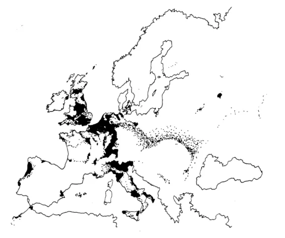
FIGURE 1. POPULATION DENSITY IN EUROPE. ( Areas shown solid black have over 200 persons/square kilometre.
)
Source: Der Regierungsbericht dber die Raumordnung in den Niederlanden, Mitteilungen aus dem Institut fdr Raumordnung, Bad Godesberg,1961.
From the map in figure 1 it may clearly be seen that the most densely pop-ulated parts of Europe form an almost continuous swathe-of development
running from the base of the Alps, broadening to encompass the Benelux countries, and continuing through South East England to the Midlands and South Wales. The English Channel thus not only separates Brit.gn from Continental Europe, it also constitutes the only major break in the densest part of this highly urbanised region.
The interactions of the Industrial *olution with existing transportation routes and the location of natural resources has resulted in the concentra-tion of most of Europe's heavy industry within this corridor, and has had a profound effect on the distribution of population. For a variety of rea-sons, the declining labour demand in many of the older, heavy industries has not been matched everywhere by a compensating metamorphosis in the
structure of the local economy, nor perhaps by sufficient population mobility, and there now exist several sizeable areas within this urban corridor which have severe economic problems deriving from the advanced obsolescence of their base activities. The Pasde-Calais, near the French end of the proposed tun-nel, is one such area, with wages 20 per cent lower, and mortality 20 per cent higher, than in the Paris region.
Finally, the geographical role of the Channel has changed. In addition to providing much of Britain's overseas trade with access to the Port of London,
the Tnglish Channel constituted a significant element in Britain's defences as recently as World War II. Traditionally, this had been the argument - per-haps not a very good one - against the Tunnel, but with the disappearance of the question of security, increasing emphasis on
3uropean
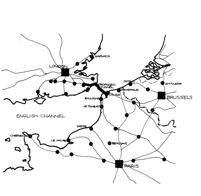
unity has tendedFIGURE 2.
CHANNEL TUNNEL ALIGNMENTS AND CONNECTING
.17
to focus attenition on the Channel's role as an impediment to the movement of people and goods between Britain and the rest of Europe.
THE PRESENT PROPOSALS: Background.
Why build a Fixed Link? Construction and Location.
19
Colorful and intergsting though the Tunnel's history is, a detailed pre-sentation would be inappropriate here. A chronology is provided in Appendix I, and those interested in a fuller treatment are referred to the bibliography, and particularly to the study by Slater and Barnett. The following section is therefore confined to an outline of the main events since the establishment of the Channel Tunnel Study Group, on 26 July 1957. The Group was set up on the initiative of the dispossessed Compagnie Finan-ciere de Suez, and comprised the following:
1. The Channel Tunnel Company Limited, (in which the British Transport Com-mission is a shareholder.)
2. The SocietK Concessionaire du Chemin de Fer Sous-Marin Entre la France et l'Angleterre, (in which the Sociftg Nationale des Chemins de Fer is the main shareholder, constituting, with its associate The International Road Federation (Paris), the French Group.)
3. The Compagnie Financilre de Suez.
4. Technical Studies Incorporated, of New York.
The members of the Group contributed equally towards joint studies which included the following:
A. A Traffic Survey (1) examining basic operational factors for the separate assumptions of a road or rail tunnel, analysing present traffic between
1igland and the Continent, its rate of growth, and of the traffic which would be diverted or created by the new route, and a study of charges 'and revenue.
(1) The Economist Intelligence Unit, London. Societe d'Etudes Techniques et 3conomiques, Paris. De Leuw, Cather and Company, Chicago.
20
B. Technical Studies comprising: a. Geological studies. (2)
b. Study of engineering methods, i.e. bored tunnel, immersed tube, bridge, and composite construction.
c. Design for a bored tunnel, consisting of a rail tunnel and/ or a road tunnel, separate but adjacent.
d. Scheme for an immersed tube. (3) e. Bridge study. (4)
f. 3stimated costsand:revenues for different types of construction.
C. Financial study of the implications of the traffic and engineering studies. D. Legal study of the problems involved in creating a public service common
to two countries, assuming financing and organisation by an international, privately-owned company.
The group's subsequent report, published on 28th March 1960, favoured, "in the first stage at least, a railway tunnel, bored or immersed" with facilities for the transportation of road vehicles by rail.
In December 1960, the Socicete d'Etude du Pont sur la Manche undertook fur-ther studies culminating, in October 1961, in a proposal for a 21 mile road and rail btidge linking Cap Blanc Nez to South Forelarid.
(2) J. M. Bruckshaw, Imperial College, London; J. Goguel, Ecole des Mines, Paris; W. 0. Smith, U. S. Geological Survey.
(3) Sir William Halcrow and Partners; Messrs. Livesey and Henderson; Messrs. Rendel, Palmer and Tritton, London; Socieft4 Genrale d'Exploitations Industrielles, Paris.
21
On 17th November 1-961, the British and French Ministers of Transport
de-cided to set up a working group to look into and report-on these two sets of proposals. Having considered the traffic, technical, legal, economic, and financing problems, the group concluded (1) that of the proposals they had studied, a tunnel would be preferable both to a bridge and "to the con-tinuous use and development of established means of transport."
In 1966 the British and French governments agreed that the Channel Tunnel should be built provided that satisfactory financial arrangements could be agreed. Discussions on the choice of a group to arrange financing and construction continue. When a group has been decided upon, it will carry out a financial and technical feasbility study before approval is given for them to finance construction. The operation of the tunnel will be by a public authority comprising French and British officials.
Why Build a Fixed Link?
As remarked in the Introduction, one of the more curious aspects of the present chapter in the Tunnel's long history is the concentration of debate on how to build a link, rather than why. As The Times has observed; "... the extraordinary thing is that no official case has ever been made for it: not the kind of case, that is, that ought to have been made for a project 6f such
(1) Proposals for a Fixed Channel Link, Cmnd. 2137. IMSO, September 1963, London.
22
magnitude, with important reprecussions on regional and economic planning, and on our physical and political links with Europe." (1)
The Franco-British group who prepared the report presented to Parliament by
the Minister of Transport in September 1963 did not bfPerki ., consider
that the repercussions would be significant, but also stated, in the same breath, that -they thought them impossible to assess. The group's economic assessment of each system was "limited to the costs and benefits of its operators and users". (2) .ven this, however, they acknowledged to contain a number of uncertainties, such as current developments in transportation technology, and unquantifiable elements such as amenity, which it was agreed would result in a difference in traffic generating power of a tunnel
com-pared to that of a bridge.
Beyond this, the services which a fixed link would offer were summarised as increased cross-Channel traffic capacity, and a reduction in surface travel time, which would, for example, make the journey between London and Paris
almost as cuick by
tail
as by air.There have been isolated cries of dissent in the correspondence columns of the usual newspapers, accusing the Government of, among other things, "a conspiracy of silence", and of plotting the destruction of a large part of
(1) Article by Michael 3aily; The Times, April 3, 1968. (2) P. 32, Proposals for a Fixed Channel Link. op.cit.
23
"what has always been known as the Garden of Angland". (1) Generally, however, the mass of the British public seems to have assumed - and its Government has indeed left it guessing - that the decision to build a Channel Tunnel is only natural in view of Britain's new-found interest in
her affairs with Europe.
Construction and Location.
As present proposals,stand, the Channel Tunnel. would consist of two parallel single-track railway tunnels, each 21'4" in diameter, with a saml1er service tunnel, 12'6" diameter, between and slightly below them. The Tunnel, which would probably be bored. through the Lower Chalk, would rise to a peak in mid-channel, draining to coastal pumping stations. It would be located at
approximately the narrowest part of the Straits of Dover, and its total length would he 32 miles, of which 23 miles would be under the sea. The two terminals,
44 miles apart, would be at Sangatte, four miles southwest of Calais, ahd at a still underdetermined location between Ashford and Folkstone on the British
side. (2) It is estimated that the tunnel could be in operation by 1976.
(1) Lt. Col. P. L. Murray Lawes: Leter to The Times, April 8, 1963.
(2) In a paper dated November 19, 1963, the Ministry of Transport considers Cheriton and Sellindge to be the options. (The Channel Tunnel: A Dis-cussion of Terminal Reouirements on the British Side and of Possible Locations for Terminal Facilities in Kent. Kent County Council,
24
Types and Caacity of Service Pr2oosed.
The Tunnel would have 25KV overhead electrification, and would be used by the following types of service
(a) Through rail freight services ( including freightliner trains) between centres in Britain and on the Continent;
(b) Fast inter-city passenger and car-carrying trains between centres in Britain (not only London) and on the Continent (not only Paris) (c) A fast and frequent shuttle service of specially designed
',ferry-trains" running between terminals near the Tunnel portals and
carrying up to 300 road vehicles ( cars, caravans, lorriescoachesi) per train. This ferry service would have a peak hour capacity of
12 trains, or
3,600
vehicles, per hour in each direction , 6ver an eighteen-hour day. Transit time would be about35
minutes, plus 30 minutes for waiting, loading, unloading, and customs inspection.(d) Possibly additional passenger trains of standard continental rolling stock and freight trains handled by continental locomotives. Because of loading gauge restrictions, such trains could run in the U.K. only as far as terminals near the Tunnel portal.
25
TRANSPORTATION.
This section describes the main lines of the national transportation network, including Britain's links with continental Europe, as it is now and, where sufficient information is available, as it seems likely to develop. The description is organized by mode, and each section includes a more detailed treatment of the present and predicted posi-tion in South East England, where the impact of a tunnel will, be more directly felt. Throughout the section, extensive use has been made of maps. In the vicinity of the London-Paris-Brussels triangle however, the patterns of activity are so extremely complex and overlapping that, in the interests of clarity, the information has been repeated, this time by mode.
The National Network.
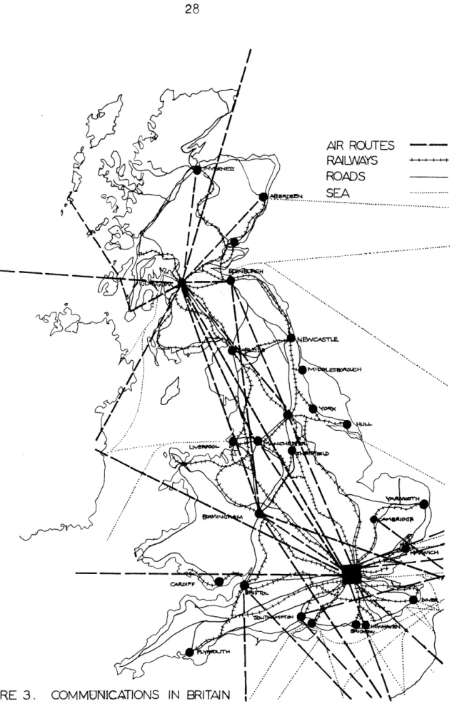
From the map in figure 3, showing the main arteries in Britain's trans-portation system, two facts are immediately apparent. First, national : and internal communicktions are focussed on and dominated by London. Second, the system is predominantly north-south oriented, the two main land routes flanking the central spine of mountains and running suffi-ciently far inland to avoid being obstructed by the several estuaries which cut deeply into the main land mass, a pattern which differs little from that established by the Romans.
Cross-Channel Traffic.
The passenger and vehicular sectors of cross-Channel trafficare highly seasonal. Twenty-five per cent of the annual total is handled in August
28
29
alone, and 70 per cent within the four month period from June to September. Within this seasonal concentration, there is particularly heavy traffic at week-ends. Although the sea routes still carry the bulk of cross-Channel passenger traffic, the proportion going by air is increasing, particularly between Britain and the Low Countries.
MAJOR ROADS IN BRITAIN (1968)
,-- 1CL rITSH gCAQ FoATOM
Roads in Great Britain.
The form of Britain's public road system is derived from the interaction of the Roman system, conceived from a military standpoint, and the later
Anglo-Saxon network, designed to meet the needs of an agricultural society.
The accompanying map, figure h, shows the main lines of the motorway (similar to U.S. freeways) system presently under construction, as it now exists and as it is proposed. As with communications generally, the overall pattern is one of north-south orientation with radiAl development around London. The system, as can be seen from the map, is by no means without interruption at present. Further, because of delays and lack of money, the Government's target
of 1000 miles of motorway by 1973 is certain not to be met, and even if it were, it would be quite insufficient to provide an adequate system between the South-East and the lagging regions of Wales and the North.
Roads in the Southeast
Although the South East Economic Planning Council reported (1) that the location of existing route network in the region was well suited to anticipateddevelopment, it stressed that its capacity was not. It pointed to a 'very fast' increase in the amount of traffic, and in view of the expected importance of the passenger sector in total tunnel traffic, it is worth noting that while the number of all
(1) Strategy for the South East. A first report by the South East Economic Planning Council. HMSO 1967.
32
NorTHAMPiTcN MILTON KEYNiES TO OXFrORD OUT iANTS SXJDMMPTTORcads to be comoeted to high standard by 1975
already in existence:
Other important roads:
Road proposals after 1975:
priorities
:
vehicles in the South East doubled between 1951 and 1964, private cars in-creased almost threefold, and their number is expected to have doubled again, to approximately six million, by the late 1970's.
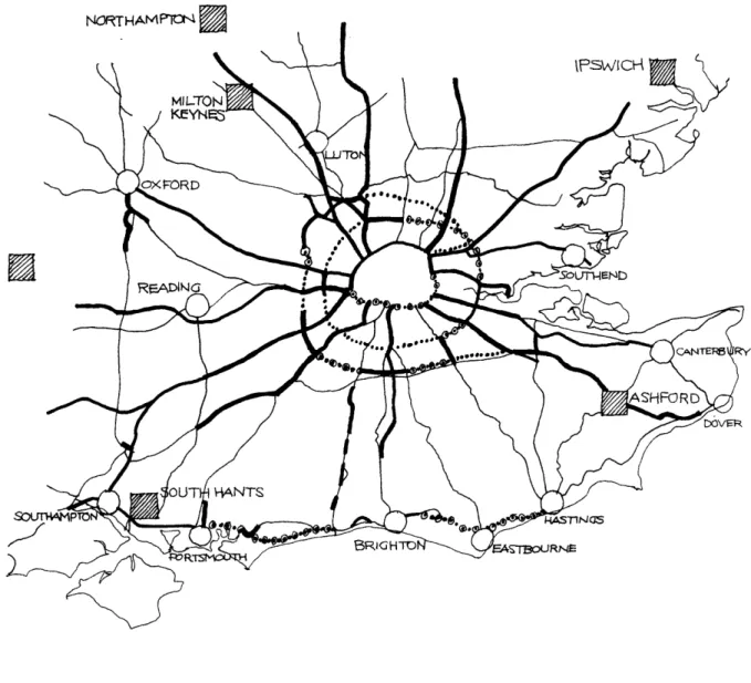
The council frankly recognised that the investment resources available were
incapable of meeting the predicted demands for new constructior ) but established certain 'strategic priorities'. The map in figure
5
summarises thesere-commendations. Finally, the long standing economic plight of the United King-dome has caused highway construction programmes to fall behind schedule, and it is by no means clear that even these 'strategic prioritiest will be met. Special importance is given to ring road construction, with the intention of keeping as much traffic as possible - 'e.g. from the Channel Tunnel' - out of the London area, and the urgency is also stressed of substantially improving the south coast route linking eastwards with the developments in Kent and the Channel Tunnel, and westwards to South Hampshire.
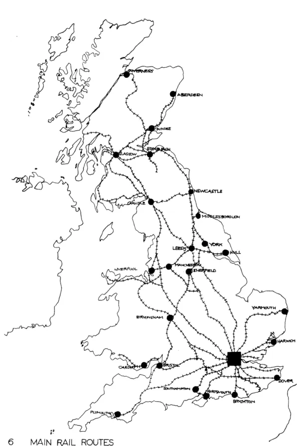
Railways in BritAin.
Rail communications (see figure 6) in Britain, like roads, focus on London, with relatively poor east-west communication between the main lines to the north.
Railways in the South East
C
AsErjces
Main lines
Other routes
FIGURE 7.
RAILWAYS IN THE SOUTH EAST, (Source: A Strategy for
36
The lines radiating to the south and to Essex are heavily used, (1) but there is considerable unused capacity on trunk lines to the north and north west. Although improvements and further electrification of existing lines are pro-posed, no new routes - other than the Tunnel - or major increases in capacity are considered necessary. Official studies on the probable effect of both the Channel Tunnel and the third London airport have not, however, been com-pleted, although naturally both factors are expected to make an impact.
Shipping.
Although there is some sea traffic between continental Europe and the more northerly east coast ports, such as Hull and Leith, the great bulk of sea trade with Europe is handled by the ports between Southampton and Harwich. The ports in the south east handle more than 35 per cent of Britain's total
freight traffic, mostly on the Thames and Medway, but also through Southamp-ton. Although the remaining ports account for only fiveper cent of the
region's freight traffic, the short sea routes are heavily used, and expanding fast.
By far most of the region's passenger traffic is cross-Channel, but the deep sea passenger traffic in and out of Southampton accounts for
65
percent of the national total.(1) Of the 1.2 million people entering central London each morning rush
hour, 40 per cent travel by British Rail, and a further
50
per centRDAM
E
LONDON
SOUT H~re
passenger and cargo
car
ferries
other shipping
travel
time
in
hours
i+MAP OF CHANNEL SHIPPING
FIGURE 8
LANES
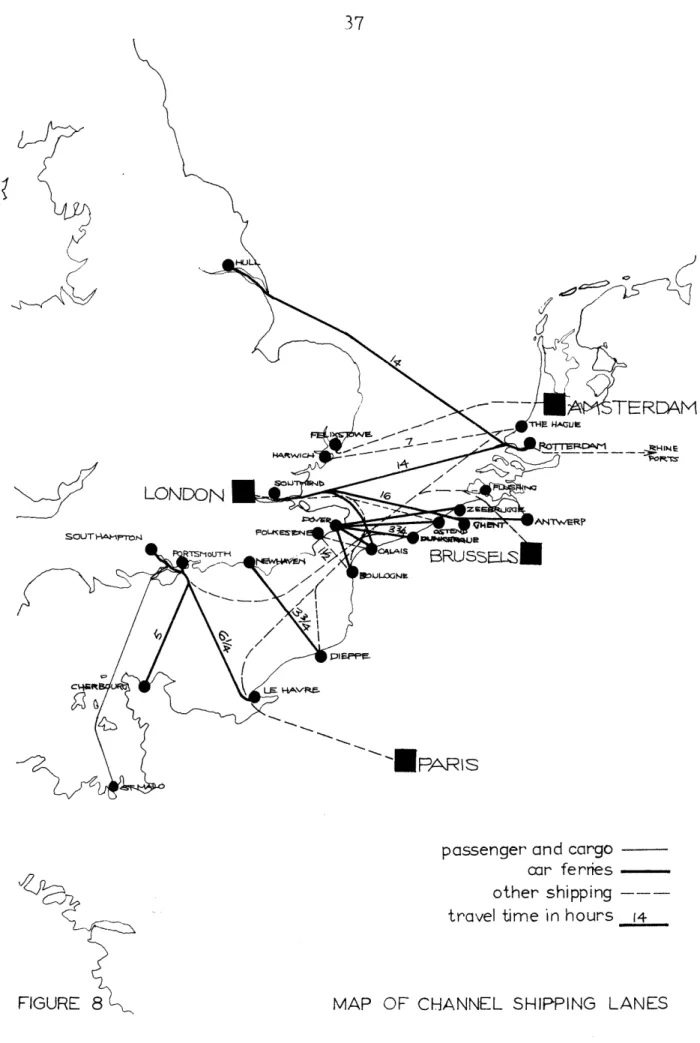
In the future there is likely to be continued expansion of the London docks in a down river direction, and further expansion of facilities for handling container traffic.
Main Channel shipping lanes are shown, with typical travel times, on the map in figure 8.
Finally, developments in 'ro-ro' (roll on, roll off) ships and containeri-zation have caused sea freight rates to fall by as much as 40 per cent, and high capital investments have been made in the container field, with British
Rail undercutting their rivals to gain the high utilization required.
Air Transport
Although there are several direct flights from the provinces, most air ser-vices between centres in Britain and those in Europe go through London, utilising the capital's 611 routes to the continent, a factor which has con-tributed to the intensity of traffic on certain internal lines. The Glasgow-London service, for example, with 700,000 passengers in 1968, is the busiest in Europe.
In 1966, London's two international airports handled 13.5 million passengers, which is 13 per cent more than the previous year. Freight traffic is increasing by about 20 per cent annually. A third major airport, to handle all types of traffic, long medium, and short haul, is proposed, although its location remains undecided.
Several smaller airports in the South East ferry cars, passengers, and limited amounts of freight across channel. Until the recent advent of hovercraft ser-vices, these provided the only alternative to the traditional ferries for
BIRMtA.GHAM
BRUSSELS
'
~LILLE
BEAUVAWS
I
BAR
S
car ferry service - c
-MAP OF CROSS-CHANNEL AIR SERVICES
40
motorists, and are well patronised, although delays during peak season often
cancel out any time advantage over other modes.
Hovercraft
The first regular cross-Channel hovercraft service was inaugurated in the
summer of
1968
by British Rail's Seaspeed organization, operating a
$4,200,000
SRN "Mountbatten" craft between Dover and Boulogne.
As a
com-mercial proving exercise, the operation was generally successful, and a
second craft of the
same type will be added in 1969.
Each craft can carry
254 passengers and
30
cars, and takes 40 minutes to complete the crossing.
A new service will also be opened this year between Calais and the newly
constructed terminal at Ramsgate.
Operated by Hover1loyd, Ltd. this service,
the most ambitious commercial application of hovercraft yet, will make up to
20 crossings daily, with a journey time of 40 minutes.
no
The outlook for passenger hdVercraft on Channel routes is by/means certain, but
it would appear to be promising. The outlook for freight traffic is less so.
The amount of time saved is of less value than it is to passengers, and the
cost is higher. For high value cargo, air freighters may prove faster and
cheaper. (1)
The
map in figure
10 shows the existing routes.
41
LONDONLI
i
PAR\S
SEASPEED(BRITISH
RAIL)
HOVERLLOYD
Coach links
HOVERCRAFT
ROUTES OPERATIONAL IN 1969,
-E
TRANSPORTATION :
This section deals with the effects of the tunnel's completion upon existing patterns of passenger, vehicular and freight traffic. The facilities typically provided by existing mode of cross channel trans-portation are compared in terms of time, cost and convenience with the sort of service envisaged by the current tunnel proposals outlined in the previous section.
The investigations carried out on behalf of the Channel Tunnel Study Group represent the most up-to-date comprehensive source available, but the consultants' report (1) was published in 1960, on the basis of data collected in 1958, so that the last full year for which information was obtained was 1957. There have been developments since then which ought to be taken into consideration. Apart from technblogical advances, such as hovercraft development and the growth of containerization, the esti-mated cost of the tunnel has gone up considerably. Prom the $338.4 mil-lion of the 1963 proposal (2), the estimate has risen to $720 milmil-lion, and another $24 million is added with every year that passes.
1. Channel Tunnel Traffic and Revenue Summary . op. cit.
2. After subtracting.-a credit of $57.6 million which the sponsors
allowed themselves for the sale of ships and aircraft put out of business by the Tunnel.
Rail/Sea Passenger Traffic.
At present, the "Golden Arrow" train-ferry-train service via Dover and Calais takes eight hours. The "Night-Ferry" which operates via Dunkerque, and has through sleeping cars, takes eleven hours. Overall trip time between London and Paris rail terminals via the Channel Tunnel would be about four and a half hours, offering a saving of about three and a half hours over a fast, rail service. The introduction of direct services between provincial British cities and Europe would offer even greater
savings.
It is proposed that the Tunnel charges would be similar to those on the present Dover-Calais ferries, so no change in overall rail fares is anti-cipated.
Obviously, a tunnel route would avoid the present inconvenience of inter-mediate changes from train to boat and back again. There has been some discussion of the problem of the stress involved in such a long tunnel trip, but from the precedents of the London tube and the Paris Metro, it seems unlikely that this will pose serious problems to many people, and will probably be seen as fair exchange by those prone to seasickness.
Of the eleven main cross-channel sea routes ( excluding hovercraft
routes ) presently operating, the Channel Tunnel Study Group's consultants
were instructed to assume that six now operated by the British and French Railways would be discontinued on the opening of the tunnel. This would
45
represent approximately half of all passengers by sea in 1957. ( see table below).
Sea Passengers by Route in 1957 ( excluding those in vehicles )
Route Carried by Sea
in 1957 Percent of Total To be discontinued Dover-Boulogne Dover-Dunkerque Dover-Calais Newhaven-Dieppe Folkestone-Boulogne Folkestone-Calais Total to be discontinued To remain Dover-Ostend Harwich-Hook Southampton-Le Havre Harwich-Esbjerg Southampton-St.Malo Other Routes Total to remain
Total carried by sea
35,000 88,000 387,000 322,000 320,000 377,000 1,529,000 868,000 478,000 57,000 56,000 35,000 168,000 1,662,000 3,191,000
Source: Channel Tunnel Traffic and Revenue Summary, Section 1. op.cit.
1.1 2.8 12.1 10.1 10.0 11.8 47.9 27.2 14.9 1.8 1.8 1.1
5.3
52.1 100.0Air Passenger Trafic
Between city centres, the London-Paris journey by air takes approximately four hours
(
less than one of which is actually flying time ). The pro-jected rail route via the tunnel would thus still be slower, but only marginally so, at four and a half hours. It would be cheaper, at $11.20second class, compared to $22 tourist by air.
The coach-air-coach service between London and Paris via Lympne and 3eauvais, with a journey time of six hours and a single fare of $11.80 would appear unable to compete with the four and a half hours and $11.20
offered by the tunnel route, on which intermediate changes would be unnecessary.
Passenger Survey
During peak and off seasons in 1958, origin-destination surveys were carried out on all main cross-Channel passenger routes to determine travel patterns and the reasons for choice of route and travel mode. Analysis of the data indicated a direct relationship between the cost of using a route and the number of passengers who used it. Allocation curves were derived-to assign passengers to the Channel Tunnel. The number of passengers estimated to be divertible increased with the relative saving offered by the Tunnel. Approximately 68 per cent of the passenger traffic estimated to be diverted to the Channel Tunnel
will come from the discontinuation of the six sea routes mentioned. The remainder were reckoned to come from continuing sea routes and
some of the existing short haul air routes.
Existing and Estimated Diverted Passenger Traffic (1)
Passengers
Sea- Discontinued routes Retained routes Sub-Total
1957
Actual 1,529,000 1,662,000 3,191,0001965
Estimated Without Tunnel 2,170,000 2,358,000 4,528,0001965
Estimated Diverted to Tunnel 2,170.000 428,000 2,598,000Air- Regular Route London-Paris London-Belgium London-Netherlands Other Routes Sub-Total
TOTAL
1,032,000 1,527,000 2,559,0005,750,000
2,837,000
4,043,000
6,880,000
11,408,000
1. Source: Channel Tunnel Traffic and Revenue Summary, Section 1, opcit. 532,000
50,000
582,000 3,180,000
48~
Projected train times between city centres on routes between London and Paris, London and the Netherlands, London and Belgium, compare quite favourably with air travel times, and it was estimated that 70 per cent of these constituted potential passengers, 25 per cent of which would be directed to the Tunnel.
Future Growth of assenger traffic
The consultants estimated that passenger traffic would increase approxi mately in proportion to the increase of national income in the countries
served by the Tunnel, resulting in a projected increase in the number of passengers carried, from 3,180,000 in 1965 to 5,092,000 in 1935.
Vehicular Traffic :. General
In 1957,81.6 per cent of 285,000 accompanied vehicles crossed the Channel by sea, and 18.4 per cent by air. The average vehicle occupancy was just over three persons. Services were fully booked during the peak months
-particularly August - with a great deal of unused capacity during the rest of the year,
Of the 233,254 accompanied vehicles which crossed the Channel on six main routes, 165,789 were carried on four routes which would be discontinued on the opening of the Tunnel,
Substantial numbers of vehicles are ferried across the Channel by air. In 1951, 52,600 ( of which 44,600 were passengerevehicles
compared with 2,700 in 1949.
The tunnel charge of $20 for a private car with three passengers would be half that of the cheapest air ferry. Origin-destination surveys of accompanied vehicles showed a direct relationship between the cost of a particular route and the number of motorists using it. Time, distan-ce and fares were assigned monetary values, and allocation curves de-rived to assign motorists to the Channel Tunnel. Two-thirds of those divertible were estimated to come from discontinued sea routes, the remainder from air and other sea routes.
Induced Increase in Vehicular Traffic
In the years immediately following the replacement of a ship or ferry service by a form of fixed link, additional traffic is generated, partly because of improved service, bur also because of lower travel costs and changes in travel ( vacation and business ) habits. Relating the percentage of generated traffic to the fare charged, the consultants estimate that generated traffic would be approximately 60 per cent of diverted traffic.
Finally, relating growth in accompanied vehicular traffic to increased vehicle registration, and that in turn to rise in per capita GNP, the
Number of Year Vehicles
1965
676,000
1970 833,000 1975 990,000 1980 1,127,0001985
1,196,000
(
Source Channel Tunnel Traffic and Revenue Surmary , op.cit.)
Since the preparation of the consultants' report, the general sensitive economic situation in Europe, and particularly in Britain, has put a brake on the growth of tourism, and also on the increase in numbers of motor vehicles registered. In this connection, it should be noted that 75 per cent of cross-Channel vehicular traffic is registered in Britain.
vreight
Of Britain's 5,700,000 tons of imports and 4,800,000 tons of exports
in 1957, two-thirds were in bulk form and were carried at rates so low that the Tunnel charge of $5 per ton could not compete. Of the bulk imports, 70 per cent were fertilizers, grain, ores and scrap, and 20 per cent coal and coke. Bulk exports were mainly coal and coke. Of the remaining 3,500,000 tons not in bulk form, it was estimated that one third would be diverted to the tunnel. Nearly 500,000 tons of freight a year, or 15 per cent of the Tunnel's potential total is at present carried by the two rail ferries and the Tilbury-Antwerp vehicular ferry as follows :
531
Dover-Dunkerque 240.000 tons (1957) Harwich-Zeebrugge 225.000 tons
Tilbury-Antwerp
7.000 tons (20.000
in 1958
)
Hovercraft
Since the Channel Tunnel Study Group's consultants prepared their estimates, hovercraft services have begun to operate on a commercial basis between Dover and Boulogne, and from Ramsgate to Calais or Ostend. Crossing times are similar to the projected rail time via the Tunnel, and the cost is highly competitive. Dover-Boulogne by British Rail's Seaspeed service costs $7.20 single for passengers, compared to the Tunnel's projected fare of $6.85. Even more interesting is this year's $9.60 single fare for the bus-hovercraft-bus service from Lodon to Paris or $9.30 to Ostend.
These prices would appear to be thoroughly competitive on ferry shuttle traffic, although about 90 minutes slower on, for instance, the Iondon-Paris trip. The Ministry of Transport has asked that additional work be done on the competitiveness of these services, and also on the matter of containerization, to ascertain their effect on the economic viability of the Tunnel.
For freight transportation, as remarked earlier, there is no indication yet that hovercraft will be sufficiently competitive to upset existing trends.
52
FIGURE
12
53
This section deals with regional development policy in Great Britain-so far as one may be said to exist on a national scale. Its main concerns will be identified, the present situation and trends in these areas
described, and current policy summarised. A later section will look at how these factors are likely to be affected by the sorts of changes in the transportation network which would result from the construction of a Channel Tunnel.
In view of the relatively widespread and long-standing acceptance of planning, not to say Government intervention,in Britain, it is surprising to reflect that the first comprehensive regional plan ( for Central
Scotland
)
did not appear till 1964. Others have followed hard on its heels, but so far no mechanism seems to have emerged to ensure the matching of these individually constructed pieces to form a coherent whole.Although no truly comprehensive national plan exits, there is, however, national policy on certain issues such as regional economic development. Since its beginnings in the late 1920s, Government policy in this field has been primarily an employment policy - or, rather, an unemployment policy - aimed at reducing the level of unemployment in those places where it has been markedly higher than the national average.
While the aim has remained the same, the strategies adopted over the years have varied. Initially, the emphasis was on the movement of labour,
first in mininglater in other industries, from areas of high unemployment to more prosperous regions, and it is ironic to reflect that grants were actually available to enable people to migrate south and east. Although this policy was coupled with a retraining scheme, without an accompanying increase in the aggregate demand for labour, the net effect was to re-distribute unemployment, rather than to reduce it in any real sense. As one Lanarkshire M.P. put it , some thirty years later, there were unemployed men teaching other unemployed men a new skill, which would leave them unemployed. (1) The relevance of this to present policy is,
quite simply, that public dislike of policies involving transference of labour, and scepticism about training schemes, was greatly
strength-ened by the failure of these early efforts.
Having rendered the policy of moving people to jobs politically un-acceptable by failing to couple it with real economic growth, successive Governments since the late 1930s have concentrated instead on trying to move jobs to people. It may be argued that this is not really very different, that in economic terms the second approach may be more disastrous than the first, and that to treat unemployment as the
problem rather than a symptom of one is altogether the wrong approach. In any case the uneven distribution of unemployment has not only
persisted, but has changed little in form, although levels of un-employment are genrally lower than before World War II. The areas most affected are Scotland, Wales, the North of England, certain parts
of Lancashire, and parts of Cornwall and Devon. Some of these regions are of course agricultural, but of the others, many were among the first in Britain to industrialise, and became increasingly specialised in and dependent upon activities such as coal and steel production, shipbuilding, textile manufacture, and heavy engineering. The demand for labour in these industries has, however, been declining since the
1920s, and the newer consumer-oriented industries which began to be established, particularly after World War I, tended to locate near to the rich markets of the Midlands and the South.
Various frictions within the situation have inhibited the development of market solutions. Wages have been downardly inelastic, and no wage differential emerged, even under conditions of widely varying levels of unemployment, sufficient to cause business to move of its own free will. Finally, any tendency there might have been for people to follow jobs, or such wage differentials as did develop, has been greatly hampered by the severe housing shortage, particularly in the more prosperous areas, where the price of land has risen sharply.
With no market solution forthcoming, and with policies involving the fostering of migration discredited, governmental intervention, since the Special Areas Act of 1934, has focussed on the creation of jobs in areas of high unemployment by inducements to industry to go there, and the discouragement or prevention of development in areas where unemployment levels are low.
56
The principal means of implementation have been in the form of loans
and grants available to firms prepared to set up in Development Areas,
and a system of Industrial Development Certificates which applies to
all industrial buildings over 5000 square feet in area. I.D.C.s are
automatically granted if a firm wants to build in a Development Area,
but are refused in more prosperous areas
(
generally south and east of
Stoke-on-Trent
)
unless the Board of Trade can be convinced that such
a development is incapable of being carried out reasonably successfully
in a Development Area.
This has not always had the desired effect. Some firms which have been
refused permission to develop in the location of their choice have
simply decided not to expand at all; others have made more intense
use of existing premises, and last - but not least - some have responded
to Government interference by going outside Britain altogether.
These policies have, to their considerable detriment, been subject to
a
"
stop-go
"
form of implementation as the country's financial crises
wax and wane; the prompt de-listing of development areas as soon as
unemployment drops below the critical level does not produce a
climate conducive to sound industrial planning. Finally there has
been a drastic lack of coordination among the various Government
departments involved. The Board of Trade. however, is quite explicit
about the independence of its decisions on employment policy from
national economic considerations, a point of view not shared by the
Treasury, If the Board of Trade were advised that a firm would be
viable in Durham or Fife, the Board would not consider whether the
national economy would be better served by the firm's being placed
in
the South of England.
(t)
In a statement to the
Select Committee,
a
Board of Trade official stated that
"
in one sense one could say
that it
(
expenditure on local employment policy) was all of a
social service nature". (2)
A detailed critique of regional policy is not relevant here (3);
what it is iaulptant to make clear is that,in spite of the lack of
coordination among the Board of Trade, the Treasury, the Ministry of
Transport and the other departments concerned, the first objective of
regional development policy in Britain emerges quite clearly as the
alleviation of regional differentials in unemployment levels,
irres-pective of whether the measures necessary to achieve this end are of
benefit to the nation's economy as a whole.
1. Seventh Report from the Estimates Committee, Session 1962-63,
Administration of the Local Enployment Act, minutes of evidence,
question 264.
2. Ditto, question 1323.
3.
A good short one exists, by Allan J. Odber, in
"
Area Redevelopment
Policies in Britain and the Couni5ies of the Common Market
",
prepared
by the Institute of Industrial Relations, UCLA, and published by
-I---58
The unemployment situation in the various regions in recent years is given in the table below, and the map in figure 12
extent of the designated Development areas.
Unemployment Rates, by Region 19 -62 Monthly Averages
Regions
1959
1960.
1961
shows the
Average-'
1962
1949-62
Liondon and South Eastern
1. 3 0. 9
1. 0
1.
3
1. 1
Southern
1. 5
1. 2
1. 1 1. 4
1. 2
SouthoWestern 2. 2 1. ? 1. 4 1. 8 1. 6
Midland
1. 5
1. 0
1. 4
1. 8
1.
0
North Midland 1. 5 1. 1 1. 0 1. 4 - 9
East and West Ridings of Yorkshire 1. 9 1. 2 1.
0
1. 6 1. 2North Western 2. 8 1. 9 1. 6 2. 6 2.
0
Northern 3. 3 2. 8 2. 5 3. 8 2. 5
Scotland 4. 4 3. 6 3. 1 3. 8 3. 1
Wales 3. 8 2. 7 2. 6 3. 8 3. 0
Great Britain
2. 2
1. 6
1. 6
2. 1
1. 6
The second major concern of regional policy in Britain, related to the first, is the matter of population distribution, and particularly of congestion in large urban areas. The effect of migration is to aggra-vate not only the problems of areas which the government sees as already congested, but also those of the declining areas. The selec-tive nature of voluntary migration has caused the age distribution in these areas to become steadily more lop-sided, with the labor force deteriorating into a pool of obsolete skills.
In 1937, the Royal Commission on the Distribution of the Industrial Population ( Barlow Commission ) was formed " To inquire into the causes which have influenced the present geographical distribution
of the industrial population of Great Britain and the probable direction of any change in that distribution in the future; to consider what social, economic or strategical disadvantages arise from the concentration of industries or of the industrial population in large towns or in parti-cular areas of the country; and to report what remedial measures if any should be taken in the national interest. "
This was the first time an official body was implicitly asked to examine facts and trends in the related problems of urban congestion and regio-nal stagnation. The Commission stated: " The disadvantages in many, if not in most of the great industrial concentrations do constitute se-rious handicaps and even in some respects dangers to the nation's life and development and we are of the opinion that definite action should be taken by the Government toward remedying them,". It is unfortunate that they were not asked to, and did not, consider the advantages as well as the disadvantages of concentration.
The commissioners were not unanimous in their recommendations. The majority report advocated a ban on the establishment of new inrdustry in London and the Home Counties, and the " creation of more fa :oura-ble conditions of life and work in other parts of the country " to counteract the attraction of London.
A minority of three proposed the formation of a new Ministry, to be responsible for a continuous review and a general control over the
60
ever changing industrial and social environment. Neither report was accepted, and responsibility for the various components of what might have been- a national planning policy was dispersed among several Govern-ment departGovern-ments. None the less, congestion has remained a major
concern, and considerable progress has been made in the overspilling of population from centres such as London and Glasgow to New Towns and other areas.
61
National Population Growth and Density.
In mid-1968, the estimated population of
the 94,214 square miles which
make up the United Kingdom of Great Britain and Northern Ireland was
55,459,000. Current projections by the Government Actuary's Department
in conjunction with the Registrars General suggest an increase of rather
more than two million people by 1975, taking into consideration factors
such as the Commonwealth Immigration Act of 1962, a net loss by
migra-tion, and a downward trend in the nation's birth rate. The total
popu-lation for the year 2000 is presently estimated at 70,339,000, or an
increase of just over 20 per cent on the figure for 1969.(1).
The present overall factor of 588 persons/square mile places Britain
among the more crowded countries in the world, although in a purely
European context
the Netherlands, Belgium, and West Germany all have
higher densities. Of these, however, only the Netherlands with 969
persons/square mile surpasses the figure for England alone, of 897
persons/square mile. (2)
(1)
Annual Abstract
of Statistics.
HMSO, 1968.
(2) Rad McNally World Atlas. Rand McNally and
Co.,
1968.
62
Regional Distribution.
It can be seen from the preceding passage that the distribution of
population among the regions is uneven. With just over half the land area,
England has over 80 per cent of the total United Kingdom population.
Furthermore, distribution within England itself is uneven, the great
majority of people being concentrated in the urban areas of the Eidlands
and the South. The South East region alone contains over
35
per cent of
the United Kingdom total, with Greater London, dominating the admi-.
nistrative, cultural, and commercial life of the country, accounting
for some eight million.
To a considerable extent, the general picture of national population
distribution reflects patterns of activity which evolved during the
Industrial Revolution. Although the industries of that period have in
many cases been replaced in significance by other, newer industries,
often in different
locations, the former pattern of population
distribution has tended to linger on. Despite a distinct sluggishness
in the redistribution of population to fit 20th century patterns of
industrial location, the general trend since World War II has none
the less been one of movement particulary of young skilled people
from areas of high unemployment to those where it has been lower. The
steady outflow from Scotland, Wales, and the North of England, with a
consequent depopulation of the northern and upland areas of Britain,
63
160-140
-FROM OUTSiDE EPGLCAND7 ANED WA L-5
NET MIGRATION BAL.
o -TO ANb REST OF ENC,
W/ALES, 80 4o -4o 20 0 2.19G2/3 19631 19GYG2.
(
S.E. REGION)
NET CIVILAN MIGRATION
64
has brought some net movement, particulary into the London area.
As figure 13 shows, the "drift to the South East" is no longer the
signi-ficant element in interregional movement that it was previously, nor
has its rate of natural increase been as high as those of Scotland,
the North of England, or the Midlands. Nevertheless, the percentage of
the national population already living in the South East is so high that
even a modest rate of growth involves absolute numbers which are very
large indeed.(1)
Home population
Million
1951
1961
1964 1965 1966
South East Region.
15.2
16.4 16.8
17.0 17.1
England and Wales.
43.8 46.2 47.4 47.8 48.1
United Kingdom.
50.3 52.8 54.1 54.4
54.7
The additional demands generated by the continuing overspill of population
from London further complicate the problems of coping with growth and
conserving amenity in the country's most densely populated region.
65
66
PERCENTAGE
CHANGE IN POPULATION
1951-61
F1GURE 15
20 1- C4R% DEC REASE O - 19 PEcrASE o -19 INCfsASE 20 +-ovR. INCR'EASE67
Redistribution of Locational Advantage
The preceding section described how traffic distribution might be affected by the Tunnel. These changes would alter the balance of locational advantage within the South East region, in Britain as a whole, and to some extend in a wider context also.
Although the appearance of the hovercraft and the container ships as competitors complicates matters, the immediate effect of the Tunnel
to
in Britain would certainly be/concentrate much of the cross-Channel traffic, presently dispersed among the seaports and airfields of the south and east coasts, upon Ashford, with a corresponding decline initially, at least, in the economies of the coast ports. More impor-tant in a national sense, though, is the fact that whatever the environ-mental consequences of catering, in this densely populated region, for the increased and concentrated traffic which will result, improved access to Europe ( by whatever means) can only make the South East
0
a mre attractive location for industry than it is now. Any additional development resulting from this increased attractiveness to industry would impose ,of course, its own traffic demands upon the confessedly inadequate road system of the region. (1)
A corollary of the South East's increased attractiveness to industry is a decrease in the relative attractiveness of other regions of Britain
(1) Strategy for the South East op. cit.
particularly those without direct acce3 to the Tunnel, or too incon-veniently located, because of distance or poor communications, for it to make any favourable difference.
On the other side of the Channel the repercussions of improved trans. portation would be felt in a very different context. In the relatively impoverished North East of France, unlike the prosperous and densely developed South East of England, land and labour are comparatively cheap, and the area is actually conveniently located to more major European centres than is its British counterpart. The diversion of traffic at present flowing directly between Britain, Belgium, the Netherlands and other European counries to the Tunnel, and therefore through France, would place the Calais region in a highly strategic position at the crossroads of the revised regional communication pattern.
It should be noted that this locational advantage is not without cost to France's neighbours. For example, Ostend with its inter-dependent base activities of tourism and transportation would lose heavily, to the considerable gain of Calais. Reference has already been made to the improved position in which the Calais region will find itself, relative tb the South East of England. Finally the abandonment of modes of transportation which have great route flexibility in favour of a fixed link would greatly increase the vulnerabi.lity of British trade with Europe to such risks as French