HAL Id: hal-03224352
https://hal.archives-ouvertes.fr/hal-03224352
Submitted on 11 May 2021
HAL is a multi-disciplinary open access
archive for the deposit and dissemination of
sci-entific research documents, whether they are
pub-lished or not. The documents may come from
teaching and research institutions in France or
abroad, or from public or private research centers.
L’archive ouverte pluridisciplinaire HAL, est
destinée au dépôt et à la diffusion de documents
scientifiques de niveau recherche, publiés ou non,
émanant des établissements d’enseignement et de
recherche français ou étrangers, des laboratoires
publics ou privés.
Winter drought variations based on tree-ring data in
Gaoligong Mountain, Northwestern Yunnan, China, A.
D. 1795-2004
Zongshan Li, Chunming Shi, Yongbo Liu, Jinlong Zhang, Qibing Zhang,
Keping Ma
To cite this version:
Zongshan Li, Chunming Shi, Yongbo Liu, Jinlong Zhang, Qibing Zhang, et al.. Winter drought
variations based on tree-ring data in Gaoligong Mountain, Northwestern Yunnan, China, A. D.
1795-2004. Pakistan Journal of Botany, 2011, 43, pp.2469-2478. �hal-03224352�
Winter drought variations based on tree-ring data in Gaoligong Mountain,
Northwestern Yunnan, China, A. D. 1795-2004
Article in Pakistan Journal of Botany · October 2011
CITATIONS 9
READS 266 6 authors, including:
Some of the authors of this publication are also working on these related projects:
Forest RestorationView project
bryophyte biologyView project Zongshan li
Chinese Academy of Sciences
90PUBLICATIONS 892CITATIONS
SEE PROFILE
Chunming Shi
Beijing Normal University
31PUBLICATIONS 785CITATIONS
SEE PROFILE
Yongbo Liu
Chinese Research Academy of Environmental Sciences
43PUBLICATIONS 501CITATIONS
SEE PROFILE
Jinlong Zhang
Kadoorie Farm and Botanic Garden
73PUBLICATIONS 885CITATIONS
SEE PROFILE
All content following this page was uploaded by Keping Ma on 09 January 2016. The user has requested enhancement of the downloaded file.
Pak. J. Bot., 43(5): 2469-2478, 2011.
WINTER DROUGHT VARIATIONS BASED ON TREE-RING DATA IN GAOLIGONG
MOUNTAIN, NORTHWESTERN YUNNAN, CHINA, A. D. 1795–2004
ZONGSHAN LI1, 2*, CHUNMING SHI1, 3, YONGBO LIU1 , JINLONG ZHANG1, QIBING ZHANG1 AND KEPING MA1
1
State Key Laboratory of Vegetation and Environmental Change, Institute of Botany, Chinese Academy of Sciences, Beijing 100093, China
2
State Key Laboratory of Urban and Regional Ecology, Research Center for Eco-Environmental Science, Chinese Academy of Sciences, Beijing 100085, China.
3
Laboratoire des Sciences du Climat et de l'Environnement, UMR 1572, IPSL/CEA/CNRS/UVSQ,7 Bat 701, L'Orme des Merisiers, CEA Saclay, 91 191 Gif sur Yvette cedex.
Abstract
We developed two tree ring-width chronologies of coniferous species (Tsuga dumosa (D.Don) Eichler and Abies georgei Orr) in Gaoligong Mountain, northwestern Yunnan, China. Although the two chronologies come from different species, significant correlation existed between the two chronologies (r = 0.528, p<0.01), and the first principal component (PC1) accounted for 75% of total variance over their common period A. D. 1795–2005. Using the PC1 of tree-ring chronologies, the winter (prior October to current January) PDSI for the research area was reconstructed for the past 210 years (r = 0.617, p<0.01). Wet winters occurred during A. D.1827–1861, 1880–1896 and 1922–1961, while dry winters were prevailed in A. D. 1795–1826, 1862–1879, 1897–1921 and 1962 to present. Long-term decadal drought variations of this reconstruction fitted quite close with the variations retained in drought sensitive tree-ring series of the nearby regions, and this demonstrated the new record was confidently reliable and could capture large-scale climate signals.
Introduction
Northwestern Yunnan is located in the central Hengduan Mountains (Yunnan Province of southwestern China), which is famous for the Three Parallel Rivers of Yunnan Protected Areas established in 2003 as a UNESCO World Heritage Site (Feng et al., 2009). The region is well known for its high levels of biodiversity owing to the steep topographic gradients resulting from Mekong, Yangtze, Salween and Irrawaddy rivers which cut deep, north-south oriented gorges in the mountainous landscape (Li & Li, 1993; Sherman et al., 2008). Northwestern Yunnan forms the southern rim of the Tibetan Plateau, and is strongly exposed to the south Asian monsoon (Charles et al., 1997; Kumar et al., 1999; Overpeck & Cole, 2007). As a result, improving knowledge regarding long-term climate changes and potential large-scale trends in northwestern Yunan is of great importance for future predictions of large-scale synoptic patterns, such as the Asian monsoon dynamics (Allan et al., 1996; Liu et al., 2008; Boos & Kuang, 2010). However, meteorological records over northwestern Yunnan are short and sparse in spatial distribution, therefore high-resolution proxy data like tree rings are required to clarify long-term climate history in this region.
The dramatic mix of geological, climatic and topographical effects in northwestern Yunnan has provided a very complex habitat with a high degree of diversity of coniferous forests (Frenzel et al., 2003; Buntaine et al., 2006), which has a great potential for dendroclimatiological investigations. In the past decades, improving knowledge has been achieved in addressing variations in century-long climate history with tree-ring data in this region. Wu et al., (1988) performed the earliest dendroclimatological study in northwestern Yunnan, and described the rough outline of the fluctuations of air temperature and precipitation during the last 400 years based on tree-ring width data from the high and low altitude limit of forests in Haba Snow Mountain. Using the residual tree-ring chronologies of several coniferous species that highlighted the high-frequency variations, Fan et al., (2008a, 2008b) described a 350-year spring drought reconstruction and a 250-year annual mean temperature reconstructions of the central Hengduan Mountains, respectively. In order to better retain
the low-frequency signals, Fang et al., (2009a) reconstructed annual PDSI over the past 568 years based on the standard ring-width chronologies of three fir (Abies forrestii) forest sites in the southern Baima Snow Mountain. This tree-ring record presently represents the longest climate reconstruction in northwestern Yunnan. By considering the climate response patterns of tree-ring data along an elevation gradient from 3200 to 4200 m a.s.l in northwestern Yunan, Fan et al., (2009a) confirmed the fact that radial growth in middle and high elevations is determined by temperature in summer and winter, whereas spring moisture availability becomes crucial for radial growth at low elevations. However, the climate of northwestern Yunnan is shaped by diverse physiographical and monsoonal systems, and the climate-growth relationships may display heterogeneous patterns in different parts of this region. More tree-ring sampling sites over this region are thus needed to establish an expanded and improved tree-ring network for deriving reliable information about the spatial and temporal details of climate changes in this region.
Gaoligong Mountain is a mountainous area at the western end of the Hengduan Mountain Range, located in the northwestern Yunnan highlands and very near to the China and Myanmar border. It is the drainage divide of Salween and Irrawaddy rivers, and the main peak is Ga her peak, 5128 meters above sea level. Owing to the largely covered dense, pristine subalpine conifer forests and exceptional concentration of endemic species (Ying, 1996). Gaoligong Mountain has been defined as one of the biodiversity hotspots for conservation priorities (Myers et al., 2000), and should be an interesting region for dendroclimatologists. However, tree-ring research in this region has yet received little attention, which is in sharp contrast to the emerging body of dendroclimatological literatures in the central Hengduan Mountains (Wu et al., 1988; Fan et al., 2008a, 2008b, 2009a, 2009b, 2010; Fang et al., 2009a). Here we present two annual resolved tree ring-width chronologies of coniferous species in the southern part of Gaoligong Mountain, and the reconstructed 210-year drought history is used to detect long-term climate variability in the study area.
Materials and Methods
Tree-ring sampling and chronology development: In
September 2005, increment cores derived from living trees of hemlock (Tsuga dumosa (D.Don) Eichler) and fir (Abies georgei Orr) were collected at Pianma country (about 25.6 °N, 98.4°E, 2960 m) in Gaoligong Mountain National Park (Fig. 1 and Table 1) of northwestern Yunnan, China. Both conifers in this study are considered to be shade-tolerant species dominating the sub-alpine
vegetation belt in Gaoligong Mountain between 2500 and 3400 m (Wang et al., 2004). The sample sites of fir and hemlock are close to each other and characterized by nearly similar ecological and climatic conditions. To minimize non-climatic influences on tree-ring growth and maximize the ages of sampled trees, only largest diameter trees with no obvious injury or disease were sampled. In total, 70 cores from 35 fir trees and 35 hemlock trees (one core per tree) were extracted at breast height (1.3 m) with increment borers.
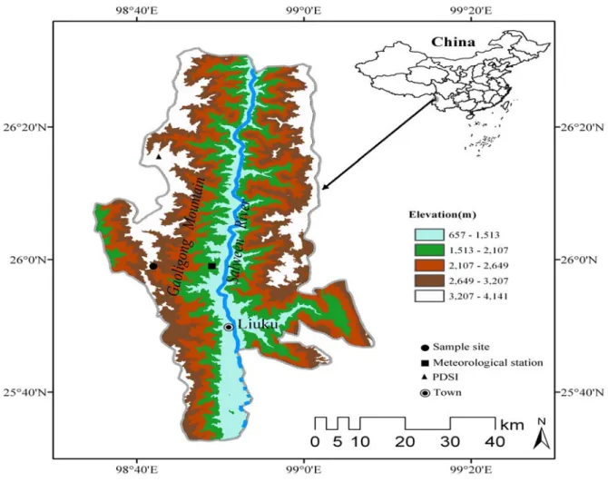
Fig. 1. Map showing the tree-ring sampling site and associated climate records in Gaoligong Mountain of northwestern Yunnan, China. Table 1. Tree-ring sites and meteorological station location in Gaoligong Mountain of northwestern Yunnan, China.
Site Lat (N)/Long (E) Elevation (m) Sample species Sample depth Length Period
PM 25.59 °N, 98.42 °E 2930 Tsuga dumosa 28 1600–2005 430
PM 25.58 °N, 98.40 °E 2980 Abies georgei 31 1597–2005 433
LS 25.59 °N, 98.52 °E 1199 – – 1958–2002 45
PDSI 26.25 °N, 98.75 °E – – – 1958–2002 55
PM, Pima country; LS, Lushui meteorological station; PDSI, the selected PDSI grid developed by Dai et al., (2004)
After air drying, mounting and sanding in the laboratory, each ring width of all the samples was measured to 0.001 mm in precision using a Velmex tree-ring measurement system. The tree-ring series were carefully crossdated following standard dendrochronological techniques (Fritts, 1976), and the quality of visual cross dating was further checked by COFECHA program
(Holmes, 1983). These methods ensured exact dating for each annual ring width. Some cores of poor quality (e.g. fragmented, rotten, and not cross-datable) were discarded from further analyses. Finally, 59 increment cores were selected for further analysis, and seven hemlock cores and four fir cores were excluded.
WINTER DROUGHT VARIATIONS BASED ON TREE-RING DATA 2471
Prior to standardization, the variance of each series was stabilized using a data-adaptive power transformation based on the individual mean and standard deviation (Cook et at., 1997). Long-term biological trends were removed from the ring-width series using ARSTAN program (Cook & Kairiukstis, 1990). Conservative methods of detrending, using negative-exponential or straight-line curve fits, were employed in the standardization process in order to retain low-frequency information related to climate. A cubic spline with a 50% frequency-response cutoff equal to 67% of the series length was also used in a few cases (9 out of the 59 cores) when anomalous growth trends occurred. Deviations of the individual measurement series from the detrending curves were calculated as residuals. Dimensionless indices were averaged to chronologies by computing the biweight robust mean in order to reduce the influence of outliers (Cook & Kairiukstis, 1990). To reduce the potential influence of weakly replicated portions with increasing age, the variance of the chronology was stabilized (Osborn et al., 1997) and truncated at <5 series. In order to maximize potential of low-frequency information among individual tree-ring series, the so-called standard chronology was retained for analysis.
A common period analysis (1874–1999 for fir chronology and 1832–1997 for hemlock chronology) conducted by the use of mean inter-series correlation (Rbar) and the variance in first eigenvector (VFE), and several descriptive statistics were calculated for the standard chronologies. Mean sensitivity (MS) quantifies the annual variation in growth between two adjacent rings
(Fritts, 1976), and signal-to-noise ratio (SNR) serves as an expression of the strength of the observed common signal among trees. EPS was calculated using a 30-year moving window with 15-year overlaps, and a level of 0.85 in EPS is usually employed to determine the most reliable period of the chronology.
Data analysis: The climate data used in this study include
local meteorological records (i.e. monthly mean, minimum, maximum temperature and precipitation) as well as the monthly PDSI data developed by Dai et al., (2004) (Table 1). The local instrumental data covering the period 1958–2002 were obtained from the nearby Lushui meteorological station (Fig. 2), and the instrumental data were kindly provided by China Meteorological Bureau (http://cdc.cma.gov.cn/). The PDSI dataset developed by Dai et al., (2004) is available on a 2.5° × 2.5° grid. The grid point nearest to our sampling site, with a time span of 1948–2003, was used in this study. Climate-growth relationships were determined using correlation analyses in the DendroClim 2002 program (Biondi & Waikul, 2004), undertaken over maximum periods of overlap between the chronology and climate data. Correlations between tree-ring chronology and climate data were calculated on a 19 month dendroclimatic year beginning in March of the prior growth year to September of the radial growth year. The ‘year’ included several months leading up to the growth season, which allows for the identification of prior-year climatic preconditioning effects on radial growth.
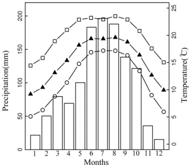
Fig. 2. Monthly variation of total precipitations (bars), mean maximum temperature (line with squares), and mean temperature (line with triangles) and mean minimum temperature (line with circles) for Lushui Meteorological Station, calculated for the period of 1958–2002.
A linear model was developed to reconstruct climatic variable by using tree rings as the predictor. The leave-one-out cross validation (Michaelsen, 1987) was employed to verify our reconstruction, since the available meteorological data were too short to carry out a robust split-sample calibration. Evaluative statistics include the Pearson's correlation coefficient (r), reduction of error (RE), product mean test (Pmt), sign test (ST) and Durbin–Watson statistic (DW) applied to the regression residuals (Fritts, 1976; Cook et al., 1994). The RE statistic tests whether the model provides a more skillful estimate than the mean climatology of the calibration period, with positive values indicating skill of the regression model. ST statistic counts the number of agreements and disagreements between the reconstructed and the instrumental climate data, while Pmt measures the level of agreement between the actual and estimated values and takes into account the sign and magnitude of departures from the calibration average. The DW statistic tests for autocorrelation in the residuals between model and target climate data.
Results
Statistical characteristics of the chronologies: A
404-year (1600–2004) and a 407-404-year (1597–2004) long ring-width chronologies were developed for hemlock (T.
dumosa) and fir (A. georgei), respectively (Fig. 3). Statistics characteristics of the chronologies showed standard deviation (SD) and MS were about 0.45 and 0.25, indicating a relatively stronger signal in the higher-frequency domain of the chronologies (Table 2). The
value of AC1 was 0.56–0.65, reflecting considerably large biological memory (i.e., persistence of previous year growth conditions) in the ring-width parameter. Common interval analysis for the chronologies showed high SNR (3.57–4.75), VFE (18.75–23.6%) and Rbar (0.34–0.41), indicating more homogeneous data contained in the common interval time span of the tree ring cores. EPS with the threshold value of 0.85, indicating sufficient chronology quality, was considered to be acceptable in 1761–2004 for hemlock chronology and 1795–2004 for fir chronology. Median segment length among the samples of hemlock and fir were 205 years and 254 years, indicating that the tree-ring data could resolve low-frequency variations with a realizable limit of approximately 200– 250 years (Cook et al., 1995; D'Arrigo et al., 2005). All statistics discussed above confirmed that our chronologies contained strong common signals and should be suitable for growth-climate relationship studies.
Similar growth patterns between hemlock and fir chronologies (correlation coefficient during the common interval is 0.528) indicated that they were influenced by the same climatic factors in spite of a 50 m difference in elevation (Fig. 3). To evaluate coherence among the two resulting ring width chronologies, principal component analysis (PCA) was performed over the 1795–2004 common period (the period with a threshold of EPS>0.85 for both chronologies). The first eigenvector (PC1) accounted for nearly 75% of the overall variance in the chronologies. It showed common positive loadings, ranging from 0.75–0.84 of the chronologies. Further considering the close locations of the two sites and the high environmental homogeneity, the score of PC1 can be utilized for growth/climate response analysis and then indicate regional climate variability.
Fig. 3. Plot of tree-ring standard chronologies, the running expressed population signal (EPS) and the sample size. The EPS was calculated using a 30-year window that lags 15 years. In the upper section of the graph, horizontal dashed line denotes the threshold level of EPS while vertical dashed lines indicate the years with an acceptable EPS for the chronologies.
Table 2. Statistics of hemlock (Tsuga dumosa) and fir (Abies georgei) chronologies in Gaoligong Mountain of northwestern Yunnan, China.
Chronology SD MS AC1 SNR* VFE* Rbar* EPS>0.85
Tsuga dumosa 0.426 0.238 0.562 4.75 23.6% 0.413 1761
Abies georgei 0.46 0.243 0.651 3.57 18.75% 0.344 1795
SD, standard deviation; MS, mean sensitivity; AC1, first-order autocorrelation; Rbar, mean inter-series correlations; EPS, expressed population signal; *, Calculation for the common intervals i.e., 1832–1997 for T. dumosa and 1874–1999 for A. georgei, respectively.
WINTER DROUGHT VARIATIONS BASED ON TREE-RING DATA 2473
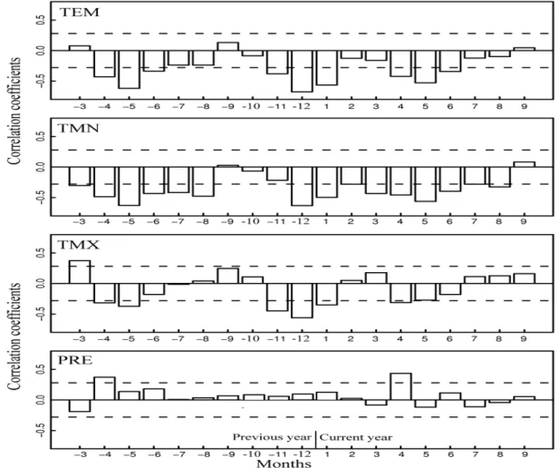
Climate and tree-ring width relationship: Correlation
analysis between PC1 of the chronologies and climate data indicated that temperature was a main factor influencing the radial growth. A striking feature was that correlation coefficients between temperature (mean, maximum and minimum temperatures) and PC1 were negative in most months, with most significant correlations occurring in winter season (previous November to current January), following by current (April to June) and previous (previous April to previous June) spring seasons. We also found that PC1 had a close correlation with mean and minimum temperature, with similar but weaker correlations for maximum temperature (Fig. 4). Compared with the predominant impact of temperature, PC1 appeared much weaker correlations with precipitation, with the exception of positive correlations occurred in current and previous April.
It is suggested that both temperature and precipitation played important roles in modulating tree growth in the study area, as both affect soil moisture availability. Palmer drought severity index (PDSI; Palmer, 1965), as a means to measure moisture conditions, is considered to be most suitable for describing soil moisture and has been extensively used as the drought indicator in dendroclimatology (Cook et al., 1999; Esper et al., 2007;
Li et al., 2007; D'Arrigo et al., 2008; Davi et al., 2009). Fan et al., (2008a) and Fang et al., (2009a) also showed the potential calibration of tree rings with PDSI and subsequent drought reconstructions in the central Henguan Mountains. Considering all the facts mentioned so far, correlations of PC1 with monthly PDSI over their common period 1948–2003 were further analyzed.
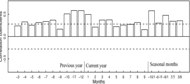
As shown in Fig. 5, most of the correlations were significant at the 95% confidence level, except those in March, September in the previous year and February, May, September in the current year. Peak correlations occurred in October of the previous year to January in the current year (r = 0.5–0.59), followed by the correlations in March to April in the current year (r = 0.36–0.38) and July to August in the previous year(r = 0.35–0.38). Seasonally averaged PDSI might be more representative of moisture conditions than just one single month (Cook et al., 1999). Therefore, we tested different seasonal combinations of PDSI for correlation analysis. The highest correlation was found in winter season (previous October to current January) (r = 0.617, p < 0.01), which agreed well with the monthly correlations in Fig. 4. Thus winter PDSI should be an appropriate climate parameter to be reconstructed by using PC1 as predictor variable.
Fig. 4. Correlation analysis between PC1 and climate, using monthly mean temperature (TEM), minimum temperature (TMN), maximum temperature (TMX) and precipitation (PRE). Correlations were calculated from March of the previous year to September of the current year over the common period (1958–2002). Horizontal dashed lines denote the 95% significance levels. Numbers on x-axis refer to monthly values from prior March (-3) to current September (9).
Fig. 5. Correlation analyses between PC1 and PDSI. Correlations were calculated from March of the previous year to September of the current year over the common period (1948–2003). Horizontal dashed lines denote the 95% significance levels. Numbers on x-axis refer to monthly values from previous March (-3) to current September (9), and seasonal means of previous October to January (-10/1), previous June to prior October (-6/-9), previous June to January (-6/1), March to May (3/5) and March to August (3/8).
Calibration and verification of the reconstruction model: A linear regression model (Y = 0.542X – 0.282)
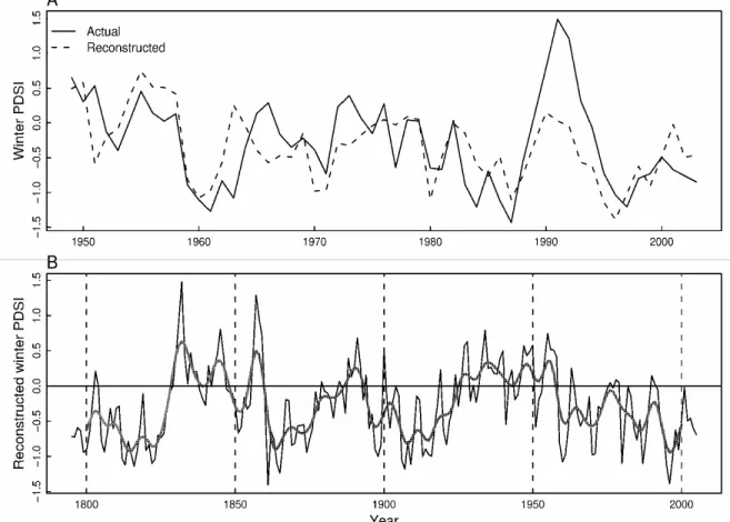
was developed to reconstruct the history of winter PDSI for the Gaoligong Mountain region. During the common period of PC1 and PDSI (1948–2003), the reconstruction accounted for 38.1% of the actual PDSI variance (Table 3). As shown in Fig. 6(A), our reconstruction successfully captured both high- and low-frequency variations of actual PDSI availability. The reduction of error (RE) was
positive (0.34), indicating predictive skill of the regression model (Cook et al., 1994) (Table 3). The results of the sign-test (ST) and product mean test (Pmt) further demonstrated the validity of our regression model. For additional verification, Durbin-Watson statistic (DW) was about 1.75, indicating insignificant autocorrelation in the model residuals and target climate data. All these statistics demonstrated the reliability of our regression model.
Table 3. Leave-one-out cross-validation statistics of climate-growth model for climate reconstruction in Gaoligong Mountain of northwestern Yunnan, China.
r r2 radj2 RE ST Pmt DW
Calibration 0.617 0.381* 0.368* – – –
Verification 0.585 0.342* 0.33* 0.34 38+/15–* 4.235* 1.75
Note that r is the correlation coefficient, r2
is the explained variance, radj
2 is the adjustment explained variance, RE is the Reduction
of Error statistic, ST is sign test, Pmt is the t value derived using the product mean test and DW is Durbin–Watson statistic. * means the significant level p<0.05
Winter PDSI reconstruction: Our reconstruction
quantitatively extended the drought history in Gaoligong Mountain back to A.D.1795, providing a longer background to evaluate local drought variability (Fig. 6B). The mean value of our PDSI reconstruction was −0.28, which was within the scale of the defined normal moisture status (PDSI = 0.0 ± 0.5) (Palmer, 1965). The reconstruction showed that wet periods prevailed in A.D.1827–1861, 1880–1896 and 1922–1961. Extremely wet years (> 1.5 SD, PDSI > 0.531) occurred in A. D. 1831–1832, 1845, 1857–1859, 1891, 1927–1928, 1934, 1947, 1950 and 1955. In contrast, the intervals A.D. 1795–1826, 1862–1879, 1897–1921 and 1962 to present were relatively drought. Extremely drought years (< 1.5 SD, PDSI < 1.096) were almost equally frequent with extremely warm years and were concentrated on the intervals A.D. 1813, 1816, 1822, 1861, 1864–1865, 1907, 1909, 1980, 1987 and 1995–1996, respectively.
Discussions
The association of tree growth with climate: Results of
correlation analysis show that ring-width is strongly negatively correlated with winter (prior October to January) temperature, indicating winter temperature do seem to play a decisive role in modulating mean climate-tree growth relationships in this region. The negative relationship of ring width and winter temperature contrasts sharply with the positive relationship widely reported for the adjoined regions, such as the central Hengduan Mountains (Fan et al., 2009a, 2009b, 2010), western Sichuan Plateau (Shao & Fan, 1999) and northeastern Tibetan Plateau (Bräuning, 2001; Gou et al., 2007; Liang et al., 2008). Our result substantiates the hypothesis that anomalous warm climate in winter can result in loss of frost resistance and sap ascent during a prolonged thaw period, at a time that the tree is normally dormant and fully frost hardy(Auclair et al., 1996). This
WINTER DROUGHT VARIATIONS BASED ON TREE-RING DATA 2475
increases the probability of extreme weather events that damage the tree by sudden, severe freezing (Yin et al., 1994). Subsequent to these episodes of major climatic injury and dieback, the tree is hypersensitive to drought and heat stresses, and to a plethora of pathogens and insect pests (Auclair et al., 1996; Payette et al., 1996). Defoliation and bud mortality caused by those damages will deplete the pool of stored carbohydrates and reduce a
tree’s potential for future growth and photosynthetic capture, thus reduce radial growth during the following year (Lazarus et al., 2004; Misson et al., 2004). Consistent to our result, Payette et al., (1996) and Tardif et al., (2001) also found that anomalous mild winters were associated with reduced sugar maple in southwestern Quebec and could be connected to dieback episodes observed in the late 20th century.
Fig. 6. A, Actual (line) and reconstructed (dashed line) winter PDSI (previous October to current January) during their common period 1948–2003. The estimation explains about 38% of the actual PDSI variance in this common period. B, The reconstruction of winter PDSI (previous October to current January) in Gaoligongshan Mountain, plotted annually from 1795 to 2004, along with a smoothed 11-year moving average.
Besides winter temperature, tree rings also respond negatively to temperature in other months, notably apparent for spring seasons in the prior and current years. The overall negative correlation to temperature throughout the year can be explained by the fact that plant respiration increases exponentially with increasing temperature and results in a higher loss of assimilated carbon as a source of energy (Fitter & Hay, 1981; Barber et al., 2000; Fichtler et al., 2004). Consequently, trees will experience decreased radial growth carbon uptake. Temperature-induced drought stress is therefore the most probable interpretation for the consistently positive correlations between tree rings and PDSI. The positive relationship between the tree-ring data and April precipitation in prior and current spring seasons suggests a higher susceptibility to water stress in the early growing season, and the time of shoot growth and leaf expansion (Tardif & Bergeron, 1997). Fan et al., (2008) also underlined the importance of spring precipitation for radial increment in central Hengduan Mountains.
Changes in reconstructed PDSI over time: The
reconstructed winter PDSI allows us to identify and analyze the patterns of drought and wetness over past 210 years in the Gaoligong Mountain region, northwestern Yunnan of China. In order to identify whether our reconstruction represents features that are coherent over large spatial scale, we compare our reconstruction with other drought reconstructions from the nearby regions. The closest other such record available for comparison is a spring (March–May) drought reconstruction for the central Hengduan Mountains based on ring-width data (Fan et al., 2008a) of four coniferous species, located at about 250 km northeast to our sample site. Although the tree ring data reported by Fan et al., (2008a) was pre-whitened by the autoregressive model to highlight the high-frequency variations, there are some pronounced similarities between the two series that should be noted, especially at interdecadal scale. The dry climates during the 1790s–1820s, 1860s–1870s, 1800s–1810s and 1960s–
1980s (Fig. 6B) in this study coincides reasonably well with dry episodes in the central Hengduan Mountains. The wet episodes prominent in our series, namely 1830s– 1850s, 1880s–1890s and 1920s–1950s, are also characterized by pluvial periods in the study by Fan et al., (2008a). So, there appeared to be some reasonable large-scale support of the interdecadal drought changes indicated in our reconstruction. It is interesting to note that our reconstruction, on average, shows more low frequency trend in comparison to the series by Fan et al., (2008a). Those differences between the two series possibly reflect the difference in the processing techniques on tree ring data, and different seasonal drought concerned might provide the additional explanation.
Several inferences in surrounding areas about dry and wet phases during the past centuries have been made using tree-ring records (Ahmed & Naqvi, 2005; Singh et al., 2006; Treydte et al., 2006; Buckley et al., 2007; Gou et al., 2007; Huang & Zhang, 2007; Sano et al., 2008; Fang et al., 2009b; Ahmed et al., 2009, 2010), and these may be used to further evaluate the validity of our reconstruction. The dry climates in the 1790s–1820s and1860s–1870s are also detected as dry periods in the northwestern Tibetan plateau (Huang & Zhang, 2007) and the western Himalaya (Singh et al., 2006), but drought reconstructions of Indochina (Buckley et al., 2007; Sano et al., 2008) reveal persistently less arid conditions in this two intervals. The wet epochs in the 1830s–1850s in our study region correspond with relatively wet conditions for the western Himalaya (Singh et al., 2006). It is surprising that no extreme drought events in our reconstruction correspond with the Late Victorian Great Drought of 1876 to 1878, which was felt across all areas of Monsoon Asian as indicated in the recently developed Monsoon Asia Drought Atlas (MADA) (Cook et al., 2010). Since the turn of the 20th century, an impressive feature of the reconstruction is the cumulative drought at the interval 1897–1921, and this coincides with the findings of Singh et al., (2006) who report that the early 20th century in western Himalaya was characterized as an obvious drought period. It is also noteworthy that this long-term drought in this stand appears to precede the well-documented 1920s drought scenario in northern China (Liang et al., 2008) by several years, and tree-ring record in the central Hengduan Mountains (Fan et al., 2008) attained the similar result. The most pluvial period in the past 210 years occurs during 1922–1961, especially for 1927–1928, 1933–1934, 1947–1950 and 1955–1958. 1934 and 1955 are the extremely wet years in our reconstruction. This finding is in line with evidence from the tree-ring record in the northeastern Tibetan plateau indicating a significant wet period in 1930s–1950s (Huang & Zhang, 2007). However, this wet period in our study area was not significant in the central headwater area of the Yellow River in China (Gou et al., 2007), but relatively dry for in western Himalaya(Singh et al., 2006) and teak ring width record from northwest Thailand (Buckley et al., 2007).
As indicated by our reconstruction, the dry epoch in 1962–2004 is the most severe and long-lasting drought in the study area since A. D. 1795, and abrupt growth decreases occurred in 1970–1971, 1980, 1995–1996 and 1999. The tree ring records in the northeastern Tibetan plateau and its vicinity (Gou et al., 2007; Fang et al.,
2009b) have been interpreted as evidence for severe drought appropriately at 1960s–1990s, and this is in accord with our result. However, this drought is not uniformly severe in a teak ring width record from northwest Thailand (Buckley et al., 2007) and cypress chronology in northern Vietnam (Sano et al., 2008). Based on a newly developed daily precipitation dataset of 740 stations in China, Zhai et al.(2005) have evidenced a drying trend in southwest China for the period 1951– 2000. Our reconstruction is in basic agreement with this assessment. As further evidenced by the actual PDSI data (Fig. 6A), this drying trend in second half of 20th century has basically persisted up to 2004 and may go further. An outstanding example is a severe drought from September 2009 to May 2010 experienced by southwest China, which has been ascribed to 60% less rainfall than normal (Qiu, 2010). This elevated aridity marks the worst drought pale during the instrumental period and has created disastrous impacts on human populations and ecosystems in southwest China.
Conclusions
The results of our study indicate the feasibility of combining tree rings and the PDSI for drought reconstructions in Gaoligong Mountain, northwestern Yunnan of China. This reconstruction provides extension and enhancement of the climate record for this region with limited instrumental data. Preliminary results of our reconstruction for the southern Gaoligong Mountain have revealed regional drought variations during 1795–2004. As indicated in our study, the most noteworthy feature of the reconstruction is the persistent drought trend at the late 20th century. The decadal-scale drought variability in our study matches reasonably well with other drought series from the adjoined regions, suggesting the fidelity of the local drought sensitivity of our tree-ring data.
However, our preliminary drought reconstruction is only based on samples from two sites and covers only the last two centuries. Therefore, more expanded and improved dendroclimatological investigation in near future will likely to draw a superior climate history of this climatically sensitive region. Improving knowledge regarding long-term drought changes and potential large-scale trends will benefit the understanding of current climate status of northwestern Yunnan under the context of global warming scenarios, which have greatly altered the hydrological cycle (Treydte et al., 2006). These efforts will also help natural resource managers apply more sustainable strategies for local water resources in the future (Li et al., 2007; Touchan et al., 2007).
Acknowledgements
This research was supported by the National Natural Science Foundation of China project 40631002 and 40890051, and by the Chinese Academy of Sciences project KSCX-YW-Z-1022. We thank Forestry Bureaus of Nujiang for giving many supports to our field work. We also thank Mrs. Hongyan Qiu for help in the crossdating of tree-ring cores and Dr. Lixin Lü for valuable suggestions and comments about data analysis that improved the manuscript.
WINTER DROUGHT VARIATIONS BASED ON TREE-RING DATA 2477
References
Ahmed, M. and S.H. Naqvi. 2005. Tree-ring chronologies of Picea smithiana (Wall.) boiss., and its quantitative vegetational description from Himalayan range of Pakistan. Pak. J. Bot., 37(3): 697-707.
Ahmed, M., M. Wahab and N. Khan. 2009. Dendroclimatic investigation in Pakistan, using Picea Smithiana (Wall) Boiss., Preliminary Results. Pak. J. Bot., 41(5): 2427-2435. Ahmed, M., N. Khan and M. Wahab. 2010. Climate response
function analysis of Abies pindrow(Royle) Spach. preliminary results. Pak. J. Bot., 42(1): 165-171.
Allan, R.J., J. Lindesay and D.E. Parker. 1996. El Niño-Southern Oscillation and climatic variability. CSIRO Publishing, Melbourne.
Auclair, A.N.D., J.T. Lill and C. Revenga. 1996. The role of climate variability and global warming in the dieback of Northern Hardwoods. Water Air Soil Poll., 91(3-4): 163-186.
Barber, V.A., G.P. Juday and B.P. Finney. 2000. Reduced growth of Alaskan white spruce in the twentieth century from temperature-induced drought stress. Nature, 405: 668-673.
Biondi, F. and K. Waikul. 2004. DendroClim2002: a C++ program for statistical calibration of climate signals in tree-ring chronologies. Computat. Geosci., 30: 303-311. Boos, W.R. and Z.M. Kuang. 2010. Dominant control of the
South Asian monsoon by orographic insulation versus plateau heating. Nature, 463(7278): 218-222.
Bräuning, A. 2001. Climate history of the Tibetan Plateau during the last 1000 years derived from a network of Juniper chronologies. Dendrochronologia, 19(1): 127-137. Buckley, B.M., K. Palakit, K. Duangsathaporn, P. Sanguantham
and P. Prasomsin. 2007. Decadal scale droughts over northwestern Thailand over the past 448 years: links to the tropical Pacific and Indian Ocean sectors. Clim. Dynam., 29(1): 63-71.
Buntaine, M.T, R.B. Mullen and J.P. Lassoie. 2006. Human use and conservation planning in alpine areas of northwestern Yunnan, China. Environ. Develop. Sustain., doi: 10.1007/s10668-10006-19025-10668.
Charles, C.D., D.E. Hunter and R.G. Fairbanks. 1997. Interaction between the ENSO and the Asian monsoon in a coral record of tropical climate. Science, 277(5328): 925-928.
Cook, E.R. and L.A. Kairiukstis. 1990. Methods of dendrochronology: applications in the environmental sciences. Kluwer Academic Publishers, dordrecht, Netherlands.
Cook, E.R., D.M. Meko and C.W. Stockton. 1997. A new assessment of possible solar and lunar forcing of the bidecadal drought rhythm in the western United States. J. Climate, 10(6): 1343-1356.
Cook, E.R., D.M. Meko, D.W. Stahle and M.K. Cleaveland. 1999. Drought reconstructions for the continental United States. J. Climate, 12(4): 1145-1162.
Cook, E.R., K.J. Anchukaitis, B.M. Buckley, R.D. D'Arrigo RD, G.C. Jacoby GC and W.E. Wright. 2010. Asian monsoon failure and megadrought during the last millennium. Science, 328(5977): 486-489.
Cook, E.R., K.R. Briffa and P.D. Jones. 1994. Spatial regression methods in dendroclimatology: a review and comparison of two techniques. Int. J. Climatol., 14: 379-402.
Cook, E.R., K.R. Briffa, D.M. Meko, D.A. Graybill and G. Funkhouser. 1995. The segment length curse in long tree-ring chronology development for paleoclimatic studies. Holocene, 5(2): 229-237.
Dai, A., K.E. Trenberth and T. Qian. 2004. A global dataset of Palmer Drought Severity Index for 1870-2002: Relationship with soil moisture and effects of surface warming. J. Hydrometeorol., 5: 1117-1130.
D'Arrigo, R. and J.E. Smerdon. 2008. Tropical climate influences on drought variability over Java, Indonesia. Geophys. Res. Lett., 35(5): L05707, doi:05710.01029/02007GL032589. D'Arrigo, R., E. Mashig, D. Frank, R. Wilson and G. Jacoby.
2005. Temperature variability over the past millennium inferred from Northwestern Alaska tree rings. Clim. Dynam., 24(2-3): 227-236.
Davi, N.K., G.C. Jacoby, R.D. D'Arrigo, N. Baatarbileg, J.B. Li and A.E. Curtis. 2009. A tree-ring-based drought index reconstruction for far-western Mongolia: 1565-2004. Int. J. Climatol., 29(10): 1508-1514.
Esper, J., D. Frank, U. Büntgen, A. Verstege, Jr. Luterbacher and E. Xoplaki. 2007. Long-term drought severity variations in Morocco. Geophys. Res. Lett., 34(L17702): doi:10.1029/2007GL030844.
Fan, Z.X., A. Bräuning and K.F. Cao. 2008a. Tree-ring based drought reconstruction in the central Hengduan Mountains region (China) since A.D. 1655. Int. J. Climatol., doi:10.1002/joc.1689.
Fan, Z.X., A. Bräuning and K.F. Cao. 2008b. Annual temperature reconstruction in the central Hengduan Mountains, China, as deduced from tree rings. Dendrochronologia, 26(2): 97-107.
Fan, Z.X., A. Bräuning, K.F. Cao and S.D. Zhu. 2009a. Growth-climate responses of high-elevation conifers in the central Hengduan Mountains, southwestern China. Forest Ecol. Manag., 258(3): 306-313.
Fan, Z.X., A. Bräuning, Y. Bao and K.F. Cao. 2009b. Tree ring density-based summer temperature reconstruction for the central Hengduan Mountains in southern China. Global. Planet. Change, 65(1-2): 1-11.
Fan, Z.X., A. Bräuning, Q.H. Tian, B. Yang and K.F. Cao. 2010. Tree ring recorded May-August temperature variations since AD 1585 in the Gaoligong Mountains, southeastern Tibetan Plateau. Palaeogeogr. Palaeocl., 296(1-2): 94-102. Fang, K.Y., X.H. Gou, F.H. Chen, J.B. Li, R. D'Arrigo, E. Cook,
T. Yang and N. Navi. 2009a. Reconstructed droughts for the southeastern Tibetan Plateau over the past 568 years and its linkages to the Pacific and Atlantic Ocean climate variability. Clim. Dynam., doi: 10.1007/s00382-00009-00636-00382.
Fang, K.Y., X.H. Gou, F.H. Chen, M.X. Yang, J.B. Li, M.S. He, Y. Zhang, Q.H. Tian and J.F. Peng. 2009b. Drought variations in the eastern part of northwest China over the past two centuries: evidence from tree rings. Clim. Res., 38(2): 129-135.
Feng, J.M., X.D. Dong, C.D. Xu and F.S. Zha. 2009. Effects of sampling scale on latitudinal patterns of species diversity in seed plants in northwestern Yunnan, China. Biodiv. Sci., 17(3): 266-271.
Fichtler, E., V. Trouet, H. Beeckman, P. Coppin and M. Worbes. 2004. Climatic signals in tree rings of Burkea africana and Pterocarpus angolensis from semiarid forests in Namibia. Trees, 18(4): 442-451.
Fitter, A.H. and R.K.M. Hay. 1981. Environmental physiology of plants. Academic, London.
Frenzel, B., A. Bräuning and S. Adamczyk. 2003. On the problem of possible last-glacial forest-refuge-areas within the deep valleys of Eastern Tibet. Erdkunde, 57: 182-198. Fritts, H.C. 1976. Tree rings and climate. Academic Press, New
York.
Gou, X.H., F.H. Chen, G. Jacoby, E. Cook, M.X. Yang, H.F. Peng and Y. Zhang. 2007. Rapid tree growth with respect to the last 400 years in response to climate warming, northeastern Tibetan Plateau. Int. J. Climatol., 27(11): 1497-1503.
Holmes, R.L. 1983. Computer-assisted quality control in tree-ring dating and measurement. Tree-tree-ring Bull., 43: 69-78. Huang, J.G. and Q.B. Zhang. 2007. Tree rings and climate for
the last 680 years in Wulan area of northeastern Qinghai-Tibetan Plateau. Climatic Change, 80(3-4): 369-377.
Kumar, K.K., B. Rajagopalan and M.A. Cane. 1999. On the weakening relationship between the Indian monsoon and ENSO. Science, 284(5423): 2156-2159.
Lazarus, B.E., P.G. Schaberg, D.H. DeHayes and G.J. Hawley. 2004. Severe red spruce winter injury in 2003 creates unusual ecological event in the northeastern United States. Can. J. Forest. Res., 34(8): 1784-1788.
Li, J.B., F. Chen, E.R. Cook, X.H. Gou and Y.X. Zhang. 2007. Drought reconstruction for north central China from tree rings: the value of the Palmer drought severity index. Int. J. Climatol.,27(7): 903-909.
Li, X.W. and J. Li. 1993. A preliminary floristic study on the seed plants from the region of Hengduan Mountain. Acta Bot. Yunnan., 15(3): 217-231.
Liang, E.Y., X.M. Shao and N.S. Qin. 2008. Tree-ring based summer temperature reconstruction for the source region of the Yangtze River on the Tibetan Plateau. Global Planet. Change, 61(3-4): 313-320.
Liu, J.H., P.Z. Zhang, H. Cheng, F.H. Chen, X.L. Yang, D.Z. Zhang, J. Zhou, J.H. Jia, C.L. An, W. Sang and R.J. Kathleen. 2008. Asian summer monsoon precipitation recorded by stalagmite oxygen isotopic composition in the western Loess Plateau during AD1875-2003 and its linkage with ocean-atmosphere system. Chin. Sci. Bull. 53(13): 2041-2049.
Michaelsen, J. 1987. Cross-validation in statistical climate forecast models. J. Appl. Meteorol., 26(11): 1589-1600. Misson, L., C. Rathgeber and J. Guiot. 2004. Dendroecological
analysis of climatic effects on Quercus petraea and Pinus halepensis radial growth using the process-based MAIDEN model. Can. J. Forest. Res., 34: 888-898.
Myers, N., R.A. Mittermeier, C.G. Mittermeier, G.A.B. da Fonseca and J. Kent. 2000. Biodiversity hotspots for conservation priorities. Nature, 403(6772): 853-858. Osborn, T.J., K.R. Briffa and P.D. Jones. 1997. Adjusting
variance for sample size in tree-ring chronologies and other regional mean timeseries. Dendrochronologia, 15: 89-99. Overpeck, J.T. and J.E. Cole. 2007. Climate change - Lessons
from a distant monsoon. Nature, 445(7125): 270-271. Palmer, W.C. 1965. Meteorological Drought. Weather Bureau
Res. Paper 45. U.S. Department of Commerce, Washington, D C.
Payette, S., M.J. Fortin and C. Morneau. 1996. The recent sugar maple decline in southern Quebec: Probable causes deduced from tree rings. Can. J. Forest. Res., 26(6): 1069-1078. Qiu, J. 2010. China drought highlights future climate threats.
Nature, 465: 142-143.
Sano, M., B.M. Buckley and T. Sweda. 2008. Tree-ring based hydroclimate reconstruction over northern Vietnam from Fokienia hodginsii: eighteenth century mega-drought and
tropical Pacific influence. Clim. Dynam., doi: 10.1007/s00382-00008-00454-y.
Shao, X.M. and J.M. Fan. 1999. Past climate on west Sichuan Plateau as reconstructed from ring-widths of Dragon Spruce. Quaternary Sci. 19(1): 81-89.
Sherman, R., R. Mullen, H.M. Li, Z.D. Fang and Y. Wang. 2008. Spatial patterns of plant diversity and communities in Alpine ecosystems of the Hengduan Mountains, Northwest Yunnan, China. J. Plant Ecol. 1(2): 117-136.
Singh, J., W. K. Park and R.R. Yadav. 2006. Tree-ring-based hydrological records for western Himalaya, India, since a.d. 1560. Clim. Dynam., 26(2-3): 295-303.
Tardif, J. and Y. Bergeron. 1997. Comparative dendroclimatological analysis of two black ash and two white cedar populations from contrasting sites in the Lake Duparquet region, northwestern Quebec. Can. J. Forest. Res., 27(1): 108-116.
Tardif, J., J. Brisson and Y. Bergeron. 2001. Dendroclimatic analysis of Acer saccharum, Fagus grandifolia, and Tsuga canadensis from an old-growth forest, southwestern Quebec. Can. J. Forest. Res., 31(9): 1491-1501.
Touchan, R., U. Akkemik, M.K. Hughes and N. Erkan. 2007. May-June precipitation reconstruction of Southwestern Anatolia, Turkey during the last 900 years from tree rings. Quaternary Res., 68(2): 196-202.
Treydte, K.S., G.H. Schleser, G. Helle, D.C. Frank, M. Winiger, G.H. Haug and J. Esper. 2006. The twentieth century was the wettest period in northern Pakistan over the past millennium. Nature, 440: 1179-1182.
Wang, Z.H., A.P. Chen, S.L. Piao and J.Y. Fang. 2004. Pattern of species richness along an altitudinal gradient on Gaoligong Mountains, Southwest China. Biodiv. Sci., 12(1): 82-88.
Wigley, T.M., K.R. Briffa and P.D. Jones. 1984. On the average value of correlated time series, with applications in dendroclimatology and hydrometeorology. J. Clim. App. Meteorol., 23: 201-213.
Wu, X.D., Z.Y. Li and L. Sun. 1988. A preliminary study on the climatic change of the Hengduan Mountains area since 1600 A.D. Adv. Atmos. Sci., 5(4): 437-443.
Yin, X.W., N.W. Foster, I.K. Morrison and P.A. Arp. 1994. Tree-ring based growth analysis for a Sugar Maple stand - relations to local climate and transient soil properties. Can. J. Forest. Res., 24(8): 1567-1574.
Ying, J.S. 1996. Areography of the endemic genera of seed plants in China. Acta Phytotaxonomica Sinica, 34(5): 479-485.
Zhai, P.M., X.B. Zhang, H. Wan and X.H. Pan. 2005. Trends in total precipitation and frequency of daily precipitation extremes over China. J. Climate, 18(7): 1096-1108. (Received for publication 11 March 2010)
View publication stats View publication stats