HAL Id: hal-00298820
https://hal.archives-ouvertes.fr/hal-00298820
Submitted on 13 Mar 2007HAL is a multi-disciplinary open access
archive for the deposit and dissemination of sci-entific research documents, whether they are pub-lished or not. The documents may come from teaching and research institutions in France or abroad, or from public or private research centers.
L’archive ouverte pluridisciplinaire HAL, est destinée au dépôt et à la diffusion de documents scientifiques de niveau recherche, publiés ou non, émanant des établissements d’enseignement et de recherche français ou étrangers, des laboratoires publics ou privés.
Weathering rates and origin of inorganic carbon as
influenced by river regulation in the boreal sub-arctic
region of Sweden
J. Brink, C. Humborg, J. Sahlberg, L. Rahm, C.-M. Mörth
To cite this version:
J. Brink, C. Humborg, J. Sahlberg, L. Rahm, C.-M. Mörth. Weathering rates and origin of inorganic carbon as influenced by river regulation in the boreal sub-arctic region of Sweden. Hydrology and Earth System Sciences Discussions, European Geosciences Union, 2007, 4 (2), pp.555-588. �hal-00298820�
HESSD
4, 555–588, 2007
Weathering rates and origin of inorganic carbon J. Brink et al. Title Page Abstract Introduction Conclusions References Tables Figures ◭ ◮ ◭ ◮ Back Close
Full Screen / Esc
Printer-friendly Version Interactive Discussion
EGU
Hydrol. Earth Syst. Sci. Discuss., 4, 555–588, 2007 www.hydrol-earth-syst-sci-discuss.net/4/555/2007/ © Author(s) 2007. This work is licensed
under a Creative Commons License.
Hydrology and Earth System Sciences Discussions
Papers published in Hydrology and Earth System Sciences Discussions are under open-access review for the journal Hydrology and Earth System Sciences
Weathering rates and origin of inorganic
carbon as influenced by river regulation
in the boreal sub-arctic region of Sweden
J. Brink1, C. Humborg2, J. Sahlberg3, L. Rahm4, and C.-M. M ¨orth1
1
Dept. of Geology and Geochemistry, Stockholm University, 10691 Stockholm, Sweden
2
Dept. of Environmental assessment, Stockholm University, 10691 Stockholm, Sweden
3
SMHI, Swedish Meterological and Hydrological Institute, Norrk ¨oping, 60176 Norrk ¨oping, Sweden
4
Dept. of Water and Environmental Studies, University of Link ¨oping, 58183 Link ¨oping, Sweden Received: 18 December 2006 – Accepted: 14 February 2007 – Published: 13 March 2007 Correspondence to: C.-M. M ¨orth (magnus.morth@geo.su.se)
HESSD
4, 555–588, 2007
Weathering rates and origin of inorganic carbon J. Brink et al. Title Page Abstract Introduction Conclusions References Tables Figures ◭ ◮ ◭ ◮ Back Close
Full Screen / Esc
Printer-friendly Version Interactive Discussion
EGU
Abstract
Major environmental stressors of boreal and sub-arctic rivers are hydrological changes and global warming and both factors will significantly influence the future evolution of the river chemistry in high latitudes. We tested the hypothesis whether lower concen-trations of dissolved constituents observed in regulated rivers come along with lower
5
weathering rates, though specific discharge as a major force for physical erosion and weathering is often higher in regulated river systems. In this study the river chemistry, weathering rates and related carbon dioxide consumption in two large watersheds in the sub arctic region of Sweden, one regulated river (Lule River) and one unregulated river (Kalix River), was investigated. Weathering rates of silicates in the two
water-10
sheds are shown to be different; the silicate weathering rate in Kalix River catchment is almost 30% higher than in the Lule River catchment. This is most likely a result of con-structing large reservoirs in the former river valleys inundating the alluvial deposits and thus decreasing soil/water contact resulting in lower weathering rates. Furthermore, the difference observed in weathering rates between lowland regions and headwaters
15
suggests that weathering in sub arctic boreal climates is controlled by the residence time for soil water rock interactions followed by lithology. The chemistry in the two rivers shows weathering of silicates as the origin for 68% of the inorganic carbon in the Lule River and 74% for Kalix River.
The study clearly shows that river regulation significantly decreases alkalinity export
20
to the sea because lower weathering rates gives less carbon dioxide ending up as DIC. By considering sources for inorganic carbon we here report that the inorganic carbon load that originates from respiration of organic matter in soils makes up of 30% and 35% of the total C export for the watersheds of the Kalix River and Lule River, respectively. Therefore, both the inorganic (i.e. the origin of carbon in DIC) and organic
25
carbon load carbon must be considered when studying climate changes on the organic carbon load since effects from increased degradation of organic matter may lead to more weathering (higher production of DIC).
HESSD
4, 555–588, 2007
Weathering rates and origin of inorganic carbon J. Brink et al. Title Page Abstract Introduction Conclusions References Tables Figures ◭ ◮ ◭ ◮ Back Close
Full Screen / Esc
Printer-friendly Version Interactive Discussion
EGU
1 Introduction
River exports of dissolved solids (Si, Ca, Mg, Na, K, HCO3) are closely linked to weath-ering rates of silicate and carbonate minerals (Berner and Berner, 1996; Humborg et al., 1997), and river chemistry supply and retention reflect the processes in soils and along the aquatic continuum. The chemical weathering rate of silicate minerals is
con-5
trolled by a proton promoted part and a ligand promoted part (Amrhein and Suarez, 1988). The most important proton source is carbonic acid originating from either (i) atmospheric CO2 that is dissolved in water, or (ii) respiratory formed CO2 originating from the degradation of organic matter. Other significant factors controlling the weath-ering regime in a river catchment is temperature, specific runoff (Berner and Berner,
10
1996) and physical erosion (Gaillardet et al., 1999).
Comparisons between regulated and non-regulated rivers have often shown that reg-ulated rivers have lower concentrations of major elements (Humborg et al., 2000, 2004) and it has been argued that the lower concentrations in boreal watersheds of northern Sweden are an effect of “less” weathering in the regulated watersheds (Humborg et
15
al., 2004). However, lower concentrations of dissolved constituents in regulated rivers may also be related to a high specific discharge, i.e. a dilution effect, since rivers with a higher specific discharge are preferentially regulated due to higher energy gains. Thus, the main aim of this study was to compare specific weathering yields (mol km−2
yr−1
) between a regulated and an unperturbed watershed, since these can be directly related
20
to possible differences in mass fluxes of major dissolved constituents such as Si and alkalinity. Special emphasis on these weathering related constituents have been given, since the Si export influences diatom production in coastal seas and the alkalinity ex-port (mainly as HCO−3) is a significant variable for regional carbon budgets (Raymond and Cole, 2003).
25
River geochemistry has, in many studies since the pioneering work of Garrels and Mackenzie (1971), given important information about denudation rates of biogeochem-ical elements and the related consumption of atmospheric CO2. Several different
ap-HESSD
4, 555–588, 2007
Weathering rates and origin of inorganic carbon J. Brink et al. Title Page Abstract Introduction Conclusions References Tables Figures ◭ ◮ ◭ ◮ Back Close
Full Screen / Esc
Printer-friendly Version Interactive Discussion
EGU
proaches have been applied for these calculations ranging from studies of small rivers draining one rock type under a given climate condition (Amiotte-Suchet and Probst, 1993; Bluth and Kump, 1994; White and Blum, 1995) to a more global perspective, studying the very large rivers’ geochemistry (Berner et al., 1983; Gaillardet et al., 1997; Holland, 1978). One such study is of the Amazon River by Gaillardet et al. (1999) and
5
Mortatti and Probst (2003). It stressed the importance of physical erosion and its rela-tion to chemical weathering. Similar relarela-tions have also been observed in small catch-ments of the Canadian Shield that is comparable to our investigation area (Millot et al., 2002). In this study we have used a method presented by Mortatti and Probst (2003), to compare (i ) river chemistry, (ii) weathering rates and (iii) consumption/sequestration of
10
CO2during weathering of primary minerals between two boreal sub arctic rivers, Lule River (heavily regulated) and Kalix River (unregulated).
2 Material and methods
2.1 Study area
The Lule and Kalix River basins are located in the sub arctic boreal climate zone of
15
northern Sweden. In total, the two drainage basins cover an area of nearly 50 000 km2 (Lule River: 25 225 km2 and Kalix River: 23 846 km2). The rivers have their headwa-ters in northwest, close to the Norwegian border in the Scandinavian Caledonides, and they flow southward to southeast into the foothills and the boreal forested lowland of the Precambrian basement. They finally drain into the Bothnian Bay (Northern part of
20
the Baltic Sea). Lule River has been regulated since the early 1900s with the latest regulation in the 1970s. In 1923 the Akkajaure reservoir, sometimes also called the Suorva dam, (Fig. 1) was erected, today with water level amplitude of 33 m and an ac-tive storage capacity of 5.9 km3of water. Except for the water regulation of Lule River, the two rivers can be considered as relatively unperturbed due to the sparse
popula-25
HESSD
4, 555–588, 2007
Weathering rates and origin of inorganic carbon J. Brink et al. Title Page Abstract Introduction Conclusions References Tables Figures ◭ ◮ ◭ ◮ Back Close
Full Screen / Esc
Printer-friendly Version Interactive Discussion
EGU
factors in a sub arctic boreal environment. The rivers drain through similar geologi-cal settings, which make them an excellent investigation area to study the effects of hydrological alterations on river biogeochemistry as such.
The mean water discharge for Lule River and Kalix River is 17.6 km3yr−1 and 9.3 km3yr−1
respectively, and the mean annual precipitation for the basins is 698 mm
5
and 544 mm, respectively. Westerly winds from the Atlantic Ocean are prevailing de-livering high precipitation in the headwater of Lule River, with mean precipitation of 1200 mm yr−1
. Rain shadow in the headwater of Kalix River gives a mean annual pre-cipitation of only half of that observed in headwater of Lule River (Table 1). Most of the precipitation is accumulated as snow; this accumulation starts normally in October and
10
ends in June. The snow melts during early summer, which results in high discharge during a short time period (May to July). The cold climate with annual mean air temper-atures close to –2◦C in the headwaters and about +1◦C at the river mouths (Table 1), also leads to high runoff ratios as seen for headwaters in Table 1. The overall hydrology is presented in Table 1.
15
In the headwater areas above the tree line (about 650–800 m a.s.l.), the vegetation cover is mainly alpine heath. Barren lands, with no soil layer, and glaciers are also found. In the forested lowland the soil thickness becomes greater. The soils are dom-inated by till containing minerals like Quartz, K-feldspar, K-mica and Plagioclase with a minor percentage of mafic minerals, like Amphibole, Clorite, Epidote and Pyroxene.
20
Alluvial deposits are found along the main river valleys where soil thickness is found several times larger than in the upstream catchments; this is especially true for the headwaters. The forested lowland is vegetated with shrub and brushwood, deciduous and coniferous forests but also mires. Muddus River is a good example of a lowland tributary to Lule River. It is a typical boreal river influenced by its large amount (42%)
25
HESSD
4, 555–588, 2007
Weathering rates and origin of inorganic carbon J. Brink et al. Title Page Abstract Introduction Conclusions References Tables Figures ◭ ◮ ◭ ◮ Back Close
Full Screen / Esc
Printer-friendly Version Interactive Discussion
EGU
2.2 Geological settings
The Swedish Caledonides are divided into five main tectonic units; the uppermost thrust rocks, the upper thrust rocks, the middle thrust rocks, the lower thrust rocks and the autochthonous sedimentary series in the easterly marginal zone of the Caledonian thrust succession. These sedimentary series consist of phanerozoic sediments, mainly
5
sandstone and shale (Gee and Zachrisson, 1979; Kulling, 1964, 1972, 1982).
The Akkajaure reservoir is situated in a U-shaped valley, surrounded by the mid-dle thrust rocks, the Akkajaure Nappe Complex, which is the dominant tectonic unit in the headwater of Lule River (Gee and Zachrisson, 1979; Kulling, 1964, 1982). Pre-cambrian gneissic granitoids, gneissic granites, granites and syenites, dominate the
10
Precambrian acid igneous rocks of the middle thrust rocks within the headwater of the Akkajaure reservoir (Bj ¨orklund, 1985; Kulling, 1964). In the catchment of Vuojat ¨atno, located in the southwestern part of the basin, the uppermost and upper thrust rocks dominate, here consisting of minerals like mica-schist, calcareous mica-schist, marbles and minor occurrences of amphibolites (Bj ¨orklund, 1985; Kulling, 1964). Calcite and
15
Dolomite occur frequently (Kulling, 1982).
In Sweden the highest mountains are located within the upper thrust complex, e.g. the massif of Akka (2010 m a.s.l.), in the headwater of Lule River, and the Keb-nekaise Mountains (2103 m a.s.l.), in the headwater of Kalix River (Kulling, 1964). The upper thrust rocks are dominating in the headwater of Kalix River. Andreasson and Gee
20
(1989) have identified three major tectonic units in the area: the Tarfala amphibolite, the Storglaci ¨aren gneiss and the Kebne dyke complex. The dyke complex consists of mafic rocks with subordinated metasediment. The mafic rocks of the highest mountains have been referred to as amphibolites by Kulling (1964). However, Andreasson and Gee (1989) suggested that the Kebnekaise massif might be dominated by dolerite. At lower
25
altitudes in the downward succession, the Storglaci ¨aren gneiss is exposed consisting of mylonitic granitoids. Below this rock there is the Tarfala amphibolite. These rock successions are probably similar for the surrounding mountains i.e. Ladtjovagge
val-HESSD
4, 555–588, 2007
Weathering rates and origin of inorganic carbon J. Brink et al. Title Page Abstract Introduction Conclusions References Tables Figures ◭ ◮ ◭ ◮ Back Close
Full Screen / Esc
Printer-friendly Version Interactive Discussion
EGU
ley. The Precambrian crystalline basement is visible in the valley of Tarfalavagge and Ladtjovagge. The percent of main bedrock type in each investigated catchment, except for Killingi in Kaitum River, is presented in Table 2.
3 Sampling and methodology
In the headwaters of the Lule River catchment all main tributaries to the Akkajaure
5
reservoir were sampled; additionally, depth profiles in the reservoir itself were also taken. In the Kalix River Basin samples were taken in the Ladtjo River at the inlet of Lake Paijtas (Fig. 1). The sampling period was from June 2000 to April 2001. Samples were taken at three yearly hydrological events: base flow (winter flow) in April, spring flood in June and summer/autumn flow in September/October.
10
The water samples were collected directly at the surface by syringes or with a Teflon coated Ruttner-type sampler (Limnos), pre-washed in 0.1 M hydrochloric acid and care-fully rinsed with ultra-clean water. The water samples analyzed for dissolved elements were filtrated through pre-washed cellulose membrane filters (0.45 um Millipore) and collected in acid washed polyethylene bottles. For conservation of cations, one ml of
15
SUPRAPURE nitric acid (65%) (MERCK 1.00441.100) was added for every 100 ml of water in the field. Dissolved element concentrations were analysed with ICP-OES (in-ductively coupled plasma-optical emission spectrometer) Varian Vista Pro Ax, with an analytical precision of better than 4% (typically less than 2%), based on measurements of certified standards. The anions were analysed with IC (Ion Chromatography, Dionex
20
DX-300 system equipped with an AS14 column and using electric suppression). The analytical precision for IC analysis was also better than 4% (but typically lower), based on measurements of certified standards.
Alkalinity of filtrated water samples was determined by a modified back titration method (Almgren et al., 1983), using an automatic titration unit equipped with; a
25
Metrohm 632 pH-Meter and a reference electrode, Metrohm 6.0219.100, a Metrohm 655 Dosimat and a Metrohm 614 Impulsomat. The samples were weighted and titrated
HESSD
4, 555–588, 2007
Weathering rates and origin of inorganic carbon J. Brink et al. Title Page Abstract Introduction Conclusions References Tables Figures ◭ ◮ ◭ ◮ Back Close
Full Screen / Esc
Printer-friendly Version Interactive Discussion
EGU
with acid in room temperature down to pH 4.0, with 0.1M hydrochloric acid (Titrisol, MERCK). The alkalinity (as HCO−
3) was calculated from the difference between the
amount of acid added and the excess acid present. The excess acid was determined by adding 0.1M sodium hydroxide (Titrisol, MERCK) to pH 5.6.
Total organic carbon, TOC, was determined on unfiltrated water samples using a
5
Shimadzu TOC-5000-analyzer (fluid injection, catalytic combustion).
Selected water samples were analyzed for their mass ratio of 87Sr/86Sr. This was done after filtration of the water samples and an ion-exchange to enrich the Sr con-centration. Thereafter the collected Sr was coated on wire filaments. The Sr isotope composition was analyzed by using a thermal ionisation (solid source) mass
spectrom-10
eter (TIMS, Finnigan Mat 262) at IFE, Oslo, Norway. The precision was better than ±0.000001.
3.1 Calculation of water discharge and precipitation volume
The flow discharge and precipitation volume, for water mass balance calculations has been quantified with a hydrological model, called the HBV model. The model was
de-15
veloped at the Swedish Meteorological and Hydrological Institute (SMHI) in the early 1970s (Bergstr ¨om and Forsman, 1973) for runoff simulation and hydrological forecast-ing. The model has been modified many times since then, but the main modelling philosophy has been unchanged. Details of its application on the Akkajaure catchment are found in Sahlberg (2004).
20
3.2 Precipitation chemistry and calculation of fluxes
To be able to calculate weathering rates good estimates of water fluxes (precipitation and runoff) are essential. When watersheds are located in areas where precipitation is not strongly acidic, the chemical weathering can be considered as a function of:
Chemical weathering = element fluxes – deposition
25
HESSD
4, 555–588, 2007
Weathering rates and origin of inorganic carbon J. Brink et al. Title Page Abstract Introduction Conclusions References Tables Figures ◭ ◮ ◭ ◮ Back Close
Full Screen / Esc
Printer-friendly Version Interactive Discussion
EGU
are considered to be in steady state (Drever and Clow, 1995). The major difficulty is to get valid deposition figures for the whole catchment. This simplified relation is realistic only if the deposition encompasses all atmospheric inputs including bulk precipitation, dry deposition and throughfall.
The element concentrations in the precipitation (bulk deposition), from nearby
me-5
teorological stations were used to calculate the deposition (Table 3). The headwater precipitation concentrations in Lule River are mean values from three different sta-tions, one situated in Norway, the European Monitoring and Evaluation Programme (EMEP)-station Trustervatn (http://www.emep.int/), which is situated at 65◦50′N and 13◦55′E, near the Atlantic coast at an altitude of 439 meters above sea level. The other
10
two are situated in Sweden; the Swedish Programme for Environmental Monitoring (PMK)-station Abisko (http://www.ivl.se/miljo/), 68◦21′N and 19◦03′E, and the EMEP-station Ammarn ¨as (http://www.emep.int/), 65◦58′N and 16◦12′E. Abisko was used for the headwaters in Kalix River, and the PMK-station P ˚alkem (http://www.ivl.se/miljo/), 66◦
26′
N and 20◦
38′
E, for the river mouth of Kalix River and Muddus River in the
low-15
land of Lule River.
Due to the large drainage area of the Lule River, ranging from the west near the Atlantic coast to the west coast of the Bothnian Bay (Baltic Sea), spatial variations in rain water composition make it difficult to calculate the mean elemental deposition for the whole area (i.e. at the river mouth) without separating the area into smaller
20
regions. We divided the area in a headwater area, contributing to nearly half of the total runoff in the basin, and a lowland region, contributing the other half. For the elemental deposition of the Lule River basin, a mean value has been taken between the precipitation chemistry at the PMK-station P ˚alkem, here representing the lowland region of Lule River basin and the headwater elemental concentration in rainwater.
25
The main difference between the used precipitation chemistry stations are caused by the distance to the Atlantic and the sea salt contribution. The high concentrations of nutrients (NO3 and NH4) and sulphate (SO4) in rainwater close to the Bothnian Bay coast are probably caused by anthropogenic pollution.
HESSD
4, 555–588, 2007
Weathering rates and origin of inorganic carbon J. Brink et al. Title Page Abstract Introduction Conclusions References Tables Figures ◭ ◮ ◭ ◮ Back Close
Full Screen / Esc
Printer-friendly Version Interactive Discussion
EGU
3.3 Weathering rates and CO2consumption
River geochemistry contains information about both the supply of ions to the liquid phase, i.e., by the lithology, and the retention of ions, i.e., removal of ions during formation of clay minerals for example. The procedure for calculation of total atmo-spheric/soil CO2consumed by rock weathering of carbonates and silicates, as well as
5
alkalinity (HCO−3) follows the hypothesis outlined by Mortatti and Probst (2003). The consumed atmospheric/soil CO2is as follows (for an explanation of used abbreviations see Table 4);
CO2atm= Nasil+ Ksil+ 2Casil+ 2Mgsil+ Mgcarb+ Cacarb (1)
and the produced alkalinity/HCO− 3;
10
HCO3total= Nasil+ Ksil+ 2Casil+ 2Mgsil+ 2Mgcarb+ 2Cacarb (2)
The difficulty with this approach is to distinguish the Ca and Mg silicate contribution of the total fluxes of Ca and Mg. Attempts have been made; by using the ion ratio (Na+K)/(Ca+Mg) in stream water draining only silicate rocks (Probst et al., 1994), or by using the average ratio Ca/Na and Mg/Na of runoff water draining a granite shield
15
basement (Drever, 1997). We have used the ion ratios Ca/Na=1.10 and Mg/Na=0.43, calculated for R ˚ane River, which drains an area in between Lule- and Kalix River Basins where the bedrock consists mainly of Precambrian silicate rocks (Humborg et al., 2004). The Ca/Na and Mg/Na ratios multiplied by the sodium concentration at the different locations represent the Ca and Mg derived from silicates.
20
All HCO−3 produced by silicate weathering (see Reaction 3–5 below) is of atmo-spheric/soil origin, whereas for carbonate weathering (Reaction 6) only half of bicar-bonate released is of atmospheric/soil CO2 origin. This can be summarized in the following reactions;
– incongruent weathering of albite to kaolinite
HESSD
4, 555–588, 2007
Weathering rates and origin of inorganic carbon J. Brink et al. Title Page Abstract Introduction Conclusions References Tables Figures ◭ ◮ ◭ ◮ Back Close
Full Screen / Esc
Printer-friendly Version Interactive Discussion
EGU
NaAlSi3O8+ 2CO2+ 11H2O ⇒ Al2Si2O5(OH)4+ 2HCO −
3 + 2Na++ 4H4SiO4 (3)
– incongruent dissolution of K-feldspar to kaolinte 2KAlSi3O8+ 2CO2+ 11H2O ⇒ Al2Si2O5(OH)4+ 2HCO
−
3 + 2K++ 4H4SiO4 (4)
– incongruent dissolution of Ca-plagioclase to kaolinte: CaAl2Si2O8+ 2CO2+ 3H2O ⇒ Al2Si2O5(OH)4+ 2HCO
− 3 + Ca+2 (5) 5 – calcite dissolution: CaCO3+ CO2+ H2O ⇒ Ca+2 + 2HCO − 3 (6)
To get the chemical weathering rate, the specific fluxes (in mol km−2
yr−1
), are related to the drainage area (here the rate is given for the cationic silicate fluxes):
Fcationicsil=(Nasil+ Ksil+ 2Casil+ 2Mgsil)/drainagearea (7)
10
Fcationiccarb=(Cacarb+ Mgcarb)/drainagearea (8)
3.3.1 CO2consumption during weathering of minerals
The mass budget of CO2consumption due to rock weathering (silicate and carbonate rock weathering) becomes:
CO2atm=Nasil+ Ksil+ 2Casil+ 2Mgsil+ Mgcarb+ Cacarb (9)
15
and the mass budget of CO2consumption and formation from silicate rock weathering:
CO2sil=Nasil+ Ksil+ 2Casil+ 2Mgsil (10)
The CO2x Eq. (9) to (10) relate the stoichiometry for the weathering reactions 3 to 6, where cations are “produced” from reactions with protons that originates from carbonic acid (that has its origin from atmospheric/soil CO2).
HESSD
4, 555–588, 2007
Weathering rates and origin of inorganic carbon J. Brink et al. Title Page Abstract Introduction Conclusions References Tables Figures ◭ ◮ ◭ ◮ Back Close
Full Screen / Esc
Printer-friendly Version Interactive Discussion
EGU
In Table 5 physical parameters, major element concentrations, TOC, Sr isotope ratios for the dissolved load of each tributary, the Akkajaure reservoir and the river mouths of Kalix River and Lule River, are presented. Three different hydrological events are shown; spring flow in May/June, summer flow in August/September and base flow in November to April. Water chemistry of Muddus River, Kaitum River and the Lule and
5
Kalix River mouths are presented with yearly mean values for the period 1985 to 2003. The average charge balance (inµeq) between total dissolved cations (Σ cations= Na+ + K+ + 2Ca2++ 2Mg2+) and total dissolved anions (Σanions = Cl−
+ 2SO2−4 + HCO − 3)
was better than 10% (see Table 5). The ionic strength of all investigated waters is very low.
10
4 Results
On average, Ca2+ is the most abundant major cation in all streams, ranging from 37–112 umol L−1, followed by Na+ (24–85 umol L−1), Mg2+ (9–48 umol L−1) and K+ (9–31 umol L−1
), except for Valtaj ˚akka in the headwater of Lule River which is dom-inated by Na+(51 umol L1), followed by Ca2+ (37 umol L−1), Mg2+ (19 umol L−1) and
15
K+ (13.3 umol L−1). For anions the most abundant anion is HCO−3 in both Kalix River and Lule River Basin. In Kalix River basin SO2−4 dominates over Cl−
and vice versa in Lule River basin. The high concentration of Cl−
and Na+ in headwater of Lule River basin compared to headwater concentration of Kalix River basin (almost half of the concentration of Na+ and Cl− compared to Lule River), reflect the contribution from
20
precipitation (see Table 3). The highest major element concentrations are observed during winter (baseflow) when the discharge is low.
The highest Ca2+ concentration is measured at the River mouth of Kalix River (112.1 umol L−1
). Vuojat ¨atno in the headwater of Lule River basin has a similar concen-tration of Ca2+, 105.7 umol L−1. The lowest average Ca2+ concentration is observed
25
in Valtaj ˚akka (37.4 umol L−1). Valtaj ˚akka also has the lowest average concentration of HCO−
concentra-HESSD
4, 555–588, 2007
Weathering rates and origin of inorganic carbon J. Brink et al. Title Page Abstract Introduction Conclusions References Tables Figures ◭ ◮ ◭ ◮ Back Close
Full Screen / Esc
Printer-friendly Version Interactive Discussion
EGU
tion in Lule River headwater, 71 umol L−1
. The lowest average molar concentration of silica is observed in Sitas and Vuojat ¨atno, followed by Akkajaure reservoir (15 umol L−1) and Lule River mouth (40 umol L−1
). The silica concentration is generally doubled in Kalix River Basin, at the river mouth about 100 umol L−1
. The highest average molar concentration of silica is in Muddus River (114 umol L−1), which also have the highest
5
TOC concentration of 5.5 mg L−1
or 0.46 mmol L−1
. Previous reported studies of river chemistry and the relation between silica and TOC (Humborg et al., 2004) is also valid in the investigated streams (Fig. 2) and thus DOC/TOC can be used as a proxy for soil/water contact resulting in elevated silica concentrations.
The ternary diagrams (Figs. 3a–b) show the overall dominance of calcite in the
head-10
water streams relative to the cations derived from silicates, despite the very small pro-portions of carbonates relative to silicate bedrock in the studied areas (Table 2). The carbonate chemistry dominance observed in the Akkajaure reservoir is a reflection of the river chemistry in Vuojat ¨atno, which contributes to about 70% of the water in Akka-jaure reservoir (Table 1).
15
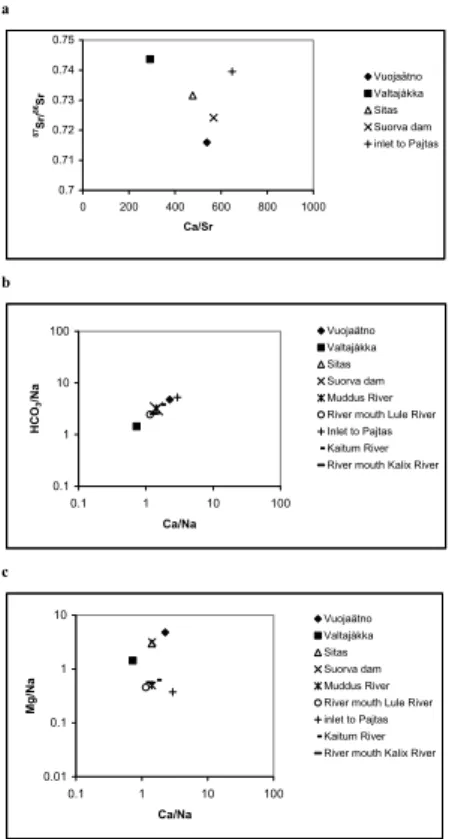
In the Na normalized mixing diagrams (Figs. 4b and c) the tributaries, Akkajaure reservoir and River mouth is plotted. The used end members ratios for carbonates in this study are estimated using data on small rivers draining one single lithology (carbon-ates, silicates and evaporites). These end member ratios are taken from Gaillardet et al. (1997); the silicate end member ratio for Ca/Na is 0.35 ±0.25, Mg/Na = 0.24±0.16,
20
Sr/Na = 3±1×10⁻³
, HCO3/Na = 1±1 and87Sr/86Sr = 0.73±0.01. The used end mem-ber ratios for carbonates in this study are Ca/Na = 45±25, Mg/Na = 15±10, Sr/Na = 40±20×10−3, HCO3/Na = 90±40 and 87Sr/86Sr = 0.7075±0.0005, and the evaporite end member ratios are Ca/Na = 0.17±0.09, Mg/Na = 0.02±0.01, Sr/Na = 3±2×10⁻³
, HCO3/Na = 0.3±0.3and87Sr/86Sr = 0.7081±0.0005.
25
The Sr isotope ratio plotted vs. the molar Ca/Sr ratio in Fig. 4a demonstrates the mixing in Vuojat ¨atno between old silicate rock, with87Sr/86Sr ratios>0.73 and carbon-ates (limestone), with87Sr/86Sr ratios around 0.709, also the present value in oceans (Dickin, 1997). Valtaj ˚akka is draining the old granitic Precambrian basement resulting
HESSD
4, 555–588, 2007
Weathering rates and origin of inorganic carbon J. Brink et al. Title Page Abstract Introduction Conclusions References Tables Figures ◭ ◮ ◭ ◮ Back Close
Full Screen / Esc
Printer-friendly Version Interactive Discussion
EGU
in higher Sr isotope ratios>0.74 (Faure, 1986). Vuojat ¨atno also shows very homoge-nous Sr-isotope ratios over the year, which is probably due to an increasing weather-ing intensity of isotopic homogenous bedrock and soil layers with increasweather-ing discharge but is also influenced by two major lakes upstream of the outlet of Voujat ¨atno in the Akkajaure reservoir, Virihaure (4.4 km3) and Vastenjaure (3.0 km3). In Valtaj ˚akka the
5
Sr isotope ratios varies with discharge, although the variation is small. The highest Sr isotope ratio is observed during winter, possibly showing a combination of deeper groundwater percolation near the old Precambrian basement, with higher Sr-isotope values and small dilution effects of the bedrock strontium signal due to low rain water discharge during winter.
10
In Table 6 the element mass budgets, weathering rates and the consumed CO2 for the investigated different sources are presented, i.e. carbonates, silicates, evap-orites and rain, and atmosphere, silicate and carbonate, respectively. The silicate weathering rate is specified as a flux (mass budget/total drainage basin) and spe-cific fluxes (mass budget/silicate outcrop in the drainage basin) and the spespe-cific
15
weathering of lowland areas (total river load-headwater load)/(total catchment area-headwater area). The different flux estimates show that cations released from weath-ering of silicates and the amount of carbon dioxide used for silicate weathweath-ering dom-inates unregulated lowland rivers such as Muddus River (unregulated tributary to Lule River) and the river mouth of Kalix and Kaitum Rivers in the headwater of
20
Kalix River. The silicate weathering rates for these rivers showed almost the same value; 45.1×10³mol km−2yr−1 for Muddus River, 46.7×10³mol km−2yr−1 for Killingi and 47.4×10³mol km−2
yr−1
for the river mouth of Kalix River. At the river mouth of Lule River this value is 27.7×10³mol km−2yr−1. In the headwaters of Lule River these numbers are, Valtaj ˚akka 27.9×10³mol km−2yr−1, Vuojat ¨atno 24.7×10³mol km−2yr−1,
25
Akkajaure 26.0×10³mol km−2
yr−1
and Sitas 16.4×10³mol km−2
yr−1
showing the slowest silicate weathering rate (Table 6,Fcationicsil). To get a more “true” value for the silicate weathering rate, it is possible to relate the rate to the specific outcrop of silicate rock in the drainage area. Here presented asFcationic sil specific outcrop (mol/specific
HESSD
4, 555–588, 2007
Weathering rates and origin of inorganic carbon J. Brink et al. Title Page Abstract Introduction Conclusions References Tables Figures ◭ ◮ ◭ ◮ Back Close
Full Screen / Esc
Printer-friendly Version Interactive Discussion
EGU
outcrop of silicate rock in km2/year). The calculated specific cationic silicate denuda-tion rates,Fcationicsil specific outcrop, for Vuojat ¨atno, Valtaj ˚akka, Lule River mouth, and Sitas are; 38.0×, 35.4×, 32.1×, and 22.9×10³mol km−2
yr−1
, respectively.
5 Discussion
On a large scale many variables control the chemical denudation of continents, such
5
as lithology, runoff, temperature, relief and vegetation. The importance of bedrock on chemical denudation rates was identified early (Garrels and Mackenzie, 1971; Mey-beck, 1987). Studies have shown that the silicate chemical weathering rates are 2 to 3 times higher for silicate rocks in the Andean mountain basins compared to the lowland basins (Gaillardet et al., 1997). The largest difference of almost a factor 40 is shown for
10
the River Solimoes, draining the Andes, compared to the Rio Negro (Guayana shield, highly weathered Precambrian shield) in the lowland. In another study on the 60 largest rivers of the world, Gaillardet et al. (1999) concluded that the possible controlling vari-ables for modern silicate weathering rates is a combined effect of runoff-temperature and physical denudation. These parameters which are related to both climate (e.g.,
15
temperature, precipitation, and runoff) and tectonics (e.g., physical denudation, sedi-ment transport, landscape surface age, and bedrock exhumation) are the main prin-cipal factors controlling physical and chemical weathering over geological time scale (i.e. transport-limited or weathering-limited regime). Recent studies have also shown the importance of DOC/TOC (Humborg et al., 2004; Millot et al., 2003) for Si
concen-20
tration in rivers and thereby silicate weathering rates.
Our detailed analyses on weathering rates in boreal and sub arctic systems shows that although much higher specific discharge and steeper slope angel, i.e. higher phys-ical erosion, the weathering rates are less in a regulated river compared to an unreg-ulated river, i.e., lower concentrations of dissolved solids can not only be explained by
25
a dilution effect; there is indeed less weathering occurring. Moreover, weathering rates are higher in the lowlands compared to the headwaters in both systems. This suggest
HESSD
4, 555–588, 2007
Weathering rates and origin of inorganic carbon J. Brink et al. Title Page Abstract Introduction Conclusions References Tables Figures ◭ ◮ ◭ ◮ Back Close
Full Screen / Esc
Printer-friendly Version Interactive Discussion
EGU
that in this cold and weathering limited system the role of vegetation and soil thick-ness is much more evident for weathering rates than in warmer and wetter climates elsewhere. However, about 5% of the total land cover within the watershed of the Lule River has been converted into water area (reservoirs) and this occurred especially along the river valleys of the headwaters where alluvial sediment was continuously
5
deposited leading to a formerly riparian zone with a rich vegetation cover. The effect of this % change in land cover is therefore much higher than what is revealed with number on how much land is converted into water area. Although we can not quan-tify yet the role of these alluvial deposits for overall weathering rates we hypothesize here that the drowning of these areas that came along with river regulation explain to
10
a significant extent the lower weathering rates observed in the Lule River compared to the Kalix River. The effect from much smaller water level fluctuations in the river valley not affected by damming should also be considered as an important factor (reduced water/soil interactions in the riparian zone).
5.1 Weathering sources, major dissolved components, TOC and end member mixing
15
The silicate dominated Precambrian basement in the lowland of the Kalix and Lule River shifts the river mouths chemistry more toward the Si corner in the ternary di-agram (Fig. 3), compared to the more carbonate dominated headwaters (especially Vuojat ¨atno and Sitas which represent catchments with large lakes). This silicate weath-ering signal is also observed in the mixing diagram for Muddus River, Kaitum River
20
(Killingi) and Valtaj ˚akka (Fig. 4), where the sodium normalized values are lower than the tributaries to the Akka system with carbonate weathering dominance.
In the pristine catchment Kalix River, and in the unregulated Valtaj ˚akka and Muddus River in Lule River Basin, the major element concentrations vary seasonally (Table 5). Vuojat ¨atno, Sitas and the river mouth of Lule River show very small dilution effects
25
(i.e. melt water diluting the ground water signal), which probably can be attributed to the lithology in Vuojat ¨atno (and large lakes upstream) and regulation effects for Sitas and Lule River (large reservoirs). The seasonality, with spring peak discharge and
HESSD
4, 555–588, 2007
Weathering rates and origin of inorganic carbon J. Brink et al. Title Page Abstract Introduction Conclusions References Tables Figures ◭ ◮ ◭ ◮ Back Close
Full Screen / Esc
Printer-friendly Version Interactive Discussion
EGU
low winter base flow is flattened out on yearly basis compared to the Kalix River, as well as the differences in concentration of major element. Vuojat ¨atno is dominated by carbonate rock weathering (see Figs. 3 and 4), which under high discharge may lead to an increase in weathering (Berner and Berner, 1996). The same effect may also be important for the weathering of silicates, when fresh silicate mineral surfaces are
5
exposed to the increasing physical erosion caused by high runoff (but only to a certain degree where dilution may become important again).
This inverse relationship between Ca2+ and Na+, is unusual in fresh waters, and may be a result of dominating rainwater contribution to stream water (sea salt), halite dissolution, silicate dominating weathering (Na-plagioclase) over Calcite, or biomass
10
uptake of Ca2+. In small river catchments it can be difficult to quantify the mean annual concentrations when studies have been done with only a few samples. Short-term climatic and biotic fluctuations can be omitted or in some cases dominate the data, principally due to the role of flood events in small watersheds. Salt and nutrients are stored in the unsaturated zones and washed out during events of high discharge
(Dr-15
ever, 1997). Each flood influences significantly the annual mass balance of elements and discharge and can be hard to capture in small watersheds with a fast response to rainfall/snowmelt and thereby showing large fluctuations in runoff during the year.
In Vuojat ¨atno where carbonate sedimentary rocks are present, the Ca2+ concentra-tion exceeds 100µmol L−1
and alkalinity (as HCO−
3) reaches values around 200µeq
20
L−1
. The highest dissolved Si concentration in the headwater of Lule River was ob-served in Valtaj ˚akka as shown by Humborg et al. (2004) to be caused by vegetated soil (in Valtaj ˚akka the land cover consists of 1.13% coniferous forest, mainly spruce and 13.62% deciduous forest, mainly birch), and it is very likely that vegetation plays an important role for weathering of silicates (Moulton and Berner, 1998; Moulton et
25
al., 2000), especially in a weathering rate limited environment (Anderson et al., 2000; Drever, 1994; Drever and Zobrist, 1992; Millot et al., 2002). Jacobson et al. (2003) stress the importance of geomorphic control on silicate weathering in the Southern Alps, New Zealand, which support our result of silicate weathering rates (Table 7) from
HESSD
4, 555–588, 2007
Weathering rates and origin of inorganic carbon J. Brink et al. Title Page Abstract Introduction Conclusions References Tables Figures ◭ ◮ ◭ ◮ Back Close
Full Screen / Esc
Printer-friendly Version Interactive Discussion
EGU
the headwater of Lule and Kalix River. In these weathering limited regimes, with steep topography, rapid discharges (short mean residence times for water), and small veg-etated flood plains, water-rock interaction times are limited. Under these conditions, chemical weathering is selective and favours highly soluble minerals with rapid disso-lution rates like calcite instead of silicate minerals. The low silicate weathering rates
5
in the uppermost part of the headwater of Kalix River and Lule River, can therefore be explained by this geomorphic/water-rock interaction theory.
5.2 Weathering rates
The calculated weathering rates for the investigated rivers show higher rates for the Kalix River system compared to the Lule River system (Table 6).
Further-10
more, the silicate weathering rate is the highest in the lowland part, with rates of 48×103mol km−2
yr−1
and 45×103mol km−2
yr−1
, in the Kalix and Lule River respec-tively. In the headwaters these numbers are 47×103mol km−2
yr−1
calculated for Killingi in the Kalix River basin and 38×103mol km−2yr−1calculated for Vuojat ¨atno, in the Lule River Basin. This difference in rates suggests that silicate weathering in sub-arctic
bo-15
real climates is controlled by the residence time for water rock interactions followed by lithology. Dam constructions have shown to be a sink for nutrients, due to the increase of water residence time, which produces the pre condition for photosynthesis and algal growth in the reservoirs (Humborg et al., 2000, 1997). Previous studies have, however, concluded that biological uptake of dissolved Si by diatoms is not significant in the Lule
20
River basin and it can therefore be ruled out that this is a major sink for Si (Humborg et al., 2004).
In the headwater, were we have steep topography and higher runoff like in Vuo-jat ¨atno the lithology is of major importance, given the highest silicate weathering rate for Vuojat ¨atno, were we have more weatherable minerals compared to the other
head-25
water rivers at the same altitude and with similar runoff. Killingi in Kaitum river is draining an area in size comparable to Vuojat ¨atno’s with a similar landscape cover, i.e. glacier, barren land, unvegetated and vegetated soil, but is reaching to a lower
ele-HESSD
4, 555–588, 2007
Weathering rates and origin of inorganic carbon J. Brink et al. Title Page Abstract Introduction Conclusions References Tables Figures ◭ ◮ ◭ ◮ Back Close
Full Screen / Esc
Printer-friendly Version Interactive Discussion
EGU
vation (from about 400–2000 m a.s.l.) compared to Vuojat ¨atno, where more vegetated soils increase water rock interaction time, making the weathering less selective and optimizing weathering of silicates compared to highly soluble calcite.
This study and the study of the sub-arctic Mackenzie River basin by Millot et al. (2003), reports (in comparison with the global average river) low silicate
weath-5
ering rates. The silicate fluxes (as cationic silicate weathering rates) calculated for Lule River Basin and Kalix River Basin, range from 0.92 to 1.61 t km−2
yr−1
, respec-tively, and for Mackenzie River basin from 0.13 to 4.33 t km−2
yr−1
. Land and Ohlander (2000) have estimate the chemical weathering rates (as base cation flux) of granitic till in a small catchment (9.4 km2) in Kalix River Basin to 0.356–0.553 keq ha−1
yr−1
, which
10
is slightly lower than our estimation for Lule River and Kalix River basin of 0.415 and 0.727 keq ha−1yr−1, respectively.
The difference in weathering rates for Kalix and Lule River is most likely caused by the inundations of the river valleys in Lule River in order to regulate the water (build-ing dams and reservoirs) and generate electricity. The river valleys contain the alluvial
15
deposits and therefore even small changes in the landscape in these areas will have a significant impact on the soil/water contact and water residence time in the soil. This can be seen as a decrease of the active area of minerals exposed to chemical weath-ering resulting in lower weathweath-ering rates and concentrations of weathweath-ering products in the river.
20
5.3 CO2consumption (sequestration of C) and weathering rates
Globally about 64 % (or near 2/3) of the dissolved inorganic carbon (DIC, mainly as HCO−3) in natural waters is derived from the reaction between carbonic acid and miner-als (Berner and Berner, 1996; Meybeck, 1987). The production of HCO−3 is a result of the consumption/sequestration of atmospheric/soil CO2 during weathering of silicate
25
and carbonate rocks (Reactions 3–6). The relative distribution between silicate and carbonate rock origin of DIC varies, largely because of the much higher weathering rates for the dissolution of carbonate rocks. The contribution of silicate rock in DIC
HESSD
4, 555–588, 2007
Weathering rates and origin of inorganic carbon J. Brink et al. Title Page Abstract Introduction Conclusions References Tables Figures ◭ ◮ ◭ ◮ Back Close
Full Screen / Esc
Printer-friendly Version Interactive Discussion
EGU
is from the carbonate rich drainage areas of Sitas and Vuojat ¨atno 57% and 55%, re-spectively, and for the silicate dominated drainage areas of Valtaj ˚akka 63%, Muddus River 82%, river mouth of Lule River 68%, headwater of Kalix River 72% and at river mouth of Kalix River 74% (Table 6). The total alkalinity calculated from the stoichiome-try with the used model in this study overestimates the alkalinity with nearly 20 to 30%,
5
showing that other proton sources than carbonic acid may be important, i.e. for exam-ple pyrite weathering and DOC. The CO2consumption/sequestration estimated during weathering are in this study based on the assumption that the only proton source for rock weathering is carbonic acid.
The organic transport of carbon to the sea includes also most of the inorganic
car-10
bon since a large part of the inorganic carbon originates from degradation of organic matter, i.e. from soil respiration. For the Kalix River (1990–2000) the mean for TOC (expressed as C) was 4.9 mg L−1
and for Lule River (1990–2000) 2.4 mg L−1
(Nilsson, 2006). Taking the alkalinity value as approximately the bicarbonate concentration (and all inorganic carbon, this assumption will underestimate the inorganic carbon) the
inor-15
ganic C that originates from organic C is for the Kalix River 1.9 mg L−1
(from Table 5, 0.216×12×0.74) and for Lule River 1.2 mg L−1
(from Table 5, 0.149×12×0.68). This means that the organic carbon load for Kalix River is underestimated by 30% and for Lule River by almost 35%. This shows that if climate effects are investigated and only using TOC/DOC as a proxy for increased degradation of organic matter changes in
20
the total carbon load may occur but not necessarily detected in the TOC/DOC fraction (i.e. leads to more weathering and production of more DIC). The total carbon load, inorganic and organic, must therefore be considered if trends for carbon balances in boreal sub arctic watersheds are investigated. In conclusion not only dissolved solids as Si, Ca and Mg will decrease with regulation (Humborg et al., 2000, 1997), a
de-25
struction of soil layers due to damming or erosion will decrease alkalinity export fluxes and therefore also influence regional C budgets.
HESSD
4, 555–588, 2007
Weathering rates and origin of inorganic carbon J. Brink et al. Title Page Abstract Introduction Conclusions References Tables Figures ◭ ◮ ◭ ◮ Back Close
Full Screen / Esc
Printer-friendly Version Interactive Discussion
EGU
6 Conclusions
The difference in chemical weathering rates between lowland regions and headwa-ters suggests that silicate weathering in sub arctic boreal climates is controlled by the residence time for soil water rock interactions followed by lithology.
The calculated weathering rates for the investigated rivers show higher rates for the
5
Kalix River system compared to the Lule River system by 30%. The difference in weathering rates for Kalix and Lule River is most likely caused by the inundations of the river valleys in Lule River where the alluvial deposits are “drowned” in the reservoirs causing water to have shorter residence in soils/rocks (see above on the importance of residence time vs. lithology).
10
The contribution in DIC from weathering of silicate rocks (sequestration of C), i.e. sili-cate origin of DIC, varies from 55% in the carbonate rich basins to about 80% in basins with high silicate rock domination. At river mouth these numbers are; Lule River, 68% and Kalix River, 74%. The actual organic carbon load leaving these rivers is therefore higher, since the carbon in DIC generated by weathering of silicate rocks origins from
15
degradation of organic matter in soils. This means that the organic carbon load for Kalix River is underestimated by 30% and for Lule River by almost 35%. If climate effects are investigated and only using TOC/DOC as a proxy for increased degrada-tion of organic matter, changes in the total carbon load may occur, but not necessarily detected in the TOC/DOC fraction. The total carbon load, inorganic and organic, must
20
therefore be considered if trends for carbon balances in boreal sub arctic watersheds are investigated.
References
Almgren, T., Dyrssen, D., and Fonselius, S.: Determination of alkalinity and total carbonate, in: Methods of Seawater Analysis, edited by: Grasshof, K., Erhardt, M. and Kremling, K., Verlag
25
HESSD
4, 555–588, 2007
Weathering rates and origin of inorganic carbon J. Brink et al. Title Page Abstract Introduction Conclusions References Tables Figures ◭ ◮ ◭ ◮ Back Close
Full Screen / Esc
Printer-friendly Version Interactive Discussion
EGU
Amiotte-Suchet, P. and Probst, J. L.: Modelling of atmospheric CO2consumption by chemical
weathering of rocks: application to the Garonne, Congo and Amazon basins, Chem. Geol., 107, 205–210, 1993.
Amrhein, C. and Suarez, D. L.: The use of a surface complexation model to describe the kinet-ics of ligand-promoted dissolution of anorthite, Geochimica et Cosmichimica Acta, 52(12),
5
2785–2793, 1988.
Anderson, S. P., Drever, J. I., Frost, C. D., and Holden, P.: Chemical weathering in the foreland of a retreating glacier, Geochimica et Cosmochimica Acta, 64, 1173–1189, 2000.
Andreasson, P. G. and Gee, D. G.: Baltoscandia’s outer margin (the Seve Nappe Complex) in the Kabnekaise-Singis area of Norrbotten, Swedish Caledonides. GFF, 111, 378–381, 1989.
10
Bergstr ¨om, S. and Forsman, A.: Development of a conceptual deterministic rainfall-runoff model, Nordic Hydrology, 4, 147–170, 1973.
Berner, E. K. and Berner, R. A.: Global Environment: Water, Air, and Geochemical cycles, Prentice-Hall, 376 pp, 1996.
Berner, R. A., Lasaga, A. C., and Garrels, R. M.: The carbonate silicate geochemical cycle and
15
its effect on atmospheric carbon dioxide over the past 100 millions years, Am. J. Sci., 283, 641–683, 1983.
Bj ¨orklund, L.: The Middle and Lower Allochthons in the Akkajaure-Tysfjord area, northern Scan-dinavian Caledonides, in: The Caledonide Orogen–Scandinavia and Related Areas, edited by: Gee, D. G. and Sturt, B. A., John Wiley & Sons, 512–528, 1985.
20
Bluth, G. J. S. and Kump, L. R.: Lithological and climatological controls of river chemistry. Geochimica et Cosmochimica Acta, 58, 2341–2359, 1994.
Dickin, A. P.: Radiogenic isotope geology, Cambridge University Press, Cambridge, 1997. Drever, J. I.: The effect of land plants on weathering rates of silicate minerals, Geochimica et
Cosmochimica Acta, 58, 2325–2332, 1994.
25
Drever, J. I.: The Geochemistry of Natural Waters: Surface and Groundwater Environments, Prentice-Hall, Upper Saddle River, New Jersey, 436 pp, 1997.
Drever, J. I. and Clow, D. W.: Weathering rates in catchments, in: Chemical Weathering Rates of Silicate Minerals: Reviews in Mineralogy, edited by: Brantley, S. and White, A., Mineralog-ical Society of America, Washington, D.C., 463–483, 1995.
30
Drever, J. I. and Zobrist, J.: Chemical-weathering of silicate rocks as a function of elevation in the southern Swiss Alps, Geochimica et Cosmochimica Acta, 56, 3209–3216, 1992.
HESSD
4, 555–588, 2007
Weathering rates and origin of inorganic carbon J. Brink et al. Title Page Abstract Introduction Conclusions References Tables Figures ◭ ◮ ◭ ◮ Back Close
Full Screen / Esc
Printer-friendly Version Interactive Discussion
EGU
Gaillardet, J., Dupr ´e, B., All `egre, C. J., and N ´egrel, P.: Chemical and physical denudation in the Amazon River Basin, Chem. Geol., 142, 141–173, 1997.
Gaillardet, J., Dupre, B., Louvat, P., and Allegre, C. J.: Global silicate weathering and CO2 consumption rates deduced from the chemistry of large rivers, Chem. Geol., 159, 3–30, 1999.
5
Garrels, R. M. and Mackenzie, F. T.: Evolution of Sedimentary Rocks, W. W. Norton & Company, 397 pp, 1971.
Gee, D. G. and Zachrisson, E.: The Caledonides in Sweden. C769, Sveriges Geologiska Un-ders ¨okning, 1979.
Holland, H. D.: The Chemistry of the Atmosphere and Ocean. John Wiley & sons, 351 pp,
10
1978.
Humborg, C., Conley, D. J., Rahm, L., Wulff, F., Cociasu, A., and Ittekkot, V.: Silicon retention in river basins: Far-reaching effects on biogeochemistry and aquatic food webs in coastal marine environments, Ambio, 29(1), 45–50, 2000.
Humborg, C., Ittekkot, V., Cociasu, A., and VonBodungen, B.: Effect of Danube River dam on
15
Black Sea biogeochemistry and ecosystem structure, Nature, 386(6623), 385–388, 1997. Humborg, C., Smedberg, E., Blomqvist, S., et al.: Nutrient variations in boreal and subarctic
rivers: Landscape control of land-sea fluxes, Limnol. Oceanogr., 49(5), 1871–1883, 2004. Jacobson, A. D., Blum, J. D., Chamberlain, C. P., Craw, D., and Koons, P. O.: Climatic and
tectonic controls on chemical weathering in the New Zealand Southern Alps, Geochimica Et
20
Cosmochimica Acta, 67(1), 29–46, 2003.
Kulling, O.: The geology of the Caledonian rocks of the northern Norrbotten mountains. 19, Geological Survey of Sweden, Stockholm, Sweden, 1964.
Kulling, O.: The Swedish Caledonides, in: Scandinavian Caledonides, edited by: Strand, T. and Kulling, O., John Wiley & Sons Ltd, 147–285, 1972.
25
Kulling, O.: ¨Oversikt ¨over norra Norrbottenfj ¨allens kaledonberggrund, 19, Geological Survey of Sweden, Uppsala, Sweden, 1982.
Land, M. and Ohlander, B.: Chemical weathering rates, erosion rates and mobility of major and trace elements in a boreal granitic till, Aquatic Geochem., 6(4), 435–460, 2000.
Meybeck, M.: Global chemical weathering of surficial rocks estimated from river dissolved
30
loads, Am. J. Sci., 287, 401–428, 1987.
Millot, R., Gaillardet, J., Dupr ´e, B., and All `egre, C. J.: The global control of silicate weathering rates and coupling with physical erosion: new insights from rivers of the Canadian Shield,
HESSD
4, 555–588, 2007
Weathering rates and origin of inorganic carbon J. Brink et al. Title Page Abstract Introduction Conclusions References Tables Figures ◭ ◮ ◭ ◮ Back Close
Full Screen / Esc
Printer-friendly Version Interactive Discussion
EGU
Earth Planet. Sci. Lett., 196, 83–98, 2002.
Millot, R., Gaillardet, J., Dupr ´e, B., and All `egre, C. J.: Northern latitude chemical weather-ing rates: Clues from Mackenzie River Basin, Canada, Geochimica et Cosmochimica Acta, 67(7), 1305–1329, 2003.
Mortatti, J. and Probst, J. L.: Silicate rock weathering and atmospheric/soil CO2 uptake in
5
Amazon basin estimated from river water geochemistry: seasonal and spatial variations, Chem. Geol., 1997, 177–196, 2003.
Moulton, K. L. and Berner, R. A.: Quantification of the effect of plants on weathering: Studies in Iceland, Geology, 26(10), 895–898, 1998.
Moulton, K. L., West, J., and Berner, R. A.: Solute flux and mineral mass balance approaches
10
to the quantification of plant effects on silicate weathering, Am. J. Sci., 300, 539–570, 2000. Nilsson, J.: Hydrogeokemin i Kalix ¨alvens, R ˚ane ¨alvens och Lule ¨alvens avrinningsomr ˚aden,
Stockholm University, Stockholm, 52 pp, 2006.
Probst, J. L., Mortatti, J., and Tardy, Y.: Carbon river fluxes and global weathering CO2 con-sumption in the congo and Amazon river basin, Appl. Geochem., 9, 1–13, 1994.
15
Raymond, P. A. and Cole, J. J.: Increase in the Export of Alkalinity from North America’s Largest River Science, 301, 88–91, 2003.
Sahlberg, J.: Physical control of primary production in a sub-arctic reservoir, Link ¨oping Univer-sity, Link ¨oping, 2004.
White, A. F. and Blum, A. E.: Effects of climate on chemical weathering in watersheds,
20
HESSD
4, 555–588, 2007
Weathering rates and origin of inorganic carbon J. Brink et al. Title Page Abstract Introduction Conclusions References Tables Figures ◭ ◮ ◭ ◮ Back Close
Full Screen / Esc
Printer-friendly Version Interactive Discussion
EGU
Table 1.Hydrology for Lule River and Kalix River and headwater tributaries. The runoff ratio is
the ratio of average river runoff (per unit area) to average rainfall (per unit area). Lule River Kalix River
Headwater Lowland Headwater Lowland Valldaj ˚akka Vouja ¨atno Sitas Akkajaure reservoir Muddus ¨atno River mouth Inlet to Pajtas Killingi River mouth Catchment (km2) 147 2842 977 4651 452 25225 299 2346 23846 Mean precipitation (mm) 1290 1332 1067 1180 583 698 623 630 544 Men Temperature ( ˚ C) –2 –2 –2 –2 –1 1 –2 –1.5 1 Mean runoff (m3s−1) 5.4 109 40.0 154 5.7 447 4.8 38.1 296 Specific discharge (L m−2yr−1) 1160 1208 1292 1045 400 559 504 512 391 Runoff Volume (*1012L yr−1) 0.2 3.4 0.9 4.9 0.2 17.6 0.2 1.2 9.3
% water discharge to River mouth 1.1 21.5 5.9 30.4 1.0 100.0 1.6 12.9 100.0 % water discharge to Akka system 3.51 70.61 19.31
Runoff ratio 0.90 0.91 0.90 0.89 0.69 0.80 0.81 0.81 0.72 Lule River:
*Mean precipitation and runoff from the period; 1985 to 2003 for Muddus ¨atno and at river mouth.
*Mean precipitation and runoff from the period; 1998 to 2000 for the headwater area. Kalix River:
HESSD
4, 555–588, 2007
Weathering rates and origin of inorganic carbon J. Brink et al. Title Page Abstract Introduction Conclusions References Tables Figures ◭ ◮ ◭ ◮ Back Close
Full Screen / Esc
Printer-friendly Version Interactive Discussion
EGU
Table 2.Element concentration in rainwater.
River Location pH Conductivity SO2−4 Cl−
NO− 3 NH + 4 H+ Ca2+ Mg2+ Na+ K+ CB µS cm−1 µmol L−1 % Lule Headwater 5.08 10.43 7.39 29.93 3.39 6.51 7.35 1.87 2.98 25.07 2.13 2.69 Muddus ¨atno 4.69 12.34 13.02 5.15 12.61 12.20 21.95 2.40 1.10 4.82 2.98 5.56 River mouth 4.82 11.31 10.46 18.84 8.97 9.72 16.91 2.29 2.14 16.44 2.38 5.43 Kalix Headwater 4.92 8.01 7.42 9.50 4.32 5.71 13.40 1.27 1.10 8.08 1.00 6.92 River mouth 4.69 12.34 13.02 5.15 12.61 12.20 21.95 2.40 1.10 4.82 2.98 5.56 Lule River:
*The element concentrations in Headwater area are mean values from the EMEP station, Trustervatn in Norway, 1977–2003 (http://www.NILU.no), and the PMK stations Abisko and Ammarn ¨as in Sweden, 1983–2004 (http://www.IVL.se).
*The element concentrations in rainwater for Muddus ¨atno are mean values from the PMK sta-tions, P ˚alkem in G ¨allivare district, 1983-2004 (http://www.IVL.se).
*The element concentrations in rainwater for River mouth is a weigthted mean value from the PMK stations, P ˚alkem in G ¨allivare district and Reivo in Arvidsjaur district (IVL), and the con-centration in precipitation from headwater.
Kalix River:
*The element concentrations in Headwater area are mean values from the PMK station Abisko in Sweden, 1983–2004 (http://www.IVL.se).
*The element concentrations in rainwater for River mouth is mean value from the PMK station, P ˚alkem in G ¨allivare district, 1983–2004 (http://www.IVL.se).
HESSD
4, 555–588, 2007
Weathering rates and origin of inorganic carbon J. Brink et al. Title Page Abstract Introduction Conclusions References Tables Figures ◭ ◮ ◭ ◮ Back Close
Full Screen / Esc
Printer-friendly Version Interactive Discussion
EGU
Table 3. The areal percent of major bedrock types, and the specific silicate and carbonate outcrop in the investigated catchments.
River Location Carbonate Carbonate Shale Basic Gneiss Granite Quartzite Carbonates Silicates Silicate Carbonate rock rich shale Rock and acid outcrop outcrop
volcanic rock
% % % % % % % % % km2 km2 Lule Headwater Vuojat ¨atno 7.2 16.8 19.4 28.2 12.4 1.1 3.9 24.0 64.9 1843 683 Valldaj ˚akka 0.0 20.8 2.4 0.0 64.6 8.4 3.3 20.8 78.7 116 31 Sitas 2.0 9.1 24.9 2.0 7.9 21.8 15.1 11.1 71.7 701 108 Akkajaure reservoir 4.1 13.3 17.8 16.8 25.0 3.9 4.9 17.3 68.4 3180 806 Lowland Muddus ¨atno 0.0 0.0 0.6 21.9 0.0 77.5 0.0 0.0 77.5 450 0
River mouth 1.4 2.9 7.0 14.2 11.4 48.3 5.3 4.3 86.2 21749 1073 Kalix Headwater Inlet to Pajtas 0.0 0.0 0.0 37.9 39.7 14.8 7.6 0.0 100.0 299 0
Killingi – – – – – – – – –
HESSD
4, 555–588, 2007
Weathering rates and origin of inorganic carbon J. Brink et al. Title Page Abstract Introduction Conclusions References Tables Figures ◭ ◮ ◭ ◮ Back Close
Full Screen / Esc
Printer-friendly Version Interactive Discussion
EGU
Table 4.Chemical analyses for Lule River and Kalix River and headwater tributaries. CB refers to the ionic charge balance.
River Location Date Season pH Cond Alk SO2−
4 Cl −
NO3+NO2 NH+4 Ca
2+ Mg2+ Na+ K+ Si Sr2+ TOC 87Sr/86Sr CB
µS cm−1 µeqv L−1 µmol L−1 ppm %
Lule Headwater Akkajaure reservoir 2000 06 14 Spring 6.7 21.2 164.4 22.7 54.9 2.4 0.1 66.4 23.6 45.8 11.0 14.4 0.1 0.5 0.7251 –6.05
2000 09 08 Summer 6.8 19.7 134.0 20.7 53.9 1.2 0.3 64.7 23.7 45.6 10.3 14.1 0.1 0.7 0.7233 0.52
2001 04 02 Winter 6.8 23.4 151.8 25.0 66.0 2.5 0.5 73.2 26.5 51.1 12.1 17.2 0.1 0.6 0.7239 –1.38
Mean 6.8 21.4 150.1 22.8 58.3 2.1 0.3 68.1 24.6 47.5 11.1 15.3 0.1 0.6 0.7241 –2.36
15.3
Voujat ¨atno 2000 06 14 Spring 7.0 27.8 226.0 23.5 63.8 2.3 0.1 98.2 35.4 45.1 7.2 12.7 0.2 0.4 0.7155 –2.97
2000 09 08 Summer 6.3 28.1 216.0 29.9 58.4 1.6 0.0 107.5 34.0 47.4 8.3 12.5 0.2 0.5 0.7165 0.44
2001 04 02 Winter 6.7 35.1 227.6 28.8 69.9 3.7 0.3 111.3 37.8 47.8 12.2 15.1 0.2 0.4 0.7159 –0.03
Mean 6.6 30.3 223.2 27.4 64.0 2.5 0.1 105.7 35.8 46.8 9.2 13.4 0.2 0.4 0.7160 –0.82
Valldaj ˚akka 2000 06 14 Spring 6.7 11.3 52.1 10.6 48.7 1.0 0.1 21.6 13.8 43.6 5.5 11.8 0.0 0.7 0.7402 –1.36
2000 09 08 Summer 6.2 10.4 48.3 14.1 47.1 0.0 0.0 30.0 15.8 39.4 5.8 17.0 0.0 1.4 0.7441 5.16 2001 04 02 Winter 7.0 23.5 120.6 24.6 71.7 3.6 0.2 60.5 26.7 70.7 28.7 70.7 0.1 0.5 0.7467 5.58 Mean 6.7 15.1 73.7 16.4 55.8 1.6 0.1 37.4 18.8 51.2 13.3 33.2 0.1 0.9 0.7437 3.83 Sitas 2000 06 14 Spring 6.5 19.0 138.7 23.2 55.2 2.5 0.2 59.8 20.2 44.1 11.8 13.5 0.1 0.5 0.7314 –5.84 2000 09 08 Summer 7.1 17.1 107.5 23.5 46.5 1.5 0.0 58.0 17.3 39.2 10.9 11.7 0.1 0.4 0.7316 –0.43 Mean 6.8 18.1 123.1 23.3 50.8 2.0 0.1 58.9 18.7 41.6 11.4 12.6 0.1 0.5 0.7315 –3.1
Lowland Muddus ¨atno 1985–2003 7.0 201.1 19.5 20.5 3.5 1.8 87.9 30.8 61.9 11.6 113.9 5.5
River mouth 1985–2003 6.9 29.3 149.2 22.1 48.0 2.1 1.1 70.6 27.9 61.3 11.2 40.1 2.8 5.28
Kalix Headwater inlet to Pajtas 1999 04 25 Winter 30.0 2.0 0.2 81.3 9.9 27.0 38.8 92.9 0.1
1999 12 08 Winter 31.3 136.6 41.5 19.6 3.2 0.3 69.2 8.2 22.7 37.0 93.4 0.1 –6.12 2000 05 08 Winter 52.1 31.6 1.2 0.2 69.7 11.8 27.2 29.4 90.1 0.1 2000 08 18 Summer 6.9 11.0 88.4 20.1 15.1 0.2 0.1 43.9 4.1 13.3 17.5 42.9 0.1 0.9 0.74229 –6.28 2001 04 04 Winter 6.3 23.3 146.0 42.0 19.1 5.8 0.2 81.8 9.6 27.3 35.5 110.9 0.1 0.5 0.752553 –1.87 Mean 6.6 23.9 123.7 38.9 21.3 2.5 0.2 69.2 8.7 23.5 31.6 86.0 0.1 0.7 0.74742 –3.30 Killingi 1985–2003 6.8 223.9 37.6 14.6 3.3 1.6 102.7 36.7 59.0 12.6 78.6 2.1 5.02
Lowland River mouth 1985–2003 6.8 216.1 51.1 45.9 6.9 2.5 112.1 47.5 84.9 16.6 100.3 5.1 6.27
*The concentrations are not corrected for atmospheric inputs (see Table 2 for mean rainwater concentrations)