Open Archive TOULOUSE Archive Ouverte (OATAO)
OATAO is an open access repository that collects the work of Toulouse researchers and
makes it freely available over the web where possible.
This is an author-deposited version published in :
http://oatao.univ-toulouse.fr/
Eprints ID : 15192
The contribution was presented at iEMSs 2014 :
http://www.iemss.org/sites/iemss2014/
To cite this version :
Thérond, Olivier and Sibertin-Blanc, Christophe and Lardy,
Romain and Gaudou, Benoit and Balestrat, Maud and Hong, Yi and Louail, Thomas
and Nguyen, Van Bai and Panzoli, David and Sanchez-Perez, Jose-Miguel and
Sauvage, Sabine and Taillandier, Patrick and Vavasseur, Maroussia and Mazzega,
Pierre Integrated modelling of social-ecological systems: The MAELIA
high-resolution multi-agent platform to deal with water scarcity problems. (2014) In: 7th
International Environmental Modelling and Software Society (iEMSs 2014), 15 June
2014 - 19 June 2014 (San Diego, California, United States).
Any correspondence concerning this service should be sent to the repository
administrator:
[email protected]
Integrated modelling of social-ecological systems:
The MAELIA high-resolution multi-agent platform to
deal with water scarcity problems
Olivier Therond1,*, Christophe Sibertin-Blanc2, Romain Lardy1,2, Benoit Gaudou2, Maud Balestrat1, Yi Hong3, Thomas Louail2, Van Bai Nguyen3, David Panzoli2, José-Miguel
Sanchez-Perez4, Sabine Sauvage4, Patrick Taillandier5, Maroussia Vavasseur1,2, Pierre Mazzega3 1
INRA, UMR 1248 AGIR, 31326 Castanet-Tolosan, France *[email protected]
2
Institut de Recherche en Informatique, UMR 5505, 31042 Toulouse, France
3
Geosciences Environnement Toulouse, UMR 5563, 31400 Toulouse, France
4
CNRS, UMR EcoLab, 31326 Castanet Tolosan Cedex, France
5
Université de Rouen, UMR IDEES, 76821 Mont Saint Aignan, France
Abstract: Sustainable water resource management is typical of environmental management
problems emerging from complex social-ecological systems. It deeply depends upon water user strategies, land use management and water governance systems. MAELIA, a “policy issue” modelling platform, allows performing integrated assessment at watershed level of a wide range of scenarios regarding water and land use management strategies in combination with global changes. It has been developed through a strong analysis of different French water management situations and an inductive modelling process. It allows representing dynamic interactions between human activities (farming practices), ecological processes (hydrology and crop growth), and governance systems (water regulations and releases from dams) at fine spatiotemporal resolutions in order to handle actual problems of water managers and issues of the main water users (farmers). MAELIA includes original farmer, dam manager and state services (software) agents.
Keywords: social-ecological systems, water management, integrated assessment and modelling,
agent-based model, farm model, decision process modelling
1. Introduction
Environmental and natural resource (NR) management problems are typically complex. They concern multiple actors with diverse and contrasting interests and objectives. They emerge into social-ecological systems (SES) in which four first-level core subsystems interact: two social-ecological ones (i) resource systems (e.g., water systems); (ii) resource units (e.g., water volume and river flow); and two social ones (iii) user systems (e.g., water users); and (iv) governance systems (e.g., organizations that manage water resources and seek to regulate water uses) (Ostrom, 2009). Interactions within and between these subsystems give rise to emergent structures and non-linear processes at sub and whole system levels.
During the last decades integrated assessment has been playing an increasing role to handle the environmental and resource management problems. Integrated Assessment and Modelling intends to combine several quantitative models of different multi-level system components into an integrated modelling platform. Such model-based approaches assemble data and knowledge from a wide range of scientific disciplines and put them into a “policy oriented context” in order to analyze the system responses to changes and to design sustainable management strategies. Many authors claim that the potential of model-based method is well-established for handling NR management and policy problems (Jakeman and Letcher, 2003). Oxley et al. (2004) distinguish two main types of models used in the Integrated Assessment and Modelling (IAM) approaches. The “research models” are process-oriented while the “policy-models” are practical policy issues-oriented.
Sustainable water resource management is typical for environmental management problems emerging from complex social-ecological systems. It deeply depends upon water users strategies,
Therond et al. / Integrated modelling of social-ecological systems: The MAELIA high-resolution multi-agent platform to deal with water scarcity problems
land use management and global environmental and societal changes (March et al., 2012). IAM approaches have been extensively applied to identify water and land management strategies allowing balancing socioeconomic (often agriculture) and water resource issues (Leenhardt et al., 2012). IAM aims at dealing with water quality or water quantity issues, through analysis of spatiotemporal interactions between land use and water resources within a watershed, require specific modelling approaches.
Regarding water quantity problems, many of the IAM approaches feature two main weaknesses. The first one is linked to the separate modelling before the coupling of socio-economic models and ecological ones. Indeed often in IAM platforms either simulation of the ecological models (e.g., crop or hydrological models) allows providing data that are used as inputs to the social ones (Ittersum et al., 2009) or socio-economic models (ex. Farmer behavior model) provide data about spatiotemporal distribution of human operations that are used as inputs to ecological models that simulate effects of these actions on the environment. Accordingly these models cannot represent dynamic interactions (i) between these two domain models at the relevant spatial and temporal scales (e.g., hydrology that daily determines possible water withdrawals) and (ii) interactions between different agents through their actions on NR (e.g., between up-stream irrigating farmers and down-stream ones through water). Secondly, IAM platforms often don’t represent the governance subsystem of the SES and so its interactions with “user” activities impacting NR (Ewert et al., 2009). For water quality, such a problem does not exist since regulations seeking to regulate users activities, generated by the “governance” subsystem, are defined for several years and are appropriately considered as exogenous factors and inputs of the socio-economic models. For dealing with water quantity issues it is a potential strong limitation. Particularly in water use regulated systems, where governance systems may establish local temporary regulations to limit water withdrawals in order to ensure the well-functioning of aquatic ecosystems. These temporary withdrawals regulations can significantly affect water user strategies and activities like irrigation and irrigated cropping system and in turn their efficiency and durability. The objective of this paper is to present the MAELIA modelling and simulation platform, a “policy issue” modelling platform developed to perform integrated assessment at watershed level of a wide range of scenarios regarding water and land use management strategies in combination with global changes. The strong originality of this IAM platform is to overcome both main modelling limitations discussed above. MAELIA is based on a multi-agent architecture that with its high-resolution allows simulating spatiotemporal interactions (including feedbacks) within and between the social and the ecological systems at the relevant scale for dealing with water management and associated agricultural issues. The expected typical end-users of outcomes of the MAELIA platform are policy-makers who deal with water scarcity problems in the different watersheds of the Adour-Garonne (river) Basin (AGB-South-West France); the main French river basin concerned by water scarcity problems. The second section of the paper presents the problem-finding modelling methodology that underpinned the MAELIA development process. The third section describes the way SES, corresponding to French water management situations, are modelled within the MAELIA platform. In the last section MAELIA calibration issues are discussed.
2. From stakeholder problems to the MAELIA IAM platforms
One of the great challenges when developing IAM platforms for sustainable development of SES is to ensure that information they provide will be useful for intended decision makers. An IAM platform is likely to be effective in influencing decision and in turn the evolution of the social system to the extent that it provides stakeholders with information that is perceived to be salient (relevant), credible (scientifically adequate) and legitimate (respectful of stakeholders’ divergent values and beliefs) (Cash et al., 2003). To reach this objective scientists need to ensure that the outcomes of their research are (i) context sensitive (i.e., sensitive to the spatial, temporal and complexity scales of the particular situation/problem under consideration) (McNie, 2007), (ii) take into account their points of view and interests of all stakeholders (Pahl-Wostl, 2005) and (iii) are based on systems thinking and complexity science allowing coping with interactions between subsystems to understand the whole system behavior (Bammer, 2005). Accordingly, to formulate the problem to be handled, i.e. the specification of the social-ecological system and question(s) at stake, it is necessary to analyze and formalize stakeholder representations and strategies. Knowledge engineering and mental representation elicitation methods allow understanding of perception, values, understanding, and
beliefs that underpin the decision-making process of stakeholders. They are well adapted for formalization of social aspects when developing decision support systems (Pahl-Wostl, 2005).
For developing the generic MAELIA platform we used this type of knowledge-driven and problem-finding modelling methods to inductively identify and model representations and strategies of key actors of the water scarcity management at watershed level. We first asked main institutions in charge of water management at the AGB level to collectively build a map of the water resource issues (also called “zoning based on stakeholders’ mental representations“) in the AGB. This map highlights the importance of different resources and related-problems. Using outcomes of this participatory exercise we identified 6 contrasted watersheds typical of the AGB in terms of social and ecological aspects regarding the water management. Then, for each watershed we performed (i) a “stakeholder analysis” to identify the key individual and organized or unorganized group of people who have an interest in the investigated issue and system and (ii) semi-directive individual interview of each key actor (about 35 to 45 per watershed). Interviews were organized to allow to create two types of knowledge-driven models.
First, cognitive maps of each stakeholder’s perception of the complex social-ecological systems in which he is involved were created. These cognitive maps represent interactions between actors and between actors and the biophysical environment through arrows labeled with action verb (see Mayor et al., 2012). Then the individual cognitive maps for each watershed were integrated into a synthetical one representing the “water management situation/problem” of the investigated watershed. Second, using outcomes of cognitive task analysis methods (Dury et al., 2012) implemented during interviews, we developed UML activity diagrams representing decision-making processes of the key actors. These diagrams indicate at which functional, spatial, and temporal levels and with which information and decision rules each actor makes decision and in fine act. Cognitive maps and UML activity diagrams were used as hypotheses to build a generic model of social-ecological systems through an inductive and iterative integration. They enabled us to identify entities and processes to take into account the spatial and temporal resolutions and level of functional complexity (e.g., farm) to be represented. In parallel to these analyses we also performed a specific analysis of the regulations of water management in the AGB. It enabled us to clearly identify the changes that may occur in the water management governance due to the implementation of the European Water Framework Directive and, very importantly, the needs of policy-makers for handling problems raised by this future governance change (see Debril and Therond, 2012, Mayor et al., 2012). Finally, to develop the conceptual model of the MAELIA platform from the wide range of knowledge described above we developed and used a meta-model of SES facilitating integration of knowledge into a formal conceptual model of the water management in the AGB (see detailed presentation in Sibertin et al., 2011).
3. The MAELIA IAM platform
The development process of MAELIA primarily consisted in clearly specifying the structure of the SES (entities and relations between them) and the ecological and socio-economic processes to represent. The main challenge of the MAELIA development was to model at the relevant levels dynamics of and interactions between:
- irrigated cropping and farming systems, respectively, at field and farm levels to represent respectively the diversity of production situations (combination of cropping systems-soil-climate-water resource) and of farm-level functioning constraints and economic results; - domestic and industrial water withdrawals at each withdrawal point;
- management for each dam in the investigated area to represent dynamics of water releases triggered to sustain water flow rate in rivers;
- water withdrawal regulation implementation at the French “reference sub-watershed” level and the day scale both corresponding to the decision levels of local State services in charge of protection of aquatic ecosystems;
- hydrology at the sub-watershed level and the day scale to be consistent with water withdrawals regulations;
- crop growth and yield at field level and day scale that determines respectively water demands and gross margin of cropping systems and so economic viability of farming systems.
Below and in the Figure 1 we sketch how processes are represented in MAELIA starting by ecological processes (the two last ones above) then human activities. Finally we present the way interactions between processes are managed in the platform.
Therond et al. / Integrated modelling of social-ecological systems: The MAELIA high-resolution multi-agent platform to deal with water scarcity problems
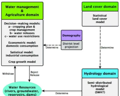
Figure 1. General representation of the MAELIA multi-agent modelling and simulation platform with the main domains and processes represented and types of implemented models.
3.1 Ecological processes
Many hydrologic and crop models exist. To represent these ecological processes we selected models (i) that can be applied on the wide range of hydrologic/production situations of the AGB, (ii) to be likely to provide realistic outputs and (iii) not too complicated in terms of number of equations and parameters to facilitate recoding and computing and limit “black-box” effect.
To represent hydrology at sub-watershed level we recode the formalisms of hydrologic cycles of the SWAT (Soil and Water Assessment Tool) model (http://swat.tamu.edu/). SWAT allows assessing impact of land cover and use changes on water resource states and agricultural yields. It is a semi-empirical model applied and used in numerous and various contrasted watersheds worldwide, with a great user community that exchange experiences and results. It is a semi-distributed model in which the hydrological balance is estimated and spatially allocated into so called “sub-watersheds” at a daily time step. These latter are subdivided into non-spatialized Hydrologic Response Units (HRUs) representing a unique combination of land cover, soil type and slope. HRU allow reflecting variability of evapotranspiration and runoff within each watershed. The possibility to define the size of sub-watersheds allows adapting the model to match requirements of the investigated hydrologic issues. In MAELIA we recoded equations of SWAT for both, (i) the land phase of the hydrologic cycle that controls the amount of water loadings to the main channel of each subwatersheds (snow cover and snowmelt, runoff with the curve number method, infiltration, redistribution in soil profile, evapotranspiration for non-crop plants, lateral subsurface flow and percolation into shallow and deep aquifer) and (ii) the routing phase of the hydrologic cycle that controls the movement of water through the channel network of the watershed to the outlet (transmission through the bed of the channel from shallow aquifer, evaporation and water routing through the channel with the Muskingum routing method). The sub-watershed and HRU delineation has been implemented thanks to a GIS approach based on French georeferenced databases on water resources, elevation, and land use. MAELIA sub-watersheds correspond to the finest grain of the French watershed classification called “reference sub-watershed” (area about 2 to 6 km2).
Modelling of plant growth differs according to the nature of plants. For non-crop plants (forest and grassland) we used a very simplified version of the corresponding modelling of SWAT. Given the question to handle with MAELIA, for these plants it is not necessary to simulate biomass production. For crops we selected a crop model simulating realistic crop yields in the various production situations of the ABG exempt of great and often-problematic calibration troubles. Hence, we recoded an empiric crop model developed by INRA (French national institute for agricultural research) in Toulouse (centre of the AGB). This model called “AquYield” (Murgue et al., this conference) has been developed step by step according to results of agronomic experiments in the AGB during the last 20 years. It seeks to represent phenomena rather than mechanisms to ensure simplicity and robustness and accordingly
large regional applicability. It simulates at a daily time step effects of climate, soil and cropping system on yield for the eleven main crops of the AGB. Regarding crop management, it represents effects of tillage (modification of soil layer depth that evaporates), sowing date (modification of the vegetation period) and irrigation on water soil dynamics. It simulates drainage and runoff and accordingly impacts shallow aquifer and water in rivers. It interacts with the land phase of the hydrologic module through this two water bodies.
3.2 Social processes
Two main types of social dynamics are represented in MAELIA: the socio-economic phenomena and human activities.
Socio-economic phenomena result from humans’ economic and social activities (i.e.,
socio-economic processes). Models of these phenomena consider only effects of socio-socio-economic processes, without representing how (the decision process) and by whom (agents) these effects are produced. They are generally represented through data series or statistical, probabilistic or econometric formalisms. Socio-economics processes represented in MAELIA concern land cover changes and domestic and industrial water withdrawals and rejections.
Land cover changes concern field plots disappearance in favor of forest or urban areas. The representation of these phenomena is based on an external data series that represents the field area that disappears each year per sub-watershed. It has been generated by analysis of the Corine Land Cover (CLC) database from 2000 and 2006. Plots that disappear each year are randomly chosen next to urban or forest area until their area exceed the predefined area.
Domestic water withdrawals are computed using the econometric equation developed in the MOGIRE model that accounts for the water price, principal residence rate, income, summer maximum temperature, and population density as parameters (Reynaud and Leenhardt, 2008). Dynamics of these population characteristics have been estimated through analysis of data provided by the French agency in charge of demography statistics and projections. Regarding discharges of (waste) water, three quarters of the yearly withdrawn volume for domestic use is considered as rejected. The daily withdrawn and discharged volumes in each withdrawn and discharge points are computed taking into account that daily withdrawn volumes are higher during summer. To compute the industrial water use and discharge, we use data (2010) from the dedicated database of the AGB water agency and consider that their volumes remain constant over years.
Human activities represented in MAELIA correspond to the ones that strongly and directly determine
daily water management during the low-water period. They represent activities of farmers, dam managers and local State services in charge of water use regulations. These actors are all represented in MAELIA by agents that use cognitive resources and have strategies to act according their own socio-economic and biophysical situations and objectives.
As in the AGB agricultural withdrawals represent about 80% of water consumptions during the low water period we developed a precise model of farmer activities that underpin these water withdrawals: the cropping plan decision and the crop management. The cropping plan decision module simulates allocation of cropping system (combination of rotation and crop management strategies) in each arable field of the farm. The choice of a rotation is carried out through a multi-criteria decision-making method based on Dempster-Shafer belief theory included in a Belief-Desire-Intention architecture (Taillandier et al., 2012). This multi-criteria method allows simulation of a decision made with incompleteness, uncertainly, and imprecision of knowledge. Accordingly, and very originally, it allows to represent the bounded rationality of humans (here farmers) leading to the choice of satisfying solutions while in most farm behavior models farmers are equipped with a “perfect rationality” i.e. fully informed, perfectly logical and leading to optimal (economic) solutions. We used outcomes of previous studies on the cropping plan decision process (Dury et al., 2012) to select four criteria used in the multi-criteria decision-making method: maximization of the profit, similarity to the last cropping plan, number of days without work and minimization of income variability.
Once each farmer agent allocated a cropping system in each farm’s field, it processes crop
management day after day in each field. Crop management strategies are represented through a set
of decision rules (nested IF THEN rules) to trigger tillage, sowing, fertilization, irrigation, and harvesting. These decision rules describe which soil, plant, or climate conditions are necessary to trigger each cultural operation and the temporal window during which it can be done. The daily spatiotemporal distribution of cultural operations over farm’s fields is determined according to the time necessary to perform each cultural operation and the spatial distribution and size of fields. In the same logic, the delivery of water to fields according to an irrigation turn delay (i.e., the number of days
Therond et al. / Integrated modelling of social-ecological systems: The MAELIA high-resolution multi-agent platform to deal with water scarcity problems
between each water delivery in a given field) is represented according to the annual area to irrigate and the size and position of irrigated fields (see Murgue et al., this conference). When water regulations are proclaimed the farmer agent adapts its irrigation strategy. Daily operations are limited by the farm’s available work resource. Moreover, if the sowing activity is not possible (e.g., because of important and recurrent rains), the farmer agent re-launches the cropping plan decision process to find an alternative cropping system for the fields where he cannot perform the initially chosen one. The crop management module is presented in detail in Murgue et al. (this conference). The farmer agent model uses many cognitive resources: possible cropping systems, input and production prices, passed weather and forecast, available water, regulations, etc. The French Land Parcel Identification System (a geographical database) has been used to represent the spatial distribution of fields of each French individual farm.
Strategies regarding water releases from dams and regulations of agricultural water withdrawals during the low-water period determine, day after day, to what extent water flow rates can be sustained and the agricultural needs can be satisfied (given that the domestic and industrial needs have priority). During low-water periods, flow rates of rivers are measured daily (as Average Daily Flow, ADF) at given pre-defined monitoring points. Regulatory thresholds are associated to these monitoring points. State services seek to regulate water uses and manage water releases to maintain water flow above these thresholds. In priority, when possible, they try to maintain water flow through water releases that they ask to dam managers. In MAELIA each dam manager agent seeks to optimize releases according to the State service demands and specific constraints of its dam(s): reserved flow (minimum water flow at the exit of the dam), maximum flow due to dam and river characteristics, period of release (e.g., due to touristic activities), transfer time between the dam and the targeted monitoring points, emptying curve of the reservoir that shows for each day the water volume to conserve in the dam to have a given probability (e.g., 2/3) to be able to release necessary water until the end of the low water period.
When it is not possible or sufficient to sustain water flow through water releases (no dams in the sub-watershed, no more available water in the dam) the State services might issue Drought Decrees that state withdrawal prohibition in some areas and for some days. Three levels of withdrawal restrictions can be launched when ADF passed 3 consecutive days under the regulatory thresholds affected to each monitoring points. These regulation levels correspond to one or several days with prohibition of agricultural withdrawals: 1 or 2 days a week (level 1), 3 or 4 days a week (level 2) or 7 days a week (i.e., permanent prohibition, level 3). Each drought decree concerns one or several pre-defined “drought zones”. Each zone is composed of several sub-watersheds determining water flow at a given monitoring point. To apply decrees of level 1 or 2 (prohibition some days a week), these drought zones are divided in (drought) sectors in which prohibition of agricultural water withdrawal moves from one or several sectors to another or others, day after day during the week. Additionally, the decision to apply this restriction is constrained by principles regarding progressivity of regulations (i.e., withdrawal restrictions must be progressive) and down- and up-stream solidarity (up-stream area of a given drought zone must be in a restriction level greater or equal). Modelling of dam and regulation management is presented in detail in Mayor et al. (2012).
3.3 Interactions between processes through entities
One of the main features of the MAELIA model is the fact that processes do not interact directly but only via entities. Equations and algorithms representing the different processes are not nested into general representation of the dynamics of the whole social-ecological system. At each day time step of a system run, the current state of entities (e.g., soil, river, plant, dam) determines the processes that are executed and their execution regime, in turn execution of these processes modifies some entity states. The best illustration corresponds to the interactions between processes impacting water resources at the watershed level. As presented above, the sub-watershed is the key entity of the hydrologic model. It is at this level that the water computed by the land phase is aggregated and then transferred from upstream to downstream sub-watershed through the routing phase. This water quantity computed at the sub-watershed level, is considered as a water reservoir in which various water users withdraw water for irrigation, domestic, or industrial uses. In addition, the sub-watershed is also the entity that deals with the plot field disappearance and the urban and forest sprawl (that will have an influence of the soil cover and thus runoff).
4. MAELIA implementation, calibration, and first applications
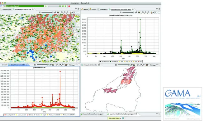
The MAELIA simulation model has been implemented with GAMA (http://code.google.com/p/gama-platform/); an open-source generic agent-based modeling and simulation platform with powerful features in terms of GIS integration or high-level tools (e.g., decision-making or clustering algorithms; Figure 2).
Due to the multiple levels and processes considered, the calibration and evaluation of the MAELIA multi-agent platform is a scientific challenge. Indeed, the most common calibration process (e.g., manual “trial-and-error”, local search algorithms, genetic algorithm) would be inefficient due especially to the interactions between formalisms, which have different forms (from classical differential equations to agent behavior algorithms). To get an overview of the model behavior and to identify influential parameters, multiple sensitivity analyses were performed, while considering some set of processes or the whole model. The calibration of influential parameters with a multi-objective (e.g., reproducing water flows and anthropic dynamics) and multi-criteria optimization problem was achieved thanks to meta-models built on an appropriated design of experiments. This calibration procedure is presented in detail in Lardy et al. (this conference).
Currently two applications of MAELIA have been implemented. They are presented in Murgue et al. (this conference) and Lardy et al. (this conference).
Figure 2. Screenshot of a simulation in progress under the MAELIA multi-agent modelling and simulation platform implemented with GAMA. It presents the position of farmers in their fields and the level of water withdrawal restriction (top-left), the daily water withdrawals (bottom left), the daily water flow in the river (top-right) and the area and level of water use restrictions (bottom-right) in the upstream part of the Garonne river basin (South-West France).
5. Conclusion
The MAELIA IAM platform deals with key challenges of modelling social-ecological systems. First, it represents dynamic interactions between human activities and ecological processes on the one hand and governance systems on the other. Second, it represents these interactions at the relevant spatiotemporal resolutions to handle actual problems of organizations in charge of water management and of issues of the main water users the farmers. MAELIA seems to have reached its objective to develop relevant knowledge for decision-makers since it is currently adapted to develop decision support systems for French local State services.
Therond et al. / Integrated modelling of social-ecological systems: The MAELIA high-resolution multi-agent platform to deal with water scarcity problems
6. Acknowledgement
The MAELIA Project “Multi-Agents for EnvironmentaL norm Impact Assessment” (http://maelia1.wordpress.com/) is funded by the French “Sciences & Technologies for Aeronautics and Space” Foundation (http://www.fondationstae.net/).
7. References
Bammer, G., 2005. Integration and Implementation Sciences: Building a New Specialization. Ecology and Society 10, 6.
Cash, D.W., Clark, W.C., Alcock, F. et al.., 2003. Knowledge systems for sustainable development. PNAS 100, 8086–91.
Debril, T. and Therond, O., 2012. Les difficultés associées à la gestion quantitative de l’eau et à la mise en oeuvre de la réforme des volumes prélevables : le cas du bassin Adour-Garonne. Agronomie, Environnement & Sociétés, 2, 127-138.
Dury, J., F. Garcia, A. Reynaud, O. Therond, Bergez, J.E., 2010. Modelling the Complexity of the Cropping Plan Decision-making. In Proceedings of the 2010 International Congress on Environmental Modelling and Software, Canada.
Ewert, F., van Ittersum, M.K., Bezlepkina, I., Therond, O. et al., 2009. A methodology for enhanced flexibility of integrated assessment in agriculture. Environmental Science and Policy, 12, 546-561. Jakeman, A.J., Letcher, R.A., 2003. Integrated assessment and modelling: features, principles and
examples for catchment management. Environmental Modelling & Software, 18, 491-501.
Lardy, R., Mazzega, P., Sibertin-Blanc, C., Auda, Y., Sanchez-Perez, J.S., Sauvage, S., Therond, O., 2014. Calibration of simulation platforms including highly interweaved processes: the MAELIA multi-agent platform. Daniel P. Ames, Nigel W.T. Quinn and Andrea E. Rizzoli (Eds.). 7th Int. Congress on Env. Modelling and Software (iEMSs), San Diego, CA, USA. http://www.iemss.org/society/index.php/iemss2014proceedings
Leenhardt, D., Therond, O., Cordier, M.O. et al., 2012. A generic framework for scenario exercises using models applied to water-resource management. Environmental Modelling & Software, 37, 125-133.
March, H., Therond, O., Leenhardt, D. 2012. Water futures: Reviewing water-scenario anal-yses through an original interpretative framework. Ecological Economics, 82, 126-137.
Mayor, E., Mazzega, P., Panzoli, D., Sibertin-Blanc, C., Therond, O., Vavasseur, M., 2012. Formal representation of Water Withdrawal Policies for Integrated Assessment. European Conference on Complex Systems 2012 (ECCS’2012), September 3-7, Bruxelles, Belgium.
McNie, E., 2007. Reconciling the supply of scientific information with user demands: an analysis of the problem and review of the literature. Environmental science & policy, 10, 17–38.
Murgue, C., Lardy, R., Vavasseur, V., Leenhardt, D., Therond, O., 2014. Fine spatio-temporal simulation of cropping and farming systems effects on irrigation withdrawal dynamics within a river basin. Daniel P. Ames, Nigel W.T. Quinn and Andrea E. Rizzoli (Eds.). 7th Int. Congress on Env. Modelling and Software (iEMSs), San Diego, CA, USA.
http://www.iemss.org/society/index.php/iemss2014proceedings
Ostrom, E., 2009. A general framework for analyzing sustainability of social-ecological systems. Science, 325, 419-422.
Pahl-Wostl, C., 2005. Actor based analysis and modelling approaches. Integrated Assessment 5, 97-118.
Reynaud, A. and Leenhardt, D., 2008. Mogire: A model for integrated water management. In Proceedings of the 20008 International Congress on Environmental Modelling and Software, Barcelona, Spain.
Sibertin-Blanc, C., Therond, O., Monteil, C., Mazzega, P; 2011. Formal Modeling of Social-Ecological Systems. 7th International Conference of the European Social Simulation Association (ESSA 2011), September 19-23, Montpellier, France.
Taillandier, P., Therond, O., Gaudou, B., 2012. A new BDI agent architecture based on the belief theory. Application to the modelling of cropping plan decision-making. In Proceedings of the 2008 International Congress on Environmental Modelling and Software, Leipzig, Germany, pages 1–5, 2012.
Van Ittersum, M., Ewert, F., Heckelei, et al., 2008. Integrated assessment of agricultural systems—a component-based framework for the European Union (SEAMLESS). Agricultural Systems, 96, 150–165.