Acknowledgements
The authors would like to thank the sponsoring convention societies for the opportunity to conduct this field trip. In addition, GUPCO has provided outstanding logistical support for pre-trips, drafting, security and expertise. Apache Egypt Companies has directly funded this field trip and is sponsoring publication of the field guide, as well as vehicles used on the trip. BP-Egypt has been instrumental in requiring safe driving certification by all drivers and additional desert driving training classes.
Much of the background of this guidebook has built upon the work of Hassouba et al. (1988). This pioneering work of subsurface and outcrop data integration has formed the basic framework for renewed study of the Bahariya outcrops.
The authors also thank Debbie Dolson for her efforts to edit and proof this guidebook.
Figure 1 Members from all societies have the chance to visit the Valley of the Golden Mummies at Bahariya Oasis, the largest discovery of mummies in the world.
Table of Contents:
Acknowledgements ...2
Introduction ...6
Prior Work...6
Regional Setting ...6
Early Genesis of Western Desert Petroleum Systems...8
Basins of the Western Desert ...9
Stratigraphic Nomenclature ...11
Regional Controls on Northward Transport of Sediment ...12
Syrian Arc Event...13
Bahariya Oasis: Geological Framework...14
Structural Setting of the Western Desert and Bahariya Oasis...15
Tectonic History of Bahariya Oasis ...20
Stop No. 1 ...22
Stop No. 2 ...29
Stop No. 3 ...31
Stop No. 4 ...31
Stop No. 5 Gebel Mendisha ...31
Stop No. 6 Gebal El Dist ...31
Unit 1-- Rippled sandstone and shale (tidal flat/bay deposits?)...31
Unit 2-- Shale with thin rippled sandstone layers (swamp environment) ...32
Unit 3-- Cross bedded sandstone with erosional base (fluvial channel) ...36
Unit 4-- Shale with basal sandstone beds (tidal flat and transgressive central basin mud)...38
Unit 5-- Shale, siltstone and sandstone with basal lag (brackish to restricted marine) ...39
Stop No 7--Gabel El Magrapha ...40
Unit 1-- Shale with thin rippled sandstone layers (swamp environment) ...40
Unit 2-- Shale beds with basal transgressive fossil lags and cross stratified sandstone (bay fill and tidal flat?)...43
Unit 3-- Cross-stratified sandstone with erosive base and fossil lag (tidal channel) ...43
Unit 4-- Shale with thin sandstone beds (tidal flat and tranrgressive central basin mud) ...44
Unit 5-- Shale, sandstone and siltstone with basal lag (brackish to restricted marine) ...44
Stop 8 (Naqb El Selem) ...44
Depositional Environment and Sequence Stratigraphy ...46
Incised valley fill model...46
Stop 9 (Gabal El Calcite) ...48
Subsurface study of the Bahariya and Kharita formations—Abu Gharadig and Rezzak fields ...50
Kharita Formation--Abu Gharadig and Rezzak fields ...54
Reservoir properties—Abu Gharadig Field ...55
Sea level fluctuation during Upper Cretaceous time ...59
Archaeology of and other items of interest in the Bahariya Oasis ...60
Table 2. Web links to information on dinosaurs and the Valley of the Golden Mummies in Bahariya Oasis ...60
Bahariya Oasis ...60
Valley of the Golden Mummies...63
List of Figures
Figure 1 Members from all societies have the chance to visit the Valley of the Golden Mummies at Bahariya Oasis,
the largest discovery of mummies in the world. ...2
Figure 2 Landsat imagery of Northern Egypt. Purple dots are well control in the Western Desert, Nile Delta and North Sinai. Green polygons are oil and gas fields in the Western Desert. Red polygons are gas fields of the Nile Delta. See Figure 3 for the regional cross-section from Bahariya Oasis to the Nile Delta. ...7
Figure 3 Regional cross-section (not scaled) from Bahariya Oasis to the Nile Delta. ...8
Figure 4 Three-dimensional view of basement across Northern Egypt. Modified from (Loutit et al., 2001)...9
Figure 5 Basins and fields of the Western Desert ...10
Figure 6 Western Desert generalized stratigraphic column...11
Figure 7 Regional tectonic setting at early Cretaceous time (SRK Consulting, 2000). ...12
Figure 8 Late Cretaceous through Eocene structural setting during the transpressional Syrian Arc event (from SRK Consulting, 2000). This event inverted many of the Western Desert basins and effectively ended petroleum migration and generation in many areas by early Oligocene time...13
Figure 9 Geological map of Egypt showing the outcrops of the Western Desert and major stops. ...14
Figure 10 Schematic cross-section of features traversed from Cairo to Bahariya Oasis...15
Figure 11 Geological map showing formations and major fault and fold trends in the Bahariya Oasis. Modified after Ball and Beadnell (1903). ...18
Figure 12 Formations outcropping at Bahariya Oasis. ...19
Figure 13. Landsat imagery of the oasis...20
Figure 14 A typical seismic line (time) from Rezzak Field illustrating major tectono-stratigraphic events in the Western Desert. ...21
Figure 15 NW/SE 3D seismic profile over Qarun Field and the northeast flank of North Qarun Field. Both fields are Syrian Arc compressional fold structures that produce from Bahariya and Kharita sandstone reservoirs (illustration courtesy of Apache Corporation, Ocean Energy and Qarun Petroleum Co.)...22
Figure 16 Depositional model of Lower Bahariya at Qarun Field (Farris, 2001). ...23
Figure 17 Modern depositional model of Qarun Field Bahariya and Kharita formations (Harris, 2001). ...24
Figure 18 Lower Bahariya stratigraphic cross section through Qarun Field, illustrating internal stratigraphic complexity and stacked amalgamated channel facies (Harris, 2001). ...25
Figure 19 A schematic representation of the Qarun Field. Seismic lines indicated are shown in figures 20 and 21...26
Figure 20 Dip profile through Al Ahram Field Structure. The Cretaceous section exhibits thickening updip toward the inverted structural feature, formerly a paleo-low. See Figure 18 for location...27
Figure 21 Dip profile across the central portion of the Qarun-WD19 structural ridge. See Figure 18 for location...28
Figure 22 Late Eocene paleogeography (modified from (Dolson et al., 2002 (in press)). The regional geological sections indicated are not included in this guidebook. The drainage networks shown were well developed by Oligocene time, when the ancestral Nile Delta probably lay west of its present position, flowing down the axis of the Abu Gharadig Basin...29
Figure 23 Columnar basalt sheet (dark-collared unit capping the ridge) covering the top of the Bahariya Formation. .31 Figure 24 General view of Gebel El Dist showing different lithofacies. This outcrop section is 106 meters (350feet) thick. ...32
Figure 25 Stratigraphic section at Gebel El Dist, section 1. Thickness units are in feet. ...33
Figure 26 Gebel El Dist, section 2. Thickness units are in feet...34
Figure 27 Iron-stained roots within unit 2, Gebel El Dist. A) rootlets B) iron concretion layers ...35
Figure 28 The east facing side of Gebel El Dist showing erosional contact (unconformity surface) between the fluvial sandstone (the area between solid lines) and the underlying swampy facies (reddish brown color)...35
Figure 29 Large-scale cross bedding at the basal part of the fluvial channel...36
Figure 30 Large-scale tabular cross bedding overlying the trough cross bedding. ...37
Figure 31 Convolute bedding at the top of the point bar...37
Figure 32 Climbing ripples at the top-most part of the point bar. ...37
Figure 33 Block diagram showing depositional environments of the fluvial channels filling the lower part of the incised valley at Stop 6. ...38
Figure 34 Transgressive surface of wavy bedded conglomeratic sandstone, Unit 4...39
Figure 35 Faintly laminated sandstone with cryptic bioturbation. ...39
Figure 36 Well-developed unconformity surface with basal lag deposits Glossifungites ichnofacies...40
Figure 37 Coarsening upward cycles of laminated siltstone and mudstone...40
Figure 38 General view of Gabel El Magrapha. The section is 106 meters (350 feet) thick. ...41
Figure 39 Stratigraphic section at Gebel El Maghrafa. Thickness units are in feet. ...42
Figure 40 Glossifungites surface characterized by Thalassinoids traces filled with coarse debris from overlying strata. ...43
Figure 41 Cross-bedded sandstone with elongated mud drapes...43
Figure 42 Cross-bedded tidal channel sandstone with basal erosional contact and oyster shell lags...44
Figure 43 Channel fill sandstone with erosional surface cut into laminated sandstone and mudstone...45
Figure 44 Cross-bedded sandstone with elongated mud drapes...45
Figure 45 Exposed surface of bioturbated sandstone. ...46
Figure 46 Stratigraphic cross-section between Gebel El Dist and Gebel El Maghrafa...47
Figure 47 Wave dominated estuary model (Martinsen, as cited in caption). ...48
Figure 48 Karstified topography. A) caves composed of coarse calcite crystals B) reddish brown laminated fluvial sandstone filling the caves floors C) limestone breccia filling the caves. ...49
Figure 49 Stratigraphic zonation of Baharyia and Kharita formations at Abu Gharadig Field showing the depositional environment of each formation...50
Figure 50 Core photograph from Rezzak Field of thinly interbedded sandstone and mudstone with restricted marine trace fossils. ...51
Figure 51 Core photograph from Abu Gharadig field A) massive sandstone rich in organic matter B) planer to rippled laminated sandstone...51
Figure 52 Core photograph in tidal flat environment a) lamination with cryptric bioturbation B) basal channel breccia. ...52
Figure 53 Core photograph from Abu Gharadig Field A) bioturbated sandstone in a tidal flat facies B) transgressive surface between white nodular limestone rich in Thalassoniodes traces (subtidal to restricted environment) and an overlying glauconitic sandstone of marine origin...52
Figure 54 Core photograph from Rezzak Field A) glauconitic muddy sandstone with Zoophycos traces suggesting an upper offshore marine environment B) glauconitic sandstone with Asterosoma traces indicating a lower shoreface environment...53
Figure 55 Block diagram showing depositional environment of the upper Bahariya in Abu El Gharadig Field...53
Figure 56 Sand/shale ratio map of the upper Bahariya at Abu Gharadig Field...54
Figure 57 Core photograph, Kharita Formation, Abu Gharadig Field A) fluvial cross-bedded sandstone B) thinly interbedded and bioturbated sandstone and mudstone bay-fill deposits...55
Figure 58 Electric log model showing different reservoir quality and log facies in Abu El Gharadig Field, Bahariya and Kharita formations. ...56
Figure 59 Photomicrograph in good quality reservoir, medium to coarse-grained sandstone with rectangular shaped pore spaces created by silica overgrowth. PL x 200...56
Figure 60 Photomicrograph in good quality reservoir sandstone. The pore spaces are partially filled with authigenic kaolinite (K) and dolomite cement (D). PL x 200 ...57
Figure 61 Photomicrograph in fair to good quality reservoir sandstone (Upper Bahariya) with detrital clay in the pore spaces. Pl x200. ...57
Figure 62 Photomicrograph in fair quality reservoir sandstone with authigenic clay in the pore spaces (Upper Bahariya). PL x 50...58
Figure 63 Photomicrograph in poor quality reservoir, calcareous glauconitic sandstone. XP x50...58
Figure 64 Photomicrograph in poor quality reservoir, highly compacted sandstone. XP x200 ...58
Figure 65 Relative sea level fluctuations in the Upper Cretaceous, Western Desert ...59
Introduction
The Bahariya Oasis is a large Syrian Arc age (Upper Cretaceous through late Eocene) anticline that forms the southern termination of the basins of the Western Desert. Upper Cretaceous reservoirs of the Bahariya Formation are well exposed, as are some of the transpressional structural features typical of the Syrian Arc orogenic event. Oligocene basalts unconformably overlie the Bahariya Formation over most of the oasis. The oasis was an exposed landmass from Paleocene through Eocene time, when carbonate and anoxic lagoonal shale deposition dominated in the flanking lows.
Most oil companies exploring for hydrocarbons in the Western Desert have concentrated in the past on Cretaceous reservoirs. In recent years, giant fields have been discovered in Jurassic strata (Dolson et al., 2001), but significant resources continue to be found in Cretaceous reservoirs.
The field trip focuses on the geometry of the Bahariya non-marine reservoir facies and petrology. In addition, we provide a regional context and discussion of the evolution of the Western Desert.
Lastly, part of the trip takes time to examine the archaeological heritage of the oasis, particularly the 1998 discovery of the “Valley of the Golden Mummies”, where as many as 10,000 mummies may remain hidden beneath the oasis sands.
Prior Work
Geological work commenced in the oasis as early as 1903 (Ball and Beadnell, 1903). The most comprehensive collection of regional geology of Egypt was completed only recently (Said, 1990). Within this volume, a number of papers deal with the geology of the Western Desert and surrounding oases (Hanter, 1990; Hermina, 1990; Klitzsch and Schandelmeier, 1990). MS.c theses in the oasis have also contributed to our knowledge of this area (Bassyony, 1972; Khalifa, 1977). In addition, unpublished private company research has been used to assemble this guidebook
(Hassouba et al., 1988; Hermina, 1957). Some early researchers covered the basic stratigraphic and structural setting of the oasis (Akkaad and Issawi, 1963; Bassyony, 1978; Ghorab et al., 1970).
Early estimates of oil potential in the basin are covered by (Deibeis, 1976). The latest published estimate of future resource potential is 11 to 20 TCF in Western Desert basins (Dolson et al., 2001). Easily the most comprehensive treatment of the oil and gas fields, geology and hydrocarbon system of the Western Desert is that of (Hegazy et al., 1992).
Regional Setting
The Western Desert is the area shown on Figure 2 west of the Nile River and extending to the border with Libya. A number of diverse basins and structural features make up this province.
Most exploratory tests target Cretaceous strata. Only about 600 exploratory wells have been drilled in the Western Desert, with as few as 150 wells penetrating the Jurassic in this large area. Only 100 have reached the Paleozoic (Dolson et al., 2001), and only 30 the PreCambrian.
The regional section shown in Figure 3 illustrates major differences between the Western Desert and the Nile Delta. Eocene and Oligocene strata seal the Western Desert petroleum system. Production has been established from Paleozoic through Upper Cretaceous strata, with some minor production in the Eocene. At Bahariya Oasis, the stratigraphic section (see well no. 1, Figure 3) is dominantly clastic, reflecting proximity to Upper Egypt highlands that have long shed sediment northward into the Western Desert and Nile Delta. All sequences become sandier southward toward these highlands. Northward, numerous transgressive shales or marine carbonates allow subdivision of strata into major sequences and formations.
Figure 2 Landsat imagery of Northern Egypt. Purple dots are well control in the Western Desert, Nile Delta and North Sinai. Green polygons are oil and gas fields in the Western Desert. Red polygons are gas fields of the Nile Delta. See Figure 3 for the regional cross-section from Bahariya Oasis to the Nile Delta.
For instance, the Bahariya and Kharita formations are virtually indistinguishable southward, where they merge into thick sequences of non-marine sandstones. Northward, however, intervening shales and limestones allow
lithostratigphic divisions into distinct units. The same phenomenon occurs in Jurassic strata (not detailed). In the vicinity of well 9, a regional feature known as the “hingeline” (see Figure 2) is developed along the northern Egypt coastline. This feature marks long-standing shelf edges along the Mediterranean Sea and a change to deeper marine sedimentation northward of this line. Carbonate build-ups are common along the hingeline in the central Nile Delta and North Sinai, but clastics dominate to the west.
The Western Desert is normally pressured while the Nile Delta, with its rapid sedimentation rate commencing in Late Cretaceous time (Dolson et al., 2002; Dolson et al., 2000) is highly overpressured in much of the section. Pay zones in the Nile Delta extend from Lower Miocene to Pleistocene and are the current focus of intense exploration activity. By Upper Cretaceous (Cenomanian) time, clastic input in Northern Egypt slowed significantly and carbonate
production dominated until late Eocene time (generalized in Figure 3 as the Abu Roash and Eocene carbonate trends). Large structural features shown by wells 6 and 9 are caused by the Syrian Arc transpressional event which exposed much of the Western Desert intermittently from Late Cretaceous through early Oligocene time (Ayyad and Darwish, 1996; Morgan, 1990; Moustafa et al., 1998; Moustafa and Khalil, 1990; Moustafa and Khalil, 1995; Toukhy et al., 1998). The Syrian Arc event essentially ended significant petroleum generation in many of the Western Desert basins, when many synclinal areas were inverted into large wrench-faulted anticlines.
Figure 3 Regional cross-section (not scaled) from Bahariya Oasis to the Nile Delta. Early Genesis of Western Desert Petroleum Systems
Figure 4 illustrates the strong NE/SW grain of basement structure. This structural fabric was initiated by early Jurassic rifting of the Tethyan margin of North Africa. The Syrian Arc event overprinted and reactivated many of these
basement trends. Current major structural trends, basins and fields are shown on Figure 5. The continental to oceanic crust transition occurs along 1) a northwest/southeast oriented fault system bounding the northern part of the Western Desert and 2) along a clear northeast/southwest extension of Tetheyan margin basins under the current position of the Nile Delta. Syrian Arc tectonic movement largely reactivated and inverted this latter trend. The position of the Bahariya Oasis immediately south of the deep Abu Gharadig Basin (A/G Basin) is along a regional Syrian Arc fold belt.
Perhaps the most important source rocks are those of the Jurassic Khataba Formation. These non-marine and marginal marine strata (Figure 6) contain coals and carbonaceous shales that provide source rocks for overlying reservoirs. Additional source rocks occur in Cretaceous reservoirs.
Figure 4 Three-dimensional view of basement across Northern Egypt. Modified from (Loutit et al., 2001). Basins of the Western Desert
The structural history of the Western Desert is complex. Major rifting characterized the Jurassic through Early Cretaceous time, followed by a passive margin phase that persisted until the Syrian Arc event. Most of the productive fields lie within the Abu Gharadig, Shoushan and Matruh basins. Recent activity by Apache Egypt has resulted in the southern-most extension of established Cretaceous pay sands from the Gindi Basin southward to the Beni Suef Basin, an interior transitional basin situated between the dominantly marine basins to the northwest and the continental setting to the south (not shown—Beni Suef Basin and Beni Suef Field). Cretaceous pay zones are almost all located on structural culminations on complex transpressional structures. Deeper plays focusing on the Jurassic have successfully exploited some of the older rift trends.
Stratigraphic Nomenclature
The nomenclature in Figure 6 illustrates source rocks in Jurassic, Lower Cretaceous and Upper Cretaceous strata. Ultimate seals occur in Eocene and Oligocene shales and limestones.
Regional Controls on Northward Transport of Sediment
Figure 7 Regional tectonic setting at early Cretaceous time (SRK Consulting, 2000).
During the Early Cretaceous, a north-south compressive regional stress regime was established in Egypt.
Throughout the remainder of the Cretaceous, episodes of relative regional compression alternated with episodes of extension and foreland basin deposition. The Aptian represents the onset of this period, dominated by regional marine transgression throughout much of Egypt. A trans-tensional system developed where east-trending faults were
reactivated as normal faults that later became the main depositional-controlling structures. North-trending faults formed hard-links with transfer zones that extended offshore to the north (Figure 7). During this period the majority of Western Desert reservoirs were deposited, including the Kharita and Bahariya sandstones that have proven to yield prolific oil production at Qarun Field (~70 MMBOE EUR, Stop 1).
Syrian Arc Event
Figure 8 Late Cretaceous through Eocene structural setting during the transpressional Syrian Arc event (from SRK Consulting, 2000). This event inverted many of the Western Desert basins and effectively ended petroleum migration and generation in many areas by early Oligocene time.
Transpressional tectonics sometimes associated with strike-slip faulting and often with inversion tectonics
characterizes much of the structural style during the Syrian Arc event. The most significant aspect of this event from the standpoint of petroleum systems in the Western Desert is the inversion of many basins, resulting in cessation of hydrocarbon migration from deeper Cretaceous and Jurassic source rocks. Structures with as much as 1700 meters of relief formed exposed islands by the end of Eocene time across much of northern Egypt. A large number of structural traps have subsequently proven to be prolific oil and gas fields, such as Qarun Field, Abu Gharadig and the Rezzak Fields, discussed in more detail later.
Bahariya Oasis: Geological Framework
The Bahariya Formation is the only Cretaceous clastic reservoir outcropping in the Western Desert of Egypt (Figure 9)
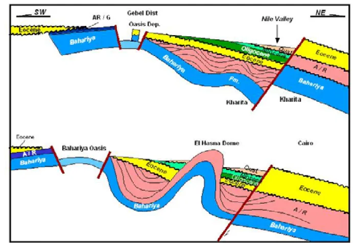
A schematic geologic cross section illustrates the surface geology traversed on the way to the Bahariya Oasis (Figure 10).
Figure 10 Schematic cross-section of features traversed from Cairo to Bahariya Oasis.
From Cairo driving southwest, one passes progressively deeper through the Tertiary section, finally dropping abruptly into the Oasis where the Cenomanian Bahariya Formation is extensively exposed. These exposures provide a unique opportunity for studying the depositional history of the Bahariya Formation.
A depositional model developed through the integration of outcrop and subsurface core and log data serves as a platform for discussion in the field. The ultimate explorationist’s goal is to utilize surface models to calibrate
subsurface depositional facies and sequences. Figure 10 also illustrates some compressional structural styles addressed in more detail at stop 1, as well as Oligocene exposures discussed at stop 2.
Structural Setting of the Western Desert and Bahariya Oasis
The regional development of the Upper Cretaceous in the Western Desert have been described by (Deibeis, 1976; Ghorab et al., 1970). These studies all demonstrate that tectonic movement during the Upper Cretaceous resulted in large changes in thickness as well as rapid variations in lithology.
The geology of the Bahariya Oasis has been dealt with by many authors (Akkaad and Issawi, 1963; Ball and Beadnell, 1903; Hermina, 1957; Lebling, 1919; Stromer, 1914, 1936; Weiler, 1935). A number of additional studies have been carried out in later years on certain areas or certain aspects of the geology of the depression (Bassyony, 1972; Khalifa, 1977; Soliman et al., 1970) .
The oasis of Bahariya lies between latitudes 27o 48' and 28 o30' north and between longitudes 28 o 35' and 29 o 10' east to the west of the Nile Valley and occupies the contact between stable and unstable shelf (Said, 1962). Bahariya is a large natural excavation, entirely surrounded by escarpments, with a large number of isolated hills within the
depression. The general shape of the depression is oval with its major axis running northeast with a narrow
blunt-pointed extension at each end. Its greatest length from northeast to southwest is about 94 kilometers. Its greatest width measured at right angles to its length is about 42 kilometers. It thus covers an area of approximately 1800 square kilometers.
.
The Bahariya Oasis is the main source of iron ore for the steel industry in Egypt. Iron in the oasis is of hydrothermal origin where iron-rich solutions have replaced Middle Eocene Limestone of the Naqb Formation (Hussein and Sharkawi, 1990). Iron is presently exploited from the El Gedida area (northeastern plateau of the Oasis), although it is found in other areas like Gebel Ghrobi.
The stratigraphic rock units that make up the geology of the oasis are as follow from top to bottom (Table 1 and figure 11-12).
Table 1- Composite stratigraphic section of Bahariya Oasis. Compiled from Said (1962), (Issawi, 1996; Said, 1962).
The floor of the depression exposes a large expanse of flat-lying Cenomanian fluvial sandstones. Around the margins these pass upwards into the terrestrial to marine transitional clastic beds well known for their vertebrate fauna
(Slaughter and Thurmond, 1974; Stromer, 1936). This is followed by a carbonate bed named the El Heiz Bed (Hermina, 1957). Above this, a mixed lithological section of dolomites and clastics, the Hefhuf Formation, can be traced around much of the rim of the depression, but is absent in part of the northern area where pre-middle Eocene
erosion has breached the crest of the dome down to the Cenomanian clastics. Maastrichtian to Danian age chalky limestone (Farafra Chalk ; Issawi, 1972) is present in southwest of the oasis below the Eocene Carbonates.
The chalky limestone is known in the subsurface as the Khoman Chalk. The chalk is separated from the underlying Hefhuf Formation by an interval of about 10 meters of dolomitic and phosphatic sandstone dated by a fish fauna as Campanian and correlated with the Duwi phosphates of the Dakhla and Kharga Oases. The younger age formations of Eocene, Oligocene and Early Miocene are summarized in Table 1 and their distribution in figures 11 and 12.
The depression of the Bahariya Oasis is an anticline of considerable extent oriented NE/SW, a typical structure of the Syrian Arc belt. The axis of this great anticline runs in a southwest trend from Gebel Ghorabi in the north, past the central hills of the depression to the southern part of the oasis, and seems to continue south to include the Farafra structure. Although the axis of this anticline cannot be traced continuously in the field, the alignment of the different structures within the depression as well as the stratigraphic succession are evidence that the anticline forms one unit. The dips are as high as 60o in the north and become less pronounced in the south, thus showing that the center of the deformation is in the north.
Figure 11 Geological map showing formations and major fault and fold trends in the Bahariya Oasis. Modified after Ball and Beadnell (1903).
The landsat image of the Baharyia Oasis shows the anticline orientation and the NE/SW fault zone cutting across the center of the oasis (Figure 13). Synclines of Gebels Radwan, El Hefhuf and El Harra are associated with this central fault and contain younger age formations such as the El Heiz, El Hefhuf and Radwan formations.
Figure 13. Landsat imagery of the oasis. Tectonic History of Bahariya Oasis
Several workers have revised the tectonic history of the Bahariya Oasis. Said (1962) first summarized the tectonic history of the oasis. Said noted that after the deposition of the thick Cenomanian Bahariyia clastics, folding took place. The northern part of the oasis continued as a positive area during Turonian and Santonian time. To the south, the structure was submerged, and Turonian-Santonian beds onlap Cenomanian strata. Further folding took place after the deposition of the El-Hefhuf Formation and the anticlines of the eastern scarp became even more pronounced.
The whole area became land during Santonian and lower Senonian time. During the Maastrichtian, the western and southern parts of the oasis were submerged and received the massive chalks of that age. The whole oasis was then uplifted and stood above the Paleocene and lower Eocene seas as an island. It was only during the middle Eocene time that the whole structure was submerged. The rocks of the middle Eocene, therefore, progressively overlap
Cenomanian Bahariya beds in the north, El Hefhuf beds of Turonian-Santonian in the southeast, chalk beds in the southwest, and Esna shales of the Upper Paleocene age in the south of the oasis along the road to Farafra.
The ages of these faults and the accompanying basalts are difficult to determine. Some are of post Turonian-Santonian age, but many may be of post Eocene (possibly Oligocene). Many workers believe that the Bahariya Oasis was developed as a result of right lateral strike slip movement along the pre-existing NE-SW fault trend.
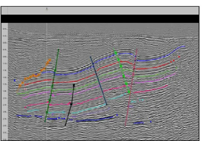
Interpretation of a seismic line from a typical profile in the Western Desert (Figure 14) provides an idea of the main tectonic events.
Figure 14 A typical seismic line (time) from Rezzak Field illustrating major tectono-stratigraphic events in the Western Desert.
• Pre-rift stage-- restricted to the pre-Jurassic and older strata. There is a mega sequence boundary between the pre-rift Jurrassic rocks and the overlying syn–rift Cretaceous rocks.
• Syn-rift deposits--developed as an early extension phase of rifting due to active faulting. The syn-rift
sediments are common in the Lower Cretaceous Alam El Buieb Formation. Late Triassic and Jurassic syn-rift deposits are also present, with an intervening transgression (Masajid carbonate) separating pulses from the Jurassic and early Cretaceous Alam El Buieb Formation. Seismic lines show that the syn-rift sediments have thick sediments on the hanging walls and thin sediments on the footwalls.
• Post rift deposits--extended from late Lower Cretaceous to early Upper Cretaceous (Alamein Dolomite, Kharita and Bahariya formations). These sediments attain relatively uniform thickness above the syn-rift sediments.
• Inverted structures-- developed due to compressional forces shortening the pre-existing rifts. Syn-inversion tectonics took place late in the Upper Cretaceous (Abu Roash G to Eocene Apollonia Formation). These
sediments thin near the compressional fault and thicken away from it. Many oil traps in the Western desert seem to be controlled by the inverted tectonic event.
The inverted nature of the Bahariya Formation is apparent from seismic to the north (Figure 15). Post-Cenomanian age formations onlap the core of maximum compression in the northern and southern limbs of the oasis and along synclines associated with the northeast-southwest central fault (figures 11 and 12) suggesting that inversion tectonics affected the geometry of the oasis. However the oblique NW-SE and N-S faults which accommodated lesser extension developed during Eocene or younger ages, gives a complex appearance of the inverted structure of the oasis.
Stop No. 1
This stop is located 25 kilometers southwest of Cairo just outside of the Qarun Base production facilities for Qarun Petroleum’s Qarun, North Qarun, Southwest Qarun and Al Ahram (WD-19) fields operations. The Qarun fields are Syrian Arc compressional fold structures that produce oil from Abu Roash, Bahariya, and Kharita reservoirs (figures 15-19).
Figure 15 NW/SE 3D seismic profile over Qarun Field and the northeast flank of North Qarun Field. Both fields are Syrian Arc compressional fold structures that produce from Bahariya and Kharita sandstone reservoirs (illustration courtesy of Apache Corporation, Ocean Energy and Qarun Petroleum Co.).
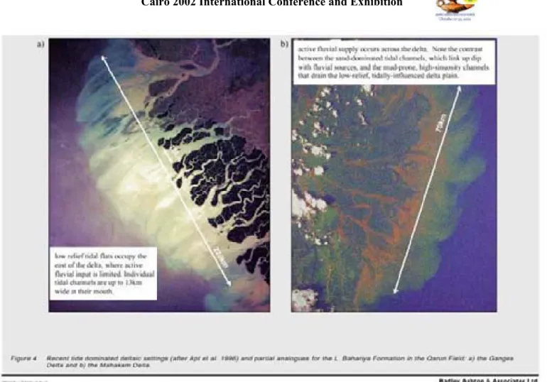
At this locality, from detailed reservoir characterization studies, the lower Bahariya sands have been interpreted as formed in tide dominated estuarine deltaic setting. Typical reservoir architecture is stacked anastomosing and amalgamated channel facies (figures 16-18).
Figure 18 Lower Bahariya stratigraphic cross section through Qarun Field, illustrating internal stratigraphic complexity and stacked amalgamated channel facies (Harris, 2001).
A schematic map of the Qarun area shows the relationship of the field to the larger inversion trend.
Figure 20 Dip profile through Al Ahram Field Structure. The Cretaceous section exhibits thickening updip toward the inverted structural feature, formerly a paleo-low. See Figure 18 for location.
Stop No. 2
Along the road to the Baharyia, nearly 250 kilometers southwest of Cairo, Eocene rocks form a scarp at the edge of the Bahariya Oasis. As discussed earlier, Eocene strata are absent at the core of the oasis, but onlap around its flanks, as well as being bevelled by and angular unconformity of Oligocene age. During the Eocene and early Oligocene, the oasis and many of the surrounding Syrian Arc structures formed islands in a shallow carbonate sea (Figure 21).
Figure 22 Late Eocene paleogeography (modified from (Dolson et al., 2002 (in press)). The regional geological sections indicated are not included in this guidebook. The drainage networks shown were well developed by
Oligocene time, when the ancestral Nile Delta probably lay west of its present position, flowing down the axis of the Abu Gharadig Basin.
A Stop 2, shallow Eocene dish-shaped reefs are exposed. These bioherms formed around the flank of the exposed Bahariya landmass. The dish-shaped reefs formed isolated bodies where the soft shales between the reefs have been eroded by weathering. Many nummulitic limestones occur along the slopes of the reefs. The reef top consists primarily of large Carolia oysters. True open ocean reef trends were most likely deposited along the Mediterranean coastline (as shown in Figure 22), and have since been heavily eroded by both Messinian and Oligocene exposure events. These smaller reefal bodies at Stop 2 are most likely patch reefs developed in large restricted back-reef lagoons along the edges of the exposed landmasses and on paleotopographic structural highs.
Stop No. 3
This stop is at the entrance to the oasis. We will examine the angular unconformity between Eocene rocks and the underlying Bahariya Formation.
Stop No. 4
Stop 4 is located 3 kilometers southwest of Stop 3. Here one can see panoramic views of the angular unconformity between the Bahariya Formation the overlying Eocene carbonates. In addition, the main faults running parallel to the axis of the oasis are well exposed. At this locality, we will discuss the geology, tectonic history and seismic lines from some oil and gas fields within the context of structural evolution of the Western Desert.
Stop No. 5 Gebel Mendisha
Columnar Oligocene basalt sheets cover the Baharyia Formation at Gebel Mendisha (Figure 23). The basaltic eruptions took place during Oligocene, when the Gulf of Suez rift began to open. As noted earlier, hyydrothermal solutions associated with this volcanic activity caused intensive mineralization and iron precipitation in parts of the oasis. Bahariya Oasis is well known for its source of iron ore deposits, which were an important reason Greek and Roman settlements were built here over 2000 years ago. Iron forms as a replacement to Eocene limestone where open cast quarries are located in several places (Hussein and Sharkawi, 1990).
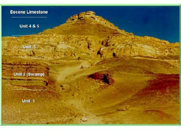
Figure 23 Columnar basalt sheet (dark-collared unit capping the ridge) covering the top of the Bahariya Formation. Stop No. 6 Gebal El Dist
We will examine two measured sections at this stop (figures 24-26). Several lithologic units have been recognized. Unit 1-- Rippled sandstone and shale (tidal flat/bay deposits?)
This lithofacies forms the base of Gebel El Dist (Figure 24) and it is almost covered by recent sediments. The
sandstone is fine grained, brownish to greenish grey, bioturbated and contains a low diversity, high abundance faunal assemblage of dominantly oyster shells. Ripples and flaser bedding are the diagnostic features of the sandstone. The shale interbeds are gray, fissile and non calcareous. The presence of ripples, some burrowing and oyster shells suggests deposition in a shallow, slightly agitated, restricted marginal marine environment (possibly tidal flat or bay deposits). The occurrence of flaser bedding suggests tidal influence (Reineck and Wunderlich, 1968).
Figure 24 General view of Gebel El Dist showing different lithofacies. This outcrop section is 106 meters (350feet) thick.
Unit 2-- Shale with thin rippled sandstone layers (swamp environment)
The shale is dark grey to reddish brown, highly carbonaceous and lignitic, with thin layers of rippled carbonaceous sandstone, fossil leaves, iron concretions, oyster shells and abundant dinosaur bones (Stromer, 1914, 1936). Roots are very common in this unit (Figure 27a). This lithofacies probably formed in low energy swamp environments
(Hassouba et al., 1988). The top part of this unit has an irregular topography caused by an erosional unconformity. Stacked paleosols are well developed beneath this unconformity surface. These paleosol layers (Figure 27b) are characterized by the dominance of reddish brown iron concretions and pisolitic ironstone layers.
Figure 27 Iron-stained roots within unit 2, Gebel El Dist. A) rootlets B) iron concretion layers
Figure 28 The east facing side of Gebel El Dist showing erosional contact (unconformity surface) between the fluvial sandstone (the area between solid lines) and the underlying swampy facies (reddish brown color).
Unit 3-- Cross bedded sandstone with erosional base (fluvial channel)
Two measured sections show the thickness variation of this lithofacies. The first section (Figure 25) shows the cross-bedded sandstone directly overlying and partially eroding the underlying swampy facies. Here it has an average thickness of 15.2 meters (50 feet). The second section is located about 600 meters to the northeast. Here, the cross-bedded sandstone is more than 38 meters (125 feet) thick and it is deeply incised onto the underlying swamp facies of Unit 2 and Unit 1 (tidal flat facies).
This thickness variation reflects infill of a significant erosional surface, which increases in magnitude northward. Lag deposits composed of dinosaur bones and oxidized mud clasts rich in oyster shells are observed on the top of this erosional surface, particularly in the area of the deepest incision. The lag deposits were produced from the underlying swampy and tidal flat lithofacies. The cross-bedded sandstones overlying the unconformity surface occur as stacked and almalgamated channels. Thin lenticular-shaped mudstone layers occur between the sandstone beds. The
sedimentary structures from bottom upward are as follows: 1) trough cross bedding (Figure 29 )
2) tabular cross stratification (Figure 30)
3) convolute bedding (Figure 31) and climbing ripples at the top (Figure 32).
The crossbeds dip north 30o east in the lower portions, but north 60o east in the upper parts of the sandstone. This unit is interpreted as stacked and laterally accreting fluvial channels, on the basis of the presence of erosional base with a basal lag followed upward by cycles of trough and tabular cross stratification and then convolution bedding with low mud content (Hassouba et al 1988) as shown in Figure 33.
Figure 30 Large-scale tabular cross bedding overlying the trough cross bedding.
Figure 31 Convolute bedding at the top of the point bar.
Figure 33 Block diagram showing depositional environments of the fluvial channels filling the lower part of the incised valley at Stop 6.
Unit 4-- Shale with basal sandstone beds (tidal flat and transgressive central basin mud)
This unit is separated from the underlying fluvial sandstone by a well developed, tens of centimeter thick layer of medium to very coarse grained transgressive sandstone characterized by wavy bedding (Figure 34). The section above this transgressive unit is almost completely covered by recent sediments, but, where exposed, consists mainly of shale and sandstone. The shale is gray to greenish gray, fissile, silty, sandy and non-calcareous, changing vertically to brownish gray. This change is due to subaerial exposure and development of a capping paleosol. A hard ferruginous layer contains Exogyra columba, Ostrea flabellata and other fossils documented by Stromer (1914). The basal inter-bedded sandstone layers are fine grained and characterized by flaser bedding. They are also slightly laminated with cryptic bioturbation (Figure 35).
Unit 4 seems to be deposited above a transgressive surface of erosion. The basal sandstones appear to be tidal flats based on the flaser bedding and cryptic bioturbation. The overlying bioturbated shale beds was deposited in a restricted marine to brackish environment, possibly in a central basin of an estuary or bay, based on the faunal contents as described earlier by Stromer (1914). The presence of thin transgressive fossil lags within the shale
recorded successive periods of relative sea level rises and continuous shift of the central basin muds landward, causing drowning of the underlying fluvial facies.
Figure 34 Transgressive surface of wavy bedded conglomeratic sandstone, Unit 4. A detailed interpretation of the depositional environment will be discussed later.
The upper parts of the shale beds are dark brown and contain oxidized pisolitic ironstone layers and iron concretions. This is almost certainly a paleosol horizon that may have been developed due to relative lowering of sea level, perhaps on an unconformity surface (Figure 36).
Figure 35 Faintly laminated sandstone with cryptic bioturbation.
Unit 5-- Shale, siltstone and sandstone with basal lag (brackish to restricted marine)
Unit 5 is separated from Unit 4 by a sharp surface boundary created by subaerial exposure and erosion. This surface is characterized by a Glossifungites ichnofacies overlying very coarse transgressive lag deposits consisting of oxidized clasts of mudstone, wood fragments and limestone (Figure 36). The deposits overlying this surface consist of
bioturbated coarsening upward beds of carbonaceous mudstone, siltstone and fine-grained sandstone (Figure 37). The top part is rich in bivalve fossils (Stromer, 1914).
The occurrence of coarsening upward cycles of shale, siltstone and sandstone with basal lag deposits consisting of wood fragments and brackish type restricted marine fauna (fish teeth, Exogyra columba, Gigantichthys spines) suggest deposition in a deltaic or estuarine environment. This is similar to the valley fill sediments of the Upper to Lower Recluse Members, Muddy Sandstone, Powder River Basin Wyoming (Martinsen, 1994).
Figure 36 Well-developed unconformity surface with basal lag deposits Glossifungites ichnofacies.
Figure 37 Coarsening upward cycles of laminated siltstone and mudstone.
Stop No 7--Gabel El Magrapha
The following lithofacies are recognized (figures 38 and 39):
Unit 1-- Shale with thin rippled sandstone layers (swamp environment)
This unit is similar to and correlated with unit 2 in Gabal El Dist. The top part of this unit is characterized by the occurrence of a Glossifungites surface composed of Thalassinoides trace fossils (Figure 40), overlain by oyster fossil hash suggesting a transgressive surface of erosion.
Figure 40 Glossifungites surface characterized by Thalassinoids traces filled with coarse debris from overlying strata. Unit 2-- Shale beds with basal transgressive fossil lags and cross stratified sandstone (bay fill and tidal flat?)
Unit 2 overlies a transgressive surface of erosion at the top of Unit 1. Shale layers are greenish to gray, rarely bioturbated and fissile, grading to reddish brown and very hard mudstone at the top. Each shale bed is overlain by cross-stratified sandstone. The sandstone is greenish grey to yellowish, fine to medium grained and coarsens upward. Each sandstone bed is capped by bivalve shells.
The sandstone exhibits large cross stratification with elongated mud drapes (Figure 41) and internal flaser bedding. The common occurrence of flaser bedding is an evidence of tidal flat environment and the mud drapes indicate slack water period (Banerjee, 1989; Terwindt, 1981). Coarsening upward sandstones, in conjunction with these other structures, suggest depositions in tidal bars. The mudstone interbeds could be the mud flats. The absence or rarity of burrows in this facies suggests the rate of sedimentation was too high or the salinity was too low to support burrowing organisms (Shanmugam et al., 2000).
Figure 41 Cross-bedded sandstone with elongated mud drapes.
Unit 3-- Cross-stratified sandstone with erosive base and fossil lag (tidal channel)
Unit 3 overlies an erosional surface (Figure 42). The sandstone is tan, fine-grained and has an erosional base. Oxidized mud clasts and fossil hashes were deposited above this contact. Planer and trough cross stratification with mud drapes and flaser bedding is common. Cryptic bioturbation is also very common.
The occurrence of the sandstone in fining upward packages deposited over erosional bases and in-filled with fossil hashes and cross stratification containing flaser and lenticular bedding suggests an origin as tidal channels.
Shanmugam et al., (2000, p.656) have described similar facies in Napo formations (Cretaceous) of Sacha Field in the Oriente Basin of Ecuador.
This unit may be correlated with a very well developed tidal channel at Naqb El Sellem (Stop No. 8, located about 85 kilometers from this location).
Figure 42 Cross-bedded tidal channel sandstone with basal erosional contact and oyster shell lags. Unit 4-- Shale with thin sandstone beds (tidal flat and tranrgressive central basin mud)
This unit is almost covered, but is similar to and correlated with unit 4 in the Gabal El Dist measured section. The upper part of the shale bed is dark brown, with a prominent dark brown soil horizon at the top, possibly an unconformity surface.
Unit 5-- Shale, sandstone and siltstone with basal lag (brackish to restricted marine)
This unit is similar and correlated with Unit 5 in the Gabal El Dist. Contorted bedding is common in the coarsening upward cycles.
Stop 8 (Naqb El Selem)
This stop has well developed laterally migrated channels (Figure 43) which cut into the underlying laminated mudstone and sandstone with plant leaves and mud cracks of a tidal flat environment. The channel fill sand is finely laminated with cryptic bioturbation suggesting a tidal origin of the channel system. Also, a well developed inclined bedding with elongated mud drapes of tidal origin (Figure 44) similar to what have been described by Shanmugam et al. (2000) can be seen around the channels. Overlying the channels sandstone is a succession of shale and bioturbated sandstone (Figure 45) of an estuarine environment similar to the facies succession that was deposited above the fluvial and tidal flat facies in Gabal El Dist and Gabal El Magrafa.
Figure 43 Channel fill sandstone with erosional surface cut into laminated sandstone and mudstone.
Figure 45 Exposed surface of bioturbated sandstone.
Depositional Environment and Sequence Stratigraphy Incised valley fill model
The key to interpreting depositional environment and sequence stratigraphy in our case study is the presence of multiple unconformity surfaces bounding the different facies. The stratigraphic cross-section of Gebal El Dist and Gabel El Maghrapha show two well-developed unconformity surfaces (Figure 46). The lower and most pronounced unconformity surface is that at Gebal El Dist, where the surface exhibits irregular topography and deep incision into the underlying swamp sediments. Stacked paleosol horizons have been observed beneath this unconformity,
characterized by reddish brown iron concretions and pisolitic ironstone layers.
The erosional topography was produced during period(s) of subaerial exposure and the surface was later filled vertically with 1) fluvial sandstone 2) tidal flat facies and 3) central basin mud, indicating deposition during marine transgressions. The fluvial channel fill basal facies exists only in Gabel El Dist and the tidal flat facies is the
equivalent lithofacies at that elevation in Gebal El Magrapha. This is implies that the incision had deeply eroded the tidal flat facies and part or all of the swamp facies in Gebal El Dist, as suggested in Figure 46.
The most significant sedimentary features indicating tidal processes in Bahariya outcrops include the following: • Cross-bedding with mud drapes
• Elongate mudstone clasts • Cryptic bioturbation
• Presence of interpreted tidal channels.
The vertical succession of facies from fluvial to tidally influence bayhead deltas and central basin muds is similar to the incised valley deposits in wave dominated estuaries (Zaitline et al., 1994). The major difference may be that the Bahariya sections are missing a tidal inlet barrier facies at the top of the valley fill. At least part of the Bahariya Formation at the oasis, then, may have developed as an incised valley filled within a tide dominated estuary (Figure 46).
Another unconformity surface on top of the underlying central basin mud is suggested by a subaerial exposure surface (iron concretions and pisolitic layers occur below the unconformity surface). This may suggest a relative lowering of sea level and a basinward shift of facies. The sediments filling this valley are composed basal lag deposit consisting of wood fragments overlain by coarsening upward cycles of bioturbated shale, siltstone and sandstone. A similar vertical succession of fluvial to estuarine valley-fill sediments occur in the Muddy Sandstone of the Powder River Basin, Wyoming (Martinsen, 1994).
Figure 47 Wave dominated estuary model (Martinsen, as cited in caption). Stop 9 (Gabal El Calcite)
Prior stops have dealt with the facies and stratigraphy of the Bahariya Formation. At this locality, however, there are well-exposed caves and paleokarst topography developed within the Maastrichtian Khoman chalk. The paleokarst topography comprises huge collapsed breccias and paleocaves with columnar-shaped stalagmites. The collapsed breccias are composed of meter-sized rounded chalky limestone blocks within the massive Khoman Chalk, The outer surface of the breccias are surrounded concentric layers of stratified and centimeter-sized and triagonal clean calcite crystals. Black to dark brown impurities occur between and along the crystal boundaries.
The paleocaves (Figure 48) are composed rimmed with the calcite crystals. The caves seems to be developed around the brecciated blocks that later on dissolved leaving concentric layers of secondary coarse crystalline calcite around the leached blocks. Some of these caves are filled with laminated reddish colored clay, silt and coarse sand of channel origin (cave floor fill).
The caves were probably produced by episodes of subaerial exposure during multiple exposure events known from Maastrichtian through Oligocene time. The paleoclimate during this period in Egypt was considerably wetter, with monsoonal and even tropical rain forest climates during the late Eocene and Oligocene (Bown and Kraus, 1988). Production in the Abu Sannan gas field is from the Khoman Formation (Ibrahim, 1992). Khoman production is relatively uncommon in the Western Desert. It is possible that this production is related to karsting of the Khoman Formation as observed in this field trip stop. Similar karsted terrains have been described in the Jurassic of southern France (Charcosett et al., 2000).
Figure 48 Karstified topography. A) caves composed of coarse calcite crystals B) reddish brown laminated fluvial sandstone filling the caves floors C) limestone breccia filling the caves.
Subsurface study of the Bahariya and Kharita formations—Abu Gharadig and Rezzak fields
At Abu Gharadig Field, the Bahariya Formation may be tentatively subdivided into upper and the lower zones (Figure 49).
Figure 49 Stratigraphic zonation of Baharyia and Kharita formations at Abu Gharadig Field showing the depositional environment of each formation.
Baharyia Formation
Generally the Baharyia Formation is composed of sandstone, mudstone and limestone (Figure 49). The upper
Baharyia is more shale rich than the lower Baharyia. The sandstones and mudstones are tan, greenish grey, glauconitic in parts and thinly interbedded with sandstone and mudstone. Other intervals are carbonaceous, with siderite nodules and local development of calcareous cement. Limestones are off-white, nodular and rich in oyster shells. The nodular limestone is caused by diagenisis around Thalassiniodes trace fossils.
Burrowing is common, particularly in the upper portions. The burrow types are a limited trace fossil assemblage indicative of brackish bay environments (George Pemberton, personal communication from core examination)
including Planolites, Teichichnus and Thalassinoides (Figure50). The associated sandstones is relatively thick-bedded and rich in carbonaceous material (Figure 50a) and planer-bedded to rippled (Figure 50b) suggesting deposition in a tide dominated deltas and bay fill deposits. Evidence of tidal influence includes cryptic bioturbation (Figure 51a), basal tidal channel breccias (Figure 51b) and Arenicolites trace fossils (Figure52a).
At Rezzak Field similar environments were periodically inundated by normal marine waters, since Zoophycus traces have been found overlying Glossifungites surfaces in cores (Figure 54a). In addition to Zoophycos, there area Asterosoma burrows (Figure 54b) indicative of a lower shoreface environment. At Abu Gharadig Field, Zoophycus burrows have not been found, either not having been cored in some intervals where they may be present, or, more likely, they simply do not exist to the south at this field. This is consistent with a general northward increase in the amount of marine influence seen regionally in most Western Desert Cretaceous reservoirs. The Zoophycos burrows are more common in outer neritic and deeper bathymetric depths (George Pemberton, personal communication).
Figure 55 is a block diagram showing the depositional environment of the Bahariya Formation at Abu Gharadig Field. The upper portion of the Bahariya is more rich in marine shales and trace fossils, reflecting transgressions.
Figure 56 is the sand/shale ratio map of the upper Bahariya in Abu El Gharadig Field.
Figure 50 Core photograph from Rezzak Field of thinly interbedded sandstone and mudstone with restricted marine trace fossils.
a
a
b
Figure 51 Core photograph from Abu Gharadig field A) massive sandstone rich in organic matter B) planer to rippled laminated sandstone.
a
b
Figure 52 Core photograph in tidal flat environment a) lamination with cryptric bioturbation B) basal channel breccia.
a
b
Figure 53 Core photograph from Abu Gharadig Field A) bioturbated sandstone in a tidal flat facies B) transgressive surface between white nodular limestone rich in Thalassoniodes traces (subtidal to restricted environment) and an overlying glauconitic sandstone of marine origin.
a b
Figure 54 Core photograph from Rezzak Field A) glauconitic muddy sandstone with Zoophycos traces suggesting an upper offshore marine environment B) glauconitic sandstone with Asterosoma traces indicating a lower shoreface environment.
Figure 56 Sand/shale ratio map of the upper Bahariya at Abu Gharadig Field Kharita Formation--Abu Gharadig and Rezzak fields
Kharita strata are much sandier than the overlying Bahariya Formation. Generally, the Kharita Formation in both fields is composed of thick-bedded fining upward sequences of coarse to medium grained carbonaceous sandstone barren of microfossils. The most common sedimentary structures are large-scale trough cross-bedding overlain by tabular cross-bedding (Figure 57a). These are in turn overlain by small syn-depositional faults filled with fine-grained sandstone and silts. The sections barren of fauna are interpreted as a fluvial channel deposits In some wells, there are interbeds of fine-grained, bioturbated, rippled and occasionally flaser-bedded sandstone and mudstone couplets (Figure 57b). These latter intervals may comprise lower energy interdistributary bays in facies relationship with distributary channels. Alternatively, they may be truncated laterally by channels within incised valley networks. Additional work should be done to examine these different models.
a
b
Figure 57 Core photograph, Kharita Formation, Abu Gharadig Field A) fluvial cross-bedded sandstone B) thinly interbedded and bioturbated sandstone and mudstone bay-fill deposits.
Reservoir properties—Abu Gharadig Field
Thin section examination of the core samples allows classification of Bahariya reservoirs into three categories. An electric log model derived for core and cutting examination using gamma ray and neutron porosity curves (Figure 58) could generally guide recognition of reservoir quality and environment within the Bahariya Formation.
Figure 58 Electric log model showing different reservoir quality and log facies in Abu El Gharadig Field, Bahariya and Kharita formations.
Fair to good quality reservoirs at Abu Gharadig field are generally within the thick-bedded sandstones of the lower Bahariya and Kharita formations. Pore throats are rectangular, due to silica overgrowth (Figure 59). The permeability of the rock would be slightly affected by the presence of some clay minerals and carbonate cement within the pore spaces (Figure 60). The environment into which these sandstones were deposited is mainly fluvial.
Figure 59 Photomicrograph in good quality reservoir, medium to coarse-grained sandstone with rectangular shaped pore spaces created by silica overgrowth. PL x 200.
Figure 60 Photomicrograph in good quality reservoir sandstone. The pore spaces are partially filled with authigenic kaolinite (K) and dolomite cement (D). PL x 200
Fair quality reservoir is mainly found within the Upper and Lower Bahariya in the bay fill and tidal flat environment. The sandstone is finer in grain size compared to lower Bahariya and Kharita zones described above. The estimated visual porosity is reduced due to partial compaction and the presence of a clay matrix and carbonate cements (figures 60 and 61).
Figure 61 Photomicrograph in fair to good quality reservoir sandstone (Upper Bahariya) with detrital clay in the pore spaces. Pl x200.
Figure 62 Photomicrograph in fair quality reservoir sandstone with authigenic clay in the pore spaces (Upper Bahariya). PL x 50
Poor quality reservoir is found within the thinly interbedded sandstone and mudstone in the distal portions of the bayhead deltas, mixed tidal flats and upper offshore marine facies. These reservoirs consist of thin layers and laminae of sandstone and mudstone. The rock is rich in squeezed clay pellets and calcareous cement.
Figure 63 Photomicrograph in poor quality reservoir, calcareous glauconitic sandstone. XP x50
Sea level fluctuation during Upper Cretaceous time
Hassouba et al.(1988 ) referred to sea level fluctuations through deposition from the Kharita to Abu Roash formations (Abu Roash A to F). Figure 65 shows three abrupt changes (regressions) that took place during the depositional history of the Abu Roash and Kharita formations. The largest regression occurred during deposition of the Kharita Formation. Another one took place at the end of Abu Roash F deposition and the top part of Abu Roash E. The last one took place at the end of the Abu Roash D.
Figure 65 Relative sea level fluctuations in the Upper Cretaceous, Western Desert
Such large regressions were accompanied by development of an unconformity surface (sequence boundary) that separates Albian (Kharita Formation) from the underlying Aptian Dahab Shales. Thick high quality Kharita
sandstones were deposited over the sequence boundary in stacked braided channels that have an extensive geographic distribution. During subsequent transgressions, the shalier and more marine Bahariya Formation lithologies were deposited. The transgressions were intermittent and left numerous smaller scale sequence boundaries in parts of the Bahariya and Abu Roash formations. Generally, the Abu Roash formations represent the highest relative sea level rises and become more carbonate prone than the underlying units.
GUPCO and other companies are currently studying the higher resolution architecture of the reservoirs within these smaller scale sequences in order to find additional traps and unexploited hydrocarbon intervals in the Western Desert.
Archaeology of and other items of interest in the Bahariya Oasis
Table 2. Web links to information on dinosaurs and the Valley of the Golden Mummies in Bahariya Oasis Dinosaurs of Egypt (some recent
discoveries from Bahariya may be among the largest dinosaurs ever discovered)
http://www.egyptdinos.org/
Golden Mummies of Bahariya http://www.washington-report.org/backissues/1099/9910103.html
Golden Mummies http://www.guardians.net/hawass/Valley_of_the_Golden_Mummies.htm
Golden Mummies http://news.nationalgeographic.com/news/2001/03/0329_goldenmummynew.html
Golden Mummies, Bahariya in general
http://www.egyptvoyager.com/drhawass.htm
The following discussion on archeology is excerpted directly from (Vivian, 2000). Bahariya Oasis
Bahariya is the closest oasis to Cairo in kilometers, but the most distant oasis in time. Although Siwa remained closed to the outside world until the last decade, its modernization has been rapid. Kharga and Dakhla, the major oases in the New Valley Governorate, have grown and expanded at an equally amazing rate. Farafra is exploding. But Bahariya Oasis, part of the highly populated Giza Governorate, has been slow to move into the modern world. Of course, for the traveler in search of the past this is wonderful; for the people of Bahariya it must be very frustrating
History
Like all the other oases, Bahariya has had many names through the centuries: Northern Oasis, the Little Oasis, Zeszes, Oasis Parva, and the Oasis of al-Bahnasa. It has plenty of ancient sites to illustrate its importance in antiquity.
Unfortunately, these ruins have yielded little information as too few of them are being excavated. No foreign mission operates in Bahariya. Local antiquities inspectors move at a very slow pace. The only comprehensive study of the antiquities of Bahariya was carried out by Ahmed Fakhry, the twentieth-century Egyptologist, who did extensive work in the Western Desert over sixty years ago. Fakhry published a number of books related to these excavations and most of the factual material known today was first presented in Fakhry's works.
Middle (C. 2040-1782 B.C.) and New Kingdoms (C. 1570-1070 B.C.)
We know practically nothing about life in Bahariya before the Middle Kingdom. If early peoples lived and hunted amid the mountains of this oasis the evidence is still hidden in the cliffs and hills. If the pharaohs of the Old Kingdom, ruling from what is modern-day Giza, had governors in this oasis as they did in Dakhla, we have yet to discover the evidence. In short, the early history of Bahariya is unknown.
In the Middle Kingdom, Bahariya, known as Zeszes, was under the control of the pharaohs. Caravans between
Bahariya and the Nile Valley were common. Donkeys (the camel was not introduced to Egypt until the Roman period) laden with goods, especially Bahariya wine, made their way regularly to the Nile Valley and its awaiting populace. Just as today, agriculture was of major importance in Bahariya during the Middle Kingdom and if there was agriculture there must have been large estates, houses for the landowners and laborers, military garrisons to keep marauders at bay, and all the services required to keep such establishments functioning.
Under Thutmoses III, the great warrior pharaoh of the Eighteenth Dynasty of the New Kingdom, Bahariya was under the control of Thinis (Abydos), to which it paid tribute and from which it received government services. According to Fakhry, Thutmoses controlled all of the oases and brought about many changes. It was a time of great improvement, with agriculture increasing, new wells being dug, and a rise in the population. Tomb scenes in the Nile Valley depict
tribute being paid to the governor by people from the Northern Oasis. The most interesting scene related to Bahariya is in the tomb of Rekhmire, Thutmose III's vizier. Here the people of the oasis, shock-headed and wearing striped kilts, are shown presenting gifts of mats, hides, and wine. By the Nineteenth and Twentieth Dynasties the mineral wealth of Bahariya was receiving attention in the Nile Valley. Such is the abundance of iron ore that it supports a still vital industry today.
Third Intermediate (C. 1069-525 B.C.) and Late Periods (625-404 B.C.)
It was in the later dynasties that Bahariya emerged as a major center in ancient Egypt and ample evidence for its importance exists in the antiquities found throughout the oasis. By the Twenty-sixth Dynasty, Libyans sat on the throne of Egypt and the expanse of desert that separated the Nile Valley from the Libyan homeland became a main artery of trade and traffic. Bahariya, situated in the center of this route, flourished. Fakhry believes the Libyans first captured Farafra and Bahariya, then used them as a base to conquer the rest of Egypt.
Shoshenq I, the founder of the Twenty-second Dynasty (c. 950 B.C.), took a keen interest in Bahariya when he came to the throne. His successor, Shoshenq IV, continued to develop the area and ordered that government officials were to live there. By the Twenty-sixth Dynasty, Bahariya had grown into an important agricultural and trade center with its own governors, natives of the oasis, who reported to the Libyan rulers on the throne of Egypt. The majority of ancient monuments found in Bahariya date from the Twenty-sixth Dynasty.
Roman (30 B.C.-A.D. 323) and Christian (323-642) Periods
Although prosperous, Roman times were not secure. Rule was harsh. The deserts were unsafe. Bedouin and marauders roamed and terrorized villages. Overproduction was turning once cultivated land into desert. Yet despite these
problems Roman rule resulted in a number of improvements, most impressive of which is the system of aqueducts and wells, several of which, in Bawiti and Izza, are still in use today. But such is the uncertainty of this period that even these have been questioned as actually being Roman and may date from an earlier time.
However, there can be no doubting the importance of Bahariya in Roman times, when many tombs, especially those cut into the sides of the mountains, were constructed. We are sure that Roman soldiers moved between Bahariya and Oxyrhynchus in the Nile Valley. In 213, tile Apriana Alae was stationed at the "Small Oasis" collecting grain. That there was heavy occupation in the northern part of the oasis to the east of Bawiti is certain, and the ruins of a major Roman city await the excavator.
By the Christian era Bahariya had a new name, the Oasis of al-Bahnasa. Enough Christians lived there for it to have its own Bishop and, according to Coptic tradition, Bahariya is where the martyrdom of St. Bartholomew took place. One of the original twelve apostles of Jesus Christ, Bartholomew was given the task of converting the oases of the Libyan Desert. According to Abu Salih, a prominent medieval Christian historian, Bartholomew met his martyrdom at
Bahariya on the first day of the Coptic month of Tut (Sept 7) at a place called Qarbil (unidentified today) and his body is believed to be buried in Sohag.
When Dugald Campbell visited Bahariya in 1931, thumping his bibles, he found a Coptic monastery standing in Bawiti. He called it Dar al-Abras, the Lepers' Refuge, and described it as having paintings, old writings, and engraved crosses on the walls. He says the Christians called Bahariya Mari Girgis (St. George) and in the rock tombs he found “old baked-earth coffins of the kind made in Carthage during the Punic period." Each had the figure of a Libyan man on the lid. He took some to the Cairo Museum.
Christians remained in Bahariya until the sixteenth and seventeenth centuries, far longer than in any other oasis. In fact, in the oral tradition related by Ahmed Fakhry, the people still remember the last Christian family to convert to Islam.