The contact zone between the ALCAPA and Tisza-Dacia
mega-tectonic units of Northern Romania in the light of new paleomagnetic
data
E
MÕM
ÁRTON1, M
ATTHIAST
ISCHLER2, L
ÁSZLÓC
SONTOS3, B
ERNHARDF
ÜGENSCHUH2, 4& S
TEFANM. S
CHMID2Key words: rotation, paleomagnetism, Tisza-Dacia, Carpathians, Transcarpathian depression, Northern Romania
ABSTRACT
Paleomagnetic analyses were carried out on samples from 19 localities within two different mega-tectonic units in Northern Romania: Tisza-Dacia (11 local-ities) and ALCAPA (8 locallocal-ities). The samples cover a range of different lithologies: (1) Late Cretaceous red-coloured marl to marly limestone, (2) Eo-Oligocene flysch sediments, and (3) mid-Miocene (Langhian) tuffite (Dej tuff and related sediments). The Late Cretaceous and mid-Miocene specimens carry secondary paleomagnetic signals exhibiting a counter clockwise deflec-tion of the paleo-declinadeflec-tions by some 30°, while the Eo-Oligocene localities indicate an overall clockwise deflected (between some 45° and >90°) paleo-declination with respect to present-day north. Clockwise rotation postdates the age of sedimentation (Lower Oligocene), as well as (at least partially) thrusting of the Pienides onto the Tisza-Dacia mega-tectonic unit, which oc-curred between 20.5 and 18.5 Ma. Clockwise rotation predates post-12 Ma counter clockwise rotations inferred for the mid-Miocene localities.
Surprisingly, the clockwise rotations of the first rotational stage not only affected the (par-) autochthonous sedimentary cover of the Tisza-Dacia mega-tectonic unit, but also the allochthonous flysch nappes of the Pienides, i.e. the eastern tip of the ALCAPA mega-tectonic unit. Well-documented opposed rotation of the remainder of ALCAPA necessitates a detachment of this east-ern tip of ALCAPA after 18.5 Ma. The most likely location for this detach-ment zone is along the margins of the Transcarpathian depression. During a second (post-12 Ma) stage, counter clockwise rotations of up to 30° affected the entire working area. Regarding timing and magnitude, these second stage rotations are similar to rotations documented for the East Slovak basin, but different from those reported from the South Apuseni Mountains and the Central and Inner West Carpathians located west of the East Slovak basin.
ZUSAMMENFASSUNG
An insgesamt 19 Lokalitäten in Nord-Rumänien wurden paleomagnetische Analysen in zwei grosstektonischen Einheiten durchgeführt: 11 Lokalitäten liegen im Tisza-Dacia Block, 8 sind Teil der ALCAPA-Einheit. Die unter-suchten Proben umfassen folgende Lithologien: (1) Oberkretazische rote Kalkmergel, (2) Eo-Oligozäne Flysche und (3) Tuffite (Dej-Tuff und assozi-ierte Sedimente) des Mitteren Miozäns (Langhian). Die Proben aus der Ober-kreide und dem Mittleren Miozän zeigen eine sekundäre Magnetisierung, deren Paläo-Deklination um ca. 30° gegen den Uhrzeigersinn rotiert ist. Die Paläo-Deklinationen der Eo- Oligozänen Proben hingegen weisen Abwei-chungen zu gegenwärtig Nord mit dem Uhrzeigersinn (45° und >90°) auf.
Die Rotation der Eo-Oligozänen Proben fand nach der Sedimentation der jüngsten Proben (unteres Oligozän), und zumindest teilweise nach dem Deckenschub der Pieniden (20.5–18.5 Ma) auf den Tisza-Dacia Block statt. Diese Rotation mit dem Uhrzeigersinn geht der durch die mittel- Miozänen Proben dokumentierten gegenläufigen Rotation (ab 12 Ma) voraus.
Die Rotationen der früheren Phase wurden nicht nur in den Sedimenten aus der (par-) autochthonen Bedeckung von Tisza-Dacia, sondern auch in den überschobenen Pieniden nachgewiesen. Dieses Ergebnis ist auf den ersten Blick überraschend, da sie Teil von ALCAPA sind, der Rest von ALCAPA zu dieser Zeit aber in einem gegenläufigen Sinn, also gegen den Uhrzeigersinn, rotierte. Diese gegenläufigen Rotationen erfordern also eine tektonische Ablösung der östlichsten Spitze von ALCAPA vom Rest dieser grosstekto-nischen Einheit. Der wahrscheinlichste Ort für eine solche Ablösung befindet sich an den Rändern der Transkarpathischen Depression. Die zweite Rota-tionsphase, ca. 30° gegen den Uhrzeigersinn nach 12 Ma, ist auch aus dem Ost-Slovakischen Becken bekannt. Sowohl die Internen West-Karpathen westlich des Ost-Slovakischen Beckens, als auch das südliche Apuseni Gebirge, zeigen nach 12 Ma ein vom Arbeitsgebiet abweichendes Rotationsverhalten.
1999; Márton 2000) and represent a central issue in the recon-struction of the Tertiary kinematics of these highly mobile units. In several tectonic reconstructions ALCAPA and Tisza-Dacia are treated as two distinct ”microplates” or ”blocks” (e.g. Fodor et al. 1999, Csontos & Vörös 2004), although both
Introduction
Opposed rotations of the two mega-tectonic units building the Carpathians, termed ALCAPA and Tisza-Dacia (Fig.1), are well established by paleomagnetic studies (e.g. Márton & Már-ton 1978, 1996; MárMár-ton & Fodor 1995, 2003; Panaiotu 1998,
1 Paleomagnetic Laboratory, Eötvös Loránd Geophysical Institute of Hungary, Columbus 17–23, H-1145 Budapest, Hungary 2 Geologisch-Paläontologisches Institut, Basel University, Bernoullistr. 32, CH-4056 Basel, Switzerland
3Physical and Historical Geology, ELTE University, Pázmány Péter sétány 1/C, H-1117 Budapest, Hungary 4 Institute for Geology and Paleontology, Innsbruck University, Innrain 52f, A-6020 Innsbruck, Austria 1661-8726/07/010109-16
DOI 10.1007/s00015-007-1205-5 Birkhäuser Verlag, Basel, 2007
mega-tectonic units were internally deformed. This is particu-larly true for their contact zone, the Mid-Hungarian fault zone, which continues into Northern Romania (Csontos & Nagy-marosy 1998, Fodor et al. 1999, Györfi et al. 1999, Tischler et al. 2007).
The invasion of the ALCAPA and Tisza-Dacia mega-tec-tonic units into the Carpathian embayment is thought to be driven by retreat of the European lithospheric slab (e.g. Roy-den 1988, Wortel & Spakman 2000) and is coupled to ”lateral extrusion” in the Eastern Alps (Ratschbacher 1991 a, b; Spern-er et al. 2002).
Final emplacement of these mega-tectonic units was ac-companied by substantial strike-slip movements, extension and/or block rotations (Fodor et al. 1999, Márton 2000, Cson-tos et al. 2002, Márton & Fodor 2003, Horváth et al. 2006). Corner effects at the Bohemian (Sperner et al. 2002) and Moe-sian (Ratschbacher et al. 1993, Schmid et al. 1998, Fügenschuh & Schmid 2005) promontories (Fig. 1) are considered as im-portant causes for the opposed rotations of continental units during their Neogene emplacement into the Carpathian em-bayment.
Converging movements partly also accommodated such ro-tations; they led to the juxtaposition, and finally the thrusting of ALCAPA onto Tisza-Dacia, as is documented by subsur-face and outcrop data (e.g. Csontos & Nagymarosy 1998, Györfi et al. 1999, Tischler et al. 2007) along the Mid-Hungari-an fault zone. The Mid-HungariMid-Hungari-an fault zone shows a poly-phase history, allowing for repeatedly occurring differential movements between the invading mega-tectonic units (e.g. Csontos & Nagymarosy 1998, Fodor et al. 1998, 1999). Most of the contact zone between the ALCAPA and Tisza-Dacia
mega-tectonic units is covered by the Neogene fill of the Pan-nonian basin, but it is exposed in the Maramures area (North-ern Romania).
In this paper two independent methods and studies are combined to better understand the tectonic evolution of the region, namely outcrop-scale structural studies (Huismans et al. 1997, Györfi et al. 1999, Tischler et al. 2007) and paleomag-netic investigations. The latter became possible since the re-cent regional tectonic study by Tischler et al. (2007) provided suitable outcrops for paleomagnetic sampling, in a generally badly exposed area with friable lithologies. The analysis of structural and paleomagnetic data sets was performed sepa-rately and was only combined in a last step. Paleomagnetically registered rotations were robust and extended beyond the study area. This leads us to propose a working hypothesis for the structural and rotational history of the area for the last 30 Ma.
Geological setting
The study area, located in northern Romania, at the northern margin of the Transylvanian basin, is in an internal position with respect to the main Carpathian chain. The crystalline basement and Mesozoic cover units, which crop out in the study area (Fig. 2), belong to the Tisza unit (Biharia unit) and the Dacia-unit (Infra- Sub- and Bucovinian nappes). Both units form a single Tisza-Dacia mega-tectonic unit since Early Tertiary times. These basement units have a poly-phase defor-mation history; their internal structure was formed during middle to latest Cretaceous times (Sa˘ndulescu et al. 1981). During Late Cretaceous and Paleocene times, a common
Fig. 1. Major tectonic units of the Alps, Carpathians and Dinarides (simplified after a yet unpublished compilation by S. Schmid, B. Fügenschuh, K. Ustaszewski, M. Tischler and L. Mat¸enco). The boxes mark the outlines of Fig. 10 and the study area, respectively.
sedimentary cover (”autochthonous cover” of Fig. 2) was deposited onto both Tisza and Dacia units, thus sealing all earlier tectonic contacts (Sa˘ndulescu 1994).
Eocene strata again un-conformably overlay these Late Cretaceous and Paleocene sediments. In the northern part of the study area a westward deepening of the depositional
envi-ronment is documented (local carbonate platforms and con-glomerates in the east, marly littoral-neritic facies in the west; Dicea et al. 1980, Sa˘ndulescu et al. 1981). In the southern part of the study area, continental to shallow marine environments prevail during the Eocene (Popescu 1984, De Broucker et al. 1998).
Fig. 2. Tectonic map of the study area, based on published geological maps (1:50.000 & 1: 200.000) of the Geological Survey of Romania, Dicea et al. (1980), Sa˘ndulescu (1980), Sa˘ndulescu et al. (1981), Aroldi (2001) and Tischler et al. (in press). Sampling localities are indicated.
Borsa Sighet Baia Mare Dej
P
P
Preluca fault
Preluca fault
Preluca fault
P
P
Bogdan-
Voda fa
ult
Bogdan-
Voda fa
ult
Dragos-Vod
a
fault
Dragos-Vod
a
fault
20 km
Neogene volcanics Neogene volcanics Bihor unit Bihor unit Pienniny type klippenPienniny type klippen and associated flysch and associated flysch
Transylvanides, Ceahlau-ysh nappes and Black flysh nappes and Burdigalian molasse Burdigalian molasse post- Burdigalian post- Burdigalian sediments sediments internal Pienides: internal Pienides: Botiza Nappe Botiza Nappe external Pienides external Pienides fault
fault thrust /thrust / reverse fault reverse fault normal normal fault fault 18 18 Neogene volcanics
Pienides (P)
Bucovinian nappes Biharia unit frontal scales of theBotiza nappe: Pienniny type klippen and associated flysch
Ceahlau- and Black flysch nappes
Eocene
Oligocene - Lower Miocene Burdigalian molasse
Moldavides
Moldavides
Miocene Thrust belt
Miocene Thrust belt
(Moldavides)
(Moldavides)
Miocene Thrust belt
Miocene Thrust belt
Moldavides
Moldavides
Miocene Thrust belt
Miocene Thrust belt
(Moldavides)
Miocene Thrust belt
post- Burdigalian sediments Locations: 1, 2, 3, 5, 18 Locations: 13, 14, 19 Locations: 12 Locations: 17 Locations: 6, 7, 15, 16 Locations: 8, 9, 10, 11
Locations: 4 Mid-Miocene Location
Eo-Oligocene Location Up. Cretaceous Location internal Pienides: Botiza Nappe external Pienides fault thrust / reverse fault normal fault
Upper Cretaceous- Paleocene
(Par-) Autochthonous
cover of Tisza-Dacia
Allochthonous
Tisza-Dacia megatectonic unit
8
7
4
1
9
5
6
3
2
19
19
18
18
17
17
15
15
11
11
10
10
13
13
16
16
12
12
14
14
8
7
4
1
9
5
6
3
2
19
18
17
15
11
10
13
16
12
14
Following a regional drowning event at around the Eocene/Oligocene boundary terrigenous siliciclastics have been deposited in a E-W to SE-NW oriented basin (De Broucker et al. 1998). A SE-ward thinning clastic wedge of Burdigalian age (”Burdigalian molasse”, Fig. 2), deposited in an ENE-WSW trending basin, is documented at the northern border of the Transylvanian basin (Ciulavu et al. 2002).
Coevally with the deposition of this clastic wedge, flysch nappes (”Pienides”, Fig. 2) have been thrust onto the au-tochthonous cover of the Tisza-Dacia mega-tectonic unit, leading to imbrication of this autochthonous cover in the Lower Burdigalian (20.5–18.5 Ma; De Broucker et al. 1998, Györfi et al. 1999, Tischler et al. 2007). The various units of the Pienides (Sa˘ndulescu 1984, 1994; Sa˘ndulescu et al. 1993) consist of Eocene and Oligocene flysch units and can be di-vided, from internal to external, into: Botiza nappe, Pieniny type klippen including associated flysch, and external nappes (Petrova, Wildflysch and Leordina nappes). The Pienides represent the eastern continuation of the Pieniny Klippen Belt and the Magura unit of the Western Carpathians (Sa˘nd-ulescu 1980). Hence they are considered as parts of ALCA-PA by most authors (e.g. Balla 1984, Csontos 1995, Kováç et al. 1994, Fodor et al. 1999, Tischler et al. 2007). Their em-placement onto the autochthonous cover of the Tisza-Dacia mega-tectonic unit is thought to represent the last increment of thrusting of the frontal part of ALCAPA onto Tisza-Dacia (see also Györfi et al. 1999). The direction of emplace-ment (SE-directed in present coordinates) is roughly perpen-dicular to the long axis of the wedge of the Burdigalian mo-lasse (Fig. 2). This supports the interpretation of the wedge-shaped Burdigalian deposits in terms of a foreland basin fill related to the emplacement of the Pienides, as was previous-ly suggested by De Broucker et al. (1998), Györfi et al. (1999) and Ciulavu (1999). During Miocene times the AL-CAPA and Tisza-Dacia mega-tectonic units were docked to
the European foreland, generating the Miocene thrust belt (Fig. 2).
Above a second regional unconformity dacitic tuffs (Dej Tuff) of Langhian (Badenian) age (post-16 Ma; this and all later conversions into an absolute time scale are after Grad-stein et al. 2004) were deposited onto both the Tisza-Dacia mega-tectonic unit and the Pienides, already thrust onto Tisza-Dacia. The source area of the volcanic activity is thought to be located NW of the study area (Szakács et al. 2000). Andesitic volcanic activity between 14–9 Ma (Pécskay et al. 1994) led to the formation of the volcanic body near Baia Mare (Fig. 2), which obscures the western continuation of the Pienides.
Starting in mid-Miocene times, two stages of strike slip dominated brittle deformation indicate ongoing deformation after the amalgamation of Tisza-Dacia with ALCAPA (Tis-chler et al. 2007). A first transpressional stage (16–12 Ma) is dominated by SW-NE compression; active map scale features are the Preluca fault and the Bogdan-Voda fault. This trans-pressional stage is followed by transtension (SW-NE compres-sion, with dominant NW – SE extencompres-sion, 12–10 Ma), represent-ing the main phase of left lateral movement along the so-called Bogdan- Dragos-Voda fault system. These deformations are most probably connected to left lateral transtension along the Mid-Hungarian fault zone (e.g. Csontos & Nagymarosy 1998). According to Tischler et al. (2007) substantial opposed-sense rotations across the Bogdan- Dragos-Voda fault system can be excluded for this late stage of the tectonic evolution.
Paleomagnetic sampling
Samples were collected at 19 localities (Table 1 and Fig. 2). They cover a range of lithologies and represent different ages and tectonic units. Great care had to be taken to avoid strata, which had been affected by recent gravitational creep or slid-ing, which is common in the study area. In addition, the need
Nr X Y Tectonic unit age lithology
1 24.0715 47.8040 Dej tuff Langhian tuff 2 24.2418 47.6984 Dej tuff Langhian tuff 3 24.1337 47.6965 Dej tuff Langhian tuff
4 24.1409 47.6456 Botiza nappe Sennonian (Turonian?) marly limestone 5 24.0414 47.8737 Dej tuff Langhian tuff/marl 6 24.2425 47.7750 Leordina nappe Ypresian-Low.rupelian marl 7 24.2407 47.7758 Leordina nappe Oligocene marl
8 24.0274 47.6019 Botiza frontal scales Cenomanian-Sennonian marly limestone 9 24.0292 47.6011 Botiza frontal scales Eocene marl
10 24.0357 47.6026 Botiza frontal scales Eocene marl
11 24.0254 47.5947 Botiza frontal scales Cenomanian-Sennonian marly limestone 12 24.4124 47.7375 Autochtonous Priabonian marl
13 24.3596 47.7297 Autochtonous Low. Rupelian menilithic marl 14 24.3238 47.7347 Autochtonous Low. Rupelian marl
15 24.3466 47.7347 Wildflysch nappe Lutetian - Priabonian marly silt 16 24.0699 47.8477 Petrova nappe Lutetian - Priabonian marly silt 17 24.4338 47.5447 Autochtonous Turonian - Priabonian marly limestone 18 24.2742 47.2545 Dej tuff Langhian tuff/marl 19 23.7255 47.3135 Autochtonous Low. Oligocene marl Table 1. List of sampling localities. X/Y
Fig. 3. Maramures area: Zijderveld diagrams and intensity/susceptibility versus temperature (TH) or demagnetizing field (AF) curves. Zijderveld diagrams: full/open circles: projection of the natural remnant magnetization in the horizontal and vertical plane, respectively. Other diagrams: dots: susceptibility; circles: intensity of NRM.
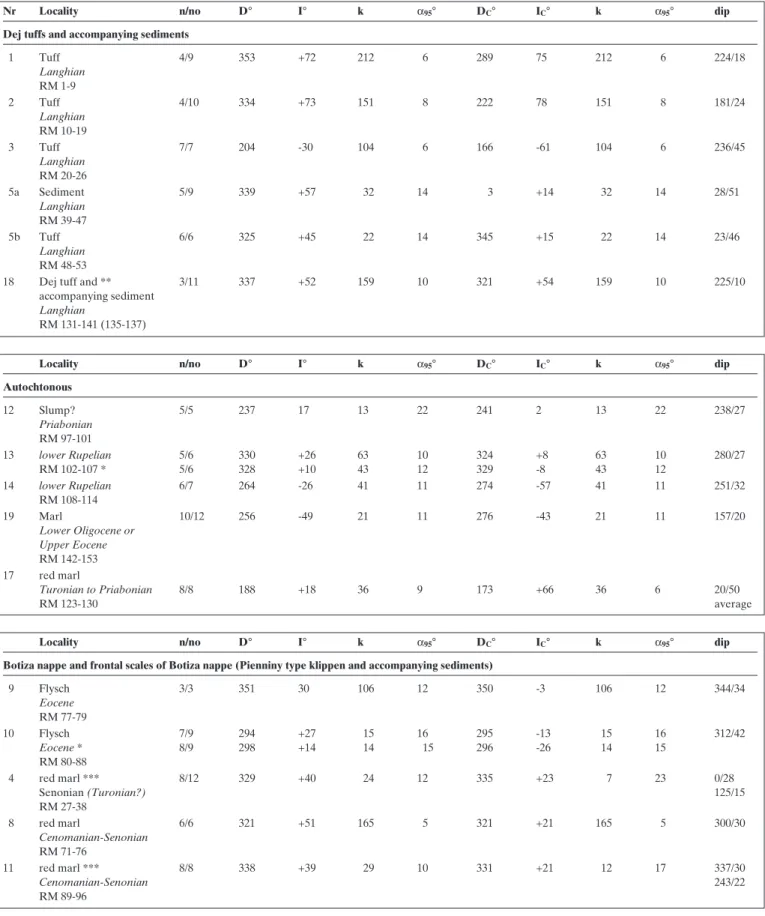
Nr Locality n/no D° I° k α95° DC° IC° k α95° dip Dej tuffs and accompanying sediments
1 Tuff 4/9 353 +72 212 6 289 75 212 6 224/18 Langhian RM 1-9 2 Tuff 4/10 334 +73 151 8 222 78 151 8 181/24 Langhian RM 10-19 3 Tuff 7/7 204 -30 104 6 166 -61 104 6 236/45 Langhian RM 20-26 5a Sediment 5/9 339 +57 32 14 3 +14 32 14 28/51 Langhian RM 39-47 5b Tuff 6/6 325 +45 22 14 345 +15 22 14 23/46 Langhian RM 48-53
18 Dej tuff and ** 3/11 337 +52 159 10 321 +54 159 10 225/10
accompanying sediment
Langhian
RM 131-141 (135-137)
Locality n/no D° I° k α95° DC° IC° k α95° dip
Autochtonous 12 Slump? 5/5 237 17 13 22 241 2 13 22 238/27 Priabonian RM 97-101 13 lower Rupelian 5/6 330 +26 63 10 324 +8 63 10 280/27 RM 102-107 * 5/6 328 +10 43 12 329 -8 43 12 14 lower Rupelian 6/7 264 -26 41 11 274 -57 41 11 251/32 RM 108-114 19 Marl 10/12 256 -49 21 11 276 -43 21 11 157/20 Lower Oligocene or Upper Eocene RM 142-153 17 red marl Turonian to Priabonian 8/8 188 +18 36 9 173 +66 36 6 20/50 RM 123-130 average
Locality n/no D° I° k α95° DC° IC° k α95° dip
Botiza nappe and frontal scales of Botiza nappe (Pienniny type klippen and accompanying sediments)
9 Flysch 3/3 351 30 106 12 350 -3 106 12 344/34 Eocene RM 77-79 10 Flysch 7/9 294 +27 15 16 295 -13 15 16 312/42 Eocene * 8/9 298 +14 14 15 296 -26 14 15 RM 80-88 4 red marl *** 8/12 329 +40 24 12 335 +23 7 23 0/28 Senonian (Turonian?) 125/15 RM 27-38 8 red marl 6/6 321 +51 165 5 321 +21 165 5 300/30 Cenomanian-Senonian RM 71-76 11 red marl *** 8/8 338 +39 29 10 331 +21 12 17 337/30 Cenomanian-Senonian 243/22 RM 89-96
Table 2. Maramures area. Locality mean paleomagnetic directions with statistical parameters. Key: n/no: number of used/collected samples; D°, I° (Dc°, Ic°): declination, inclination before (after) tilt correction; k and α95°: statistical parameters (Fisher 1953). Calculation of directions from least-squares fit of straight line
for sufficiently fine-grained and visibly unaltered sediments led to the abandonment of some of the localities visited without sampling. Samples were taken using a portable drill; the cores were oriented with a magnetic compass. The number of inde-pendently oriented cores at each locality (Table 1) depended on the outcrop conditions in terms of lithology, angle of dip (hence tilt) of the sediments and also on the prospect of ob-taining useful paleomagnetic directions. The lithologies includ-ed dacite tuffite (”Dej tuff”) and accompanying sinclud-ediments (e.g. localities 5 and 8) as well as dark grey (silty) marls and red marls (Couches rouges). The age of the sampled rocks ranges from latest Cretaceous to Langhian (Badenian).
Standard-size specimens were cut from a total of 153 sam-ples drilled at these 19 sites. They were subsequently subjected to paleomagnetic and magnetic susceptibility anisotropy mea-surements at the Paleomagnetic Laboratory of the Eötvös Loránd Geophysical Institute of Hungary.
Laboratory measurements and results
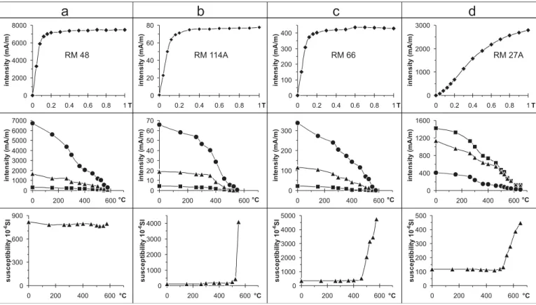
The natural remnant magnetization (NRM) of each specimen was at first measured by using JR-4 and JR-5a spinner magne-tometers. This was followed by the measurement of the anisotropy of magnetic susceptibility (on KLY-2). Sister speci-mens of selected samples were subsequently stepwise demag-netized, by the alternating field (AF) or the thermal method. After each step the remaining NRM was re-measured (also susceptibility in cases where the thermal method was applied). As the NRM was rarely single component, most samples had to be demagnetized in several, sometimes in a large number of steps (Fig. 3).
Demagnetization graphs (examples are shown in Fig. 3) were analysed for linear segments (representing components of the NRM; Kirschvink 1980), and the directions of these seg-ments were used for estimating the mean paleomagnetic direc-tions with statistical parameters (Table 2).
After removing a small viscous component, NRM some-times consisted of a single component (Fig. 3A, 3F); somesome-times two components could be separated (Fig. 3B, 3C, 3D, 3E). Oc-casionally, the direction of the natural remnant magnetization for some samples moved along a great circle without reaching a stable end point (i.e. the components constraining the great circle were not clearly separable). In such cases (localities 10 and 13, see Table 2) the mean paleomagnetic directions for a given locality were determined in three different ways. One was based on linear segments, the second was calculated from the last meaningful demagnetization steps, and the third was based on the combination of stable vectors and remagnetiza-tion circles (McFadden 1990). As Table 2 documents, the three methods provided the same directions (within the error limit). Unstable behaviour, and consequently failure to determine a mean paleomagnetic direction, only concerned locality 15, and partly locality 18 (Lower Langhian = lower Badenian sedi-ments). However, one or more samples from other localities had to be rejected for reasons of instability.
From a statistical point of view, the results compiled in Table 2 are of different quality. Parameters, k and alpha are excellent for localities 1, 2, 3, 8 and 17 (k high and alpha small; Table 2); regarding localities 4, 5, 7, 9, 10, 11, 13, 14, 18 and 19 they are good or acceptable. For localities 6 and 12 the statisti-cal parameters are poor (k lower than 10 or alpha more than 16°; Van der Voo 1993). Nevertheless, the tectonic informa-tion contained in the result for locality 6 is important. When used in combination with the paleomagnetic direction for lo-cality 7 it provides interesting information about the Pienides. Results for localities 16 and 15 are not tabulated, because too few samples are available and because of the instability of NRM.
Magnetic mineralogy experiments (Lowrie 1990) revealed that the mid-Miocene samples and the Eocene–Oligocene sed-iments contain magnetite (Fig. 4 a–c). In the Senonian red marls (Fig. 4d) the magnetic mineral is hard and hematite
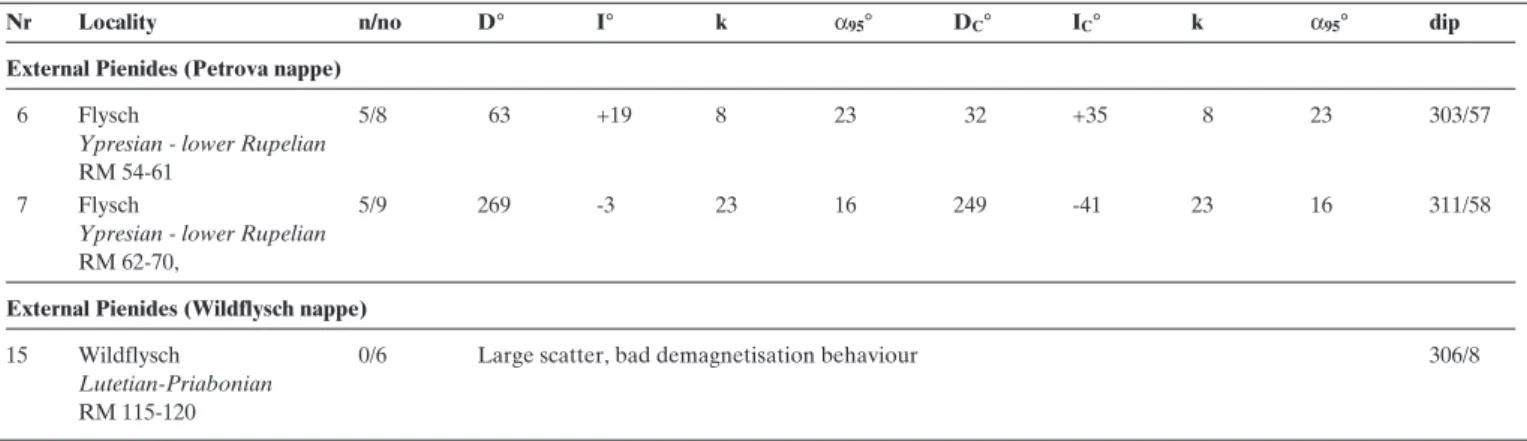
Nr Locality n/no D° I° k α95° DC° IC° k α95° dip
External Pienides (Petrova nappe)
6 Flysch 5/8 63 +19 8 23 32 +35 8 23 303/57
Ypresian - lower Rupelian
RM 54-61
7 Flysch 5/9 269 -3 23 16 249 -41 23 16 311/58
Ypresian - lower Rupelian
RM 62-70,
External Pienides (Wildflysch nappe)
15 Wildflysch 0/6 Large scatter, bad demagnetisation behaviour 306/8
Lutetian-Priabonian
RM 115-120 Table 2. Continue
* directions calculated from end points of demagnetization ** sediments failed
seems to dominate. However, the NRM signal is lost at around 600°C (see Fig. 3E). This suggests that slightly oxidized mag-netite, rather than hematite, is the actual carrier of the rem-nant magnetization.
Measurements of magnetic susceptibility anisotropy showed that the degree of anisotropy (kmax/kmin) is low in
mid-Miocene samples (between 0.8 and 2.4%), with the excep-tion of locality 18 (as high as 10%). In the remaining samples, the degree of anisotropy lies between 4 and 9%, except for those taken from locality 15, which show a surprisingly low (average 1.4%) degree of anisotropy. This is probably due to the dominance of secondary magnetic minerals, an interpre-tation corroborated by the failure to obtain a paleomagnetic direction for this locality.
Magnetic fabric is foliated; foliation poles are close to the bedding poles for sedimentary localities, pointing to a dominantly sedimentary origin of the fabric. Magnetic lin-eation is subordinate (normally less than 1%), yet linlin-eation directions are usually clustered at a given locality (Fig. 5). There is definitely a small imprint by deformation in case of the sediments that pre-date the Dej tuff, since lineation co-incides with the strike of the beds measured in the field. However, a weak lineation suggests weak internal deforma-tion. Consequently, bias of the paleomagnetic vector to-wards the axis of maximum susceptibility (=”magnetic lin-eation”) is highly unlikely. Concerning the foliation, shal-low paleomagnetic inclinations observed for localities 9,10 and 13 (Table 2) are not coupled with a stronger foliation. Therefore inclination shallowing due to compaction is not likely, either.
Fig. 4. Magnetic minerals, identified by acquisition of isothermal remnant magnetization (IRM, top row), stepwise thermal demagnetization of 3-component IRM (Lowrie 1990), acquired successively in fields of 1.0T (squares), 0.36T (triangles) and 0.12T (circles), respectively, and by the behaviour of the magnetic suscepti-bility on heating.
Fig. 5. Directions of magnetic lineations (squares; numbered, according to table 1) and foliation poles (dots) in stereographic projection (tectonic sys-tem). Note that all magnetic lineations, except 12, are practically horizontal.
Discussion of paleomagnetic results
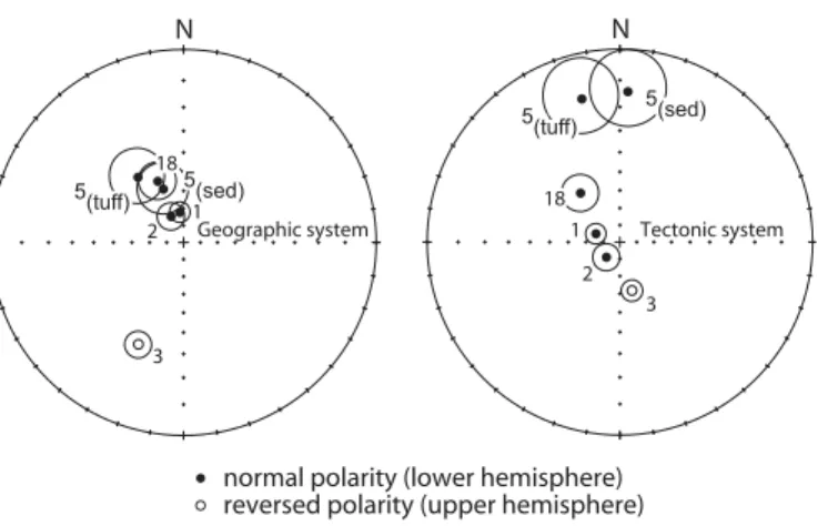
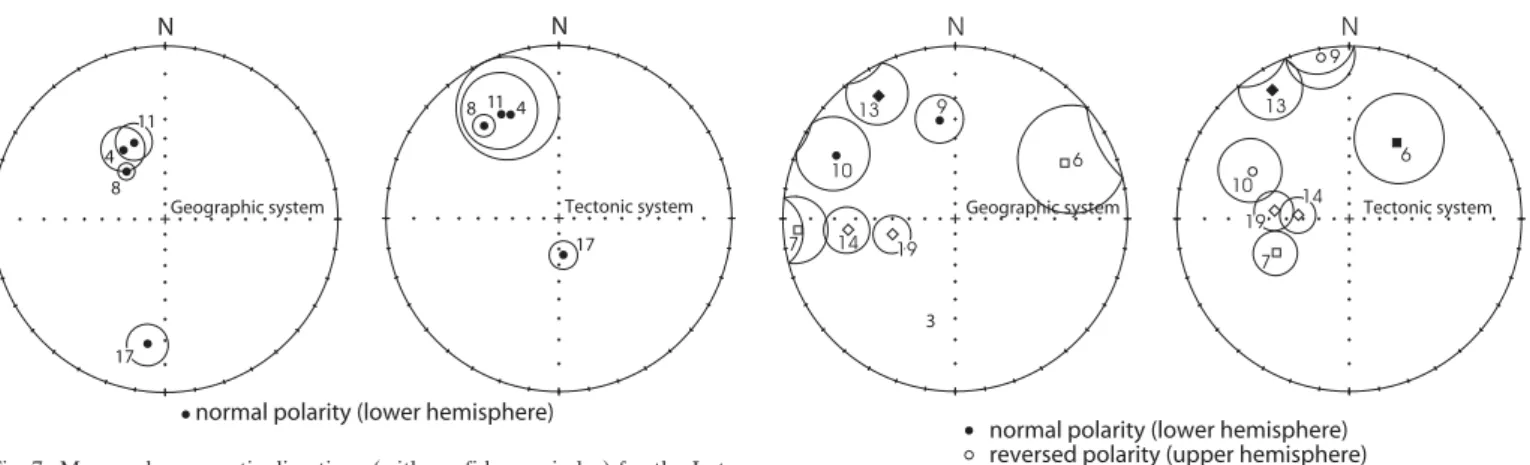
All sampled strata were tilted, occasionally also folded (locali-ties 4 and 11) at the scale of the outcrop. This allowed for fold tests at localities 4 and 11, and for tilt tests on a regional level, thus helping to decide if the paleomagnetic signals were ac-quired before or after folding/tilting. A positive fold test, char-acterised by significantly improved clustering of the paleomag-netic directions after application of tilt corrections, suggests ac-quisition of magnetization before tilting. A negative fold test, with better directional grouping before applying tilt correc-tions, suggests acquisition of magnetization after tilting. For the test only strata or localities of similar age within the same tectonic unit should be considered. In figures 6–8 the plots la-belled “geographic system” and “tectonic system” show direc-tions before and after tilt correcdirec-tions (”fold test”), respective-ly, for the populations of mid-Miocene, Eo-/Oligocene and Late Cretaceous samples.
Mid-Miocene localities: Dej tuff and related sediments
Paleomagnetic directions with normal polarity prevail among the Dej tuff and related sediments. They yield a negative re-sponse to tilt corrections (Fig. 6, Table 3). In our tectonic in-terpretation we will therefore consider the mean paleomagnet-ic direction in a geographpaleomagnet-ic co-ordinate system. If we compare the paleomagnetic direction with reversed polarity (locality 3) to this overall mean direction, we can immediately notice that it has a much shallower inclination in geographic coordinates. However, after tilt correction it moves close to the overall mean direction for the normal polarity group (in antipodal po-sition), the latter still in a geographical co-ordinate system. As the improvement in clustering is basically due to a dramatic improvement in the degree of consistency of inclinations, we interpret the paleomagnetic direction for locality 3 to pre-date tilting (Fig. 6). This interpretation implies that number 3 is the only site amongst the Dej tuffs, which preserved the paleomag-netic signal acquired before the tilting event. The overall mean paleomagnetic direction determined this way (Table 3, number
3) departs by some 30° from present-day north in a counter-clockwise sense (Fig. 6). It is interesting that locality 18, which is situated south of the Bogdan- Dragos-Voda fault system, also exhibits counter clockwise rotation. This poses a problem in the context of the earlier postulated repeated clockwise ro-tation of the Tisza-Dacia mega-tectonic unit (Panaiotu 1999); but we have to keep in mind that this result is based on only three samples. Due to the small number of samples, this direc-tion should only be taken into account as an indicadirec-tion, rather than firm evidence, in a tectonic interpretation.
Late Cretaceous localities: red marls
Three out of four Late Cretaceous localities yield good results and are located in allochthonous units (locality 4 at the base of the Botiza nappe; localities 8 and 11 in the Pieniny type klip-pen and associated flysch). Locality 17 is in the parautochtho-nous cover of the Tisza-Dacia mega-tectonic unit. At localities
Fig. 6. Mean paleomagnetic directions (with confidence circles) for the mid-Miocene localities. Left: no tilt correction applied; right: tilt correction applied. Tilt test is negative for localities 1, 2, 5 and 18 (Table 3), while the mean direc-tion of locality 3 moves towards the rest (with opposite polarity) of the locali-ties after tilt correction.
N D° I° k α95° DC° IC° k α95° remark
1 Dej tuffs and accompanying sediments 5 336 +60 38 13 337 +53 4 41 present paper
localities: 1, 2, 5a, 5b, 18 max: -10%
2 Dej tuffs and accompanying sediments 6 348 +57 15 18 339 +54 5 32 present paper
localities: 1, 2, 5a, 5b, 18 and 3 max: +20%
3 Dej tuffs and accompanying sediments 6 337 +60 46 10 - - - - present paper localities: 1, 2, 5a, 5b, 18 before tilt
correction and 3 after tilt correction
4 Cenomanian-Senonian red marls 3 330 +43 81 14 - - - - present paper localities: 4, 8, 11
5 Eo/Oligocene autochthonous 4 259 -42 37 15 269 -44 60 12 present paper +
localities: 14, 19 and Panaiotu RONAP, DS Panaiotu 1999
max: +60%
6 Eo/Oligocene localities 6,7 2 256 -11 - - 230 -40 - - present paper Table 3. Overall mean paleomagnetic directions constraining the Tertiary rotations of the Maramures area. Key as for Table II, and N is the number of localities.
4 and 11 samples were drilled from strata with variable tilts. Within-locality fold tests for these localities yielded negative results (Table 2), which indicates re-magnetization. Since the direction of locality 8 groups well with those of 4 and 11 (Fig. 7), it is also considered as remagnetized. The most likely expla-nation for remagnetization after folding is that the red marls originally contained goethite, which became dehydrated and converted into a hematite-like mineral, perhaps under the influence of Neogene volcanism because their paleomagnetic directions show a remarkable similarity to the paleomagnetic directions obtained for the mid-Miocene localities and depart from paleomagnetic directions expected for Cretaceous (Besse and Courtillot 2002).
Locality 17 has excellent paleomagnetic properties, but ap-pears as an outlier, both when plotted in the geographic as well as in the tectonic co-ordinate system, respectively (Fig. 7). Being collected from the parautochthonous cover of Tisza-Dacia, its unexpected direction is difficult to interpret in terms of tectonics. Quite possibly these strata were also influenced by gravitational movements which were evident nearby but not within the sampled outcrop.
Eo- to Oligocene localities: flysch samples
Seven localities plotted in Figure 8 yielded statistically good or acceptable paleomagnetic directions (see Table 2). Three of them (localities 14, 19 and 13) belong to the autochthonous-parautochthonous cover of the Tisza-Dacia mega-tectonic unit. Localities 14 and 19 in both geographic and tectonic co-ordi-nate systems indicate about 90° clockwise rotation with respect to present north (and also to expected directions for Eocene-Oligocene, Besse & Courtillot 2002), while inclinations are consistent and moderately steep. Locality 13 yields extremely low inclination values, both before and after tilt correction. We suspect that the apparently good magnetic signal still is a com-posite one, and must be disregarded in tectonic interpretation.
Localities 6, 7 are from the allochthonous external Pienides (Leordina nappe). The mean directions have very shallow in-clinations before tilt correction, while after tilt correction (tec-tonic system in Fig. 8), the mean directions become roughly antipodal and inclinations become similar to those obtained for localities 14 and 19 from the autochthonous. We consider these directions as original, pre-folding magnetizations, show-ing marked clockwise rotation.
Localities 9 and 10 are from the internal Botiza nappe. Pa-leomagnetic directions obtained for them are far apart from each other in both co-ordinate systems; inclinations are too shallow in order to represent Paleogene or younger inclina-tions. Therefore we do not consider them in our tectonic inter-pretation.
In summary, out of seven tabulated mean paleomagnetic directions for the Eo-Oligocene, four localities are suitable for an interpretation in terms of regional tectonics: two from the autochthon and two from the Leordina nappe. They have consistent inclinations and all of them exhibit a clockwise de-viation of the declination with respect to present-day north. There is, however, a difference in declination between the autochthon and the Leordina nappe, as will be discussed below.
Discussion and tectonic interpretation of the results
Re-magnetization of the Cretaceous localities led to paleo-magnetic directions, which are remarkably similar to those ob-tained for the mid-Miocene localities. Hence, these two data sets will be discussed together to make inferences about post mid-Miocene counter-clockwise rotations. In a second step we discuss clockwise rotations indicated by the data obtained from the Eo- Oligocene formations.
Fig. 7. Mean paleomagnetic directions (with confidence circles) for the Late Cretaceous localities. Note that the data obtained for localities 4 and 11 fail the within-locality fold test (Table 2) and thus indicate remagnetization (prob-ably) during mid-Miocene times.
Fig. 8. Mean paleomagnetic directions for the Eo-Oligocene localities (au-tochthon: diamond; Leordina nappe: squares; Botiza nappe: circles). Note that the fold test improves the grouping for 6 (normal polarity), 7, 14, 19 (reversed polarities), and that the paleomagnetic direction for locality 10 moves closer to the cluster after tilt correction.
Inferences regarding post-12 Ma counter-clockwise rotations (mid-Miocene and Late Cretaceous localities)
The mid-Miocene localities (with the exception of locality 3) and the Late Cretaceous localities carry secondary paleo-magnetic signals departing from the direction of the present-day earth magnetic field in the sampling area (Fig. 9). The de-flection indicates counter-clockwise rotations of about 30° (Table 3). This rotation must have taken place later than 12 Ma ago, since the negative fold/tilt tests indicate that their
characteristic remnant magnetism was acquired after folding, which ended 12 Ma ago (Tischler et al. 2007). A similar rotation was suggested for the Sarmatian (13–11.6 Ma) mem-bers of the volcanic body of Baia Mare (Pa˘tra˘scu 1993), while the Late Miocene (Pannonian, post-11.6 Ma) members in the same body remained unaffected by this rotation. Thus, the counter-clockwise rotation observed for the Dej tuff and or the Late Cretaceous localities must have occurred immediately after tilting and magnetization, i.e. about 12 Ma ago. Note that this rotation involved the cover of the Tisza-Dacia
mega-tec-Fig. 9. Paleo-declinations, plotted relative to present-day north on a geological map. The secondary magnetizations of mid-Miocene and Late Cretaceous locali-ties indicate a post-12 Ma (see text) counter clockwise rotation of about 30° (white arrows). The Eo-Oligocene locations show consistent clockwise rotations that pre-date the counter clockwise rotations (black arrows; see discussion in text).
tonic unit north, (and possibly south, as our locality 18 sug-gests) of the Bogdan-Dragos Voda fault (Fig. 9), as well as the Pienides, which were originally part of ALCAPA.
Sense, magnitude and timing of these post-12 Ma rotations in the study area are similar to rotations inferred for the East Slovak Basin (Orlick˘ 1996, Márton et al. 2000), for the Vi-horlat Mts (Túnyi et al. 2005) and for the Tokaj area (Márton 2001). Therefore, we think that the East Slovak basin and our working area (Fig. 10) behaved as a single tectonic unit after some 12 Ma ago.
Rotations, however, are different in those parts of the ALCAPA mega-tectonic unit, which are located west of the Hernád-fault (Central W-Carpathians, see Fig. 10), where counter clockwise rotation stopped earlier, at around 14.5 Ma (Márton 2001). This different timing of rotations west and east of the Hernád fault calls for a tectonic separation across this fault.
The onset of the post-12 Ma counterclockwise rotations in the study area coincides with a significant change of the
tec-tonic setting. According to Tischler et al. (2007) sinistral trans-pression (16–12 Ma) changed to sinistral transtension (12–10 Ma), concentrating along the Bogdan-Dragos Voda fault sys-tem. This transition is probably due to soft collision of ALCA-PA, including the northern parts of the Tisza-Dacia mega-tec-tonic unit with the European foreland (Tischler et al. 2007). Convergence continued however further south, i.e. in the East Carpathians (Matenco et al. 2003). The clockwise rotation doc-umented for the 14.2–11 Ma time interval (Panaiotu 1998, 1999), which affected the southern Apuseni Mountains (which are part of Tisza) can also be connected to this event.
Inferences regarding pre-12 Ma clockwise rotations (Eo-/Oligocene localities)
Those four Eo-/Oligocene localities from the study area, which we consider in our tectonic interpretation, exhibit substantial clockwise deflections of paleo-declinations (Fig. 9, Table 3),
Fig. 10. Geological sketch map of the triple junction between ALCAPA, Tisza-Dacia and the European foreland. Map redrawn after Fig. 1, Kováãet al. (1995) and Sa˘ndulescu et al. (1978). The Hernád fault is interpreted as providing the detachment of the counter clockwise rotating domain of ALCAPA (Inner West Carpathians) and the Transcarpathian depression. The fault pattern of the corresponding eastern detachment fault, between the Transcarpathian depression and the clockwise rotating Tisza-Dacia (including the eastern tip of ALCAPA), follows structures taken from the subcrop map of Sa˘ndulescu et al. (1993).
He rna dfa ult Bükk Mts Mts Bükk Mts Presov-T okaj Presov-T okaj Mts Mts Inner Inner West West Carpathians Carpathians Pieniny Klippe
n
belt
Pieniny Klippe
n belt Vi horlat Mts Vi horlat Mts European foreland
Miocene thrust belt
B DF B DF
MHFZ
Transcarpathian depression Carpathian foredeep ESB Presov-T okaj Mts Inner West Carpathians100 km
N
Neogene Volcanics
ALCAPA
Bükk Mts.
Bükk Mts.
Tisza-Dacia
Biharia unit
Ceahlau and
Black Flysch nappes
Magura unit and
external Pienides
Pieniny Klippen and
Internal Pienides
Inner West Carpathians
Autochthonous cover
Bucovinian nappes
Neogene Basins
Legend
ESB: East Slovak Basin
BDF: Bogdan-Dragos Voda fault
MHFZ: Mid-Hungarian fault zone
suggesting clockwise rotations which pre-date the counter-clockwise rotations discussed above. Due to the subsequent counter clockwise rotation, the clockwise rotations suggested by the paleo-declinations in Fig. 9, and discussed below, repre-sent an under-estimate by some 30°.
The observed pre-12 Ma clockwise rotations for the au-tochthon (localities 14 and 19) are in line with earlier paleo-magnetic results from the Tisza-Dacia mega-tectonic unit (Panaiotu 1998). However, clockwise rotations are unexpected for the Pienides. These are considered as part of the ALCAPA unit, which is known to have suffered counter-clockwise rota-tions during the Miocene (e.g. Bükk Mts.: Márton & Fodor 1995; Gemer region: Márton et al. 1988; Inner West Carpathi-an flysch basin: Márton et al. 1999).
The following is an important starting point for recon-structing the main rotational events in the Maramures area: localities 14 and 19 of the present study from the (para-) autochthonous sedimentary cover of the Tisza-Dacia mega-tectonic unit, when combined with two earlier published re-sults of the same age from the autochthon (Panaiotu 1998), define a rotation for the autochthon which has good statistical parameters (Table 3). The timing of this rotation is not well constrained, except that it must post-date the Eo-Oligocene ages of deposition of the analysed sediments. Compared to this ”reference” direction, localities 6 and 7 from the Pienides (i.e. the easternmost tip of ALCAPA) show less clockwise rotation. This situation suggests that the Pienides and Tisza-Dacia rotat-ed, at least partly, in a different manner and/or at different times.
According to our interpretation Tisza-Dacia started to ro-tate clockwise before emplacement of the Pienides at around 18.5 Ma. This is supported by independent observations. Ac-cording to Fügenschuh and Schmid (2005) a substantial clock-wise rotation of the Tisza –Dacia mega-tectonic unit predates 18.5 Ma. Also the change in strike of the foredeep (from E-W to SE-NW in Late Oligocene times towards ENE-WSW in Early Miocene times; De Broucker et al. 1998; Györfi et al. 1999) suggests clockwise rotation. Since ongoing clockwise ro-tation affected the Pienides only after emplacement onto and their mechanical coupling with Tisza-Dacia, a smaller angle of rotation is expected for the Pienides.
An alternative to the above interpretation would be that the smaller clockwise rotation of the Pienides resulted from a previous counter-clockwise rotation of the Pienides by about 45°, predating a 90° clockwise rotation (together with the Tisza-Dacia mega-tectonic unit). This possibility is considered, since the Pienides represent the eastern tip of the ALCAPA mega-tectonic unit, which is characterized by counter clock-wise rotated Miocene declinations (e.g. Márton 1987; Balla 1987). Fortunately, a paleomagnetic study (Márton & Márton 1996) followed by integrated paleomagnetic measurements and K/Ar isotope age determination (Márton & Pécskay 1998) provided precise time constraints for the rotations of the area W of the Hernád fault. These studies suggest that no Tertiary rotation occurred before 18.5 Ma. The first counter clockwise
rotation took place in the 18.5–17.5 Ma time interval, the sec-ond from 16 to 14.5 Ma. As both rotation events post-date thrusting of the Pienides, this second alternative interpretation is far less probable compared to the first one.
Disintegration of the ALCAPA mega-tectonic unit starting at 18.5 Ma ago
Our results, in the context of previously published paleomag-netic data, clearly imply that the ALCAPA mega-tectonic unit started to disintegrate during the Miocene. This process start-ed with the decoupling of its northeastern-most tip (Pienides) from the rest of ALCAPA. The decoupling must have oc-curred somewhere within the Transcarpathian depression (Fig. 10), which is an intervening area that strongly subsided since the Middle Miocene, due to transtension (i.e. Kováã et al. 1994). A window of lower structural units (Ináãovce Krichevo unit) in the basement of the East Slovak basin (Soták et al. 1993, 1994) has been interpreted as a metamorphic core (Soták et al. 2000).
We therefore propose that the Transcarpathian depression is the site of major extension. This major NW-SE extension can also be seen in some Slovak seismic lines and is evidenced by thick deposits, tilted beds, syn-rift style geometry and fault offsets (Santavy & Vozár 1999) which occurred between 17.5 Ma and 11 Ma ago. Major Neogene extension is evident also in our study area. Immediately NW of the internal Pienides a deep Miocene basin (the SE edge of the Transcarpathian de-pression) is found, featuring thick Langhian (Badenian) salt deposits. Large amounts of buried Middle-Late Miocene vol-canites in the area of the Transcarpathian depression (Fig. 10) also suggest major extension.
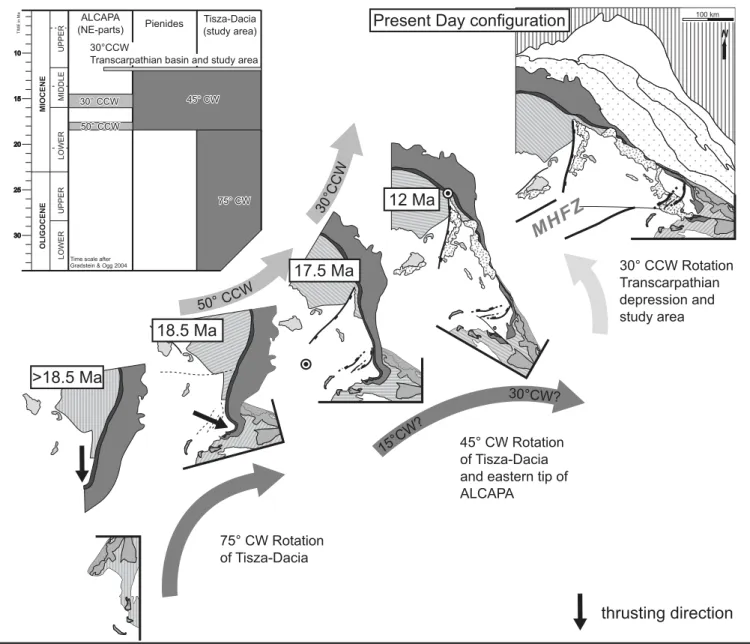
Tentative model for the tectonic evolution
Data and considerations discussed in the previous part of this chapter lead to the following model. The easternmost tip of the ALCAPA mega-tectonic unit (Pienides) was emplaced onto the Tisza-Dacia mega-tectonic unit along the Pienide thrust front between 20.5 Ma and 18.5 Ma. Before this thrust-ing, Tisza-Dacia underwent some 45° out of its bulk clockwise rotation (Fig. 11). After 18.5 Ma both the Pienides and Tisza-Dacia underwent a common clockwise rotation of some 45° (75° if the subsequent counter clockwise rotation is also taken into account), while the rest of the ALCAPA mega-tectonic unit followed a pattern of counter-clockwise rotations (Fig. 11b).
This led to the disintegration of ALCAPA, and the decou-pling of its easternmost tip (the Pienides), which was previous-ly fixed to Tisza-Dacia. Differential stretching took place across the N-S to NE-SW trending normal faults within the Transcarpathian depression (Fig. 10). One of these, the Hernád fault, accounts for decoupling and clockwise rotation of the tip of ALCAPA from the bulk of this mega-tectonic unit. Hence major NW-SE rotational stretching within the
Transcarpathian depression, and the East Slovak basin in par-ticular, was driven by differential rotations of the main body of ALCAPA in respect to the thrust tip of ALCAPA (Fig. 11). The pole for this rotation is suggested to be located some-where near the southern termination of the Hernád fault. This implies that the northern rim of the Transcarpathian depres-sion should be stretched and bordered by transfer type faults, as is suggested by the thinning and the NW-SE elongation of the belt of external Carpathian Flysch units.
At around 12–11.5 Ma, when transpression along the Bogdan-Dragos Voda fault system changed to transtension (Tischler et al. 2007), a second differential rotation and
decoupling from the main body of ALCAPA occurred at or near the Hernád fault. Syn-rift type Sarmatian beds corrobo-rate this interpretation. The observed 30° counter clockwise rotation in the study area, as well as in the Transcarpathian depression, is modelled as ”en block” rotation around a pole at the northern tip of the Hernád fault in Figure 11. An alter-native explanation for the observed 30° counter clockwise ro-tation could be the roro-tation of smaller, strike slip fault bound blocks in a deformation corridor. Such a rotation would also imply a stretched southern margin, where large subsidence and thick buried Miocene volcanites do occur (Széky-Fux & Pécs-kay 1991).
Conclusions
During a main rotational stage, i.e. between 18.5–12 Ma, large clockwise rotations of at least 45° did occur in the study area. These affected the (par-) autochthonous sedimentary cover of the Tisza-Dacia mega-tectonic unit, as well as the allochtho-nous flysch nappes of the Pienides, representing the eastern-most tip of the ALCAPA mega-tectonic unit. Since the Pienides originally belonged to ALCAPA, and because the main body of ALCAPA rotated counter clockwise, our new results from the Maramures area necessitate the disintegration of ALCAPA at around 18.5 Ma ago. The site of disintegration has to be looked for within the Transcarpathian depression (East Slovak basin in particular), located in the NE prolonga-tion of the Mid-Hungarian fault zone, where numerous nor-mal faults account for differential stretching (Fig.10). The opening of the Transcarpathian depression was accompanied by the sedimentation of mid-Miocene and younger sediments of great thickness.
During a second stage, immediately after 12 Ma, counter-clockwise rotations of about 30° are documented in the entire working area. These counter-clockwise rotations are similar in timing and magnitude to rotations observed for the East Slo-vak basin, for the Tokaj Mts and for the Vihorlat Mts., i.e. areas that are part of the Transcarpathian depression. Howev-er, counter-clockwise rotations stopped after 14.5 Ma west of the Hernád-fault, i.e. in the W-Carpathians, as well as in the Bükk Mountains. Hence this second decoupling of the Central W-Carpathians from the Transcarpathian depression occurred along the Hernád fault.
Acknowledgements
We thank Mircea Sa˘ndulescu for introducing two of us (S. Sch, B. F.) into the exciting geology of the Maramures area. We gratefully acknowledge Heike Gröger for useful ideas and permanent support, as well as Gábor Imre for technical assistance in the field and the lab. Comments by Cristian Panaiotu and an anonymous reviewer helped to improve the paper. The present project was granted by NSF 200020-105136/1 (“The Dragos-Voda fault in northern Romania: the eastern termination of the Mid-Hungarian Line fault system ?”) and NSF200021-101882/1 (”Tisza and its role in the framework of the tectonic evolution of Alps, Dinarides and Carpathians”) granted to B. F. and S. Sch., respectively.
REFERENCES
Aroldi, C. 2001: The Pienides in Maramures – Sedimentation, tectonics and paleogeography. PhD thesis Cluj (Romania), 156 pp.
Balla, Z. 1984: The Carpathian loop and the Pannonian basin: a kinematic analysis. Geophysical Transactions 30, 313–353.
Balla, Z. 1987: Cenozoic paleomagnetic data for the Carpatho-Pannonian re-gion in the light of Miocene rotation kinematics. Tectonophysics 139, 67–98.
Besse, J. & Courtillot, V. 2002: Apparent and true polar wander and the geom-etry of the geomagnetic field over the last 200 Myr. Journal of Geophysi-cal Research B: Solid Earth 107, 6–31.
Ciulavu, D. 1999: Tertiary tectonics of the Transylvanian Basin. PhD thesis Vrije Universiteit Amsterdam, 154 pp.
Ciulavu, D., Dinu, C. & Cloetingh, S.A.P.L. 2002: Late Cenozoic tectonic evo-lution of the Transylvanian basin and northeastern part of the Pannonian basin (Romania): Constraints from seismic profiling and numerical mod-elling. EGU Stephan Mueller Special Publication 3, 105–120.
Csontos, L. 1995: Cenozoic tectonic evolution of the Intra-Carpathian area: a review. Acta Vulcanologica 7, 1–13.
Csontos, L. & Nagymarosy, A. 1998: The Mid-Hungarian line: a zone of re-peated tectonic inversions. Tectonophysics 297, 51–71.
Csontos, L. & Vörös, A. 2004: Mesozoic plate tectonic reconstruction of the Carpathian region. Paleogeography, Paleoclimatology, Paleoecology 210, 1–56.
Csontos, L., Márton, E., Wórum, G. & Benkovics, L. 2002: Geodynamics of SW-Pannonian inselbergs (Mecsek and Villány Mts, SW Hungary). EGU Stephan Mueller Special Publication 3, 227–245.
De Broucker, G., Mellin, A. & Duindam, P. 1998: Tectonostratigraphic evolu-tion of the Transylvanian Basin, Pre-Salt sequence, Romania, In: Dinu, C. (ed.): BGF Special volume 1, 36–70.
Dicea, O., Dutescu, P., Antonescu, F., Mitrea, G., Botez, R., Donos, I., Lungu, V. & Morosanu, I. 1980: Contributii la cunoasterea tectonicii zonei tran-scarpatice din Maramures. D. S. Inst. geol. geofiz. LXV(5), 35–53. Fisher, R. 1953: Dispersion on a sphere. Proceedings Royal Societies London
Series A. 217, 295–305.
Fodor, L., Jelen, B., Márton, E., Skaberne, D., Car, J. & Vrabec, M. 1998: Miocene-Pliocene evolution of the Slovenian Periadriatic fault: Implica-tions for Alpine Carpathian extrusion models. Tectonics 17, 690–709. Fodor, L., Csontos, L., Bada, G., Györfi, I. & Benkovics, L. 1999: Cenozoic
tectonic evolution of the Pannonian basin system and neighbouring oro-gens: a new synthesis of paleostress data. In: Durand, B., Jolivet, L., Horváth, F. & Séranne, M. (eds.): The Mediterranean basins: Cenozoic Extension within the Alpine Orogen. Geological Society Special Publica-tion 156, 295–334.
Fügenschuh, B. & Schmid, S.M. 2005: Age and significance of core complex formation in a very curved orogen: Evidence from fission track studies in the South Carpathians (Romania). Tectonophysics 404, 33–53.
Gradstein, F., Ogg, J. & Smith, A. 2004: A Geologic Time Scale. Cambridge University Press, Cambridge, 589 pp.
Györfi, I., Csontos, L. & Nagymarosy, A., 1999: Early Cenozoic structural evo-lution of the border zone between the Pannonian and Transylvanian basins. In: Durand, B., Jolivet, L., Horváth, F. & Séranne, M. (eds.): The Mediterranean Basins: Cenozoic Extension within the Alpine Orogen. Geological Societies Special Publications 156, 251– 267.
Horváth, F., Bada, G., Szafián, P., Tari, G., Ádám, A. & Cloetingh, S. 2006: Formation and deformation of the Pannonian basin: constraints from ob-servational data. Geological Societies London. Mémoirs 32, 191–206. Huismans, R.S., Bertotti, G., Sanders, C., Ciulavu, D., Cloetingh, S.A.P.L. &
Dinu, C. 1997: The structural evolution of the Transylvanian basin, a sed-imentary basin in a bend zone of the Carpathians. Tectonophysics 272, 249–268.
Kirschvink, J.L. 1980: The least-squares line and plane and the analysis of pa-leomagnetic data. Geophysical Journal of the Royal Astronomical Society 62, 699–718.
Kováã, M., Král’, J., Márton, E., Pla‰ienka, D. & Uher, P. 1994: Alpine uplift history of the Central West Carpathians: geochronological, paleomag-netic, sedimentary and structural data. Geologica Carpathica 45, 83–96. Kováã, M., Kováã, P., Marko, F., Karoli, S., Janoãko, J. 1995: The East
Slova-kian Basin – a complex back arc basin. Tectonophysics 252, 453–466. Lowrie, W. 1990: Identification of ferromagnetic minerals in a rock by
coerciv-ity and unblocking temperature properties. Geophysical Research Letters 17, 159–162.
Márton, E. 1987: Paleomagnetism and tectonics in the Mediterranean region. Journal of Geodynamics 7, 33–57.
Márton, E. 2000: The Tisza Megatectonic Unit in the light of paleomagnetic data. Acta Geologica Hungarica 43, 329– 343.
Márton, E. 2001: Tectonic implications of Tertiary paleomagnetic results from the PANCARDI area (Hungarian contribution). Acta Geologica Hun-garica 44, 135–144.
Márton, E. & Fodor, L. 1995: Combination of palaeomagnetic and stress data – a case study from North Hungary. Tectonophysics 242, 99–114.
Márton, E. & Fodor, L. 2003: Tertiary paleomagnetic results and structural analysis from the Transdanubian Range (Hungary): rotational disintegra-tion of the ALCAPA unit. Tectonophysics 363, 201–224.
Márton, E. & Márton, P. 1978: On the difference between the palaeomagnetic poles from the Transdanubian Central Mountains and the Villány Moun-tains respectively (in Hungarian). Magyar Geofizika XIX/4, 129–136. Márton, E. & Márton, P. 1996: Large scale rotations in North Hungary during
the Neogene as indicated by palaeomagnetic data. In: Morris, A. & Tar-ling, D.H. (eds.): Palaeomagnetism and Tectonics of the Mediterranean Region. Geol. Soc. Spec. Publication 105, 153–173.
Márton, E. & Pécskay, Z. 1998: Correlation and dating of the ignimbritic volcanics in the Bükk foreland, Hungary: complex evaluation of paleo-magnetic and K/Ar isotope data. Acta Geologica Hungarica 41, 467–476. Márton, E., Márton, P. & Less, Gy. 1988: Paleomagnetic evidence of tectonic rotations in the Southern margin of the Inner West Carpathians. Physics Earth and Planetary Interiors 52, 256–266.
Márton, E., Mastella, L. & Tokarski, A.K. 1999: Large counterclockwise rota-tion of the Inner West Carpathian Paleogene Flysch – evidence from paleomagnetic investigation of the Podhale Flysch (Poland). Physics and Chemistry of the Earth 24, 645–649.
Márton, E., Vass, D. & Tunyi, I. 2000: Counterclockwise rotations of the Neogene rocks in the East Slovak basin. Geologica Carpathica 51, 159–168.
Mat¸enco, L., Bertotti, G., Cloetingh, S. & Dinu, C. 2003: Subsidence analysis and tectonic evolution of the external Carpathian-Moesian Platform dur-ing Neogene times. Sedimentary Geology 156, 71–94.
McFadden, P. L., 1990: A new fold test for palaeomagnetic studies. Geophysi-cal Journal International 103, 163–169.
Orlick˘, O. 1996: Paleomagnetism of neovolcanics of the East-Slovak Low-lands and Zemplínske Vrchy Mts: A study of the tectonics applying the paleomagnetic data (Western Carpathians). Geologica Carpathica 47, 12–20.
Panaiotu, C. 1998: Paleomagnetic constraints on the geodynamic history of Romania. In: Ioane, D. (ed.): Monograph of Southern Carpathians. Re-ports on Geodesy 7, 205–216.
Panaiotu, C. 1999: Paleomagnetic studies in Romania; Tectonophysics impli-cations (in Romanian). PhD thesis University of Bucharest, 265 pp. Pa˘tra˘scu, S. 1993: Paleomagnetic study of some Neogene magmatic rocks from
the Oas – Ignis – Varatec – Tibles Mountains (Romania). Geophysical Journal International 113, 215–224.
Pécskay, Z., Edelstein, O., Kovacs, M., Bernád, A. & Crihan, M. 1994: K/Ar age determination of Neogene volcanic rocks from the Gutai Mts. (East-ern Carpathians, Romania). Geologica Carpathica 45, 357–363. Popescu, B.M. 1984: Lithostratigraphy of cyclic continental to marine Eocene
deposits in NW Transylvania, Romania. In: Popescu, B.M. (ed.): The Transylvanian Paleogene Basin, Geneva, 37–73.
Ratschbacher, L., Merle, O., Davy, P. & Cobbold, P. 1991a: Lateral extrusion in the Eastern Alps; Part 1, Boundary conditions and experiments scaled for gravity. Tectonics 10, 245– 256.
Ratschbacher, L., Frisch, W., Linzer, H.G. & Merle, O., 1991b: Lateral extru-sion in the Eastern Alps; Part 2, Structural analysis. Tectonics 10, 257– 271.
Ratschbacher, L., Linzer, H.G. & Moser, F. 1993: Cretaceous to Miocene thrusting and wrenching along the Central South Carpathians due to a corner effect during collision and orocline formation. Tectonics 12, 855–873.
Royden, L.H. 1988: Late Cenozoic Tectonics of the Pannonian Basin System In: Royden L.H. & Horvath F. (eds.): The Pannonian Basin; a study in basin evolution. AAPG Memoir 45, 27–48.
Sa˘ndulescu, M. 1980: Sur certains problèmes de la corrélation des Carpathes orientales Roumaines avec les Carpathes Ucrainiennes. D. S. Inst. geol. geofiz. LXV, Tectonica si geologie Regionala (1977–1978), 163–180.
Sa˘ndulescu, M. 1984: Geotectonica Romaniei. Editura Tehnica, Bucuresti, 336 pp.
Sa˘ndulescu, M. 1994: Overview on Romanian Geology. 2. Alcapa Congress, Field guidebook, Rom. Journal of Tectonics and Regional Geology 75, 3–15.
Sa˘ndulescu, M., Kräutner, H., Borcos, M., Na˘sta˘seanu, S., Patrulius, D., Stefa˘nescu, M., Ghenea, C., Lupu, M., Savu, H., Bercia, I. & Marinescu, F. 1978: Geological map of Romania 1:1.000.000. Inst. Geol. Rom., Bucharest.
Sa˘ndulescu, M., Kräutner, H.G., Balintoni, I., Russo- Sa˘ndulescu, D. & Micu, M. 1981: The Structure of the East Carpathians. Guide Book B1, 12th Congress Carpatho-Balkan Geological Association, Bucharest, 92 pp. Sa˘ndulescu, M., Visarion, M., Stanica, D., Stanica, M. & Atanasiu, L. 1993:
Deep Structure of the inner Carpathians in the Maramures-Tisa zone (East Carpathians). Rom. J. Geophysics 16, 67–76.
Santavy, & Vozár, J. 1999: Electronical Atlas of Deep Reflection Seismic Profiles of the Western Carpathians. CD ROM, GUDS Bratislava ISBN 80-88974-06-2.
Schmid, S.M., Berza, T., Diaconescu, V., Froitzheim, N. & Fügenschuh, B. 1998: Orogen-parallel extension in the South Carpathians. Tectonophysics 297, 209–228.
Soták, J., Rudinec, R. & Spi‰iak, J. 1993: The Penninic “pull-apart” dome in the pre-Neogene basement of the Transcarpathian depression (Eastern Slovakia). Geologica Carpathica 44/1, 11–16.
Soták, J., Spi‰iak, J. & Biron, A. 1994: Metamorphic sequences with Bündner-schiefer lithology in the pre-Neogene basement of the East Slovakian Basin. Mitteilungen Österreichische Geologische Gesellschaft 86, 111–120. Soták, J., Biron, A., Prokesova, R. & Spi‰iak, J. 2000: Detachment control of core complex exhumation and back-arc extension in the East Slovakian Basin. In: Kováç, M., Vozár, J., Vozárová, A., Michalik, J. (eds.): Envi-ronmental, structural and stratigraphical evolution of the Western Carpathians. Slovak Geological Magazine (Geological Survey of Slovak Republic. Bratislava, Slovak Republic) 6, 130–132.
Sperner, B. Ratschbacher, L. & Nemcok, M. 2002: Interplay between subduc-tion retreat and lateral extrusion: tectonics of the Western Carpathians. Tectonics 21/6, I-1 to I–24, 1051, doi:10.1029/2001TC901028.
Szakács, A., Vlad, D., Andriessen, P.A.M., Fülöp, A. & Pécskay, Z. 2000: Eruption of the “Dej tuff”, Transylvanian Basin: when, where and how many. Vijesti Hrvatskoga geolo‰kog dru‰tva, PANCARDI 2000-Special Issue, Abstract volume 37, 122.
Széky-Fux, V. & Pécskay, Z 1991: Covered Neogene volcanic rocks at the east-ern and northeast-ern areas of the Pannonian basin, Hungary. In: Karamata, S. (eds.): Geodynamic evolution of the Pannonian basin. Serb. Acad. Sci. Arts, Acad. Conf. 62, Dept. Nat. Math. Sci. 4, Belgrade: 275–287. Tischler, M., Gröger, H.R., Fügenschuh, B. & Schmid, S.M. 2007: Miocene
tectonics of the Maramures area (Northern Romania) – implications for the Mid-Hungarian fault zone. International Journal of Earth Sciences. DOI 10.1007/s00531 006–0110-x
Túnyi, I., Márton, E., Îec, B. & Vass, D. 2005: Paleomagnetism of Neovol-canics of the Vihorlatské vrchy Mts. Mineralia Slovaca 37, 268–271. Van der Voo, R. 1993: Paleomagnetism of the Atlantic, Tethys and Iapetus
Oceans. Cambridge University Press, Cambridge.
Wortel, M.J.R. & Spakman, W. 2000: Subduction and slab detachment in the Mediterranean-Carpathian region. Science 290, 1910–1917.
Manuscript received March 12, 2006 Manuscript accepted September 9, 2006 Published Online First April 20, 2007