New Methods for Underwater Archaeology
The MIT Faculty has made this article openly available. Please share
how this access benefits you. Your story matters.
Citation
Foley, Brendan et al. “The 2005 Chios Ancient Shipwreck Survey:
New Methods for Underwater Archaeology.” Hesperia 78.2 (2009):
269-305.
As Published
http://dx.doi.org/10.2972/hesp.78.2.269
Publisher
The American School of Classical Studies at Athens
Version
Final published version
Citable link
http://hdl.handle.net/1721.1/50639
Terms of Use
Article is made available in accordance with the publisher's
policy and may be subject to US copyright law. Please refer to the
publisher's site for terms of use.
Vol u m e 7 8
2 0 0 9
Hesperia
The Journal of the Amer ic an School
o f C l a s s i c a l S t u d i e s a t A t h e n s
This article is © The American School of Classical Studies at Athens and was originally published in Hesperia 78 (2009), pp. 269–305. This offprint is supplied for personal, non-commercial use only. The definitive electronic version of the article can be found at <http://dx.doi.org/10.2972/hesp.78.2.269>.
hesperia
Tracey Cullen, Editor Editorial Advisory Board Carla M. Antonaccio, Duke University
Angelos Chaniotis, Oxford University
Jack L. Davis, American School of Classical Studies at Athens A. A. Donohue, Bryn Mawr College
Jan Driessen, Université Catholique de Louvain Marian H. Feldman, University of California, Berkeley
Gloria Ferrari Pinney, Harvard University
Sherry C. Fox, American School of Classical Studies at Athens Thomas W. Gallant, University of California, San Diego Sharon E. J. Gerstel, University of California, Los Angeles
Guy M. Hedreen, Williams College Carol C. Mattusch, George Mason University Alexander Mazarakis Ainian, University of Thessaly at Volos
Lisa C. Nevett, University of Michigan Josiah Ober, Stanford University
John K. Papadopoulos, University of California, Los Angeles Jeremy B. Rutter, Dartmouth College
A. J. S. Spawforth, Newcastle University
Monika Trümper, University of North Carolina at Chapel Hill
Hesperia is published quarterly by the American School of Classical Studies at
Athens. Founded in 1932 to publish the work of the American School, the jour-nal now welcomes submissions from all scholars working in the fields of Greek archaeology, art, epigraphy, history, materials science, ethnography, and literature, from earliest prehistoric times onward. Hesperia is a refereed journal, indexed in
Abstracts in Anthropology, L’Année philologique, Art Index, Arts and Humanities Citation Index, Avery Index to Architectural Periodicals, Current Contents, IBZ: Internationale Bibliographie der geistes- und sozialwissenschaftlichen Zeitschriften- literatur, Numismatic Literature, Periodicals Contents Index, Russian Academy of Sciences Bibliographies, and TOCS-IN. The journal is also a member of CrossRef.
The American School of Classical Studies at Athens is a research and teaching institution dedicated to the advanced study of the archaeology, art, history, philosophy, language, and literature of Greece and the Greek world. Established in 1881 by a consortium of nine American universities, the School now serves graduate students and scholars from more than 180 affiliated colleges and uni-versities, acting as a base for research and study in Greece. As part of its mission, the School directs on going excavations in the Athenian Agora and at Corinth and sponsors all other American-led excavations and surveys on Greek soil. It is the official link between American archaeologists and classicists and the Ar-chaeological Service of the Greek Ministry of Culture and, as such, is dedicated to the wise management of cultural resources and to the dissemination of knowl-edge of the classical world. Inquiries about programs or membership in the School should be sent to the American School of Classical Studies at Athens, 6–8 Charlton Street, Princeton, New Jersey 08540-5232.
© T h e Am e r i c a n S c h o o l o f C l a s s i c a l S t u d i e s a t At h e n s
Pages 269–305
The 2005 Chios
Ancient Shipwreck
Survey
New Methods for Underwater
Archaeolog y
ABSTRACT
In 2005 a Greek and American interdisciplinary team investigated two ship-wrecks off the coast of Chios dating to the 4th-century b.c. and the 2nd/1st century. The project pioneered archaeological methods of precision acoustic, digital image, and chemical survey using an autonomous underwater vehicle (AUV) and in-situ sensors, increasing the speed of data acquisition while decreasing costs. The AUV recorded data revealing the physical dimensions, age, cargo, and preservation of the wrecks. The earlier wreck contained more than 350 amphoras, predominantly of Chian type, while the Hellenistic wreck contained about 40 Dressel 1C amphoras. Molecular biological analysis of two amphoras from the 4th-century wreck revealed ancient DNA of olive, oregano, and possibly mastic, part of a cargo outbound from Chios.
INTRODUCTION
In the summer of 2004 during an archaeological and geological-geophysical survey in the Chios Strait, archaeologists of the Hellenic Ephorate of Under- water Antiquities (EUA) and oceanographers of the Hellenic Centre for Marine Research (HCMR) discovered the remains of a 4th-century b.c. shipwreck (Chios wreck A) between Chios and Oinousses.1 Recognizing the
significance of the wreck’s side-scan and sub-bottom sonar signatures, the team deployed the HCMR Super Achilles remotely operated vehicle (ROV) to collect video images of the site. EUA maritime archaeologists reviewed the video and confirmed the archaeological importance of the wreck.2 After
the Greek scientists made the initial discovery and characterization of the
1. There are multiple shipwrecks around Chios, so for the sake of clarity we have chosen to apply an alphabetic naming convention in this article. The EUA officially uses a different naming convention for shipwrecks, relying on the names of nearby geographical
points. In the EUA naming convention, Chios wreck A is the Chios-Oinousses wreck and Chios wreck B, described below, is the Lithi wreck.
A number of acronyms are used in the text. Some that may be unfamil-iar to archaeologists include CDOM
(chromophoric dissolved organic mat- ter), DVL (Doppler velocity log), and LBL (long baseline). For these and others, the full term is spelled out upon first mention.
2. Sakellariou et al. 2007, pp. 371, 373.
site, they contacted personnel at the Woods Hole Oceanographic Institu-tion (WHOI). Together, in 2005, the internaInstitu-tional team jointly planned and conducted a survey of the site using an autonomous underwater vehicle (AUV). Preliminary investigations of a second, later wreck (Chios wreck B), located off the western coast of Chios, were also carried out.
We present here the results from this innovative archaeological ship-wreck survey, conducted with an autonomous underwater robot carrying in-situ sensors. Chios wreck A lies at a depth of 70 m, deeper than is feasible to explore with scuba equipment. We do not expect that divers will ever visit this site, and therefore we sought to use this project to determine the present limits of underwater remote sensing for archaeological purposes. One of the project goals was to extract useful archaeological information from the site as rapidly as possible, while leaving the site undisturbed. We believe that this approach presents a new paradigm for maritime archaeo-logical investigations, for it will enable study of large numbers of directly comparable sites spread over a wide geographic range. With these powerful new technologies and survey methods, underwater landscape archaeology becomes possible.
In the pages that follow, we attempt to reach across academic and sci-entific disciplines in order to engage broad audiences in the humanities as well as scientific and engineering fields. Our intent is to alert archaeologists to new methods and to catalyze new approaches to shipwreck investiga-tions. At the same time, we wish to pique the interest of engineers and physical scientists in the hope of stimulating future collaborations with social scientists. We begin with a detailed explanation of the technologies and methods involved in this type of survey. To establish a professional standard of quality for other investigators interested in deepwater archaeol-ogy, we compare the precision of the measurements obtained in the 2005 project to accepted professional shallow-water practice. In the following section, we describe technologies enabling environmental sensing and the prediction of the state of preservation of wrecks and their artifacts. We next present the archaeological information obtained from Chios wreck A and our interpretation of the findings, with special attention given to the large cargo of amphoras and their contents. Finally, we conclude with a vision for underwater archaeology’s future.
Scuba-based underwater archaeology is limited to shallow waters (less than 50 m), leaving approximately 98% of the seafloor out of reach. Deeper coastal waters hold vast numbers of shipwrecks, and historical data indicate that the seafloor far offshore contains 20%–23% of all wrecks.3 The large
number of wrecks is only one attractive aspect of deepwater archaeological survey. Our experiences have shown that deepwater wrecks typically are better preserved than those in shallow water because they are immune to disturbance from surface waves and from intrusion by divers. Unlike shal-low-water wrecks, artifacts lying beyond the phototropic zone (ca. 100 m) typically have little or no marine growth on them, allowing for easier visual identification.
A compelling reason to investigate deepwater sites is the possibil-ity of encountering completely novel archaeological information. It re-mains an open question whether specialized long-haul ships carried bulk
that large grain carriers moved enormous quantities of foodstuffs across the Mediterranean during the Roman period, though we have yet to dis- cover a wrecked grain ship.4 These vessels are somewhat analogous to
modern oil supertankers and container ships, which are designed to ply ocean routes with minimal time spent in port or near shore. The wrecks of ancient long-distance vessels may best be sought in their natural deepwater environment. Future investigations may demonstrate that the near-shore and offshore seafloors contain wrecks of divergent vessel types carrying different cargoes.
To gain access to shipwrecks in deep water, archaeologists occasion-ally have partnered with ocean scientists and engineers to use an ROV or human occupied vehicle (HOV).5 These projects have demonstrated the
strengths of submersible vehicle operations for archaeology: the speed, accu- racy, and repeatability with which mapping and photographic surveys can be accomplished, and a capability for robotic manipulation and recovery of artifacts.
Reliance on these systems, however, is problematic for several reasons. The costs of ROV and HOV operations are high due to the capital and operational expenses of the technology and the day rate for the dedicated oceanographic research vessels necessary to support the systems. ROVs require a cable connection to the surface ship and an expensive and heavy level-winding winch to carry the cable on the ship. When using ROVs in deep water, the support vessel must be equipped with a dynamic po-sitioning system, a system that uses computers to control and coordinate the ship’s thrusters and propellers. Position fixes from a global position-ing system (GPS) are fed to the computer, which then directs the ship to hover within a few meters of its intended position on the sea surface, preventing unintended vessel movement from pulling the ROV off-site.6
Dynamic positioning ships are very expensive to charter. American re-search vessels with dynamic positioning cost approximately $40,000 per day, while commercial dynamic positioning vessels can cost as much as $100,000 per day. The number of ROVs and HOVs suitable for archaeo-logical use is low, limiting the number of projects that can be undertaken. Because of these factors and others, archaeologists rarely employ these technologies.
Free-swimming robotic AUVs offer solutions to some of these prob-lems and open new opportunities for archaeological exploration in both deep and shallow waters. Because AUVs have no tether, they do not require dedicated dynamic positioning vessels. Nearly any vessel can support these operations, bringing vessel charter costs down to $10,000–$20,000 per day, or even less. We foresee, within the next few years, deployment of AUVs from shore, entirely eliminating the need for the support ship. While long-range AUVs navigate deep waters for large-area and site-specific survey, small AUVs can perform daily mapping and photography over sites at diver depth, freeing archaeologists from these time-consuming functions. AUV technology is maturing, and the number of vehicles available worldwide is steadily increasing. As archaeologists adopt the use of AUVs, we will gain access to substantially more submerged sites. The project described here is one of the first to employ AUVs for archaeological purposes, and it points to a promising direction for archaeology under water.
4. For a discussion of the size of Roman vessels, with references to ancient texts, see Houston 1988.
5. Ballard et al. 2000, 2002; McCann and Oleson 2004.
6. Mindell and Bingham 2001, p. 555.
METHODS AND TECHNOLOGY Overview of the Surve y
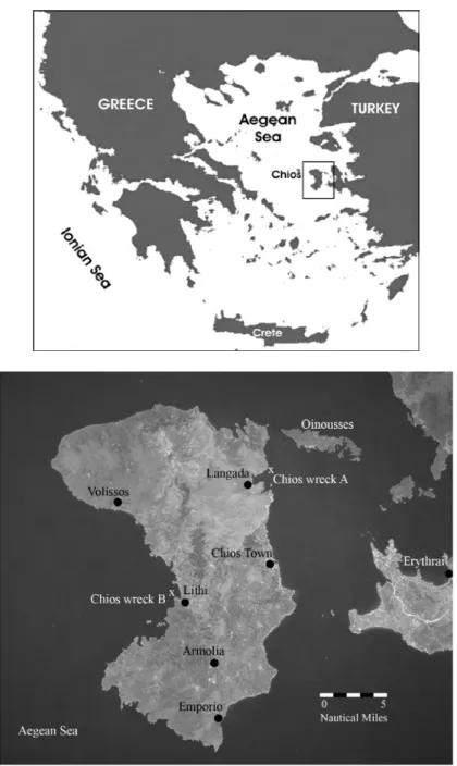
As noted above, Chios wreck A is located in the strait between Chios and Oinousses, roughly a kilometer from the shore near the village of Langada (Fig. 1).7 The wreck is embedded in a flat, silty seafloor in approximately
70 m of water. The team selected this wreck for AUV survey because it is archaeologically significant, its depth exceeds conventional scuba div-ing limits, and the flat seafloor is a benign environment for AUV robotic operations.
Survey by AUV is a new approach to archaeological site investigation. To test the technology and develop methods for its use, the team budgeted
Figure 1. Overview and detail showing location of the 2005 Chios shipwreck surveys and other sites
mentioned in the text. Original photo
(STS078-732-53) courtesy the Image Science and Analysis Laboratory, Johnson Space Center, NASA; adapted by B. P. Foley
7. Near Langada is the Classical farm site of Delphinion: Garnett and Boardman 1961, p. 106; Yalouris 1986, pp. 157, 163, 166.
eight days of ship time to complete the survey of the 4th-century b.c. wreck, deeming that period sufficient to overcome any equipment failures. Fortu-nately, weather conditions were ideal and the AUV performed to expectations. We completed operations on the Chios wreck A site within three calendar days, and all AUV operations within 24 hours. With the remaining ship time, we conducted additional investigations in the Chios Strait: side-scan sonar and sub-bottom profiling sonar surveys, and video examination (with the HCMR ROV) of geological features and a modern-era shipwreck site.
After survey of the Classical-period wreck and three days of operations in the Chios Strait, the team moved to the western side of Chios, near the village of Lithi, to investigate reports of a Roman wreck (Chios wreck B) that was thought to date to the 4th century a.d. We deployed the ROV, located the wreck site at depths of 36–42 m, and conducted AUV and diver operations at the site (Fig. 1). Based on the style of amphoras observed on Chios wreck B, the site dates not to the 4th century a.d., but to the late 2nd/early 1st century b.c.
The Autonomous Underwater Vehicle and Onboard Sensors
The AUV deployed for the Chios project measures less than 2 m long and 2 m high, and is lightweight (approximately 200 kg). This allows it to be deployed from a wide variety of vessels, including small coastal craft or fishing boats (Fig. 2). The robot’s flotation and a pressure housing contain-ing computers are mounted in an upper hull, while its batteries and other heavy components are mounted in a lower hull. The two hulls are connected by struts, upon which are mounted two fore-and-aft thrusters. The lower hull contains a vertical thruster. This double-body arrangement separates the center of buoyancy from the center of gravity, so the robot is passively stable in pitch and roll. Combined with precise control of multiple thrust-ers, passive stability grants the AUV capability for extremely slow-motion operation, thereby allowing dense data collection during surveys.8
Three types of sensors were on board the AUV during the 2005 survey: navigation sensors for real-time positioning and guidance, optical and sonar sensors for mapping the seafloor and its features, and in-situ chemical sensors for quantifying the oceanographic environment.9 A
downward-facing digital camera was mounted forward in the lower hull of the robot, and its single synchronized incandescent strobe light was posi-tioned aft in the lower hull. This arrangement optimized camera-to-light separation, reducing optical backscatter in the digital images. A multibeam mapping sonar was mounted just aft of the camera, and the DVL dead-reckoning navigation and altimetry sonar was fixed in the rear of the lower
8. Singh et al. 2004, pp. 289, 294– 295.
9. Navigation sensors included Tele- dyne Benthos 6000 Series long baseline (LBL) transponders, a Teledyne RD Instruments 1200 kHz Doppler veloc- ity log (DVL), and an IXSEA Octans fiber-optic gyrocompass. The optical
and sonar payload sensors were a Cooke Corporation Pixelfly 12-bit 1.2 megapixel single-chip color digital camera with synchronized strobe, and an Imagenex Delta T (260 kHz) multi- beam imaging sonar. The in-situ chem- ical payload sensors consisted of a Sea-Bird Electronics SBE49
conduc-tivity-depth-temperature (CDT) sensor; Chelsea Technologies Group Aquatracka aromatic hydrocarbon fluorometer; Seapoint Sensors chloro- phyll fluorometer; and a Seapoint Sen- sors chromophoric dissolved organic matter (CDOM) fluorometer.
hull.10 Chemical sensors mounted within the lower hull measured
salin-ity, temperature, chlorophyll, chromophoric dissolved organic matter (CDOM), and aromatic hydrocarbons. Because all of these sensors were incorporated into a single, passively stable, precisely navigated platform, the resulting coregistered data sets could be overlaid, thus enhancing in-terpretation and understanding of the wreck and its environment.
Precision Autonomous Navigation for Archaeolog y
Precision navigation makes possible the coordination of observations from multiple sensors into accurately overlaid maps, transforming purely obser-vational exploration into systematic scientific investigation.11 The requisite
positioning precision of the underwater vehicle varies depending on sensors and data products. The navigation system’s functional requirements for archaeological site investigations off Chios are as follows:
1. The AUV positioning must be sufficiently accurate to locate the wreck site on the seafloor at the beginning of each survey, i.e., the absolute real-time horizontal positioning must be accurate to within 3 m.12 This was achieved through LBL
Figure 2. The SeaBED autonomous underwater vehicle, operated by the Deep Submergence Laboratory of the Woods Hole Oceanographic Institution. In four missions con-ducted within a 24-hour period, the AUV mapped multiple parameters of
Chios wreck A. Photo M. Grund
10. The DVL takes advantage of the Doppler effect to estimate velocity over the seafloor. For a full explanation, see Gordon 1996.
11. Singh, Whitcomb, et al. 2000, pp. 144–145.
12. We quantify the actual value of this design goal based on the notion of circular error probability (CEP),
the radius of a circle defining the 50% confidence in the AUV’s position. We define our desired position accu- racy based on the footprint of our initial AUV missions, the expected spatial extent of the wreck site, and the desire to ensure that each mission completely covers the target location. The chosen parameter of 3 m CEP
provides a 95% confidence that the survey will be centered within 6.3 m of the target location. This method implicitly assumes that there is zero bias in our positioning uncertainty. This assumption is justified by the fact that LBL acoustic positioning is a relative absolute GPS reference.
acoustic positioning, capable of absolute repeatability of approx-imately 1 m.13
2. The AUV must have sufficiently precise guidance to survey the wreck site with guaranteed optical and sonar sensor overlap, i.e., the real-time guidance must be capable of positioning adjacent tracklines with a relative uncertainty of less than 0.35 m.14 The
Chios survey used precise dead-reckoning, combining DVL measurements and Octans fiber-optic gyroscope heading ref- erence to estimate position. For the 30 x 45 m fine-resolution wreck survey, we consider the relative position uncertainty between the start and end points of adjacent tracklines as a worst-case scenario. The estimated standard deviation for the real-time positioning of the start and end points of adjacent tracklines is 0.26 m.15 This translates to an 80% confidence
interval for satisfying the 0.35 m requirement.
3. For AUVs to be useful for archaeology, the precision and accuracy of the final data product must be comparable to the state of the art in underwater archaeology, i.e., the post-processed accuracy of the localization solution should be within 0.10 m in three dimensions.
Compared to the direct survey method, the professional standard for mapping underwater archaeological sites, the AUV navigation results are acceptable. The direct survey method uses fiberglass tape measurements of multiple distances to various datum points. These measurements are combined via three-dimensional trilateration to estimate position.16 A
thorough consideration of the uncertainty in this standard technique shows that positions can be determined to within 0.043 m (95% confidence), but human mistakes can lead to gross errors in 20% of the measurements (outliers).17 The Chios survey utilized an off-line combination of LBL
absolute positioning with DVL dead-reckoning. The final navigational data product from the Chios surveys has a positioning uncertainty of approximately 0.145 m with 95% confidence,18 higher than the best-case
direct survey method results.19
Because both the real-time and off-line (post-processing) navigation measurements rely on the combination of redundant and complementary sensing modalities, the AUV survey execution is robust with respect to outliers in measurement. The vehicle autonomously filters the data in real time to remove spurious observations. The post-processing algorithms also remove any measurement errors. We believe this increase in uncertainty over
13. Whitcomb et al. 2000, p. 442. 14. This requirement is based on a 1.85 m across-track image footprint and a 1.5 m trackline spacing. See the fine-resolution survey described below. 15. We estimate the dead-reckoning position uncertainty using a measure-ment model for the combination of DVL velocity and Octans heading reference. The DVL velocity
measure-ment standard deviation is 3 mm/s, and the Octans heading accuracy standard deviation is 0.1° secant latitude. Dead- reckoning uncertainty is time depen-dent and nonlinear. The uncertainty is constrained to less than 0.3% of dis- tance traveled (using a simple random walk model integrating survey velocity of 0.2 m/s at 38° north latitude for distances greater than 75 m). This
metric of 0.3% distance traveled is only applicable because the heading refer- ence uncertainty tends to dominate the position uncertainty on these scales.
16. Rule 1989. 17. Holt 2003, p. 251.
18. Based on 0.074 m standard deviation.
the direct survey method is acceptable for four reasons: the site remained undisturbed by the survey, allowing for future repeated investigations; the resulting positioning is absolute and referenced to GPS coordinates; the positioning data range over a larger spatial area and at a greater depth than is realistically feasible using the direct survey method; and the navigational precision and accuracy were sufficient to generate useful site maps.
Shipwreck Surve ys off Chios
The survey of the 4th-century b.c. Chios wreck A consisted of four AUV missions. Repeatable absolute positioning within a stable reference frame provided a common coordinate space among missions. As the team’s un-derstanding of the site improved, efforts focused on increasingly finer-scale surveys to generate new awareness and knowledge of the site. For example, bathymetry measurements from the first survey informed subsequent sur-veys, allowing for a gradual increase in the resolution of the investigation. Chemical and optical data collected in later surveys could be overlaid on early bathymetric maps because the positioning was consistent in each of the missions.
During the first investigation phase, the team deployed the HCMR
Super Achilles ROV on the GPS coordinates recorded in 2004 and relocated
the wreck. With the site’s location reestablished, the team moored LBL transponders on the seafloor near the wreck in a geometry that optimized the accuracy of the long baseline solution. Once these transponders were deployed, the team surveyed their actual locations by repeatedly inter-rogating the range and bearing of the transponders from the surface ship while recording the ship’s GPS position. The resulting GPS locations of each transponder on the seafloor established a stable, global coordinate frame for all subsequent observations. Figure 3 shows the layout of the LBL transponders and the AUV positions in meters measured from an established latitude and longitude origin. This local coordinate frame is a Mercator projection relative to this fixed point, and it allows for easier navigational data processing while providing an absolute GPS coordinate reference.20
After locating the site with the ROV and placing seafloor transponders from the ship, the team initiated the second survey phase: a large-area reconnaissance intended to document the wreck’s environmental con-text. During this coarse investigation, the AUV collected photographic, bathymetric, and chemical observations over an area of 50 x 100 m. The duration of this AUV dive was nearly three hours. This initial AUV mis-sion established the location of the wreck within the local LBL coordinate system and provided an opportunity for an empirical check of the AUV’s camera settings and lighting. After recovering the AUV, the team reviewed the images collected during the dive and refined the camera settings and survey plan in preparation for the second mission.
The third and final survey phase consisted of three fine-resolution AUV missions in order to produce comprehensive digital imaging, multi-beam sonar, and chemical maps of the wreck and the seafloor immediately
Figure 3 (opposite). (a) LBL trans- ponder layout in relation to wreck site, and (b) position of wreck within LBL network showing precision-navigated tracklines of AUV based on comparative position data from LBL, DVL, and LBL/DVL
combi-nation. B. S. Bingham
20. We measure survey positions based on the World Geodetic System 1984 (WGS-84), using the standard GPS geodetic coordinates of latitude, longitude, and height.
a
surrounding it. The relatively small scale of the site and its artifacts dic- tated positioning precision sufficient to resolve fine features (i.e., features < 0.10 m). To produce photomosaics, this resolution is primarily a function of the optical camera parameters, the resolution of individual images, and the camera’s distance from the seafloor. For most forms of bathymetric and chemical observations, the resolution of the final map is dependent upon sensor parameters, survey parameters, and positioning accuracy.
To obtain fine-resolution data, the team again programmed the AUV to swim in grid patterns over the wreck at an altitude of 2.5 m, collecting overlapping data as the vehicle transited over the site at four different orien-tations. The total area of coverage during the survey was 30 x 45 m, centered on the wreck site. The AUV’s speed over ground was 0.20 m per second, or 0.39 knots. The AUV’s camera collected images every three seconds, syn-chronized with its strobe light. At an altitude of 2.5 m, the camera footprint on the seafloor was approximately 1.50 m along-track by 1.85 m across-track. This altitude, image collection rate, and speed over ground resulted in ap-proximately 60% overlap along-track in successive images. Tracklines were spaced 1.5 m apart, theoretically providing a 20% digital image overlap in adjacent tracks. The multibeam sonar collected data continuously throughout the mission, with an average swath width of 5 m providing more than 100% overlap between adjacent tracks. Onboard environmental sensors measured water temperature, salinity, aromatic hydrocarbons, concentrations of dis-solved organic matter, and chlorophyll levels.
21. Singh, Adams, et al. 2000; Pizarro and Singh 2003; Singh, How-land, and Pizarro 2004.
TABLE 1. DURATION OF AUV MISSIONS AUV Mission Duration (hr:min)
1 ca. 03:00 2 02:42 3 02:19 4 01:23
These successive survey missions, of varying duration (Table 1), re-sulted in more than 7,000 high-resolution digital images of the wreck and surrounding seafloor. After color correcting and histogram equalizing the raw digital images, the team assembled photomosaic strips of the wreck site.21 Partial mosaics of the wreck were in the hands of the archaeologists
within hours of data collection. At the same time, the engineering team used the information derived from the AUV’s multibeam sonar and navigation sensors to generate preliminary bathymetric maps of the wreck site. With these data, the survey was complete, and the archaeological interpretation of the Chios wreck A site and its features commenced.
After conducting a few days of side-scan sonar surveys and ROV in-spection of sonar targets in the Chios Strait, the team shifted operations to the western side of Chios to investigate the reported but undocumented Roman-era shipwreck, Chios wreck B. As noted above, we deployed the ROV and located the site at depths ranging from 36 to 42 m. This site
consisted of a scatter of approximately 40 amphoras, apparently all of the same type, lying very close to shore at the foot of a steep, rocky slope—a difficult environment for robotic survey and ship operations. Landslides had disturbed the site, breaking amphoras and partially obscuring them under rocks and sediment. The visible artifacts were heavily encrusted with marine growth and posidonia grass.
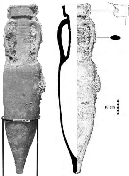
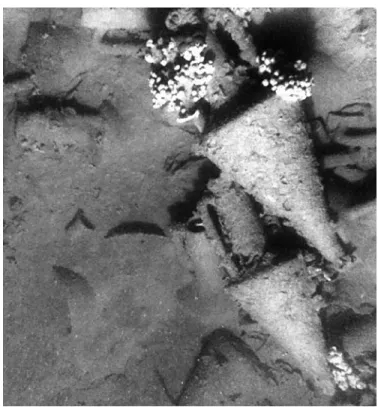
Because this site was shallow enough to achieve DVL bottom lock from the surface while the AUV was also receiving a GPS position fix, it was not necessary to deploy the LBL transponders. The team’s divers recon-noitered the site and recovered a single Dressel 1C (Will Type 5) amphora with an incuse stamp on the rim (Fig. 4). This amphora type indicates a much earlier, Hellenistic, date for the wreck than expected, placing it in the late 2nd/early 1st century b.c.22 We then deployed the AUV.
Dur-ing a two-hour mission, the vehicle followed the depth contours along headings parallel to the underwater slope. The AUV collected the same types of data as during previous missions, including more than 2,000
22. Peacock and Williams 1986, p. 91; McCann et al. 1987, pp. 201– 203; Sciallano and Sibella 1991, p. 34.
Figure 4. Dressel 1C (Will Type 5) amphora, with detail of an incuse stamp on its rim, recovered by divers from the Hellenistic wreck B site off
Lithi, Chios. Photo P. Vezirtis; drawing
images of the debris field and surrounding seafloor. These images were later assembled into photomosaic strips (Fig. 5). While the robot surveyed the site, divers collected video footage of the AUV and amphora scatter. After recovering the vehicle, we discovered sea water intrusion in some of the AUV components. As this was the last day of our allotted ship time, we concluded AUV operations off Chios.
Digital Image Mapping
While GPS allows surface and air vehicles to track their global posi-tion to within a few meters, GPS radio signals do not penetrate under water.23 Therefore, typical methods for underwater navigation usually rely
upon beacon-based navigation networks such as long baseline to offer bounded error position measurements. Use of this method comes at an expense, however, because it requires the predeployment and calibration of the beacon network as described above. Conversely, although dead-reckoning-based navigation technologies such as DVL do not require a predeployed infrastructure, their position accuracy decreases with the distance traveled.
To combat these navigational limitations (i.e., infrastructure-based and unbounded error growth), team members at WHOI have been developing a camera-based navigation system. This system uses the vehicle-collected imagery of the seafloor to extract measurements of vehicle motion for fu- sion with the onboard dead-reckoning data in order to produce a bounded- error navigation measurement.24 In essence, the AUV builds a digital map of
the seafloor by registering overlapping digital-still images (both along-track and across-track imagery). Images that are successfully registered produce a relative measurement of both the vehicle’s attitude (heading, pitch, and roll) and translational (x, y, z) displacement. When fused with the onboard navigational data from the DVL, the result is a navigation system whose error is commensurate or much better than long baseline, but which is free of external infrastructure such as LBL transponders. The significant advantage of this navigation paradigm is that the AUV can be more eas-ily deployed for exploratory surveys to investigate target shipwreck sites without having to invest significant ship time to deploy an acoustic beacon network for precision navigation. In layman’s terms, these algorithms allow the AUV to navigate much like a human does, by navigating visually with respect to the seafloor environment.
An important and useful by-product of this navigation methodology is that the overlapping registered imagery can be used to construct an opti-cally generated bathymetric map. This map can then be used to construct a quantitatively accurate three-dimensional photomosaic by back-projecting the imagery over the optical bathymetric map. Figure 6 displays the re-sult of applying this technology to the Chios wreck A site. In particular, Figures 6:a and 6:b show the optically derived bathymetric map for a 15 x 45 m swath centered overtop the wreck site. Figure 6:a shows the raw
23. Kinsey, Eustice, and Whitcomb,
Figure 5 (opposite). Photomosaic strip of Hellenistic Chios wreck B
near Lithi. B. P. Foley and Deep
Submer-gence Laboratory, Woods Hole Oceano-graphic Institution
Figure 6 (above). Chios wreck A site: (a) Raw three-dimensional triangu-lated point cloud of optically derived bathymetry; (b) three-dimensional bathymetric map gridded at 5 cm;
(c) quantitatively accurate three-dimensional photomosaic obtained by back-projecting digital imagery onto the gridded surface shown in (b). R. M. Eustice
a
b
three-dimensional triangulated point cloud, while Figure 6:b displays a bathymetric map gridded at 5 cm. Figure 6:c displays a quantitatively accurate three-dimensional photomosaic obtained by back-projecting the imagery onto the gridded surface. It should be emphasized that this result is fully automatic and metrically quantitative. In other words, measure-ments of object size and geometric relationships can be derived. While this technology is still very much in the active research stage, its current and future value for in-situ, rapid, quantitative documentation of marine archaeological sites cannot be overstated.
Acoustic Mapping
Multibeam sonar systems collect bathymetric data in a fan-shaped swath that is wide in the across-track direction and narrow in the along-track direction. These sonar systems are capable of providing dense data sets of bathymetric soundings that can be used to quantify the fine-scale charac-teristics of objects on the seafloor, as well as the seafloor itself. Bathymet-ric maps are generated by merging these sonar data with high-precision navigational data.25
There are a number of instrument-specific variables that affect the resolution of a multibeam sonar system, including sound frequency, beam pattern of the sonar as dictated by the transducer design, seafloor roughness, and the range (distance) to the bottom. The swath width of a multibeam system is a function of the angular sector of the transducer and the distance from the seafloor. The size of the acoustic footprint on the seafloor can greatly affect the resolution of the final map, as a large acoustic footprint over fine-scale complex seafloor terrain will not resolve the details of the seafloor, but will reveal broader bathymetric patterns. The acoustic footprint becomes larger with increasing distance from the seafloor. As a result, the acoustic footprint is smaller near the center of the swath and increases toward the edges of the swath. Similarly, the acoustic footprint increases with increased vehicle altitude.
Additional variables that affect the resolution of the final map are dependent on data-acquisition protocols. For example, the spatial density of bathymetric soundings is dependent on ping rate, vehicle speed, and vehicle altitude. While along-track data density is primarily dependent on survey speed and ping rate, across-track data density is dependent on characteristics of the multibeam system (e.g., beam width) and distance from the seafloor.
Multibeam sonar data collected during the Chios survey were gridded at 5 cm resolution (Fig. 7). This resolution is sufficient to reveal the detailed characteristics of the wreckage and the surrounding seafloor. There is no sign of a debris trail around wreck A. The wreck itself is bathymetrically complex; but even in the initial sonar plots, individual amphoras spatially isolated (horizontally or vertically) from the wreckage could be identified. With substantial post-processing of the sonar data, individual artifacts within the amphora mound can be discerned (Fig. 7, inset).
F
igure 7.
Mult
ibeam sonar bath
ymet
ric maps of the Chios w
rec
k A site.
T
he bottom image depicts the first sur
ve y phase of the w rec k and its sur roundings. T
he inset image is the p
ost-pr
ocessed data col
lected o
ver the w
rec
k in the final sur
ve y phases. V . L. F err ini and C. Ro man
ENVIRONMENTAL CONTEXT AND IMPLICATIONS FOR PRESERVATION
During the Chios AUV surveys, in-situ chemical parameters were measured at both shipwreck sites using a suite of onboard sensors. The chemical pa-rameters included salinity, temperature, chlorophyll, CDOM, and aromatic hydrocarbons. These parameters are useful in determining the thermal and kinetic energy inputs and mixing of the water, as well as the levels of biological and anthropogenic activity at the sites. Although the two Chios wreck sites are of roughly comparable age, lie in close proximity, and both sit in relatively shallow water, the data show that they have significantly different patterns of environmental degradation.
Salinity and temperature measurements at the older Chios wreck A site indicate a continuous gradient of decreasing temperature and de-creasing salinity as functions of depth. These parameters exhibit absolute homogeneity in the overlying 2.5 m altitude waters of the site, showing no discernible temperature variability (resolvable precision = 0.01°C) and no variation in salinity (resolvable precision = 0.01‰) (Fig. 8). Along with the absence of any detectable benthic currents, this suggests that the waters at this depth have had sufficient time to mix to equilibrium. Although the Bora and Meltemi seasonal winds routinely reach extremely high veloci-ties in this region, modeling of the bathymetric shape and fetch limit of this section of the Chios Strait predict that storm energy imparted into the water column would be dissipated before reaching this wreck site.
Figure 8. Salinity and temperature data plots comparing the physical environments of the two wreck sites
off Chios. R. Camilli
Depth (meters)
Optical and acoustic multibeam imagery of the area reveals a large contigu-ous amphora pile generally resembling an ellipse. The area surrounding Chios wreck A lacks the obvious furrow marks in the sediment charac-teristically made by the otter doors on trawl fishing nets, and there is no indication of a scour crater around the perimeter of the amphora mound. Overall, the data suggest that the wreck site has been undisturbed by storm events, benthic currents, or trawl fishing since its sinking.
The Chios wreck A site also appears to support limited photosyntheti-cally derived biological activity. Optical imagery shows very little biological encrustation of wreck artifacts. In contrast, imagery from the Chios wreck B site clearly shows widespread encrustation, with sizable beds of posidonia grass around the artifacts. However, chlorophyll concentrations measured throughout the overlying water column at both sites were approximately 2.5 mg/l, with little variability.
A step change in aromatic hydrocarbon concentrations occurs near the seafloor around Chios wreck A, increasing by a factor of three in the lowest 10 m of the water column (Fig. 9). The seafloor is generally com- posed of silty sediments exceeding 15 m in thickness.26 At the wreck site
itself, aromatic hydrocarbon concentrations decrease. A plume of low
26. Sakellariou et al. 2007, p. 371.
Figure 9. Chios wreck A survey, AUV dive 3: chemical parameters measured over the 4th-century b.c.
concentration advects from a point source over the amphora mound, fanning out westward along a straight line from the mound. This lower concentration plume is also found in CDOM values at the site. Objects on this ancient wreck provide structural habitat attracting marine life; the hard ceramic material acts as a holdfast substrate for sponges and other invertebrates. The lower aromatic hydrocarbon and CDOM plume may be caused by waters advecting past benthic filter feeders (i.e., sponges).
In contrast, the Chios wreck B site averaged a sixfold decrease in water column aromatic hydrocarbons and a 16% decrease in CDOM concentra-tions relative to the Chios wreck A site. An obvious explanation for the characteristic differences in aromatic hydrocarbon and CDOM concentra-tions is that the seafloor underlying the Chios wreck B site is largely com-prised of rocky material instead of silty organic sediments. Furthermore, no anomalous depth-dependent aromatic and CDOM concentration changes were observed at the Chios wreck B site, nor was there any indication of localized variability in concentrations.
Further investigation of the environmental states at these sites is needed before definite conclusions can be reached as to the transformative mecha-nisms affecting them. Preliminary in-situ data suggest that Classical Chios wreck A may be better preserved than nearby Hellenistic Chios wreck B because of sediment chemistry, and because the basin’s physical shape restricts kinetic energy inputs. The basin bathymetry appears to decouple Chios wreck A from wind and wave energy at the surface. The photographic and chemical data suggest that Chios wreck A may exist within a hypoxic basin. Although the chlorophyll levels are similar at the two sites, the evident lack of photosynthetic organisms and enriched organic concentra-tions within the sediments could enable a sustained microbial drawdown in dissolved oxygen. This sustained decrease in oxygen would greatly limit biological activity/encrustation of the wreck site, thereby attenuating bio-logical degradation of organic materials and artifacts at the site.
ARCHAEOLOGICAL EVIDENCE
Multibeam sonar data show that the 4th-century b.c. Chios wreck A site forms an ellipse on the seafloor, with a maximum length of 21 m, a width of 8 m, and a vertical relief of 1.4 m. The cargo remains are tightly contained within the dimensions of the wreck site; there is no debris trail around the wreck. The visible cargo remains consist of more than 350 amphoras of two types. The first type is attributed to Chios, with a generally oblong shape with a high straight neck, long vertical handles with high attachment points, conical body, carinated shoulder, and spiked base with a conical cup toe. The origin of the second amphora type is unknown. This amphora has a relatively short neck, short vertical handles, globular body, and a spiked base terminating in a knob toe.
Figure 10 represents a composite image assembled from hundreds of in-dividual digital pictures, providing an otherwise impossible view of the wreck and its cargo. Of the observable Chian amphoras, 94 are intact, and 73 are broken.27 In the area containing the Chian amphoras, another 101 amphoras
27. Many of the broken Chian amphoras have fractured cleanly at the shoulder or at the base of the neck. Dynamic computer modeling of that style conducted at WHOI confirms the observation that these are the weakest points of the shape. When subjected to external pressure or shock, the Chian amphora fractures along the seams at the shoulder or the base of the neck.
Figure 10 (opposite). Photomosaic of Chios wreck A, with major features
identified. B. P. Foley and Deep
Submer-gence Laboratory, Woods Hole Oceano-graphic Institution
are visible. They appear to be Chian, as well, but are too covered in sediment to determine if they are intact or broken. The digital images show that the Chian amphoras have similar dimensions, with one exception (Fig. 11, lower right) that is somewhat smaller than the predominant type.
In 2004, HCMR and EUA scientists recovered from the site a well-preserved Chian amphora, designated BE2004/4.1 (Fig. 12). The vessel is intact except for one missing handle, but traces of that handle’s attachments remain on the neck and shoulder. The clay color is red (Munsell 2.5YR 5/6), and the amphora’s dimensions are overall height 0.915, maximum diameter 0.340, handle height 0.320, toe height 0.070, depth of recess in toe 0.040, and neck inner diameter 0.087 m. EUA archaeologists measured the volume of this amphora by filling the jar with water, according to ac-cepted practice.28 The volume to the base of the neck is 19.0 l, and the
total volume to the rim is 22.0 l.
The second amphora type found at wreck A is of an unattributed va-riety. There are 30 intact examples of this type discernible in the imagery, at least 12 that are broken, and many fragments representing an unknown number of additional amphoras. In 2004, HCMR and EUA recovered one amphora of this type, designated BE2004/4.4 (Fig. 13). The clay color is light red (Munsell 2.5YR 6/6), and the amphora dimensions are overall height 0.665, maximum diameter 0.400, handle height 0.145, neck height 0.140, and neck inner diameter 0.085 m. The capacity of this amphora was also measured by filling it with water.29 The capacity at the base of the neck
is 32.4 l, and the total internal volume measured at the rim is 33 l. The digital images of Chios wreck A show mouths of 37 more am-phoras visible in the sediments, but it is impossible to determine their type or condition. They appear to be standing upright, and they may still be in
28. Docter 1990, p. 149. 29. Docter 1990, p. 149.
Figure 11. View of full-sized and smaller Chian amphoras on Chios wreck A, shown in situ, viewed from southeast. Sponges are growing on both amphoras, and modern trash (plastic cup) can be seen in left center
Figure 12. Chian amphora BE2004/4.1 recovered from Chios wreck A by HCMR and EUA in
2004. Photo P. Vezirtis; drawing E. P.
Oberlander
Figure 13. Unattributed amphora BE2004/4.4 recovered from Chios wreck A by HCMR and EUA in
2004. Photo P. Vezirtis; drawing E. P.
their original loading positions, possibly indicating that additional layers of amphoras may be buried in the sediments below the observable artifacts. By comparison, a 5th-century b.c. wreck excavated at Alonnesos contained four tiers of amphoras occupying 1.5 m of vertical relief.30
The extreme western end of Chios wreck A contains a feature that is suggestive of an anchor shank and arm (Fig. 14). This feature is less than 2 m long, however, and may be too small for ground tackle.31
The photomosaic (Fig. 10) reveals a small area (about 1.5 m2) of
decreased amphora density along the centerline near the western end of the wreck. This might represent the location of the ship’s mast. Nearby, the toe of one amphora of perhaps Thasian or northern Aegean type is evident (Fig. 15).32 This area also contains an assemblage of several small
pots possibly used by the crew, or perhaps representing a secondary cargo consignment in addition to the amphora cargo.
A single example of a jug (designated BE2005/4) was recovered from Chios wreck A using the HCMR ROV in 2005 (Fig. 16). BE2005/4 is a plain-ware jug missing the rim, part of the neck, the handle or handles,
30. Hadjidaki 1996, p. 574. 31. Casson 1995, pp. 254–256. 32. Monakhov and Rogov 1990, p. 144.
Figure 14. Possible anchor at western end of Chios wreck A, alongside
and part of the body. It has a compressed spherical/ovoid body and a ring base. The clay is reddish brown to dark reddish gray (Munsell 5YR 5/3), and the dimensions of the jug are overall height 0.175, diameter 0.170, and base diameter 0.095 m. The inner surface was coated with a thin layer of earthlike material, which has not yet been analyzed. This jug is a plain wide-neck type with a slightly angular shoulder; the base of one handle is preserved. A close parallel of the vessel had been found earlier in the Chios harbor.33 The Chios wreck A jug can be dated within the 4th century b.c.
and placed stylistically between a type A jug of the Ephesos Tetragonos Agora (first half of 4th century b.c.)34 and a series of jugs from Rhodes
(last quarter of 4th century b.c.).35
33. This unpublished jug was re- trieved in 1985 from the southern part of the Chios harbor along the inside of the southern mole during an illegal dredging operation that was halted by EUA. The jug initially was placed in the collection of the Chios Archaeolog-
Figure 15. Toe of an unidentified (possibly Thasian) amphora on Chios wreck A, located alongside
Chian amphoras. Photo Chios 2005
team
ical Museum (inv. 4063) and later in 1985 was moved to the Conservation Laboratory of EUA, where it was re- numbered as 85/34. The neck and rim are broken and the handle is missing, but the jug has the same shape as the jug from Chios wreck A. Its
dimen-sions are max. p.H. 0.20, max. Diam. 0.18, base Diam. 0.09 m.
34. Ephesos XIII.2, pp. 89–90, fig. 101, the first vessel to the left; see also p. 328, and pl. 14, no. 95.
35. Giannikouri, Patsiada, and Phili- monos 2000, p. 75, pl. 23:β, no. Π8181.
Figure 16. Small jug BE2005/4 recovered from Chios wreck A in 2005 by HCMR Super Achilles ROV. Photo P. Vezirtis; drawing E. P. Oberlander
TABLE 2. SHIPWRECkS ROUGHLY CONTEMPORARY WITH CHIOS WRECk A Location of Shipwreck Est. Date B.C. Site Length (m) Site Width (m) Amphora Cargo
Tektaş Burnu, western Turkey 440–425 12 4 200
Alonessos, Sporades, Greece 410 25 14 1,000 (top layer); 4,000 total? Porticello, Messina, Sicily 390 16 ? looted
El Sec, Mallorca, Spain 375 similar to Kyrenia similar to Kyrenia total 475, but looted Chios wreck A 350–330 21 8 350 (top layer) Kyrenia, northern Cyprus 295–285* 14 4.5 total 400+ Serçe Limanı, southwestern Turkey 280 11 9 total 600+
*The Kyrenia wreck was originally published as dating to ca. 325 b.c.; see Katzev 1972.
Sources: Carlson 2003, 2004; Hadjidaki 1996; Lawall 1998a; Arribas et al. 1987; Susan Katzev, pers. comm.; Pulak and Townsend 1987. Note: Two other Classical wrecks are not included in this table, either because the cargo was not primarily composed of amphoras or a
complete survey was not performed. The Ma‘agan Mikhael wreck (ca. 410–390 b.c.) off Israel carried building materials rather than an amphora cargo; see Linder, Kahanov, and Black 2003. The Phagrou wreck in Greece (ca. 450 b.c.) carried amphoras, but awaits survey.
In addition to the objects carried on the vessel when it sank, the wreck has trapped modern trash, including plastic bags, cups, and water bottles (see Figs. 10 and 11, above). This material has been carried onto the site by benthic currents—a phenomenon long observed on other deepwater shipwreck sites. Ancient debris also travels across the seafloor; anachronistic artifacts encountered in the supposedly closed context of a wreck site may be explained by this mechanism.36
In comparison to other roughly contemporary shipwrecks, Chios wreck A is larger than all but the Alonnesos vessel (Table 2). The number of amphoras visible on wreck A’s top layer is evidence that it was a relatively large ship for its time, but further investigation is necessary to determine the total number of amphoras contained within the 1.4 m tumulus.
As described above, the Chian amphoras on the wreck site are straight-necked with a conical cup toe (see Fig. 12). Intact examples and sherds of similar jars have been excavated from 4th-century b.c. contexts in the northern Black Sea. Chian “dunce cap” toes appear in a stratum dating to the middle of the 4th century b.c. from the Belozerskoe settlement near the mouth of the Dnieper River, Ukraine.37 Complete examples
were excavated from child burials in the necropolis tumulus at Panskoe I in westernmost Crimea, dating to the third quarter of the 4th century b.c.38
Closer to Chios, sherds of similar cup-toed amphoras have been studied at Ilion. They were excavated from strata dating no later than 330 b.c.39
The Chian amphoras contained within Chios wreck A conform closely to the mid-century form. An exact parallel has also been found in the Athenian Agora: Chian amphora P 25947.40 This amphora was excavated
36. Parker 1981, p. 309. Investiga-tions of deepwater sites reveal that the deep seafloor is more dynamic than Parker suspected, and ancient and mod-ern artifacts may move greater distances than previously imagined; see Foley and Ballard 2004.
37. Bylkova 1996, 2005, pp. 221, 236; Lawall 2005, pp. 43, 45.
38. Monakhov and Rogov 1990, p. 138. Hind (1992–1993, p. 92) re- ports Chian amphoras imported into 5th- and 4th-century b.c. Nikonian and Ordessos, in modern-day Ukraine.
39. Lawall 2002, pp. 202, 204– 205.
from fill in deposit F 17:3 that is dated to the second half of the 4th cen- tury b.c.41 Taking all of this into account, it seems most likely that the
ship sank sometime between 350 and 330 b.c., and certainly no later than 315 b.c.
Earlier Chian amphoras differed significantly in style and capacity from the mid-4th-century form.42 From the end of the 6th century to the middle
of the 5th century b.c., Chian amphoras featured a distinctive bulbous neck, and their internal volume averaged seven Chian choes. In the later 5th century, the capacity of this Chian amphora style might have increased to eight Chian choes, equivalent to seven Attic choes. Then the new form of straight-necked Chian amphoras appeared. Production of the bulging-neck style might have overlapped with the new style until ca. 425 b.c., when the bulging-neck amphora was fully superseded by the straight-necked style.43 The straight-necked style had a capacity of eight Chian
choes, equivalent to seven Attic choes.44 The initial change in capacity
and subsequent change in style reflected in the bulbous-to-straight neck transition might have resulted from the Athenian Standards Decree, under which the Chian producers conformed to the Attic standard. Among the scholars who point to this decree as the reason for the change in measure, there is disagreement about the date of its issuance. Some scholars posit a date of 448–446 b.c.,45 but more recently, others have convincingly argued
for a date around 424 b.c.46
Political changes can be reflected in the objects produced by a society, and the history of Chian coinage provides good examples of this phe-nomenon. Chios minted coins on its own standard from 525 b.c. until the Athenian Standards Decree, when a break occurred in coin production. In 412 b.c. the Chians revolted against the Athenian League, and they resumed minting coins based on their own standard.47 Relations between
Athens and Chios warmed for a period with a new Second Athenian League alliance in 379/8,48 but tensions soon built again, erupting with
the Social War of 358/7–355/4 b.c. At this point, Athens attacked Chios and possibly fomented an insurrection of the sizable slave population on the island. Ultimately, Persian intervention resulted in Chian independence from Athens.49 Throughout the politically tumultuous period following the
412 b.c. revolt, Chian coins conformed to the island’s own standard.50
Changes in Chian amphora measures might amplify the trends evident in the island’s coinage standards. The transition from bulging-neck to
41. Agora XII, p. 390. See also
Agora XXIX, p. 451, where the stated
provenance of the amphoras from deposit F 17:3 (the wall of a well filled after 315 b.c.) provides a terminus ante quem for this amphora. The shapes and dimensions of the Agora amphora and amphora BE2004/4.1 from Chios wreck A are similar. The Agora am- phora’s dimensions are overall H. 0.947, max. Diam. 0.332, handle H. 0.342 m. We thank Carolyn Koehler and Susan Rotroff for their assistance in
compar-ing these amphoras to those of Chios wreck A.
42. Lawall 1998b, p. 78.
43. Grace 1979; Lawall 1998b, p. 81. 44. Mattingly 1981, p. 80; Wallace 1986, pp. 88–89. See also Koehler 1982, pp. 284–285. 45. Mattingly 1981, p. 80; Barron 1986, pp. 96, 98. 46. Hardwick 1993, p. 216; Mat-tingly 1993, p. 102; Schönhammer 1993, pp. 189–191; Lawall 1998b, pp. 94–95. 47. Hardwick 1993, pp. 216–218, 220. 48. Hornblower 2002, p. 233. 49. Peake 1997; Ruzicka 1998, p. 60; Hornblower 2002, pp. 175, 256.
50. Ashton et al. 2002, p. 216. The output of several other regional mints followed the Chian standard in the early 4th century b.c., including Kni- dos, Kos, Samos, Kyzikos, Thasos, Ephesos, Miletos, and Rhodes. See Ashton et al. 2002, pp. 242–243.
straight-neck amphoras around the time of the Athenian Standards Decree has been linked to the shift to an Attic standard measure, presumably in the 420s. To cut ties with the defeated Athenians after the 412 b.c. revolt, the Chians might have changed amphora measures back to their own stan-dard of seven Chian choes51 while maintaining the new straight-necked
amphora style. From two surviving Chian wine measures, Forrest measured the volume of a Chian chous as 2.88 l.52 Seven Chian choes therefore equal
20.16 l, so we would expect to see amphora capacities in this range. Some evidence for this capacity change exists in Chian amphoras excavated in a mid-4th-century context in the lower Don River region. Brashinskii notes that the capacities of the Don River jars range from 18.6 to 20.2 l.53 As
Lawall points out, definite conclusions about this possible capacity change must wait until a larger sample size of Chian amphoras dating before and after the Athenian Standards Decree can be investigated.54
Amphora BE2004/4.1 (Fig. 12) recovered from Chios wreck A adds one more data point to this debate. As noted above, the volume to the base of the neck is 19.0 l, and the total volume to the rim is 22.0 l. Docter tentatively suggests amphoras were filled halfway up the neck of the jar.55
If this Chian jar were filled halfway up its neck, the resulting volume would be 20.5 l, or within 2% of seven Chian choes. However, it is statistically unsound to base conclusions about the entire class of Chian amphoras from this wreck on a single sample.56 To verify a capacity standard for this
style of Chian amphora, additional measurements will be required from the amphoras on this shipwreck and other contemporary sites.
Chian products were traded extensively in the Classical and Hellenistic eras.57 Excavations of 5th-century strata in Athens and Corinth show large
quantities of Chian amphoras, and the island’s amphoras have been found in the southern Mediterranean at Naukratis in the Nile Delta,58 and farther
eastward, on Cyprus.59 Evidence from excavations in the northern Black
Sea area indicates markets for Chian products in that region during the 4th century b.c., and papyri record that Chios was a port of call for ships trading between Alexandria and the Black Sea during the 3rd century b.c.60
Additionally, Chian amphoras have been recovered from several shipwrecks; as Carlson notes, this may indicate that Chian products were widely traded, or it may simply reflect the fact that the distinctive Chian amphoras are
51. Boardman 1958–1959, pp. 306, 309.
52. Forrest 1956, p. 64. One of these Chian wine measures was on display at the Chios Archaeological Museum at the time we were preparing this manuscript; see Archontidou-Argyri and Kyriakopoulou 2000, pp. 160–161.
53. Brashinskii 1980, pp. 16–17; see also Whitbread 1995, pp. 36–37. Additionally, a Chian cap-toed am- phora excavated in the harbor at Athlit, Israel, had a capacity of 17.2 l, and a later Chian pointed-toe amphora re-
covered in the sea off Ashkelon, Israel, had a capacity of 20.5 l. No further information is available regarding these finds. See Zemer 1977, pp. 37– 39.
54. Lawall 2000, p. 7. 55. Docter 1990, p. 155. 56. An interesting discussion of problems in determining amphora capacities and volume standards ap- pears in Matheson and Wallace 1982, esp. p. 300, n. 21.
57. See Empereur and Garlan 1987, 1992, 1997; Drougou, Zervoudaki, and Touratsoglou 1998; Marangou-Lerat
2000; Garlan 2002. The best synthesis of Chian trade in the 5th century, based on a study of amphoras, is Lawall 1998b.
58. Archontidou-Argyri and Kokki- noforou 2004, p. 93.
59. A wreck with a cargo of similar Chian amphoras was located and brief- ly studied in 2007 off the coast of southeast Cyprus (Stella Demesticha, pers. comm.) See also Archontidou-Argyri and Kokkinoforou 2004, pp. 92– 95.
easily recognized and therefore more frequently reported than other types.61
Chian amphoras excavated from most sites have been interpreted as wine containers, although a few (possibly reused) examples recently studied by archaeologists were found to carry other products.62 From ca. 500 b.c.
until the Roman period, an amphora accompanied by a bunch of grapes was a persistent feature on Chian coinage. This has been interpreted as an advertisement for the island’s wine.63 Ancient writers across the centuries
noted the quality of Chian vintages. Strabo declared that the best Greek wine was produced in Ariusia, the mountainous northwestern region of the island (Strabo 14.1.35); and Pliny noted that Caesar provided Chian wine at his triumphal banquets (HN 14.16.97). Theopompos credited the Chians with the invention of “dark” or “black” wine, as differentiated from white or yellow wine.64 In the Deipnosophistae, Athenaeus quoted other
ancient authors’ claims that Chian wine was best of all, again singling out the Ariusian variety (Ath. 1.26b, 1.29e, and esp. 1.32f ). The ancient texts indicate that the distinctive Chian wine found a wide and eager market throughout the Greek world for centuries.
However, amphora BE2004/4.1 was not lined with resin, an indica-tion that it probably did not hold wine. To determine its contents, we extracted a small (<1 g) sample of ceramic from the interior wall of the jar and subjected it to molecular biological analysis, an unprecedented tech-nique fully described elsewhere.65 These analyses revealed ancient DNA
of olive and oregano.66 This result is intriguing; it demonstrates that this
type of amphora did not contain wine exclusively in its first use for export. Some portion of this ship’s cargo was composed of olive products carried in Chian amphoras. Additional samples must be collected and analyzed from more amphoras on this shipwreck before broader conclusions about the cargo can be drawn.
The capacity of the second amphora recovered from Chios wreck A, unattributed amphora BE2004/4.4, is 32.4 l at the base of the neck (11.2 Chian choes of 2.88 l each). The total internal volume measured at the rim is 33 l (11.4 Chian choes). It seems possible that this jar conformed to a different volume standard, perhaps the Attic standard. The exact measure of a standard Attic chous is unknown.67 Lang and Crosby’s estimate of 3.276 l
is generally accepted, often rounded down to 3.20 or 3.26 l.68 If we accept
the standard Attic chous as 3.26 l, then the unattributed amphora from Chios wreck A measures within ±1% of 10 Attic choes if filled halfway up the neck. As with the Chian amphora, broader conclusions about the amphoras of this unattributed type on Chios wreck A cannot be made without a larger sample size.
The bottom of amphora BE2004/4.4 contained a small lump of hardened shiny brownish resin. We collected a sample of the resin in May 2006 and submitted it for carbon-14 analysis to the National Ocean Sci-ences Accelerator Mass Spectrometry Facility (NOSAMS) at Woods Hole Oceanographic Institution.69 The radiocarbon date of the resin is 2400
± 30 years b.p., calibrated to a calendar date of 410 b.c. ±30 years. The calibrated calendar date is somewhat earlier than expected, considering the estimated date of the Chian amphoras on the wreck.70 The calibrated
61. Carlson 2004, pp. 142–143. 62. Barron 1986, pp. 98–99. A 5th-century b.c. Chian amphora recovered from the sea off Knidos contained hun-dreds of olive pits. However, it is not known if this represents the original contents or the reuse of the jar (Cemal Pulak, pers. comm.). Similarly, a single Chian amphora containing olive pits was recovered from the wreck near Aslan Burnu; see Kerameikos IX, pp. 23–24; and Carlson 2004, p. 139.
63. Hardwick 1993, p. 211. 64. Boardman 1967, p. 252; Whit-bread 1995, p. 144.
65. Hansson and Foley 2008. The great potential of this technique lies in its ability to detect the residue of ancient substances in empty amphoras.
66. Hansson and Foley 2008. 67. The Attic kotyle is believed to be 0.271 l and 12 times that volume equals 3.262 l, perhaps equaling an Attic chous.
68. Agora X, pp. 47, 58; Forrest 1956, p. 64; Koehler and Wallace 1987, p. 55.
69. We acknowledge the National Science Foundation’s support of NOSAMS under NSF Cooperative Agreement no. OCE-9807266.
70. The calibration curve for the Classical period is relatively flat and therefore problematic for radiocarbon analysis of artifacts from this era.