HAL Id: cea-03079420
https://hal-cea.archives-ouvertes.fr/cea-03079420
Submitted on 17 Dec 2020
HAL is a multi-disciplinary open access
archive for the deposit and dissemination of
sci-entific research documents, whether they are
pub-lished or not. The documents may come from
teaching and research institutions in France or
abroad, or from public or private research centers.
L’archive ouverte pluridisciplinaire HAL, est
destinée au dépôt et à la diffusion de documents
scientifiques de niveau recherche, publiés ou non,
émanant des établissements d’enseignement et de
recherche français ou étrangers, des laboratoires
publics ou privés.
Distributed under a Creative Commons Attribution| 4.0 International License
Impact of the 2019 typhoons on sediment source
contributions and radiocesium concentrations in rivers
draining the Fukushima radioactive plume, Japan
Olivier Evrard, Roxanne Durand, Atsushi Nakao, J. Patrick Laceby, Irène
Lefèvre, Yoshifumi Wakiyama, Seiji Hayashi, Cécile Asanuma-Brice, Olivier
Cerdan
To cite this version:
Olivier Evrard, Roxanne Durand, Atsushi Nakao, J. Patrick Laceby, Irène Lefèvre, et al.. Impact of
the 2019 typhoons on sediment source contributions and radiocesium concentrations in rivers draining
the Fukushima radioactive plume, Japan. Comptes Rendus Géoscience, Elsevier Masson, 2020, 352
(3), pp.199-211. �10.5802/crgeos.42�. �cea-03079420�
Comptes Rendus
Géoscience
Sciences de la Planète
Olivier Evrard, Roxanne Durand, Atsushi Nakao, J. Patrick Laceby,
Irène Lefèvre, Yoshifumi Wakiyama, Seiji Hayashi, Cécile
Asanuma-Brice and Olivier Cerdan
Impact of the 2019 typhoons on sediment source contributions and
radiocesium concentrations in rivers draining the Fukushima
radioactive plume, Japan
Volume 352, issue 3 (2020), p. 199-211. <https://doi.org/10.5802/crgeos.42>
© Académie des sciences, Paris and the authors, 2020.
Some rights reserved.
This article is licensed under the
Creative Commons Attribution 4.0 International License.
http://creativecommons.org/licenses/by/4.0/
LesComptes Rendus. Géoscience — Sciences de la Planète sont membres du Centre Mersenne pour l’édition scientifique ouverte
Comptes Rendus
Géoscience — Sciences de la Planète
2020, 352, n 3, p. 199-211
https://doi.org/10.5802/crgeos.42
Original Article — External Geophysics, Climate
Impact of the 2019 typhoons on sediment source
contributions and radiocesium concentrations
in rivers draining the Fukushima radioactive
plume, Japan
Olivier Evrard
∗, a, Roxanne Durand
a, Atsushi Nakao
b, J. Patrick Laceby
c, Irène Lefèvre
a,
Yoshifumi Wakiyama
d, Seiji Hayashi
e, Cécile Asanuma-Brice
f , gand Olivier Cerdan
haLaboratoire des Sciences du Climat et de l’Environnement (LSCE/IPSL), Unité Mixte
de Recherche 8212 (CEA/CNRS/UVSQ), Université Paris-Saclay, Gif-sur-Yvette, France
bGraduate School of Life and Environmental Sciences, Kyoto Prefectural University,
Kyoto, Japan
cAlberta Environment and Parks (AEP), Calgary, Alberta, Canada dInstitute of Environmental Radioactivity (IER), University of Fukushima,
Fukushima, Japan
eNational Institute for Environmental Studies (NIES), Fukushima Branch, Miharu,
Japan
fCNRS, IFRJ-UMIFRE 19 - MFJ, Tokyo, Japan
gCenter for Japanese Studies (CRJCentre de Recherche sur le Japon), UMR 8173
-EHESS, Paris, France
hBureau de Recherches Géologiques et Minières (BRGM), Orléans, France
E-mails: olivier.evrard@lsce.ipsl.fr (O. Evrard), roxanne.durand094@gmail.com
(R. Durand), na_4_ka_triplochiton@kpu.ac.jp (A. Nakao), Patrick.Laceby@gov.ab.ca (J. Patrick Laceby), irene.lefevre@lsce.ipsl.fr (I. Lefèvre),
wakiyama@ipc.fukushima-u.ac.jp (Y. Wakiyama), shayashi@nies.go.jp (S. Hayashi), asanuma.brice.cecile@cnrs.jp (C. Asanuma-Brice), o.cerdan@brgm.fr (O. Cerdan)
Abstract. The Fukushima nuclear accident in March 2011 generated a 3000 km2plume of soils heavily contaminated with137Cs. Decontamination was completed early in 2019. Typhoon Hagibis was the first extreme event that occurred in the region after decontamination. Its impact on sediment sources and sediment137Cs contamination was investigated through the application of a sediment fingerprinting procedure using spectrocolorimetry and geochemical properties. Sediment deposits (n = 24) were collected in the Mano and Niida River catchments after the 2019 typhoons, and their signature was compared to that of potential sources (e.g., cropland, forests, and subsurface; n = 57). Results demonstrate the dominance of cropland as the main source of sediment (mean: 54%)
∗Corresponding author.
followed by forests (41%) with much lower contributions of subsurface material (5%). Overall,137Cs concentrations in sediment were on average 84%–93% lower than the levels recorded after the accident in 2011, which demonstrates the effectiveness of cropland decontamination.
Keywords. Source tracing, Sediment fingerprinting, Nuclear accident, Catchment, Cesium-137
(137Cs).
Manuscript received 5th September 2020, revised and accepted 16th November 2020.
1. Introduction
The Fukushima Daiichi nuclear accident that oc-curred in March 2011 led to the release of significant quantities of radionuclides, including iodine-131 (131I), cesium-134 (134Cs), and cesium-137 (137Cs), into the atmosphere [Chino et al., 2011]. It is esti-mated that 20% of the released radionuclides were deposited on the Japanese land surface, forming a plume of approximately 3000 km2with initial137Cs levels greater than 100,000 Bq·m−2 northwest of
the power plant [Yasunari et al., 2011]. The most problematic radionuclide over the long term is137Cs as large quantities of this substance were released (12–62 PBq or 1015Bq) [Steinhauser et al., 2014]. Fur-thermore, its 30-year half-life is significantly longer than that of the other isotopes (8 days for 131I and 2 years for 134Cs). Without remediation measures, it will take approximately two centuries for137Cs to decay to negligible levels in soils of the main plume.
It is widely accepted that 137Cs is strongly and almost irreversibly bound to particles in continen-tal environments in general [Tamura, 1964] and in soils of Fukushima Prefecture in particular [Nakao et al., 2015]. This radioisotope was shown to be re-distributed across landscapes following soil erosion and deposition processes [Evrard et al., 2015]. These transfers are accelerated during flood events [Nagao et al., 2013] including those generated by typhoons, which occur frequently in Japan during the summer and early in autumn [Chartin et al., 2017, Laceby et al., 016a]. The redistribution of 137Cs with sedi-ment during floods is therefore a matter of great con-cern in this region [Yamashiki et al., 2014].
To accelerate the return of local populations in the fallout-impacted region, Japanese authorities con-ducted extensive decontamination activities in agri-cultural and residential areas [Evrard et al., 019c]. These works mainly consisted of the removal of the uppermost 5 cm layer of the soil, which was shown to contain 95%–99% of the137Cs concentra-tions [Lepage et al., 2015], and storage in specifically
designed areas [Yasutaka et al., 2013]. In contrast, decontamination was not implemented in forest areas covering approximately 75% of the surface area in the main fallout-impacted region [Hashimoto et al., 2012]. This may therefore provide a perennial source of contaminated material to the river systems draining the main radioactive plume [Laceby et al., 016b].
To quantify forest contributions to sediment and sediment-bound 137Cs transported in the rivers draining the main radioactive plume, sediment trac-ing or ftrac-ingerprinttrac-ing techniques that capitalize on the measurement of conservative properties in both potential sources and sediment have been imple-mented [Haddadchi et al., 2013, Owens et al., 2016, Walling, 2013]. Previous research in the Fukushima region has used different sets of parameters, includ-ing137Cs activity in soils [Evrard et al., 2016], elemen-tal geochemistry [Lepage et al., 2016], organic matter properties [Huon et al., 2018], or even environmental DNA [Evrard et al., 019b]. Recently, the potential of color to discriminate among cropland, forest, and subsurface (e.g., landslide and channel bank col-lapse) sources of sediment was also demonstrated in these catchments [Evrard et al., 019a]. This method is based on the major contrast observed between the dark-colored Cambisols and Andisols found under croplands and forests compared to the light-colored crushed granite extracted from local quarries. This material is used to replace the137Cs-contaminated topsoil layer with a new substrate as part of the remediation program.
These techniques were applied before the com-pletion of decontamination works in the main radioactive plume and the progressive reopening of the region to the inhabitants [Asanuma-Brice, 2018]. Early in 2019, soils were progressively prepared to allow for their recultivation through the mixing of the residual initial soil profile with a crushed gran-ite layer (Supplementary Material S1). This process requires the adaptation of the previously developed
Olivier Evrard et al. 201
sediment tracing methods (e.g., based on the color properties) to these new conditions.
Typhoons have been shown to generate exten-sive soil erosion and river flooding in Japan in gen-eral, and the Fukushima region in particular, with the potential to transfer significant quantities of sediment and particle-bound 137Cs in the rivers draining the main radioactive plume [Kurikami et al., 2016, Laceby et al., 016a, Taniguchi et al., 2019]. In October 2019, typhoon no. 19 (Hagibis), which made landfall on Japan on October 12, was reported to have generated the largest number of sediment dis-aster occurrences (e.g., landslides and mudflows) in Japan since 1982 [Irasawa et al., 2020], killing at least 93 people, including 31 in the Fukushima Prefec-ture, and leaving 2367 people homeless across Japan [Asanuma-Brice, 2019]. The heavy rainfall recorded during this event also led to the overflow of nu-merous rivers across Japan, including several coastal rivers draining the main radioactive plume of the Fukushima Prefecture.
As typhoon Hagibis generated extensive soil ero-sion, landslides, and flooding in the fallout-impacted region, the objective of the current research is to in-vestigate the impact of this heavy rainfall event on sources that delivered sediment to coastal river sys-tems, including decontaminated land, and on sedi-ment137Cs concentrations. The purpose is to investi-gate the effectiveness of remediation works and the contribution of forests during this type of extreme event.
2. Materials and methods
2.1. Study area
The study was conducted in the Niida (275 km2) and Mano (175 km2) coastal catchments (Figure 1) located to the north of the Fukushima Daiichi Nu-clear Power Plant (FDNPP) in Fukushima Prefecture, Japan. These catchments include upstream moun-tainous plateaus located at an altitude of 700–900 m above sea level connected to a coastal plain by deep and strongly incised rivers [Chartin et al., 2017]. The upper plateaus of these catchments were evacuated in 2011 as137Cs activities in soils ranged from 20 to 75 kBq·kg−1. In contrast, in the coastal plain, the
ini-tial137Cs contamination did not exceed 20 kBq·kg−1 [Evrard et al., 2016].
Figure 1. Location of the Mano and Niida River catchments in northeastern Japan draining a part of the main radioactive plume generated after the FDNPP accident in March 2011. Back-ground initial137Cs contamination levels from Chartin et al. [2013].
Although 75% of the catchment surface in the upper and middle parts of the two catchments is covered with forests, croplands including paddy fields are concentrated along the river network. In the coastal plains, land use is dominated by crop-land and residential areas (Figure 2). The Mano and Niida Rivers drain mainly Cambisols and Andisols developed on a granite and granodiorite bedrock in the upper reaches, while Fluvisols overlying sedi-mentary bedrock are found in the lower catchment reaches and along the river channel [Lepage et al., 2016]. Cambisols are mainly found beneath forests, whereas Andisols are often found beneath forests or croplands [Evrard et al., 019a].
Figure 2. (a) Location of the potential sedi-ment source samples (soil samples) including material from forests, croplands, and subsur-faces collected in Mano and Niida River catch-ments in 2015 [Laceby et al., 016b] and in March 2019 (this study); (b) location of the sed-iment lag deposits collected in October 2019 (this study).
The mean precipitation in the region surround-ing the FDNPP is 1420 mm·yr−1. Moreover, 60% of the annual precipitation and 82% of the annual rainfall erosivity occur between June and October, mainly during typhoons and tropical storms [Laceby et al., 016a]. Daily rainfall records from 38 monitor-ing stations located within a 100 km radius around FDNPP were downloaded from the Japan Meteoro-logical Agency (JMA) website (http://www.jma.go.jp/ jma/index.html) to cover the period between the FD-NPP accident in March 2011 and the end of the ty-phoon season in November 2019.
2.2. Sample collection and preparation
Soil samples (n = 57), representing potential sources of sediment, were collected in two fieldwork cam-paigns (Figure 2a). Soils under forest cover (n = 30) and subsurface materials (n = 9; e.g., channel bank collapse and landslides) were collected in July and August 2015 [Laceby et al., 016b]. In addition, soil samples ready for recultivation (n = 18), after plow-ing and mixplow-ing the initial residual soil profile with the uppermost crushed granite layer, were collected in March 2019. These source samples were mainly col-lected in upper catchment parts, relatively close to the river network, in areas where erosion processes were the most active. Each sample is generated from 10 subsamples collected from the soil surface (upper 2 cm) using a plastic spatula, and it is well mixed and homogenized for analysis.
Sediment lag deposits (mud drapes that settled typically on top of channel-bed sand; n = 24) were collected along the main rivers draining the Mano and Niida catchments after the typhoon season on 29 and 30 October 2019 (Figure 2b). At each sampling site, 5 to 10 surface scrapes of deposited sediment, collected along a 5–10 m river reach with a plastic spatula, were composited into one sample.
All soil and sediment samples were dried at 40 °C for 48 h. Then, they were sieved to 63µm and placed in plastic boxes (15 mL) prior to analyses. All the data including spectrocolorimetric properties, geochem-ical properties, and radiocesium concentrations are available on the Pangaea data repository (https://doi. org/10.1594/PANGAEA.923582).
2.3. Spectrocolorimetric analyses
All soil and sediment samples were analyzed us-ing a portable diffuse reflectance spectrophotome-ter (Konica Minolta CM-700d) by providing data required to calculate characteristic colorimetric parameters. The spectrophotometer was calibrated before each measurement session by a white and a black gauge. The measurements were performed in triplicate on the plastic boxes in which the sam-ples were stored (15 mL) with a minimum sample quantity of 0.2 g. All measurements were performed with a 3 mm aperture target mask, the standard il-luminant D65, and a 10° angle observer, excluding the specular component. The instrument measured
Olivier Evrard et al. 203
the percentage of spectral reflectance for each of the 39 wavelength classes between 360 and 740 nm at a resolution of 10 nm. The XYZ tristimulus values were calculated on the basis of the color matching func-tions defined in 1931 by the International Commis-sion on Illumination [CIE, 1931]. These standardized tristimulus values were then transformed into the CIE L∗a∗b∗ and CIE L∗u∗v∗ Cartesian coordinate systems using the equations given in CIE [1978]. In total, the values of 15 colorimetric parameters were determined for each soil and sediment sample (L∗, a∗, b∗, c∗, h, x, y, z, L, a, b, u∗, v∗, u0, v0).
2.4. Elemental geochemistry analyses
All soil and sediment samples were also analyzed using an energy-dispersive X-ray fluorescence spec-trometer (ED-XRF; Epsilon 4) to obtain their chemi-cal composition. Measurements were conducted on containers covered with Mylar films with a 10 mm exposure surface. The quantity of material analyzed amounted to a minimum of 0.1 g. Each sample was analyzed thrice to take into account its potential het-erogeneity.
The samples were irradiated with a primary beam generated by an X-ray tube. For each measurement, the X-ray tube current and voltage were changed four times according to the four conditions prede-fined during the calibration carried out specifically for the type of container used for this study (condi-tion 〈Ni–Mo〉 with current and voltage set at 50 kV and 0.14 mA; condition 〈Cr–Co〉 at 20 kV and 0.14 mA; condition 〈K–V〉 at 12 kV and 0.32 mA; condition 〈F–Si〉 at 5 kV and 0.7 mA, respectively). The sec-ondary radiation emitted by the irradiated sample was detected, and the software converted the intensi-ties of these rays into elemental concentrations. The samples were determined to contain 19 chemical el-ements: Mg, Al, Si, K, Ca, Ti, Cr, Mn, Fe, Co, Ni, Cu, Zn, As, Rb, Sr, Zr, Ba, and Pb. As several elements (Cr, As, and Ba) had values below the detection limits for several samples, they were excluded from subse-quent analyses.
2.5. Radiocesium analyses
The137Cs activities were determined by gamma spec-trometry using low-background coaxial HPGe detec-tors. Counting times of soil and sediment samples
varied between 3 × 10⁴and 8 × 10⁴s. The137Cs ac-tivities were measured at the 662 keV emission peak; errors reached approximately 5% at the 95% con-fidence level. All measured counts were corrected for background levels estimated at least every two months as well as for detector and geometry efficien-cies. Results were systematically expressed in Bq·kg−1 of dry weight. Counting efficiency and quality assur-ance were implemented using certified International Atomic Energy Agency reference materials prepared in the same containers as the samples. All radionu-clide activities were decay-corrected to the sampling date. The 137Cs activities measured in the lag de-posits collected in October 2019 were compared to those measured in the sediment collected at the same location and following the same methodology after spring floods and/or the typhoon season between November 2011 and November 2018 [Chartin et al., 2013, Evrard et al., 2014, 019a, 2016].
2.6. Sediment source discrimination and
appor-tionment
The selection of discriminant tracers followed the three-step procedure used for sediment fingerprint-ing: (i) a range test, where the mean had to be plotted within one standard deviation (SD) of the sources; (ii) the Kruskal–Wallis H test (KW H test); and (iii) a linear discriminant function analysis (DFA) [Wilkin-son et al., 2013]. The source contributions were es-timated by minimizing the sum of squared residu-als of the mass-balance unmixing model. Optimiza-tion constraints were set to ensure that source con-tributions were non-negative and that their sum equaled 1. The unmixing model was solved using source means as model inputs [Tiecher et al., 2019]. Statistical analyses were performed using R software (R Development Core Team, 2017).
3. Results and discussion
3.1. Rainfall conditions during typhoons in 2019
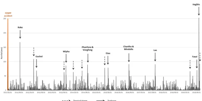
Figure 3 presents the distribution of the mean daily rainfall recorded by 38 stations located within a 100 km radius around the FDNPP between 2011 and 2019. During the investigated period, 16 major tropi-cal storms and typhoons generated extensive rainfall (>60 mm) in the study area, representing an averageFigure 3. Mean rainfall daily amounts measured at the 38 rainfall monitoring stations surrounding FDNPP from the JMA between March 2011 and November 2019. The main typhoons and tropical storms that affected the region during this period are identified by their names on the graph.
of 1.8 heavy rainfall events occurring each year in the region. All the years between 2011 and 2019 experi-enced at least one of these heavy events with the ex-ception of 2018. Only two typhoons generated rain-fall in the FDNPP region that exceeded 150 mm·d−1
after the nuclear accident. The first event (typhoon Roke with a mean rainfall of 168 mm on 21 Septem-ber 2011; range: 55–268 mm) occurred shortly after the nuclear accident. Typhoon Roke generated ex-tensive flooding and radiocesium export in the rivers draining the main Fukushima radioactive plume [Na-gao et al., 2013, Sakuma et al., 2019, Yamashiki et al., 2014].
The second event is typhoon Hagibis, which af-fected the region on 12 October 2019 (mean rainfall of 253 mm; range: 77–558 mm). Hagibis was clearly the event that generated the highest daily rainfall during the entire rainfall sequence recorded between 2011 and 2019. Furthermore, it took place during a partic-ularly wet autumn season; a mean rainfall of 633 mm was recorded in September and October 2019. This is almost the double of what has been recorded on av-erage during these 2 months in the region between 1977 and 2015 [Laceby et al., 016a]. Accordingly, the antecedent rainfall may have weakened soils and
facilitated the landslides and river flooding that oc-curred during typhoon Hagibis.
3.2. Sediment source discrimination and
appor-tionment
Among the 31 potential fingerprint properties mea-sured and retained for analysis (see Figures in Sup-plementary Material S2), only four of them were found not to be conservative (Zr, a∗, h, u0;
Ta-ble 1). Following the KW test, only two properties did not provide significant discrimination among the potential sources (Fe, Co; Table 1). From the 25 retained parameters, a suite of 10 properties (L∗, Ca, Al, a, z, b, b∗, Si, C∗, Ti) was selected by the DFA (Table 2). This tracing suite includes six colorimetric properties and four geochemical ele-ments. One of the color parameters (L∗) represents
the sample brightness [Viscarra Rossel et al., 2006]. Subsurface material containing light-colored granite was logically found to be brighter (mean L∗of 58.6) than the other sources (cropland: 46.0; forest: 35.7) developed on Fluvisols, Andisols, and Cambisols (see Supplementary Material S1). The other selected color properties (a, z, b, b∗, c∗) represent color variations
Olivier Evrard et al. 205
Table 1. Results of the conservative test and the Kruskal–Wallis test on the suite of potential tracers Kruskal–Wallis test Property Conser-vative H -value p-value Discri-minant Mg Yes 11.7 <0.01 Yes Al Yes 35.6 <0.01 Yes Si Yes 27.5 <0.01 Yes K No 16.4 <0.01 Yes Ca Yes 20.6 <0.01 Yes Ti Yes 12.5 <0.01 Yes Mn Yes 11.8 <0.01 Yes Fe Yes 2.3 0.32 No Co Yes 1.0 0.61 No Ni Yes 4.8 0.09 No Cu Yes 6.1 <0.05 Yes Zn Yes 12.9 <0.01 Yes Rb Yes 13.1 <0.01 Yes Sr Yes 20.4 <0.01 Yes Zr No 22.0 <0.01 Yes Pb Yes 2.0 0.37 No L∗ Yes 35.7 <0.01 Yes a∗ No 16.6 <0.01 Yes b∗ Yes 27.0 <0.01 Yes c∗ Yes 25.8 <0.01 Yes h No 27.0 <0.01 Yes x Yes 18.1 <0.01 Yes y Yes 14.2 <0.01 Yes z Yes 16.5 <0.01 Yes L Yes 35.7 <0.01 Yes a Yes 20.2 <0.01 Yes b Yes 29.1 <0.01 Yes u∗ Yes 24.2 <0.01 Yes v∗ Yes 29.0 <0.01 Yes u0 No 8.6 <0.05 Yes v0 Yes 15.6 <0.01 Yes
[Viscarra Rossel et al., 2006] with again differences found in subsurface material tending to be more yel-low (mean b value: 15.5) than cropland (b: 10.0) and forest (b: 7.0) sources.
Table 2. Variables retained by the DFA and as-sociated statistics
Property Wilks lambda p-value
L∗ 0.30011 <0.01 Ca 0.21889 <0.01 Al 0.17844 <0.01 a 0.14342 <0.01 z 0.09318 <0.01 b 0.08679 <0.01 b∗ 0.07259 <0.01 Si 0.06275 <0.01 C∗ 0.05784 <0.01 Ti 0.05365 <0.01
Regarding the selected geochemical properties, Al was found to be the most enriched in subsur-face material (mean: 110,250 mg·kg−1) compared to other sources with mean values ranging between 65,780 mg·kg−1 for forest and 84,730 mg·kg−1 for cropland material. This likely reflects the higher lev-els of gibbsite (aluminum hydroxide) or kaolinite found in subsurface granitic saprolite illuviated from the upper soil depths through soil formation [Nakao et al., 2009]. Ca and Ti are depleted in the subsurface material compared to cultivated and forested land, which is commonly observed in Japanese soils be-cause of leaching and weathering of these elements through the soil profile. In contrast, an enrichment of Si was found in subsurface compared to surface sources [Takeda et al., 2004].
The sediment source contributions calculated by the model (see Supplementary Material S3) show the dominance of cropland (corresponding to the ready-to-cultivate soils) sources in the Mano River catchment (mean: 58%, SD: 29%) followed by forest material (mean: 34%, SD: 18%; Figure 4). In contrast, forest landscapes were the most dominant source in the Niida River catchment (mean: 48%, SD: 22%) fol-lowed by cropland (mean: 44%, SD: 30%). In both catchments, subsurface material supplied compar-atively low contributions (mean 8–9%) to sediment transiting these coastal river systems.
The relatively high SDs associated with the mean source contributions demonstrate the occurrence of large spatial variations across the two investigated catchments. In the upper catchment area, cropland
Figure 4. Modeled sediment source contribu-tions to sediment collected after the October 2019 typhoons in the Niida and Mano River catchments.
was the main sediment source in both the Niida (mean: 57%, SD: 20%) and the Mano River water-sheds (mean: 60%, SD: 25%). Significant forest and subsurface contributions were found locally (Fig-ure 4), mainly in the central part of the Mano River catchment (forest: 60%; subsurface: 40%). In the cen-tral part of the Niida River catchment, sediment sam-ples were even modeled to originate exclusively from forest sources. This is likely explained by the inci-sion of the river in steep woodland areas in this area. Finally, in the coastal plain, the model calcu-lated that a mix of forest (mean: 51%, SD: 23%), crop-land (mean: 31%, SD: 34%), and subsurface (mean: 18%, SD: 24%) sources delivered sediment, which is consistent with the results obtained in upstream sections.
The results from the current research contrast with those obtained in previous studies conducted in the same study areas. Evrard et al. [019a] used color properties to discriminate among cropland, forest, and subsurface source contributions to sediment
collected after major typhoons and spring floods in the same catchments between 2011 and 2017. Although they also found a dominant contribution of cropland (mean: 56%, SD: 34%), subsoil (mean: 26%, SD: 16%) and forests (mean: 21%, SD: 24%) were also reported to provide significant sources of ma-terial to the river systems. Similar results were ob-tained by Laceby et al. [016b], who used organic mat-ter properties to differentiate the sources of sediment delivered to these river systems between 2012 and 2014. They found that the dominant contribution of subsurface sources (mean: 45%, SD: 26%) exceeded those of cropland (mean: 38%, SD: 19%) and forest sources (mean: 17%, SD: 10%). Huon et al. [2018] followed a similar approach on sediment cores col-lected in the Mano Dam reservoir. They also calcu-lated significant sediment contributions from sub-surface (mean: 25%, SD: 4%) and forests (mean: 27%, SD: 6%) despite cropland being quantified to pro-vide the dominant sediment supply to the reservoir (mean: 48%, SD: 7%).
The much lower subsurface contributions (mean: 5%, SD: 11%) found in the current research compared to those quantified in previous studies are likely ex-plained by the fact that landslides occurred after the flood peak and mobilized relatively coarser mate-rial that deposited at the foot of hillslopes or in the major floodplain (Supplementary Material S4). How-ever, this material stored in the vicinity of the river channel will likely be preferentially remobilized dur-ing subsequent flood events. The large dominance of cropland material (mean: 54%, SD: 26%) is likely ex-plained by the low vegetation cover available on most fields that had just been prepared for recultivation (see Supplementary Material S1) as well as by its di-rect connectivity to the river channel [Chartin et al., 2013] mainly during heavy typhoons such as Hagibis [Chartin et al., 2017].
3.3. Radiocesium concentrations in river
sedi-ment
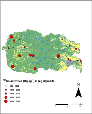
The137Cs activities measured in lag deposits were slightly higher in sediment collected in the Niida River (mean: 2385 Bq·kg−1; SD: 2006 Bq·kg−1; Fig-ure 5) compared to the Mano River (mean: 1877 Bq·kg−1; SD: 1818 Bq·kg−1; Figure 5), which is likely
explained by the fact that the first river drains initially more contaminated soils (Figure 1).
Olivier Evrard et al. 207
Figure 5. Concentrations of137Cs measured in sediment samples collected after the October 2019 typhoons in the Mano and Niida River catchments.
Overall, the extensive soil erosion processes that occurred in the investigated catchments during the 2019 typhoons did not lead to an increase in the137Cs contamination levels in sediment transiting these coastal river systems compared to the previous sam-pling campaigns. The current research demonstrates that the decrease in137Cs activities measured in sed-iment collected between 2011 and 2015 at the same locations [Chartin et al., 2017] continued between 2016 and 2019. Compared to the mean levels ob-served in sediment collected in 2011, this decrease in 137Cs concentrations reached 93% in the Niida River (2385 Bq·kg−1compared to 34,100 Bq·kg−1) and 84% in the Mano River (1877 Bq·kg−1 in 2019
com-pared to 11,900 Bq·kg−1 in 2011). This is likely
ex-plained by the dominance of the decontaminated cropland soil contributions found in these lag de-posits and demonstrated by the sediment finger-printing approach conducted in the current research. The slightly higher137Cs levels measured in sediment samples collected in the coastal reaches of the Niida
River (mean: 2442 Bq·kg−1; maximum: 7559 Bq·kg−1)
remained below the 8000 Bq·kg−1threshold for
con-taminated material being disposed of in conven-tional landfills [Evrard et al., 019c] or close to or below the threshold for material being used to build road embankments [Takai et al., 2018].
3.4. Perspectives
for
regional
recovery
in
Fukushima and for future research
Overall, the results obtained in the current research showed that the heavy rainfall observed during ty-phoons in 2019 did not lead to a renewed increase in
137Cs activity levels in sediment transiting the Mano
and Niida Rivers. Furthermore, our research demon-strated that these concentrations continued to de-crease as documented in rivers draining the main Fukushima radioactive plume since 2011 [Sakuma et al., 2019, Taniguchi et al., 2019, Yoshimura et al., 2015]. The dominant contribution of soils ready for recultivation, providing the main sediment supply in the region, was likely driven by the extensive plow-ing operations conducted in 2019 and the fact that the plowed soils remained temporarily uncovered by vegetation during the 2019 rainy season. This may change in the future as local farmers receive incen-tives from the local authorities to restart agricultural production (e.g., cultivation of flowers, buckwheat, and feed rice) in the area. This will provide a denser cover of the soil by vegetation throughout the year and protect it from erosion. However, the plowing of the residual initial soil profile with the crushed gran-ite layer raises several questions regarding the fertil-ity of these soils and the use of K fertilizers to limit the transfer of the residual137Cs to plants [Kurokawa et al., 2019].
The results obtained in the current research for the Mano and Niida River catchments may not neces-sarily be extended to all the rivers draining the main radioactive pollution plume in Fukushima Prefecture as sediment source contributions depend on local land use and the progress of remediation works at each site. Furthermore, the delineation of restricted access areas and associated rules were modified by recent political decisions. For instance, on 26 August 2020, the Japanese Government lifted the evacuation order in the areas located in the vicinity of the FD-NPP despite the absence of remediation in this zone. However, it may be anticipated that few inhabitants
will return without the implementation of decontam-ination.
The role of forests as a potential perennial supply of sediment and associated137Cs to river systems in this region in general, and in the more densely in-habited coastal areas in particular, remains one of the main challenges for investigation in the future. After complex processes of transfer and migration of137Cs from the canopy, the tree trunk, and the litter to min-eral horizons of soils beneath woodlands [Hashimoto et al., 2020], forests may continue supplying contam-inated material to rivers and ultimately to the Pa-cific Ocean, where137Cs may desorb [Takata et al., 2020] and it may incorporate marine biota or seafloor sediment [Buesseler, 2020]. Accordingly, the reduc-tion in potential downstream transfers of137Cs from forested regions through remediation and/or ongo-ing 137Cs management will likely be an important priority for local inhabitants [Koarashi et al., 2020].
4. Conclusions
The typhoons that occurred in September and Oc-tober 2019, including typhoon Hagibis, triggered ex-tensive erosion and landslides across Japan and the Fukushima-impacted region. They generated wide-spread river flooding, including in the catchments draining the main radioactive plume. Typhoon Hag-ibis was the strongest storm recorded since 2011, and it was the first extreme event that occurred after the completion of decontamination works in agricultural and residential areas. A suite of 10 geochemical and spectrocolorimetric properties with a strong physic-ochemical basis for source discrimination was se-lected to quantify the origin of the material trans-ported in the river systems during this event.
The results obtained using the sediment trac-ing approach developed in the current research demonstrated that sediment mainly originated from decontaminated soils ready for recultivation and forest material, with very limited subsoil contribu-tions, which differs from the results obtained in pre-vious studies. This finding underlines the need to quantify sediment source contributions after con-trasted events as the dominant sources may change depending on the intensity of rainfall events or the magnitude of anthropogenic disturbances (e.g., de-contamination). These results will be particularly helpful to improve our understanding of the main
factors controlling the soil erosion response of these landscapes, which is a prerequisite for designing an effective soil erosion model simulating sediment and contaminant fluxes in this region. The current research also demonstrated that the typhoon did not lead to an increase in137Cs contamination levels recorded in sediment that transited these river sys-tems compared to those recorded during previous years. Furthermore,137Cs concentrations remained systematically below the thresholds allowed for ma-terial to be disposed of in conventional landfills.
In the future, the impact of land recultivation and the perennial contribution of forests to sedi-ment and associated 137Cs delivered to these river systems should continue to be investigated to im-prove our understanding of the consequences of ex-treme events and human disturbances on sediment and contaminant transfers in river networks. The long-term impact of forest landslides, which leads to massive sediment deposition on footslopes, should also be monitored along with the development of re-mediation strategies in woodland ecosystems, which cover approximately 75% of the landscapes in this re-gion.
Acknowledgments
This research was funded by the AMORAD project supported by the French National Research Agency (Agence Nationale de la Recherche [ANR], Pro-gramme des Investissements d’Avenir; grant no. ANR-11-RSNR-0002). The support of Centre National de la Recherche Scientifique (CNRS, France) and Japan Society for the Promotion of Science (JSPS) is also gratefully acknowledged (grant no. PRC CNRS JSPS 2019–2020, no. 10; CNRS International Research Project – IRP – MITATE).
Supplementary data
Supporting information for this article is available on the journal’s website under https://doi.org/10.5802/ crgeos.42 or from the author.
References
Asanuma-Brice, C. (2018). Fukushima, l’impossible retour dans les villages de l’ancienne zone
Olivier Evrard et al. 209
d’évacuation: l’exemple d’Iitate (In French); http://geoconfluences.ens-lyon.fr/actualites/ eclairage/fukushuma-iitate-impossible-retour. Géoconfluences.
Asanuma-Brice, C. (2019). Les catastrophes na-turelles ressuscitent le désastre nucléaire (In French). http://japosphere.blogs.liberation. fr/2019/11/25/les-catastrophes-naturelles-ressuscitent-le-desastre-nucleaire/ (latest ac-cess on 31 August 2020).
Buesseler, K. O. (2020). Opening the floodgates at Fukushima. Science, 369:621–622.
Chartin, C., Evrard, O., Laceby, J. P., Onda, Y., Ottlé, C., Lefèvre, I., and Cerdan, O. (2017). The impact of typhoons on sediment connectivity: lessons learnt from contaminated coastal catchments of the Fukushima Prefecture (Japan). Earth Surf.
Pro-cess. Landf., 42:306–317.
Chartin, C., Evrard, O., Onda, Y., Patin, J., Lefèvre, I., Ottlé, C., Ayrault, S., Lepage, H., and Bonté, P. (2013). Tracking the early dispersion of con-taminated sediment along rivers draining the Fkushima radioactive pollution plume. Anthro-pocene, 1:23–34.
Chino, M., Nakayama, H., Nagai, H., Terada, H., Katata, G., and Yamazawa, H. (2011). Preliminary estimation of release amounts of131I and137Cs ac-cidentally discharged from the Fukushima Daiichi nuclear power plant into the atmosphere. J. Nucl.
Sci. Technol., 48:1129–1134.
CIE, C. (1978). Publication No. 15, Supplement Num-ber 2 (E-1.3.1, 1971): Official Recommendations on Uniform Color Spaces, Color-Difference Equa-tions, and Metric Color Terms. Commission Inter-nationale de L’Eclairage.
CIE, C. U. P. C. (1931). Commission internationale de L’Eclairage Proceedings.
Evrard, O., Chartin, C., Onda, Y., Lepage, H., Cerdan, O., Lefevre, I., and Ayrault, S. (2014). Renewed soil erosion and remobilisation of radioactive sedi-ment in Fukushima coastal rivers after the 2013 ty-phoons. Sci. Rep., 4.
Evrard, O., Durand, R., Foucher, A., Tiecher, T., Sell-ier, V., Onda, Y., Lefèvre, I., Cerdan, O., and Laceby, J. P. (2019a). Using spectrocolourimetry to trace sediment source dynamics in coastal catchments draining the main Fukushima radioactive pollu-tion plume (2011–2017). J. Soils Sedim., 19:3290– 3301.
Evrard, O., Laceby, J. P., Ficetola, G. F., Gielly, L., Huon, S., Lefevre, I., Onda, Y., and Poulenard, J. (2019b). Environmental DNA provides information on sed-iment sources: a study in catchments affected by Fukushima radioactive fallout. Sci. Total Environ., 665:873–881.
Evrard, O., Laceby, J. P., Lepage, H., Onda, Y., Cer-dan, O., and Ayrault, S. (2015). Radiocesium trans-fer from hillslopes to the Pacific Ocean after the Fukushima Nuclear Power Plant accident: a review.
J. Environ. Radioact., 148:92–110.
Evrard, O., Laceby, J. P., and Nakao, A. (2019c). Ef-fectiveness of landscape decontamination follow-ing the Fukushima nuclear accident: a review. Soil, 5:333–350.
Evrard, O., Laceby, J. P., Onda, Y., Wakiyama, Y., Jaegler, H., and Lefevre, I. (2016). Quantifying the dilution of the radiocesium contamination in Fukushima coastal river sediment (2011–2015).
Sci. Rep., 6.
Haddadchi, A., Ryder, D. S., Evrard, O., and Olley, J. (2013). Sediment fingerprinting in fluvial sys-tems: review of tracers, sediment sources and mix-ing models. Internat. J. Sediment. Res., 28:560–578. Hashimoto, S., Imamura, N., Kaneko, S., Komatsu, M., Matsuura, T., Nishina, K., and Ohashi, S. (2020). New predictions of137Cs dynamics in forests after the Fukushima nuclear accident. Sci. Rep., 10. Hashimoto, S., Ugawa, S., Nanko, K., and Shichi, K.
(2012). The total amounts of radioactively contam-inated materials in forests in Fukushima, Japan.
Sci. Rep., 2.
Huon, S., Hayashi, S., Laceby, J. P., Tsuji, H., Onda, Y., and Evrard, O. (2018). Source dynamics of radiocesium-contaminated particulate matter de-posited in an agricultural water reservoir after the Fukushima nuclear accident. Sci. Total Environ., 61:1079–1090.
Irasawa, M., Koi, T., Tsou, C.-Y., Kato, N., Matsuo, S., Arai, M., Kaibori, M., Yamada, T., Kasai, M., and Wakahara, T. (2020). October 2019 Sediment disas-ter in the Tohoku region owing to typhoon no. 19 (Tyhpoon Hagibis). Internat. J. Erosion Control Eng., 13:48–55.
Koarashi, J., Atarashi-Andoh, M., Nishimura, S., and Muto, K. (2020). Effectiveness of decontamination by litter removal in Japanese forest ecosystems af-fected by the Fukushima nuclear accident. Sci. Rep., 10.
Kurikami, H., Funaki, H., Malins, A., Kitamura, A., and Onishi, Y. (2016). Numerical study of sedi-ment and137Cs discharge out of reservoirs during various scale rainfall events. J. Environ. Radioact., 164:73–83.
Kurokawa, K., Nakao, A., Tsukada, H., Mampuku, Y., and Yanai, J. (2019). Exchangeability of137Cs and K in soils of agricultural fields after decontamination in the eastern coastal area of Fukushima. Soil Sci.
Plant Nutrition, 65(4):401–408.
Laceby, J. P., Chartin, C., Evrard, O., Onda, Y., Garcia-Sanchez, L., and Cerdan, O. (2016a). Rainfall erosivity in catchments contaminated with fallout from the Fukushima Daiichi nuclear power plant accident. Hydrol. Earth Syst. Sci., 20:2467–2482. Laceby, J. P., Huon, S., Onda, Y., Vaury, V., and
Evrard, O. (2016b). Do forests represent a long-term source of contaminated particulate matter in the Fukushima Prefecture? J. Environ. Manage., 183:742–753.
Lepage, H., Evrard, O., Onda, Y., Lefevre, I., Laceby, J. P., and Ayrault, S. (2015). Depth distribution of cesium-137 in paddy fields across the Fukushima pollution plume in 2013. J. Environ. Radioact.,
147:157–164.
Lepage, H., Laceby, J. P., Bonté, P., Joron, J.-L., Onda, Y., Lefèvre, I., Ayrault, S., and Evrard, O. (2016). Investigating the source of radiocesium contami-nated sediment in two Fukushima coastal catch-ments with sediment tracing techniques.
Anthro-pocene, 13:57–68.
Nagao, S., Kanamori, M., Ochiai, S., Tomihara, S., Fukushi, K., and Yamamoto, M. (2013). Export of
134Cs and137Cs in the Fukushima river systems at
heavy rains by typhoon Roke in September 2011.
Biogeosciences, 10:6215–6223.
Nakao, A., Funakawa, S., Watanabe, T., and Kosaki, T. (2009). Pedogenic alterations of illitic minerals represented by radiocaesium interception poten-tial in soils with different soil moisture regimes in humid Asia. Eur. J. Soil Sci., 60:139–152.
Nakao, A., Takeda, A., Ogasawara, S., Yanai, J., Sano, O., and Ito, T. (2015). Relationships between paddy soil radiocesium interception potentials and physicochemical properties in Fukushima, Japan. J. Environ. Qual., 44:780–788.
Owens, P. N., Blake, W. H., Gaspar, L., Gateuille, D., Koiter, A. J., Lobb, D. A., Petticrew, E. L., Reiffarth, D. G., Smith, H. G., and Woodward, J. C. (2016).
Fingerprinting and tracing the sources of soils and sediments: earth and ocean science, geoarchaeo-logical, forensic, and human health applications.
Earth Sci. Rev., 162:1–23.
Sakuma, K., Nakanishi, T., Yoshimura, K., Kurikami, H., Nanba, K., and Zheleznyak, M. (2019). A mod-eling approach to estimate the137Cs discharge in rivers from immediately after the Fukushima acci-dent until 2017. J. Environ. Radioact., 208–209. Steinhauser, G., Brandl, A., and Johnson, T. E. (2014).
Comparison of the Chernobyl and Fukushima nu-clear accidents: a review of the environmental im-pacts. Sci. Total Environ., 470–471:800–817. Takai, S., Sawaguchi, T., and Takeda, S. (2018). Dose
estimation in recycling of decontamination soil re-sulting from the Fukushima NPS accident for road embankments. Health Phys., 115:439–447.
Takata, H., Aono, T., Aoyama, M., Inoue, M., Kaeriyama, H., Suzuki, S., Tsuruta, T., Wada, T., and Wakiyama, Y. (2020). Suspended particle-water interactions increase dissolved137Cs activities in the nearshore seawater during typhoon Hagibis.
Environ. Sci. Technol., 54(17):10678–10687.
Takeda, A., Kimura, K., and Yamasaki, S.-i. (2004). Analysis of 57 elements in Japanese soils, with spe-cial reference to soil group and agricultural use.
Geoderma, 119:291–307.
Tamura, T. (1964). Consequences of activity release: selective sorption reactions of cesium with soil minerals. Nucl. Safety, 5:262–268.
Taniguchi, K., Onda, Y., Smith, H. G., Blake, W., Yoshimura, K., Yamashiki, Y., Kuramoto, T., and Saito, K. (2019). Transport and redistribution of radiocesium in Fukushima fallout through rivers.
Environ. Sci. Technol., 53:12339–12347.
Tiecher, T., Ramon, R., Laceby, J. P., Evrard, O., and Minella, J. P. G. (2019). Potential of phosphorus fractions to trace sediment sources in a rural catch-ment of southern Brazil: comparison with the con-ventional approach based on elemental geochem-istry. Geoderma, 337:1067–1076.
Viscarra Rossel, R. A., Minasny, B., Roudier, P., and McBratney, A. B. (2006). Colour space models for soil science. Geoderma, 133:320–337.
Walling, D. E. (2013). The evolution of sediment source fingerprinting investigations in fluvial sys-tems. J. Soils Sedim., 13:1658–1675.
Wilkinson, S., Hancock, G., Bartley, R., Hawdon, A., and Keen, R. (2013). Using sediment tracing to
Olivier Evrard et al. 211
assess processes and spatial patterns of erosion in grazed rangelands, Burdekin River basin, Australia.
Agric. Ecosyst. Environ., 180:90–102.
Yamashiki, Y., Onda, Y., Smith, H. G., Blake, W. H., Wakahara, T., Igarashi, Y., Matsuura, Y., and Yoshimura, K. (2014). Initial flux of sediment-associated radiocesium to the ocean from the largest river impacted by Fukushima Daiichi Nu-clear Power Plant. Sci. Rep., 4.
Yasunari, T. J., Stohl, A., Hayano, R. S., Burkhart, J. F., Eckhardt, S., and Yasunari, T. (2011). Cesium-137 deposition and contamination of Japanese soils due to the Fukushima nuclear accident. Proc. Natl
Acad. Sci. USA, 108:19530–19534.
Yasutaka, T., Naito, W., and Nakanishi, J. (2013). Cost and effectiveness of decontamination strategies in radiation contaminated areas in Fukushima in re-gard to external radiation dose. PLoS One, 8. Yoshimura, K., Onda, Y., Sakaguchi, A., Yamamoto,
M., and Matsuura, Y. (2015). An extensive study of the concentrations of particulate/dissolved ra-diocaesium derived from the Fukushima Dai-ichi Nuclear Power Plant accident in various river sys-tems and their relationship with catchment inven-tory. J. Environ. Radioact., 139:370–378.