HAL Id: halshs-01851595
https://halshs.archives-ouvertes.fr/halshs-01851595
Submitted on 30 Jul 2018HAL is a multi-disciplinary open access archive for the deposit and dissemination of sci-entific research documents, whether they are pub-lished or not. The documents may come from teaching and research institutions in France or abroad, or from public or private research centers.
L’archive ouverte pluridisciplinaire HAL, est destinée au dépôt et à la diffusion de documents scientifiques de niveau recherche, publiés ou non, émanant des établissements d’enseignement et de recherche français ou étrangers, des laboratoires publics ou privés.
uivvaq: a stratified iñupiaq occupation at cape lisburne,
northwest alaska
John Hoffecker, Owen Mason, Scott Elias, Diane Hanson, Claire Alix,
Georgeanne Reynolds, Karlene Leeper
To cite this version:
John Hoffecker, Owen Mason, Scott Elias, Diane Hanson, Claire Alix, et al.. uivvaq: a stratified iñupiaq occupation at cape lisburne, northwest alaska. Alaska Journal of Anthropology, Alaska An-thropological Association, 2012, 10, pp.143-172. �halshs-01851595�
uivvaq
:
a
stratified
iñupiaq
occupation
at
cape
lisburne
,
northwest
alaska
John F. Hoffecker
Institute of Arctic and Alpine Research, University of Colorado, Campus Box 450, Boulder, CO 80305-0450; john.hoffecker@colorado.edu
Owen K. Mason
Institute of Arctic and Alpine Research, University of Colorado, Campus Box 450, Boulder, CO 80305-0450; geoarch85@gmail.com
Scott A. Elias
Department of Geography, Royal Holloway, University of London, Egham, Surrey TW20 0EX United Kingdom; s.elias@rhul.ac.uk
Diane K. Hanson
Department of Anthropology, University of Alaska Anchorage, Anchorage, AK 99508; dkhanson@uaa.alaska.edu
Claire Alix
Archéologie des Amériques, Université de Paris 1, 92023 Nanterre Cedex, France Alaska Quaternary Center, University of Alaska, Fairbanks, AK 99775; cmalix@alaska.edu
Georgeanne L. Reynolds
Tribal Liaison, Directorate of Civil Works, HQ US Army Corps of Engineers, Washington, DC
Karlene Leeper
611th Wing, U.S. Air Force, CES/CEVP, Elmendorf Air Force Base, AK 99506-2270 abSTRacT
The Uivvaq site, near Cape Lisburne in Northwest Alaska, was abandoned in 1950 after its acquisition
by the U.S. Air Force. In 2000 and 2002, reconnaissance archaeological investigations (15 m
2) were
undertaken at one of the surviving mounds. A trench excavation revealed three principal components
dating between ad 950 and 1650, based on a suite of seventeen
14C assays. Paleotemperatures were
estimated from associated beetle remains and correlated with storm stratigraphy. The three
archaeo-logical components include (a) the lowermost (ad 950–1050) associated with Natchuk and Thule II
harpoon heads, succeeded by (b) a middle component (ad 1050–1150) that yielded a Punuk “trident,”
or counterweight, while (c) the uppermost (ad 1300–1600) contained a Thule IIc multibarbed
har-poon head and an Intermediate Kotzebue assemblage.
backgROund TO ThEPROjEcT
The Uivvaq project originated as an exploratory effort to examine a large archaeological mound that had escaped the attentions of subsistence diggers and archaeologists due to its federal impoundment as an Air Force instal-lation for over fifty years. An archaeological survey by Hoffecker (1998) and the cultural resource management
assessment by Reynolds (1989) persuaded the National Science Foundation to support reconnaissance at Uivvaq in 2000. The U.S. Air Force had inadvertently destroyed part of the site in the 1950s and decided in the early 2000s to conduct archaeological mitigation in conjunction with the cleanup of hazardous materials (Mason 2003).
Uivvaq, located in Northwest Alaska, contains a 1- to 2-meter deeply stratified succession of midden deposits and presents a unique opportunity to examine culture and climate change. Uivvaq promised to inform arctic archae-ologists on the causes of major shifts in Northwest Alaska prehistory. Two major stumbling blocks are the scarcity of undisturbed archaeological deposits that are well-stratified and the lack of radiometric dates for the region. Although dendrochronology and horizontal beach-ridge stratigra-phy were crucial in defining chronologies (e.g., Giddings 1952, 1966), due to uneven research priorities many un-certainties remain concerning the temporal relationships and absolute ages of sites and individual occupation hori-zons. By conducting interdisciplinary research at Uivvaq, we are able to provide a millennial record as a preliminary step in such reconstructions.
ThEiPiuTakcOllaPSEandThE
mEdiEvalclimaTEanOmaly
During ad 900 to 1200, Northwest Alaska witnessed drastic changes in climate and human population that had far-reaching consequences for the circumpolar zone of North America (Bockstoce 1973; Mason and Barber 2003; McGhee 1969/70, 1981). The tenth century ad opened with a brief cold oscillation and a sustained interval of in-creased storminess (Mason and Gerlach 1995; Mason and Jordan 1993). However, by the late twelfth century, sum-mer temperatures had significantly warmed, inaugurating the Medieval Climate Anomaly (MCA) (cf. Xoplaki et al. 2011) across the northern hemisphere.
Shifts in the weather associated with the MCA appar-ently upset the political geography of Northwest Alaska and triggered several social and cultural transformations (Bockstoce 1973, 1976; Mason 1998, 2009a, 2009b; Maxwell 1985; McGhee 1969/70, 1981). As one possible correlate, around ad 900 the regionally dominant Ipiutak polity centered at Point Hope disintegrated as its consider-able military and spiritual power dissipated (Mason 1998, 2000, 2006, 2009b). Its demise correlated with climatic shifts, but it is unclear if storm track shifts or warmer or cooler conditions were adverse (Mason and Jordan 1993). The political and economic niche occupied by Ipiutak was subsequently filled after ad 1000 by the Birnirk people, who established a small settlement at Jabbertown, 7 km east of Point Hope (Larsen and Rainey 1948; Mason and Bowers 2009).
Unlike the Ipiutak people, the Birnirk, presumed an-cestors of the Iñupiat (Mason 2009a; Mason and Bowers 2009; Maxwell 1985; Morrison 2001; Stanford 1976), employed a sophisticated technology to hunt bowhead whales from Point Hope and other strategic locations in Northwest Alaska (Bockstoce 1976, 1979; Harritt 1995; Larsen and Rainey 1948; McCartney 1995; Stanford 1976). The mechanism of the subsistence and tech-nological transformations was either passive influence (“trait diffusion”) or direct “invasion” or colonization by both Birnirk and Punuk people from the western side of Bering Strait, who occupied sites along the northern and western coasts of Alaska (Collins 1964; Ford 1959:67; Mason 2009b:94). The conventional climate paradigm proposes that warming increased opportunities for open-water whaling (Bockstoce 1976; McGhee 1969/70). In this scenario, Iñupiaq settlements expanded in size and distribution by the thirteenth century ad and eventually spread across arctic Canada to Greenland (Maxwell 1985; McGhee 1969/70, 1981, 2000). Coupled with the expan-sion of the whaling economy, Bockstoce (1976:42) pos-tulated a broadening of the subsistence base and greater reliance on caribou.
lOcaTiOnandSETTing
The Uivvaq mounds are 3 km east of Cape Lisburne at 68°53' North, 166°08' West along the eastern Chukchi Sea coast of Northwest Alaska. Situated 65 km northeast of Point Hope, Cape Lisburne experiences (1954–1984 baseline) a July mean temperature of 7°C and a January mean of –18°C, although February and March are usually much colder (WRCC n.d.). Annual precipitation averages only 29 cm, with the highest rainfall (7 cm) in August and with about one meter accumulating as snow. Land-fast ice typically forms at the cape and its adjoining coast between October and June (Fig. 1).
Cape Lisburne is a steep and jagged bedrock prom-ontory rising 289 m above sea level that forms the northwest terminus of the Lisburne Hills, composed of Carboniferous limestone and shale interbedded with chert (Collier 1906:16). The abundance of high-quality raw material for stone tool manufacture proved attractive for Uivvaq. Other valuable minerals were available nearby, in-cluding coal and black shale (Burch 1981:34–35; Collier 1906). Cape Lisburne marks an abrupt shift in coastal alignment and represents one of the stormiest locales in
northern Alaska (“a famous wind hole . . . passed safely in a small boat only during fair weather” [Collier 1906:8]). However, Uivvaq was sheltered from westerly winds by the Lisburne Hills and protected from northerly winds by for-mation of a local high-pressure zone at the base of the cliffs (VanStone 1977:67). Oriented west–east, Uivvaq was also protected from the impact of southerly storms along the northern coast by the Lisburne Hills. Recent storm surge events have had only minimal effects on the beach— evidence is lacking for either erosion or beach ridge for-mation (e.g., Kowalik 1984), and modern driftwood is limited to a few medium-sized logs (Alix 2002, field ob-servations). The Alaska coastal current flows northeast at
the cape and subsequently follows a clockwise return flow from Icy Cape (Fleming and Heggarty 1966:705). The southwest counter-current has contributed to sediment accumulation in the form of submarine gravel and sand north of Cape Lisburne (Sharma 1979).
uivvaqaRchaEOlOgy
:
aninTERdiSciPlinaRyaPPROach
Although the Uivvaq middens (XPH-045) were recorded by several archaeological surveys of Cape Lisburne (e.g., Hoffecker 1998; Neakok et al. 1985; Reynolds 1989), no substantive field research (i.e., shovel probes, excavation, or
detailed mapping) had been conducted prior to 2000. NSF funding in 2000 supplemented by a Department of Defense contract in 2002 (Mason 2003) recognized the potential of the deep and relatively undisturbed middens to yield valu-able archaeological data. The resulting project sought an interdisciplinary perspective integrating ethnohistory and traditional knowledge with geology, paleoecology, paleo-climatology, and archaeology. Because of Uivvaq’s historic bond to Tikig.aq (Point Hope), the project was undertak-en in concert with the Elders Advisory Council and the Native Village of Point Hope. Members of the North Slope Borough Commission on Iñupiat History, Language, and Culture (IHLC) also participated in the project.
The research design addressed several issues in the pre-history of Uivvaq: When did occupation of the site begin and by whom? Did subsistence use of the site change in tandem with climate change? How did the sociopoliti-cal relationship between Point Hope and Uivvaq evolve over time, and did their relationship extend back into the Ipiutak phase, i.e., prior to ad 900? What was Uivvaq’s relationship to sites across Northwest Alaska and in Chukotka? Hopefully, the archaeological study of Uivvaq could shed light on broader issues, for example, the emer-gence of the Thule culture and a whaling economy.
Data about Uivvaq’s recent past were compiled from several sources, including archived oral history recordings (e.g., Reynolds 1989) and historical accounts (e.g., Burch 1981; Lowenstein 1981, 2009; VanStone 1962). In addi-tion, IHLC staff conducted new oral history interviews with Point Hope elders (Mason 2003). As a consequence, the modern history of Uivvaq provides a cultural context for the investigation of its remote prehistory.
uivvaqhiSTORy
: 1800–2000
Two hundred years ago, Uivvaq was part of a Tikig.ag.miut polity that controlled 10,000 km2 across Northwest
Alaska, as reconstructed from Native informants by Burch (1981, 1998). Although described as a “tribe” by Ray (1975), in Iñupiaq the terminology is similar to a na-tion or “city” state (Burch 1998:8–12). Around ad 1800, the Tikig.ag.miut nation extended from 25 km below Cape Thompson in the south to near Cape Beaufort in the north. As many as 1,300 people resided within the borders of the Tikig.ag.miut, according to Burch (1981:11–14). The large settlement at Tikig.aq served as the social and spiri-tual hub of the Tikig.ag.miut—and the winter residence of over half the population (Foote 1992; Rainey 1947).
Uivvaq, despite its small size, was the second most important winter settlement within the nunatqatigiit and was the only other place to conduct a spring bowhead whale hunt (Burch 1981:37–42). Uivvaq (or “coming around the point”) specifically refers to Cape Lisburne, but served as shorthand for the adjacent village named
Uivaum Initugliat (Neakok et al. 1985:41). Although the
population of Uivvaq declined significantly in the nine-teenth century, its numbers were never substantial. Burch (1981:14) inferred that only about seventy people inhab-ited Uivvaq prior to the intrusion of Euro-Americans ca. ad 1850. Even this estimate could be high, consider-ing that the Russian explorer A. F. Kashevarov visited the village in July 1838 and counted only twenty people (VanStone 1977:20). However, a major battle had just occurred near Cape Lisburne (Burch 2005:272–273), and very likely the families at Uivvaq were still recover-ing from that catastrophe.
The spring bowhead whale hunt at Uivvaq differed from that at Tikig.aq (Lowenstein 1981:62ff; Rainey 1947:257–263). The number of crews was smaller, of course, perhaps only one or two, with eight men each. Crews were positioned on landfast ice one kilometer north of the cape along the margin of a recurring shore lead. On occasion, Uivvaq whalers intercepted and killed escaped bowheads wounded by whalers at Point Hope (Burch 1981:24–25). With its small population, the Uivvaq community (Fig. 2) probably also conducted less elaborate ceremonial feasting, as compared with the re-gional center at Tikig.aq.
Uivvaq’s primary appeal for its inhabitants lay in its variety of food sources, several terrestrial in origin, especially mountain sheep and birds, with access to nearby caribou (Burch 1981:56, Lowenstein 1981:74). Like most coastal locales, walrus were typically available during the early summer and fall, while beluga whales appeared in the spring and summer (Burch 1981:69). Small seals were hunted throughout the year, although not all three spe-cies (e.g., ringed seal or natchuq) were reliably present, due to turbulent seas (Lowenstein 1981:16). Polar bears were commonly encountered (Lowenstein 1981:40). On land, Uivvaq people hunted caribou, sheep, bear, and foxes, subject to seasonal availability. Birds nested in the cliffs around the cape in the thousands, and their eggs were collected from rock ledges in July (Burch 1981:26–32).
During the nineteenth century, the population of the Tikig.ag.miut nation underwent a nearly catastrophic decline, due to the consequences of internecine warfare
(Burch 1981, 2005), resource collapse (Burch 2012), and the appearance of outsiders bearing infectious disease, alcohol, and firearms (Lowenstein 2009). Between 1800 and 1840, Point Hope clashed with neighboring nations in three battles that cost many lives and shifted the region-al bregion-alance of power against Tikig.aq (Burch 2005:111ff). Around 1800, a conflict with Noatak and Kivalina people forced the Tikig.ag.miut (Burch 1981:14) to cede territory as far south as Kivalina (VanStone 1962:19). Shortly thereaf-ter, another sizable Tikig.ag.miut community, Nuvuraluaq, was attacked by Dihai Gwich’in from the upper Noatak (Burch 1981:14–15, 2005:111ff). For Uivvaq, a battle in the late 1830s was devastating; it occurred just southwest of the site and its aftermath was described by Kashevarov (Burch 1981:15, 2005:272; VanStone 1977:54): “human bones strewn everywhere and . . . bodies that had not yet decomposed.” This attack involved the Qiqiqtarzurmiut, people from modern-day Kotzebue; the population of
Uivvaq was nearly decimated (Burch 1981:14–15). The presence of Russian traders at Bering Strait did lead to a precipitous decline in internecine warfare (Burch 2005:233).
Despite the cessation of warfare, the decades following 1850 were marked by population declines in Tikig.aq and Uivvaq and by collapse of the whaling economy associated with commercial whaling in the Chukchi Sea (Bockstoce 1986; Burch 1981; Lowenstein 2009). The whale and walrus populations were significantly depleted by 1870 (Bockstoce 1986), a catastrophe coupled with the inadver-tent introduction of several infectious diseases. One of the first, a measles epidemic in 1865, reportedly caused hun-dreds of deaths (Burch 1981:15). A subsequent smallpox outbreak in 1900 is termed the “Great Sickness” and led to further population decline (Lowenstein 2009:235ff). Dire effects, possibly climatic, also affected crucial subsistence resources. By 1870, the Uivvaq whale hunt had ceased
Figure 2. The village of Uivvaq, photographed by Alfred M. Bailey in March 1922. Image Archives, Denver Museum of Nature and Science (cat. no. IV.BA21-033.P).
and by 1880, the U.S. Census recorded only thirteen resi-dents, representing one or two families, although many more people visited the cliffs of the cape to collect murre eggs (Lowenstein 1981:74ff; VanStone 1962:62). The re-gional collapse of the Western Arctic caribou herd (Burch 2012:83ff) also led to famine in Point Hope in the winter of 1885–1886, and by 1905 the entire Tikig.ag.miut nation was reduced to less than 200 people (Burch 1981:15–21; Foote and Williamson 1966:1046–1048; Lowenstein 2009:235).1
An increase in population at Uivvaq after 1910 re-flected an economic upturn driven by the resurgent world market for furs, especially the locally abundant arctic fox (Burch 1981:19; Rainey 1947:281). However, when the fur market collapsed with the onset of the Great Depression, permanent residency at Uivvaq declined. Several families remained at the site until 1950, and accounts by Point Hope elders for this project (cf. Mason 2003) record vil-lage life during the first half of the twentieth century.
In 1950, the U.S. Air Force constructed a radar sta-tion at Cape Lisburne as part of the Aircraft Control and Warning (AC&W) network (VanStone 1962:61). The net-work was intended to provide early warning of trespass by Soviet aircraft. The radar was emplaced on the cape summit and support facilities were erected below, 1.5 km east of Uivvaq village, although the airstrip was immedi-ately adjacent. During construction of the airstrip, several abandoned sod houses were destroyed (roughly half of the former village), but two large middens remained intact. Possibly, the presence of the Air Force installation pro-tected the surviving midden by inhibiting subsistence dig-ging, a common and long-standing practice in communi-ties across Northwest Alaska from Point Hope to Barrow (cf. Ford 1959; Larsen and Rainey 1948).
ThE aRchaEOlOgy Of uivvaq
A principal objective of the Uivvaq project was the docu-mentation of an undisturbed sequence of occupations to obtain a high-resolution record within a well-dated strati-graphic framework. With exceptions (e.g., Tikig.aq [Larsen and Rainey 1948] or Walakpa [Stanford 1976]), deep and stratified multioccupation sequences are rare in northern Alaska, especially those from the Birnirk to Thule transi-tion. Excavation focused on the midden periphery (Fig. 3) to avoid the disruptions resulting from a superimposed series of house constructions and burials in the midden’s center (cf. Ford 1959; Reynolds 1995). Mound margins, by
contrast, offer greater potential for sequence stratigraphy (e.g., Ford 1959:36–37; Rosen 1986:19). This approach was largely successful, but the uppermost deposits of the midden periphery had been disturbed by the excavation of several cache pits during a late occupation, as described below (Fig. 4).
The site was excavated in 5-cm arbitrary levels. All excavated sediment was sieved through fine mesh (⅛ in.) screens employing pressure hoses, available at the DEW-line facility, which maximized the recovery of small ob-jects. Water screening yielded tiny jet beads largely un-known from other north Alaska sites of comparable age, amber beads and fragments, and substantial quantities of small lithic waste flakes. Water sieving also increased the recovery of smaller pottery fragments, which may be difficult to distinguish from the sedimentary matrix in a coarse midden deposit. In 2002, random sediment sam-ples from each unit and level were water-screened for small fragments of wood and charcoal, providing data on wood technology and fuel use.
chROnOlOgicaland
PalEOclimaTic REcOnSTRucTiOnS
RadiOcaRbOnchROnOlOgy
Radiocarbon dates (n = 17) were obtained from a range of materials excavated in stratigraphic context from the midden deposits (Table 1). These 14C assays were
supple-mented by tree-ring analysis of structural wood. Six beetle chitin macrofossils, identified by Elias, were assayed by the University of Colorado radiocarbon laboratory (CURL) with a further eleven radiocarbon samples measured by Beta Analytic on phocid seal (n = 2), walrus (n = 1), caribou (n = 1), and wood macrofossils (willow [Salix spp.], n = 3; spruce [Picea spp.], n = 1), identified by Alix.
Overall, the corpus of seventeen 14C ages was
strati-graphically consistent, albeit with several nonsystematic departures. Insect remains were initially expected to pro-vide the most reliable basis for the chronology of Uivvaq occupation. Because the AMS radiocarbon technique al-lows the assay of exceedingly small samples, chitin from insect exoskeletons offers an alternative to bone and is generally less susceptible to younger carbon contamina-tion. However, the dating of insect remains at Uivvaq re-vealed unexpected ambiguities: Several dates were anoma-lously old given their stratigraphic position and the other dates, including the other insect assays. For example, the
Lab Number Conventional
14C Age bp
Calendar Age ad 13/12C
(‰) Stratigraphic Context DiagnosticsCultural Material Dated
Beta-173868 260 ± 40 1520–1590, 1620–1670, 1770–1800,
1940–1950
–24.7 N15 E1
(42–47 cm bs) IntermediateKotzebue Salix wood and charcoal Beta-173867 330 ± 40 1460–1650 –27.7 N15 E1
(57–62 cm bs) IntermediateKotzebue Salix wood Beta-173869 390 ± 40 1430–1530,
1550–1630 –22.5 N13 E1 N wall (70–84 cm bs) IntermediateKotzebue Adzed timber; outer ring, Picea sp. CURL-6927 470 ± 30 1410–1454 –25.9 N13 E0 E wall
(25–30 cm bd) Intermediate Kotzebue Beetle exoskeleton Beta-174356 610 ± 70 1270–1430
corrected by Beta –19.0 (41 cm bd of N13 E2) N12 E1 Seal (Phoca hispida) pelvis CURL-5767 785 ± 65 1153–1306 –24.63 N13 E0 E wall
(35–40 cm bs) Beetle exoskeleton from bulk sample Beta-173866 840 ± 40 1060–1080,
1150–1270 –24.6 (57–62 cm bs)N13 E1 Salix charcoal CURL-6928 960 ± 35 1016–1162 –25.5 N13 E0 E wall
(50–55 cm bd) Beetle exoskeleton CURL-5947 1010 ± 35 980–1153 –25.0
(est.) N13 E0 E wall (65–70 cm bs) Punuk counter-weight above, at –67 cm
Beetle exoskeleton from bulk sample Beta-174357 1210 ± 60 1060–1300 –12.0 N12 E1
(41 cm bd of N13 E2) Caribou tibia fragment Beta-174355 1340 ± 70 1342–1664,*
1502–2002** –13.3 (51 cm bd of N13 E2)N12 E1 Seal (Phoca hispida) tibia Beta-174354 1410 ± 60 1311–1554,*
1465–1808** –13.7 (43 cm bd)N13 E2 Walrus skull fragment
CURL-6929 1620 ± 30 384–536 –25.7 N13 E0
(70–75 cm bs) Punuk counter-weight above, at –67 cm
Beetle exoskeleton CURL-5438 1390 ± 35 598–691 –23.4 N13 E0 E wall
(95–100 cm bs) Natchuk harpoon head; Thule 2 harpoon head; human figure
Beetle exoskeleton from bulk sample
Beta-180330 1020 ± 40 975–1041 –28.1 N13 E1 (97–102 cm bd) Salix twigs Beta-180816 980 ± 40 987–1160 –26.3 N13 E1 (114 cm bd) Salix charcoal Beta-180331 870 ± 40 1036–1261 –28.6 N13 E1 (112–117 cm bd) Salix twigs
* 510 ± 57 marine reservoir correction
** 720 ± 53 marine reservoir correction (Dumond and Griffin 2002) bs = below surface
bd = below datum
oldest age from Uivvaq was a beetle assay of 1620 ± 30 bp (CURL-6929) at 70–75 cm below surface, nearly 40 cm
above a younger beetle age of 1390 ± 35 bp. The
anoma-lously old beetle ages may have resulted from (a) the inges-tion of old carbon by the beetles; (b) storm redeposiinges-tion of underlying older midden not reached by this project; (c) post-depositional digging by the beetles or (d) by people; or (e) upward displacement of beetle parts due to frost ac-tion. Upward displacement is unlikely as no evidence of cryogenic processes was apparent in the stratigraphy. Of these possibilities, human agency is the most likely, con-sidering that people could have inadvertently redeposited older sediments containing insect remains in younger layers through the periodic cleaning of house interiors (Reynolds 1995:142–144).
Another source of dating uncertainty at Uivvaq might be the three bone assays: Two on marine mammals and one on caribou are possibly problematic. All three had el-evated ∂ 13C values (–12 to –19‰), widely considered to
indicate marine or anomalously old carbon. However, by employing the regional marine carbon offset of 512 ± 57 years proposed by Dumond and Griffin (2002), the seal, walrus, and caribou assays do accord reasonably well with the wood or charcoal ages. Nonetheless, one seal pelvis dated to 610 ± 70 bp (Beta-174356) cannot be reliably cali-brated since its age would be essentially modern.
To interpret the anomalous ages from the insects and adjusted sea mammal assays, we favor a greater reliance on the ages of the short-lived Salix macrofossils. From this perspective, the lower half of the Uivvaq midden was deposited in the eleventh to twelfth centuries ad, adding 50 cm within over twenty discrete storm beds. At its upper end, an angular disconformity, the leading edge of a cul-tural pit, delineates the upper component from the lower. The 14C ages of the upper midden are generally
concor-dant: e.g., the beetle age of 470 ± 30 bp (CURL-6927) is only slightly older, at ad 1410–1454, than an assay on short-lived Salix of 330 ± 40 bp (Beta-173867),calibrated to ad 1460–1650 (Beta-173867).
climaTEREcOnSTRucTiOn
fROminSEcTmacROfOSSilS
A local climate history for Uivvaq was reconstructed with insect macrofossils (especially Coleoptera) recovered in stratigraphic context within the midden. Radiocarbon-dated beetle exoskeletons allow paleotemperature esti-mates through the application of the Mutual Climatic
Range (MCR) method (Elias 1994:74–79). Direct dating of six chitin fragments (Table 1) produced a paleotem-perature curve (Fig. 5) that offers a first approximation for Northwest Alaska (Elias 2003). The MCR tempera-ture estimates derived from the samples were corrected to account for previously observed effects of arctic coastal settings (Elias et al. 1999) and were complemented by observations on midden sediments (e.g., texture, organ-ic matter), whorgan-ich also reflect variations in climate. The MCR and 14C dated insect remains provide an alternative
to employing hemispheric models of climate history that are often out of phase with northern Alaska (Mason and Gerlach 1995:102).
middEnSTRaTigRaPhy
,
culTuREchROnOlOgy,
andclimaTEhiSTORyField research for the project started in 20002 with the
ex-cavation of a trench (1 x 7 m) into the smaller of the two major surviving midden mounds at Uivvaq, designated Mound 2 (Fig. 3). Mound 2 occupies an area of 15 x 20 m and has an apparent elevation of 1.5 m above the present ground, although its subsurface extent is unknown. The 2000 trench was expanded in 2002, to a total of 15 m2.
Several smaller test units (1–2 m2) were also excavated
in other areas during 2000 to characterize the site, and a small trench (1 x 3 m) was opened up on the larger midden (Mound 1) in 2002 but excavated only to shallow depth due to time constraints (Fig. 4).
By definition, archaeological middens are the result of a complex interplay of natural and cultural forma-tion processes (Butzer 1982:87–93; Rosen 1986; Waters 1992). Most midden investigations have occurred in tem-perate or arid environments, including shell middens of the Northwest Coast (Stein 1992); a modern systematic study of midden formation in an arctic coastal setting, where cold climate is a factor, has yet to be undertaken. Potentially significant for interpreting the stratigraphy and chronology of an arctic midden is the interaction between frost activity (e.g., frost heaving, cryoturbation) and hu-man ground disturbance and house construction (Hall n.d.; Reynolds 1995).
Mound 2 at Uivvaq accumulated over several peri-ods during the last 1000 years, the result of four major formation processes (cf. Waters 1992): (1) the onshore deposition of sand and gravel during storms, (2) eolian de-position of sand during high wind events, (3) organic decay and downward movement of silt through beach gravels due
to soil weathering, and (4) purposeful and inadvertent dis-card behavior and ground disturbance by humans (i.e., pit cut and fill). Slope processes apparently played a negligible role in midden sediment accumulation. Seven principal stratigraphic units were defined in Mound 2 and a sum-mary description of each is presented below, from the bot-tom up (Table 2). Depth measurements were from the sur-face in the highest excavation unit, N13 E0. Excavations in both 2000 and 2002 ceased before firmly establishing the base of the midden by reaching culturally sterile deposits, so total depth remains uncertain. Mound 2 could include Ipiutak or earlier occupations, such as Choris, Norton, or possibly Denbigh.
The lithostratigraphy of Uivvaq is divisible into seven depositional units, defined by granulometry, sedimentary structures, and color, as detailed in Table 2. Geological strata were defined by Arabic numbers bottom to top,
whereas cultural stratigraphy was defined by Roman nu-merals. The five lowermost lithostratigraphic units, 1 to 5, resulted predominantly from periodic storm overwash overprinted by cultural practices. Evidence of any modi-fications for architecture or cache pits is negligible in the lower levels. By contrast, the uppermost lithostratigraphic units, 6 and 7, lack visually discernible internal strata. The lower stratigraphic contacts of units 6 and 7 represent an unconformable truncation of the earlier storm sequence due to pit excavation by site residents.
Unit 1 represents a sequence of storm gravels mark-ing seven discrete events, interstratified with debris pro-duced by human occupation. Unit 1 contained three strata with cultural material (Ia, Ib, and II) that were associated with thin beds (≤ 1 cm thick) of compressed organic material and exhibit sharp upper contacts. Dated beetle remains from the base of the unit indicate
BIRNIRK Unit 1, 95 to 115 cm bs • A.D. 598-691 CURL-5438 • A.D. 975-1041 Beta-180330 • A.D. 987-1160 Beta-180816 • A.D. 1036-161 Beta-180331 INTERMEDIATE KOTZEBUE Unit 7, 25 to 45 cm bs • A.D. 1410-1454 CURL-6927 • A.D. 1270-1430 Beta-174356 • A.D. 1153-1306 CURL-5767 • A.D. 1520-1590, 1620-1670, 1770-1800, 1940-1950 Beta-173868 PUNUK Units 3 & 4, 55 to 70 cm bs • A.D. 1060-1080, 1150-1270 Beta-173866 • A.D. 1016-1162 CURL-6928 • A.D. 980-1153 CURL-5947 • A.D. 384-536 CURL-6929
INTERMEDIATE KOTZEBUE, Unit 7a, end ring:
A.D. 1430–1530, 1550–1630 Beta-173869
1
2
3
4
5
7a
7b
7c
Intermediate KotzebueUnit 7a (outer ring of spruce timber) ad 1430–1530, 1550–1630 (Beta-173869) Punuk Units 3, 4 (55–70 cm bs) • ad 1060–1080, 1150–1270 (Beta-173866) • ad 1016–1162 (CURL-6928) • ad 980–1153 (CURL-5947) • ad 384–536 (CURL-6929) Birnirk Unit 1 (95–115 cm bs) • ad 598–691 (CURL-5438) • ad 975–1041 (Beta-180330) • ad 987–1160 (Beta-180816) • ad 1036–161 (Beta-180331) Intermediate Kotzebue Unit 7 (30–0 cm bs) • ad 1410–1454 (CURL-6927) • ad 1270–1430 (Beta-174356) • ad 1153–1306 (CURL-5767) • ad 1520–1590, 1620–1670, 1770–1800, 1940–1950 (Beta-173868)
cool weather. However, this material is likely out of con-text and its climatic significance is problematic, since younger insect samples yielded MCR temperature esti-mates that reflect gradual warming (Fig. 5). Although one assay on insect chitin suggests an earlier age, most radiocarbon dates from this layer indicate a calibrated age between ad 950 and 1000 (Table 1).
In Unit 2, storms were less intense, as indicated from smaller clast size (Table 2). Cultural materials occur within discrete lenses of fire-cracked rock and bone frag-ments—including a bowhead whale bone—ca. 100 cm below surface. While Unit 2 gravels resulted from re-peated storms, the silt likely accumulated due to human occupation, producing Cultural Level III. MCR tempera-ture estimates derived from the analysis of beetle remains reflect a warming trend as much as 1.7°C warmer than previously during the summer months. The layer is not dated directly, but bracketing ages lead to an inferred age between ad 1000 and 1100.
The alternation in storm intensity is reflected in the contrasts between Units 3 and 4. The lower portion of Unit 3 reflects a period of fewer storms, as recorded in the occasional sand and gravel beds. In general, the massive silt beds accumulated as a result of onshore wind, prob-ably during the winter months. The layer is not dated di-rectly, but apparently antedates ad 1100. By contrast, Unit 4 marks a return to stormy conditions that characterized the deposition of Units 1 and 2 and contains some of the largest clasts in the midden sequence, a circumstance that indicates particularly violent storms. Cultural Level V is associated with these stormy conditions. Temperature es-timates based on samples of beetle remains suggest a series of rapid small-scale oscillations (within +1°C of the mod-ern summer mean). Radiocarbon dates indicate an age in the eleventh century ad.
Unit 5 consists of several sand beds, of only limited preservation across the site, with Cultural Level VI at the base of this layer, which separates it from underlying
Table 2. Lithostratigraphy of Uivvaq Mound 2.
Elevations refer to depth below surface of grid square N13 E1.
Unit 1 (>130 to 110 cm below surface): The lowermost excavated layer; broadly level with the present-day ground surface surrounding the midden. Very dark brown (10 YR 2/2), poorly sorted, coarse and medium sand and silt with a sig-nificant percentage of small pebbles (1–2 cm).
Unit 2 (110–90 cm bs): Coarse angular gravel within a silt matrix; the largest clasts are rounded and only 1 to 2 cm in diameter. Upper and lower contacts defined by thick organic-rich silt beds 1 to 2 cm thick.
Unit 3 (90–75 cm bs): Series of massive silt beds with a small sand fraction that alternates with thin laminae of medium to coarse sand and granules. Highly clayey silt is present in the lower portion of the unit. A thick occupation horizon (Cultural Level IV) at the top serves as a contact with overlying Unit 4. Several discrete lenses (>1 cm thick) of coarse to very coarse sand and granules extend seaward towards the center of the midden.
Unit 4 (75–50 cm bs): Complex internal microstratigraphy containing six very dark brown (10 YR 2/2) beds of pebbly sands and granules separated by silt beds (1 to 2 cm thick) with occasional dense lenses filled with oblong pebbles, some >3 cm.
Unit 5 (50–25 cm bs): Six thin sand beds that alternate with dark, compact silt horizons; contains a high percentage of organics. Sharp contacts between the beds. The unit is only minimally observable in the eastern part of the trench due to post-depositional disturbance. Cultural Level VI lies at the base of this layer, which separates it from underly-ing Unit 4.
Unit 6 (50–0 cm bs): Massive fine to medium sand with numerous cobbles (10–15 cm) and fire-cracked rocks (7–10 cm). The unit is discomformable, cutting through several older units, primarily Unit 5. Larger clasts are more common in the lowermost 15 to 20 cm of the unit.
Unit 7 (30–0 cm bs): Uppermost portion of the midden is a poorly sorted dark brown (7.5 YR 3/4) silt with a minor fraction of sand and granules. Cobbles measuring up to 15 cm occur in a discrete zone (Unit 7d) about 50 cm below surface. Unit 7 represents cultural fill of a pit excavated into older deposits.
presence of industrial goods (e.g., iron nails, stove parts) in the uppermost unit suggests that a younger occupation (post-1800) also occurred.
uivvaq culTuRE hiSTORy
:
ad950–1600
Uivvaq was first occupied at least 1000 years ago, dis-counting the problematic sixth century ad radiocarbon age on insect remains. An age estimate within the tenth or eleventh centuries was younger than expected, because the depth of the midden and the apparent stability of the coastline suggested that the occupation of Uivvaq might span two thousand years. Nonetheless, the midden accu-mulated rather rapidly, resulting from closely spaced inter-vals of storm deposition.
Buried artifacts and faunal remains in the Mound 2 sequence are concentrated in dark brown organic-rich beds. These interstratified beds vary in coarseness (often including pea and larger gravel) and were derived from storm events. Sand and silt were deposited by wind action. The pattern does not reflect the long-term occupation and abandonment of Uivvaq, but rather the annual and decadal processes of midden formation. The storm and wind deposits accumulated rapidly, in contrast to the lev-els with concentrations of cultural debris, which represent
Radiocarbon years before present
1000 BP 500 BP Punuk -6 -4 -2 0 +2 +4 +6 +8 -3 -2 -1 0 +1 +2 100 90 80 70 60 50 40 30 20 10 Depth (cm)
Punuk Modern Departure from
TMAX (C) Departure from Modern TMAX (C) Intermediate Kotzebue Intermediate Kotzebue -3 -2 -1 0 +1 +2 Punuk Departure from Modern TMAX (C)
Radiocarbon years before present
1000 BP 500 BP Intermediate Kotzebue 100 90 80 70 60 50 40 30 20 10 TMAX TMAX
Figure 5. Paleotemperature estimates (TMAX °C) based on MCR analysis of beetle remains by S. A. Elias.
Unit 4. The thin sand beds of Unit 5 represent onshore winds that lofted beach sand on land, very likely during winter; the age of the unit can be bracketed to the twelfth century ad by 14C assays on upper and lower deposits.
The poorly sorted matrix of Unit 6 represents the fill of a series of intrusive pits, which—for reasons that are unclear—were excavated into the slope of the midden. The cultural fill within the pits was likely obtained either from the nearby beach or unoccupied parts of the mid-den. While some samples sieved for beetle remains from this layer yielded no specimens, others produced tempera-ture estimates that suggest continued mild climates. Two radiocarbon dates, one on insect chitin, indicate the age of Unit 6 falls in the mid-twelfth to thirteenth centuries (Table 1).
The uppermost Unit 7 rests disconformably atop un-derlying sediments and represents the purposeful horizon-tal arrangement of wood and sod blocks by site residents. The uppermost sample of beetle remains, recovered from the top 15 cm of the unit, yielded the lowest temperature estimates of the Uivvaq sequence (3°C below modern mean summer temperature), corresponding to the cool-ing associated with the Little Ice Age (Fig. 5). Four radio-carbon dates, one on insect chitin, from Unit 7 provide a calibrated date between ad 1470 and 1640. However, the
stable living surfaces of variable duration from months to years, sometimes in conjunction with limited soil forma-tion. Only one possible hiatus in occupation was identi-fied—between the middle and upper components—and this may simply reflect the limited area excavated so far, combined with the effects of disturbance on the deposi-tional units (6 and 7) forming the upper component.
Three broad archaeological components, “lower,” “middle,” and “upper,” are defined within the Uivvaq mid-den sequence, described below. Each component includes one or more cultural levels, designated using Roman nu-merals; these levels do not necessarily represent distinct cultural phases. Levels were defined by both natural levels and in arbitrary 10 cm excavation levels. Although each component yielded one or more diagnostic items (e.g., Natchuk harpoon head) that probably reflect temporal phases in Thule prehistory (e.g., Jensen 2007; Stanford 1976), the overall pattern revealed by Mound 2 reflects cultural continuity that prevails across northern Alaska (cf. Stanford 1976).
Off
-
mOundTESTing,
PRE-
ad950
A small, off-mound test excavation in 2000 uncovered traces of occupation in beach sediments inferred as strati-graphically underlying the midden. The test unit (N38–39 E20) was located 15 m northeast of Mound 2 and yielded artifacts and associated mammal remains at 45 cm below the surface in an organic-rich horizon. Among the arti-facts recovered was a gray chert stemmed knife similar to specimens recovered from the Birnirk site (Ford 1959:166– 170). The undated occupation horizon buried in the beach deposits may precede the lowest unit in Mound 2.
lOwERcOmPOnEnT
(
ad950–1050)
The lower component of Mound 2 comprises cultural lev-els I to III within lithostratigraphic units 1 and 2 and dates between ad 950 and 1050, a relatively stormy cen-tury. The lower component marks the transition from the Birnirk to the Thule culture, dated to the eleventh cen-tury ad across northern Alaska (Anderson 1984:91–92; Mason 2000; Mason and Bowers 2009; Morrison 2001). Diagnostic artifacts in the lower component fall within late Birnirk and/or early Thule phases (Fig. 6), following Ford (1959:83, 86) and Stanford (1976:18ff), based on an antler Natchuk harpoon head (00-889) and the incom-plete basal section of an ivory Thule 2 (or Thule II)
har-poon head (00-1029). The Natchuk sealing harhar-poon head is diagnostic of the Birnirk–Thule transition, according to Morrison (2001:80). Significantly, its inferred age at Uivvaq, during the eleventh century ad, is concordant with similar 14C assays from Jabbertown and Deering
(Mason and Bowers 2009) as well as at Birnirk (Morrison 2001:80). Other Birnirk objects include a bone float noz-zle (00-886) that resembles the wooden pieces found at the Birnirk site (Ford 1959:101–105) and an antler arrow-head, often considered diagnostic of the Birnirk–Thule transition, that has a shoulder-less base with a tapering tang (00-1025) (e.g., Ford 1959:128; Larsen and Rainey 1948:169–173; Stanford 1976:33 [Type I]). A similar ta-pering but bulbous tanged arrowhead from Jabbertown was carved in the eleventh century ad (Mason and Bowers 2009:31). Such tanged antler points were used for sev-eral centuries, based on the sixteenth-century AMS date on one recovered at Cape Denbigh, far south of Uivvaq (Murray et al. 2003:98–100).
Fishing equipment at Uivvaq reflects both jigging and spearing efforts. Several leister prongs were recovered from the upper component, including a slender multibarbed form (Fig. 6; 02-1735). A twin-barbed fishhook for tom-cod (Fig. 6; 02-1724) is identical to one from Qitchauvik in Norton Sound dated to ad 500–600 (Mason et al. 2007: plate IV a, c) but also has similarities to specimens from Kotzebue that are considerably younger, ca. ad 1500 (Giddings 1952: pl. 36).
Two bola weights recovered at Uivvaq (Fig. 7) show af-finities with both Birnirk and later Thule assemblages (for typology, see Ford [1959:139–141]). Typically “found only in Birnirk” (Ford 1959:141) is a Type G bola, an oval ivory piece from the middle component (02-648). An ivory bola weight of subspherical form with two holes drilled at one end (02-1611) corresponds to Class E of Ford (1959:139– 141) and occurs in both early and late contexts, although precise age estimates are rare from elsewhere. A perforated bone (02-555) from the upper component (27–32 cm bd, N13 E1) may be a bola. Rudenko (1961:pl. 30) identifies similar Punuk objects from Sireniki as amulets.
The majority of the artifacts recovered from all three components are debris produced by the manufacture and resharpening of chipped stone tools. In this respect, Uivvaq seems unique among Thule sites, which have yielded only negligible or modest quantities of lithic de-bris (e.g., Stanford 1976:68). The abundance of lithic waste in Mound 2 is a function of the local availability of high-quality flaking stone, combined with the sieving
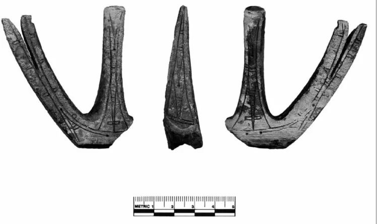
Figure 6. Diagnostic subsistence equipment from Uivvaq. From upper component: closed socket toggling harpoon head with no parallel in the region (upper left; 250); open socket multibarbed Thule IIc harpoon head (upper right; 02-909); leister prong (middle right; 02-1735); swivel for dog line (lower right; 02-1610). From lower component: Natchuk harpoon head (middle left; 00-889); Thule 2 harpoon head base (center; 00-1029); tomcod fish hook (lower left; 02-1724); miniature wooden bow fragment (lower center; 02-1561).
Figure 7. Decorative, fishing, and birding implements from Uivvaq. Top: Antler object of unknown function, possibly used as a net float (02-1727). From left to right: amber bead (02-1442); amber pendant (02-1444); jet bead (02-1452); three perforated objects: bone (02-555; upper component); ivory object similar to Ford’s Class E bola (Ford 1959:141) (02-1611; lower component); oval ivory bola similar to Ford’s Class G (Ford 1959:141) (02-648; middle component).
of all excavated sediment. Local chalcedony predominates among raw material. Analysis of the waste flakes and cores indicates that chipped stone implements were manufac-tured on blanks produced from unstandardized flake cores. The majority of finished tools and weapons were bifacially retouched with soft-hammer or pressure-flaking techniques, similar to those used by the Tikig.ag.miut in the late nineteenth century (Driggs 1905:94).
Despite the abundance of high-quality raw material, the occupants of Uivvaq still produced only the small number of finished chipped stone implements typical in Birnirk–Thule sites across northern Alaska (Ford 1959; Giddings 1952; Stanford 1976). The gray chert stemmed knife buried in the beach deposits stratigraphically under-lying the midden can be tentatively associated with the lower component. While several bifaces and scrapers were recovered from cultural levels I, II, and III (Fig. 8), none are definitive evidence of the Birnirk–Thule transition.
Ground slate implements (n = 44) of both the locally available green and black types (Hoffecker and Mason 2003:153) were recovered in all three components, al-though diagnostic slate tools and fragments were slightly more common in the middle and upper components. Slate debitage was considerably less frequent than chalced-ony debitage and was concentrated in the Punuk cultural levels (Elias 2003). Traces of grinding and polishing on these implements are visible with low-power magnifica-tion. Although absent in Ipiutak, slate grinding is broadly characteristic of the Northern Maritime Tradition (cf. Collins 1964). Most ground slate artifacts at Uivvaq rep-resent rounded ulus (women’s knives), stemmed knives, or small harpoon end blades.
Most of the ceramics (n = 488) were recovered (Mason 2003:table 10-1) in the uppermost levels of Units 6 and 7 (ca. 50%), although the lower component did yield a significant number of pottery fragments (25%). The recov-ery of small ceramic fragments was enhanced by sieving excavated sediment, although recovery methods may have fostered the fragmentation of ceramics. Uivvaq pottery is typical of Birnirk–Thule assemblages—“crude” in appear-ance due to its thickness (average = 12.2 mm), coarse grit temper, and blackened due to its low-temperature firing (Oswalt 1955). A small number of sherds (< 0.5%; n = 24), especially in the lower component, exhibit curvilinear de-sign on the external surface (e.g., 00-1007). Most are likely fragments of pots (some of them large), although none can be firmly attributed to a lamp.
Wood recovery was enhanced by water-screening, with nearly 1,000 fragments out of a total of nearly 3,000 specimens (Mason 2003:table 12-2). Worked wood frag-ments or chips (n = 228) and several artifacts (n = 13) were predominantly recovered from the lower compo-nent, with two deserving of special note. One (Fig. 6) is the end fragment of a miniature bow with a triangular nock carved on coniferous wood (02-1561; 30 x 8 mm). Similar miniature bows with triangular nocks are found in early Thule houses, e.g., House 2 at Sisualik (Giddings and Anderson 1986:pl. 54i) and House 1 at Deering (Alix 2009). Miniature bows made of baleen with triangular nocks are known from the Old Bering Sea period (e.g., the Mayughaaq site near Gambell on St. Lawrence Island [Collins 1937:134, pl. 56]), and wooden bow remains are common in Early Thule sites across the North American Arctic (Alix 2001). The most noteworthy wooden artifact is a human figure carved in cottonwood bark (02-1725) (Fig. 9). The 10-cm carving apparently portrays a slender female with small breasts, a pronounced belly and pubis that suggests pregnancy. The head and lower limbs are missing and the arms are stumps. The carving resembles a bark figure recovered from Birnirk, both in its shape and the breakage or purposeful removal of the head and legs (cf. Ford 1959:224, fig. 110a).
Amber beads and fragments were found (n = 24; 2002 collection, Fig. 7) in the lower component and presumably represent items that were traded or imported from other areas. The availability of amber during the Birnirk–Thule transition may be unusual, since amber is usually associ-ated with late Thule occupations (e.g., Stanford 1976:60; Young 2002). The sizable quantity of amber recovered from all components at Uivvaq is probably a function of sediment sieving. In 2000, Uivvaq also yielded more than seventy tiny jet beads (02-1452) from the lower com-ponent (Fig. 7). Jet beads have not been reported previ-ously in Thule occupations in northern Alaska, although jet was used for beads in the nineteenth century (Burch 2007:257). Such beads were inset in Ipiutak ivories (Larsen and Rainey 1948:74, 120, 141).
middlEcOmPOnEnT
(
ad1050–1150)
The middle component comprises cultural levels IV and V within stratigraphic Units 3 and 4 and dates to ca. ad 1100. Analysis of the sediments and beetle remains suggests that this interval witnessed fewer storms and warmer summer
Figure 8. Lithic artifacts from Uivvaq. Top row: (left) gray chert stemmed point, similar to that found at Ekseavik by Giddings (upper component; 02-1141); (right) gray chert point with tapering stem, similar to stemmed points recovered at Walakpa (02-1446). Bottom row: (left) gray chert endscraper (02-1430); (right) unifacial flake knife (middle com-ponent; 02-1094).
temperatures, but was followed by a return to stormy con-ditions and temperature oscillations. The middle compo-nent likely reflects the technological and genetic imprint of Bering Strait societies and the western Chukchi Sea coast in Siberia. Uivvaq, as seen below, shows evidence of direct contact with the Punuk culture, known on St. Lawrence Island and from Chukotka (Ackerman 1984:109–113;
Collins 1937; Mason 2009a; Rudenko 1961). Some researchers, including several Russians (e.g., Dikov 1977, 1979), have referred to such assemblages as Thule–Punuk (e.g., Collins 1964:99).
The artifact (02-1275) from the middle component most characteristic of Punuk is the decorated ivory “trident”—or more properly, an atlatl counterweight
(Fig. 10). Although one of its lateral prongs and a por-tion of the adjoining base are missing, the form is nearly identical to Punuk counterweights recovered at Sireniki in Chukotka (Rudenko 1961:pl. 29:24), St. Lawrence Island (Collins 1937:pls. 68, 69), and the northern coast of Alaska (e.g., at Nunagiak near Point Belcher [Ford 1959:61]). The surface of the Uivvaq counterweight ex-hibits an abstract symmetrical curvilinear/triangular design also nearly identical to designs on those from St. Lawrence Island (Collins 1937:pls. 68, 69). Drilled holes on the central prong and base were probably used to attach it to the end of the harpoon shaft to balance the harpoon head. The Uivvaq specimen, however, is the first counterweight recovered in a stratified and reason-ably well-dated context.
The remainder of the middle component assemblage is similar to that of the lower component, although lack-ing items diagnostic of the early Thule phase (e.g., the Natchuk harpoon head). Seal hunting gear includes a spool-shaped float nozzle (02-1405) similar to the nozzle found in the lower component. Among the bird hunt-ing equipment is a teardrop-shaped bola weight (Fig. 7)
of ivory (02-648) that corresponds to Class G of Ford (1959:139–141). Notably, at Walakpa, Class G bola weights were most common in early Thule levels (Stanford 1976:38). Other hunting implements include a fragment of a bow limb; its nock end is missing but the charac-teristics of the wood, the lashing marks and its general shape are consistent with this identification. It was made of spruce compression wood, commonly used for hunting bows since early Thule (Alix 2003).
As in the lower component, most artifacts are lithic debris from the production of chipped stone tools and weapons. A stemmed bifacial point (Fig. 8) flaked on dark gray chert (02-1446) is similar to long-stemmed points in both early and late Thule levels at Walakpa (Stanford 1976). Ground slate items include ulus, stemmed knives, and harpoon end blades. The middle component also yielded a large quantity of thick pot-tery fragments similar to those found in the other two components. A small percentage of sherds exhibit curvi-linear designs on the outer surfaces. Amber beads and fragments are present, but the small jet beads encoun-tered in the lower component are absent.
Figure 10. Punuk counterweight (three views) of ivory recovered from the middle component in Mound 2 at Uivvaq (02-1275).
uPPERcOmPOnEnT
(
ad1300–1600)
The upper component includes Cultural Level VI in lithostratigraphic Units 5, 6, and 7. Units 6 and 7 re-flect pit excavation and other human disturbances on the southern periphery of Mound 2. While Unit 5 is undated, Unit 6 may date as early as 1300 and Unit 7 postdates 1400. Local climate conditions were relatively mild during the deposition of both Units 5 and 6, but beetle remains from Unit 7 yielded the lowest summer and winter tem-perature estimates in the sequence, apparently reflecting the onset of the Little Ice Age.
The upper component is assigned to a later phase of the Thule culture and contains a number of diagnostic “Late Thule” artifacts within an assemblage that remains broadly similar to the underlying components. More spe-cifically, the upper component yields some forms that ap-pear in both coastal and interior sites of Northwest Alaska dating to 1400 and later (Giddings 1952; 1964:28–29; VanStone 1955). These sites exhibit features that probably reflect responses to the cooling climates of the fifteenth century. Some evidence suggests increased fishing, the heavier use of cache pits, and dog traction—all of which may be interrelated (e.g., Anderson 1984:134; Giddings 1952:58ff; Mason 2009a).
Especially diagnostic of Late Thule is a harpoon head (Fig. 6) of antler with multiple sets of barbs, open socket, and a round line hole (02-909). Recovered near the top of the midden, it is similar to harpoon heads from the Late Thule levels at Walakpa, classified by Stanford (1976:22) as Thule IIc. Another harpoon head from the upper component (Fig. 6) possesses dual prongs at the base and a closed socket (02-250), but lacks any regional parallel. Also related to ice hunting and fishing is an ice scoop frag-ment of bone (02-1165), an object usually associated with later Thule occupations (e.g., Ford 1959:108).
Land hunting equipment includes the square, shoul-dered base of an antler arrowhead with a knobbed tang (00-1028), a type usually associated with Late Thule (post-1400) across northern Alaska (e.g., Larsen and Rainey 1948:170; Stanford 1976:108; VanStone 1955:95). However, an earlier age is possible, considering the AMS assay of ad 1210 to 1270 on a similar arrowhead from Nukleet on Norton Sound, >1,000 km south (Murray et al. 2003:100). This earlier age may be supportable con-sidering that the arrowhead was recovered from the upper-most 25 cm of the midden trench, possibly in sediments redeposited by the purposeful pit excavation. On the other
hand, most artifacts were consistent with post-fifteenth century ages. For example, among chipped stone artifacts related to land hunting, a stemmed point of gray chert from the upper component (02-1141) (Fig. 8) resembles an Ekseavik piece from the Kobuk River dating to ca. 1400 (Giddings 1952:48; 1964:28–29).
Evidence of fishing equipment includes a barbed prong (Fig. 6) of antler (02-1735) that is similar to fish leister prongs from the Late Thule levels at Walakpa (Stanford 1976:41) and Kotzebue (Giddings 1952:pl. 36). Alternatively, this piece might represent the prong of a bird dart. Only isolated fish remains have been found in Mound 2, with none from the upper component. The traces of pits observed in Unit 6 could reflect increased use of cache pits for fish storage. This, in turn, may be related to the development of dog traction. The upper component yielded a dog-line swivel (Fig. 6) of bone (02-1610) that resembles specimens from both ethnographic and archae-ological contexts in northern Alaska (e.g., Ford 1959:154; Giddings 1964: pl. 31; Nelson 1899:210).
Other objects of interest include a bone comb with a handle apparently carved in the shape of a bird’s head (00-412). It is similar to combs (usually carved out of wal-rus ivory) found in later Thule or historic contexts (e.g., Ford 1959:208–209; Murdoch 1892:149–150). Traces of industrial technology (e.g., iron nails, possible stove parts) in the upper component postdate 1800. However, some are deeply buried in the uppermost stratigraphic units but presumably were incorporated into older materials as a re-sult of disturbance in the last 200 years.
REcOnSTRucTing SubSiSTEncE
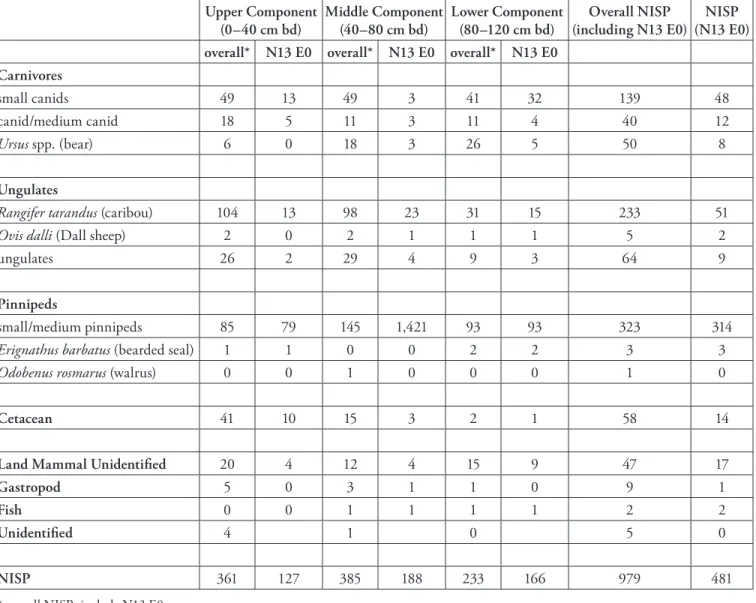
The occupants of Uivvaq appear to have maintained a consistent, broad-spectrum diet and economy much like modern Tikig.ag.miut (Burch 1981:23–34; Foote and Williamson 1966). Fauna were analyzed from multiple units.3 Elements were quantified using number of
identi-fied specimens (NISP) or a bone count. The analysis is in-complete. To date, 979 elements have been identified, 481 coming from N13 E0 (Table 3). Based on the information available, the economically important fauna are small and medium pinnipeds and caribou.
As elsewhere in the Arctic, small and medium seals were the dietary mainstay of the Thule/Iñupiaq econo-my (Murdoch 1892:61–62; Stanford 1976). Seal bones dominate the Uivvaq assemblage in almost all levels in N13 E0. Pinniped representation was: lower component,
57.2%; middle component, 75.5%; upper component, 62.9%. Most remains identified to species were ringed seal (Phoca hispida; n = 117); few were identified as spot-ted or harbor seal (P. largha/vitulina; n = 8). Many seal bones were placed in a more general Phoca spp. (n = 102) or medium phocid/not ribbon seal category (not Phoca
fasciata; n = 9). Both axial and appendicular elements are
well represented, and it appears that carcasses were trans-ported intact to Uivvaq. Flipper elements are particularly numerous (but not yet quantified), as expected if flippers were stored, processed, and consumed. Butchering marks were observed on many seal bones, including round punc-ture holes through the blades of three scapulae. The holes may have been from a projectile, punctured to hang meat for drying, or from erosion through the thinnest part of
the blade. The hole through a spotted seal scapula blade was intentional and there are cut marks around the hole, possibly to remove a harpoon head. Carnivore chewing is present, but not ubiquitous, on small pinniped elements, and erosion of some elements may have been caused by passing through the digestive system of a carnivore or omnivore.
There are isolated remains of the large bearded seal (Erignathus barbatus; n = 3 in Unit N13 E0) and a wal-rus (Odobenus rosmawal-rus) skull fragment in N12 E1 (43 cm bd). More walrus bones were expected because there is a haul-out on the west side of Cape Lisburne (Burch 1981:20). Walrus move northward through leads as the ice is breaking up in the spring and summer and haul out on the ice. Males tend to stay in the Bering Sea and females
Upper Component
(0–40 cm bd) Middle Component (40–80 cm bd) Lower Component (80–120 cm bd) (including N13 E0)Overall NISP (N13 E0)NISP overall* N13 E0 overall* N13 E0 overall* N13 E0
Carnivores
small canids 49 13 49 3 41 32 139 48
canid/medium canid 18 5 11 3 11 4 40 12
Ursus spp. (bear) 6 0 18 3 26 5 50 8
Ungulates
Rangifer tarandus (caribou) 104 13 98 23 31 15 233 51
Ovis dalli (Dall sheep) 2 0 2 1 1 1 5 2
ungulates 26 2 29 4 9 3 64 9
Pinnipeds
small/medium pinnipeds 85 79 145 1,421 93 93 323 314
Erignathus barbatus (bearded seal) 1 1 0 0 2 2 3 3
Odobenus rosmarus (walrus) 0 0 1 0 0 0 1 0
Cetacean 41 10 15 3 2 1 58 14
Land Mammal Unidentified 20 4 12 4 15 9 47 17
Gastropod 5 0 3 1 1 0 9 1
Fish 0 0 1 1 1 1 2 2
Unidentified 4 1 0 5 0
NISP 361 127 385 188 233 166 979 481
* overall NISPs include N13 E0
and immature walruses move into the Chukchi Sea (Sease and Chapman 1988). In the fall, they will haul out on shore during their journey south.
Evidence of whaling is of interest because of its his-toric economic and social importance, but because of the immense size of the prey, large whale hunting typi-cally exhibits low visibility in the zooarchaeological record (McCartney 1995). Historically, large whale carcasses were left on the ice and few elements of the skeleton were brought back to the living areas. Bone appears as artifacts and as byproducts of tool manufacturing and not as rec-ognizable food debris. Two large whale skulls were on the ground surface on either side of Mound 2, and a beluga (Delphinapterus leucas) whale skull was on the surface of one mound. They were also observed in back dirt from a bear excavation. A whale skull embedded within the wall of N14 and N15 E1 was not collected, nor was a scapula 120–125 cm bd in the east wall of N13 E0. Most whale bone identified was from the upper levels of Mound 2. Whale bone was identified sporadically in the lower lev-els. Weathered bones (e.g., crania, mandibles) were on the surface of the middens and surrounding ground, although their age and relation to past occupations is unknown.
Beluga whales winter in the Bering Sea, using polynyas and open leads near Point Hope, Shishmaref, Wales, and the Diomede Islands (Hazard 1988). As the ice melts, the whales migrate northward beginning in April or May, continuing through July (Hazard 1988). A set of eleven beluga vertebrae were found in Unit N16 E1 at 42 cm bd. Traces of meat and blood residue adhered to the ventral surfaces of the bones on the caudal end of the articulated skeleton. The vertebral processes were gnawed by carni-vores, and a large chip and transverse processes were torn away from the right side of the caudal end of the skeleton while the bone was fresh. Morseth (1997: 249–250) stated that the vertebrae from the lumbar to the caudal vertebrae and the cervical vertebrae are either eaten shortly after the animal was killed or were given to the dogs in modern Buckland. The abundance of fly pupal cases and soil mites in the samples of insect remains at the site, in general, support the interpretation that some bones were exposed on the midden surface, particularly during the summer months, as may have occurred with this beluga. Two ver-tebrae on the cranial portion of the articulated skeleton were charcoal stained and burned through the foraminae. The burning probably occurred long after the skeleton was scavenged and after the meat was removed. Three other small cetacean elements were recovered that may be from
beluga. A rib fragment from N13 E0 was cut square on both ends and is a manufacturing byproduct (70–75 cm bd); a forelimb fragment was badly chewed by a large car-nivore, probably by a bear (88 cm bd, N13 E0). A third element from N14 E15 was a vertebra epiphysis. All other cetacean remains were from large whales.
The only burned bones were sea mammal, except for three fox or small canid bones and three other bones that are either stained or burned. The remaining burned bones were pinnipeds (n = 20), cetaceans (n = 11), and uniden-tified mammal bones (n = 3). None were from caribou or other ungulates. Spencer ([1959] 1976:471) and Edna Hunnicutt (Hall 1975:65) both noted that sea mammal bones were burned when a house was moved. Hunnicutt (Hall 1975:65) also stated that sea mammal bones were burned when there was no ice:
At the coast you couldn’t go into anybody else’s tent. A family always puts all the ugruk and seal bones together in one pile so when there was no more ice, when they don’t hunt, they burn those bones, and some bones burn real bright and fast and some people’s pile of ugruk and seal bones doesn’t burn bright, and that family’s pile of bones that don’t burn good the family will “be missing” again [“be missing” means one of the family will die or something will happen to the family], and the family’s bones that are burning brightly always have good luck. After they burned the bones they could visit other tents.
Beluga bones were burned in the nineteenth cen-tury in western Alaska, a pattern that can be inferred and extended to prehistoric Uivvaq and the present-day Buckland area (Morseth 1997:250–251). Burned sea mammal bones were found in association with a number of wood charcoal fragments, burned soil, and fire-cracked rocks in the midden, especially in the lowest levels of ex-cavation Unit N13 E1 (Cultural Levels I, II and III) and in the upper component.
Caribou (Rangifer tarandus) was a significant ter-restrial food source in the nineteenth century (Burch 1981:27–28) and its remains occur throughout the mid-den deposits. Caribou were secondary in importance to seals at Uivvaq even factoring in different processing methods, taphonomy, and body weight. When the NISP of caribou (n = 51) are compared to the NISP of pinnipeds in N13 E0 caribou are 14% of the sum of the two taxa in all components. Many limb bones exhibit tool cut and/ or percussion marks and all limb bones, and most foot bones, were shattered, presumably for marrow extraction.