HAL Id: hal-02048190
https://hal.archives-ouvertes.fr/hal-02048190
Submitted on 26 Apr 2019
HAL is a multi-disciplinary open access
archive for the deposit and dissemination of sci-entific research documents, whether they are pub-lished or not. The documents may come from teaching and research institutions in France or abroad, or from public or private research centers.
L’archive ouverte pluridisciplinaire HAL, est destinée au dépôt et à la diffusion de documents scientifiques de niveau recherche, publiés ou non, émanant des établissements d’enseignement et de recherche français ou étrangers, des laboratoires publics ou privés.
A Paleozoic age for the Tunnunik impact structure
Camille Lepaulard, Jerome Gattacceca, Nicholas Swanson-Hysell, Yoann
Quesnel, François Demory, Gordon Osinski
To cite this version:
Camille Lepaulard, Jerome Gattacceca, Nicholas Swanson-Hysell, Yoann Quesnel, François Demory, et al.. A Paleozoic age for the Tunnunik impact structure. Meteoritics and Planetary Science, Wiley, 2019, 54 (4), pp.740-751. �10.1111/maps.13239�. �hal-02048190�
1
A Paleozoic age for the Tunnunik impact structure
23
Camille Lepaulard1, Jérôme Gattacceca1, Nicholas Swanson-Hysell2, Yoann Quesnel1,
4
François Demory1 , Gordon R. Osinski3,4,
5 6
1Aix Marseille Univ, CNRS, IRD, Coll France, INRA, CEREGE, Aix-en-Provence, France
7
2 Department of Earth and Planetary Science, University of California, Berkeley, California
8
94720-4767, USA 9
3 Dept. of Earth Sciences, Centre for Planetary Science and Exploration, University of Western
10
Ontario, 1151 Richmond St., London, ON, N6A 5B7, Canada 11
4 Dept. Physics & Astronomy, University of Western Ontario, 1151 Richmond St., London, ON,
12
N6A 5B7, Canada 13
14
Corresponding author: Camille Lepaulard ([email protected]) 15
Key Points:
16
• The Tunnunik impact structure is most likely to have formed in the Late Ordovician to early Silurian
17
• The post-impact temperature of the studied target sedimentary rocks was about 350°C
18 19
Abstract
20
We report paleomagnetic directions from the target rocks of the Tunnunik impact 21
structure, as well as from lithic impact breccia dikes that formed during the impact event. The 22
target sedimentary rocks have been remagnetized after impact-related tilting during a reverse 23
polarity interval. Their magnetization is unblocked up to 350°C. The diabase dikes intruding 24
these sediments retained their original magnetization which unblocks above 400°C. The impact 25
breccia records a paleomagnetic direction similar to that of the overprints in the target 26
sedimentary rocks. The comparison of the resulting virtual geomagnetic pole for the Tunnunik 27
impact structure with the apparent polar wander path for Laurentia combined with 28
biostratigraphic constraints from the target sedimentary rocks is most consistent with an impact 29
age in the Late Ordovician or Silurian, around 430 to 450 Ma, soon after the deposition of the 30
youngest impacted sedimentary rocks. Our results from the overprinted sedimentary rocks and 31
diabase dikes imply that the post-impact temperature of the studied rocks was about 350°C. 32
33
1 Introduction
34 35
Hypervelocity impacts are a major process for the evolution of planetary surfaces, 36
including the Earth. Terrestrial impact events have significantly influenced the biosphere in 37
numerous ways including, on one hand, the development of habitats for primitive life forms 38
(Reimold and Koeberl, 2008; Cockell et al., 2005) and, on the other hand, some extinctions such 39
as the Cretaceous-Paleogene mass extinction (Schulte et al., 2010). Depending on the size of the 40
impactor, impact events significantly modify regional geology and may lead to the formation of 41
ore deposits (Ames et al., 1998). However, on Earth, plate tectonics and erosion can obscure or 42
completely erase the geologic record of impact structures. Currently, around 190 impact 43
structures are identified on Earth, including thirty in Canada, but the age of approximately half of 44
these impacts is unknown (Jourdan et al., 2012). Dating of impact structures is crucial for 45
assessing correlations (or the lack thereof) between impact events and biological or geological 46
changes, and to constrain the flux of crater-forming bodies to the Earth through time. 47
While most of the large terrestrial impact structures (> 6 km) on Earth have likely already 48
been documented (Hergarten and Kenkmann, 2015), discovery of additional impact structures is 49
still possible. In 2010, the Tunnunik structure, a ~28 km diameter impact structure was identified 50
in the Canadian Arctic (Dewing et al., 2013). The age of this structure is presently not 51
constrained more precisely than between 0 and ca. 450 Ma. The purpose of this study is to 52
provide a refined estimate for the age of this impact structure. In the absence of suitable material 53
for radiometric dating, we utilize paleomagnetic dating of target rocks that were remagnetized by 54
the impact (Deutsch and Schärer, 1994; Pilkington and Grieve, 1992) and of the lithic breccia 55
that formed during the impact event (Fairchild et al., 2015). 56
2 Geological setting, sampling, methods
57
Geological setting
58
The Tunnunik impact structure is located on Victoria Island in the Canadian High Arctic. 59
The impact structure is deeply eroded and has been identified by the presence of shatter cones, 60
sedimentary rocks steeply dipping quaquaversally (compared to the generally relatively flat 61
regional bedding), and concentric faults (Dewing et al., 2013). The target rock sequence, exposed 62
outside of the impact structure, consists of sub-horizontal sedimentary rocks, mostly dolostones 63
and mudstones, ranging from the Neoproterozoic (Wynniatt formation of the Shaler Supergroup 64
formation) to the Late Ordovician - Early Silurian (?) (Thumb Mountain and Allen Bay 65
formations). Following Newman and Osinski (2016), we group these sedimentary rocks into the 66
Shaler Supergroup (Neoproterozoic), Mount Phayre, Victoria Island, Thumb Mountain and Allen 67
Bay formations in ascending stratigraphic order. 68
Neoproterozoic diabase dikes associated with the ca. 720 Ma Franklin Large Igneous 69
Province which intrude the Neoproterozoic sedimentary rocks are also present within the target 70
rock (Dewing et al., 2013; Heaman et al. 1992). Lithic impact breccias, composed of 71
sedimentary clasts up to centimeter size set in a silt-sized matrix, are encountered in the form of 72
dikes and sills up to a few decimeters thick intruding the sedimentary target rocks, especially the 73
Mount Phayre formation and the Shaler Supergroup formation. 74
Sampling
75
Three main rock types were sampled for paleomagnetic analysis: impact breccia, 76
Neoproterozoic to Upper Ordovician-lower Silurian sedimentary rocks, and Neoproterozoic 77
diabase dikes. For impact breccia sampling, we focused on facies dominated by the fine-grained 78
matrix (clast content below 10 vol%) and with clast size below 1 mm. A total of 29 79
paleomagnetic sites were sampled, mostly located inside the impact structure (Figure 1, Table 80
S1). Sampling was performed by drilling of 2.5 cm-diameter cores using a gas-powered drill, or 81
more rarely through collection of oriented blocks. Samples were oriented using magnetic and sun 82
compasses. 83
Methods
84
The magnetic mineralogy was studied by measurement of susceptibility versus 85
temperature (Figure 2A), stepwise thermal demagnetization of saturation isothermal remanent 86
magnetization (sIRM) that is more sensitive to the presence of pyrrhotite (Figure 2B), and 87
measurements of S-300 ratio that is the IRM obtained after applying a 3 T field and then a back
88
field of − 0.3 T normalized to the IRM acquired in 3 T. The low field magnetic susceptibility 89
(noted χ in m3.kg-1) was measured for all samples using an AGICO apparatus, either with an
90
MFK1 or a KLY-2 kappabridge instrument (with sensitivity of 5x10-13 m3), depending on sample
91
size. The MFK1 kappabridge operates at 200 Am-1 peak field and at a frequency of 976 Hz. The
92
KLY-2 kappabridge operates at 425 Am-1 peak field and at a frequency of 920 Hz.
93
Thermomagnetic curves were obtained with the use of the MFK1 instrument coupled with a CS3 94
furnace. Estimates of Curie temperatures were computed as the inflection points of the 95
susceptibility versus temperature curves. Thermal demagnetization of sIRM (imparted with 3 T 96
pulse with a MMPM9 pulse magnetizer) was conducted using an MMTD furnace. Hysteresis 97
properties of the diabase dikes were measured with a MicroMag 3900 vibrating sample 98
magnetometer. All rock magnetism measurements were performed at CEREGE. 99
All remanence measurements were performed with a SQUID magnetometer (2G 100
Enterprises, model 760R, with noise level of 10-11 Am2) in a magnetically shielded room, with an
101
attached automated 3-axis alternating field degausser system (with a maximum peak field of 170 102
mT). For the majority of samples, the natural remanence was studied (around 100 specimens) by 103
stepwise thermal demagnetization using a MMTD80 furnace. For each studied site, two pilot 104
samples were demagnetized, one using thermal demagnetization up to 600°C, one using 105
alternating field (AF) demagnetization up to 120 mT. The most efficient demagnetization 106
method was then used for the remaining samples. Demagnetization data were analyzed through 107
principal component analysis and summarized with Fisher statistics using PaleoMac software 108
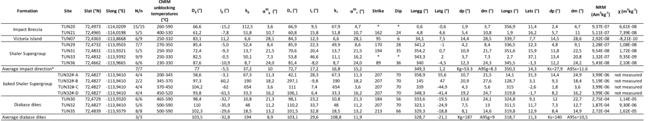
(Cogné, 2003). Paleomagnetic results are summarized in Table 1. 109 110 111 3 Results 112 113
In the impact breccia, thermomagnetic experiments reveal a Curie temperature of 585°C, 114
indicating the presence of magnetite (Figure 2A). Pyrrhotite is also present as indicated by 115
significant unblocking of sIRM around 280-320°C (Figure 2B), although its signal is hidden by 116
the magnetite contribution in the susceptibility curve (Figure 2A). The presence of pyrrhotite is 117
confirmed by the S-300 ratio of -0.84 that indicates the significant contribution of a high
118
coercivity mineral. The impact breccia samples display two magnetization components that are 119
equally evidenced by thermal (Figure 3A) and AF demagnetization (Figure 3B). The low-120
temperature/low-coercivity component corresponds to the present local field. The high-121
temperature (isolated above ~200-350°C and up to the Curie temperature of magnetite at 585°C), 122
high-coercivity (above 15 mT) component is origin-trending and is interpreted as the 123
characteristic remanent magnetization (ChRM). 124
In the diabase dikes, the Curie temperature of ~570°C indicates the presence of 125
magnetite, with a contribution of maghemite identified by an irreversible decay at around 350°C 126
(Figure 2A). The diabase displays two components of magnetization, better evidenced by 127
thermal (Figure 3C) than by AF demagnetization (Figure 3D). The high-temperature component, 128
which is origin-trending, is unblocked between 400 and 590°C. 129
The magnetic mineralogy of rocks from Victoria Island and Shaler Supergroup is a 130
mixture of pyrrhotite and magnetite. Pyrrhotite is evidenced by significant unblocking 131
temperatures of sIRM around 300-320°C (Figure 2B), and the S-300 ratio of -0.79 that indicates
132
the significant contribution of a high coercivity mineral. Pyrrhotite has previously been reported 133
for the Cambrian-Ordovician sedimentary sequence in the region (e.g., Quesnel et al., 2013). The 134
absence of field-dependence of low field magnetic susceptibility suggests a small pyrrhotite 135
grain size (Worm et al., 1993), as classically found in many pyrrhotite-bearing sedimentary rocks 136
(e.g., Rochette et al., 1992). Magnetite is indicated by the significant fraction of the sIRM 137
unblocked above 330°C and up to 580°C (Figure 2B). Among the sedimentary rocks studied for 138
paleomagnetism, 16 out of 21 sites showed unstable remanence during demagnetization and did 139
not provide interpretable results, except for four sites from the Shaler Supergroup and for one 140
site from the Victoria Island formation. These seven sedimentary rocks (dolostones and 141
mudstones) display two components of magnetization, evidenced by thermal demagnetization 142
(Figure 3E-F) where AF demagnetization (not shown) fails to separate both components. The 143
origin-trending high-temperature component is unblocked between 290 and 350 °C (310°C for 144
the only successful Victoria Island site, the remanence being too weak above this 145 demagnetization step). 146 147 4 Discussion 148
It is crucial to determine the age of the remanent magnetizations identified in these rocks 149
relative to the impact. The breccia dikes were formed during the impact event and their magnetic 150
remanence would have been acquired both by the clasts and the fine-grained matrix as they 151
cooled following emplacement and associated frictional heating. It has been shown that impact-152
related tilting occurs quite rapidly, taking place over a timescale shorter than several minutes in 153
mid-sized impact craters (Fairchild et al., 2016). Therefore, the impact breccia is expected to 154
carry a thermoremanent magnetization acquired when the breccia cooled following impact-155
related tilting. Such a timing of impact acquisition has been shown for clastic breccia dikes 156
within the Slate Island impact structure (Fairchild et al., 2016). However, because frictional 157
heating in the breccia dikes is very localized (Fairchild et al., 2016), the target sedimentary rocks 158
and the diabase dikes may or may not have been remagnetized by the impact. 159
A paleomagnetic tilt test was used to estimate the relative timing of magnetization and 160
impact tilting (Tauxe and Watson, 1994). This test was performed at site levels and not within 161
sites because bedding was almost constant at each individual site. As expected, for all studied 162
lithologies, the low-coercivity / low-temperature components fail the tilt test and were therefore 163
acquired following tilting of the beds. The direction corresponds to the present day local 164
magnetic field such that it is interpreted to be a recent viscous overprint (Figure 4C). For the 165
impact breccia, the tilt test is also negative for the high coercivity components and progressive 166
tilt test indicate a maximum grouping of the directions at 0% untilting. The ChRM of the breccia 167
is interpreted as a full thermoremanent magnetization (TRM) acquired as the breccia cooled 168
shortly after breccia emplacement and impact tilting. For the Shaler Supergroup, the tilt test is 169
also negative, as illustrated by the much larger scattering after tilt correction (Figure 4A-B). Only 170
one site from the Victoria Island formation provided paleomagnetic results suitable for 171
interpretation. The tilt-corrected paleomagnetic direction for this site is compatible with that 172
from the Shaler Supergroup and we considered it as a post-tilting impact related magnetization as 173
well. The possible processes to account for post-tilting remagnetization of these sedimentary 174
rocks are thermal magnetization during cooling from impact-related heating, shock 175
magnetization during pressure release immediately after passage of the impact shock wave, or 176
chemical magnetization resulting from post-impact hydrothermal activity (e.g., Zylberman et al., 177
2017). Shock remanent magnetization is excluded as the source of the impact-related 178
magnetization because the release of the shock wave occurs before tilting, so that a shock 179
remanence would pass a tilt test. Both partial or total TRM from impact-related heating and 180
chemical remanent magnetization (CRM) from impact-related hydrothermal activities can result 181
in a remagnetization allowing the structure to be paleomagnetically dated (Pilkington et al., 182
1992). In view of the unblocking temperatures of the natural remanent magnetization (NRM) in
183
the sedimentary rocks (290°C to 350°C), a CRM could be explained by the formation of 184
pyrrhotite during hydrothermal activity (e.g., Osinski et al., 2005). However, because the 185
maximum unblocking temperature of 350°C is slightly higher than the Curie temperature of 186
pyrrhotite (320-325°C), we favor a partial thermoremanent magnetization acquired during post-187
impact cooling from a peak temperature of 350°C. 188
For the three diabase dikes, the tilt test is inconclusive because the beddings of the 189
intruded sediments are similar for the three sites. The ChRM direction is significantly different 190
(before tilt correction) to the average direction computed from the Shaler Supergroup, Victoria 191
Island formation and impact breccia, suggesting that they have not been remagnetized by the 192
impact (Figure 4B). Their virtual geomagnetic poles (VGPs, after tilt correction) are closer to 193
paleomagnetic poles from other igneous rocks of the Franklin Large Igneous Province (Palmer et 194
al., 1983; Denyszyn et al. 2009) than the impact breccia site VGPs. Poorly developed shatter
195
cones have been described in the diabase dikes (Dewing et al., 2013), implying shock pressures 196
above ~2 GPa during the impact event. Such pressure level is well below the pressure-induced 197
magnetite magnetic transition at 12-16 GPa (Ding et al., 2008). Moreover, the coercivity of 198
remanence of samples from the diabase dikes is 39 mT (our measurements, average of 3 199
samples, one per studied dike), and significant shock remagnetization is also unlikely for 200
magnetite with this range of coercivity of remanence (Bezaeva et al., 2010). 201
To test further whether or not the diabase dikes have preserved their primary TRM, we 202
collected 4 oriented cores of the Shaler Supergroup sedimentary rocks that were intruded and 203
baked by the dike, at distances from 3 to 25 cm from the dike wall. In addition to a low 204
temperature viscous component, these samples exhibit four magnetization components 205
unblocked over the following temperature range: between 250 and 345°C, between 345 and 370, 206
between 370 and 450°C, and above 450°C (Table 1, Figure 3G). These components are called A, 207
B, C, D in the following for clarity. Among the three higher temperature components 208
components B and D are identical and close to the reverse polarity ChRM of the diabase dikes 209
(Figure 4C). Component C is antipodal to components B and D. These three components are 210
interpreted as partial TRMs acquired successively during cooling from above 500°C following 211
the diabase dike intrusion. During cooling, the geomagnetic field changed from reverse to 212
normal and back to reverse polarity, leading to the record of antipodal directions D, C, and B 213
successively. Such a record of successive polarity intervals has already been observed in slow 214
cooling sedimentary rocks (e.g., Rochette et al. 1992). Component A blocked up to 345°C has a 215
direction different from the other 3 components related to the dike intrusion but undiscernible 216
(before tilt correction) from the other remagnetized Shaler Supergroup directions. It is 217
interpreted as a partial TRM acquired following the impact. This result indicates that the post-218
impact temperature in these rocks was 345°C, in close agreement with the ChRM peak 219
unblocking temperatures measured in the other Shaler Supergroup sediments within the impact 220
structure. Component A is not recorded in the diabase dikes because these rocks have minimal 221
blocking capacity below 350°C. 222
The impact breccia, Shaler Supergroup formation, and Victoria Island formation all have 223
post-tilting impact-related ChRM. These seven paleomagnetic directions are similar (Figure 4B) 224
and the mean pole calculated from these sites is: 349.3°E, 1.2°N, angular radius of 95% 225
confidence cone A95 = 8.3°, and Fisher precision parameter K = 53.3 (Table 1). The sites may
226
have slightly different magnetization ages due to different blocking temperatures and varied 227
cooling history and as a result may partially average out secular variation. However, the 228
conservative interpretation is that the combined pole represents a snapshot of the paleomagnetic 229
field shortly following impact that does not average out secular variation and should be 230
considered a virtual geomagnetic pole rather than a mean paleomagnetic pole. 231
Comparison of this impact pole with the running mean Apparent Polar Wander Path 232
(APWP) for North America (Torsvik et al., 2012; Besse and Courtillot, 1991) shows that it is 233
closest to the 520, 510 and 500 Ma mean paleomagnetic poles (Figure 5). 234
Following 500 Ma, the angular distance of the Tunnunik VGP becomes progressively 235
greater from the geographic poles implied by the running mean poles of Torsvik et al. (2012) and 236
the paleogeographic model of Torsvik and Cocks (2017) and its modification by Swanson-Hysell 237
and Macdonald (2017) (Figure 6A). From 410 Ma onward to the present, the angular distance 238
between the Tunnunik VGP and the geographic pole exceeds 45º. Deviations between the 239
geographic pole and a virtual geomagnetic pole are expected to arise through secular variation of 240
the geomagnetic field. However, secular variation of the geomagnetic field typically leads to 241
geomagnetic pole positions that are close to the geographic pole. For example, random draws 242
from the paleosecular variation model TK03.GAD (Tauxe and Kent, 2004) for a site at the 243
equator will be within 20º of the geographic pole 90% of the time and within 30º of the 244
geographic pole 95% of the time. The further away an impact VGP is from a pole of a given age, 245
the less likely it is to have formed at that age (see similar discussion in Hervé et al., 2015 and 246
Carporzen and Gilder, 2006). In order to estimate the probability of the Tunnunik VGP having
247
arisen through secular variation throughout the Phanerozoic, the approach developed by 248
Fairchild et al. (2016) was used: the angular distance between the Tunnunik VGP and the
249
paleopoles is compared to that of VGPs randomly sampled from the TK03.GAD secular 250
variation model (Tauxe and Kent, 2004). For this analysis, we simulated 105 VGPs from the
251
TK03.GAD model in 10 million year increments at the paleogeographic position of the crater. 252
Seeking to quantify the probability of an angular deviation between the paleopole and the 253
Tunnunik VGP as large as that determined at each of these times (Figure 6A), we calculated the 254
percentage of simulated VGPs that are at this angular distance or greater from the pole (Figure 255
6B and 6C). While the Tunnunik VGP is closest to North America’s pole path at ca. 500 Ma, this 256
analysis shows that the likelihood of a VGP with the angular distance as large as the deviation of 257
the paleopole of the Tunnunik VGP is greater than 5% at every simulated time during the 258
Ordovician, using the minimum angle given the uncertainty of the VGP. However, given the 259
increasing angular distance of the Tunnunik VGP from Silurian paleopoles (from 420 Ma 260
onward), the likelihood of a VGP at such a distance is less than 5% and continues to be a low 261
probability event all the way to the present. The magnetostratigraphy scale for the 500-420 Ma 262
time interval (e.g., Hounslow et al., 2016), although incomplete, shows multiple reversals and 263
does not allow to better constrain the age of the reverse polarity remagnetization observed at 264
Tunnunik structure. 265
Geologic constraints on the timing of the impact come from the age of early Paleozoic 266
shallow-marine sedimentary rocks within the Tunnunik impact structure. Extensive mapping of 267
the shatter cone distribution at the impact structure reveal the youngest rocks with shatter cones 268
to be those of the Victoria Island Formation (Osinski and Ferrière, 2016). Conodont 269
biostratigraphy has revealed an Early Ordovician age (ca. 487 to 470 Ma) for the Victoria Island 270
Formation (Dewing et al., 2013; Dewing et al., 2015). Faulting associated with impact crater 271
development extends beyond the central region that contains shatter cones and deforms rocks of 272
the Thumb Mountain Formation (Dewing et al., 2013; Newman and Osinkski, 2016). Conodonts 273
and a fossil assemblage of crinoids, corals, gastropods, and cephalopods indicate a Late 274
Ordovician age for the Thumb Mountain Formation (ca. 458 to 445 Ma; Dewing et al., 2013). 275
Overlying the dolostone of the Thumb Mountain is a poorly exposed dolostone unit that Dewing 276
et al. (2013) tentatively assigned to the Allen Bay Formation. Further to the northwest on the 277
Arctic Platform at Devon Island, biostratigraphy on carbonates of the Allen Bay Formation have 278
revealed it to have an age that spans from the Late Ordovician into the Silurian (Thorsteinsson 279
and Mayr, 1987). Mapping of the impact structure has largely left rocks assigned to the Thumb
280
Mountain and Allen Bay Formations undivided (Dewing et al., 2013; Newman and Osinski, 281
2016). Currently the most robust constraint on the maximum age of the impact event is that the 282
development of the impact structure led to faulting of the Thumb Mountain Formation and 283
therefore occurred after ca. 458 Ma. Regional normal faults taken to have formed in association 284
with Early Cretaceous extension cut across the impact structure were interpreted to indicate that 285
the crater formed before ca. 130 Ma (Dewing et al., 2013), but this constraint is rather 286
speculative. 287
The position of the Tunnunik VGP is most consistent with an Ordovician age for the 288
Tunnunik impact. While secular variation of the geomagnetic field naturally results in VGPs that 289
differ from the mean paleopole position, the large angle between the Tunnunik VGP and 290
paleopoles 420 Ma and younger makes a deviation of this magnitude a low probability 291
event (Figure 6). The combined paleomagnetic, stratigraphic and biostratigraphic constraints 292
collectively suggest a Late Ordovician to Silurian age of ca. 430-450 Ma, only shortly after 293
deposition of the youngest impacted sediments. 294
295
5 Conclusions
296
This study focuses on constraining the age of the recently discovered Tunnunik impact 297
structure. Paleomagnetic directions obtained from impact breccia and sedimentary rocks from the 298
target sequence indicate the acquisition of a magnetization following impact-related tilting 299
during a reverse polarity interval. In contrast, the diabase dikes intruding these sediments have 300
retained their original magnetization unblocked above 400ºC. The comparison of the resulting 301
paleomagnetic pole with the apparent polar wander path for North America shows it to be close 302
to Cambrian poles and strongly suggests a Paleozoic age for the crater. The likelihood of the 303
observed impact direction becomes very small (<5% likelihood) if it was acquired after ca. 430 304
Ma suggesting an age of impact that is older than 430 Ma. Combined with the stratigraphic 305
constraints these data indicate an impact age between 450 and 430 Ma, in the Late Ordovician or 306
Silurian Period, soon after deposition of the youngest impacted sedimentary rocks. This old age 307
opens the possibility that ejecta from the Tunnunik crater may have been preserved in the 308
surrounding basin and may be found in the sedimentary rocks of the Arctic platform. 309
The target sedimentary rocks were remagnetized during post-impact cooling. The 310
preservation of pre-impact magnetization unblocked above 400°C in the diabase dikes, and the 311
constraints from the paleomagnetic results obtained on the Shaler Supergroup sediments baked 312
by the intrusions of the diabase dikes indicate collectively that the peak temperature of the 313
thermal excursion associated with the impact was 350°C at the structural level of the studied 314 rocks. 315 316 Acknowledgments 317
This project was partly funded by the French Polar Institute IPEV (Institut Paul Emile Victor). 318
The authors are grateful to the Polar Continental Shelf Project for logistical support. The France-319
Berkeley Fund initiated collaborative research between J.G. and N.L.S.-H. We thank William 320
Zylberman, Cassandra Marion-Beauchamp, and Racel Sopoco for their help in the field during 321
sampling. 322
References
323
Ames, D.E., Watkinson, D.H. and Parrish, R.R. (1998), Dating of a regional hydrothermal 324
system induced by the 1850 Ma Sudbury impact event, Geology, 26, 447–450. 325
Besse, J. and V. Courtillot (1991), Revised and Synthetic apparent polar wander path of the 326
African, Eurasian, North American and Indian plates, and True polar wander since 200 Ma, J. 327
Geophys. Res., 96, 4029–4050. 328
Carpozen, L. and S.A. Gilder (2006), Evidence for coeval Late Triassic terrestrial impacts from 329
the Rochechouart (France) meteorite impact, Geophysical research letters, v.33, L19308, doi: 330
10.1029/2006GL027356. 331
Cockell, C. S., Lee, P., Broady P., Lim, D., Osinski, G., Parnell, J., Koeberl, C., Pesonen, L., and 332
Salminen, J., 2005. Effects of Asteroid and Comet Impacts on Lithophytic Habitats – A 333
Synthesis. Meteoritics and Planetary Science, 40, 12, 1-14. 334
Cogné, J.P (2003), PaleoMac: A MacintoshTM application for treating paleomagnetic data and
335
making plate reconstructions, Geochemistry, Geophysics, Geosystems, 4, 1, 1007, doi: 336
10.1029/2001GC000227. 337
Denyszyn, S. W., Halls, H. C., Davis, D. W., and Evans, D. A. (2009). Paleomagnetism and U– 338
Pb geochronology of Franklin dykes in High Arctic Canada and Greenland: a revised age and 339
paleomagnetic pole constraining block rotations in the Nares Strait region. Canadian Journal 340
of Earth Sciences, 46(9), 689-705.
341
Deutsch A., Schärer U. (1994) Dating terrestrial impact events. Meteoritics, 29, 301-322. 342
Dewing, K., Pratt, B.R., Hadlari, T., Brent, T., Bédard, J. and R.H.Rainbird (2013), Newly 343
identified “Tunnunik” impact structure, Prince Albert Peninsula, northwestern Victoria Island, 344
Arctic Canada, Meteoritics & Planetary Science, 48, 2, 211-223, doi: 10.1111/maps.12052. 345
Dewing, K., Hadlari, T., Rainbird, R.H., and Bédard, J.H., 2015. Phanerozoic geology, 346
northwestern Victoria Island, Northwest Territories; Geological Survey of Canada, Canadian 347
Geoscience Map 171 (preliminary), scale 1:500 000. doi:10.4095/295530 348
Ding Y., Haskel D., Ovchinnikov S. G., Tseng Y.-C., Orlov Y. S., Lang J. C., Mao H. (2008) 349
Novel Pressure induced magnetic transition in magnetite (Fe3O4) Physical Review Letters, 350
100, 045508. 351
Fairchild, L.M., Swanson-Hysell, N.L. and S.M. Tikoo (2016), A matter of minutes: Breccia 352
dike paleomagnetism provides evidences for rapid crater modification, Geological Society of 353
America, 44, 9, 723-726, doi: 10.1130/G37927.1. 354
Gradstein, F.M., Ogg, J.G. and F.J. Hilgen (2012), On the Geological Time Scale, Newsletters 355
on Stratigraphy. 45. 171-188., doi:10.1127/0078-0421/2012/0020. 356
Heaman L. M., LeCheminant A. N., and Rainbird R. H. 1992. Nature and timing of Franklin 357
igneous events, Canada: Implications for a Late Proterozoic mantle plume and the break-up of 358
Laurentia. Earth and Planetary Science Letters 109:117–131. 359
Hergarten, S. and T. Kenkmann (2015), The number of impact craters on Earth: any room for 360
further discoveries ?, Earth and Planetary Science Letters, 425, 187-192. 361
Hervé, G., Gilder, S.A., Marion, C.L., Osinski, G.R., Pohl, A., Petersen, N. and P.J.Sylvester 362
(2015), Paleomagnetic and rock magnetic study of the Mistastin Lake impact structure 363
(Labrador, Canada): implications for geomagnetic perturbation and shock effects, Earth and 364
Planetary Science Letters, 417, 151-163, doi:10.1016/j.epsl.2015.02.011. 365
Hounslow, M.W (2016), Geomagnetic reversal rates following Palaeozoic superchrons have a 366
fast restart mechanism, Nature communication, doi: 10.1038/ncomms12507. 367
Jourdan, F., Reimold, W.U. and A. Deutsch (2012), Dating terrestrial impact structures, 368
Elements, 8, 49-53, doi: 10.2113/gselements.8.1.49. 369
Newman, J.D. and G.R. Osinski (2016), Geological mapping of the Tunnunik impact structure, 370
Victoria Island, Canadian High Arctic, paper presented at the 47th Lunar and Planetary
371
Science Conference, Houston. 372
Osinski, G.R. and L. Ferrière (2016), Shatter cones: (Mis)understood?, Sciences advances, 2, 8, 373
doi: 10.1126/sciadv.1600616. 374
Osinksi, G.R., Lee, P., Parneell J., Spray, J. G., Baron, M. (2005) A case study of impact-375
induced hyrothermal activity: the Haughton impact structure, Devon Island, Canadian High 376
Arctic, Meteoritics & Planetary Science, 40, 1859–1877. 377
Palmer, H.C., Baragar, W.R.A., Fortier, M. and Foster, J.H. (1983), Paleomagnetism of Late 378
Proterozoic rocks, Victoria Island, Northwest Territories, Canada, Canadian Journal of Earth 379
Sciences, 20, 1456-1469, doi: 10.1139/e83-131. 380
Quesnel, Y., Gattacceca, J., Osinski, G.R. and P. Rochette (2013), Origin of the central magnetic 381
anomaly at the Haughton impact structure, Canada, Earth and Planetary Science Letters, 367, 382
116-122. 383
Reimold, W.U. and C. Koeberl (2008), Catastrophes, extinctions and evolution: 50 years of 384
impact cratering studies, Golden Jubilee Memoir of the Geological Society of India, 66, 69-385
110. 386
Schulte, P. and 40 co-authors (2010), The Chicxulub asteroid impact and mass extinction at the 387
Cretaceous-Paleogene boundary. Science, 327, 1214-1218. 388
Sodero, D.E. and J.P.J. Hobson, (1979), Depositional Facies of Lower Paleozoic Allen 389
Bay Carbonate Rocks and Contiguous Shelf and Basin Strata, Cornwallis and 390
Griffith Islands, Northwest Territories, Canada. Am. Assoc. Pet. Geol. Bull., 63, 1059-1091. 391
Swanson-Hysell, N. L. and F. A. Macdonald (2017), Tropical weathering of the Tacnic orogeny 392
as a driver for Ordovician cooling, Geology, doi:10.1130/G38985.1 393
Thorsteinsson, R. and U. Mayr. (1987), The sedimentary rocks of Devon Island, Canadian Arctic 394
Archipelago, Geological Survey of Canada Memoir, 411, 182. 395
Tauxe, L. and D.V. Kent (2004). A simplified statistical model for the geomagnetic field and the 396
detection of shallow bias in paleomagnetic inclinations: Was the ancient magnetic field 397
dipolar? In J. Channell, D. Kent, W. Lowrie, & J. Meert (Eds.), Timescales of the 398
Paleomagnetic Field, 145, 101–116. Washington, D.C.: AGU. 399
Tauxe, L. and G.S. Watson (1994), The fold test – an eigen analysis approach, Earth and 400
Planetary Science Letters, 122, 331-341. 401
Torsvik, T.H. and L.R.M. Cocks (2017), Earth history and palaeogeography: Cambridge, UK, 402
Cambridge University Press, 311, doi: 10 .1017/9781316225523. 403
Torsvik, T.H., Van Der Voo, R., Preeden, U., Mac Niocaill, C., Steinberger, B., Doubrovine, 404
P.V., Van Hinsbergen, D.J.J., Domeier, M., Gaina, C., Tohver, E., Meert, J.G., McCausland, 405
P.J.A. and L.R.M. Cocks (2012), Phanerozoic polar wander, palaeogeography and dynamics, 406
Earth Science Reviews, 114, 325-368, doi: 10.1016/j.earscirev.2012.06.007. 407
Worm, H.-U., Clark, D., Dekkers, M.J. (1993) Magnetic susceptibility of pyrrhotite: grain size, 408
field and frequency dependence. Geophys. J. Int., 114:127-137. 409
Zylberman, W., Quesnel, Y., Rochette, P., Osinski, G.R., Marion, C. and J. Gattacceca, (2017), 410
Hydrothermally-enhanced magnetization at the center of the Haughton impact structure?, 411
Meteoritics and Planetary Science, 1-19, doi:10.1111/maps.12917. 412
413
Figure and Table captions
414
Figure 1. Location of sampled sites. Color codes indicate the sampled formation. Numbered
415
sites are the ones that provided interpretable paleomagnetic results. The red circle is the proposed 416
limit of the impact structure from Newman and Osinski (2016). The purple contour delineates 417
the area where shatter cones have been found. The background image is an Advanced 418
Spaceborne Thermal Emission and Reflection Radiometer (ASTER) Global Digital Elevation 419
Model (GDEM) Version 2 product. The elevation ranges from 0 (white) to 283 m (black). 420
Except for the regional map on the upper left, coordinates are expressed in meters in the 421
Universal Transverse Mercator (UTM) Zone 12 projection with the World Geodetic System 422
(WGS) 84 datum. For the zoomed-in area (upper right), the background image is to a mosaic of 423
orthophotographic images (Digital Globe Quickbird data). 424
Figure 2. Intrinsic magnetic properties of studied rocks. A) Susceptibility versus temperature for
425
a diabase dyke sample (site TUN32, heating and subsequent cooling curves are shown), and an 426
impact breccia sample (site TUN20). B) Thermal demagnetization of sIRM as a function of 427
temperature. The red box indicates the unblocking temperature range of the impact-related 428
magnetization of the target sedimentary rocks. The blue box indicates the unblocking 429
temperature range of the pre-impact magnetization of the diabase dikes. The post-impact 430
temperature excursion is constrained between these two boxes. The Curie temperature of 431
pyrrhotite (325°C) is indicated by the thick vertical line. 432
Figure 3. Orthogonal projection plot of stepwise demagnetization data before tilt-correction.
433
Representative samples of the 3 main formations are presented: A-B) Lithic impact breccia, C-D) 434
diabase dike, E) Shaler Supergroup, F) Victoria Island formation. G) Shaler Supergroup 435
formation sample collected 25 cm away from the diabase dike of site TUN32. For clarity the four 436
components of magnetization recorded in this sample and discussed in the text are highlighted by 437
colored arrows. 438
439
Figure 4. Equal area stereographic projections. Open (closed) symbols are for upper (lower)
440
hemisphere directions. A) Directions of the 24 samples from 4 sites of the Shaler Supergroup 441
sediments before (left) and after (right) tilt correction. The red symbols are the low temperature 442
components (isolated between 280 and 330°C) of the four samples collected within 25 cm of the 443
diabase dike of site TUN32. Blue star is the overall mean direction (samples from site TUN32 444
not included). B) Low temperature directions (grey symbols) and ChRM directions for the seven 445
sites from the impact breccia, Shaler Supergroup and Victoria Island formations listed in Table 1, 446
before tilt correction. Also shown is the average ChRM direction for the 3 diabase dikes 447
(square), and the average present day magnetic field (red star). C) Directions of the four 448
components of magnetization from the Shaler Supergroup sediments collected within 25 cm of 449
the diabase dike at site TUN32. Also shown is the ChRM direction of the diabase dike at this site 450
(in red). 451
452
Figure 5. Comparison of the running mean APWP of Laurentia (Torsvik et al., 2012) with the
453
Tunnunik virtual paleomagnetic pole which is the average of the virtual geomagnetic poles of the 454
impact breccia, Shaler Supergroup and Victoria formations sites. Ages of the running mean 455
APWP poles are labeled from the Cambrian to the Early Devonian. The running mean poles are 456
shown with the calculated 95% confidence circle (A95) associated with the mean of studies that 457
fall within a 20 Myr sliding window. The poles for 520, 460, 450, 390, 380, 360 and 350 Ma are 458
shown with no such confidence circle as there are no studies within the sliding window and the 459
position of the pole for that age is the result of linear interpolation by Torsvik et al. (2012). 460
461 462
Figure 6. A) Angle between Tunnunik impact VGP and paleopoles as a function of time for the
463
Torsvik et al. (2012) APWP, the paleogeographic models of Torsvik and Cocks (2017) and its
464
Ordovician modification by Swanson-Hysell and Macdonald (2017). B) likelihood for a VGP to 465
occur at an angular deviation from the paleopole equal or greater to that observed for the 466
Tunnunik impact VGP for a Fisherian (k=20) distribution of VGPs. C) likelihood for a VGP to 467
occur at an angular deviation from the paleopole equal or greater to that observed for the 468
Tunnunik impact VGP for VGPs drawn from the TK03.GAD secular variation model. 469
470
Table 1. Site-mean paleomagnetic directions from the Tunnunik impact structure. Site TUN32#
471
is for Shaler Supergroup sediments baked by the diabase dike at site TUN32. These samples 472
have four components of magnetization (A, B, C, D, see text). SLat and SLong, site latitude and
473
longitude; N/n, number of samples used in the computation of the mean direction / number of 474
samples stepwise demagnetized; ChRM unblocking temperature, the temperature interval of the 475
high temperature component used for calculation; Dg and Ds, declination before and after tilt
476
correction; Ig and Is, inclination before and after tilt correction; kg and ks (noted Kg and Ks for
477
the average of VGPs) precision parameter before and after tilt correction; α95g and α95s (noted
478
A95g and A95s for the average of VGPs) are semi-angle of aperture of the cone where the true 479
mean direction lies with 95% confidence before and after tilt correction; Strike, strike of the site; 480
Dip, dip of the site; *, Strike and Dip range from 162/16 to 190/38 (site TUN20), from 213/60 to 481
193/70 (site TUN33); For impact breccia and diabase dikes sites, strike and dip are for the 482
intruded rocks; dp is the semi-axis of the confidence ellipse about the VGP along the great circle 483
path from site to VGP; dm is the semi-axis of the confidence ellipse perpendicular to that great-484
circle path. NRM, average natural remanent magnetization; χ, average magnetic susceptibility. 485
*The average impact is computed from sites TUN07, 20, 21, 29, 31, 33, 36 (see text). 486
Magnet ic su scept ibilit y (x10 -9 m 3 ) A 2 6 4 0 0.2 0.4 0.6 0.8 0 100 200 300 400 500 600 impact breccia Shaler Supergroup Victoria Island 1.0 S at urat ion remanence (normalized) Temperature (°C) Figure 2 diabase dike
impact breccia
B diabase dike pyrrhot ite TcSite TU35, sample TU3502b N Up S Down Scale: 10-6 A.m2 NRM 18 mT 45 32 8 W E
a) Lithic impact breccias, AF demagnetization
c) Diabase dykes, AF demagnetization
e) Shaler Supergroup sedimentary rocks
N Up
E S Down
W
Site TU35, sample TU3505a
NRM 290°C 400 500 590 Scale: 10-6 A.m2
Site TU20 sample TU2005A
N Up E S Down W 590 350 NRM 170°C Scale: 10-8 A.m2 E N Up S Down
Site TU20, sample TU2006
14 mT NRM 70 40 28 12 W Scale: 10-8 A.m2 N Up E S Down W
Site TU33, sample TU3305a thermal demagnetization NRM 250°C 310 350 Scale: 10-9 A.m2 Scale: 10-10 A.m2
Site TUN07, sample TUN0707a thermal demagnetization f) Victoria Island sedimentary rocks
N Up E S Down W 120°C 170 NRM 230 250 290 310 FIGURE 3
b) Lithic impact breccias, thermal demagnetization
g) Shaler Supergroup sediments baked by diabase dike
d) Diabase dykes, thermal demagnetization
N Up
E S Down
W
Scale: 10-8 A.m2
Site TU32, sample TU3207a 25 cm away from diabase dyke
NRM 310°C 330 450 500 370 A B C-D 345
b)
a)
N
E
S
W
N
E
S
W
in situ
tilt
corrected
N
E
S
W
in situ
N
E
S
W
c)
baked Shaler Supergroup
sediments at site
TUN32
diabase
dike
at site TUN32
B
D
C
A
N
E
S
W
in situ
tilt corrected
A
D
B
C
diabase
dikes (N=3)
diabase
dike
at site TUN32
Shaler Supergroup
sediments
LT
ChRM
Figure 4
520 Ma
500 Ma
480 Ma
460 Ma
440 Ma
420 Ma
400 Ma
Figure 5
500 400 300 200 100 0 0 20 40 60 80 100 a n g le b etw een T u n n u n ik p o le a n d th e mo d el ed g eo g ra p h ic p o le
Torsvik and Cocks (2017) paleogeographic model
Swanson-Hysell and Macdonald (2017) Ordovician modification Torsvik et al. (2012) running mean APWP
500 400 300 200 100 0 time (Ma) 0 20 40 60 80 100 likel ih o o d o f th is a n g le o r g rea ter fro m p o le (%) 0 time (Ma)
Fisher distribution ( =20) as secular variation stratigraphic
age constraint
5 percent likelihood
Torsvik and Cocks (2017) paleogeographic model
Swanson-Hysell and Macdonald (2017) Ordovician modification Torsvik et al. (2012) running mean APWP
500 400 300 200 100 0 time (Ma) 0 20 40 60 80 100 likel ih o o d o f th is a n g le o r g rea ter fro m p o le (%)
TK03.GAD as secular variation stratigraphic
age constraint
5 percent likelihood
Torsvik and Cocks (2017) paleogeographic model
Swanson-Hysell and Macdonald (2017) Ordovician modification Torsvik et al. (2012) running mean APWP
a)
b)
c)
Table 1 - Paleomagnetic results
Formation Site Slat (°N) Slong (°E) N/n ChRM unblocking temperatures
(°C)
Dg (°) Ig (°) kg α95g (°) Ds (°) Is (°) ks α95s (°) Strike Dip Longg (°) Latg (°) dp (°) dm (°) Longs (°) Lats (°) dp (°) dm (°) NRM (Am2
kg-1 ) χ (m
3kg-1) TUN20 72,4973 -114,0209 15/15 260-590 66,6 -15,2 112,5 3,6 66,9 9,5 67,9 4,7 * * 0,6 -0,6 1,9 3,7 356,9 11,4 2,4 4,7 9,37E-07 6,61E-08 TUN21 72,4965 -114,0198 5/5 400-530 61,2 -7,8 51,8 10,7 60,8 15,8 51,8 10,7 162 24 4,8 4,6 5,4 10,8 1,9 16,2 5,7 11 5,11E-07 7,39E-08 Victoria Island TUN07 72,4363 -113,8668 6/9 250-310 83,1 11,2 6,6 28,1 84,3 12,3 6,6 28,1 95 6 34,1 7,5 14,4 28,5 339,7 7,7 14,5 28,6 2,92E-08 -8,21E-10 TUN29 72,4732 -113,9503 7/7 270-350 85,4 -5,0 52,4 8,4 85,9 22,3 49,9 8,6 170 28 341,2 -1 4,2 8,4 336,5 12,3 4,8 9,1 2,28E-07 1,08E-08 TUN31 72,4831 -113,9321 5/5 250-350 72,4 -9,3 13,7 21,5 70,6 20,4 13,7 21,5 194 35 354,2 0,7 10,9 21,7 351,6 15,9 11,8 22,5 9,54E-08 1,72E-08 TUN33 72,4832 -113,9392 9/9 250-330 82,5 -0,5 50,1 7,3 53,8 46,6 11,1 16,2 * * 343,3 2 3,7 7,3 2,7 37,1 13,4 20,8 1,32E-07 9,35E-09 TUN36 72,4662 -113,9665 6/6 230-330 87,6 -10,9 8,7 24,0 81,4 -8,0 8,7 24,0 89 36 340 -4,5 12,3 24,3 345,5 -1,3 12,2 24,2 5,43E-08 2,10E-08 Average impact direction* 7/7 77 -5,5 37,2 10 72,7 17,2 16,8 15,2 349,3 1,2 Kg=53.3 A95g=8.3 350,3 14,3 Ks=27,9 A95s=11.6
TUN32#-A 72,4827 -113,9410 4/4 200-345 58,6 -3,1 67,3 11,3 42,1 28,3 67,3 11,3 207 70 358,9 55,6 10,7 21,5 14,1 31,3 14,4 24,9 3,99E-06 not measured TUN32#-B 72,4827 -113,9410 2/2 345-370 97,3 60,2 190 18,2 297,1 -9,8 190 18,2 207 70 145 47 20,9 27,6 128,7 3,1 9,3 18,4 5,19E-06 not measured TUN32#-C 72,4827 -113,9410 4/4 370-450 104,2 -62 654 3,6 111 7,4 654 3,6 207 70 339 -44,9 4,3 5,6 315 -2,6 1,8 3,6 3,99E-06 not measured TUN32#-D 72,4827 -113,9410 4/4 450-520 93,8 -61,5 33,3 16,2 106,1 6,4 33,3 16,2 207 70 348,3 -41,4 19,2 24,7 319,8 -1,7 8,2 16,2 3,99E-06 not measured TUN30 72,4729 -113,9320 6/6 465-590 98,4 -32,7 10,8 21,3 98,1 23,2 10,8 21,3 184 56 333,6 -19,5 13,6 24,1 324,8 9,1 12 22,7 2,75E-04 1,14E-05 TUN32 72,4827 -113,9410 5/6 500-590 110 -35,9 48 11,2 110,2 33,7 48 11,2 207 70 323,1 -24,9 7,5 13 311,5 11,7 7,3 12,7 1,87E-04 9,30E-06 TUN35 72,4839 -113,9379 8/8 500-590 102,3 -29,6 18,5 13,2 101,5 32,8 18,5 13,2 213 66 329,3 -18,8 8,1 14,6 319,8 12,9 8,4 14,9 2,72E-04 1,62E-05 Average diabase dikes 3/3 103,5 -32,8 194 8,9 103,1 29,6 108,8 11,9 328,7 -21,1 Kg=187 A95g=9 318,7 11,3 Ks=140 A95s=10,5
Formation Site Slat (°N) Slong (°E) craterI/O distance from center (km) paleomagnetic result TUN20 72,4973 -114,0209 Inside 3,3 yes TUN21 72,4965 -114,0198 Inside 3,3 yes TUN34 72,4821 -113,9376 Inside 0,5 no TUN58 72,4769 -113,8936 Inside 3 no TUN12 72,1422 -112,5139 Outside 61 yes TUN30 72,4729 -113,9320 Inside 0,7 yes TUN32 72,4827 -113,9410 Inside 0,5 yes TUN35 72,4839 -113,9379 Inside 0,7 yes TUN17 72,3326 -114,3965 Outside 22,6 no TUN50 72,4836 -113,9327 Outside 14,9 no TUN51 72,4825 -113,9292 Outside 15,2 no TUN56 72,4759 -113,9063 Outside 12,3 no TUN14 72,1503 -112,5226 Outside 6 no TUN15 72,1513 -112,5230 Outside 61 no TUN16 72,1516 -112,5232 Outside 61 no TUN13 72,1420 -112,5206 Outside 61 no TUN29 72,4732 -113,9503 Inside 0,6 yes TUN31 72,4831 -113,9321 Inside 0,7 yes TUN33 72,4832 -113,9392 Inside 0,5 yes TUN36 72,4662 -113,9665 Inside 1,6 yes TUN21 72,4966 -114,0198 Inside 3,3 no TUN22 72,4971 -114,0200 Inside 3,4 no TUN23 72,4985 -114,0200 Inside 3,6 no TUN28 72,5192 -114,0195 Inside 5,3 no Tan dolostone unit of
Mount Phayre TUN11 72,1643 -112,6376 Outside 56 no TUN03 72,4567 -113,8553 Inside 3,8 no TUN07 72,4363 -113,8668 Inside 5,2 yes TUN10 72,2800 -113,0234 Outside 38 no TUN18 72,2321 -114,0881 Outside 28 no Site TUN12 is from a 150 m wide mafic dike located 60 km away from the impact structure. It paleomagnetic direction (D=58°, I=-4°, a95=8.4, k=84, n=5) is different from the three diabase dykes sampled in the impact structure, but this can be easily accounted for by secular variation of the geomagnetic field since the emplacements of these dykes are not necessarily strictly coeval.
Impact Breccia
Diabase dikes Shaler Supergroup
baked Shaler Supergroup
Impact Breccia
Clastic unit of Mount Phayre
Shaler Supergroup
Stripy unit of Mount Phayre
Victoria Island Table S1 - list of sampled sites.
Mafic dikes