HAL Id: hal-00301635
https://hal.archives-ouvertes.fr/hal-00301635
Submitted on 16 Jan 2006
HAL is a multi-disciplinary open access
archive for the deposit and dissemination of
sci-entific research documents, whether they are
pub-lished or not. The documents may come from
teaching and research institutions in France or
abroad, or from public or private research centers.
L’archive ouverte pluridisciplinaire HAL, est
destinée au dépôt et à la diffusion de documents
scientifiques de niveau recherche, publiés ou non,
émanant des établissements d’enseignement et de
recherche français ou étrangers, des laboratoires
publics ou privés.
Investigation and monitoring in support of the
structural mitigation of large slow moving landslides: an
example from Ca’ Lita (Northern Apennines, Reggio
Emilia, Italy)
A. Corsini, L. Borgatti, G. Caputo, N. de Simone, G. Sartini, G. Truffelli
To cite this version:
A. Corsini, L. Borgatti, G. Caputo, N. de Simone, G. Sartini, et al.. Investigation and monitoring
in support of the structural mitigation of large slow moving landslides: an example from Ca’ Lita
(Northern Apennines, Reggio Emilia, Italy). Natural Hazards and Earth System Science, Copernicus
Publications on behalf of the European Geosciences Union, 2006, 6 (1), pp.55-61. �hal-00301635�
Natural Hazards and Earth System Sciences, 6, 55–61, 2006 SRef-ID: 1684-9981/nhess/2006-6-55
European Geosciences Union
© 2006 Author(s). This work is licensed under a Creative Commons License.
Natural Hazards
and Earth
System Sciences
Investigation and monitoring in support of the structural mitigation
of large slow moving landslides: an example from Ca’ Lita
(Northern Apennines, Reggio Emilia, Italy)
A. Corsini1, L. Borgatti1, G. Caputo2, N. De Simone2, G. Sartini2, and G. Truffelli2
1Dipartimento di Scienze della Terra, Universit`a di Modena e Reggio Emilia, Largo S. Eufemia, 19, 41100 Modena, Italy 2Regione Emilia Romagna, Servizio Tecnico Bacini Enza e sinistra Secchia, Via Emilia S. Stefano, 25, 42100 Reggio Emilia,
Italy
Received: 1 August 2005 – Revised: 23 November 2005 – Accepted: 23 November 2005 – Published: 16 January 2006 Part of Special Issue “Documentation and monitoring of landslides and debris flows for mathematical modelling and design of mitigation measures”
Abstract. The Ca’ Lita landslide is a large and deep-seated
mass movement located in the Secchia River Valley, in the sector of the Northern Apennines falling into Reggio Emilia Province, about 70 km west of Bologna (Northern Italy). It consists of a composite landslide system that affects Creta-ceous to Eocene flysch rock masses and chaotic complexes. Many of the components making up the landslide system have resumed activity between 2002 and 2004, and are now threatening some hamlets and an important road serving the upper watershed area of River Secchia, where many villages and key industrial facilities are located.
This paper presents the analysis and the quantification of displacement rates and depths of the mass movements, based on geological and geomorphological surveys, differ-ential DEM analysis, interpretation of underground strati-graphic and monitoring data collected during the investiga-tion campaign that has been undertaken in order to design cost-effective mitigation structures, and that has been con-ducted with the joint collaboration between public offices and research institutes.
1 Introduction
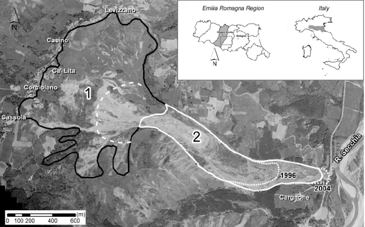
The Ca’ Lita landslide is a complex and composite roto-traslational rock slide-earth flow (WP/WLI 1993; Cruden and Varnes, 1996) affecting Cretaceous to Eocene flysch rock masses and chaotic complexes (Regione Emilia-Romagna, 1982), that can be classified as overconsolidated weak rocks (sensu Bieniawski, 1989), with a marked lithological and structural complexity (A.G.I., 1985). It is located in the Sec-chia River Valley, in the sector of the Northern Apennines falling into Reggio Emilia Province, Northern Italy (Fig. 1). Correspondence to: A. Corsini
(corsini.alessandro@unimore.it)
The landslide resumed activity in 2002 and since then has al-ternated surge phases (like in winter 2003 and, in particular, early spring 2004) and periods of almost suspended move-ments (generally summer). The style of movement (Cruden and Varnes, 1996) of the landslide in the period spanning from 2002 to 2004 was retrogressive in the upper part, ad-vancing in the mid-lower part, and partially widening on flanks. Mass movements reached peak velocities of about 10 m per day at the toe, while in the source area, rotational rock slides and traslational earth slides evolved at velocities of cm-dm per day. Locally, quite superficial mudflows, or collapses of the rockslide front, moved as fast as metres per hour.
At present, August 2005, the landslide extends from an el-evation of 650 m at the crown to 230 m at the tip. Its total track length is approximately 3 km and its maximum width is about 1.4 km in the rear scarp area, with a maximum depth of about 50 m in the upper part (Fig. 1). During 2002–2004 period the toe of the landslide has advanced for more than 400 m over a slope angle of about 10◦, causing the filling of the local valley with a 30 m thick deposit. It has been estimated, on the basis of DEMs comparison, that the reacti-vation events between 2002 and 2004 have mobilised some-thing like twenty millions cubic meters of mixed clays and boulders (Borgatti et al., 2006).
The reactivation of the Ca’ Lita landslide caused partic-ular concern to civil protection authorities for the possible interruption of road connection to the upper Secchia River basin caused by the advancement of the landslide toe and for the possible involvement of some hamlets located at the crown due to retrogressive sliding. During the most criti-cal weeks, excavators worked for controlling the advance-ment of the front of the landslides on a 24 h shift basis, while technicians kept under constant visual control the retrogres-sive phenomena at the crown. After-emergency interventions
56 A. Corsini et al.: Large slow moving landslides in the Northern Apennines
Fig. 1. Geographical location of the study site and sketch of the two distinct phenomena that make up the Ca’ Lita landslide. 1: Rotational
and – translational rock slides – earth slides. 2: Earth slides-earth flows. Broken white line: main scarp of the earth slide-earth flow. Dotted white lines: tip of the landslide deposits in 1996 and during the emergency phase of 2004.
have mainly consisted in the re-arrangement of material on the landslide body and reshaping of the topographic surface, carried out in order to seal fissures and cracks and to avoid the formation of water impoundments in reverse-slope situa-tions. Also surface drainage networks were restored, mainly through the creation of diversion ditches. A few months af-ter the emergency, an investigation and monitoring campaign aimed at collecting relevant data for the design of structural mitigation measures was started.
The complexity and large dimension of landslide make its structural mitigation a very serious problem. However, the “do nothing” option, that is often preferable for such large phenomena, is not a viable one in this case. This is because the relocation of the private properties endangered by the phenomenon would have to consider, also, indirect social as-pects and costs, and that the deviation to an alternative route of the principal road at the bottom of the slope would only be possible if a massive economic effort was put into bridging it over the contiguous Secchia riverbed. Therefore, a structural mitigation action had to be undertaken, being conscious of technical difficulties and uncertainties regarding its success.
The general approach to the structural mitigation of the Ca’ Lita landslide arose from previous experiences on simi-lar phenomena in the area, and is based on few simple prin-ciples: restore an efficient surface drainage pattern; create a deep-drainage system by means of pits and sub-horizontal
drains, protect the deep drainage systems for the time needed for them to actually have a stabilisation effect on the slope by means of deep-founded anchored pile walls. This type of approach was applied in key critical sectors of the slide, that were identified by direct observation of the land-slide evolution mechanisms and detailed field survey sup-ported also by high definition DEMs produced with an air-borne LiDAR survey. As previously mentioned, in these sec-tors of the landslide, preparatory geotechnical investigation and monitoring has been carried out in order to evaluate the feasibility of certain mitigation structures and to support their technical design.
2 Preparatory geotechnical investigation and monitor-ing in critical areas
The landslide, classified as a complex and composite phe-nomenon (WP/WLI 1993; Cruden and Varnes, 1996), can be subdivided into two main phenomena, one affecting the up-per slope and the other the medium to lower slope (Fig. 1).
The uppermost phenomenon takes place in relation to a general processes of rock block sliding affecting flysch rock masses. In this area, rotational and traslational rock slides take place and, in many cases, evolve into earth slides or mud flows (Hungr et al., 2001). In particular, in the southern sector a more than 100 m thick flysch slab is dipping upslope
A. Corsini et al.: Large slow moving landslides in the Northern Apennines 57
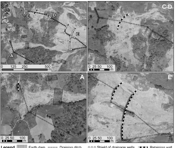
Fig. 2. Key areas selected for investigation and monitoring (A–E) and location of instrumented boreholes and refraction seismic lines.
Table 1. Description of the Ca’ Lita landslide system critical areas. Legend: Geological Units: MOH3 – Monghidoro Fm., Flysch; VRO –
Val Rossenna Clays Fm., clayey chaotic complex; MVR2a – Val Rossenna M´elanges Fm., clayey chaotic complex. Attitude: up = upslope; do = downslope. Way-up: ur = upright; ov = overturned. * = measured;◦= estimated. In sector B no displacements have been detected up to date.
Slope movements Investigation and monitoring areas
characteristics A – Cassola B – Corciolano C – Ca’ Lita D – Piana E – Colata Type of movement Roto-transl.
earth slides Roto-transl. rock slides Roto-trans. earth slides Roto-transl. rock slides – earth slides
Translational earth slides – flows Affected bedrock MOH3 (up/ov),
MVR2a (up/ov)
MOH3 (up/ov) MOH3 (do/ur) + (up/ov)
MOH3 (up/ov) MVR2a (up/ov), MOH3 (do/ur), VRO (do/ur)
Landslide material Clay, silt, blocks Disarranged rock masses
Clay, silt, blocks Clay, silt, blocks + dismembered rock masses
Clay, silt + blocks in the upper meters Total thickness 10–25 (m) – 20 (m) 45 (m) 15 (m) Depth of sliding 5 and 20* (m) – 15* (m) 43* and 20* (m) 9* (m) Min. displacement rate cm/month* – cm/month* cm/month* dm to m/month* Max. displacement rate dm/day◦ – dm/day◦ dm/day◦ m/day◦ Groundwater depth 2–6* (m) 17–18* (m) 8–2* (m) 10–25* (m) 1–8* (m)
58 A. Corsini et al.: Large slow moving landslides in the Northern Apennines
Fig. 3. Sketch of the structural mitigation measures built in the key areas A, C, D and E since spring 2005.
and overlays the basal clayey chaotic complexes. This causes a stiffness contrast that, in conjunction with the presence of pervasive structural discontinuities, causes the sliding of huge rock blocks that, at the surface, is evidenced by a series of trenches located in the crest leading to Corciolano.
The lowermost phenomenon is essentially a rotational earth slide – earth flow affecting the degradated part of clayey complexes and debris material coming from the uppermost phenomenon. Large part of its primary detachment scarp is buried by the debris material convoyed into the source area of the lower landslide by the retrogression of the marginal portion of the flysch slab undergoing deep sliding, and by other very frequent mud flows and earth flows triggered in the uppermost landslide area.
The preparatory underground investigation and monitor-ing campaign was principally aimed to: define landslide thickness and bedrock depth (by seismic surveys and bore-holes); define geotechnical properties of the landslide mass
(by core sampling, laboratory analysis and permeability tests on boreholes); estimate movements rate and depth (in-clinometers and TDR cables, wire extensometers); define groundwater level fluctuation range and timing with respect to rainfall and acceleration of movements (piezometers with electric transponders).
Altogether, the investigation and monitoring campaign consisted of (Fig. 2): a new aerial photo coverage at 1:14 000; a detailed landslide map at 1:5000 scale; 88 mm cores of landslide masses and bedrock from 16 boreholes, 40 to 90 m deep; a set of monitoring data obtained from 9 inclinome-ter casings, 2 Time Domain Reflectomeinclinome-ter cables (TDR) of 41.3 mm diameter, 2 extensometers and 6 piezometers, some of which equipped with electric pressure transducers and data-loggers for continuous acquisition; refraction seismic on 16 cross and longitudinal sections, elaborated with tomog-raphy techniques.
A. Corsini et al.: Large slow moving landslides in the Northern Apennines 59
Table 2. Specifications of mitigation intervention in the key sectors.
Draining wells specifications Structural intervention areas
A – Shield Cassola C – Shield Ca’ Lita D – Shield Piana E – Shield Colata
no. of wells in the shield 4 15 12 20
Depth (m) 9.0÷10.0 13.0÷20.0 30.0 8.0÷10.5
Diameter (m) 1.2 1.2÷1.5 1.2÷1.5 1.2
Average distance between wells (m) 7.0 7.0 7.0 7.0
Depth of the low-level collector (m) −7.5÷−8.5 −11.5÷−18.50 −28.50 −6.5÷−9.0
Diameter of the low-level collector (mm) 86 86 86 86
Internal diameter of the discharge collector (mm) 120–136 120–136 120–136 120–136
Pumping Gravity flow Gravity flow Gravity flow Gravity flow
Retaining walls specifications Structural intervention areas
A – Wall Cassola C – Wall Ca’ Lita D – Wall Piana E – Wall Colata
Length (m) 48.50 97.5 118.9 292.5
Height of the kerb (m) 1.0 1.0 1.0 1.0
Height of the wall (m) 2.0 2.0 2.0 2.0
Thickness of the kerb (m) 1.5 1.5 2.6 2.6
Thickness of the wall (m) 0.40 40 50 50
Depth of piles (m) 7.3–11.3 11.3 9.3–11.3 11.3
Diameter of piles (mm) 1000 1000 1000 1000
No. of piles 30 40 72 232
Anchors five 75 t strands five 75 t strands five 75 t strands five 75 t strands
Length of anchors (m) 25.0 25.0 25.0 25.0
No. of anchors 10 22 44 112
Diameter of anchors core (mm) 150 150 150 150
Pre-tensioning/tensioning (t) 40–50 40–50 40–50 40–50
Inclinometers – – 1 3
Pressure gauge 1 2 2 3–4
This extensive set of information was needed in order to answer some key questions such as: is bedrock shallow enough to have piles firmly drilled into it?, can the water ta-ble be intercepted and significantly lowered by deep drainage pits?, is the sliding surface at a depth that intercepts the pits, hence risking to cut them?, is the movement rate at present days low enough to allow pits and piles for the sustaining structures to be drilled and kept stable until anchors bulbs can be tensed and drainages make effect?, and so on.
This interpretation of slope failure mechanisms, together with the evidence collected during the recent reactivation events and other specific analyses (see Borgatti et al., 2006), was the basis on which the main critical zones of the land-slide were selected for investigation and monitoring. These are indicated as A to E in Fig. 2.
The relevant results obtained in the different key zones are summarised in Table 1.
On the basis of the surveys and monitoring data so far col-lected, it is believed that the mechanisms and times of reacti-vation of the landslides are governed by the hydrogeological setting of the study area and, in particular, by a circuit of groundwater directed from the uppermost slab into the low-ermost clays, in which the sliding surfaces develop. Con-cerning groundwater circulation, the area display numerous small springs with seasonal discharge that lie in
correspon-dence with permeability boundaries between the flysch slab and the clayey substratum, which by now is covered by a thick debris deposit. The depletion zone of the upper land-slide acts as a basin, that keeps the debris in a saturated state, thus promoting movements especially in occasion of intense and/or prolonged rainfall or rapid snowmelt, that are the con-ditions occurred before the main reactivation events. Start-ing from these premises, the mitigation strategy has been de-signed with the principal aim to lower the groundwater level at the slope scale.
3 Structural mitigation measures
Starting from the spring 2005, permanent structural consol-idation works (Holtz and Schuster, 1996) have been carried out in four of the five key areas described beforehand. Struc-tural mitigation is based on various types of draining tures, such as groins and draining wells that have also a struc-tural function. The drainage systems are coupled with re-taining walls founded on piles that are meant to ensure their stability for the time needed to become significantly efficient (Fig. 3, Table 2). In a few other areas earth dams have been built to act as barriers on specific flow fronts.
At all the four intervention locations, subsurface drainage is guaranteed by sets of large diameter vertical wells drilled
60 A. Corsini et al.: Large slow moving landslides in the Northern Apennines
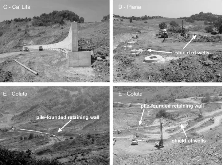
Fig. 4. Structural mitigation measures built in the key areas C, D and E since spring 2005.
closely one another, in order to create a sort of drainage front. Each well is connected to its neighbour at the bot-tom by horizontal drains. These systems normally drain by means of gravity flow; however, during construction phases pumps have been used temporarily in order to remove water from low-level collector galleries for example in case of in-tense rainfalls. Generally, in the apenninic setting the major drawback of draining works is due to the low permeability of landslide materials. In this specific case, some pumping tests carried out during December 2004 in 16 m deep exploratory pits, have allowed a yield of the highly disarranged sliding flysch masses in the order of 6 l/s to be estimated, that in-dicates a high trasmissivity of the rock masses. The good hydraulic response of the landslide deposits ensures the effi-ciency of the designed measures. In any case, the expected maximum efficiency is generally achieved only months after the implementation of the system, whereas in the meanwhile the extent of displacements could seriously compromise the draining system itself. For this reason, in all the intervention locations, the shields of drainage wells have been designed coupled with structural retention systems located downslope, that are funded on piles and anchored to the bedrock. In par-ticular, these reinforced concrete wall are founded on
bored-in place not contiguous pile shields. The rebored-inforcement is guaranteed by tied-back anchors that are installed and ten-sioned against the face of the wall. The wall acts partially as a retention structure, but in particular is a large reaction plate for rock anchors, that distribute the anchor loads into the rock mass (Fig. 4).
It is clear that this kind of semi-rigid structures might suf-fer damages under the active pressure of the moving mass. For this reason, in the area E, it has been kept close to the top of the lobe, taking also advantage of the shallow location of bedrock, that in this sector is not deeper than 9–10 m and is outcropping in ridges that have been partially buried by the upper landslide debris. It is clear that the effectiveness of this structures can be minimized in case of new massive input of materials from the upper part of the slope, related to large collapses of the rock slide front or new mudflows, that might cause them to be buried under meters of debris. In conclusion, it must be stressed that the main function of these structures is to guarantee the protection of the draining wells as much as possible and not to operate as an actual retention system, that considering the depth of the sliding surfaces and the height of the active landslide scarps, would be definitely underestimated.
A. Corsini et al.: Large slow moving landslides in the Northern Apennines 61 One of the key issues is to carry away from the slope the
water drained by the wells and collected by the outlet drains, in order to promote a rapid runoff and improve slope stabil-ity. For this purpose, an adequate pattern of diversion ditches and collectors have been designed to convey the water to the streams that border the landslide body.
4 Conclusions and perspectives
On the basis of the surveys and of the investigation and moni-toring data so far collected, it is believed that the mechanisms and the evolution of the landslide are driven by the geologi-cal and structural features, together with the hydrogeologigeologi-cal setting of the study area and, in particular, by a circuit of groundwater directed from the uppermost slab into the low-ermost clays, in which the deeper sliding surfaces develop. Concerning groundwater circulation, the area display numer-ous small springs lying in correspondence with permeability boundaries between the flysch slab and the clayey substra-tum, which by now is covered by thick debris deposits. The depletion zone of the landslide unit acts as a basin that keeps the debris in a saturated state, promoting significant move-ments directly connected with severe meteo-climatic events. The investigation and monitoring data presented in this pa-per have been the basis on which to plan and engineer mit-igation measures and strategies and then to check for their efficiency. In the first emergency phase, the consolidation works have consisted in the re-arrangement of displaced ma-terials, in order to avoid the formation of water impound-ments and to restore drainage networks. Permanent consoli-dation works consist of draining trenches, check dams, drain-ing wells and sub-horizontal drains. Structural works and containment structures have also been built over pile founda-tions reaching the bedrock at 10 to 15 m of depth, in order to protect drainage systems.
Owing to the dimensions and lithological characteristics of the landslide, it is very difficult to achieve definitive consoli-dation at reasonable costs, if compared to the intrinsic value of the buildings and structures subject to risk. Indeed, the re-lationship between landslides and urban development in the Northern Apennines is a problem that cannot definitely be unravelled. The development of many inhabited centres has often taken place in conditions of precarious slope stability, since in many cases definitely safe areas or possible alterna-tives were not available. In other cases, the presence of large, dormant landslides with wide and flat accumulation zones has allowed the development of many villages since ancient times (Bertolini and Pellegrini, 2001). For this reason, an investment of a total amount of 3 000 000 EUR been con-sidered affordable and “politically” sustainable by the public boards.
The Ca’ Lita landslide reactivation case history is a notice-able example of the possible evolution of landslides involv-ing weak rock masses in an apenninic settinvolv-ing. Case stud-ies such as the Ca’ Lita landslide should in fact be anal-ysed in detail, so to provide a complete case history, also
thanks to the relatively fast development undergone by the phenomenon, essential for the understanding of landsliding mechanisms and for the planning of a correct and durable mitigation and consolidation action.
Acknowledgements. Geognostic and monitoring data have been
collected by Servizio Tecnico dei Bacini Enza e sinistra Secchia of Regione Emilia-Romagna, in the frame of the Intervention Plan supported by Ordinanza del Presidente del Consiglio dei Ministri n. 3357/2004 and Decreto del Presidente del Consiglio dei Ministri 08/07/2004 concerning “Movimenti franosi verificatesi nei Comuni di Baiso e Canossa nel febbraio 2004”. Distinct contribution of authors: L. Borgatti and A. Corsini have conceived and written the paper, and have elaborated most of the figures and tables. G. Caputo, N. De Simone, G. Sartini and G. Truffelli have planned and managed geognostic investigation, monitoring campaigns and the design and building of mitigation measures.
Edited by: G. Lollino Reviewed by: one referee
References
A.G.I.: Associazione Geotecnica Italiana: Geological outline of Italy: bearing of the geological features on the geotechnical characterization on the example of some typical formations, in: Geotechnical Engineering in Italy, edited by: A.G.I., Tip. L. Chiovini, Roma, 159–184, 1985.
Bertolini, G. and Pellegrini, M.: The landslides of Emilia Apen-nines (northern Italy) with reference to those which resumed ac-tivity in the 1994–1999 period and required Civil Protection in-terventions, in: Le frane della Regione Emilia-Romagna, oggetto di interventi di Protezione Civile nel periodo 1994–1999, edited by: Bertolini, G., Pellegrini, M., and Tosatti G., Quaderni di Ge-ologia Applicata, 8, 27–74, 2001.
Bieniawski, Z. T.: Engineering rock mass classification, Wiley In-terscience Publ., New York, 1989.
Borgatti, L., Corsini, A., Barbieri, M., Sartini, G., Truffelli, G., Caputo, G., and Puglisi, C.: Active large-scale slow moving landslides in weak rock masses: a remarkable example from the Northern Apennines (Italy), Landslides, in press, 2006. Cruden, D. M. and Varnes, D. J.: Landslides Types and Processes,
in: Landslides: Investigation and Mitigation, edited by: Turner A. K. and Schuster R. L., Transportation Research Board, Special Report 247, National Academy Press, Washington D.C., 36–75, 1996.
Holtz, R. D. and Schuster, R. L.: Stabilization of soil slope, in: Landslides: Investigation and Mitigation, edited by: Turner A. K. and Schuster R. L., Transportation Research Board, Special Report 247, National Academy Press, Washington D.C., 439– 473, 1996.
Hungr, O., Evans, S. G., Bovis, M. J., and Hutchinson, J. N.: A review of the classification of landslides of the flow type, Envi-ronmental and Engineering Geoscience, 7, 221–238, 2001. Regione Emilia-Romagna: Carta geologica dell’Appennino
emiliano-romagnolo 1: 10.000. Resp. Pignone R., Ed. SELCA, Firenze, 1982.
WP/WLI – Working Party on the World Landslide Inventory & Canadian Geotechnical Society: Multilingual Landslide Glos-sary, BiTech Publishers, Richmond, B.C., 1993.