HAL Id: halshs-00762365
https://halshs.archives-ouvertes.fr/halshs-00762365
Submitted on 20 Dec 2018HAL is a multi-disciplinary open access
archive for the deposit and dissemination of sci-entific research documents, whether they are pub-lished or not. The documents may come from teaching and research institutions in France or abroad, or from public or private research centers.
L’archive ouverte pluridisciplinaire HAL, est destinée au dépôt et à la diffusion de documents scientifiques de niveau recherche, publiés ou non, émanant des établissements d’enseignement et de recherche français ou étrangers, des laboratoires publics ou privés.
Alain Nadaï, Olivier Labussiere
To cite this version:
Alain Nadaï, Olivier Labussiere. Wind Power and the Emergence of the Beauce Landscape, Eure-et-Loir, France. Landscape Research, Taylor & Francis (Routledge), 2015, 40 (1), pp.76-98. �10.1080/01426397.2013.784732�. �halshs-00762365�
Wind Power and the Emergence of the Beauce Landscape (Eure-et-Loir, France) 4 5 6 7 8 9 Alain Nadaï1 10
CIRED - Centre International de Recherche sur l'Environnement et le Développement
11
Jardin Tropical
12
45 bis avenue de la Belle Gabrielle
13 94736 NOGENT-SUR-MARNE Cedex 14 E-mail : nadai@centre-cired.fr 15 16 Olivier Labussière 17
CIRED - Centre International de Recherche sur l'Environnement et le Développement
18
Jardin Tropical
19
45 bis avenue de la Belle Gabrielle
20 94736 NOGENT-SUR-MARNE Cedex 21 E-mail : olivier.labussiere@centre-cired.fr 22 23 24 1Corresponding author.
4 5
Wind Power and the Emergence of the Beauce Landscape (Eure-et-Loir, France) 6 7 8 9 10 11 Abstract 12
In 2003 wind power arrived massively in the Beauce (at the outskirts of the Parisian basin). This article
13
follows the evolving practice of landscape planning over the course of wind power development in this
14
region of France. Our analysis suggests that landscape is regulated through practices, discourses and
15
aesthetic codes, which define what is important about landscape and attempt to protect it. It shows that
16
wind power not only affects existing landscapes, but also challenges the working of these underlying
17
practices and discourses, triggering the emergence of new codes. By calling for a renewal in the way in
18
which we regulate and experience our landscapes, wind power enables us better to understand the way in
19
which the energy transition might raise issues about landscape protection.
20 21 22 23 Keywords 24
Planning - wind power – actor network – aesthetic codes
25 26 27 28
4 5 6 7 Introduction ... 1 8
1 Material and methods ... 2 9
2 Before wind power: Chartres Cathedral, centre of a state-landscape ... 3 10
3 The rise of wind power: a State off-centre ... 5
11
31. One centre (Cathedral), many epicentres (wind turbines) ... 5 12
32. Capturing epicentres (photomontage), penetrating the landscape ... 6 13
4 Re-centering the state-landscape: calling upon the Beauce ... 7 14
41. Including the Beauce landscape in a planning approach ... 8 15
Re-photographing the Beauce ... 8 16
New principles and new tools for planning the Beauce landscape ... 9 17
42. Excluding the public from the Beauce landscape ... 11 18
Participation in devising wind power development zones ... 11
19
Participation in authorisation processes ... 11 20 5 Conclusion ... 12 21 References ... 14 22 Figures ... 17 23 24 Supprimé: 10 25 Supprimé: 10 26 Supprimé: 13 27 Supprimé: 16 28
Introduction 1
‘We are in the newly finished building of the Ministry of Culture. Civil servants in charge of heritage and 2
landscape protection have come from all French regions (departments) to attend a national meeting on 3
wind power. I have been invited to give a talk on wind power and sustainable development. The room is 4
full. The atmosphere is highly charged after a reportedly tense morning session. The central administration 5
is in the hot seat. It is time for the civil servant from Eure-et-Loir (at the outskirts of the Parisian Basin) to 6
give an account of her experience with local wind power. While commenting on what she conceives ‘also’ 7
to be a clear case of failed policy (implicitly referring to the discussions of the morning session), her first 8
slide ( a map) is on the screen. A bright red, radiating figure is at the centre. It pictures what should have 9
been protected from wind power but was not: Chartres Cathedral. The Cathedral literally irradiates the 10
surrounding landscape, la Beauce, here made up to resemble an urchin-like, fully geometric figure: in 11
some ways a translation of an open landscape, a landscape under the influence of the Cathedral. The figure 12
is not only instructive in its size and presence on the screen (the room has suddenly become reddish); it is 13
also striking because of the approach to landscape to which it bears witness. The Cathedral assumes a 14
solar mode of existence, endowing its surroundings with its presence at the centre. It points as much to a 15
landscape that has been denied under this “failed policy” approach as to a landscape that will have to be 16
taken into account once wind power has genuinely been made part of landscape policy.’ (field notes, Paris, 17
July 2007).
18
This paper has been inspired by that reddish instant. Beginning in 2002, wind power arrived massively [I
19
don’t see the problem with this word.] in the Beauce (department of Eure-et-Loir, at the outskirts of the
20
Parisian Basin). By 2007, the department of Eure-et-Loir already had one of the largest wind power
21
capacities in France: 444 MW were approved (incl. 231 MW in use in 2007), which translates to about 222
22
2MW-turbines2. This made the region into a central issue for the administration. Yet, instead of triggering a
23
geographical extension of previous landscape protection in the Beauce, wind power challenged existing
24
routines of (mainly visual) landscape protection. The scale and number of turbines hampered the
25
administration from continuing to rely on the usual planning categories, such as foreground and distant
26
landscape, patrimonial and non-patrimonial landscapes. In this process, La Beauce, an open field landscape
27
with no heritage value whatsoever for the French state [I note that here ‘state’ is not capitalized. Decide
28
where and when it should (for special emphasis) or should not be capitalized and revise accordingly.],
29
emerged as a landscape deemed worthy of protection. Thus, beyond the specific case study, this paper is
30
about a process through which new ways of representing and valuing landscape might emerge through
31
planning. As such, it bears upon upcoming issues in landscape studies: ‘landscapes of energies’ (Nadai &
32
van der Horst, 2010b) is a term that has been used to point to the need for observing and analyzing the
33
processes by which our landscapes will evolve in the course of the energy transition.
34
Landscape issues in relation to wind power have been important in France and the UK since the take-off of
35
this kind of energy in these countries in the early 2000s3. Today they also occur in other European
36
countries, such as Denmark and Germany, currently famous for their successful ‘civic’ model based on
37
local ownership of wind farms (Bolinger, 2005; Meyer, 2007; Nielsen, 2002; Möller, 2010). A striking
38
feature in social science literature on wind power development is the uneven consideration of landscape
39
issues. Some analysts have attempted to relate landscape issues to visual impact through quantification
40
(Bishop 2002; Möller, 2010). Others have discussed landscape issues in relation to the extent of public
41
consultation and deliberation in planning (Ellis et al., 2010; Fisher & Brown, 2009, Wolsink, 2010; Toke et
42
al., 2008; Zografos & Martínez-Alier, 2009; Gee, 2010), eventually pointing to the ways in which
43
landscape was represented in planning processes (Cowell, 2010; Nadaï, 2012; Nadaï & Labussière 2009 &
44
2010; Labussière & Nadaï, 2011; Jolivet & Heiskanen 2010).
45
We expand these analyses by considering the ways in which wind power development can induce changes
46
in the manner landscape is protected and regulated. Planning processes provide an arena for following and
47
understanding such changes. Hence we do not attempt, for instance, to assess the impact of wind power
48
2 Between December 2002 and October 2006, the size of the projects ranged from 1 to 10 turbines, with an average project size of 4 turbines
(145 turbines, 35 projects) (DDE, 2006).
development on the perception of landscape by local inhabitants or to quantify the visual impact of wind
1
power on landscape. Instead we follow the evolving practice of landscape planning over the course of wind
2
power development in a French region so as to understand the extent to which this development triggers
3
changes in the way planners approach and implement landscape protection.
4
The tensions between wind power development and landscape protection have a cultural dimension (Nadaï
5
et al., 2010). In France, landscape protection has traditionally been articulated in terms of visual relations
6
and scenic landscapes. A genuine geometry of visual relations ended up underpinning the French state
7
approach to landscape protection. Co-visibilities between new developments and landmarks, considered to
8
be of heritage value by the French state, are a key category for governing [Some might think this verb odd
9
here and prefer one like ‘regulating’. But it seems to me that you mean to evoke the relevant connotations
10
of ‘govern’.] the landscape. Thus French landscape protection is both centralised (under French state
11
responsibility) and centred in visual relations and heritage elements. Since industrial wind turbines are
12
decentralised infrastructures that are visually perceptible from a distance, especially in open landscapes, it
13
will come as no surprise that the development of wind power puzzled French landscape planners.
14
As suggested by this paper’s opening quotation, the case of Eure-et-Loir is not an exception. Many French
15
departments faced a similar challenge between 2000 and 2007. Eure-et-loir may even be looked upon as a
16
paradigmatic case study: in the visually open space surrounding the Chartres Cathedral - a major French
17
landmark - the issues of decentring that we have mentioned acquire a clear, spatially readable translation:
18
abandoning a perspective exclusively attached to the Cathedral is equivalent to decentring landscape
19
protection.
20
In the first part of this article we present the material and method (§1). In the second part, we briefly
21
analyse the French tradition of governing the landscape, which proceeds through the classification of
22
landscape elements as part of national heritage and through the encoding of the visual relations between
23
these heritage elements and their surroundings. For reasons that will become apparent in the analysis, we
24
call this tradition the French ‘state-landscape’. We then analyse how the emergence of wind power
25
challenged this tradition in the Eure-et-loir and enticed local planners to change planning practices (§2). In
26
the third part, we detail the processes through which the local administration adapted its approach to
27
landscape protection by abandoning a perspective exclusively attached to the Cathedral and by devising
28
new concepts and tools for planning wind power (§3). In the last section, we discuss the political dimension
29
of this change, particularly by looking at who is allowed (or not allowed) to participate in different
30
processes, such as establishing a photographic observatory for the Beauce landscape; devising wind power
31
development zones and issuing permission for wind power project (§4).
32
1 Material and methods 33
The analytical categories we rely upon in our exploration of the Eure-et-Loir wind power and landscape
34
planning process are familiar from Actor-Network-Theory. We conceive of both technology and landscape
35
as a heterogeneous network made up of humans and non-humans (Marvin, 1988; Law, 1992; Bijker &
36
Law, 1994; Latour, 2005). Landscape as a heterogeneous network is a material and social entity. It is a
37
material realm made up of trees, hills, valleys, housing. It also has an existence as maps, graphic elements,
38
discourses, norms, landscape regulations, planning practices and notions, the practice and perceptions of its
39
daily inhabitants. Our analysis pays attention to networks of actors, to conventional discourses, to the ways
40
in which landscape representations can emerge in these discourses or in planning documents, to the
41
materiality of these representations (for example, graphs, planning documents, laws) and to the practices
42
associated with them (for example, circulation, networking, concerted decision-making, field-work
43
practices). Our work is based on written and graphic documents (for example, planning and policy
44
documents, administrative archives), field observation and face to face qualitative interviews (20) with state
45
ministerial field services (for example, in environment, equipment, industry and energy), local mayors,
46
territorial organizations, local NGOs and wind power developers engaged in the development of wind
47
power projects. We conducted the interviews in two campaigns during March and September /October,
48
2008.
49
Far from putting forms on one side and practices on the other, our approach is developed along a theoretical
50
tension in geography and landscape studies between representational and non-representational approaches
51
(see, for example, Wylie 2007 or Nadaï & Van der Horst, 2010b for a synopsis of this issue). It
simultaneously focuses on the appearance of the forms, the content of the discourses and the practices of
1
landscape planning in order to follow the way in which the development of wind power challenges the
2
current discourses and practices of landscape protection in the Eure-et-Loir.
3
In order to follow these changes and to analyse their political dimension, we rely on what Rancière calls the
4
‘Distribution of the Sensible’ (Rancière, 2000)4. This concept points to a ‘system of a priori forms
5
determining what presents [Shouldn’t the verb here be singular?] itself to sense experience’ (Highmore,
6
2011: 96) and demarcates those experiences which will be possible for us to share and those which will not.
7
It is an a priori categorization of this realm that underpins our capacity to experience it and to share the way
8
in which we experience it. Sense experience is therefore endowed with a collective dimension: it can be
9
captured and framed so as to exclude certain types of (landscape) experiences. Rancière’s approach thus
10
paves the way for a political analysis of the manner in which landscape experience is orchestrated. In
11
Highmore’s words: ‘The social, for Rancière, is the orchestration of time and spaces, of sense and
non-12
sense. It is the sensual, material realm that demarcates what is visible and what remains invisible, what gets
13
heard as speech and what remains noise (who is heard and who is not)’ (Highmore 2011: 96-97).
14
Distribution implies inclusion5 in and/or exclusion from the process of defining what ought to be sense
15
experience (landscape). Inclusion means distributing in the sense of sharing the sensation. It indicates a
16
common understanding of or feeling for a given experience or realm (in our case, wind power landscape).
17
Experiences that are endowed with this quality have somehow been submitted to a process of translation,
18
networking and standardization, which makes possible their being shared. Exclusion means distributing in
19
the sense of dividing modes of experiencing realms between those that can claim to be shared or voiced and
20
those that cannot. Accordingly, we discuss inclusion and exclusion in section 4 by analysing the
project-21
authorisation processes that underlie the assemblage of wind power landscape. We look at the set of entities
22
and actors who are allowed or not allowed to participate in different processes – for example, in the
23
establishment of a photographic observatory for the Beauce landscape; devising wind power development
24
zones and issuing permission for wind power project [This is a literal repetition of phrases in the final
25
sentence immediately preceding the present section. Vary or drop?]- which underpin the emergence of the
26
new wind power landscapes. We also look at the norms, codes, conventions and practices which frame
27
these processes and decide the legitimacy of the diverse arguments that are voiced by stakeholders.
28
2 Before wind power: Chartres Cathedral, centre of a state-landscape 29
The Beauce has historically confirmed its status as a major agricultural area by land consolidations and
30
mechanisation. This «beau ce» (literally ‘pretty this’), which Gargantua praised as a place for good living
31
(Rabelais, 1534), is today often considered of low landscape quality, especially by non-natives. Industrial
32
cultures have replaced sheep grazing. They shape an open, almost abstract space, covering about 5,740
33
square kilometres southwest of Paris, punctuated by church steeples, villages and small valleys in the west.
34
The northern part is dominated by the imposing and symbolic presence of the Cathedral Notre Dame de
35
Chartres.
36
This presence is noticeable up to 20km away. It has benefited from constant State attention. In 1997, it was
37
placed under a new regulatory tool aimed at preserving the views of the Cathedral: a landscape directive.
38
The ‘Cathedral Directive’ was opposed by several elected officials because the local representative of the
39
French government, the Prefect of Eure-et-Loir, had taken local politics insufficiently into account.
40
Blocked at the project stage, the Directive draft was nevertheless circulated in planning documents: ‘It’s a
41
project that has ended up having a ghostly existence […] everyone knows it. Its perimeter is included in the
42
planning documents. In this way it has ended up carrying weight’6.
43
4The term ‘Sensible’ is used in the English translations and analyses of Rancière’s work (Highmore, 2011; Sayers, 2011). In order to make
clear that the term is an idea borrowed from Rancière and not another meaning of the adjective ‘sensible’, we write capitalize it.
5The terms ‘inclusive’ and ’exclusive’ are derived from the English translation of Rancière (Highmore, 2011; Sayers, 2011).
6 Landscape Advisor, Diren Centre, March 6th 2008.
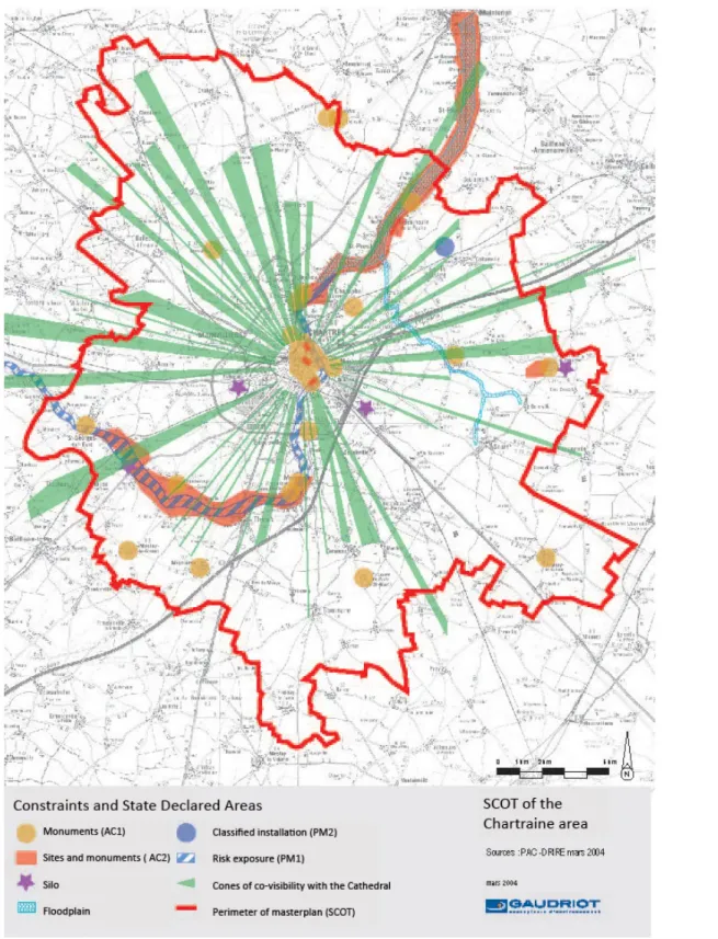
Figure 2: Cartographic representation of the (project of) Cathedral Directive (Source: Schéma de 1
Cohérence Territorial de l’aire urbaine de Chartres, 2004). [The green radiuses represent views from and 2
to the cathedral and were supposed to be protected against any construction project: they are illustrative of 3
the traditional French visual approach to landscape protection.]In order to provide visual protection of the 4
views from and to the monument, the cartographic representation presents the Cathedral in the form of
5
cones radiating into the countryside (Figure 2). The ‘Cathedral Directive’ is symptomatic of the French
6
State’s approach to landscape (Dupont, 1997) in that it emphasizes the visual landscape and its rather
7
tenuous relationship to local interests. This policy of visual landscape is partly rooted in the administrative
8
approach to monuments and their surroundings, which dates from the early twentieth century. It consists of
9
two traditions. The first goes back to the protection of historical monuments (Laws of 19137 and 19438),
10
based on the concepts of ‘surroundings’9 and ‘conservation of monumental perspective’10. The second goes
11
back to the protection of natural monuments and sites (Laws of 190611 and 1930), which aimed at
12
protecting those deemed to be of heritage value12 from any ‘offence against the spirit of the place’.
13
Although the impact of this dual tradition has not been quantitatively significant as to the portion of the
14
territory covered13, it has provided grounds for what might be called a state-landscape. By this we mean a
15
type of naturalization and institutional objectification of the landscape that has evolved since the 1970s14
16
and expanded into a diffuse body of laws about environment, architecture and urbanism
17
Three concepts have been at the basis of this state-landscape: ‘heritage’, ‘co-visibility’ and ‘surroundings’.
18
The idea of ‘heritage’ refers to sites or monuments considered sufficiently important to be part of the
19
French national heritage, that is, part of the ‘common good’. Assigning designation was originally the
20
responsibility of the State and was progressively extended to include a consultation process, notably
21
through public inquiries. The concept of ‘co-visibility’ refers to the fact that a site/monument deemed to be
22
of heritage value and a new project or projects are visible from some point of view, either mutually or
23
singly. This concept has lost some of its exclusive character in the definition of landscape, but it still guides
24
administrative decision-making. Finally, the idea of ‘surroundings’ arises from the premise that the
25
perception of a monument is conditioned by its immediate environment. It contributes to defining visibility
26
by setting a geometrical definition for a state-declared area round the monument. Initially circular (a 500
27
meters radius area), its contour has been changed (successive laws in 1983 and 2000) in order to adapt it to
28
local situations as well as to extend it to protect heritage landscape (in 1993). Planning this area has also
29
become more open to public participation and has evolved from protection to management by including
30
considerations such as ‘charters’ or ‘good practices’ in project development.
31
Such a legislative arsenal proves the importance for the French State of both the visual approach and its
32
delineation in the plan (2D representation) as ways of translating landscape into a ‘public good’. The (sight)
33
line (in the plan) is endowed with the power of ruling, if only because it delineates the space (sub-territory,
34
state-declared area) in which certain branches of the administration are vested with the power of procedural
35
veto for project development. When this is not the case, the administration relies on the co-visibility criteria
36
so as to bring the surroundings into existence as landscape elements: ‘It’s a matter of sight. From the
37
monument, we look at what is happening around it, and from the surroundings we look at what happens to
38
the monument; it works together ... it’s like a jewel and its box’15.
39
The primacy of the visual and the geometry of space thus contribute to endowing this state-landscape with
40
7 Law of December 31, 1913 about ‘Monuments historiques’. 8 Law n° 43-92 of February 25, 1943.
9 Cf. articles 13 bis and 13 ter of the law of December 31, 1913.
10 Law of July 13, 1911, whose legal content is now in art. R111-21 du code de l’urbanisme.
11 Law of April 21, 1906, put into final draft in the law of May 2nd 1930, today codified in the articles L. 341-1 à 22 of the Code de
l’Environnement. ‘Sites inscrits’ and ‘sites classés’ are the two types of protected areas according to heritage considerations. ‘Inscription’ implies a will to keep the site unchanged, whereas ‘classification’ imposes only a duty of informing the administration of any project that could affect the classified area. These ideas were made final under the Law of May 2, 1930 and written into the French code for the environment. The 1930 law is usually referred to as being in the tradition of ‘monumental landscape’: it extended to landscape a type of protection that was already in place for monuments, thus implicitly ‘valuing’ landscape as if it was part of the French monument heritage.
12 In fact, the Law of March 30,1887 instituted the idea of historical heritage. The 1906 law instituted the idea of natural heritage by
protecting the natural monuments and sites.
13 By the end of the1990s, protected sites and important landscapes encompassed 2% to 3% of the French territory. 14 For a detailed analysis, see Barraqué (1985) on the emergence of a landscape administration.
a factual dimension, which in turn legitimises its administrative takeover. The state-landscape punctuates
1
the French territory; it is a landscape made up of a multitude of state-declared areas resembling isolated and
2
irradiating figures. It is these irradiating figures that industrial wind turbines suddenly connect through the
3
far-reaching co-visibilities imposed by their size.
4
3 The rise of wind power: a State off-centre 5
In 2001, the adoption of fixed tariffs for wind electricity secured significant profits for wind power
6
developers in France. It induced them to prospect rural areas intensively in search of sites on which to set
7
up turbines. This led to unprecedented pressure on mayors and local administrations. As the usual
8
construction permit proved irrelevant for arbitrating wind power projects, local authorities responded by
9
devising ad hoc planning schemes. The development of this new and decentralized energy nurtured a lively
10
and active opposition to the technology at both the local and the national level, partly boosted by the feeling
11
that wind power policy was exclusively profit-driven. It was also the occasion of a major controversy over
12
whether or not to decentralize French energy policy. Detailed analysis of the parliamentary debate shows
13
that multiple strategies - including full centralisation (as a means of direct control) or full decentralisation
14
(as a means of putting energy policy in the hands of the then vigorous local opposition) - were successively
15
undertaken by some parties in order to limit wind power development (Nadaï, 2007). As far as planning is
16
concerned, the outcome was a compromise solution in the form of Wind Power Development Zones
17
(WPDZ), which are proposed by local communities but validated by the local representative of the State:
18
the department prefect. Unlike the German or Danish wind power zones, WPDZ are not planning zones per
19
se, but electric contracts that then become planning incentives. They are not translated into urban planning 20
documents (a process which would have involved town councils). Although wind power projects do not
21
have to be located in a WPDZ to be granted a construction permit, they can benefit from fixed tariffs only if
22
they are located in a WPDZ. As such, WPDZ are a type of half-way decentralisation, a de-centring16 of
23
energy policy that is symptomatic of the ambivalence found in French political circles and institutions
24
when it comes to the development of (decentralised) renewable energies.
25
Administrative authorisation for WPDZ as well as for individual projects involves the various ministerial
26
field services (environment, heritage, energy, road and infrastructure). The local (departmental) branch of
27
the Ministry of Culture (SDAP), in charge of landscape and heritage protection, may have an important say
28
in the authorisation process17. The regional environmental field service (Diren), however, has a key role to
29
play as coordinator of the overall administrative process and with respect to notification. While project
30
authorisations tend to follow procedures that have been stabilised since the adoption of fixed tariffs, WPDZ
31
processes have been more flexible. Their devising under the supervision of local communities and
inter-32
communalities have in some cases allowed them to involve non-state entities, such as a local NGO’s or
33
territorial entities (Parc Naturel Régionaux). The extent to which each of these different entities has shaped
34
wind power development depends on local configurations and political will, especially on the part of the
35
prefect of department.
36
31. One centre (Cathedral), many epicentres (wind turbines)
37
In the Eure-et-Loir, wind power build-up was so rapid (in 2003, 12 permits were granted; in 2004, again
38
12; and in 2005, 22) that local administrations often lacked the time for in-depth inquiry and fieldwork.
39
Developers knew the field better than the administration, thanks to intensive prospecting: ‘It works like
40
archaeology, where you discover treasures while working in the field … We discover the potential of our
41
region through the developers’ impact studies’18.
42
Between 2003 and 2005, the Cathedral provided strong and central arguments for not authorising projects
43
that would be sited too close to Chartres to avoid ‘visual competition’ or ‘cluttering up the visual
44
environment of the monument’19. Moreover, in the Beauce, the notifications sent by Diren20 to wind power
45
16 Or déconcentration in French, meaning that, though still under State control, it is approached from the periphery, closer to the local level.
17 The Ministry has a veto power on projects if these are located within a perimeter of 500m around the heritage site. Otherwise, its advice is
only consultatory. As wind turbines create co-visibilities that are far more extensive than the approved perimeter , the Ministry often has little decision-making power (consultatory) in authorising wind power projects.
18 Interview with the Diren Centre, 2006.
developers referred to landscape and spatial problems such as co-visibility (with protected sites or, to a
1
lesser degree, housing areas), encircling of villages and the spatial display or inter-distance between wind
2
farms.
3
But wind power overflowed the boundaries of the state-landscape (as previously defined in §.1) in two
4
important ways. First, the tools for legal inquiry introduced by recent legislations in relation to wind power
5
(impact studies, construction permits, public inquiry) opened landscape assessment to a multiplicity of
6
dimensions that encompassed and went beyond the sole visual dimension of the state-landscape (natural
7
environment, wildlife, heritage, noise pollution and public health issues). As stated by the Ministerial guide
8
on ‘Good practices for Impact Studies’: ‘It would be pointless to try to integrate wind farms into the
9
existing landscape. Landscape preservation in the classical sense is neither possible nor desirable. The
10
challenge is rather to aim at a type of landscape development’ (cf. ADEME and MEDD, 2004:54). On the
11
other hand, in the restricted field of visual landscape itself, wind power suddenly introduced multiple
12
relations, complex and remote connections, which the traditional geometrical zoning could no longer
13
properly regulate. ‘Higher than the cathedral’s spires’21, the turbines acted as genuine sources of visual
14
interactions. They progressively composed a complex net of visual epicentres that landscape protection
15
could neither ignore nor accommodate within the landscape approach. As the Eure-et-Loir
state-16
landscape advisor pointed out, ‘Chartres is a strong reference point for the whole sector… People call
17
“Beauce chartraine” the overall sector dominated by the Cathedral. The problem is that the turbines come
18
and disturb this very idea. At bottom, that’s what is at stake […] Am I the reference point or am I not?’22.
19
The photomontages, which were included in the impact studies, constituted the visual representation
20
through which this new visual landscape was shared and circulated. They were the representations through
21
which turbines were endowed with a visual existence as new epicentres of the Eure-et-Loire landscape.
22
32. Capturing epicentres (photomontage), penetrating the landscape
23
The photomontage has been presented by the French authorities as a flagship tool for assessing the impact
24
of wind power on landscape and as an ‘excellent basis for running concerted decision-making processes’
25
(cf. ADEME and MEDD, 2004: 68). According to good practices, it aimed at simulating the presence and
26
integration into landscape of a future wind farm, as perceived from different points of view. It was thus
27
designed to translate the presence of wind power into landscape as experienced in situ and to circulate this
28
translation. Yet making a photomontage relied on a set of operations (for example, choice of the view,
29
shooting angle, technical parameters such as focal lens, colours, contrast and brightness, and mounting
30
technique) which paved the way for various biases, with the result that photomontages could easily be
31
devised so as to serve the interests of those who developed them. The gradual spread of visual simulation
32
software came to diminish some of these biases23, but could not of course guarantee faithful translation of
33
the in situ experience.
34
A review of the administrative assessments of wind power projects in the Eure-et-Loir between 2003 and
35
200624 shows that it was a period during which the local administration heavily relied on photomontages
36
for decision-making. The administration also endowed this tool with a normative dimension that
37
photomontage could not do justice to given the then existing relation between fieldwork, developers and
38
administration. In practice, the local administration lacked the material means for a systematic follow-up of
39
inquiry in the field. It had to rely on the wind power developers’ capacities for exploration, which had been
40
boosted by the large profit margins yielded by the fixed wind power tariffs. Moreover, in spite of the large
41
number of projects approved, the actual deployment of turbines was slow25. The administration lacked
42
field-references that would enable it to experience the presence of wind turbines in the landscape and so the
43
cumulative effects of the approved projects. In situ experience would have been needed to formulate
44
20 Analysis of administrative notifications, 34 wind power projects, between 2003-2006, based on the construction permits files made
available by the Eure & Loir DDE.
21 Title of the September 21, 2005 issue of the local news paper La République du Centre on the day of the erection of turbines in the wind
farm at Bonneval, thirty kilometres from Chartres.
22 Interview with the State landscape advisor, Region Centre, March 6, 2008.
23 Here we find at work the mechanical objectivity described by Lorraine Datson and Peter Galison (1992). 24 Analyis of administrative notifications between 2003-2006 (cf supra).
requests in adequate terms and induce developers to convey the wind power landscape through
1
photomontages.
2
The first wind farms were erected between 2005 and 2006. A new administrative officer with a background
3
in social science, hereafter called Harold, took charge of these questions at the Diren Centre (which
4
administers the entire Centre region, including Eure-et-Loir, Loiret). Photomontages still played a decisive
5
role, but the administrative notifications indicated a twofold evolution. On the one hand, the administration
6
appeared to grow increasingly critical of the photographic medium itself, while still admitting the relevance
7
of photographic realism for objectivity. On the other hand, new issues relating to the increasing complexity
8
of the landscape recurred again and again in the notifications. For instance, they pointed to visual
9
interactions between wind farms, to turbines close to dwellings, and to a ‘visual saturation’ in the south of
10
the department. Standards also became more exacting with respect to the Beauce as an entity and as a
11
landscape, leading to the refusal of some projects: ‘If all these wind farms […] become reality, this sector
12
of the Beauce will be saturated with turbines. The situation doesn’t appear to us to be acceptable, whether
13
because of its impact on the inhabitants, on wildlife or on the landscape’26.
14
Overall, in this period of the massive increase of wind power projects in the Eure-et-Loir, photomontage
15
failed to communicate both the state-landscape and the presence of wind power in the Beauce landscape.
16
These limitations were particularly rooted in the increased exploratory capacities given by wind power
17
tariffs to developers, who could thus use photomontage to take possession of the visual landscape.
18
4 Re-centering the state-landscape: calling upon the Beauce 19
Two reports written by the local administration bear witness to its response during 2005 (cf. Diren, 2005;
20
Bonneaud, 2006). The first report used a cartography of the visual impact of wind farms approved or under
21
administrative assessment (cf. figure 3) in order to indicate the emergence of a ‘Wind Power Beauce’,
22
where the ‘verticality of the turbines’ would be predominant, and to distinguish between the ‘Traditional
23
Beauce’ (open field landscape, horizontality) and the new Beauce. This was the very first time that Beauce
24
was mentioned as a landscape deemed relevant to policy attention: ‘There will remain hardly a sector of the
25
Beauce left without a view on turbines’27. The second report refined this statement by analysing
ill-26
conceived cases: villages with distorted skylines and an overwhelming presence of turbines as seen from
27
some settlements. The entire approach to the regulation of wind power development was being
28
progressively questioned. ‘The Eure-et-Loir has been a testing ground […]. It is the failure from which we
29
must learn’28.
30
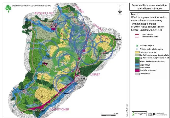
Figure 3: Wind Power Projects construction permits (accepted or under administrative assessment) (10km 31
landscape impact radius) (Source Diren Centre, updated 18/11/2005) [ In 2005, 44 wind projects had been 32
granted construction permits; the local administration represented them on a map, assuming a 10Km 33
visibility radius, and concluded that project authorisations and planning procedures had not properly 34
regulated wind power development]. 35
Focusing on isolated cases and considering the visual perception of wind power from inside the villages
36
(the inhabitants’ point of view) soon raised issues of political legitimacy for the administration (that is, the
37
Diren Centre). As one Diren officer said: ‘What gives us the right as an administration to go beyond the
38
large-scale landscape where our action [as part of the French State] is legitimate [….]? All clues point to an
39
absence of opposition to wind power in the Beauce’29. In other words, if the French State, acting through
40
Diren, has the right to protect the larger landscape, how could it speak for the people about their proximate
41
landscape when the people do not themselves seem to experience the proximity of wind turbines as a
42
problem? This enticed Diren to change strategy.
43
26 Diren Centre, March 24, 2005, technical advice.
27Interview with the Diren Centre civil servant, March 6, 2008.
28Idem. The Beauce covers about 5,740 square kilometers. It encompasses the departments of Eure-et-Loire, Loir-et-Cher and Loiret, that is,
about 1/8 of the Centre Region.
29Ibid. At the end of 2008, one local NGO (kiproko; http://www.kiproko.info/GoogleEarth/Beauce.htm) opposed wind power development in
the Eure-et-Loir. We have not inquired into the absence of opposition to wind power in this case study. However, some interviews indicate that industrial agriculture and farmers dominate the local politics in village and that wind power was perceived by local mayors as part of the private business of industrial farmers.
There were signs in Diren’s two reports that heralded the emergence of a ‘larger’ state-landscape. One of
1
the recommendations of the first study pointed to the importance of ‘not wasting space’30 (for example,
2
making existing projects denser). New concepts emerged such as the need for a distinction between the
3
‘traditional Beauce landscape’ and a ‘Wind Power Beauce’31. Ultimately, the revolution at Diren consisted
4
in reasoning on the scale of the ‘Beauce as a unit’ as well as in seeking new tools and a new approach for
5
planning wind power.
6
Such a shift was all the more surprising as it rested precisely on the lack of concern for the landscape:
7
‘Nobody cares [about the ‘larger landscape’]: our action is therefore legitimate’32. ‘Larger landscape’ was
8
put into a scale in which few individuals would feel committed to participate or for which they would
9
express their spontaneous support. That the administration somewhat downscaled the landscape showed its
10
distancing itself from the public: invoking public interest as a rationale for landscape protection was in fact
11
a way to exit from local politics. Changing landscape boiled down to changing politics: ‘It is as if our
12
interest in the Beauce as a landscape had been aroused by the presence of wind turbines, which led us to
13
rediscover landscape values’33.
14
41. Including the Beauce landscape in a planning approach
15
Re-photographing the Beauce 16
Among the new tools developed to renew the approach to landscape was a photographic observatory aimed
17
at acknowledging the rising interest of local planners in the Beauce landscape.
18
Since 1991, the practice of photographic landscape observatories has been part of the evolution of French
19
landscape policy. It reached its methodological normalisation in a document recently published by the
20
Ministry on Environment (MEEDDAT, 2008). The method aims at ‘the constitution of a library of
21
photographic sequences in order to allow for an analysis of [the] transformation of spaces […] analysis that
22
will be used as a tool to foster a favourable evolution of the landscape’ (ibid., p. 6). Its principle consists in
23
taking photographs of a given landscape and repeating observation of the sequence at a later time (constant
24
framing, periodic repetition of the sequences, planned itinerary). ‘Re-photography’ is the name given to this
25
practice and method. Instead of being a tool for classical comparison (before/after), it aims at setting the
26
conditions for serial observation (constant framing, periodic repetition of sequences, planned itinerary). The
27
photographic observatory preserves a memory of the evolution of landscapes, ‘bringing to visibility the
28
essential elements’ of a territory (MEEDDAT, 2008, p. 33).
29
In 2007, Diren realised that a total of 35 new wind turbines had been authorised in the southern part of the
30
central region (Indre department)34. As they would be installed between 2008 and 2010, Diren decided to
31
launch a photographic landscape observatory to ‘witness’ 35 the rapid mutation of the Beauce landscape in
32
this area: ‘The idea is to observe the accumulation of wind turbines’36. At the time of our research, Diren
33
was only initiating a preparatory phase. It nonetheless provided the occasion for fieldwork. Following the
34
Diren Centre in this phase showed that (in spite of the absence of a photographer at this stage) the
35
observatory not only served memory-keeping and synthesis, but also provided means for adjusting a
36
situated perception of the future presence of wind farms in the landscape and for classifying evolution
37
according to types.
38
Diren still had in its possession the impact studies and the photomontages provided by developers. In the
39
autumn of 2008, an intern at Diren conducted the first fieldwork in order to locate photographic viewpoints
40
for the observatory. He had collected the photomontages from the impact studies and located the
41
30Diren, 2005: 83
31 Ibid: 11.
32Interview with the Diren Centre civil servant, March 6, 2008.
33Idem.
34 Indre is in the southwest of the Beauce, not actually part of the department of Eure-et-Loir. However, the work observed and described in
this area was for the administration an integral part of the planning process and the photographic observatory that covers the Beauce and the Eure-et-Loir.
35Following of the Diren Centre fieldwork, May 16, 2008.
corresponding viewpoints on a map. By combining deskwork and fieldwork, he was able to compile a list
1
of the viewpoints and locate them on a map (as cones of visibility). Equipped with this preparatory map and
2
colour copies of the collected photomontages, the intern, Harold and the Diren landscape architect then
3
went into field. They literally followed in the developers’ footsteps by selecting the most sensitive points of
4
view they had identified. While no wind turbine was yet in place, visual landmarks (water tower, telephone
5
relaying station) provided reference points in the landscape and on the map that allowed the civil servants
6
to keep track of the locations of the future wind turbines. These points also conveyed a feeling of scale,
7
enabling the officials to grasp the future presence of the turbines. Each point of view was the occasion of a
8
discussion and exchange about in situ perception and experience, looking for the exact viewpoint that
9
revealed the way in which the wind turbines would reshape the landscape. This experience was constantly
10
checked against a location in the map, compared to the developers’ photomontages, and standardised
11
through a few indications for the photographer (framing, position in space, shooting angle). In this
12
preparatory exercise, field experience was progressively bringing the photomontages into a new network by
13
relating them to the map, the sites and their atmosphere. State officials were developing a counter-expertise
14
about photomontages. A new State viewpoint was emerging, one that connected wind power landscape
15
representation and planning procedures to the field. Fieldwork also enabled Diren to abandon a perspective
16
attached to the Cathedral and shape a de-centred viewpoint in the landscape, a viewpoint that went beyond
17
‘classified’ heritage and landscape. This provided the administration with a situated experience of the
18
Beauce landscape, with a language capable of potentially making it sharable - the ‘Traditional Beauce’
19
versus ‘Wind Power Beauce’ - and with a project to go ahead with.
20
New principles and new tools for planning the Beauce landscape 21
At the end of 2007, a wind power scheme was under development in the department of Loiret (next to
22
Eure-et-Loir). Diren was invited to participate in it and started experimenting with the new principles,
23
introducing Beauce as a ‘larger landscape’ into the planning categories: ‘We must not think about one wind
24
farm at a time, but approach things on a larger geographic scale and consider how to group farms
25
together’37. For Harold, the experiment with first permit authorizations in the area was very successful. ‘We
26
succeeded in designing an ideal wind power basin […] All we needed then was to invent a label in order to
27
say that this was what we also wanted to have elsewhere’38. He saw the experiment as providing the basis
28
for a model of regulation, which translated the Beauce landscape into two concepts and elements – ‘wind
29
power basins’ and ‘breathing spaces’ – which enabled the administration to regulate wind power
30
development in accordance with visual principles. In a basin, ‘the wind farms are sufficiently close [to each
31
other] to be perceived as an ensemble’39. Complementary to the basins, the breathing spaces allowed the
32
administration to ‘[confine and group] the wind turbines within well-defined spatial envelopes and to
33
reduce their visual impact on the larger landscapes’40. Interviewed about ‘breathing spaces’, an officer said:
34
‘[…] when you look at the other side of the road, you have turbines, but they are in the distance, so you
35
have this effect of breathing. It is this faraway [in French ‘cet au loin’] that has to be protected […] We do
36
not define breathing spaces as zones where one sees no turbines; we define them as zones where the visual
37
pressure of the turbines decreases’41. This new approach also provided a solution for how to make new
38
wind power developments compatible with both the preservation of the state-landscape and the already
39
existing and planned wind farms.
40
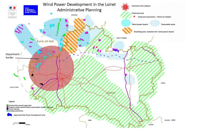
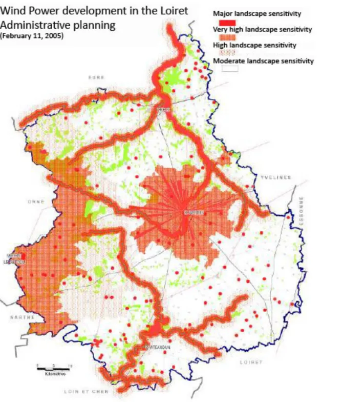
Figure 4: Wind Power Development in the Loiret – Eure-et-Loir Wind Power Scheme, 2008 [The design of the Loiret planning scheme, which was concomitant with that of the Eure-et-Loir, gave the local administration with an opportunity to design wind power basins (light blue) and breathing spaces (orange
37Interview with the Diren Centre civil servant, March 6, 2008. 38Interview with the Diren Centre civil servant, October 3, 2008.
39DDE du Loiret (Janvier 2008) Développement éolien dans le Loiret. Les orientations de l’Etat. « Vers la constitution de bassins éoliens ».
http://www.loiret.equipement.gouv.fr/IMG/pdf/annexe_cle13e2d2.pdf
40Idem.
41 Interview with the Diren Centre civil servant, March 6, 2008.
In this quotation, the officer employs an unusual, grammatically incorrect but intentional use of the adverb ‘au loin’ (meaning ‘faraway’) as a substantive to translate the perception that this landscape conveyed ‘a breathing effect’ (sic: ‘un effet de respiration’). This rhetorical form is not neutral. Nominalization literally turns the experience of ‘breathing’ into a landscape element, which was later to be translated into an (unusual) planning category: the ‘breathing space’.
stripes) which straddled the administrative border (top left of the map)].
During this period (autumn of 2007), a new prefect was nominated in the Eure-et-Loir. He declared ‘that
1
the department had already done enough for renewable energy in this country. There’s no need to do
2
more’42. He also ordered the local administration to revise the Eure-et-Loir wind power scheme (issued in
3
2005) and to base the new scheme on ‘harder standards’.43.
4
Figure 5: Landscape Sensitivity – Eure-et-Loir Wind Power Scheme, 2005 [In 2005, the first wind power scheme in the Eure-et-Loir was based on a visual approach and represented zonings for visual protection following the valleys, the frontier of the regional natural park (PNR, left part of the map) and the radius of the Cathedral Directive].
For Diren, this political event provided a window for enlarging the planning principles that had come out of
5
the Loiret experience. The scheme was strengthened by various means (20 km protection radius around the
6
Cathedral, extending buffer zones around valleys), including the creation of three wind power basins in the
7
south-east of the department. These three basins were separated by a zone of lower density called a
8
‘breathing space’.
9
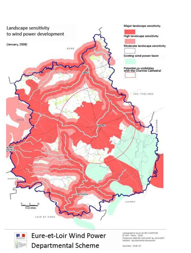
Figure 6: Landscape Sensitivity – Eure-et-Loir Wind Power Scheme, 2008 [ In 2008, the second wind power scheme included existing wind power basins (in light blue) and landscape sensitivities. These elements are represented by coarser graphic forms (figuring buffer zones, large circle around Chartres, in red). This is an attempt to account for the Beauce landscape and its large scale as well as to concentrate wind power development in the existing basins rather than to seek a detailed and territorial delimitation of zonings].
As this process was concomitant with that of the Loiret, it provided Diren with an opportunity to design
10
wind power basins and breathing spaces that straddled the administrative border. This resulted in a coherent
11
planning on the scale of the Beauce. The new Beauce basins and the breathing spaces did not outline
12
zonings in a proper sense. They were translated in the map as somewhat shapeless forms that did not
13
indicate geometrical or territorial areas and did not clearly delineate an inside and an outside (see figure 6).
14
The design of these graphic forms was justified in terms pointing to sensation and visual experience in
15
relation to the presence of wind power in the landscape. The terms called attention to the logic of the
16
situation, such as the possibility of perceiving from a certain perspective an expanded Beauce landscape in
17
which the presence of wind turbines could remain marginal. The administration’s arguments against
18
developers’ attempts to propose new projects within these breathing spaces showed how sensation, as an
19
experience of the presence wind power, continuously circulated between visual experience and planning: ‘
20
[…] there is a real physical boundary between the wind power basin and the breathing space […] Going
21
from Orléans to Paris by train or by state road 20, one sees all the turbines on one side all the way. They are
22
all on the west side. To the east, one sees today a landscape without any turbines […] We said we found it
23
rather interesting to have an industrial wind farm landscape on one side and a more traditional Beauce
24
landscape on the other’44. While shifting to the ‘larger’ state-landscape, Diren was also changing its way of
25
devising and organising this state-landscape. It was no longer based on metric relationships between
26
heritage elements and their surroundings (radius, visual cones, co-visibilities), but on rhythms, contrasts
27
(left side/right side of the road) and differences (the traditional Beauce/the Beauce of industrial wind
28
farms). Because the approach had become less formal, it was more open to concepts such as density,
29
saturation, breathing spaces (preserving a ‘far away’) and made it possible to introduce the language and
30
practice of experience into the core of planning.
31
Loose lines, shapeless forms and experiential concepts, however, also made it harder to share the logic of
32
planning with developers. Though a process seemed to be set in motion, it remained extremely fragile, as
33
could be seen in developers’ attempts to move into the planned breathing spaces. This seemed to call for a
34
42Statement quoted by La République du Centre, July 10, 2008. 43Interview with the Diren Centre civil servant, March 6, 2008.
form of sharing and legitimacy that went beyond the scope of a single administration.
1
42. Excluding the public from the Beauce landscape
2
Participation in devising wind power development zones 3
Wind power development zones (WPDZ) were the institutional setting in which the new planning scheme
4
could have been brought under the umbrella of more open governance. WPDZ have to be proposed by
5
groups of local communities and approved by the department prefect (see §3). The way in which they
6
actually work after 2007 in different French departments has depended on the interplay between the
7
political authority of the prefect and the initiatives of local communities and inter-communalities. Some
8
prefects have imposed a political process by requiring all WPDZ proposals to be drawn up by several
9
communities and turned in to the administration before new project authorisations would be granted (for
10
example, Nadaï & Labussière, 2009). Other prefects did not; they accepted that WPDZ processes remained
11
technical and usually recycled the impact studies of individual wind power projects in a new administrative
12
format, with no requirement of inter-communal participation or agreement.
13
In the Eure-et-Loir, the WPDZ processes followed this second route. Some were steered by the main land
14
owners (farmers) and followed a rent-seeking logic, allocating wind power zones so as to satisfy individual
15
demands in the community. Others worked along a purely ‘technical’ line, outsourcing the treatment of
16
wind power issues to a private landscape company so as purportedly to avoid political tensions, but without
17
devising landscape/territorial projects. In both cases, Diren was faced with difficulties in sharing the new
18
visual landscape, either because of the ‘rent seeking’ logic or the limited means allocated to landscape
19
companies for their work. The result was that local governance failed to provide the new wind power
20
scheme with legitimacy.
21
Participation in authorisation processes 22
Procedures for project authorisation also failed to contribute to citizen participation in decisions on wind
23
power development. Like many other local administrations when wind power started to take off in
24
France45, the Eure-et-Loir administration progressively divided the procedures for project authorization into
25
two branches, called by the local officers themselves the ‘technical branch’ and the ‘political branch’. The
26
first branch covers the assessment of the construction permit and the impact study; the second includes a
27
public inquiry (on the basis of the impact study, publicly posted in the town for a month) and the
28
opportunity for citizens directly to petition the prefect. Both branches intersect at the level of the prefect,
29
who gives a final ‘political’ decision on the basis of three types of evidence: the administrative notification
30
(based on the construction permit and the impact study, usually coordinated by Diren), the report of a
31
commissar (based on the public attendance and petitions during the public inquiry) and the direct petitions
32
that any citizen can send to the prefect. Either side can appeal the decision of the prefect in the
33
administrative court. In the case of wind power, this is often the case: either ‘opponents’ of wind power or
34
developers appeal the final decisions. As a consequence, local ministerial field services have come to see
35
their role in these processes as one of producing notifications that can resist judiciary attacks, so that
36
prefects basing their decisions on these notifications have a chance of getting them confirmed in the
37
administrative court.
38
These procedures have had three major consequences. The first is that they set an early interaction with
39
developers while relegating public consultation to the political branch and to the last phases of the process,
40
when projects have already been made final. As has been indicated in the planning literature (cf. Healey,
41
1997), this tends to form the public into opponents by giving it only the possibility of reacting to finalized
42
options. Second, as far as landscape is concerned, administrative notifications anticipate the judicial
43
process and base their arguments on categories and norms that are infused with judicial values. This
44
landscape, which some officials have come to call the ‘opposable landscape’, is mainly made up of sites
45
and monuments endowed with shared patrimonial values and comes down to what we discussed as the
46
state-landscape in §1. Third, the procedures are a powerful way of objectifying decisions while keeping the
47
public at a distance. In the early years of wind power development, officials eventually attended public
48