Publisher’s version / Version de l'éditeur:
Economic Geology, 48, 7, pp. 513-540, 1953-11
READ THESE TERMS AND CONDITIONS CAREFULLY BEFORE USING THIS WEBSITE. https://nrc-publications.canada.ca/eng/copyright
Vous avez des questions? Nous pouvons vous aider. Pour communiquer directement avec un auteur, consultez la première page de la revue dans laquelle son article a été publié afin de trouver ses coordonnées. Si vous n’arrivez pas à les repérer, communiquez avec nous à PublicationsArchive-ArchivesPublications@nrc-cnrc.gc.ca.
Questions? Contact the NRC Publications Archive team at
PublicationsArchive-ArchivesPublications@nrc-cnrc.gc.ca. If you wish to email the authors directly, please see the first page of the publication for their contact information.
NRC Publications Archive
Archives des publications du CNRC
This publication could be one of several versions: author’s original, accepted manuscript or the publisher’s version. / La version de cette publication peut être l’une des suivantes : la version prépublication de l’auteur, la version acceptée du manuscrit ou la version de l’éditeur.
Access and use of this website and the material on it are subject to the Terms and Conditions set forth at
An engineering study of glacial deposits at Steep Rock Lake, Ontario,
Canada
Legget, R. F.; Bartley, M. W.
https://publications-cnrc.canada.ca/fra/droits
L’accès à ce site Web et l’utilisation de son contenu sont assujettis aux conditions présentées dans le site
LISEZ CES CONDITIONS ATTENTIVEMENT AVANT D’UTILISER CE SITE WEB.
NRC Publications Record / Notice d'Archives des publications de CNRC:
https://nrc-publications.canada.ca/eng/view/object/?id=85ea7f99-2bb9-4b98-b3a3-6d4dc1a2d5f1 https://publications-cnrc.canada.ca/fra/voir/objet/?id=85ea7f99-2bb9-4b98-b3a3-6d4dc1a2d5f1
Abstract . . . Introduction . . . Stratigraphic succes
Draining of the Lake . . .
Some comments . . . Conclusion . . . Bibliography . . . . . . Appendix ABSTRACT.
Steep Rocli Lake, in Western Ontario, was drained in 1943-44 by means of a large pumping operation. A s the water line dropped, serious move- ments of the exposed soil occurrcd. Study of these, in connection with the develop~nent of the open pit froin \vhich the ~ a l u a b l e iron ore was to be mined, led to an extensive soil investigation. T h e varved "clays" revealed by the mining operations with a total thickness of over 100 feet were studied first with engineering objectives in view. These "soil mechanics" investi- gations led to a detailed study of the soil in individual valves. Results con- firm several features of the well-known seasolla1 theory of deposition but raise some questions which suggest the desirability of carrying still further this laboratory soil research.
INTRODUCTION
STEEP R o c k L a k e is located near t h e e a s t e r n e n d of t h e R a i n y River District, about 140 iniles west of P o r t A r t h u r , O n t a r i o , C a n a d a ( F i g . 1 ) . T h e a r e a
Source bf iron
xecution of some
L. N I P I G O N
FIG. 1. Key map of location.
outstanding civil engineering works in order to divert the flow of t h e Seine
River from the Lake, which was thereafter drained by means of a pumping operation of epic proportions ( 1 1 ) .
T h e Lake had an area of about seven square miles ; it was drained t o a depth
of over 140 feet below original water level. As the water level fell, the lake-bed
deposits were exposed. At first they were uilstable and inany slides occurred.
These drew attention to the need for a detailed study of the material consti-
tuting the lake bottom, many millions of cubic yards of which have had to be moved and controlled in connection with the open-pit mining operations (Fig. 2 ) .
The slides revealed the varved structure of the extensive bed deposits. This has been studied concurrently with the necessary engineering investiga-
GLACIAL DEPOSITS AT S T E E P RGCIC LAICE, ONT. 515 tions of the soil. Even though the studies of this and other features of the local glacial geology have naturally had to be correlated with work directly re- lated to mining operations, the authors a r e advised that their geological oh- servations have revealed features of solme interest. This general paper has
therefore been prepared with a dual purpose in view. F o r geologists, it re-
cords briefly the developillent of the Mine after the draining of the Lalce and
FIG. 2. General view of open pit workings.
FIG. 3. Section through end nloraine at "esker cut."
suillmarizes the necessary engineering soil studies which have had to be made in achieving this result. T h e results of these studies appear to have some geo- logical significance. F o r engineers, the paper presents a summary of the work in the field of soil mechanics necessary for the carrying out of an unusual ex- cavation job and shows the scientific significance of this utilitarian task. Against the general haclcground thus provided, it is planned to publish as soon as possible further detailed papers dealing respectively with specific aspects of
516 ROBERT I;. LEGGET A N D M . W . B A R T L E Y .
the engineering and geological studies. I n aiming at a dual objective, the
~ u t h o r s have had admittedly to sacrifice some of the features that are desirable
both in engineering and geological papers. If, however, the rapidly expanding field of engineering geology is t o be well served by written records, it would appear necessary t o produce some papers of this general character.
Although not now connected directly with the Steep Roclc projects, the authors were privileged t o be intimately associated wit11 its development until 1947, respectively as a consultant on special soil problems from the start of the dem-atering early in 1941, and as Chief Geologist fro111 1940 and later Produc- tion Engineer. Their interest has continued and they have been privileged
to lceep in touch with developn~ents by repeated visits since 1917. T h e Mine
authorities have always talcen a lively interest in glacial geological features, as well as in the hardrock geology which is of such direct concern to their opera- tions, and they have kindly authorized the publication of this paper. T o i\/I. S. Fotheringham, President, to Watlcin Samuel, Consulting Engineer, and to Hugh Roberts, Consulting Geologist, the authors wish t o express their thanks for stimulating encouragement.
S T R A T I G R A P H I C S U C C E S S I O N .
The area in which Steep Roclc Lake is situated is typical of the Precam- brian Shield of Canada. I t consists of rolling country, with many small lakes and rivers, the exposed bed-rock being glaciated to a uniforln peneplain. The lowlands and depressions between outcrops of bed-rock cradle varying thiclc- nesses of till, sand, silt and clay. These are conformable witl~in themselves but unconformably overlie the Precambrian.
The superficial deposits consist of glacial till or boulder clay ancl drift 1)oulders presumably deposited by the continental glaciers : stratified fluvio- glacial sands and gravels deposited from melt water streams; and glacio-la- custrine silt and clay deposits laid down in lalces formed during the retreat of the ice sheets. These are all overlain by recent deposits of alluvium and peat.
L I T H O L O G Y .
The houlcler clay consists of unsorted material composed of angular, suh- angular and sub-rounded boulders of all sizes set haphazardly in a matrix of sand, roclc flour and some clay. Many boulders show well developed facets, collmmonly striated. T h e till is generally colored red-brown ancl coiltains a considerable number of hematite and limonite pebbles.
Closely associated with the till is a series of rudely to well-bedded sands and gravels presumably of fluvio-glacial origin. T h e material consists of water-worn pebbles and grains representing all of the adjacent bed-rock roclc types. T h e sand and gravel deposits overlie the till.
T h e thickest deposits encountered anywhere in the area are the well lanii- nated varved silts and clays of glacio-lacustrine origin. These are charac- terized by their regular bedding. They vary in thiclcness from a few feet to at least 200 feet. I t is this varved material in the old lake-bed that has been
G L A C I A L D E P O S I T S A T S T E E P ROCK LAICE, O N T . 517
studied so carefully. A later section of this paper therefore deals with it in some detail.
Final deposition was a relatively thin mantel of unstratified alluvium, com- posed in part of rock flour and in part of gumbo clay. While this inay be of lacustrine and fluvio-lacustrine origin, its location and character suggest that it is more likely to be a recent flood-plain deposit.
SUCCESSION O F EVENTS.
I n the Steep Rock Lake area there is evidence of glacial advances from at least two directions. The earlier came from the northwest and north, prob- ably from the direction of the Keewatin center of glaciation. The later ad- vances were from the northeast. from the Labradorean center. The second advance was the stronger and all but obscured the original striae.
The strong Keewatin advance that deposited calcareous debris over inuch of the western section of Rainy River District, apparently died out before reaching the region under discussion. There are no calcareous tills in evidence. It is believed that a feeble lobe, bearing little if any material, overrode the Steep Rock Lake area and retreated without depositing appreciable debris.
The advances from the Labrador center were repetitious in nature, the original and greatest advance overriding the whole of the area, and depositing a general ground moraine. Subsequent readvances terminated farther north,
forming end moraines imn~ediately south of Steep Rock Lake and at the south
ends of Finlayson and Marinion Lakes, north of Steep Rock Lalte. The mo- raines are composed of unsorted till topped by a veneer of boulders. Associ- ated with the retreats were glacial streams and ponds from which consider- able fluvio-glacial deposits of sand and gravel were formed. These deposits are abundant south of Steep Rock Lalte where kames and outwashes rest dis- cordantly on the morainal till.
A glacial lake of considerable size and depth succeeded active glaciation. Suspended sediments carried into the Lalte were deposited as varved sediments. Antevs, during his study of the deposits in 1946, recognized eight distinct series of subdivisions within the varve sectioil ( 1 ) . H e accounts for the eight divi- sions by postulating four readvances and retreats, bringing in new volumes of silt and clay each time. The glacio-lacustrine deposits appear to be, in general, chemically and illineralogically constant for each series, indicating that the
source of the materials was common. 11: is believed that this source was the
region eroded by the Labradorean lobe. Further, it is evident from the extent of the sediments that they were deposited in a standing body of water of con- siderable size, Lalte Johnston being the name for this suggested by Antevs. Beaches and varve material are noted at Elevations of 1275 and 1283 feet ab- solute, with beaches as high as Elevation 1363.
The execution of the civil engineering works associated wit11 the develop- ment of the Mine exposed a number o f sections through the superficial de- posits, which have been described in general terms. The end moraine a t the south end of Finlayson Lake (erroneously called an eslter in local practice), for example, had to be cut through to form part of the new channel for the
518 R O B E R T F . LEGGET AATD M . W . B A R T L E Y
Seine River. Apart froin giving a reinarltable cross-section through the mo- raine (Fig. 3 ) , the excavation revealed no unusual features.
I t is, indeed, sotnewhat surprising that despite all the excavation work which was carried out, only one unusual feature was observed. This is shown in Figure 4, a case of apparent faulting in the face of a gravel pit opened in a ltame deposit in 1943, immediately to the south of the Lake. T h e usual ex- planation of such apparent signs of faulting in uncoi~soliclated material is that they are the result of the melting of buriecl ice-blocks. Having carefully ex- amined the exposed face shown in this photograph, the authors are unable to
FIG. 4. Minor faulting in sand and gravel.
accept this explanation of the sharp shear failure planes. They are convinced that they constitute evidence of recent earth movement at this location, small
in degree but similar ill its effects to major earth deformation.
DRAINING O F T H E LAKE.
T h e draining of Steep Rock Lalte somewhat naturally revealed extensive glacial deposits. A discussioil of their character coilsitutes the principal part of this paper. The draining of the Lalte may therefore be described in some detail.
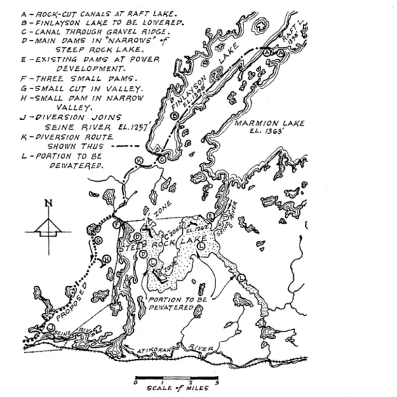
Figure 5 shows a general plan of the Lalte. N-shaped, it had a total length
of 15.5 miles and an origii~al water area oi seven square miles. T h e Seine
G L A C I A L D E P O S I T S A T S T E E P ROCK L A K E , O N T . 519
ect, completed late in 1943, the river flow was led into Finlayson Lalte and so
into the west arm of Steep Roclr Lalte. A cofferdam ('D' in Fig. 5 ) and an
existing concrete dam and power house then isolated the other two arims of the Lake, pernlitting the start of drainage operations.
-
0 2 I I 3
S C A L E -f M I L E G
FIG. 5 . General nlap of Steep Rock Lake.
Geophysical prospecting and intensive diamond drilling off the ice had
located three iron-ore bodies beneath the bed of the Lalte, designated 'A,' 'B'
and 'C'. T h e 'B' orebody was the first to be mined but it lay beneath 100 feet
of water s o the pumping project was one of magnitude. Fourteen 24-inch electrically driven pumps started on the task in December 1943. By the be- ginning of April 1944, the water level had been lowered by about 75 feet.
520 ROBERT F. LEGGET A N D M . W . B A R T L E Y .
Throughout the winter, the surface of the Lalce had remained frozen, even though the ice cover was naturally broken. The lake-bed deposits along the more shallow parts of the Lalce were siniilarly covered with ice and snow.
As the spring thaw progressed, however, not only was this protective frozen covering removed from the exposed bed deposits, but the melting snow from the area draining into the Lalce started to run down towards the Lake. Instead of merging, as previously, into the waters of the Lalte, this run-off had now to seek lower levels and in many cases seeped down beneath the shore deposits. As it emerged, it disturbed the stability of tlie slopes which had stood for so long under water. Many extensive "land-slides" took place and it was then
that the cliaracter of the soils in the lalte-bed was first revealed ; it was then
that this detailed study commenced.
The modern engineering study of soils has made clear that landslides can be analyzed scientifically and generally classified. Application of sucli studies to the mass inovenients at Steep Rock Lalee shows that when the water-level in the Lalce was drawn down relatively suddenly, the factor of safety against failure of the slopes was greatly reduced and even made inadequate. Before draw down, the effective weight of soil in the slopes was the submerged or unit weight of the material. Failure in these slopes tends to take place along a cir- cular arc and is due to the disturbing moment produced by the weight of the segment of inaterial within the circular arc. After the draw down, this weight was approximately doubled and this increase in disturbing moinent hrought about complete slipping and failure of some slopes. This type of circular arc failure was seen at various locations around the Lalte.
"Mud runs" were also prevalent, and were caused by percolation of ground water from the area adjacent to the Lalte. The level of the groundwater table adjacent to the Lalee rose in wet periods. This resulted in an increase in the pressure of the porewater in the coarser layers of the varves. The increased porewater pressure reduced the effective pressure, and tlius the shear strength of the clay, so bringing about instantaneous failures in the slopes. Slides of this nature have heen fully reported in the varved clays of the Hudson Valley
(8) ancl described by Terzaglii (12).
By the end of 1944, the water-level had been lowered by ahout 140 feet and it has reiliainecl at about this elevation since that time. About 520 acres of the Lalce bed in tlie vicinity of the 'B' orehody have been exposed. About 26.5 millioii cubic yards of the soil have now heen removed, largely by dredging and pumping. Slopes and benches have been developed in this area to ail extent that has permitted the worlcing of the ore from an open pit now 3600 feet long, and 700 feet wide, and extending to a depth of 450 feet below the old lake level. Almost seven millioil tons of high grade iron-ore have been removed during seven working seasons. Concurrently, study of the exposed soils has con- tinued at the Mine ancl in various laboratories. The senior author carried out the early soil investigations while on the staff of tlie Uiliversity of Toronto. During the sunliners of 1948, '49 and '50 a member of the staff of the Division of Building Research of the National Research Council of Canada has spent some time-at the Mine especially to study the soils exposed.
G L A C I A L D E P O S I T S A T S T E E P ROCK LAICE, O N T . 521 LAICE-BED DEPOSITS.
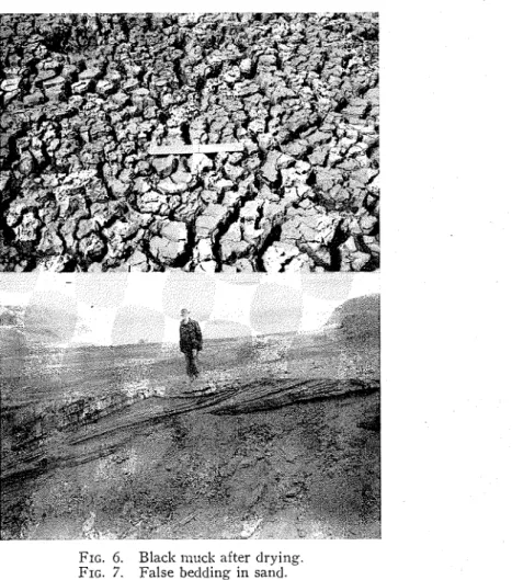
As the ice and snow gradually disappeared in the early suillnler of 1914, the shallower portions of the old lake-bed caine into vielv, slowly increasing in extent as the water-level was lowered by the coiltinuous pumping. Prac- tically the whole of the exposed area was found to be covered by a blaclc ge- latinous-looking deposit, which was extremely unstable when wet and which appeared to be organic. T h e material was similar to the blaclc "ooze" which is a feature of many northern lake bottoms. Its uniformity and generally shallow depth suggested a relatively recent origin.
Since this material was q~iiclcly reinoved from the areas that had to be dis- turbed, and elsewhere quiclcly dried up, forming the bed for the vegetation that has been developed wherever possible as a surface stabilizer, it was not studied in any detail. Extensive shrinlcage cracks developed upon drying
+Loss of ignition a t 550' C for 7 ho~irs.
++ Calcium and magnesiuln val~ies represent water-soluble determined by turbidimetric a n d
colorilnetric mcthods res1)ectively. Potassium irlcludes water-soluble ancl that easily eschange- able by s o d i ~ ~ m nitrite extraction and turbirlimetric estimation by cobalt-nitrite method. Phos- phorus-soluble in 0.05 N HCI determined calorimetrically.
+ + + N o t determined, a s general character of salnple and low loss on ignition value woulcl indicate little or no active organic matter.
Nole: These analyses were kindly carried out by Dr. G. H. Ruhnke of the Ontario Agri- cultural College, Guelph, Ontario.
T A B L E 1.
(Fig. 6 ) . A chemical analysis gave the results sl~own in Table 1. The low organic content is to be noted in view of the black appearance of the material. The blaclc inuck generally overlay the varved clay except along the shallo\v south shore of the Lake. H e r e sand deposits, of a few feet in thiclcness, were common. T h e sand was uniform in grain size, being obviously water de- posited ; in places it exhibited pronounced false bedding ( F i g . 7). This would not he remarlcable were it not for the fact that the direction of flow iildicated by tlle bedding was almost exactly at right angles to that ot the flow through the Lalie. These sand deposits in the lake-bed were sinall in estent, relative to the Lalie as a whole, and so are probably not unduly signif cant. They show, however, how complex must have been the recent geological history of this and similar regions.
Practically all the unconsolidated material in the lalie-bed consisted of varved clays. These are of such importance that they are dealt with in some detail in the next section. I n the stripping worli carried out adjacent to t h e open pit, the varved deposits have in places been reinoved down to the under-
S a m p l c "Black Muck" Grey Silt Moisture 9.267, 2.4y0 i ~ ~ ~ ~ i ~ ~ + 17.13% 2.32y0 .4c t i \r,c organic matter 10.75% -+++ E a s i l y soluble++ Ca P P ~ 500 SO0 M& P P ~ 35 50 K P P ~ 80 100 P P P ~ trace 1 SO
522 R O B E R T I;. LEGGET A N D 1M. W . B A R T L E Y .
lying bed-rock. I n a number of locations, and in all cases where there was any protuberailce above the general level of the glaciated rock surface, a few feet of compact glacial till was found between the rock and the first varved material. The results of preliminary diamond drilling suggest that the till is fairly widespread over the rock beneath the old lake-bed.
FIG. 6. Blaclc illuck after drying.
FIG. 7. False bedding in sand.
No unusual features were noted in the till, apart from its striking red color. Figure 8 presents a sununary of the mechanical analyses which have been made of till samples, which have been quite uniform in character.
T H E VARVED CLAYS.
Practically all the soil exposed in the drained lake-bed consists of banded
sediments of the type commonly described as "varved clays." This descriptive term is therefore used generally throughout this paper although, as will be
G L A C I A L D E P O S I T S A T S T E E P ROCK L A K E . O N T . 523
shown, it may not be tern~inologically exact. I n the vicinity of the 'B' orebody,
the scene of all the mining operations until 1951, varved clays were exposed from about Elevation 1155 to Elevation 1050. The exposures thus constitute one of the most extensive examples of varved clays on record.
Dr. Ernst Antevs was fortunately advised of the exposures and paid a brief visit to the Steep Rock Mine in the summer of 1946. T h e senior author hacl the privilege of accompanying Dr. Antevs during the first part of his field in- vestigation and of describing to him some of the studies dealt with in this paper. With the assistance of a grant froin the Geological Society of America, Dr. Antevs prepared an extensive report on the varves that he examined and in his paper was presented his interpretation of their deposition in accordance with the well known seasonal theory ( 1 ) .
L I U I V A L L N T GRAIN VIkMLTE& (MM.) I NO. OF MESHES PER IN. (u.s.s. SIEVE SERIES) I S I Z E OF OPENING (IN.)
FIG. 8. Mechailical analysis chart for till
I n view of the detail with which D r . Antevs has measured the varves throughout the complete profile that he examined, it is not necessary to give details in this paper. Attention may rather be directed to soille of the features of the varving that seem to be significant in an engineering sense. Soille lab- oratory tests that were made for engineering purposes will then be described. The earth movements that started as soon as the lalte level was lowered in 1944, and which have persisted irregularly ever since, naturally involved large volumes of the varved clays. All the major "mud-runs" that were studied were found to be due to a weakening or loosening of an underlying stratum or varve by the percolation of groundwater from the area draining into the Lake. This percolation could only be appreciable along a relatively porous band. Upon further study, it was noticed that a few thin sandy layers of widespread uniformity were to be found interspersed within the varved clays.
524 ROBERT F . LEGGET rli\TD ill. kt.'. BARTLEY.
T o the existence of these layers of sand can be attributed nlost of the initial soil movements that originally hampered the mining operations.
Another feature of some of the illass n~ovenlents has been the exposure, after a mud-flow has occurred, of singularly smooth surfaces over whicll movement has taken place. T o some extent these might be attributed to the elfect of the moving soil upoil that which stayed in place. Since, however, it is allnost impossible to differentiate by eye between the soil that inoves and that which does not (in the vicinity of a slide), and since the sliding surface
often amears froill a distance to be so clean as to he ~~olished. A L it seeAns clear
that these surfaces represent some discoilforinity in the deposits.
This suppositioil seems to be coilfirmed by one example, seen by the au- thors, in which a large illass of soil having origiilally a flat suriace suddenly flowed through a relatively small gap, when its ldwer end was d i s t u r ~ ~ e d . When moven~ent had ceased, a large area was exposed which appeared, even
from a distance of about a hundred feet, to be a smooth glaciated rock suriace,
curved on its surface with a sharp edge sloped at about 45" to the horizontal.
Figure 9 gives an impression of this surface.
Another significant feature (which has been found elselvhere in glacial lake deposits) is the occurrence, regularly in the lower varved deposits, of flat lens-like calcareous concretions. They are always found in the light-colored
layers. These appear to have formed around nuclei and their sug-
gests the existence, at the time of the deposition of the relevant varves, of water highly charged with calcium salts (see Appendix). I t is of more than passing interest to note that similar concretions have recently been found in the ex-
tensive mud deposits at the mouth of the Fraser River, British Columbia. .
This iinportailt waterway is one of the largest rivers discharging into the Pacific Ocean. I t does so through a large estuary wherein troubles with sedi- ment deposition have long persisted. I t is coinmoilly thought that the deposi- tion of such large volumes of sediment in the tidal part of the river is due, at least partially, to the flocculation produced by sea ivater. The occurreilce of concretions in both locations suggests a similarity between processes of depo- sition.
Another feature of the varved deposits that calls lor mention is the variation in color between the lower and upper deposits. All the sediments at first re- vealed beneath the top cover of black muck, had the dull grey color so typical of alillost all clay deposits. When, however, bed-rocli was appi-oached, I-ecl coloriilg in the clay appeared. The lowest deposits oi all were nearly as deep red in color as the orebody itself, the gradation froill red to grey being gradual. As the color of the soil changed, so did its general character, the red-col- ored varves being generally coarser grained than the overlying grey sediments. This variation in grain size was reflected in a number of ways, the inost im- portant froill the engineering point of view being an increase in instability. When suddenly exposed to view, as by the cutting operation of the hydraulic jets used in the excavation, the red deposits frequently disintegrated rapidly for some distance back from the surface exposed. This is understandable with a silty or fine sandy soil in which the pore pressure of the entrained water is suddenly reduced.
G L A C I A L D E P O S I T S A T S T E E P ROCK L A K E , O N T . 525 I n discussions of varved clay deposits and in detailed accounts of varved profiles much is made of the differences between different bands through- out the cross-section under study. I t may, therefore, be useful to note that an equally dominant feature of the Steep Roclc soils is the uniforn~ity of many of the sections through varves that have been revealed by excavation and the
extensive earth movements. Fig. 10 is typical of the appearance of many of
FIG. 9. Surface of clay exposed after a "mud-run."
FIG. 10. Cross-sectio11 through uniform varve deposits.
the exposures examined repeatedly by the authors. I t will be seen that there are no "light and dark" bands, as usually reported in accounts of varved de- posits. The regularity of the very thin laminations is notable. Oilly when dried did such material exhibit any variation between material in adjacent layers.
I t must be emphasized that all the observations herein recorded are supple-
mentary to those usually made of varved soils-the usual alternate banding,
526 R O B E R T I;. LEGGET A N D ilf. W . B A R T L E Y .
Steep Rock soils by Dr. Antevs. T h e most unusual feature of these soils, however, has yet to be mentioned, this being their behavior when disturbed. Reference has been made to the mud-flows or mud-runs that have caused many of the large inass earth movements, which originally led to such serious inter- ference with the normal process of excavation at the Mine.
Many, if not all, of these appear to have been initiated by groundwater seepage disturbing the equilibrium of soil previously stable in the bed of the Lake. All have involved large quantities of the varved clays, some of the larger slides transporting up to half a million cubic yards of inaterial through distances up to half a mile in the course of a very few minutes.
FIG. 11. Stream of disturbed clay.
Although evidence of moveinent is to be seen, incidentally, in some of the photographs that acconlpany this paper, Figure 11 has been included to illus- trate this soil movement in a typical, although limited, example. The streaim of "mud" here seen is actually flowing towards the remainder of the Lake (in the background) at a slow but quite perceptible rate. The material was that being duinped as individual bucketfuls by a inechanical "drag-line" excavator immediately behind the photographer (the senior author). This heavy ma- chine had considerable difficulty in inoving its bucket into the stiff grey varved clay that it was excavating for road construction, and similar difficulty in get- ting the sticky inass to shake loose of its bucket. But when once dumped, the apparently solid material "liquefied" as one looked at it and flowed smoothly away to join in the viscous stream on its way down the hill.
In an exactly similar way, when once one of the big slides or runs started, the entire mass of soil above the point of first movement appeared to become liquid and flowed rapidly, often through quite restricted openings, until the
G L A C I A L D E P O S I T S A T S T E E P ROCK L A K E , O N T . 527 configuration of the ground dammed up the viscous fluid. I n a relatively short interval of time, the soil that had moved would again be solid.
This flow phenomenon naturally attracted attention and invited study al-
i ~ ~ o s t as soon as the soil problen~s at the Mine were recognized as an integral
part of the task of development. Samples were secured and laboratory tests were initiated at the Mine and the University of Toronto. These tests were carried out, in the first instance, with engineering objectives only in view. As is often the case, however, with work in the new engineering field of "soil mechanics" ( a poor and unfortunate translation of Erdbaztnzeclzanik) the test results have not only engineering significance but also some geological interest. A brief summary of soine of the laboratory work done to date on sainples of the Steep Rock varved clays will, therefore, be presented next.
Despite the character of the principal soil involved, it has beeen possible
to develop orebody 'B' by means of the open-pit operation originally planned.
With the aid of the theory and practice of soil mecl~anics-in w l ~ i c l ~ soil is not
just regarded as "dirt" but as a material that can be studied scientifically, its
inass stability being susceptible to reasonably accurate analysis-the Mine au-
thorities have been able gradually to achieve a stable working area and to minimize serious earth movements in the vicinity of the open pit. Details of this achievement are not relevant to this paper but Figure 2 gives soine idea of the system of benches and flat slopes which have been developed in the course of this work.
LABORATORY TESTS ON VARVED CLAYS.
Laboratory techniques, now well recognized, have been developed in the study of soil inechanics for the investigation of the physical properties of the unconsolidated materials that play so large a part in engineering operations,
and which the engineer has come to call soil (following, incidentally, a long
geological tradition).? Many hundreds of samples of the varved soils from Steep Roclc Lake have now been subjected to these laboratory tests, by the writers and others, so that a suillmary only of the results obtained can be given here.
The earliest tests were carried out for the purpose of assisting with an understanding of the prevalent mud-runs and of determining the slopes that could safely be used in excavating through the varved material in order to forill the area in which the open pit could be developed. The significance of the varves was not at first apparent and so all the early soil tests were carried
out on con~posite samples, cut through several varves indiscriminately.
These tests included several series of tests upon samples obtained from bore-holes that were put down as soon as work could conveniently be carried out on the exposed lake bottom. Twenty-seven holes were drilled to eleva- tions as low as El. 1.080 feet, samples being talcell at approxiinately five-foot in- tervals. I t was the results of the tests upon these samples that first showed the great extent of the varved deposits, and which led the authors to their con- siderations of the problems raised by these deposits, to which this paper is but an introduction.
528 ROBERT F . LEGGET A N D IW. bV. B A R T L E Y .
The samples from these holes (which had to be sunk by the technique of wash-boring) were obtained by forcing into the undisturbed soil at the bottom of the cased hole, at the appropriate depth, a "split-tube sampler," a sampling tool described by its name. This yielded sinall cylindrical sanlples of the soil in its natural state, except only for slight surface distortion, and at its natural moisture content. Such samples are called "undisturbed" in soil mechanics work.
In all soil studies, the natural moisture content is usually an iinportant factor. All the Steep Rock soil samples, therefore, were placed in sillall glass jars as soon as they were taken out of the ground, the jars being sealed imme- diately with wax. The natural moisture conteilts to be recorded, therefore, may be regarded as reasonably accurate. As the soil investigation continued,
block s a m ~ l e s of the varved inaterial were carefully carved out at suitable loca-
tions, packed in tight fitting boxes, sealed in with wax, and shipped in this
way to the several laboratories in which the soil has been studied-in Canada
at Toronto and Ottawa, in the United States and in Great Britain.
The natural moisture content of a soil considered just by itself may not be
of unusual, significance ; its importance is relative and derives from its relation
to the amounts of water necessary to change the character of the soil. As convenient indicators of these moisture contents, liinitiilg quantities of water (as first suggested by Atterberg of Sweden for agricultural soil tests) have been adapted for use in soil mechanics. These "limits" and related factors are
defined as follows :
Nntural fMoisturc Con.tetzt (W,,).-The weight of water in soil in its natu-
ral state, expressed as a percentage of the dry weight of solid material. Plastic Limit (P,) .--The weight of water required to render a dry sample of soil plastic (as distinct froin crumbly), expressed as a percentage of the dry weight of solid material.
Liquid Linzit (L,,) .-The weight of water required to render a dry sainple
of soil just fluid (as distinct from plastic), expressed as a percentage of the dry weight of solid material. (These two limits are clearly arbitrary values: they are determined for ally soil by relatively simple but now standard labora- tory tests) ( 2 ) .
Plasticity Index (!?.I.).-The difference between the liquid and the plastic
limits, thus automatically expressed as a percentage of the dry weight of soil; it is a good indication of the range of plasticity of a soil.
A number of ways have been suggested for interrelating the limit values and the natural moisture content of a soil. Possiblv the most coilvenient is the water plasticity ratio which, using the syinbols shown above, is expressed
The relevance of these factors becomes clear when the records of tests upon soil samples froin the bed of Steep Rock Lake are examined. Figure 12 is a graphical summary of test results for samples froin a typical deep bore-hole through the varved material. I t shows for each sample tested its natural
G L A C I A L D E P O S I T S A T S T E E P ROCK L A I I E , O N T . 529 moisture content, liquid and plastic limits, plasticity index and water plas- ticity ratio. The samples were cut without any attempt to separate the varves
and are therefore con~posite in character.
Examination of the chart will show that, in the case of every sample tested, the natural moisture content was above the corresponding liquid limit. Not only so, but the difference is in every case so appreciable as to eliminate any possibility of this surprising feature being the result of experimental error. Several hundred soil samples from Steep Rock Lake have been tested; in prac- tically every case, the same high natural moisture content was found.
This feature of the varved material raises some academic questions but it had an immediately practical application when first discovered. I t explained the character of the extensive slides, or mud-runs, which have already been described. Once such material is disturbed, the bonds of the clay-water sys- terns are broken, at least in part, thus leading to liquefaction of the disturbed
mass, w l ~ i c l ~ will then flow until impeded by some obstacle, the excess water
draining away, leaving the soil in a relatively much more stable condition than it was originally. I n order to achieve proper stability for the purpose oi de- veloping the open-pit iron ore mine, it was, therefore, clearly desirable to keep all disturbance of the natural soil to an absolute minimum. This requirement has been closely followed by the Mine authorities since its necessity was fully recognized, even to the extent of controlling most of the groundwater seeping into the old lake basin from the small rocky drainage area around, seepage that was a potent cause of some of the early major slides.
The dimensions of the slopes and berms which have been developed as the open pit area has steadily been extended, have been calculated on the basis of what may simply be called "strength tests" upon undisturbed cylindrical samples cut froill block samples of the varved soil. I n this form, the soil has the consistency of soft cheese. I t can be cut fairly easily, with suitable trim- mers, but even when handled in this way, it does not usually indicate the ex- cess water that it contains. Only when a sample is actually "re-moulded" in the fingers does one feel the sudden change in consistency. A peculiarity of the trimming of samples may usefully be noted. I n many cases, cutting of a blocl.: sample would reveal a "blocky" structure to the mass, the sample breaking naturally into irregular prisms with major axes from one quarter to one inch in length. This structure would be shown while samples were being roughly trimmed, when natural fracture could talte place along such random planes, before more careful and accurate final trimming was carried out. Be- yond this feature, the strength tests revealed nothing of special significance to this discussion.
In all this early laboratory work, samples .were obtained and tested with- out regard to the laminated divisions provided by the varves. For practical purposes, it was the action of the soil in the mass that had to be studied. As work progressed, however, and as the immediately urgent practical questions were gradually answered, attention was focussed to an increasing degree upon the relative properties of the light and dark varved material, and finally upon the variations of soil properties within individual varves.
530 R O B E R T I;. LEGGET A N D &I. 1.V. B A R T L E Y .
The next group of tests were also perforined initially, however, upon what may be called "mixed samples," i.e., with no attempt to separate individual laminae. These tests consisted of accurate determinations of the particle- size distribution curves for a large number of samples. In the technique of soil mechanics a convenient method is now allnost universally used for this purpose, derived from a simple version of the same test developed for agri-
WATER PLASTICITY RATIO 0 N A T U G A L WATLG C O N T E N T
-
A E P F j E S E N T S P L A S T I C 6 A N G . E -f S A M P L E FROM LIQUID (R) TO PLASTlC (L) LfMlTSFIG. 12. Log of typical deep bore hole.
cultural soil studies by G. J. Bouyoucos ( 2 ) . A soaked sample, carefully
weighed, is thoroughly mixed with distilled water to make a suspension of
1,000 cc. A specially sensitive hydrometer is then inserted in the suspensioil
at specific time intervals. From the values it gives for the specific gravity,
the particle-size distribution is calculated. I t is of sotne significance to note
that a suitable deflocculating agent is added to the suspension before final nlixings and that, at the end of the usual 24-hour duration of the test, a few
GLrlCIAL DEPOSITS AT STEEP ROCK LAICE, ONT. 531
drops of hydrocl~loric acid are usually added in order deliberately to flocculate the fine particles still in suspension after this interval.
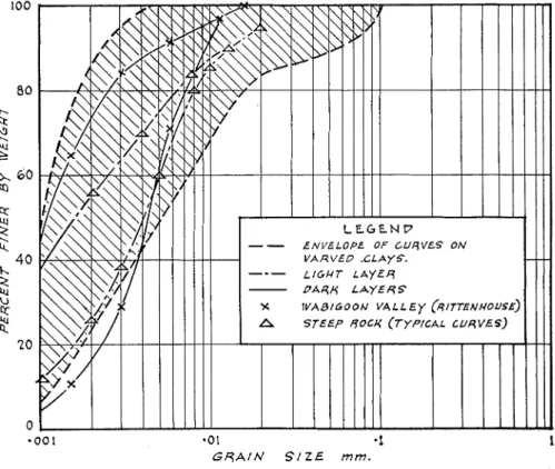
Results are generally plotted on special senlilogarithinic forms similar to that used for Figure 13. O n this diagram has been plotted the envelope of all the mechanical analyses of Steep Rock varved soils carried out by the senior author and by members of his staff. Equally of note is the relatively high percentage of soil particles in the Steep Rock varved soils which are below 0.002 mm. in equivalent diameter.
-00 1 a 0 1 -1 1
G R A I N S I Z E mm.
FIG. 13. Envelope of mechanical allalysis curves for aH clay samples. T h e first mechanical analyses to be made (by R. F. L.) on material from individual varves were somewhat roughly carried out a n d suggested that there was little significant difference between the particle-size distribution in the dark and light bands. Subsequent tests, more carefully carried out, notably
by H. B. Sutherland and W. J. Eden, have showed a definite and consistent
difference, although still witl~in the confiiles of the envelope sl~own in Figure
13. Typical curves have been plotted on the chart for dark and light bands and, for comparison, similar typical curves obtained by G. Rittenhouse in the only comparable investigation known to the authors.
Rittenhouse studied a n unusual series of varved clays that he found in the Wabigoon Valley, in the district of Kenora, Western Ontario, not more than
532 ROBERT 1;. LEGGET A N D M . W . B A R T L E Y
80 miles from Steep Rock Lalte. The reported abnormality included a dark
red color for a series of thick dark varves, which appears to be very similar to the same feature that is so common in the lowest of the Steep Rock de- posits. Rittenhouse reports mechanical analyses carried out by the pipette
method; two of these have been plotted (9).
FIG. 14. Variation of moisture content within varves.
I n a private report, H. B. Sutherland has summarized his filldings regarcl-
ing mechanical analysis of the varved materials by recorcling that, for the
samples he analysed, 50 percent by weight of all the dark laminae tested was
slnaller than 0.002 mm. in equivalent diameter, whereas only 10 percent of the particles from the lighter varves were of the same order of magnitude. Varia- tions in particle-size distribution within the varves have also now been studied. It is yet too early to report upon these variations in detail but it can be re- corded that, in the samples so far studied, there does not appear to be any
GLACIAL DEPOSITS AT S T E E P ROCK LAICE, ONT. 533
general gradation, uniform or otherwise, from top to bottom of the varve. Only in the case of the coarse red silty and sandy material, found close t o the rock, has any such gradation been detected, and even in this case, the grada- tion is not well defined and might even be explained by errors in sampling. The application of the refined methods of sampling and analysis may yet demonstrate that gradation does occur within laminae; variations in natural moisture content have already been detected.
Figure 14 shows some preliminary results from a detailed study of the natural moisture contents of light and darlt laminae, carried out by W. J.
Eden. As in the other tests reported, there is a marlted difference in moisture content in adjacent laminae. Correlation of these differences with differences
L l q U f P L I M I T
FIG. 15. Chart of liquid liiiiit a ~ i d plastic limit relationship.
in particle-size distribution appears to preselit a promising line of further in- quiry. Difficulties in sampling and testing the necessarily small quantities of soil involved have impeded progress, but the work is continuing.
The plasticity of the samples tested calls for comment. It has been found that the plasticity of fine-grained soils is related to their clay content, i.e., not just to the clay-sized particles but to the actual properties of the clay minerals contained in the soil. T h e property of plasticity is thus a useful indicator of soil type and it is so used in the engineering study of soil. Graphical meth- ods are again in common use as a useful means of presenting plasticity data. Figure 15 shows the, relation between the plasticity index and liquid limit for some of the Steep Rock samples. A difference between the plasticity of the material in light and darlt laminae will he at once apparent. That from
G L A C I A L D E P O S I T S A T S T E E P ROCK LAICE. O N T . 535
difference between the characteristics of the light and dark varvecl material ( 3 ) . Further investigations are in progress and it is hoped to study the mineralogical character of the soils in some detail.
SOME COMMENTS.
S o much factual information has been presented in sulilinary form in the foregoing pages that some general comments may usefully be presented in conclusion. Inevitably, these comn~ents raise some questions since they re- late to the complex phenomenon of the deposition of varved material.
T h e authors are familiar with the well publicized theory of annual depo- sition of D e Geer and have studied the relevant literature. Since an extensive bibliograpl~y accompanies Antevs' recent paper ( I ) , to whicli this paper is, in a sense, a companion, it does not appear t o be necessary to repeat any such extended list of references.
Apart fro111 the paper by Rittenhouse, ancl one by Fraser ( 7 ) , l~o\vever. the literature does not appear to contain any record of an approach to the prob- lein of varve deposition by way of such laboratory soil tests as have been here described. It map therefore be useful to point out how the results of these tests lead to some coilclusions siillilar t o those derived from geological rea- soning and to invite attentioil to some further questions that the test results suggest.
( 1 ) T h e natural moisture content of the varved material calls first for comment, not only because of the lack of any tendency for it to decrease with depth (for mixed samples), and the almost constant value for the water- plasticity ratio \\lit11 increasing depth, but also because of the variation he- tween the water naturally retained in the light and dark laininae respectively.
(2) Tlie variation of the natural n~oisture content of the varved material is partially explained by the variation hetween tlie plastic properties of the light ailcl tlarlc varved material. T h e essential differences hetween the two types of material are shown clearly in Figures 15 and 16. I t is generally as- sumed that the more plastic is a clay-sized soil. the more the contained particles consist of the clay minerals. I t can not be clo~~btecl but that this finely divided material is the product oi glacial action, at least in part, originating as rock flour, which would be expected to display very low plasticity. W h a t is not clear is ho\v such a marlcecl increase in plasticity, a s is shown het~veen light and dark varves, ancl therefore in mineral transformation, could take place in annual periods or, alternatively, coulcl vary so regularly at semi-annual in- tervals. T h e difference so strikingly shown in Figure 1 5 can only be ex- plained n~ineralogically, or by base exchange. I t is not clear Iiow such a sig- nificant change in the basic character of soil solids can be related merely to seasonal deposition.
( 3 ) I t may he pointed out that the light banded material is more coarsely grained and that this will explain the difference in plasticity, but the difference in particle-size, althougl? definite, is still slight. I n this same connection, it has already been noted that a relatively simple sedimentation test is used, in
536 ROBERT F. LEGGET A N D M . W . B A R T L E Y .
soil mechanics, for particle-size determination. By means of the theory of this test it is possible to calculate the time required for soil particles such as those at Steep Rock to settle in still water. Particles, for example, having an
ecluivalent diameter of 0.001 mm. ill water at a temperature of 35" F will settle
in 180 days only 28 feet. And not only does more than half the material in the dark varves consist of particles of this size or smaller, hut the estimated depth of the glacial lake was over 300 feet.
I n some discussions of varved depostion, circulation of lake waters due to
thermal gradients is suggested. If there is circulation of any Itind, there must
be some other factor affecting deposition because the carrying power of mov- ing water would effectively offset even the slow settling of the fine particles, since the velocity could not have been vertically downward at the lake bottom. There appears to be no gradation in particle-size throughout the section of a lamina. I f , however, the soil material in a varve is dried, ground up, soaked in distilled water and subjected to the usual sedimentation test for particle
size, it will gradually settle out with perfect gradation-from the coarser par-
ticles at the bottom to the very fine particles that remain in suspension. (4) I t is clear that some process in addition to ordinary sedimentation must have been operative when the varves were formed. Some indication of this is given by the consistently and "artificially" high natural moisture con- tent of the varve material, a characteristic alien to sediments deposited by straight settling. From the description given of the soil, it can be seen that it must have a "honeycomb" type of particle structure, in order for so large an excess of water to he present without being evident. This would seem to be possible only if there existed some kind of interparticle attraction during de- position. This, in turn. suggests the phenomenon of flocculation. I t is not without significance that, in conducting mechanical analyses of Steep Rock soil samples, it is almost always necessary to add hydrochloric acid to the 1.000 cc. suspension, even after it has stood for twenty hours, in order to pre- cipitate, as a flocculant, the very finest particles still remaininq in suspension. Correspondingly, more than the usual dispersing agent is required at the start of these mechanical analysis tests in order to break up the coil into its constit- uent particles.
( 5 ) Recent esperience at the Mine is related to this same feature in a practical way. Material fro111 the lake-bed at the "A" orebodv is now being pumped into the one section of the Lalte that remains at its oriqinal level (the west a r m ) . Through this large expanse of water, the Seine River now flows hut at negligible velocity because of the large cross-section of the water area.
Despite this, some material-pumped from its varved position-is picked up
by this very limited flow of water, carried to the foot of the Lalte and then down the old course of the Seine River for a distance of a t least 50 miles without settling out, passing through many smaller laltes on the way. Tests have shown, however, that most of the soil that is pumped fails to break un into its constituent particles even in passing through the pumps, but is deposited after discharge in particle-assemblages that correspond in size to chemically formed flocs.
GLACIAL DEPOSITS A T S T E E P ROCK L A K E , ONT. 537 (6) Flocculatioil involves electro-chemical action. Similar action must have been involved in the formations of the concretions that are found in the light layers of the Steep Rock soils. Also of significance, in this connection, is the blocky structure of the soil despite its laminated nature. The senior author has seen exactly the same type of structure developed in a clay slurry
that had beell subjected t o treatment by electro-osmosis. Sudden precipita-
tion of river sediments when sea water is encountered is a n associated phe- nomenon, even to the formation of concretions, as in the Fraser River estuary. I t has been noted that the Steep Rock varved material has, when wet, a bleach- ing effect upon colored clothing material, thus further substantiating the idea of sediment flocculation.
(7) Study of these facts suggested that possibly something could be gained
by reference to studies of other natural banded deposits. As is well known, discussion still continues regarding the exact origin of some of these. I t is of interest, however, to note that in an extensive study of the radiolarian
cherts of California (to which attention was kindly directed by Dr. H. H.
Aldrich), E. F. Davis cliscarcls the idea of a rl~ythmical annual cleposition
(6). Opinion seems to favor either the idea of regular deposition from supersaturated suspension or the concept of rhythmic segregation of colloidal silica.
(8) The authors are an-are that the concepts of flocculation, and of super- saturation, have been associated with the generally accepted theory of varve deposition. One of the clearest expositions which they have encountered in
their studies is in a very short paper 1117 E. M. Burwash ( 4 ) . I t is in a vol-
ume of a series not usually considered in relation to geological literature a n d so is reprinted, by perinission, as an Appendix. The idea of climate is promi-
nent, as usual, it1 this explanation, and it is this feature that the writers find
difficult to correlate with their fielcl observations. In addition to features
already mentioned, they have seen an exposure of ahout 30 feet in depth in
which the varves were all of identical tl~icltness. H a s climate changed, through the years, to the extent that such perfect regularity is just a thing of the past?
(9) Many details of the Steep Rock varved exposures raise other ques- tions, although not usually of so general a character as those already noted. One of these should, however, be inentioi~ecl, this being the repeated exposure
of very thin lan~inations all of a uniforinly light grey color with no evidence a t
all of inter-bedding by darker material. Uniortunately, it has not yet been possible to illake detailed studies of samples from these locatioils I ~ u t their existence raises further doubts as to the cliillatic variations of the past being
such as to eliminate entirely a loi~g series of winters.
(10) Finally, possibly the inost striltiilg of all the observed features of the varving in the fielcl are the reillarkable distortions in the varving regularly to be observed. T h e first that the writers observed were near the surface of the lake-hed deposits and included alillost complete "folds" of groups of varves. The action of surface ice seemed to be the only possible explanation of this phenomenal distortion. Later, far from the shore line, and well below
538 R O B E R T F. LEGGET A N D M . TV. B A R T L E Y .
vaguely possible explanation of these seemed to be the sliding in froin the sides of inaterial of the same age when the varves in cluestion were at lalte- bottom level. More recently, however, deep-seated distortions have been ex- posed, far removed froni any shore line, far below the recent lalte-bed level,
and amid large areas of quite level varves. Figure 17 is a typical esposure.
FIG. 17. Deformation in varves.
CONCLUSION.
The foregoing coinments indicate clearly the stimulus which the study of the Steep Rock soils has given to the thinking of the authors and all others who have worked with them in this investigation. I n all these studies, not only have they had the benefit of discussion with the Mine officers, notably those previously mentioned, but also the active co-operation of Ben Eyton, Chief Chemist of Steep Rock Iron Mine Limited, and, through the Division
of Building Research, National Research Council of Canada, of W. H. Ward
of the British Building Research Station, H. B. Sutherland now of the Uni-
versity of Glasgoxv (who spent the suminer of 1918 at the Mine), and F. L.
Peckover and W. J. Eden of the Division's Foundations and Soil Mechanics
Section, other lueinbers of which have contributed much in discussion and in test work. Laboratory studies of the varved soils continue at each of the
G L A C I A L D E P O S I T S A T S T E E P ROCIC LAICE, O N T . 5 3 9 institutions mentioned a n d i t is hoped t h a t illore detailed accounts of s o m e of t h e features mentioned generally i n this p a p e r m a y soon b e available.
BIBLIOGRAPEIY
( A very coinplete bibliography will be found at the end of the paper by Dr. Antevs listed below. Tlie followiilg list contains only the refereilces cited in this paper.)
1. Antevs, E r n s t , 1951, Glacial clays in Steep Roclc Lalce, Ontario, Canada: Geol. Soc. Am. Bull., vol. 62, no. 10, p. 1223-1262.
2. 1950, Procedures for Testing Soils; ilomeilclature and definitions, standard methods, sug- gested methods : Ainerican Society f o r Testing Materials, Philadelphia, 418.
3. Boswell, P . G. ]-I., 1949, Thixotropic and allied phenomena in geological deposits : Liverpool Geol. Soc. Proc., vol. 20, p. 2, p. 86-105.
4. Burwash, E. IvI., 1938, Deposition and alteration of varved clays: Trans. Royal Can. Inst., vol. 22, no. 47, pt. 1, p. 3-6, Toronto.
5. Casagrande, A,, and Fadnm, R. E., 1944, Application of soil iilechailics in designing building foundatioiis: Trans. Am. Soc. Civil Eng. Proc., vol. 70, no. 3, 11. 341-369.
6. Davis, E. F., 1918, T h e radiolarian chests of t h e Frailciscall Group : University of California Pubs. in Geology, vol. 11, no. 3, p. 235-432.
7. Fraser, H . J., 1929, An experiinei~tal study of varve deposition: Trans. Royal Soc. of Canada, vol. 23, sect. 4, p. 49-60.
8. Newland, D. I<., 1916, Landslides in unconsolidated s e d i i l ~ e i ~ t s ; with a description of some occurrences in the H u d s o i ~ Valley: N. Y. State Illuseuin Bulletin, no. 187, p. 79-105. 9. Rittenhouse, Gordon, 1934, A laboratory study of an unusual series of varved clays froin
northern Oiltario: An?. Jour. of Science, vol. 28, p. 110-120.
10. Roberts, H u g h M., and Bartley, hl. W., 1943, Replacement hematite deposits, Steep Rock Lalce, Ontario: Am. Inst. Min. & IlIetall. Engineers, Tech. Pub. no. 1543 f o r meeting February, 1942, 26 p. and (discussioil) no. 1632, 1913, 15 p.
11. Samuel, W., 1945, Steep Rock Iron Mines; discovery and development: Enginecriilg Jour- nal, vol. 28, no. 1, p. 4-9.
12. Terzaghi, K., 1950, Mecha,nism of landslides : reprinted from Engineering Geology (Berlcey Volunle), Geol.. Soc. of Am., p. 83-123.
APPENDIX.
A n explanation of varve formation by E. M. Burwash from his paper "The De- position a n d Alteration of Varved Clays," Trans. Royal Can. Institute, vol. X X I I , p. 3-6, Toronto, 1938.
A s water cools, its capacity for the solution of gases increases. The water of a frozen lake therefore is more highly acidulated by absorption of carbon dioxide than the wariner water of t h e summer which a t present ordinarily rises to a tem- perature of nearly 60' F. T h e solution of calcium carbonate in the water depends on that acidulation, a n d its deposition from the water probably on a decrease in
the acidulation, which would be brought about by a warming of the water. O n this basis we can perhaps correlate the deposition of the varves with the seasonal changes which must have been taking place a t the time of the sedimentation.
( a ) During the winter, the surface of the soil is frozen a n d precipitation re- mains upon it in the form of snow. Any slight liquefactio~l of the snow is frozen before it has time to run off in the form of drainage. I t cannot penetrate the froze11 upper layer of the soil. Underneath the frost layer, the unfrozen ground water continues to worlc its way slowly into the streams and lakes, carrying with it no solid sediment, but a considerable supply of dissolved salts, especially calcite. T h e
540 R O B E R T I;. LEGGET A N D A t . W . B A R T L E Y .
cold acidulated water of the lalte is well adapted to receive these, and retain them without precipitation, so that a condition of saturation is approached, perhaps nearly reached.
( b ) With the arrival of spring the ice-cover of the lake melts more slowly than the snow on the adiacent land. T h e floods that follow the liauefaction of t h e snow and the thawing of the surface soil carry large amounts of sblid sediment into the lake. T h e coarser parts are deposited near the shores, while the finer clay is car- ried further out and settles gradually over the bottom of the lake for g r e a t dis- tances, covering the bottom of even large lakes. The floods once over, the streams become clear, much reduced in volun~e, and the amount of silt carried out is negli- gible.
( c ) A s the lake waters gradually warm by direct solar radiation and conduction froin the air after the disappearance of the ice, and a r e further warmed by the inflow of warm surface waters, the capacity of the water t o retain carbon-dioxide is decreased, and the deposition of part of the solids dependent on its presence would follow. This includes all carbonates but mainly calcite. T h e actual con- dition is that the water in the depths of the lake remains colder all summer than that on the suriace. A s is well Itnown, t h e species of fish that prefer cold water a r e then found a t a considerable distance below the surface. The calcite released from solution in the warmer water near the surface ~ v o u l d sink until it came to the colder and Inore acidulated depths which would redissolve it, become saturated, and finally deposit calcite as a precipitate a t the bottom. W e may therefore refer the forination of the white partings in t h e clay to the summer season. T h e pre- tlominantly argillaceous layers must also be conceded t o contain some calcite, apart from the presence of numerous calcareous concretions in them.