https://doi.org/10.4224/20386268
Vous avez des questions? Nous pouvons vous aider. Pour communiquer directement avec un auteur, consultez la
première page de la revue dans laquelle son article a été publié afin de trouver ses coordonnées. Si vous n’arrivez pas à les repérer, communiquez avec nous à PublicationsArchive-ArchivesPublications@nrc-cnrc.gc.ca.
Questions? Contact the NRC Publications Archive team at
PublicationsArchive-ArchivesPublications@nrc-cnrc.gc.ca. If you wish to email the authors directly, please see the first page of the publication for their contact information.
https://publications-cnrc.canada.ca/fra/droits
L’accès à ce site Web et l’utilisation de son contenu sont assujettis aux conditions présentées dans le site LISEZ CES CONDITIONS ATTENTIVEMENT AVANT D’UTILISER CE SITE WEB.
READ THESE TERMS AND CONDITIONS CAREFULLY BEFORE USING THIS WEBSITE.
https://nrc-publications.canada.ca/eng/copyright
NRC Publications Archive Record / Notice des Archives des publications du CNRC :
https://nrc-publications.canada.ca/eng/view/object/?id=931b24c9-d20c-4417-90bc-4593b9f4681b
https://publications-cnrc.canada.ca/fra/voir/objet/?id=931b24c9-d20c-4417-90bc-4593b9f4681b
NRC Publications Archive
Archives des publications du CNRC
For the publisher’s version, please access the DOI link below./ Pour consulter la version de l’éditeur, utilisez le lien DOI ci-dessous.
Access and use of this website and the material on it are subject to the Terms and Conditions set forth at
Guide to a field description of permafrost for engineering purposes
http://irc.nrc-cnrc.gc.ca
Guide t o a Fie ld De sc ript ion of
Pe r m a frost for Engine e ring Pur pose s
P i h l a i n e n ,
J . A .
N R C C - 7 5 7 6
A version of this document is published in / Une version de ce
document se trouve dans: Supplement to the Building Code for
the North,1968, Section 4, pp. 49-65
GUIDE
FIELD DESCRIPTION
PERMAFROST
for
Almost one half of Canada's total land surface is underlain by permafrost and its existence has many implications to both scientific and engineering interests. Engineering experience has indicated that site investigations are essential in permafrost areas but no standard method for reporting permafrost conditions has been used or is available. This book- let has been prepared with the hope that the descrip- tive system outlined will fulfil this need.
The method for describing the ice phase in perennially frozen materials, which forms a major part of this "Guide", was originally developed by the Arctic Construction and Frost Effects Laboratory (now Cold Regions Research and Engireering Labora- tories) of the U.S. Corps of Engineers, with assistance from the Divlsion of Building Research, National Re- search Council, Canada. It is intended that the book- lets on Soils (Technical Memorandum 37) and Muskeg (Technical Memorandum 44) previously published by the Associate Committee on Soil and Snow Mechanics be used as companions to this Guide.
Comments and criticism regarding the usefulness of this suggested descriptive system for permafrost are encouraged and will be welcomed.
Section 4
TABLE
OF
CONTENTSPage
WHAT IS MEANT BY "PERMAFROST"
. . .
53BASIS OF THE DESCRIPTIVE SYSTEM . . . 53
. . . SURFACE CHARACTERISTICS 54 . . . Vegetation Cover 54 Snowcover . . . 54 . . . Relief and Drainage 54 SUBSURFACE CHARACTERISTICS . . . 55
Depth of Thaw . . . 55
Subsurface Materials . . . 56
(1) Soil Phase . . . 56
(2) Ice Phase . . . 57
(A) Ice Not Visible . . . 57
(B) Visible Ice
<
1 inch Thick . . . 58. . . (C) Visible Ice
> 1
inch Thick 58 FIELD INVESTIGATIONS AND RECORDS . . . . 59TABLE I-ICE PHASE DESCRIPTIVE SYSTEM 60 TABLE II--TERMINOLOGY
. . .
63 APPENDIX A-TYPICAL DATA SHEETS...
i
64I.
WRAT
IS MEANT BY "PERMAFROST""
Permafrost is defined
as
the thermal condition under which earth materials exist at a temperature below32OF
continuously for a number of years. Thw, all earth materials including bedrock, gravel, nand, silt, at or mixtures of these materials may exist in t c perennially below32°F
condition. Permafrost is defined exclusively on the basis of temperature, irrespective of texture, degree of in- duration, water content or lithologic character.The term "perennially frozen", although cumber- some, is generally used to describe specific peren- nially frozen materials, e.g. perennially frozen silt, perennially frozen organic material. The presence of ice is not a necessary requisite of permafrost, but when ice is present it is of particular significance to engineere.
The term permafrost can
also
be used to describe the areal extent of the below32°F
condition. It has been found convenient to divide the permafrost region into two major zones-the continuous and the discontinuous.In
the continuous zone permafrost is found everywhere under the ground surface toconsiderable
depth; in the discontinuous zone permafrost is not as thick and exists in combination with azeae of unfrozen material.2.
BASIS
OF THE
DESCRIPTIVE SYSTEM
Although permafrost is defined on a temperature basis, temperature is not a convenient or easily measured property for field description purposes. A more convenient approach to the field description of rmafrost is to describe terrain features that may i z e n c e the existence of permafrost. Observations of terrain and the effects of construction on perma- frost in northern Canada have suggested the follow- ing specific features of terrain that are of interest to engineers:
(1) Surface characteristics Vegetation cover Snow cover Relief and drainage
Section 4 (2) Subsurface characteristics Depth of thaw Subsurface materials Soil phase Ice phase
Observations on these topics represent a minimum of field information that must be collected to describe permafrost adequately for an engineering appraisal ot a site.
3.
SURFACE CMRACTERXSTICS
3.1 Vegetation Cover
The vegetative mantle of trees, shrubs, moss, lichen and other plants that covers much of the North acts as an insulator that protects and maintains permafrost. Vegetative cover is of additional interest in that it may indicate soil, ground water, wind and/or snow conditions. The major combinations of vegetation at a site should be delineated and de- scribed using the system outlined in the "Guide to a Field Description of Muskeg" (Technical Memo- randum 44) published by the Associate Committee on Soil and Snow Mechanics.
3.2 Snow Cover
Although snow is basically a part of the climate, snow cover is generally considered as a terrain factor. The presence of snow reduces the depth of seasonal frost penetration during the winter and conversely inhibits thawing of frozen material in the spring. The type of snow, the depth of snow cover and their variability over a site throughout the winter season should therefore be observed.
3.3 Refief a n d Drainage
Terrain relief influences permafrost occurrence and since it is also a significant factor i n drainage it is an important engineering consideration. Regional relief features should be described in addition to those observed at specific locations under investiga- tion. Regional descriptions should include some in- dication of altitudes; whether the landscape is mountainous, hilly, undulating or flat; possible
origin of the lan&orra; and the regional drainage pattern. Af specific sites small scale or micro features of relied and drainage should be noted. These small scale features axe difficult to classify for descriptive purposes but would include details of patterned ground (sorted or unsorted circles, nets, polygons, steps and stripes), micro-drainage, slope and expo- sure to solar raClialion.
W photographic record sf the various surface characteristics (e.g. showing t s i c a l vegetation and snow cover, and relief and drainage features) is most valuable, A complete description of site condi- tions can be usefully summarized on a sketch map on. air photograph of the area under investigation.
4. SUBSURFACE GHARACFEWHSFICI
4.1 D e p t h sf T h a w
The seasonal depth of thaw and its variability within an area and from year to year has long been recognized as an important engineering considera- tion in permafros"rreas. The depth of thaw refers to that portion below the ground surface at a specific location that is thawed at some time during the course of a summer.
lt
increases progressively during the thawtng season and therefore if is important to note the dale on which a particular observation was made. When the seasonal thaw has reached its maximum depth (usually in the late fall) it then cor- responds to the "'active layer". The "active layer" refers lo the zone in which seasonal thawing and freezing occurs.The depth and rate of thaw are affected by and closely related to terrain features. Any variations in an area are usually the result of differences in surface conditions such as vegetation, relief, drainage and snow cover and may also be related to changes in subsurface materials.
Initially, depth of thaw observations should be made in areas having different surface covers and then extended to locations within these areas that have noticeable changes in relief, drainage or sub- surface materials. Appreciable differences in the
depth of thaw for an area as small as 5 feet square are possible. It is important therefore to make many random observations at a site and to record not only the average but also the maximum and minimum depths of thaw for the area.
The depth of thaw can be conveniently measured using a probe that retains a sample of the thawed subsurface materials for examination. Records of the depth of thaw should also include notes on the date of observation, vegetation cover, relief, drainage, and a description of the subsurface materials in the various areas probed. Some assessment of the mois- ture content, density and ice segregation in the frozen soil underlying the thawed zone are of particular interest.
4.2 Subsurface Materials
The materials encountered in the frozen state vary, and can include bedrock, gravel, sand, silt, clay and organic material (peat). These frozen materials or combinations of them frequently contain consider- able quantities of ice. Important engineering impli- cations are involved when this condition occurs. It is important, therefore, to examine not only the soil but also the ice encountered in the mil. For engineer- ing purposes, it is convenient to describe the soil and ice phases independently. At times a description of frozen bedrock may be required. It will be noted in the following paragraphs that the ice description system is based on the form of ice in frozen materials and is therefore applicable for either mils or bedrock. 4.2.1 Soil phase
The description of the soil phase applies to mate- rials found in both the thawed and frozen states. Coarse- and fine-grained soils should be described according to the "Guide to a Field Description of Soils" (Technical Memorandum 37) published by the Associate Committee on
Soil
and Snow Mechanics. Partly organic soils, which are largely mineral types, are described as the predominant soil modified by the word "organic", e.g, organic silt. Soils that are mostly organic (peat), however, should be de- scribed according to the system outlined in "GuideSection 4
to a Field Description of Muskeg" (Technical Memo- randum 44).
4.2.2 I c e p h a s e
The descriptive system for the ice phase is based on the f o r m of ice found in frozen materials.
It
is not intended that this system be used to assess frozen materials according to properties or performance. For descriptive purposes frozen materials are divided into three major groups in which the ice is:n o t visible by eye,
visible by eye with individual ice layers less than 1 inch in thickness,
visible by eye with individual ice layers greater than 1 inch in thickness.
The major ice phase descriptive groups and their subdivisions are summarized in Table
I.
Letter symbols that suggest key descriptive terms of the ice forms for each subdivision have been included to help in the preparation of graphic logs or records. Written observations, however, are the fundamental feature of the descriptive system and the letter designations must be regarded only as a "short- hand" form. Guides for further descriptive details and illustrations of the basic types are included.It
is not expected or intended that all of the detail shown in TableI
should always be noted. In much engineer- ing work only the most fundamental details need be recorded. Some definitions to clarify terms used in the ice phase descriptive system are given in Table 11.(A) Ice n o t visible
When ice is not discernible by eye its effective- ness as a cementing agent in bonding the mineral or organic portion is used as a further subdivision:
(a) ice that bonds or cements the subsurface materials into a weak o r friable mass, (b) ice that bonds the aubsurface material into a
The presence of ice not generally di,seernible by eye mag be revealed within the voids of She material
by crystal refiecfion~ or by a. sheen on fractured or tsim,med surfaces. The innpression ta the unaided eye
i s that none of the frozen water occupies space in excess of the original. voids in the soil. The apposite
is true of soils where the ice segregation is visible by eye.
In some eases, parkicuiax!g in materials wei: bonded by lee, a large poriaan of rh? nate~aal map actually be lass even though rt is not dascernihle by eye. When msuai methods are anadequate, a sample
held Seer to and avaluaiaon of the volume of excess ice
can be made by ~ X B C P M ~ a chunk of bhe matersal an il small jar, allowing it lo thaw, and obsarvlng the
quant1t.y sf water as e percentage of the total volume,
I f b e e water IS aaQd ~t is termed "axce~s"~
( B ) Vis~hle ice segregation lass f h w ~ ~ 1 inch C1lic:JcrR
WLsr
ice is discasaibia by e y e and fa less than 1 inch thick further subdivision is based on the form and orientaEon of the ice conceutrago~la:(a) i n d i ~ d u a l ice crystab ax inclusions,
(b)
ice eoaEngs on padbcles,(c) random or irregular-slpr o~eeated ice formaeiowa, (d) etaatified or distinctly oxiewlad ice iarmafions,
(C)
T3isib1e ice segregation greater khan i 9ncPthick
For descfipbve purpo8~~1, ice foamafions greater khan 1 inch thick may be considered as ICE, Twrs types of ice strata are recognized at present:
(a) ice with soil inclusions,
(b) ice without soil inclusions.
%a some cases the occurrence of stratified or distinctiy oriented ice formations in frozen soil in- creases to such an extent that the frozen material. approaches "ice with silt lenses'" Although the absence or inclusion of soil in ice is a first subdivision, the ouer-all form of the ice mass should also be
random or irregularly oriented layers, vertical, wedge-shaped sheets, and variable chunks or blocks sometimes hundreds of square feet in area.
3. FEELD PNVESTIgiAT%Q)NS
AID
RECORDS
The scope of field investigations of permafrost and the amount and type of information required will depend largely upon the use lor which it is intended.
A discontinuity in the occurrence of permafrosi
(areas free of permafrost or large variations in the depth to permafrost) has many implications to con- struction. Accordingly, a sufficient number of ob- servations must be made at a site so that the areal occurrence of permdrost is adequately delineated. This is particularly impoakant in the discontinuous zone where permafrost occurs in scattered patches or "islands" in combination with areas of thawed ground.
All inlomefion collected should be recorded an data sheets. Typical ~ h e e t s of recorded information have been included. Most of the specific details required are noted; other pergnent information may be added,
TABLE
1
ICE DESCRETIONS
A.
ICE
NOT VISIBLE(s) Subgroup1
Group1
Symbol Description
1
Symbol Field Identification(a) Frosen soils in the
N
group may, o n close examination, indicate presence o f ice withinthe voids o f the material by crystalline reflections or by a sheen on fractured or trimmed surfaces. The impression received by t h e unaided eye, however, is that none o f the frozen water occupies space in excess o f the original voids in the soil. The opposite is true o f frozen soils in the V group (see p. 14).
Poorly bonded or friable
N o excees ice Well-bonded
Excess ice
(b) W h e n visual methods m a y be inadequate, a simple field test t o aid evaluation o f volume
o f excess ice can be made by placing some frozen soil in a small jar, allowing i t to m e l t , and observing t h e quantity o f supernatant water as a percentage o f total volume.
FIG
A ,ICE
NOT VISIBLENf
-,-j Nbn Nb I--- j NbeN
f NbnNbe
POORLY BONDED WELL BONDED
-
WELL BONDED- NO EXCESS ICE EXCESS ICELEGEND: SOIL
-a
-
ICE-
arIdentify by visual examination, To determine presence of excess ice, use procedure under notecb) and hand magnifying lens as necessary. For soils not fully saturated, estimate degree of
ice saturation: medium, low. Mote presence of
TABLE
I
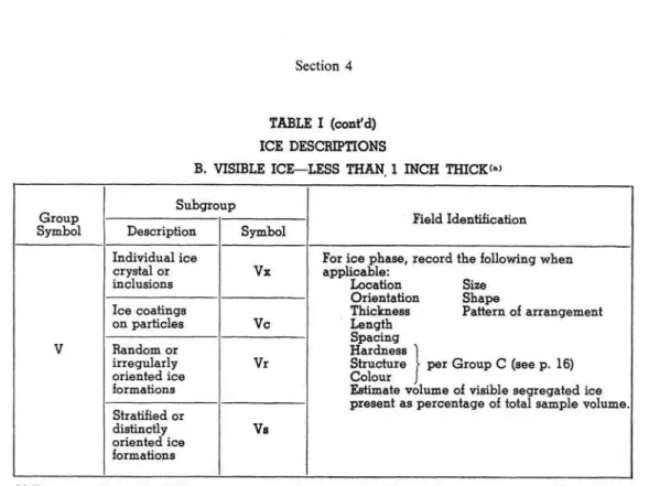
(cont'd) ICE DESCRIPTIONSB. VISIBLE ICE-LESS THAN, 1 INCH THICK(*)
Group Symbol Ice coatings on particles
I
Subgroup Description Individual ice crystal or inclusions Field IdentificationI
Symbol Vx Random or irregularly oriented ice formations Stratified or distinctly oriented ice formationsFor ice phase, record the following when applicable:
Location Size Orientation Shape
Thickness Pattern of arrangement Length
Spacing Hardness
Structure par Group C (see p. 16)
Colour
1
Estimate volume of visible segregated ice present as percentage of total sample volume Vr
Vs
("1 Frozen soils i n t h e N g r o u p m a y , o n close examination, indicate presence of ice w i t h i n
t h e voids of t h e m a t e r i a l by crysfalline reflections o r by a sheen o n f r a c t u r e d o r t r i m m e d surfaces. The impression received by t h e unaided eye, however, is t h a t n o n e of t h e frozen water occupies space i n excess of t h e original voids i n t h e soil. The opposite is t r u e s f frozen soils i n t h e V group.
F I G B. V : S I B L E LCE LESS THAN ONE INCH THICK
INDIVIDUAL I C E I C E COATINGS RANDOM OR S T R A T I F I E D OR
INCLUSIONS ON PARTICLES IRREGULARLY D I S T I N C T L Y
ORIENTED ICE ORIENTED ICE
FO RMATl ON S FORMATIONS
TABLE
I
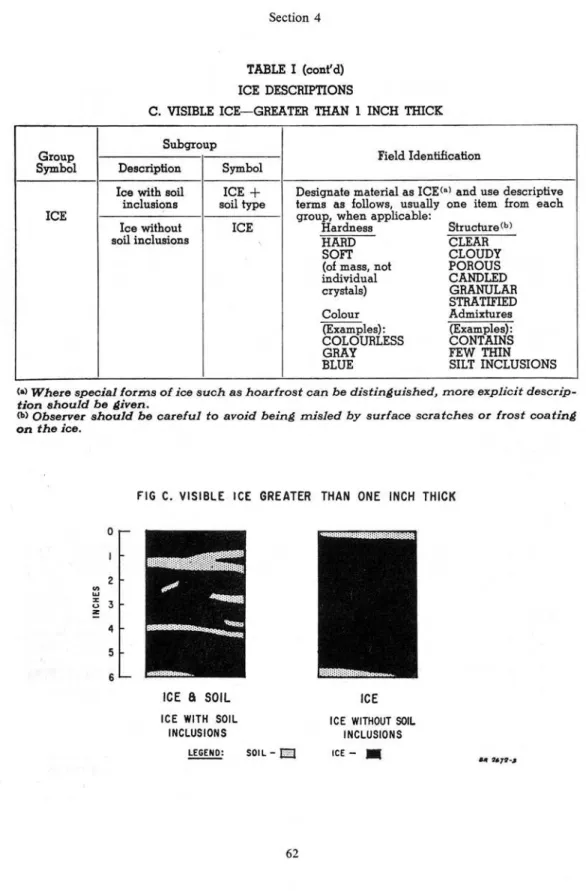
(cont'd) ICE DESCRIPTIONSC . VISIBLE ICE-GREATER THAN 1 INCH WICK
Group Symbol
Subgroup
Description
1
Symbol Field IdentificationICE
Ice without ICE
soil inclusions
Designate material as ICE(%) and use descriptive terms as follows, usually one item from each group, when applicable:
Hardness Structurecb)
HARD CLEAR
SOFT CLOUDY
(of mass, not POROUS
individual CANBLED crystals) GRAWLAR S'FBATIPIED Colour . - - Admixtures (Examples): (Examples): COLOURLESS CONTAINS
GRAY FEW THIN
BLUE SILT INCLUSIONS
( 8 ) Where special forms o f ice such as hoarfrost can be distinguished, more explicit descrip-
tion should be given.
(b) Observer should be careful t o avoid being misled by surface scrafches or frost coating on the ice.
FIG
C.
VlSlBhE I C E GREATER THAN ONE: INCH THICKICE FA SOIL ICE
I C E WITH SOIL I C E WITHOUT SOIL
INCLUSIONS INCLUSIONS
" k L E %I
TERMINOLOGY
Ice Coatings o n Particles are discernible layers of ice found on or below the larger soil particles in a frozen soil mass. They are sometimes associated with hoarfrost crystals, which have grown into voids produced by the f~eezing action.
Ice Crystal is a very small individual ice particle visible in the face of a soil mass. Crystals may be present alone or in combination with other ice dormations.
Clear Ice is transparent and contains only a moderate number of air bubbles.
Cloudy Ice is relatively opaque due to entrained air bubbles or other reasons, but which is essentially sound and non-pervious.
Porous Ice contains numerous voids, usually inlerconneeted and usually resulting from melting al air bubbles or along crystal interfaces from presence of salt or other materials in the water, or from the freezing of saturated snow. Though porous, the mass retains its structural unity.
CandledIce is ice that has rotted or otherwise formed into long columnar crystals, very loosely bonded together.
G r a n u l a r Ice is composed of coarse, more or less equidimensional, ice crystals weakly bonded iogether.
Ice Lenses are lenticular ice formations in soil occurring essentially paralhl to each other, geuexally sormal to the direction of heat loss and commonly in repeated layers,
Ice Segregation is the growth of ice as &sfinct Ienses, layers, vehs, and masses in soils commonly but not always, oriented normal to direction of heat loss.
Well-bonded signifies that the soil particles are strongly held together by the ice and that the frozen soil possesses rela?ively high resistance fo chipping or breaking.
Poorly-bonded signifies that %he soil pariicles are weakly held together by the ice and that the frozen soil consequently has poor resistance Be chipping or breaking.
Friable denotes extremely weak bond between soil particles. Material is easily broken up.
Excess Ice signifies ice in excess of the fractjon that would be retained as water in the soil voids upon thawing.
Fox a more complete list of terms generally accepted and used in current literature on Frost and Permafrost see Rennion, F. "'FROST
AND
PERmPRBST BEFINITEONS"', Highway Research Board, Bulletin 111, 1955.UPEND=
ALE P O R M S POW
PERMAFROST
FIE- ktECORDS
I.
EXPLORATION & TEXRAIN NOTES1. LOCATION: Thunder River, N.W.T. HOLE No. T.P. 24 SITE: Centre Proposed Hostel-Site 4
DEPTH:
22'
AIR PHOTO: A 18635-49;
N
1.7,
W
4.3 ELEVATION: 28' above river water levelNA &
NR.
Plan-TR-A-1
(hand level)NOTES
BY:
John Smith DATE: START a.m. 14/8/56END
p.m. 17/8/56 2. METHOD OF EXPLORATION: Portable gasoline powered jackhammer.Pit Size-4' x 6'-3 local labourers.
REMARKS: No difficulties, log cribbing from
14-22'.
Rain all day 15/8/56
3. VEGETATION
COVER
SYMBOL-SITEFEI
KREA
IFDESCRIPTION: At Site-irregular distribution of grass hummocks and sedges with moss covering most of surface-odd low shrub. Area-predominantly moss covered with irregular distribution of grasses and sedges.
4.
RELIEF
REGION: Lowland, flat, recent alluvium.
SITE: 6' high grass tussocks, some mounds 4' in diameter and 1' high.
5. DRAINAGE: Poor-many puddles of scum covered water. During spring run off overflow probably runs to small creek 200' E. (which is now dry) and thence to river.
6. GENERAL
DEPTH OF THAW-HOLE-AVERAGE 20" Max. 26" Min. 10" DATE 16/8/56 AREA-AVERAGE 18" Max.
27"
Min. 10" DATE 16/8/56 REMARKS: Local inhabitants report wind packed snow drifts up toS'
deep cover site.Location-Thunder R.. N.W.T. BoringStart-14.8.56 Org. Terrain-F.E.I. Site-Hostel--Site # 4 End -1'1.8.56 Topography-Flat lowland Hole No.-T.P. 24 Notes b y 4 . S m i t h Elevation-28' above river level
II. PERMAFROST - SUBSURFACE FEATURES
Hole Depth, Soil Depth, Soil Description Cat. #8-light t o dark brown Peat--category # 1 3 - reddish brown t o dark brown- 1 branch a t 3.5 it.- 4 in. i n diameter Light brown silty fine sand Grey clay, high plasticity, random small
(W"
dia) rounded pebbles Gravel, poorly graded, mostly rounded stones %"- 2' i n diameter---
BOTTOM OF EXPLORATION::*
1
Log st. f t . Ice 1 . 6 4.6 6 . 8 8 . 5 10.8 14.3 17.7 19.0r-
Samples - -2-M/C 1-G.S. Description THAWED --.---.-Frozen-no visible ice seg., well bonded- material breaks i n slabs 12" long x 3" thick
---.-.---.---.
Hairline ice lenses, a b o u t 1" spacing i n Nbn H.L. hor. lenses
M"
t o %" spacing, visible . ice = 15% of t o t a l volume1" hor. ice lenses spaced a b o u t 8 in.- odd diagonal h.1. ice lens (2-3 in. long)
---..-...-..--.-.-..
gation, well bonded No visible ice segre- Ice with clay inc.- ice soft, cloudy, milky white; clay inc1.-angular, avge. l R long, X'' thick Ice soft, cloudy.
milky white Ice coating stones u p t o