HAL Id: insu-01575489
https://hal-insu.archives-ouvertes.fr/insu-01575489v2
Submitted on 8 Jun 2018HAL is a multi-disciplinary open access archive for the deposit and dissemination of sci-entific research documents, whether they are pub-lished or not. The documents may come from teaching and research institutions in France or abroad, or from public or private research centers.
L’archive ouverte pluridisciplinaire HAL, est destinée au dépôt et à la diffusion de documents scientifiques de niveau recherche, publiés ou non, émanant des établissements d’enseignement et de recherche français ou étrangers, des laboratoires publics ou privés.
above the tropical la reunion island using rayleigh-mie
doppler lidar
Sergey Khaykin, Alain Hauchecorne, Jean-Pierre Cammas, Nicolas
Marquestaut, Jean-François Mariscal, Françoise Posny, Guillaume Payen,
Jacques Porteneuve, Philippe Keckhut
To cite this version:
Sergey Khaykin, Alain Hauchecorne, Jean-Pierre Cammas, Nicolas Marquestaut, Jean-François Mariscal, et al.. Exploring fine-scale variability of stratospheric wind above the tropical la reunion island using rayleigh-mie doppler lidar. EPJ Web of Conferences, EDP Sciences, 2018, The 28th International Laser Radar Conference (ILRC 28), 176, pp.03004. �10.1051/epjconf/201817603004�. �insu-01575489v2�
EXPLORING FINE-SCALE VARIABILITY OF STRATOSPHERIC
WIND ABOVE THE TROPICAL LA REUNION ISLAND USING
RAYLEIGH-MIE DOPPLER LIDAR
S. M. Khaykin1*, A. Hauchecorne1, J.-P. Cammas2, N. Marqestaut2, J.-F. Mariscal1, F. Posny2, G. Payen2, J. Porteneuve1, P. Keckhut1,
1
LATMOS-IPSL, Université Versailles St.-Quenitn, CNRS/INSU, Guyancourt, France, *Email: [email protected]
2
OSUR, UMS3365, Université de la Réunion, Saint-Denis, La Réunion, France ABSTRACT
A unique Rayleigh-Mie Doppler lidar capable of wind measurements in the 5-50 km altitude range is operated routinely at La Reunion island (21° S, 55° E) since 2015. We evaluate instrument’s capacities in capturing fine structures in stratospheric wind profiles and their temporal and spatial variability through comparison with collocated radiosoundings and ECMWF analysis. Perturbations in the wind velocity are used to retrieve gravity wave frequency spectrum.
1. INTRODUCTION
Wind measurements above 30 km are rare. The only information available on a regular basis is zonal mean winds inferred from satellite-borne pressure measurements assuming geostrophic balance. However this does not allow understanding the propagation of gravity waves, whose filtering, dissipation and/or breaking strongly depend on wind speed and direction. Observations of high vertical resolution (~ 1 km) are required for detecting wind shears around the stratopause, which play a crucial role in reflecting or filtering of the waves. Following this requirement, a direct-detection Doppler lidar for wind observations in the middle atmosphere has been developed in France in 1989 [1]. After deployment of the Doppler lidar at Observatory of Haute Provence (OHP) in Southern France (44° N, 6° E, 600 m a.s.l.) in 1993 the technique was shown capable of wind measurements between 5 and 50 km independent of the presence of aerosols [2]. The wind lidar was operated on a regular basis during 1994-1999 and occasionally since then. The observations were used to construct wind climatology in the middle atmosphere and to study gravity wave spectra and small-scale wind fluctuations [3].
In 2012 the Rayleigh-Mie Doppler lidar was deployed at a newly established tropical observatory located on mount Maïdo (21° S, 55°
E, 2200 m a.s.l.) at La Reunion island [4]. The Doppler lidar at Maido was operated on a campaign basis since 2013 and routinely, twice a week since September 2015. The wind measurements above La Reunion island represent a substantial value for studying the dynamics of the tropical middle atmosphere – a region where observations are particularly sparse. They are also of big relevance for validation of the upcoming European Space Agency (ESA) ADM-Aeolus satellite mission for global observations of wind. ADM-Aeolus mission will carry a Rayleigh-Mie Doppler lidar, based on the same principle as the French ground-based lidars. 2. INSTRUMENT DESIGN
The horizontal wind components are obtained by measuring Doppler shift between emitted and backscattered light by means of a double-edge Fabry-Perot interferometer with two half-disks areas whose air gap is slightly different, providing two bandpasses. The Doppler shift is due to projection of molecules or particles velocities onto the line of sight of the laser inclined off zenith. The laser beam is sent alternatively to zonal and meridional direction for obtaining both wind components, whereas the vertical pointing is used for measuring the zero Doppler shift reference (in assumption that the vertical wind is negligible).
The Doppler lidar uses a Q-switched, injection-seeded Nd:YAG laser operating at 532 nm in monomode. The pulse repetition rate of the laser is 30 Hz with 24 W mean energy. The 0 . 3 m2 telescope o f Maido wind lidar is composed of a single rotating mirror, which serves for both the emission and reception.
To extend the altitude range of measurements, there are two pairs of gated photomultipliers (PMT) collecting ~90% (high-gain channels) and ~10% (low-(high-gain channels) of the signals. More detail on the instrument can be found in [5] and references therein.
© The Authors, published by EDP Sciences. This is an open access article distributed under the terms of the Creative Commons Attribution License 4.0 (http://creativecommons.org/licenses/by/4.0/).
4. RESULTS
The Doppler wind lidar at Maido observatory is operated routinely since September 2015. In addition to the regular observations, two dedicated measurement campaigns have been held at Maido in September-October 2015 (LIDEOLE-II) and June 2016 (ARISE2). During these campaigns the wind lidar measurements were validated using collocated radiosonde ascents (Modem PTU-wind M-10 GPS radiosondes) conducted simultaneously with lidar acquisitions. Most of the radiosondes at Maido were launched using Totex 3000 gr rubber balloons allowing the payload to reach 40 km altitude for ensuring the largest possible height overlap with the lidar vertical profiles.
4.1 Intercomparison of lidar, radiosondes and operational analysis
The Doppler lidar validation exercise included 9 collocated radiosonde ascents performed within the measurements campaigns since September 2015. Intercomparison of lidar and radiosonde wind profiles showed excellent agreement, with a mean deviation between 0.1 and 2.5 m/s over the 5 - 40 km altitude range and correlation coefficient between 0.85 and 0.99.
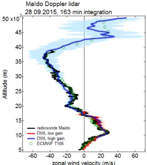
Fig. 1 shows an example of comparison of zonal wind profile up to 50 km obtained with lidar (~3 h integration time) and the radiosonde profile. The wind profiles retrieved using low- and high-gain channels of Doppler lidar are fully consistent with those reported by the radiosounding in the entire range of overlap. The maximum air distance between the radiosonde trajectory and lidar sampling area amounted to 45 km at 15 km altitude.
Lidar measurements in the upper stratosphere (above 40 km) were evaluated using ECMWF (European Center for Medium-Range Weather Forecast) T106L137 operational analysis. The model reproduces well the local maximum of easterly wind (-46 m/s) at 37 km seen by lidar and radiosonde and a strong wind shear above, where zonal wind changes to westerly within a ~5 km-thick layer, reaching ~30 m/s at 43 km. We note that in most cases the model tends to smoothen the vertical structures reported by the lidar, which is expectable and can be readily attributed to low vertical resolution of the model at upper stratospheric levels and the assumption on the geostrophic balance. At the
same time, the statistical uncertainty (two times standard error) of lidar measurement increases rapidly above 30 km and reaches ~20 m/s at 45 km altitude for a 3 hours acquisition, rendering the lidar retrieval less accurate in the upper stratosphere. This can be remedied by increasing the acquisition interval to more than 4-5 hours.
Figure 1. Comparison of zonal wind profiles obtained using Maido Doppler wind lidar on 28.09.2015 with collocated radiosounding and ECMWF operational analysis. Shaded areas indicate the total error of lidar retrieval.
4.2 Capturing fine vertical structures While the upper stratosphere sampling requires long acquisition time, the lower stratospheric wind profiles can be reliably acquired using sub-hourly integration intervals. Fig. 2 displays an example of lidar – radiosonde intercomparison at 15-23 km altitude range. The lidar wind profile was retrieved by integrating over 50 minutes interval corresponding to the radiosonde’s ascent through the stratosphere. The maximum air distance between the radiosonde ascent trajectory and lidar sampling area amounted to 32 km at 18 km altitude.
The lidar profile of zonal wind follows precisely the radiosonde profile, reproducing the vertical structures on a scale of a few hundred meters. The vertical structure of wind profile can be correlated with that of temperature profile taken by the radiosonde and plotted in Fig.2 as a red curve. The cold point tropopause can be found at 17 km altitude. One can see two sub-kilometer-thick layers above the tropopause centered at 17.8 km and 19.2 km altitude and
characterized by enhancement in easterly component of wind by about -10 m/s coinciding with local temperature minima. Similar patterns can be seen in meridional wind profiles (not shown). These coincident structures in wind and temperature are indicative of gravity waves manifesting themselves as perturbations in thermodynamical state of the stratosphere.
Figure 2. Fine vertical structures in zonal wind profiles (bottom axis) from Maido Doppler wind lidar (blue curve) and collocated radiosounding (black curve). Radiosonde temperature profile (top axis, red curve). The date and time interval of the lidar acquisition/ radiosonde measurement are indicated in the top of the panel.
4.3 Short-scale temporal variability
An important and unique capability of the Doppler lidar technique is the continuous time-resolved measurements of stratospheric wind profile over the course of the night. As opposed to radiosoundings, yielding a snapshot of the atmospheric state, the time-resolved lidar observations are capable of providing information on short-period wind fluctuations due to high-frequency gravity waves.
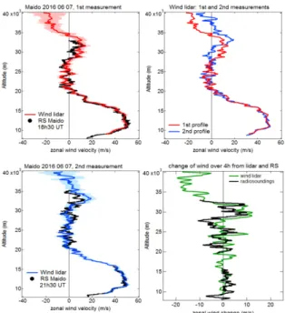
An experiment carried out within ARISE2 campaign at Maido in June 2016 was aimed at validating the wind temporal variability observed by the lidar using two radiosoundings launched with a 3-hour time interval. The left-hand panels in Fig. 3 shows comparison of radiosonde zonal wind profiles with the time-correspondent lidar measurements (1.5 h non-overlapping integration intervals) and suggest a good agreement for the both soundings. The top right panel compares the two consecutive lidar profiles, demonstrating a remarkable change of the wind profile above 27 km. The bottom right panel quantifies the wind
change observed by lidar and compares it with that inferred from two radiosonde ascents. One can see that evolution of the zonal wind profile observed by the lidar is fully confirmed by the radiosounding.
Figure 3. Verification of lidar
temporally-resolved wind measurements using two
radiosoundings: (top and bottom left) comparison of radiosonde and lidar wind profiles for the two consecutive soundings; (top right) comparison of two independent lidar profiles separated in time by 3 h; (bottom right) wind change over 3 h observed by lidar and radiosondes.
Importantly, in this experiment the radiosonde, carried towards the East by a strong westerly wind in the upper troposphere, was displaced by 100 km with respect to the lidar sampling area at 30 km altitude. This suggests that the temporal variability of wind in the tropical mid-stratosphere (up to 6 m/s per hour) is more important than the meso-scale spatial variability.
4.4 Gravity wave characteristics
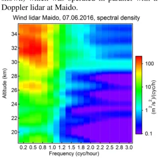
After having verified the temporal evolution of wind profile, the measurements on 7th June 2016 were used to derive the frequency spectrum of gravity waves. The continuous lidar measurements of zonal wind spanning 6.4 hours were binned to 10-minute time intervals, allowing to detect waves in the frequency range 0.16 < ω < 3 min-1. The frequency power spectrum was computed using Fourier transform for each 1-km layer.
Fig. 4 displays a power spectrum of stratospheric gravity wave frequency as a
function of height. Remarkable is the intensification of low-frequency waves (ω < 1 min-1) at 26 km and above, which is consistent with the inference regarding wind change made on the basis of Fig. 3. The higher frequency waves (ω > 2 min-1
) manifest themselves mainly above 29 km. The height distribution of gravity wave frequency spectrum obtained from wind measurement is found consistent with that derived from Rayleigh temperature lidar (not shown) which was operated in parallel with the Doppler lidar at Maido.
Figure 4. Power spectrum of stratospheric gravity wave frequency as a function of height derived from Maido wind lidar acquisition on 07.06.2016
6. SUMMARY
A Rayleigh-Mie Doppler lidar, capable of wind measurement up to 50 km altitude is operated at a tropical high-altitude Maido observatory since 2013. The results obtained within dedicated validation campaigns allowed evaluating instrument’s performance and its capability to capture fine structures in stratospheric wind profiles.
Intercomparison of wind lidars and GPS radiosondes lifted up to 40 km altitude shows excellent agreement. The lidar is shown capable of capturing wind profile structures on a scale of a few hundred meters. Wind lidar measurements in the upper stratosphere are consistent with ECMWF operational analysis, however some discrepancies in the vertical structures are noted.
Temporal and spatial variability of stratospheric wind is explored by combining lidar measurements and collocated radiosoundings. A significant change in wind
velocity profile at mid-stratospheric levels observed by lidar over the course of the night is fully confirmed by two successive radiosonde ascents conducted 3 hours apart during the lidar acquisition. We note that the temporal variability of wind in the tropical mid-stratosphere (up to 6 m/s per hour) is more important than the meso-scale spatial variability. This observation has important implications for the validation of ADM-Aeolus satellite mission.
Perturbations in the wind velocity are used to retrieve inertia-gravity wave frequency spectrum in the lower and middle stratosphere. An enhancement of wave activity is found above 26 km where the low-frequency waves (ω < 1 min-1) dominate the spectrum.
ACKWNOLEDGEMENTS
The work was supported by the French National Space Agency (CNES), CNRS-INSU, Université de La Réunion and by the EU H2020 ARISE2 project.
REFERENCES
[1] Chanin, M. L, A. Garnier, A. Hauchecorne, J. Porteneuve (1989): A Doppler lidar for measuring winds in the middle atmosphere,
Geophys. Res. Lett., 16(11), 1273–1276.
[2] Souprayen, C., A. Garnier, A. Hertzog, A. Hauchecorne, J. Porteneuve (1999): Rayleigh– Mie Doppler wind lidar for atmospheric measurements. I. Instrumental setup, validation, and first climatological results, Appl. Opt., 38, 12.
[3] Hertzog, A., C. Souprayen and A. Hertzog (2001): Measurements of gravity wave activity in the lower stratosphere by Doppler lidar, J. Geophys. Res., 106, D8, 7879-7890.
[4] Baray, J.-L., Courcoux, Y., Keckhut, P., Portafaix, T., Tulet, P., Cammas, J.-P., Hauchecorne, A. et al. (2013) Maïdo observatory: a new high-altitude station facility at Reunion Island (21° S, 55° E) for long-term atmospheric remote sensing and in situ measurements, Atmos.
Meas. Tech., 6, 2865- 2877, doi:10.5194/amt-6-2865-2013.
[5] Khaykin S., Hauchecorne A., Porteneuve J., Mariscal J.-F., D'Almeida E., Cammas J.-P., Payen G., Evan S., Keckhut P. (2016) Ground-based Rayleigh-Mie Doppler liar for wind measurements in the middle atmosphere, EPJ Web of Conferences, EDP Sciences, 2016, The 27th International Laser Radar Conference (ILRC 27), 110, pp.13005.