HAL Id: hal-03102007
https://hal.archives-ouvertes.fr/hal-03102007
Submitted on 11 Jan 2021
HAL is a multi-disciplinary open access
archive for the deposit and dissemination of
sci-entific research documents, whether they are
pub-lished or not. The documents may come from
teaching and research institutions in France or
abroad, or from public or private research centers.
L’archive ouverte pluridisciplinaire HAL, est
destinée au dépôt et à la diffusion de documents
scientifiques de niveau recherche, publiés ou non,
émanant des établissements d’enseignement et de
recherche français ou étrangers, des laboratoires
publics ou privés.
Relationships between δ 18 O in precipitation and
surface air temperature in the Urumqi River Basin, East
Tianshan Mountains, China
Yao Tandong, Valérie Masson, Jean Jouzel, Michel Stievenard, Sun Weizhen,
Jiao Keqin
To cite this version:
Yao Tandong, Valérie Masson, Jean Jouzel, Michel Stievenard, Sun Weizhen, et al.. Relationships
between δ 18 O in precipitation and surface air temperature in the Urumqi River Basin, East
Tian-shan Mountains, China. Geophysical Research Letters, American Geophysical Union, 1999, 26 (23),
pp.3473-3476. �10.1029/1999GL006061�. �hal-03102007�
temperature in the Urumqi River Basin, east Tianshan
Mountains, China
Yao Tandong
Lanzhou Institute of Glaciology and Geocryology, Chinese Academy of Sciences, Lanzhou, China
Va16rie Masson, Jean Jouzel, Michel Stievenard
Laboratoire des Sciences du Climat et de l'Environnement CEA-CNRS, Gif-sur-Yvette, France
Sun Weizhen and Jiao Keqin
Lanzhou Institute of Glaciology and Geocryology, Chinese Academy of Sciences, Lanzhou, China
Abstract. In order to evaluate the dependency of present-day
15•80
in precipitation
with
temperature,
individual
precipitation
events have been continuously sampled since 1996 at three
stations along the Urumqi River Basin, eastern Tianshan
mountains, north High China. Both the correlation and the
positive
slope
of i5•80 versus
temperature
increase
with
elevation for monthly averages, indicating that on long time
scales
high altitude
precipitation
i5•80
should
be a reliable
indicator of regional temperature fluctuations, and supporting
future ice core drilling. 1. Introduction
Reconstructing recent temperature fluctuations at various
locations
is essential
to place
the observed
XX th century
warming in the context of natural climate variability. Past
precipitation are archived in ice caps and glaciers and their
isotopic composition is related to past temperature changes.
The simultaneous collection of precipitation samples and
measurement of surface temperature, in a specific region,
enables to estimate a regional spatial isotope-temperature relationship [Dansgaard, 1964; Lorius and Merlivat, 1977;
Peel et al., 1988; Qin et al., 1990; Rozanski, 1992].
Theoretical approaches have enabled a better understanding of
fractionation processes by means of simple isotopic models
[Jouzel and Merlivat, 1984] or implementation of the water
isotope cycle in climate models [Jouzel et al., 1997]. Most of
these works have focussed on polar regions, for which large-
scale
precipitation
processes
are active
and show
a i5t80
to
temperature slope ranging typically from 0.6 (Greenland) to
0.9 %døC (Antarctic Peninsula).
In order to document recent climate fluctuations at low and
mid latitudes, several deep ice core drillings have been achieved in mountain glaciers at very high altitudes in Asia
[e.g. Thompson et at., 1989; Yao et al., 1992, 1997a, 1997b]
and South America [Thompson et al., 1995, 1998]. Unlike
polar regions, these high altitude regions undergo a large
convective activity. Local altitude-induced climate and
convection cannot be simulated using either simple isotopic
Copyright 1999 by the American Geophysical Union. Paper number 1999GL006061.
0094-8276/99/1999GL006061505.00
models (which are aimed at simulating large scale
condensation) or global climate models (due to their horizontal
resolution). Local calibrations of the isotope-temperature
relationships have to be achieved. The required continuous
observation is restricted because of the difficulty to access to
these regions and to keep the observation running. For these
reasons, the first reports of measurements of oxygen isotope in
High Asia (T•betan Plateau) precipitation started only in 1990
[Yao et al., 1991]. In the northern Tibetan Plateau, a
continuous isotope observation network was set on and showed a positive relationship between oxygen isotope and
temperature [Zhang et al., 1995; Yao et al.., 1996b; Lide et al.,
1997].
New ice core deep drillings are planned in the Tianshan,
one of the largest mountain systems of central Asia, a climate-
sensitive area where meteorological and glacier mass-balance studies show a recent warming trend [Aizen et al., 1997] and an abrupt mid-1970 event [Cao, 1998]. In order to document the present-day characteristics of precipitation isotopic
composition, a new continuous observation network was set in
1996 in the northern margin of High China, in the Urumqi
River basin, located in the east Tianshan (Heaven Mountains)
of the Xingjiang Autonomous Region (Figure 1). Three stations were set at different elevations, corresponding to
distinct climatic and environmental zones from desert to forest
and glacier: 1) the Urumqi Meteorological Station (altitude 900m a.s.l., annual precipitation lower than 100mm), located
at the lower reaches of the Urumqi fiver which disappear in
the desert; 2) the Yaojin Bridge Hydrological station (2400m
a.s.l., annual precipitation in the range 300-400mm), located in
the middle reaches of the river, covered with grassland and
forest, and 3) the Daxigou Meteorological Station (4200m a.s.l., annual mostly solid precipitation above 500mm) in the
upper glacier reaches of the river.
During the observation period (June 1996 to present at
Urumqi, July 1996 to present at Yaojin Bridge, and May 1997
to present at Daxigou), all individual precipitation events were
collected (Figure 2) and initial and final meteorological data
(temperature, relative humidity, air pressure) were gathered.
The isotopic composition of the precipitation is affected by the
moisture sources (evaporation conditions) and the subsequent trajectory and rain-out history of the air masses. In winter,
Urumqi receives year-round precipitation originating from the
westerly flow, which at this extreme continental location have 3473
3474 70 80 90 100 110 120 130 4472 3470 Yangfeng .• Glacier •' River •'•'-' Altitude divide • Highway 4;f52
Figure 1. Map of China with shading indicating elevations above 2500m (a) and detailed map of the Urumqi River Basin (b)
showing the three stations (Urumqi, Yaojin Bridge and Daxigou).
already undergone a complex rain-out history [Araguds- Araguds et al., 1998]. Few winter precipitation events are
recorded in the high altitude stations; the mountain ranges act
as a barrier for the winter moisture flow. In contrast, the two
high altitude stations undergo frequent and large summer precipitation events, due to convection and water recycling.
This paper, based on the first set of observations, discusses the
isotope-temperature relationships in this valley based on
spatial and temporal regressions.
2. Results and discussion
For each station, linear regressions are calculated using
temporal
fluctuations
of •180 and temperature
fluctuations
from all the individual precipitation events (Figure 3 and Table
1). All stations exhibit a clear positive correlation between
i5180
and
local
temperature.
For Yaojin
Bridge
and
Daxigou,
a
large isotopic dispersion is obvious in warm conditions, resulting from the summer convective activity and local
recycling. Evapotranspiration from Yaojin Bridge forest and
sublimation from Daxigou glacier imprint the isotopic composition of local vapour, as the evaporated water
represents a storage of precipitation during at least several
colder months. The highest correlation is therefore obtained for Urumqi, where the desert land surface does not store water
from previous seasons and evaporation does not modify the
isotopic composition of the vapour.
In order to smooth the part of the isotopic variability
associated with summer convective activity, individual rainfall
events are gathered to monthly mean values (Figure 3, Table
1). As expected, this averaging has almost no impact on the isotope temperature relationships at Urumqi (the isotope- temperature relationship obtained during our observation period is similar to the one estimated by IAEA during the
period 1986-1992 [Araguds-Araguds et al., 1998]). At the two
other stations, correlations increase but the monthly averaging
gives a large weight to the few individual precipitation events
occurring at low temperatures. For instance, in Yaojin Bridge
one single precipitation event occurs with extreme low values
in isotopes and precipitation in January 1998 and taking into
account this event changes the monthly slope from 0.73 to
20
,,5
+
+
-10
10:• 5
Urum
-30
2O -40... ...
-10 ¸ -2o% - -312)Yaojin
Bridge
-{- • ... -40
-10:•
+
-•
_ Daxigou -30 _ ... -40 10 213 10 o [•'Figure 2. Histogram of the observed precipitation at the three
stations and of their isotopic compositions (analytical
precision +0.2%0). From top to bottom, Urumqi, Yaojin Bridge
,x Urumqi
• I x 1 Yaoj• Bridg
/ {• • - Yalojin
B•idge*
-40-20 -lO o lO 20 30 -20 -lO o lO 20 30 Tm (øC) Tm (øC)
Figure
3. Relationships
between
/5•80
in precipitation
(%0)
and mean air temperature (øC) for individual precipitation
events (a) and monthly averages (b) at the three stations. For
Yaojin Bridge, the impact of the coldest precipitation event
(circled square) is evaluated by calculating the regressions with and without (*) this point.
1.02%o/øC. Extending the observational network for several
years is required to better document the isotopic composition
of precipitation during the dry season. Nevertheless, with
monthly means, the highest correlations are obtained at high
altitudes (0.92 for Daxigou). From both individual events and
monthly
values,
the i5•80-T
slope
increases
with elevation
(0.45%o/øC in Urumqi, versus 0.87%o/øC in Daxigou, Table
1), as already described by Jacob and Sonntag [1991]. High
elevation and therefore colder sites show both a better
correlation and a larger dependency of temporal fluctuations
of i5•80
with temperature,
which
is expected
at the end
of a
Rayleigh distillation process.
For Yaojin Bridge and Daxigou, very high isotopic values are measured in summer precipitation and are partly
responsible for the high isotope temperature slopes; they may
result from partial evaporation of the falling droplets or rainfall or from an enriched groundwater moisture source in
summer. Deuterium measurements are not available but would
help to discriminate between these two physical mechanisms
leading to high isotopic values in summer. Araguhs-Araguhs et
al. [1998] also noted such high values for Hetian (76.56øE,
37.08øN, 1375 m elevation) and discussed the possibility that
summer precipitation may in part originate from diffusive
Table 1. Different Estimates of Isotope-Temperature
Relationships in the Urumqi River Basin
Site Slope (%døC) (R 2) Number of events
T (I) Urumqi 0.46_+0.04 (0.65) 81 T (C) Urumqi 0.46_+0.12 (0.54) 13 T (M) Urumqi 0.44_+0.05 (0.83) 23 T (I) Yaojin 0.80_+0.06 (0.54) 138 •0.73+0.06 (0.51) T (C) Yaojin 0.61_+0.06 (0.62) 13 T (M) Yaojin 1.02_+0.14 (0.80) 16 *0.75+0.09 (0.83) T (I) Daxigou 0.87_+0.06 (0.66) 94 T (C) Daxigou 1.28+0.19 (0.78) 13 T (M) Daxigou 0.87+0.06 (0.92) 17 ST (I) All 0.55_+0.03 (0.52) 313 ST (C) All 0.30+0.14 (0.82) 3 ST (M) All 0.57+0.05 (0.69) 56 S (JJA) All 0.22+0.09 (0.86) 3
Different types of estimates (T, temporal; ST, spario-temporal; S,
spatial) obtained from individual events (I, *without including the coldest point), events common to the three sites (C), monthly (M) or summer (JJA) averages
Daxigou -8.52 4.1 8.1
The local temperature lapse rate is -4.6øC/km.
discharge of enriched groundwaters. Isotopic measurements of
the groundwaters should be helpful in this respect.
Due to the different temporal slopes depending on the
elevation of the site, the calculations based on spatio-temporal
fluctuations for all sites lead to weak correlations with
temperatures (R2=0.69 for monthly values) and a resulting
isotope-temperature slope intermediate between low and high
altitude values (about 0.5 %o/øC).
To evaluate the impact of altitude on the isotopic content, it
is necessary to evaluate the spatial isotope-temperature slope
from annual characteristics of each station. Due to the
restricted observational period, winter precipitation cannot be
considered as significantly sampled at high elevation sites and
we have to use the summer characteristics of the three sites
(Table 2). The relationship between the summer isotopic
values and summer temperatures leads to a spatial isotope-
temperature slope of 0.22%o/øC (R 2-- 0.86 .but for only 3
points), more than half weaker than the spario-temporal gradient obtained previously and almost four times weaker than the temporal gradient obtained at Daxigou (Table 1). This
low spatial slope compared with the global estimate (typically
0.6%o/øC) can be explained by a simple isotopic model taking
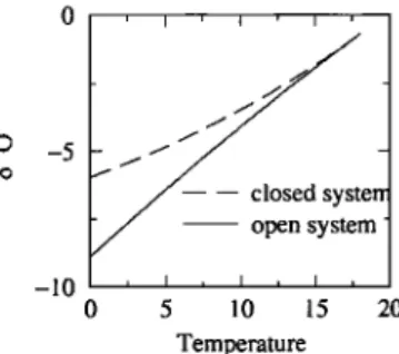
into account the presence of liquid water remaining in the cloud (Figure 4 and its caption). If all the liquid water precipitates (open system cloud, Rayleigh model), the
theoretical isotope-temperature slope is 0.54%o/øC in the
temperature range of 0 to +20øC; but if all the liquid is kept
into the cloud (closed system, important for convective
clouds), the simulated slope decreases to 0.29%o/øC. This
crude simulation supports the interpretation that the observed
low spatial slope is due to convective cloud droplets
reevaporation cycles.
An alternative approach to evaluate the impact of altitude
on the isotope-temperature relationship is to consider the 13
precipitation events occurring simultaneously at the three
stations, assuming that they correspond to synoptic processes
affecting the whole Urumqi River basin. The resulting slope of 0.30%o/øC (correlation coefficient 0.82) is intermediate
between the summer spatial slope (0.22%o/øC) and the spatio-
temporal slope calculated from all stations and all events
(0.55%o/øC). During these common events, a temporal slope
can be evaluated for each station: 0.46%o/øC at Urumqi,
0.61%o/øC at Yaojin Bridge and 1.28%o/øC at Daxigou (Table
3). We explain the non linear amplification of isotope-surface
temperature
changes
with altitude
by the cloud orogra•phy
lifting [Siegenthaler and Oeschger, 1980]. This should be
verified by measurements of cloud altitude along Urumqi
River Basin. 3. Conclusion
This study is based on continuous precipitation sampling and isotopic analysis (369 individual events) for three sites
representative of climate, land-surface and altitude
3476 YAO ET AL.: $•80 OF PRECIPITATION AND TEMPERATURE IN CHINA
closed
system_
0 5 10 15 20 Temperature
Figure
4. Simulation
of i5'80
in the liquid
phase
(%0)
versus
temperature
(ø,C) calculated
with an isotopic
model for an
isolated air mass initially at 20øC and 900hPa (Urumqi summer conditions) along its trajectory to a final temperature of 4øC and a pressure of 650hPa (Daxigou summer conditions). The evolution of the isotopic composition in the
liquid phase • depends on the mass of liquid water in the
cloud mL, the mass of water vapour mv, the fractionation coefficient et, following Jouzel (1986):
dmv da (a-I ) +-- mv 6t d& = (1 + dr) l+a mr mv
Two extreme cloud behaviors are calculated: the closed cloud
system, dashed line (all the liquid water is kept in the cloud)
and the open cloud system, solid line (Rayleigh model, all
condensate precipitates and mL=0).
fluctuations
of i51SO
in precipitation
at each site show
a
significant positive correlation with temperature fluctuations.
Due to the strong contribution of local recycling to summer
convective events, individual events show a weak linear
correlation with temperature fluctuations at high altitudes. When monthly averaging is performed, the correlation
increases dramatically and is really good (0.92) for the highest
location (4200m a.s.1.). The impact of temperature change on
the isotopic content is much stronger at high elevations (0.8 to
1.0) compared with the low elevation site (0.4), possibly due
to cloud orographic lifting. The spatial distribution of mean
i5180
among
the three
sites
also
shows
a positive
correlation
with temperature reflecting the lower altitude-temperature
dependency. The low spatial slope can be explained by the
role of liquid droplets in the convective clouds.
These observations, which should be extended in time and
include deuterium excess measurements, clearly show that
iS•SO
is a reliable
indicator
of temperature
in the high Asia,
and that the highest sensitivity to temperature should be obtained at the highest possible elevations. We now face the
challenge of obtaining deep ice cores from Tianshan mountain
glaciers.
Acknowledgements. This work was supported by Chinese National Project KZ951-A1-204-02, CAS Project KZ951-A1-402-03-
03 and the Tianshan Station Foundation. We thank U. von Grafenstein
and M. Delmotte for helpful comments on the manuscript. This is
contribution LSCE-0313.
References
Aizen, V.B., E.M. Aizen, J.M. Melack and J. Dozier, Climatic and
hydrologic changes in the Tien Shan, Central Asia, Journal of Climate, Vol. 10, 1393-1404, 1997.
Araguhs-Araguhs L., K. Froehlich and K. Rozanski, Stable isotope composition of precipitation over southeast Asia, Journal of Geophysical Research, Vol. 103, 28,721-28,742, 1998.
Cao
I•I.S.,
Detection
of abrupt
changes
in glacier
mass
balance
in
the Tien Shan mountains, Journal of Glaciology, Vol. 44, 352-
258, 1998.
Dansgaard, W., Stable isotopes in precipitation, Tellus, Vol.16,
436-468, 1964.
Jacob H. and C. Sonntag, An 8-year record of the seasonal
variation of 2H and •'O in atmospheric water vapour and
precipitation at Heidelberg, Germany, Tellus, 43B, 291-300,
1991.
Jouzel, J., and L. Merlivat, Deuterium and oxygen isotope in precipitation: Modeling of the isotope effects during snow formation, Journal of Geophysical Research, 89, 11,749-
11757, 1984.
Jouzel, J., Isotopes in cloud physics: multiphase and multistage
condensation processes, in Handbook of Environmental Isotope
Geochemistry, The Terrestrial Environment, (P. Fritz and J.-Ch.
Fontes, editors), B2, 61-112, 1986.
Jouzel, J. and others, Validity of temperature reconstructions from
water isotopes in ice cores, Journal of Geophysical Research,
Vol. 102, 26471-26487, 1997.
Lide T., T Yao and J Pu. Characteristics of /5•80 in summer
precipitation at Lhassa. Journal of Glaciology and
Geocryosphere (4) 19,295-301, 1997 (in Chinese).
Lorius, C., and L. Merlivat, Distribution of mean surface stable
isotope values in East Antarctica: observed changes with depth
in a coastal area, in Impurities in Snow and Ice, IAHS Publ.
118, 127-137, 1977.
Peel, D.A., R. Mulvaney and B. M. Davison, Stable isotope/air temperature relationships in ice cores from Dolleman Islands
and the Palmer Land Plateau, Antarctic Peninsula, Ann. Glaciol., 10, 130-136, 1988.
Qin D., Distribution of stable isotopes in surface snow along the
route of the 1990 International Trans-Antarctica Expedition,
Journal of Glaciology, Vol.40, 107-118, 1994.
Rozanski, K, Araguhs-Araguhs, L. ,Gonfiantini, R., Relation between long-term trends of oxygen-18 isotopecomposition
precipitation and climate, Science,Vol.258,981-985, 1992.
Siegenthaler U. and H. Oeschger, Correlation of •80 in
precipitation with temperature and altitude, Nature, 285, 314-
317, 1980.
Thompson L.G. and others, Holocene-late Pleistocene climatic ice core records from Qinghai-Tibetan plateau, Science, Vol. 246,
474-478, 1989.
Thompson L.G and others, Late glacial stage and Holocene tropical ice core records from Huascaran, Peru, Science, vol.
269, 46-50, 1995.
Thompson L.G. and others, A 25,000 year tropical climate history
from Bolivian ice cores, Science, Vol. 282, 1858-1864, 1998r
Yao T. and others, Characteristic of/5•80 in snow and its relation
with the moisture origin. Chinese Science Bulletin (20), 1570- 1573 (in Chinese), 1991.
Yao T. and others, Climatological significance of/5•80 in north
Tibetan ice cores, Journal of Geophysical Research, Vol.101, 29531-29537, 1996.
Yao T., Y. Shi and L. G. Thompson, High resolution record of paleoclimate since the Little Ice Age from the Tibetan ice cores, Quaternary International, Vol.37, 19-23, 1997a. Yao T. and others, The climatic record since the last Interglaciation
recorded in Guliya ice core, Science in China (series D),
Vo 1.40,662-668, 1997b.
Zhan•
X., Y. Shi
and
T. Yao,
Variational
features
of precipitation
/5•O in northeast Qinghai-Tibet Plateau, Science in China
(series B), Vol.38,854-864, 1995.
J. Keqin, Y. Tandong, S. Weizhen, Lanzhou Institute of Glaciology
and Geocryology, Chinese Academy of Sciences, Lanzhou, China.
J. Jouzel, V. Masson, M. Stievenard' Laboratoire des Sciences du Climat et de l'Environnement UMR 1572 CEA-CNRS, L'Orme des
Merisiers, Bit 709, CEA Saclay, 91 191 Gif-sur-Yvette c•dex, France. (e-mail: •nasson(• l•cc.sacia?.cea. I:r)
(Received: May 5, 1999; revised: July 27, 1999; accepted: September