__j
Decentralized On-board Planning and Scheduling for
Crosslink-enabled Earth-observing Constellations
by
Warren Grunwald
B.S. Mechanical Engineering, University of California at Berkeley (2012) Submitted to the Department of Aeronautics and Astronautics
in partial fulfillment of the requirements for the degree of Master of Science in Aeronautics and Astronautics
at the
MASSACHUSETTS INSTITUTE OF TECHNOLOGY
September 2019
@Massachusetts
Institute of Technology 2019. All rights reserved.Signature redacted
A uthor ... I...
Department of Aeronautics and Astronautics
Signature redacted
August 22, 2019Approved by...
Mark Abramson Principal Member of the Technical Staff The Charles Stark Draper Laboratory, Inc Technical Supervisor
Certified by...S..
ignature
redacted-...
Kerri Cahoy
Associate Professor of Aeronautics and Astronautics Thesis Supervisor
Acceptedby...
Signature
redacted
MASSACHUSETTNS ITTE
Sertac Karaman
Associate Professor of Aeronautics and Astronautics
I
Decentralized On-board Planning and Scheduling for
Crosslink-enabled Earth-observing Constellations
by
Warren Grunwald
Submitted to the Department of Aeronautics and Astronautics on August 22, 2019, in partial fulfillment of the
requirements for the degree of
Master of Science in Aeronautics and Astronautics
Abstract
Small satellites have improved in capability, nearing a future where high data-rate payloads and crosslinks can provide improved geospatial and temporal coverage, while at a fraction of the cost. Planning and scheduling for efficient bulk data routing with discrete crosslink windows in a dynamic network is a difficult combinatorial optimiza-tion problem [30]. As problem size grows, quickly solving the planning and scheduling problem involves implementing algorithms that can leverage parallelization. Decen-tralized algorithms are inherently parallelizable and can be implemented on-orbit by individual satellites.
This thesis investigates a decentralized approach that builds upon the Coupled Constraints Consensus Based Bundle Algorithm (CCBBA) with enhancements to ad-dress maximum flow problems. Maximum flow problems occur when moving some resource from sources to sinks across a network, such as a satellite constellation ob-serving targets (sources), moving data between satellites with crosslinks, and down-linking to ground stations (sinks). The CCBBA enhancements include task forking, task outflow coupling, and dynamic task creation based on satellite flow direction preferences. These enhancements increase the total data throughput and decrease re-quired runtime. When implemented on each satellite, this decentralized auction-based approach, named Iterative-CCBBA for Maximum Flow problems (ICMF), provides the following benefits: 1) has robustness in convergence to differences in agent situ-ational awareness, 2) decouples operations from ground station planning resources, and 3) provides an inherently parallelizable algorithm, if implemented on the ground instead of each satellite.
ICMF is compared to a state of the art Centralized Global Planner (CGP) in six test cases, with two different inclinations and three different numbers of total satellites. Across all six unique use cases, ICMF has linear scaling in number of consensus rounds and, on average, runs in 94% less time than the CGP, with a 4% improvement in total data volume delivered. ICMF is an effective planner for satellite constellations that value total data throughput and runtime efficiency. The CGP performs better on median latency for observations and median average target
age of information, performing better by 58% and 23%, respectively. Future work options for incorporating additional data routing information that could help close the latency and target age of information gap while still using a decentralized approach are presented.
Thesis Supervisor: Kerri Cahoy
Contents
Acronyms 17
Symbols 19
1 Introduction and Motivation 23
1.1 Small Satellite Capability Growth ... 23
1.2 Coordination of Small Satellite Constellations . . . . 24
1.3 Motivation for Decentralized Planning and Scheduling . . . . 25
2 Background and Literature Review 27 2.1 Small Satellites and Bulk Data Routing . . . . 27
2.1.1 Proliferation of Small Satellite Constellations . . . . 27
2.1.2 Bus Capabilities . . . . 29
2.1.3 High Data Rate Payloads . . . . 30
2.1.4 Laser Communications Crosslinks . . . . 31
2.2 Coordinated Small Satellite Constellations . . . . 32
2.2.1 Benefits of Coordination . . . . 33
2.2.2 Planning Communication Architectures . . . . 34
2.3 Multi-agent Planning and Scheduling . . . . 36
2.3.1 Trade-offs in Different Approaches to Coordination . . . . 36
2.3.2 Centralized and Semi-Centralized Approaches . . . . 39
2.3.3 Decentralized Approaches . . . . 45
2.4.1 Decentralized Max-Flow Approaches . . . . 52
2.4.2 Implementing Max-Flow Algorithms for Small Satellites . . . . 53
3 Approach 55 3.1 Framing the problem . . . . 55
3.1.1 Definitions and Assumptions . . . . 56
3.1.2 Mathematical Formulation . . . . 62
3.1.3 Test Cases . . . . 67
3.2 Enhancements to CCBBA to Address the Max Flow Problem . . . . 68
3.2.1 Motivation for modifying CCBBA . . . . 70
3.2.2 Pre-coordination Phase . . . . 71
3.2.3 Bundle Phase Modifications - Task Forking and Flow-Based C oupling . . . . 74
3.2.4 Consensus Phase Modification -Exact Time Matching and Flow State Sharing . . . . 84
3.3 Iterative CCBBA for Max Flow problems (ICMF) . . . . 91
3.3.1 Improving Convergence of Valuable Reception Crosslinks . . . 91
3.3.2 Considerations for Making Transmission Crosslinks Multibid . 95 3.3.3 ICMF interfaces for on-board planning . . . . 98
3.4 Greedy Routing Algorithm . . . . 99
3.4.1 Routing Requirement . . . . 100
3.4.2 Minimizing Latency and Age of Information from ICMF Tasks 102 4 Results 107 4.1 Observations and Downlinks Only Results . . . . 107
4.1.1 30 degree inclination constellation . . . . 108
4.1.2 60 degree inclination constellation . . . . 110
4.2 Selecting Optimal ICMF Parameters for Test Cases . . . .111
4.2.1 Iterative CCBBA for Max Flow problems (ICMF) Algorithm Parameters . . . .111
4.2.3 Bounds on consensus rounds required for convergence . . . . . 114
4.3 ICMF Performance against Centralized Planner . . . . 116
4.3.1 Centralized Planner Configuration for on the same Test Cases 118 4.3.2 30 degree inclination constellation . . . . 121
4.3.3 60 degree inclination constellation . . . . 124
5 Conclusion 127 5.1 Contributions Summary . . . . 127 5.2 Future W ork . . . . 128 5.2.1 ICMF Improvements . . . . 128 5.2.2 On-orbit Planner . . . . 131 A Full Schedules 135 A.1 30 degree inclination constellation . . . . 136
A.2 60 degree inclination constellation . . . . 139
B Additional Properties, Methods, and Pseudocode 143 B.1 Object Properties and Methods . . . . 143
List of Figures
2-1 Performance benefits of adding crosslinks [30 . . . . 43
2-2 Computation and simulation pipeline used in Scheduling Planning Rout-ing Inter-satellite Network Tool (SPRINT) [30] . . . . 44
2-3 Summary of how CCBBA handles mutual dependence . . . . 51
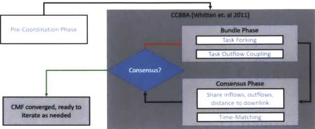
3-1 Simplified CCBBA loop with modifications for CCBBA for Max Flow (CMF) shown in the white boxes with light blue text . . . . 56
3-2 General objective function and constraints for CMF, annotated for satellite BD RP . . . . 62
3-3 Example base task value . . . . 64
3-4 Example task value evaluated for an agent with tasks already in its bundle . . . . 65
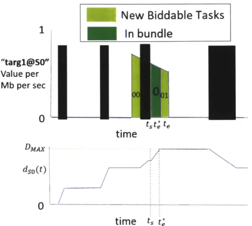
3-5 Example of a satellite's state over the planning horizon . . . . 67
3-6 Results contain 10,20, and 30 satellites per plane. In (a), green dots represent observation targets, blue squares are the ground stations, and red lines are the satellite ground tracks. This is a densely packed con-stellation with frequent crosslinks and saturated observation schedule. 69 3-7 Results contain 10,20, and 30 satellites per plane. In (a), green dots represent observation targets, blue squares are the ground stations, and red lines are the satellite ground tracks. . . . . 70
3-8 Example of downlink windows that need to be deconflicted . . . . 73
3-9 Deconflicting downlink tasks . . . . 74
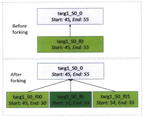
3-11 Example task that would break data state if full duration was added 77
3-12 Forked tasks from adding feasible portion of a single task . . . . 78
3-13 Forked ExecutableTasks relationship to original Task . . . . 79
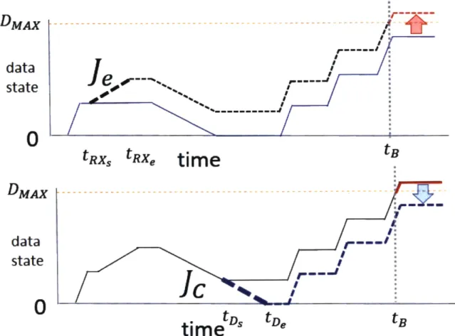
3-14 Example of Task Outflow Coupling Repairing Data State . . . . 81
3-15 Recursion Step in Implementation of Task Outflow Coupling . . . . . 82
3-16 Example satellite schedule highlighting the modifications to the bundle phase of CCBBA . . . . 83
3-17 Annotated tables highlighting the impact of the bundle phase modifi-cations to the 30 satellite test cases. . . . . 83
3-18 Example of Time Matching Algorithm Creating New Crosslinks . . . 85
3-19 Performance of fixed crosslink windows . . . . 88
3-20 Example of flow direction state . . . . 89
3-21 Performance of flow based crosslink windows . . . . 91
3-22 Diagram showing the outer loop of ICMF, which iterates rounds of CMF. 93 3-23 Example of ICMF convergence with 90 satellites . . . . 96
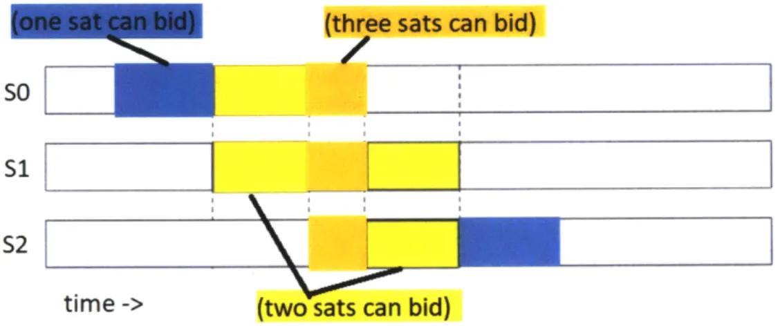
3-24 Example of TX crosslinks that result from different TXmultibidvalues 97 3-25 Graphical view of single bid vs. multibid TX crosslinks . . . . 97
3-26 Possible ICMF functional interfaces to other satellite subsystems. . . 100
3-27 Simple Age of Information (Aol) example calculation with one obser-vation . . . 102
4-1 Downlink and Observations only results for 30 degree inclination test case. . . . . 109
4-2 Downlink and Observations only results for 60 degree inclination test case. . . . .111
4-3 Parameter Study: DV and Runtime Performance . . . . 115
4-4 Consensus rounds for each unique parameter setting. . . . 117
4-5 Metrics and Runtime Results for 30 degree inclination constellation . 122 A-1 Legend for satellite schedules. . . . . 135
A-3 60 satellites: Full Schedule for 30 deg inclination constellation. (satel-lites 1-30) . . . 137 A-4 60 satellites: Full Schedule for 30 deg inclination constellation.
(satel-lites 31-60) . . . . ... . . . 138 A-5 30 satellites: Full Schedule for 60 deg inclination constellation. . . . . 139 A-6 60 satellite: Full Schedule for 60 deg inclination constellation.
(satel-lites 1-30) . . . 140 A-7 60 satellite: Full Schedule for 60 deg inclination constellation.
List of Tables
2.1 Small Satellite Categories by Mass [37] . . . . 28
2.2 Near Earth Network (NEN) Ground Station Parameters [41] . . . . . 29
2.3 Assumed notional 6U CubeSat Subsystem Capabilities . . . . 33
3.1 State Impacts of Each TaskType . . . . 66
3.2 Use case names and number of unique activity windows. . . . . 69
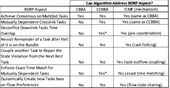
3.3 Comparison of CBBA, CCBBA, and ICMF in addressing key aspects of the Bulk Data Routing Problem (BDRP) . . . . 72
4.1 SPRINT CGP Results for All Use Cases . . . . 120
4.2 30 deg inclination results: comparison to SPRINT in same units . . . 123
4.3 30 deg inclination results: comparison to SPRINT as a performance m ultiplier . . . . 123
4.4 Metrics and Runtime Results for 60 degree inclination constellation 124 4.5 60 deg inclination results: comparison to SPRINT in same units . 125 4.6 60 deg inclination results: comparison to SPRINT as a performance m ultiplier . . . . 125
List of Algorithms
1 Task Forking . . . . 78
2 Crosslink Time Matching . . . . 86
3 Flow Direction Preference Calculation . . . . 90
4 Iterative CCBBA for Maximum Flow problems (ICMF) . . . . 94
5 Greedy Routing Algorithm Post Activity Selection . . . . 106
Acronyms
ADCS Attitude Determination and Control Subsystem ADEPT All-Domain Execution and Planning Technology Aol Age of Information
ASPEN Automated Scheduling and Planning ENvironment AWS Amazon Web Services
BDRP Bulk Data Routing Problem
CBBA Consensus Based Bundle Algorithm
CCBBA Coupled Constraints Consensus Based Bundle Algorithm CGP Centralized Global Planner
CLICK CubeSat Laser Infrared CrosslinK CMF CCBBA for Max Flow
DARPA Defense Advanced Research Projects Agency DV Data Volume
GA Genetic Algorithm
GPS Global Positioning System
LCCC Limited Communication Constellation Coordinator LEO Low Earth Orbit
MILP Mixed Integer Linear Program
MIT Massachusetts Institute of Technology
NASA National Aeronautics and Space Administration
NEN Near Earth Network
NODE Nanosatellite Optical Downlink Experiment
OAP Orbit Average Power
PAT Pointing, Acquisition, and Tracking
RAM Random Access Memory
RX Reception Crosslink
SLO San Luis Obispo
SPRINT Scheduling Planning Routing Inter-satellite Network Tool
SSTP Small Spacecraft Technology Program
STAR Lab Space Telecommunications, Astronomy and Radiation Laboratory
TX Transmission Crosslink
Symbols
To facilitate understanding of this thesis, some of the pseudocode will use an object-oriented style. The objects are included at the end of this symbol list, see Appendix B for definitions of all properties and methods.
Nu total number of agents
Nt total number of tasks
Lt task bundle size limit
Nsteps total timesteps in the planning horizon
I set of all agents
set of all tasks
T set of all timepoints in the planning horizon
Ii set of all agents that can bid on Task with index
j
fi set of all Tasks biddable by Agent with index ijexec set of all ExecutableTasks biddable byAgent with
index i
xi assignment vector for Agent with index i, xi
{0, I}N
bi task bundle for Agent with index i, ordered by de-creasing task value
pi task path for Agent with index i, ordered by in-creasing task start time
ejdsx diam di(t) e (t) a (t) DMAX DMIN beype(ai (t)) Etype (ai (t)) DJ.type E.type Ei(t) Kchg I J Je
Ev (ei (t),I Je)
Dv(di(t), Je)U
Rc
U61°
insertion symbol. Inserts the argument on the right into the argument on the left at the location de-noted by idx
diameter of a communication networks; measures the maximum number of hops between any two agents in the network
data state for Agent with index i at time t energy state for Agent with index i at time t activity state for Agent with index i at time t maximum data storage on board a satellite minimum data storage on board a satellite data rate from activity at time t
energy rate from activity at time t data rate from activity of type Je.type energy rate from activity of type Je.type
sunlight tracker for Agent with index i at time t: 1 for sun, 0 for eclipse
charging rate when in sunlight
Agent object, has agent-unique index i Task object, has task-unique index
j
ExecutableTask object, has executable task-unique fork number
je
data state violation from adding EecutableTask
Je to the bundle
energy state violation from adding ExecutableTask
Je to the bundle
number of communication rounds within the con-sensus phase
mutual dependence counting parameter for Agent with index i to bid solo on Task with index
j
vii
itersMAX
TXmultibid
Je.forkable E {T, F} forkj,(newTaskInds)
timeout parameter for Agent with index i for Task with indexj
ICMF algorithm parameter: (integer) sets number of CMF rounds that are iteratively executed ICMF algorithm parameter: (boolean) determines if new crosslinks created are multibid (True) or sin-glebid (False)
object property example object method example
Chapter 1
Introduction and Motivation
The purpose of this thesis is to present an algorithm based on set of enhancements to the Coupled Constraints Consensus Based Bundle Algorithm (CCBBA) decentralized task allocation algorithm that can solve maximum flow problems that arise in Earth observing satellite constellations. Maximum flow problems involve moving a resource, such as observation data, from a set of sources to a set of a sinks across a network. The new algorithm, known as ICMF, is presented with simulation results for solving a
Bulk Data Routing Problem (BDRP) with small satellites. Bulk data routing means transmission of raw data that is observed by any satellite in the constellation to any ground station in the network. The bulk data routing problem is solved with a feasible plan for each satellite in the constellation which optimizes for total data throughput, with a preference for lower average observation latency and lower average age of target information. The problem is described in more detail in Section 2.4.
1.1
Small Satellite Capability Growth
A 'small satellit' is any satellite that is less than 180 kg, according the National Aeronautics and Space Administration (NASA) Small Spacecraft Technology Pro-gram (SSTP) [371. CubeSats will soon be capable of supporting high-data rate pay-loads, such as hyperspectral imagers
[34,
59] and video [16], with laser communication crosslinks and downlinks [6, 44, 22] to achieve tens of Gb downlinked per orbit of valuable scientific data. Overall, the data delivered by small satellites is expected todouble from 2020 to 2030, reaching up to 3.9 exabytes [581 (exabyte = 1012 MB) over that decade. In addition to the cost and performance benefits, networks of satellites also have higher resilience against anti-satellite actions [12]. However, for small satel-lites to achieve this level of data throughput, the satelsatel-lites need to coordinate their actions across the constellation.
1.2
Coordination of Small Satellite Constellations
Efficient coordination of many satellite actions in a constellation, such as SpaceX's proposed Starlink constellation [52], especially with mutually dependent tasks such as laser communication crosslinks, requires solving challenging planning and scheduling problems. Current methods involve framing the planning and scheduling problem as an optimization. Because these optimization problems are usually computationally taxing, schedules have been computed at ground stations and then uplinked to the satellites. Some missions only require observations and downlinks to be scheduled, such as the Planet Labs mission which uses CubeSats to image the entire landmass of Earth every day. Their approach uses simulated annealing to solve the optimization in a non-deterministic way [51]. Other non-deterministic methods have been demon-strated in simulation. Zheng et al. showed a coordination approach for a constellation with intersatellite communication between one 'mother satellite' and multiple 'daugh-ter satellites' using a genetic algorithm [62].
However, there are limited results for large constellations with crosslinks enabled between all satellites. Zhou et al. demonstrated a contact plan approach that could effectively plan for a six-satellite constellation in two near polar orbits that scaled well with planning horizon, but did not show scaling results as the constellation size increased [65]. Scaling effectively with the number of satellites is critical for crosslink-enabled constellations because the number of possible routes that data can take from the observation point to a downlink opportunity scales at least exponentially with the number of satellites because the number of simple paths in the communication graph grows factorially in the worst case [24]. Andrew Kennedy's 2018 PhD thesis addressed this problem by using a route downselection phase to limit the number of
routes considered per observation to a constant value
[30].
Kennedy demonstrated that the problem could scale polynomially, if parallel processing is used for the route downselection [29]. However, both Kennedy's and Zhou's methods require all of the problem information to be in one location and to have sufficient computational resources in that location. The centralization of information and processing power provides a large roadblock to implementing these methods on-orbit.1.3
Motivation for Decentralized Planning and
Schedul-ing
Using a decentralized approach for planning and scheduling has two main benefits. The first is that decentralization naturally works with parallelization because it is intended for use by multiple agents. If a constellation operator wants to implement the methods at the ground station, they could run a decentralized algorithm on parallel processors and reap the benefits of on-demand computation services, such as Amazon Web Services (AWS), more easily. However, the ultimate goal with decentralized methods is to deploy them in flight software orbit. Deploying the algorithms on-orbit could be done with centralized algorithms, but places a larger computational burden on one satellite instead of spreading it around the entire constellation. In most decentralized algorithms, each agent is executes a relatively simple set of procedures and the problem is solved by the combined effort of all agents.
This leads to the second main benefit of decentralized methods: the ability to execute the mission with minimal required ground station direction. This leads to many more specific positive aspects, such as:
" Lower ground station staffing requirements and no requirement to centralize all planning information in one location for each planning session.
• Robustness to correlated ground station failures.
" Ability to autonomously handle distributed user requests. If the constellation is serving a distributed user base that has tactical uplink terminals, then direct requests to the constellation may be more feasible then communicating back to
a ground station to incorporate a task into the next plan. The satellites can accumulate tasks on-orboard and use them in the next planning cycle. Or if the tasks are high priority enough, then they can trigger a new replan to serve the users more immediately and directly.
In this thesis, ICMF was developed from a general decentralized task allocation algorithm that can handle coupled constraints, known as CCBBA. ICMF introduces several key new enhancements to CCBBA [61] to increase performance and conver-gence time for BDRPs. The enhancements are: task forking, task outflow coupling, exact time matching, flow-preference sharing, and iterative new task creation. With these enhancements, ICMF is compared to a state of the art centralized planner in six test cases, resulting in 94% less runtime with a 4% improvement in total data volume delivered, averaged over the six cases.
The next chapter in this thesis starts with reference material on multi-agent plan-ning and scheduling. Then max-flow problem and different solutions are summarized, since the BDRP is a specific instance of a max-flow problem. Chapter 3 describes the BDRP mathematically, presents the specific use cases that are tested, and describes ICMF in detail. Chapter 4 presents the results when varying the ICMF parameters and the performance against a state of the art centralized planner. Finally, Chapter 5 summarizes findings and describes areas for future work.
Chapter 2
Background and Literature Review
This chapter focuses on the capabilities of small satellites and the algorithmic back-ground. First, small satellite capabilities and approaches for satellite constellation coordination are reviewed. Next, multi-agent planning and scheduling is reviewed, with an emphasis on how the problem can be solved with different levels of autonomy for the satellite. Then, decentralized approaches for planning and scheduling are dis-cussed. Finally, ideal max flow problems and algorithms are presented in the context of laser communication enabled bulk data routing.
2.1
Small Satellites and Bulk Data Routing
This section will describe the capabilities of small satellites, focusing on the ability to route large of amounts of data with increased throughput, latency, and resilience.
2.1.1
Proliferation of Small Satellite Constellations
According to the NASA SSTP, a satellite is a 'small satellite' when its wet mass is below 180 kg. There are four main subcategories of small satellites in this range shown in Table 2.1 [37].
Table 2.1: Small Satellite Categories by Mass [37]
Over the past ten years, small satellites have come to dominate the number of satellites launched, especially CubeSats. This thesis focuses on 6U CubeSats, which are still considered nano-satellites even though their mass can be to 12 kg [33]. Cube-Sats were proposed in 1999 by Bob Twiggs at Stanford and Jordi Puig-Suari at Cal Poly San Luis Obispo (SLO) with the development of a standard launcher and bus as a way to help university students build and launch satellites on a low-cost platform [47]. The first CubeSat launch occurred in 2003, and by the end of 2012, over 100 had been launched, mostly by universities [57]. As the technologies for CubeSats matured and the students working on them entered the work force, more commercial entities became interested in the capabilities of CubeSats. By 2014, the majority of CubeSat launches were commercial and there were over 40 new companies established aiming to leverage small satellite capabilities [58]. This planned growth of small satellite constellations also lead to increasing ground station and operator requirements to coordinate and schedule the growing number of satellites in orbit.
This thesis assumes that the satellites use the NASA NEN for ground stations. The NEN consists of ten ground stations around the world, some with multiple an-tennas, that can provide downlink and uplink support for satellite missions. NASA's analysis shows that the NEN has difficulty supporting equatorial CubeSats, but can support additional capacity for inclined and polar CubeSat constellations [53]. The ten NASA NEN ground station locations are summarized in Table 2.2. Note that some of these locations have multiple antennas with different abbreviations and that these are the same locations and abbreviations that will be seen in Chapters 3 and 4 of this thesis when discussing the test cases and results.
Name Mass Range (kg)
Mini-satellite 500-100
Micro-satellite 100-10
Nano-satellite (CubeSat) 10-1
Station Location Abbrev. Lat (deg) Lon (deg) Fairbanks, Alaska, USA ASI 64.8587 -147.8576
McMurdo, Antartica MG1 -77.8391 166.6671
Wallops, Virgina, USA WG1 37.9249 -75.4765
SSC South Point, Hawaii, USA USHIO1 19.014 -155.6633
SSC Kiruna, Sweden KU1S 67.8896 21.0657
SANSA, South Africa HB5S -25.8869 27.7067
SSC Dongara, Australia AUWA01 -29.0457 115.3487 KSAT TrollSat, Antartica TR2 -72.0022 2.0575
KSAT Svalbard, Norway SG1 78.231 15.389
KSAT Singapore S11 1.3962 103.8343
Table 2.2: NEN Ground Station Parameters [41]
To provide additional ground station services to the small satellite market, AWS has entered the ground station business in a joint venture with Lockheed Martin to provide ground station capabilities as a service [17]. The capability to have the data reception, processing, and storage handled by a separate entity could drive satellite and mission providers to develop on-board planning and scheduling capabilities so their planning segment isn't tied to a specific ground segment and they can pursue different options for ground station services without worrying about the planning and scheduling software compatibility. This is just one potential motivating factor for pursuing a decentralized planning and scheduling approach. However, to perform on-board planning and scheduling, the satellite bus has to be capable enough to execute the mission and carry the overhead for additional computation and communication.
2.1.2
Bus Capabilities
As CubeSats became more popular for university projects, commercial companies improved the capabilities of nearly every subsystem. For example, initially single junction solar panels with an efficiency of 16.9% were directly mounted to the surface, while now there are deployable solar panels with triple-junction GaAS solar cells
with efficiencies up to 33% [37]. Prices for the various subsystems has also decreased significantly over time due to the large market for CubeSat subsystems and the bus standard published by Cal Poly SLO [13]. Some vendors offer the entire CubeSat bus, with a specified payload interface for power, data, and mechanical so that the customer can focus on payload and mission applications. One example is the nano-avionics M6P 6U Satellite Bus [401.
The propulsion unit [39] takes up 1U of space in the M6P 6U Satellite Bus, so there is up to nearly 5U available for the mission payload and communications equipment when the propulsion unit is removed. By modifying that bus with additional solar panels similar to the deployable solar panels used by the MarCO mission, the orbit average power generation can reach up to 36 W
135].
By removing the propulsion unit, adding an X-band downlink antenna compatible with the NASA NEN [43], additional computer for planning and scheduling, and two additional battery cells, this thesis assumes the bus capabilities outlined at the end of this section in Table 2.3.The capabilities in Table 2.3 are used to represent the state constraints in the plan-ning and scheduling problem. The physical basis for the rest of the activity param-eters used in this thesis, observations and crosslinks, are presented in Sections 2.1.3 and 2.1.4 and are reviewed in Section 3.1.2.
2.1.3
High Data Rate Payloads
Traditionally, high data rate payloads, such as hyperspectral imagers, required a large satellite bus and expensive launch vehicle. For example, the NASA Earth Observing 1 (EO-1) mission launched in 2000 and cost over $200 M to develop [34]. However, NASA has proposed a follow-on mission that leverages the recently developed Head-wall Nano-hyperspec instrument, which can fit on a CubeSat and generates 0.5-1 Gbps of raw data, for a total mission cost below $5 million. While the best reso-lution is limited by the size of the CubeSat aperture, using a constellation of these CubeSats would provide much higher revisit time and more data at a fraction of the development and launch costs [34]. The NASA CubeSat hyperspectral imager is still in study phases, but with more integration effort, even better performance can be
achieved, such as the multi-spectral imager generating about 5 Megabits per picture (1 Mb per band) proposed by Tsitas and Kingston that fit on an 8 kg CubeSat and has similar payload and downlink capabilities when compared with a 150 kg satellite
[59].
Gathering video from space is another mission that small satellites can soon fulfill. One company, Skybox Imaging, used 83 kg satellites to provide the first ever high definition video (above 50 Mbps data generation) from space [16]. This company was acquired by Planet Labs in 2017 [58]. Planet Labs operates a fleet of over 100 small satellites, mostly 3U CubeSats, to provide imagery of over 150 million km2 every day [51]. As these examples demonstrate, there is a large and growing market for dense data products with improved latency. With the proliferation of CubeSats and the ability to fly high data rate payloads, the amount of data to be downlinked by small satellites is expected to double in the next decade, reaching up to 3.9 exabytes [58] over 10 years. This leads to a challenge for energy-limited and storage-limited CubeSats, because the data downlinked per unit energy is not yet high enough using UHF and S-band radios, as shown in Clements et al. [11].
For higher data rate payloads, CubeSats need to leverage more efficient downlink methods, such as X-band radio or laser communications. If a laser communication payload, which is also capable of cross-linking with other satellites, is used, this can increase total mission performance, because using crosslinks can achieve +25% throughput and up to 75% reduction in latency, which is discussed in more detail in Section 2.3.2 and Figure 2-1.
2.1.4
Laser Communications Crosslinks
Recent efforts in the Massachusetts Institute of Technology (MIT) Space Telecom-munications, Astronomy and Radiation Laboratory (STAR Lab) have focused on developing and demonstrating laser communication crosslinks for CubeSats. First, Nanosatellite Optical Downlink Experiment (NODE) was developed to show the fea-sibility of an optical downlink on a CubeSat at a data rate up to 43 Mbps and demon-strated the feasibility of a low-cost laser communications ground terminal known as
PorTeL 111, 50]. Then, the CubeSat Laser Infrared CrosslinK (CLICK) CubeSat was developed to show the feasibility of closing a laser communications link between CubeSats, especially the Pointing, Acquisition, and Tracking (PAT) capability, and is capable of achieving up to 25 Mbps at 920 km range with a size of 1.5 U [6, 44, 22]. With the small form-factor of the CLICK payload, it is feasible to have a primary payload, such as a hyperspectral imager, on a 6U CubeSat as well.
Crosslinks make the optional planning and scheduling problem harder (NP-Hard) because optimal solutions require information about all possible paths between ob-servations and downlink, referred to as data routes. The number data routes scales exponentially in the number of satellites since there are an exponential number of simple paths in an undirected graph [24]. Solving the crosslink-enabled bulk data routing problem efficiently is the main focus of this thesis and will be discussed in detail in Chapter 3.
By allocating 1.5U of payload space to a laser communications payload, 1U of payload space to the hyperspectral imager and processing electronics, and 1.5U of space to an additional planning computer, Global Positioning System (GPS) receiver, and Xband radio electronics, this thesis assumes the capabilities shown in Table 2.3 for a notional crosslink-enabled hyperspectral imaging 6U CubeSat.
2.2
Coordinated Small Satellite Constellations
Coordination in this context is defined as leveraging information about what ac-tivities other satellites plan on executing to determine what acac-tivities a particular satellite should execute. Coordination could occur on the ground, where a central-ized planner has access to information about all the satellites, or on-board, where the satellites communicate with each other to adjust their plans. One example of a satellite constellation with minimal coordination is the GPS constellation, where each satellite is set to broadcast a signal repeatedly and the actions of the other satellites have little to no impact on the plan for that satellite. A planned constellation with high levels of coordination is the SpaceX Starlink constellation, where over 10,000 satellites must coordinate constantly for low latency routing decisions
[23].
Subsystem Capability
Payloads Hyperspectral Imager and Laser
Communi-cations Crosslink Power Generation (Orbit Average 30 W
Power (OAP))
Power Storage 10 cells, 8.0 V, 13.8 Ah
Attitude Determination and Con- 3-axis stabilized, rate: 10/s, control: ±0.1° trol Subsystem (ADCS)
Orbit Determination GPS Receiver (0.5U and 1W power) [55]
Bus base power draw 10 W
Data Storage 12 Gb Solid State Memory
Downlink Rate -20 Mbps at 20 W total power draw Observation Rate +50 Mbps at 10 W total power draw Crosslink Transmission -10 Mbps at 20 W total power draw Crosslink Reception +10 Mbps at 5 W total power draw Table 2.3: Assumed notional 6U CubeSat Subsystem Capabilities
2.2.1
Benefits of Coordination
As mentioned in Section 2.1.4, crosslinks can significantly increase the complexity of coordinating the activities of a constellation. Crosslinks inherently require coordina-tion because a transmission and recepcoordina-tion crosslink are mutually dependent on each other. However, even in the no-crosslink case, coordination can still be required to deconflict downlinks from multiple satellites to the same ground station at the same time since this thesis assumes that a ground station can only point to and receive data from one satellite at a time. This occurs when more than one satellite is in view of the same ground station, which will happen if the constellation has enough satellites or the satellites are clustered together. Since CubeSats are usually launched as secondary payloads, they are likely to be clustered together and must use differen-tial drag or propulsion to space themselves out within the orbit. In either case, the constellation will have radio frequency interference and/or dropped data packets if there is not coordination between satellites on scheduling the downlink activities.
There are many other potential benefits of mission level coordination, includ-ing multi-modal sensinclud-ing [14], distributed aperture radar missions [54], and reactive constellations [1, 38]. Multi-modal sensing missions, such as the Defense Advanced
Research Projects Agency (DARPA) BLACKJACK program, need to coordinate to have heterogeneous payloads collect on the same target at specific times to gather temporally correlated data [14]. For distributed aperture radar missions, such as the Air Force's TechSat 21 program, coordination is required to set the radar imaging baseline to achieve high resolution images [54]. Reactive constellations are those that coordinate to exploit new information gained by some satellites (or ground operators) to replan selectively with satellites that have fast slewing capabilities [1, 38]. For ex-ample, if a satellite observed Target A and did some initial processing that resulted in a higher priority that initially assumed, it would broadcast this information which might result in other satellites slewing to view Target A instead of their original plan. Truly reactive constellations require advanced autonomy to process the observed data accurately and reason correctly about the decision to abandon the current plan based on the new information. While there are other benefits of constellation coordination, this thesis will focus on coordination for the purposes of solving the bulk data routing problem and enabling future reactive constellation capabilities.
2.2.2
Planning Communication Architectures
To achieve coordination among satellites in a constellation, there are several commu-nication architectures available for small satellites. In order of decreasing planning information latency, the communication architectures covered in this thesis are:
1. Ground Station Contact only: this is the traditional method of managing a satellite constellation, where planning information is only transmitted from a ground station when a satellite passes overhead. Assuming there is network connectivity between all of the ground stations, this allowed for a centralized planning algorithm to gather telemetry and payload data from all the satellites as they pass overhead and uplink new schedules. The coordination between satellites occurs indirectly in the centralized planning algorithm and the satel-lites do not have any direct information transfer between each other. This communication method is the simplest for the satellite software since there is no onboard planning or inter-satellite communication required.
2. Ground Station Contact plus Radio Crosslink Plan Dissemination: this method is the same as method 1, except that now satellites share new planning informa-tion with their neighbors via radio crosslinks. This approach was demonstrated to improve mission performance in average revisit time using a weak consensus mechanism in the Limited Communication Constellation Coordinator (LCCC) algorithm [29]. However, this approach increases satellite bus complexity and requires additional radio communications to be planned in the activity schedule and power budget, while also still requiring ground stations to develop the new plan.
3. Ground Station Contact plus Intersatellite Backbone Plan Dissemination: this method is the same as method 1, except that there is an assumed communi-cations backbone constellation that the small satellites can also all interface with to receive planning updates. This method has very low plan dissemination latency since all the satellites in the constellation can receive the information shortly after it is uplinked to the communications backbone without scheduling radio crosslinks with each other. This has been demonstrated with CubeSats and the Iridium communications constellation with the PicoPanther satellite [52]. There have also been simulations showing that this type of architecture, where the mission constellation is at a lower altitude than the communications constellation, provides more robustness to total satellite failures and better per-formance for similar cost values
[12].
4. Radio Crosslink only: In this approach, there is no dynamic planning informa-tion from the ground stainforma-tions and the satellites have to develop and disseminate the plan with crosslinks only. Satellites still receive static planning information from the ground as a starting point. This static information concerns aspects of the mission that are not expected to change between planning horizons, such as the location of the ground stations and the observation targets. The satel-lites still have to deconflict mission data downlinks to ground stations and let the ground station know which satellite has a downlink scheduled at each time
point. This has the highest complexity requirement on the satellite, but it frees up ground station planning resources for other constellations and also means that the satellite constellation is robust to ground station failures. This setting naturally lends itself to decentralized planning algorithms, but they must be able to handle the complex, coupled constraints of satellite missions with laser communications crosslinks. Since the satellites are developing the plan them-selves, as soon as it is updated and consensus is achieved, all of the satellites already know the plan so there is no plan dissemination latency that would be added ontop of plan generation time since the time between plan convergence and dissemination is zero. Note: that does not mean that the replan time is zero since a disruption that requires a replan will require a new consensus to be achieved.
2.3
Multi-agent Planning and Scheduling
Multi-agent planning and scheduling covers a large set of potential applications. Traditionally, planning was done in a central location with all of the information about the problem represented in a mathematical model that could be solved. A planner that uses all of the problem information at once and then directs all of the agents is known as a centralized planner. For satellites, the location of the centralized planner is generally on the ground, but it could also be a special satellite on-orbit. If the satellites can decide on their own activities, but don't communicate directly with each other, instead going through one information hub satellite for coordination, then this is referred to as a semi-centralized approach because there is a still a single location where all information passes through. A truly decentralized approach has all satellites communicating directly with each other and the communication network is coupled with the agent's path (or each satellite's orbit, in the satellite network case).
2.3.1
Trade-offs in Different Approaches to Coordination
The fundamental trade-off between centralized, semi-centralized, and decentralized planning and scheduling algorithms is based on where the required information andcomputing resources are located and how they interact during planning. For all three types, this thesis reviews limited planning horizon algorithms, where a specific time into the future is planned for. The difference between the three approaches can be summarized as:
" Centralized algorithms aggregate all information and use it one shot to solve the problem for a given time horizon. Because of this aggregation, there can gen-erally be optimality guarantees for deterministic centralized methods, although the solutions are usually intractable because solving the BDRP with routing for individual observations, not just routing for bulk data, is NP-hard. So heuristic or randomized methods are usually employed to selectively throw away por-tions of the aggregated information. Both types of algorithms, heuristic and randomized, are discussed in Section 2.3.2.
" Semi-centralized algorithms still aggregate all information in one place, but the information might not all be there at the same time and the decisions could be made in a distributed way. This is the most general category, meant to catch the planning approaches that fall between centralized and decentralized.
Optimality guarantees depend on whether information consistency is enforced, such as in the implicit coordination algorithm with perfect information 12]. Approaches that have demonstrated results for satellite networks are discussed in Section 2.3.2.
" Decentralized algorithms rely on agents communicating directly with each other and sharing some subset of information relevant to the planning problem. The agents that share information depend on the communication network at that time, which can change dynamically. Because these algorithms are often imple-mented on agents with limited processing power and energy storage, efficient computation and bounded messages between agents are both essential. There is a trade-off in guaranteeing convergence vs. optimality in the presence of infor-mation inconsistency due to noise which will be discussed more in Section 2.3.3
Centralized and some semi-centralized algorithms can directly enforce global infor-mation consistency. Since all inforinfor-mation is available they can use statistical methods to perform a best estimate of the true global state if there are disagreements between local information received from agents. Because of the guarantee of globally con-sistent information, these algorithms can make optimality guarantees that are not available if global information consistency is not enforced
127].
Use and consistency of knowledge also directly impacts the routing capabilities of algorithms, especially in delay tolerant networks. Jain et al. investigated this trade off in knowledge about the network topology vs. routing performance and found that, in general, using the least knowledge led to the worst performance. However, there were situations where using limited additional knowledge could greatly increase performance [25]. This bodes well for decentralized algorithms that can create activities that require routes, such as ICMF, and determining the right information to share to increase this performance opens an interesting avenue of future work.For all of these different approaches, especially if implemented on-orbit, another important aspect to consider is how planning duration can impact plan execution. If the planning duration is not accounted for and the planning duration runs into the start of the planning window, then the returned schedule can be infeasible and result in a cascade of schedule failures. One approach is just to the algorithm can always return a feasible solution, so that if the expected execution start window of the plan is reached then the agents can switch to execution. However, this can be difficult to implement and still maintain performance. Another approach, known as Deadline Aware Search, directly incorporates the deadline into the planning process and prunes solutions based on the distance to the deadline [15]. This can work well for fixed deadlines, but if the deadline is more flexible, then it leads to ambiguity on the benefits of continuing to plan vs. starting to execute. A more recent approach from Cashmore
et al. in 2018 tries to estimate the trade-off in starting execution vs. continuing to
plan, which allows for more flexible planning windows [8]. While the consideration of planning time on performance is important for an on-orbit planner that can solve the BDRP, this thesis does not directly incorporate it into the methdology. There
are areas outlined for future work in Section 5.2.2 that consider this issue.
2.3.2
Centralized and Semi-Centralized Approaches
This subsection covers the centralized and semi-centralized approaches that have been used to coordinate satellite activities. First, methods that use heuristics to prune the solution space are covered, with additional time spent on reviewing the SPRINT Centralized Global Planner (CGP), which is a heuristic centralized planner based on the GP-Fast algorithm developed by Andrew Kennedy [30]. This additional review is warranted because the SPRINT CGP is used for comparison with the performance of ICMF across six different test cases in Chapter 4. Then, methods that use a randomized approach are discussed.
Heuristic Methods
Heuristic methods for optimal planning and scheduling often involve some sort of local search that deliberately prunes the search space to reduce the runtime and/or memory required to solve the problem. Historically, satellite schedules have been planned by satellite operators working directly with collection requirements. Before discussing satellite constellation planning, a heuristic planning method used to par-tially automate (humans in the loop) single satellite operations is discussed. This method is part of the Automated Scheduling and Planning ENvironment (ASPEN) system used by NASA for the Citizen Explorer (CX-1) satellite and for automating ground station contact planning for the Deep Space Terminal (DS-T) [9]. The core of the planning and scheduling approach is known as iterative repair. The human op-erator can specify high level goals (or directly provide a low level schedule) and then the ASPEN system approach produces a base schedule and then iteratively improves the schedule by removing schedule conflicts (constraint violations) as time allows [48]. The iterative repair mechanism continues to run as long as planning time is avail-able. While this mechanism is effective for single satellite operations, the local search heuristic does not provide guarantees on conflict resolution and it assumes operator interaction to perform effectively. This type of approach is a classic example of soft-ware enhanced satellite planning, but it does not scale well to managing constellations
of tens to hundreds of satellites, with coupled constraints between those satellites. The classic planning problem for satellite constellations involves maximizing the value of observations and scheduling of downlinks, with no crosslinks between satel-lites. This problem area is still sufficiently rich because there can be a wide variety of additional constraints, such as consecutive target observations, temporal constraints, and different polygon shapes of target areas that require the planning algorithm to partition. One solution to this type of problem is to use a tabu search [19, 20], which is a type of local search that allows one step degradations of performance and uses a tabu list to prevent coming back to poor solutions, along with certain con-straint relaxations to help explore the space faster. A modified tabu search was used by Bianchessi et al. in a small satellite constellation setting with multiple potential users, where observation value is analogous to profit. Their results achieved near op-timal performance for two satellites with four different users over a 24 hour planning horizon with 10 minutes of planning time [5]. However, the limited constellation size and lack of description of computational complexity scaling with constellation size make it difficult to access performance in the BDRP context.
A recent advance that is directly applicable to the problem setting of this thesis, is the Global Planner from Andrew Kennedy's 2018 PhD thesis [30]. Kennedy pro-vided a centralized planning method that could handle the increased computational complexity of crosslinks between satellites. The complexity increases from the total number of routes in the observation and downlink only case is O(N kNbS), up to
O(NdlnksNobsNu!) when crosslinks are included (Note: Nu! here is number of satellites
factorial).
Before discussing the global planner, some setup is warranted because the same setup is used for the approach in this thesis. The Global Planner, and the algorithms developed in this thesis, assume a starting point of knowing each satellite's physical access windows over the planning horizon. These windows come from knowing the target set, ground station locations, and other satellites' propagated orbital position over the planning horizon. Each satellite's orbit is propagated over the planning horizon and the following windows, which map to potential activities, are output:
" Observation Activity: Each satellite has a unique set of observations for the targets that are within their field of regard during the planning horizon. A single target can have multiple observation activities across multiple satellites, or the same satellite if the planning horizon consists of several orbits.
" Downlink Activity: Each satellite has a unique set of downlinks to the ground stations that are within their field of regard during the planning horizon. A sin-gle ground station can have multiple downlink activities across multiple satel-lites, or the same satellite if the planning horizon consists of several orbits. " Crosslink Activity: Communication access between satellites when they can
close a link. For satellites that are neighbors in the same orbital plane, this can be a continuous window which will be broken up into smaller fixed duration windows that can be scheduled selectively. A single satellite schedules either a transmission (TX) or reception (RX) crosslink, which is only valid if the corresponding satellite schedules the opposite crosslink type at the same time. The Global Planner solves the BDRP in centralized manner with three steps: 1. Route Downselection: The information about the BDRP in the planning
hori-zon is collected, which includes all satellite observation, downlink, and crosslink activities. These activity windows are used to create all possible data routes which consist of an observation, zero or more crosslinks, and a downlink. These data routes are downselected to keep a constant amount of routes per observa-tion window using three heuristics (each configurable, with default values shown below):
* hDV (heuristic for data volume): Top 6 data throughput routes per obser-vation. This ensures that that each observation activity has options for maximum data throughput.
" hiat (heuristic for latency) : Top 6 best (minimum) latency routes per
observation. This ensures that each observation activity has options for best latency performance.
*hLO (heuristic for least overlap): Top 30 least overlap routes per observa-tion. This ensures route diversity to provide the activity scheduler with more options for an optimal schedule.
2. Model Construction: After route downselection, there will be at most Nob*
(hDV+ hiat+ hLO) possible routes. These routes limit the number of possible
activities that can be scheduled. Activities are constructed in a mathematical model as a Mixed Integer Linear Program (MILP). Constraints such as data storage, energy storage, and activity time limits are enforced via the MILP. In the implementation, this model construction occurs with the python optimiza-tion modeling software, Pyomo.
3. Activity Scheduling: Once the model is created in Pyomo, it is solved as a MILP using an optimization software package, such as Gurobi. The MILP is solved with objective function weights on data throughput, data latency, and energy margin. These can be tuned by each user, but are set by default to 1.0 to value them equally. The MILP solver itself uses heuristic methods to find a near optimal solution, but maintains an optimal tolerance bound by evaluating the dual formulation of the problem [30].
The basic strategy of the Global Planner is to reduce the problem size by cutting off activities that are likely to not be beneficial. The activities are cut off by examining the potential routes available in the problem with the heuristics shown above (hDV, hiat, hLO). Using these heuristics for route downselection resulted in the Global
Planner running two orders of magnitude faster for long planning horizons (above 1000 minutes) while maintaining 90% optimality [30]. Each of these steps can take a large amount of time for large problem sizes, but the key insight from the thesis was to make route downselection parallelizable to improve scalability with number of satellites [30]. This limits the complexity from adding crosslinks to a constant factor multiple of the number of satellites and targets, which makes planning for a constellation with crosslinks enabled more tractable. The benefits of utilizing crosslinks to solve the BDRP are summarized in Figure 2-1.
1 Obs. throughput Max increased from 44% to 70% (Walker), (% of potential)
2 Median observation :5 10 Reduced from 63 to 15 mirnutes (SSO Ring) latency min. Reduced from 14 to 8 minutes (Walker)
Figure 2-1: Performance benefits of adding crosslinks [30]
The Global Planner from Kennedy (2018) is used as the basis for a piece of open source software known as the Scheduling Planning Routing Inter-satellite Network Tool (SPRINT). The Global Planner from (Kennedy, 2018) was renamed the SPRINT CGP. The SPRINT CGP has a benchmark case to use the 10 NASA NEN ground stations, with 20 observation targets and 30 satellites in a 3 plane Walker configura-tion, inclined at 30°. However, there was an initial version of the problem that had 100 observation targets spaced equally around the world from -30° to 30° in latitude. This initial version served as the developmental test case for ICMF. All of the com-parison cases for ICMF share the same orbit propagation and communication link modeler front end, so that the use cases are as similar as possible up to the start of the planning algorithm execution. These modules are shown in the context of the SPRINT pipeline in Figure 2-2.
Randomized Methods
In addition to heuristic methods, algorithms that leverage randomization techniques have also been used to solve satellite constellation scheduling problems. The company Planet Labs uses a scheduler known as micromanager which takes in available events (similar to observations and downlinks) and uses a simulated annealing algorithm to yield a good schedule [36]. This is done at the ground station and the schedules are uplinked to satellite as they pass overhead, with no intersatellite backbone to help plan dissemination. The simulated annealing algorithm was first proposed in 1983 by Kirkpatrick et al. Simulated annealing creates a connection to finding optimal energy states in statistical mechanics to finding the optimal solution in a combina-torial optimization problem, and leverages a randomized approach to approximate an optimal solution [31]. This approach is able to effectively solve the satellite
![Figure 2-2: Computation and simulation pipeline used in SPRINT [30]](https://thumb-eu.123doks.com/thumbv2/123doknet/14669525.556482/44.917.110.772.98.485/figure-computation-simulation-pipeline-used-sprint.webp)