HAL Id: insu-01266815
https://hal-insu.archives-ouvertes.fr/insu-01266815
Submitted on 3 Feb 2016
HAL is a multi-disciplinary open access
archive for the deposit and dissemination of
sci-entific research documents, whether they are
pub-lished or not. The documents may come from
teaching and research institutions in France or
abroad, or from public or private research centers.
L’archive ouverte pluridisciplinaire HAL, est
destinée au dépôt et à la diffusion de documents
scientifiques de niveau recherche, publiés ou non,
émanant des établissements d’enseignement et de
recherche français ou étrangers, des laboratoires
publics ou privés.
Cloud filter for CO retrieval from IMG infrared spectra
using ECMWF temperatures and POLDER cloud data
Juliette Hadji-Lazaro, Cathy Clerbaux, Pierre Couvert, Patrick Chazette,
Cathy Boonne
To cite this version:
Juliette Hadji-Lazaro, Cathy Clerbaux, Pierre Couvert, Patrick Chazette, Cathy Boonne. Cloud
fil-ter for CO retrieval from IMG infrared spectra using ECMWF temperatures and POLDER cloud
data. Geophysical Research Letters, American Geophysical Union, 2012, 28 (12), pp.2397-2400.
�10.1029/2000GL012342�. �insu-01266815�
GEOPHYSICAL RESEARCH LETTERS, VOL. 28, NO. 12, PAGES 2397-2400, JUNE 15, 2001
Cloud filter for CO retrieval from IMG infrared spectra
using ECMWF
temperatures and POLDER
cloud data
Juliette Hadji-Lazaro and Cathy Clerbaux
Service d'A6ronomie, Institut Pierre-Simon Laplace, Paris, France
Pierre Couvert and Patrick Chazette
Laboratoire des Sciences du Climat et de l'Environnement, Institut Pierre-Simon Laplace, Gif-sur-Yvette, France
Cathy Boonne
Institut Pierre-Simon Laplace, Paris, France
Abstract. Infrared atmospheric measurements provided by space nadir looking remote sensors are affected by the presence of clouds. To obtain cloud-free CO global distri- butions from the radiance spectra measured by the IMG instrument, we have developed a simple method of spectra selection using skin temperatures provided by the ECMWF model. Information on the cloud cover was provided by the cloud data of the POLDER instrument which flew aboard the same platform as IMG. We show that a filter based on skin temperature, with thresholds of 8 K over sea and 15.3 K over land, allows to remove most of the cloudy cases.
Introduction
Ultraviolet and infrared atmospheric measurements pro- vided by spaceborne remote sensors in the nadir geome-
try are affected by the presence
of clouds [Koetemeijer
and
Stareroes,
1999; Reichte
et at., 1999; Joiner and Rokke,
2000].
In the infrared spectral range, clouds scatter, absorb, and reemit the radiation emitted from the surface and through- out the Earth's atmosphere, and hence affect the spectra recorded by an instrument at the top of the atmosphere. The presence of clouds is usually detected using the infrared at-
mospheric
windows,
between
8 and 12/•m (833-1250
cm
-x)
[McMittin and Dean, 1982; Smith et at., 1993; Amato et at.,
1999; $erio et at., 2000].
The Interferometric
Monitor for Greenhouse
Gases
(IMG)
instrument is a nadir looking Fourier transform spectrom- eter which measured the Earth-atmosphere system radia- tion in the thermal infrared spectral range, between 600 and
3030 cm
-x (3.3-16.7
/•m), aboard
the Japanese
ADvanced
Earth Observing
System (ADEOS) platform [Kobayashi
et
at., 1999]. It was designed
to retrieve temperature vertical
profiles and concentrations of trace gases in the atmosphere. Previous studies have shown that CO measurements from IMG spectra were contaminated by the presence of clouds
during the signal acquisition [Cterbaux
et at., 1999; Hadji-
Lazaro et at., 1999]. Ancillary data should have contained
information on the presence of clouds but the wrong work-
Copyright 2001 by the American Geophysical Union.
Paper number 2000GL012342. 0094-8276/01/2000GL012342505.00
ing of the operational cloud filter wrecked this information
[IMG Project Technicat
Report, 1999].
The IMG instrument used three detectors to cover the
total spectral range, providing three separated bands corres-
ponding to three squares of 8 km sides on the Earth sur-
face separated by 4 km each. To retrieve CO total columns,
we work with spectral channels selected between 2000 and
2200 cm
-x, which are not located in the infrared atmo-
spheric
windows [Cterbaux
et at., 1998]. The footprints of
the detectors fields of view being separated by 12 km, cloudinformation
for spectra
recorded
around
1000 cm
-x may not
be helpful to analyze spectra
around 2000 cm -•.
To improve the quality of the CO global distribution pro- vided by the IMG data, we have developed a simple cloud fil-
ter method
for the IMG spectra
in the 2000-2200
cm -x spec-
tral range. It is based on the estimation of radiative temper-atures, brightness temperatures calculated with emissivities
not equal to the unity, at three spectral channels and on their comparison with the radiative surface temperature pro- vided by the European Centre for Medium-Range Weather
Forecasts
(ECMWF) model. Information on the cloud cover
is provided by the POLarization and Directionality of theEarth's Reflectances
(POLDER) instrument, flying on the
same platform as IMG [Buriez et at., 1997].
Data description
The IMG instrument recorded the Earth-atmosphere sys-
tem radiance
with a spectral
resolution
better than 0.1 cm-x.
Spectra are calculated with a sampling rate less than 0.05cm
-x. In the present
study, we have used the unapodized
IMG spectra. As the instrument used the Earth surfacethermal emission as source, it measured radiation during
night and day.
The POLDER instrument measured (over elementary
pixels of about 6 by 7 km at nadir) the solar radiation re-
flected by the Earth-atmosphere system in 8 spectral chan- nels, some of which polarized, with up to 14 different view-ing directions. Therefore, the POLDER data are available
during the day only. These data allow the study of: the at-
mospheric aerosol distributions, the cloud and land surface
properties, the vegetation cover, the total integrated water
vapor content, the ocean color, and the Earth radiation bud-
get (ERB) [Deschamps
et at., 1994]. In the present
study,
we have used the POLDER operational "ERB, water vapor,2398 HADJI-LAZARO ET AL.- CLOUD DETECTION IN INFRARED SPECTRA
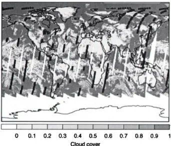
0 0.1 0.2 0.3 0.4 0.5 0.6 0.7 0.8 0.9 1
Cloud cover
Figure 1. Cloud cover, expressed as the fraction of the POLDER super-pixel occupied by clouds, measured on June 16th, 1997. The black bars correspond to the IMG measurements dur- ing the same day.
and clouds" products, which provide the cloud cover and its properties as the optical thickness and the apparent and
Rayleigh pressures which indicate the cloud altitude [Parol
et al., 1999]. For technical
reasons,
the results provided for
the cloud properties are their values averaged over a "super- pixel" of 9 by 9 elementary pixels and their standard devi-
ations [Buriez et al., 1997]. The cloud cover is expressed
as
the fraction of the super-pixel affected by clouds. In Fig- ure 1, we present POLDER cloud cover measurements with colocated IMG measurements for June 16th, 1997. In the following, we use all the common IMG-POLDER available data during four days between June 16 and 19, 1997.
To compare the radiative temperatures calculated from the IMG spectra, we worked with skin temperatures ex- tracted from the ECMWF Advanced Operational Analysis Data Sets. This temperature is that of the Earth's sur- face emission. Over ocean, the skin temperature is the sea surface one. It is estimated by the ECMWF model from assimilated data and it presents a standard deviation lower
•5,
cc 0
2000 2050 2100 2150 2200
Wavenumber (crr•')
Figure 2. Four consecutive radiance spectra (W/(cm2cm-•sr)),
in the 2000-2200 cm -• spectral range, recorded by the IMG in- strument over the Pacific Ocean on June 16, 1997. These spectra are compared with the radiance distribution of a gray body (GB) at a temperature of 302.2 K with an emissivity of 0.9788. The POLDER cloud covers corresponding with the IMG spectra are 0.025 (1), 0.255 (2), 0.975 (3), and 1 (4). The three spectral channels used in the selection method are pointed out by three
arrows.
I I 2 1.4 1.6 1.8 2 2.2
CO total column (10 *•8 molecules/cm •)
Figure 3. Initial (top) and cloud-cleared (bottom) CO global distributions (total columns in molecules cm -2) as retrieved from
IM(] data for the period between June 16 and 19, 1997. The colored bars correspond to the CO total column values.
than i K [Reynolds
and Smith, 1994]. Over land, the skin
temperature is calculated by a land surface parameteriza-
tion scheme, included in the ECMWF model, taking into
account the effect of a vegetation or litter layer on top of
the soil [Viterbo et al., 1999]. There is no direct validation
of this temperature by lack of data. A comparison between
the brightness temperatures measured by the TIROS (Tele- vision InfraRed Observation Satellite) Operational Vertical Sounder (TOVS) instrument and those simulated by a ra-
diative transfer code in the same spectral channels from the skin and atmospheric temperatures of the ECMWF anal- yses gives the following results for clear sky conditions: a difference of the order of 10 K during the day and of 3K
during the night [P. Viterbo, private communication].
As
the POLDER measurements are available only during the day, a standard deviation of 10 K for the land skin tempera- tures was considered. We have colocated the ECMWF skin temperatures with the IMG measurements by multi-linear interpolation in time and space.
Method
We have selected three spectral channels between 2000
and 2200 cm -• where we assume
that the atmosphere
is
relatively
transparent:
2133.28,
2143.00,
and 2150.11
cm -•.
HADJI-LAZARO ET AL.: CLOUD DETECTION IN INFRARED SPECTRA 2399
At these wavenumbers, simulations with a line-by-line radia-
tive transfer model (LBLRTM) [Clough and Iacono, 1995]
using different standard atmospheres give maximum values
of transmission higher than 80% for a tropical atmosphere
and higher than 95% for a subarctic winter one. The at- mospheric radiative contribution is neglected at the three spectral channels and the IMG instrument records the radi- ation of the Earth surface considered as a gray body with a e emissivity at a Trad radiative temperature.
From radiances measured at the three selected spectral
channels,
we calculated
T•ad (i=l, 2, and 3), three values
of the radiative surface temperature using the Planck's law.An emissivity
of 0.9788 was set over sea [Wilber et al., 1999],
whereas a mean value of 0.9677 was used over land. The lat- ter value was obtained using the land emissivity values, rang- ing from 0.8353 to 1 according to the surface type, weighted
by the soil occurrence
provided
by Wilber et al. [1999]. The
estimated
uncertainty
on the T•a radiative temperatures
associated with the uncertainty on the emissivity value is 0.7 and 1.2 K for cases over sea and land, respectively.The calculated
T•a temperatures
are compared
with the
skin temperature extracted from the ECMWF analyses. We
introduce A• (i=l, 2, and 3) the differences between the Ts
ECMWF skin temperature
and the T•a radiative
tempera-
tures as A• = Ts- T•a such
that considering
the ECMWF
and radiative temperatures as independent variables, their uncertainties result in A• uncertainties of 1.3 and 10.1 K for cases over sea and land, respectively.
Figure 2 shows four IMG spectra between 2000 and
2200 cm
-t compared
with the radiance distribution
of a
gray body with an emissivity of 0.9788 at a temperature of 302.2 K, the ECMWF skin temperature colocated with the IMG spectra. The POLDER cloud fractions corresponding to these spectra are 0.025, 0.255, 0.975, and 1, respectively. In this example, we see that the more the cloud cover in- creases the more the spectrum deviates from the gray body radiance distribution. The three arrows point out the three spectral channels used for this study.
To select clear spectra, we determine thresholds on the A• differences above which corresponding spectra are consid- ered as perturbed and the atmosphere as cloudy. In the set of common IMG-POLDER data for cloud covers between 0
and 0.1 (at most 10% of the POLDER super-pixel are cloudy and the IMG pixel has a low probability to be cloudy), the
maxima of A• values are 6.7 and 5.2 K for sea and land cases respectively. By adding to these maxima the uncertainty on the A• differences, we define the final threshold values: 8 K for sea cases and 15.3 K for land cases.
Results and discussion
Efficiency of the clond detection
The selection method was applied to the IMG data for
the period between June 16 and 19, 1997 (6198 spectra). For
each day, about 60% of the IMG spectra are considered as clear. Among them, we find obviously all the daytime IMG measurements associated with POLDER cloud covers lower than 0.1, and about 94, 75.5, 55 and 24% of the daytime IMG data for cloud covers between 0.1 and 0.5, 0.5 and 0.7, 0.7 and 0.9, and higher than 0.9 respectively.
A detailed study was undertaken on the cases associated with POLDER cloud covers between 0.1 and 1 considered as clear by the selection, knowing that the size difference be-
tween the IMG pixel (8 by 8 km) and the POLDER super- pixel (-• 50 by 50 km at the equator) may result in ambigu-
ities. If a POLDER super-pixel is partly cloudy, we have no information on the cloud cover in the associated IMG pixels. For cloud covers higher than 0.1, the situations considered as clear by the selection are those where the IMG infrared spec- trum is not significantly affected by the presence of clouds, and hence a cloud detected by the POLDER operational al- gorithm is not detected by our cloud filter method. All these cases were identified as either low altitude or thin clouds in the POLDER data.
When clouds are close to the Earth surface, the difference between the cloud top and skin temperatures could be of the order of the uncertainty of the skin temperature taken into account in the thresholds of our filter method. Clouds with low associated optical thickness are too transparent to perturb significantly the radiation recorded by the IMG instrument. Because of the size difference between the IMG pixel and the POLDER super-pixel, for some super-pixels
presenting high standard deviations for the apparent and/or Rayleigh pressures and/or the optical thickness, the IMG pixel can also be situated in an area of clouds thin and/or
low enough not to be detected by the IMG spectra selection
method.
The rates of IMG spectra considered as clear by our selec- tion method are in good agreement with those obtained from the POLDER data, taking into account that the POLDER algorithm aims to detect any cloud when our filter allows low or thin clouds which hardly affect the IMG measurements and hence the CO retrieval.
Improvement
of the CO total column retrieval
To show the efficiency of the method described in this paper, we compare in Figure 3 the CO global distributions retrieved before and after the cloud filtering of the IMG data available for the period between June 16 and 19, 1997. The CO total columns are provided by an inversion algorithm
based
on the neural network techniques
[Hadji-Lazaro
et al.,
1999].
The first map shows the CO total columns retrieved from the whole of the IMG data for the four days. The missing data are due to a preliminary selection of the spectra oper-
ated by the IMG Data and Information System (IMGDIS) to
remove those associated with troubles during instrumental calibration. We find in the retrieved CO global distribution main known features: higher columns in the Northern Hemi- sphere polluted regions and over biomass burning regions, lower values in oceanic regions of the Southern Hemisphere. However, unexpected high CO total columns are observed in areas where concentrations are commonly low.
In the second map, we present the global distribution of CO total column retrieved after cloud filtering for the same
period. The spectra selection has cleaned the CO global
distribution by eliminating the anomalies. We checked that the threshold values are fitted correctly to remove cases which damage the quality of the CO total column retrieval. The results are satisfying and the cloud-cleared distribution can then be assimilated in a three-dimensional chemical- transport model to study the budget of the carbon monox-
ide at the global scale [Clerbaux
et al., 2000]. The selection
method is easy to adapt to another spectral range, to re- trieve ozone concentration from IMG data for example.
2400 HADJI-LAZARO ET AL.: CLOUD DETECTION IN INFRARED SPECTRA
Acknowledgments. We thank M. Thetis for assistance in the initial stages of this work. We thank the ECMWF for providing the skin temperature data and especially P. Viterbo for helpful discussions. We also acknowledge the support of the IPSL's P61e donn•es for extracting the data. The au- thors thank IMGDIS/ERSDAC for providing the IMG data. Some of the results presented in this paper were obtained us- ing data from CNES/POLDER onboard NASDA/ADEOS and operational processings performed by CNES. J. Hadji-Lazaro ac- knowledges CNES for the financial support for the present study.
References
Amato, U., V. Cuomo, I. De Feis, F. Romano, C. Serio, and H. Kobayashi, Inverting for geophysical parameters from IMG radiances, IEEE Trans. Geosci. Remote $ens., 37, 1620-1632, 1999.
Buriez, J. C., C. Vanbauce, F. Parol, P. Goloub, M. Herman, B. Bonnel, Y. Fouquart, P. Couvert, and G. S•ze, Cloud detec- tion and derivation of cloud properties from POLDER, Int. J. Remote $ens., 18, 2785-2813, 1997.
Clerbaux, C., P. Chazette, J. Hadji-Lazaro, G. M•gie, J.-F. Miiller, and S. A. Clough, Remote sensing of CO, CH4, and 03 using a spaceborne nadir-viewing interferometer, J. Geophys. Res., 103, 18,999-19,013, 1998.
Clerbaux, C., J. Hadji-Lazaro, S. Payan, C. Camy-Peyret, and G. M•gie, Retrieval of CO columns from IMG/ADEOS spectra, IEEE Trans. Geosci. Remote $ens., 37, 1657-1661, 1999. Clerbaux, C., J. Hadji-Lazaro, D. Hauglustaine, G. M•gie,
B. Khattatov, and J.-F. Lamarque, Assimilation of car-
bon monoxide measured from satellite in a three-dimensional
chemistry-transport model, in press, J. Geophys. Res., 2000. Clough, S. A., and M. J. Iacono, Line-by-line calculation of at-
mospheric fluxes and cooling rates: 2. Application to carbon dioxide, ozone, methane, nitrous oxide and halocarbons, J.
Geophys. Res., 100, 16,519-16,535, 1995.
Deschamps, P.-Y., F.-M. Br•on, M. Leroy, A. Podaire, A. Bricaud, J.-C. Buriez, and G. S•ze, The POLDER mission: In- strument characteristics and scientific objectives, IEEE Trans.
Geosci. Remote $ens., 32, 598-615, 1994.
Hadji-Lazaro, J., C. Clerbaux, and S. Thiria, An inversion algo- rithm using neural networks to retrieve atmospheric CO to- tal columns from high-resolution nadir radiances, J. Geophys. Res., 10•, 23,841-23,854, 1999.
IMG Mission Operation & Verification Committee, Interferomet- ric Monitor for Greenhouse Gases (IMG) Project Technical Report, edited by H. Kobayashi, 45 pp., CRIEPI, Tokyo, 1999. Joiner, J., and L. Rokke, Variational cloud-clearing with TOVS
data, Quart. J. Roy. Meteorol. $oc., 126, 725-748, 2000. Kobayashi, H., A. Shimota, C. Yoshigahara, I. Yoshida, Y. Ue-
hara, and K. Kondo, Satellite-borne high-resolution FTIR for
lower atmosphere sounding and its evaluation, IEEE Trans. Geosci. Remote $ens., 37, 1496-1507, 1999.
Koelemeijer, R. B. A., and P. Stammes, Effects of clouds on ozone column retrieval from GOME UV measurements, J. Geophys. Res., 10•, 8281-8294, 1999.
McMillin, L. M., and C. Dean, Evaluation of a new operational technique for producing clear radiances, J. Appl. Meteorok, 21, 1005-1014, 1982.
Parol, F., J.-C. Buriez, C. Vanbauce, P. Couvert, G. S•ze, P. Goloub, and S. Cheinet, First results of the POLDER "Earth Radiation Budget and Clouds" operational algorithm, IEEE
Trans. Geosci. Remote $ens., 37, 1597-1612, 1999.
Reichle Jr., H. G., et al., Space shuttle based global CO mea- surements during April and October 1994, MAPS instrument, data reduction, and data validation, J. Geophys. Res., 10•, 21,443-21,454, 1999.
Reynolds, R. W., and T. M. Smith, Improved global sea surface temperature analyses using optimum interpolation, J. Clim.,
7, 929-948, 1994.
Serio, C., A.M. Lubrano, F. Romano, and H. Shimoda, Cloud detection over sea surface by use of autocorrelation functions of
upwelling infrared spectra in the 800-900-cm-1 window region,
Appl. Opt., 39, 3565-3572, 2000.
Smith, W. L., X. Lin Ma, S. A. Ackerman, H. E. Revercomb, and R. O. Knuteson, Remote sensing cloud properties from high spectral resolution infrared observations, J. Atmos. $ci., 50, 1708-1720, 1993.
Viterbo, P., A. Beljaars, J.-F. Mahfouf, and J. Teixeira, The rep- resentation of soil moisture freezing and its impact on the sta- ble boundary layer, Quart. J. Roy. Meteorol. $oc., 125, 2401- 2426, 1999.
Wilber, A. C., D. P. Kratz, and S. K. Gupta, Surface emissivity maps for use in satellite retrievals of longwave radiation, Tech. Publ. NASA/TP-1999-œ0936œ, 35 pp., Nat. Aeron. and Space Adm., 1999.
C. Clerbaux and J. Hadji-Lazaro, Service d'A•ronomie, Uni- versit• Paris 6, 4, place Jussieu, BP 102, 75252 Paris Cedex 05, France. (e-maih [email protected])
P. Chazette and P. Couvert, Laboratoire des Sciences du Climat et de l'Environnement, Laboratoire mixte CEA-CNRS, F-91191 Gif-sur-Yvette, France.
C. Boonne, Institut Pierre-Simon Laplace, Universit4 Paris 6, 4, place Jussieu, BP 102, 75252 Paris Cedex 05, France.
(Received September 15, 2000; revised December 4, 2000; accepted December 22, 2000.)
![[PDF] Cours Microprocesseur support complet avec exemples de A a Z | Cours maintenance pc](data:image/gif;base64,R0lGODlhAQABAIAAAP///wAAACH5BAEAAAAALAAAAAABAAEAAAICRAEAOw==)