Building an Equilibrium with the Desert
By
David Craig Rogers
S.B. Massachusetts Institute of Technology
1975
Submitted in Partial Fulfillment of the Requirements for the
Deqree of
Master of Archite'ture at the
MASSACHUSETTS INSTITUTE OF TECHNOLOGY
June 1978
David Craig Rogers 1978
Signature of Author
Certified by
D part knt of Architecture May 12, 1978
Maurice Smith, Prof ssor of Architecture Thesis Supervisor
A)
Accepted by
-Associate Profe or of Architecture Chester Sorague, Chairman Departmental Committee for Graduate Students
MASS§HUSETTS WTITUTE
JUN 2 8 1978
LIBRARIES
MITLibraries
Document Services
Cambridge, MA 02139 Ph: 617.253.2800 Email: [email protected] http://Iibraries.mit.edu/docsDISCLAIMER OF QUALITY
Due to the condition of the original material, there are unavoidable
flaws in this reproduction. We have made every effort possible to
provide you with the best copy available. If you are dissatisfied with
this product and find it unusable, please contact Document Services as
soon as possible.
Thank you.
The images contained in this document are of
the best quality available.
CONTENTS
Abstract CHAPTER 1 CHAPTER 2 CHAPTER 3 CHAPTER 4 oage EXPEDITION 1 ECOLOGICAL CHARACTERISTICS 2.1 - Wind 2.2 - Slope 2.3 - Soil 2.4 - Geology 2.5 - Vegetation 2.6 - Rainfall 2.7 - Runoff 2.8 - Grade 2.9 - Temperature 2.10 - Humidity 2.11 - Evaporation 2.12 - Archaelogv SETTLEMENT PLANNING 3.1 - Buildable Land 3.2 - Arable Land 3.3 - Settlement Size 3.4 - Orientation 3.5 - Form of a Settlement 3.6 - Building Heiaht3.7 - Distance between Buildinas 3.8 - Power
3.9 - Organic Waste Treatment 3.10 - Buildinq Materials 3.11 - The Roof 3.12 - Closure BUILT PRECEDENT 4.1 - Cave 4.2 - Mountain 4.3 - Hill 4.4 - Mesa 4.5 - Canyon 4.6 - Plain 4.7 - Precedent Summary 10 15 19 23 2E 31 34 38 40 44 45 47 53 70 89 91 91 95 97 99 103 105 110 115 123 125 131 137 141 148 163
CHAPTER 5 TWIN COVE BIBLIOGRAPHY LIST OF ILLUSTRATIONS paqe 1 69 1 P2 187
Building an Equilibrium with the Desert David Craig Rogers
Submitted to the Department of Architecture on May 12, 1978 in partial fulfillment of the requirements for the decree of Master of Architecture.
A fundamental reference for buildinq design is the land on which we build. A thorough understanding of the
land is a study in ecological planning. The reference is not an aesthetic of relating built form to nature but it is the equilibrium of naturAl forces.
The more extreme the climate or the more limiting the conditions then the more fragile or vulnerable is the entire ecosystem to disturbance. This is precisely the problem involved with building for man's needs in the drier regions of the Southwest.
The purpose of this thesis is to examine the range of ecological characteristics of this region as a basis
for guiding the design of built environments. The
ecological characteristics include a categorized range of site conditions found in a designated area of south central Arizona.
This information is translated into settlement design decisions through a process of mapping, text and
illustrations. Since settlements have existed and thrived for thousands of years in desert lands similar to this region, a survey of these same design decisions is conducted over a range of topogranhic sites.
In conclusion a settleient is -designed on a sit*
identified as most Appropriate for butlding and ceIttvation with a partial understanding of this desert and the
precedent of millennia.
Thesis Supervisor:
Maurice Smith Professor of Architecture
Emerging from our canvas shroud, dust billows from the upper canopy into the cool motionless air of the morning. The silence is breathless. The dark disintegrates before and above us as streams of color streak across a few wisps of cloud in the deep everpresent blue. The morning air is cool in this valley plain. Gentle downslope night winds have
pooled cool air from the mountain slopes into the valley. In the dim light our tents blend into the landscape as
an
extension of a few small mesquite or remnants of last eveninq's shadow.
This desert is not a windswept barren dune of sand,
Rather it is like eighty percent of desert areas on the
earth, a desert of adequately armed and defensible plants
among stone, gravel, sand and shallow soil.
Rarely is there
a place especially here, north of Phoenix, where the horizon
is not ringed with peaks.
The desert floor is fill or
alluvium washed down from many mountains' mass forming a hard
packed sandy clay for at least 100 feet below the surface.
The landscape like the morning is streaked with
concentrated color of flourishing growth 6long arroyos admist
the evenly separate or clustered creosote bush, cacti and
grass.
This morning at the foot of our climb we have stopped
to study a few for each is an unique balance of conditions
from the specifics of climate to the stone surrounding it.
Sites appear to be chosen where the soil is most suitable,
the roots stretched in all directions to lay claim to the
watershed of the surrounding ground. Most have succulent
stems which store water from their last unrredictable ration.
Leaves are vestigial or completely absent because too much
water would evaporate from them. The stems are green with
chlorophyll to perform the function of leaves and are often
coated with wax. Above, intricate screens cover the entire
stem. Screens which are strong and singular emphasize their
protective function from animals only too glad to use their
succulence. Screens thin
and often dense separate the stem from the hot dissicating air by thick mats of needles providing direct shade to the stem's
surface. We resume our ascent up the progressively steeper and stone strewn terrain.
As we near the edge of a
ridge a silhouette of a saguaro raises its
arms in the fiery ev"y, glow of dawn. First
there is one then a dozen
saguaros appear with green trunked paloverde spread out between. The slope has not changed appreciably, certainly not the altitude and yet these saguaros, giant sentinels towering forty feet over us and weighing up to six tons surround
us. Yet tey are obviously, in
everything except size, quite like most other cacti. The waxy green skin is tender covered by pads of thick needles. It is the ground under our feet which offers the first clue. Though the gravel and stones may look even less hospitable than the sandy clay, rain that falls here soaks into the ground, rather than immediately off it. From the towering height of the saguaro we might expect long roots penetrating many times its height into the ground. But water on this gravel seldom penetrates deep into the parched surface. With a slight slope the water penetrates only eight to twenty
inches, appropriately the depths of the saguaro's roots.
Shallow as they are, they are deep enough to prevent evapora-tion and extend up to ninety feet in radius. Correspondinqly with their basic understanding of water flow their roots on a
slope are predominantly perpendicular to the slope. The saguaro's water system is then fully able to take advantage of the torrential downpours when these roots are bathed in water. A full ton of water may be taken up after a single storm, the accordi on-like pleats of the trunk unfolding as water is absorbed. Carefully in his cistern , the saguaro can easily manage through many months of drought. His
astounding height is not achieved by layering but rather by rigid verticle reinforcement within a flexible mass. The reinforcement, long circular wood rods joined in a cylinder
by a wooden fabric are as long as the saguaro is tall and are
superiority does not go unnoticed. A saguaro often acquires
numerous small caves first excavated by a woodpecker and then
abandoned. I would presume the initial advantage is the
cooling effect of the moist mass within the hole for the
woodpecker before the saguaro heals the wound into a comolete
pocket of hard scar tissue. These abandoned dwellings become
favorite sites for wrens, elf owls and numerous other birds,
dark and sheltered from the sun and heat by the trunks' mass.
Truly the saguaro is an instructive teacher of balance in the
desert.
As our path steepens we follow for a moment a dry arroyo
lined with cottonwood. Away from its edge and up slope we
find ocotillo waving their red tipped fronds.in the wind. Here
at 4500' the saguaros stop as abruptly as they began. The
air becomes cooler now because of altitude, a rise of a
thousand feet verticle being approxiamately equal to travelling
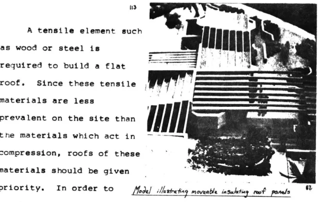
six hundred miles north. The characteristic tree is now the
evergreen oak with yucca and agave in clusters along the around.
Glancing down and over the slopes beneath us a question
occurs to me. Why has no one ever built here? In fact not
just here for between the highlands of Prescott and the valley
plain of Phoenix very little human activity occurs. Why is
that true? The air is cooler here. The rain falls more often
here than in the valley. Compared to the valley vegetation
thrives.
Besides the views over canyons, up mountain slopes,
of the ease with which developement occurs over flat land
rather than on these slopes? Yet, there must be something
more basic which will not allow the throngs of Phoenicians
to extend themselves to this place.
Our chosen climb rises now before us, long slabs of
granite broken ever so discreetly by the cracks which will
allow a route up. Fifteen hundred feet above us we can just
see the outline of Arizona pine, rising at least one hundred
feet to cast thick deep shadows onto a needle carpet floor.
We sit down on a pile of stones to study possible routes.
We discuss the advantage of taking the first pitch along a
ridge rather than in an adjacent crevasse. I am studying the
pile of stones we just sat on.
For it is not just any pile
but a long row of piled stones. We have decided on a route.
Maybe it is the remains of an old stone border wall to
someone's property. We resume walking up the slope to the
base of our climb. Then there is another row of stones and
another not high but quite the same as the fist and
perpendicular to the slope. Maybe someone has built here.
Halfway up the cliff I pause to study a yellow patch
of lichen glistening in the sunlight.
The lichen seems so
insignificant yet it flourishes here on-
this precipice.
Requiring only a hint of moisture the rootless plant
eventually providing the sustenance for the next larger
plant.. The remains of these plants washed away with the
gravel and sand of broken granite become the humus of the
soil, the all important ingredient to allow larger plants
and food to be grown. Turning out to the distance, I
notice the way two parallel arroyos branch to forv
interlocking fingers of cottonwoods with the 'line' of
saguaros. The lazy spiral of a hawk drifting un past me
intercepts my view.
We have joined the spiral ir a Diamant. As we climb, banked into a comfortable thirty deqree turn, paloverde
trees and creosote bushes in the desert below us change from discrete plants to dots in assymetric patterns. We will be explortbg' a region of south central Arizona
encompassing 4500 square kilometers. Soaring between thermals and updrafts we will begin to understand the
movements of the winds, the pattern of air currents determined
by the force-and direction of the wind and the shape of the
obstacles which it encounters. From varying heights of
1,000 to 10,000 feet AGL we will map the delicate topograohy,
soil gradations, vegetation and dry drainage system traceries. Gaining speed and altitude, spriraling at 500 feet per minute, a geometrical transformation alters our perception of the land beneath us. The land is now a texture allowing a broad vision of the changes between the desert and
highlands. Interlacing the transition lie gentle slopes, mesas, steep canyons, bajadas, plateaus and high peaks. To
the south Lake Pleasant formed by the damming of the
floodwaters of the Agua Fria and Calderwood Butte projecting just north of the valley plain of Phoenix. To the east the New River Mountains and Brooklyn Peaks rise high above the mesas and canyons between them. To the west lies the
Bradshaw Hieroglyphic mountains where we may soar a lee wave up to five times the height of the summits above the adjacent valley. With the right wind our airfield is Cordes Junction, to the north.
N) */ SvCa~oU -(' -
00-
/a00, . 7-.0-#- A ow \ 'S N.(
( ~I-7.K. ~
,~%J N~ I ~-- i 'I I -~ r-~ -'.4- --. I' .- ~ 497 K NA'
0Ce S--%
14A .) -w..
mw
s
MAP 1 N. IV N.WIND
2.1
Wind data for Arizona is not especially abundant existing in quanity only for the U.S. Weather Services offices in Winslow, Flagstaff, Prescott, Tucson , Phoenix and Yuma. For this region a wind map has been drawn from experiences gained and related by soaring. The map
indicates the following major wind regions: W - Westerly
B- Bubble
MV - Mountain/Valley winds
MV & C - Mountain/Valley and Canyon winds
The occurence of prevailing westerly winds at this latitude especially towards higher altitudes can be explained by the global coriolis effect. The natural
rotattn of the earth causes an apparent force to be exerted on the atmosphere which deflects the air towards the right
in the northern hemisphere. At 300 north latitude there exists a permanent high pressure area due to the pile up of air caused by the deflection of air moving northward from the equator. Due to this high pressure area the air circulates clockwise around the high producing the prevailing westerlies.
Old sailors knew of the latitudes between 200 and 350 as
dangerous and unpredictable, of frequent calms and erratic winds. They named them the horse latitudes, analogous to the wild tvmperament of a young colt.
mv W. -NW B- wk c giti-~~ MV&C MVe&c w mv
A Bubble or mountain wave is analogous to water runninq over a log in a river. First the water flows up over the
log comparable to the ridge lift over a mountain range. Then it flows down making a trough, then up, and continuing in a diminishing succession of crests and troughs. These
relatively stationary waves are similar to a mountain wave with accompaning updrafts and downdrafts as illustrated below.
"At
4
Prevailing winds can be expected to be East for summer and winter in the lowlands to the south in this region.
For the mountains and mesas the prevailing directions should be to the southwest in the summer and to the southeast in the winter.
Mountain/Valley and Canyon winds can be distinguished by their relative scales of width. Wind direction is greatly
affected by differential heating of the slopes and valleys, high or low land. Usually if no large scale weather
disturbances are present and the winds in the free
atmosphere are light the surface wind will blow upslope during the day. At night downslope or downvalley winds are induced by the rapid radiational cooling of the air overlying the mountain slopes compared to the slow cooling of the air over the valley. Deep narrow canyons can be the windiest as they often increase wind speed by channelling. Normally daytime upslope winds are two to three times stronger than
the night downslope winds. Due to the rugged and widely varying terrain of this region, stagnant winds for extended periods are unlikely.
A-further characteristic of this region and of most
deserts are sandstorms which are quite common in late winter and spring. At a wind speed of 12 mph, sand travels by
boiw* AWI-ly less than four feet off the ground.
Although the prevailing wind directions offer the best clues for the hardest sandblasting in these storms often the fine lucustrine, ancient lake, dust is so thick ,
visibility being less than arm's length that there is no direction from which the sand or dust does not enter.
SLOPE-u
The major incident energy domains are illustrated on map 3. The region was divided into 68 domains corresponding to one of eight compass points as the primary slope orienta-tion. Corresponding to these orientations each slope will recieve differing average amounts of solar insolation. The insolation will vary due to both the inclination of the slope as well as its orientation. Considering the two extremes of east and west slopes, the east slope will recieve insolation from the sun when the temperature is coolest whild the west slopes will recieve the sun when the temperature is already warm. As evident from the following graphs the south
orientations recieve the most insolation from the sun in December, one of the underheated months. During the
over-heated periods, east and west orientations recieve the most insolation. For 320N latitude the insolation in btu/ft2/day:
January 21st June 21st North 150 504 NW&NE 166 924 W&E 604 1152 SW&SE 1236 858 South 1668 444
Sol-air temperature is the temperature of the outside air plus the local heating caused by insolation on a
surface. Using these temperatures and the insolation for varying orientations and a desired temperature range of
S
I
S E SE S225-1
1~~
110..
150. btu/ft275.
6
1n
28
2
2
4
Insolation 320N June 21
from insolation. The west and southwest orientations provide
this insolation in the overheated months when temperatures
are highest, while the east and wotheast orientations provide
insolation in the morning when it is coolest. A southeast
orientation (250 East of South) provides the optimum
orienta-tion. Sites located above the transition zone, on the mesas
or on the mountains would benefit from a slight southerly
shift to 200 East of South.
225.
150.
btu/ft
24
-83
910
11
12
1
2
3
4
I seudia mstrcties
The sky of the desert is usually cloudless and clear. At night it is a deep blue (600 to 650 ft.-lamberts).
Sunrises and sunsets are spectacular and bright, 1,000 to 1,500 ft.-lamberts or more otterr more than twice the brightness of the sky in the temperate zones. This area recieves an average of 80% of the posstble sunlight as
measured by smoothed isolines based on data From black blb type sunshine recorders. Such a constant and dazzling
presence is without equal in importance for understandinq the balance of the desert. Perhaps the construction of a sundial is the first step.
UuirhuitC muilmum
Optimum
Soil is formed by foir major factors - climate, parent rock material, relief and vegetation. Under extreme arid condition one can expect to find soils only in isolated places. On the large scale this would be an oasis or on the small scale beneath an isolated bush. Those soils
existing primarily on steep slopes or extended consolidated rock are called lithosols, where the bedrock is resistant to weathering and carries little to no vegetation.
In the less extreme arid lands of which this region is a part there is frequently an upward movement of soil
moisture creating a leaching of soluble mineral salts such as calcium carbonate (CaCO3) and calcium sulfate. These
soils are known as pedocal illustrated in figure 10 . Often since this soil contains less than 1% organic matter, a hard caliche surface crust of lime and gypsum may appear. Both dry farming and irrigation of the soil are intended to
reverse this leaching process allowinq the mineral nutrients in the soil to become available in a form useable by vegetation.
Refering to the soil map, the following designations have been usedr
B - Basalt, igneous Grumsol from upland plains & mtns. G Granite soil from mountains and foothills
M - Mixed soil, primarily Reddish Brown
DA - Alluvium from valley floors and side slopes, Calcisol
VA - Alluvium from valley plains and slopes, Red Desert - Calcisol
I- W.. f1w Abiw VA - hid her A*iM
a 10 G 0 M DA
cac
Upper
margin
of
CaCO
3tus scrub steppe deci s onifer
-i
t
The Reddish-Brown 1 2' 3 4 5 6
soils are the most pedocal pedalfer
abundant in this
increase in soil moisture region. These soils
1 Sierozems
have a reddish brown to red 2 Brown semi-desert soils
3 Chestnut-brown soils
surface color and an even 4 Chernozems
5 Grey-Brown Podzolic soil
consistency. These soils 6 Podsols it
which have high inherent fertility appear under short grass vegetation at elevations above the lower valleys.
The Red Desert- Calcisol soils occurinq in the southern portions of the site have a surface color which ranges from
light pinki sh-gray to reddish brown or red. The upper sub-.soil often is a deeper red than the surface and is compact. T'he rower subsoil is pink to light gray, rich in lime and mineral nutrients. When irrigated these soils are highlv productive.
Igneous soil in this region is known as Grumsol.
Grumsols are reddish-brown or brown clay soils weathered on volcanic rocks. These soils are fertile, containing few .
of clay of the expanding lattice type. During the dry season, the soil shrinks severely and then upon wetting during the rainy season, July and August or late winter, they swell. These soils also have the unique property of churning to depths of twenty to forty-eight inches. After a rain, water first fills the cracks in the soil causing lateral expansion to occur in the vicinity of the crack
and ultimately forcing the surface soil down Into the crack, the churning motion.
GEOLOGY
The soil and rock fragments covering the earth's
surface are its rug or regolith. In regions of consistent rainfall this reqolith is concurrently consistent with a fine texture of curved hills fashioned by downslope motions of creeping clay. In the desert ti-is cont-inuity does not exist. Here the regolith is thin and coarse causing the slopes to occur in a consistently coarse texture. The
slope angles are steep because the forces requirel to move larger particles are greater.
Even in deserts the most geologic work is done by water and not by wind. Even though most atreams disappear soon after they originate by evaporation, the typical violent storms accompanied by flash floods will move heavy loads of sediment suddenly and quickly. In the flood the
side-slopes are undercut causing steep ridges between side-slopes and a flat alluvium floor. The result is a steep sided box canyon.
The desert lands are sculptel 'uite differently from lands with more rainfall. Mountain slopes in an arid land continually erode a slope or rocky pediment which builds up between alluvial fans. This pediment is eventually the successor of the mountain by uneven periods of erosion
by dissecting branches of arroyo. Wind, the force most effective and prevalent in shaping the intricacies of desert sands, has much less of a contribution to shaping
this region. Only when the mountains have submerged will the winds prevail.
<I)min 11 -i/
The divisions of the geologic map include:
F - Flood plains and low terraces
A2 - Terraces and Alluvial Fans Al - Folded Gravels
Va - Faulted Volcanic Rocks, Basaltic flows, Tuffs and interbedded alluvium
G - Granitic and other crystalline rocks, locally including red rhyolite
M - Metamorphic Rocks, including shist, gneiss and greenstone
I All F -floodpain A2-Wgnau, MAuWi lM Al - m * b -Vadeaul I - Iu~k v- samphkc 0 Vs a vs, G
VEGETATION
2.5Aridity mummifies a landscape by slowinq down the rates of change just as the dry sand and dessicating air preserved the Egyptians and Peruvians for thousands of years. After two or three years a saguaro seedling is only a few milli-meters high and after ten not even an inch. Similarly the communities of this region are comprised of those relatively few plants and animals which have adjusted physiologically to the harsh environment. To disturb any part of this
environment, to remove even one of the dominant species can throw the entire plant and animal community out of balance and destroy its relative stability.for unusually extended periods.
The environment can be characterized by as many variables as are measureable, each variable complicating the analysis of its effect. Frequently temperature and moisture are chosen to evaluate the response of vegetation
to gradients of these factors. However it is evident that a study of a mountain down its slope will show increases in temperature, decreasing moisture, finer soil texture as well as a change in wind, humidity and exposure.
Since greater topographical diversity creates greater diversity in microenvironments it is expected that the diverse transition zone will contain a more complex pattern of
vegetation than either the lower desert, bAsin andl range or upper mesas, the mesa-canyon complex.
DISTRIBUTION OF PLANTS DUE TO qLOPE,
EXPOSURE AND COLD AIR DRAINAGE
N
S
- - -3000'
2800'
2500' 'Canyon Effect'
The Canyon Effect is an Saguaro illustration of the diversity Jojoba created by local topography. Scrub Oak At 2800 feet similiar soil Cottonwood characteristics, slope angle and Grass
rainfall will proddce quite different vegetation depending on orientation. North facing slopes retain more water and
are cooler than south slopes primarily because of insolation. Species such as jojoba, false paloverde or octotillo which are typical of higher altitudes will occur on the north
slopes while species of lower elevations, saguaro, paloverde and bursage will grow on south slopes. Due to the displacement of warmer air upslope, the collection of runoff and i-ncreased shade allow distinctly riparian species, like cottonwood and
scrub oak, usually growing at elevations above 4500 feet are found at the canyon bottoms. The saguaro's upper limit is reached where freezing temperatures throughout a 24 hour period occur.
LAND FORM5 4 8ASW- AVO-RAN6, V96GETAroW
The lower limit occurs SoN coUWIoWS PROFI.E YPES from the decrease in e
moisture occuring when a,...uysLaw
silt and clay increase
A446.4in proportion to rock -
-and gravel.
The Vegetation map A.s, TL...
Map 6, is divided into
5 categories:
o
- Desert Scrub 6a &y Y - Grassland J-* d'-B - WoodlandP - Chaparral & Le i. .
Mountain Brush S.2 F ,.A* A. .
G
-Coniferous Forest
%g-u %-1 -. 8 -s ywr,+ Q'.. U4 44r.
Desert Scrub, creosote
XH. b.ife. 1C+ c.. A
bush, bursage, acacia, occur in sandy and fine
jr4.,CQ-# C"i textured soil often with
caliche. Chaparral & . , .
Mountain Brush - palo - ---- # . +
verde, cactus - occur in 5,--.. 4w I coarse textured gravel or -m 9 6 'efttt
MAP I
IS-Deset krub T- - sIP-
Chspara I- Ceam foFrestN
p Q Yrock. Woodlands occunr from oc-ally modt fied water
availability. These include varyina densities of
Populus, Salix, Froxinus (broad leaf decidous trees) and in drier washes at higher elevations: Prosopis, Aciacia, Chilopsis (narrow leaf trees). The Coniferous Forest is primarily composed of Arizona pine, similar to
the more widely known ponderosa pine, at elevations above
6500 feet.
A study conducted by a group of botanists in this region reinforces the expectation of diversity in the transition zone with the followinq data:
Subshrubs shrubs Succulents Basin&Range Desert Scrub 16 22 18
Transition 51 29 19
Mesa-Canyon Grassland IF 5 5
71, ih
RAINFALL
2JThe distinction of desert is due to rainfAll. The range is usually stated as less than fifteen inches but more accurately when the total evapor-tion exceeds
precipitation. Most deserts occur in the high oressure latitudes from 25 to 30 degrees. Extension of deserts from these latitudes is due to the shape of the land. Mountain ranges force moist air to rise and condense
thereby shadowinq the leeward side. The strong
north-south 'xtension of the Sonoran Desert exist-s because of this action, the moist mir from the Pacific which rises
before the coast range of California shadows the land to
the east.
Four main factors favor precipitation: moisture, mountainous terrain,
convergence or air flow from
s
raaeffmn n face the south and thermal heating,
The existence of moisture is not enough. There must alwavs
exist some mechanism mechanic
-or dynamic to cause air to ri
and cool sufficiently for --
-condensation and cloud formati
to_____- cur. --A--- -- 17
32
20
continental range blocks rainfall to the east so precipitation is usually heaviest on windward slopes of mountain ranges
(west of the Brooklyn Peaks). The nature and intensity of precipitation depends a great deal on the temperature
difference between the earth's surface and the risina air. When the ground is hotter than the overlying air a thermal of rising air occurs which peaks with a cloud formation. This thermal convection combined often with general air mass convergence or intense upslope flow is associated most often with showers or thunderstorms.
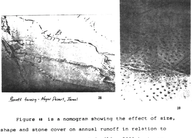
When rain falls on the desert most of it eventually is evaporated into the atmosphere. On the average usually ten percent first percolates in to the soil, usually from five to twenty inches in depth. Twenty percent wets the surface of the ground and twenty percent evaporates almost immediately. The remaining fifty percent leaves the area as runoff.
Factors which bear on the extremelv variable rates of water movement after rainfall include: rainfall intensity and
duration; magnitude and velocity of streamflow; point of entry into the groundwater reservoir, including the hydraulic
1000
+
100
-This graph is a comparison of the basins identified in the region. Evaluation of these
fifteen basrins exhibits a range cf rurroff as a percentage of estimated precipitation varying from 4.3% to 249.4%. In the table following which summarizes data of the basins, the area is in
square milesi the eleva" tion for highest and
e6
'7
11. ,12
e13.15
14. 009
e510
.2
93
al"
* ITO
Area in Square Miles is
Drainage Basins 1. Bishop Creek 2. Tank Creek 3. Lousy Canyon 4. Larry Creek 5. Soap Creek 6. Unnamed Wash 7. Daisy Mountain A 8. Daisy Mountain B 9. Daisy Mountain C 10. Cline Creek 11. Daisy Mountain E
12. Wild Burro Mesa - North Basin
'13. Wild Burro Mesa - South Basin 14. Coles Wash
15. Unnamed wash, SW of 14 houtihof & basinj the type is the type of drainage:
D-dendritic, T-trellis, P-parallel, first given is dominant; the runoff is in acre-feet per year; Ppt. is estimated mean annual precipitation in inches per year; and % is the runoff as a percentage of estimated precipitation.
MAPt 40 I, pf
f
I
12Area 45.6 14.3 8.6 9.0 4.8 Ele. Type Basin
1
.3 3500 2575 2 3 4 5 6 7 8 3000 2190 3480 2140 4250 2310 4690 2230 .7 3320 2245 2857 1720 2997 1690 2030 1567 1930 1967 D D D D 6814 3200 4840 2780 4042 2400 4055 2260 5450 2000 D P,D P,D D D D D T P P,D Runoff 2098 1205 1575 Ppt. % 20 4.3 18 11.4 16 653 656 626 1145 528 494 1649 506 737 2120 822 1064 17 7.9 17 15.0 16 249.4 1F 129.3 16 46.8 16 18.8 16 30.2 16 83.7 14 89.9 14 102.9 12 37.5 12 82.7 20 T,D 1.0 1.3 3.1 6.4 9 10 11 12 13 14 15 1.1 2.7 3.4 2.0GRADE
2.3
Percent grade for this reqion was mappel in five divisions:
5 - 60% slope and greater
4 - 30%- 60% slope 3 - 10%- 30% slope 2 - 5% - 10% slope
1
- Flat to 5% slopeTo determine the relative slope, distance was measured between contour lines from a U.S.G.S. Topographic map. The
relative continuities of these distances within an area
allowed the site to be divided into fifty-one domains of the five slope ranges.
10%-3 1-tas-us 3 I 4 4 6 4 5
6'
Ic2
TEMPERATURE
2.
The distributions of average maximum daily temperatures for January and July are shown on map 10. The dashed line is for January and the sdid line is for July. Note how the
isotherm lines progressively follow the path of the Agua Fria valley. The temperature of still air can be exnected to drop an average of 3.5 degrees Farenheit (or 20C) for
each thousand feet of verticle ascent. This is due to the fact that the temperature of the air is primarily regulated
by the surface of the Earth. Only 15 percent of the incoming
solar radiation is
absorbed by the
-atmosphere. Eighty .-
-five percent of the atmospheric heating
is caused by heating de
of the earth's surface below.
Note the wide range in temperature
between the average maximums and fer. minimums for Jan. OF
regions the diurnal temperature difference is high between
32 to 36 degrees in winter and 36 to 42 deqrees in summer.
In the winter the minimum difference occurs on the mesas while the maximum occurs in the valley plain. In the summer the maximum still occurs in the valley while the minimum occurs in the mountains.
At climatological stations all located above 1,000 feet elevation on slopes overlooking valleys it has been recorded that early morning temperatures in winter may be five to ten degrees higher than those recorded at nearby towns several hundred feet higher or lower. Due to their position on the slope they avoid the relatively cold air which drains off the mountains at night and yet are not high enough to be influenced by the normal decrease in temperature with increased elevation.
HUMiDITY
u.
Annual Variation of mean Relative Humidity, Central Arizoa
80
701
6050
40 6 P.M.30
JF
M
A
M
J
J
A
S
0
N
D
23Relative humidity, usually expressed as a percentage is a function of moisture content and temperture of the air. If the moisture content is constant the relative humidity decreases as temperature rises. Therefore during a typical day the relative humidity will be at a maximum at sunrise and a minimum during early afternoon. In hot weather personal comfort increases with a decreasing relative
humidity. To judge the combined effects of temperature and relative humidity, which usually change in opposite
directions, the U.S. Weather Service has devised a
temperature-humidity index (originally called the discomfort index):
Temp.-Humidity index = .4 (Tair+ Twet- bulb) + 15oF
According to data of the Weather Service , most people feel uncomfortable when the index exceeds 79. Values above 86 are considered extreme.
Using the graph of relative humidity, map 10 - maximum daily temperatures and a psychometric chart to determine wet bulb temperature, the temperature-humidity index for
July can be determined:
RH
Dgy.
bal
Wet bulb
July
6am
55%
60
0F
57.5OF
Temp-humidity index
=
59.6
6pm
45%
102
0F
83
Temp-humidity index
=
89
EVAPORATION
2.u
In 1915 the U.S. Weather Bureau established a network
of stations around the country to measure the evaportion
of water from what is known as the class A land pan. A land
pan is 4 feet in diameter, 10 inches deep and is placed on
a spaced timber platform so that the bottom of the pan is
six inches above ground. A 3-cup totalizinq anemometer
with cups 2 feet above the groind is normally mouftted on the
supports of the pan.
Monthly evaporation from Bartlett Dam located just east
of the study area a 33
049'N is a good indication of the
evaporation from an open canal or cistern near the diameter
of the pan or if a large open storage such as Lake Pleasant
is estimated# reduce the land pan by 30 to 40 percent.
Average Evaporation in Inches, Bartlett
J
F
M..
A
M
J
.J
A
S
0
N
D
4.0
5.3
7.8 10.3
14.6 16.2 16.2 13.2 12.1
10. 5.7
4.5
Water Balance
----.--rainfall, inches
pot. evapotranspiration
- - actual
- -water deficiency
agxw water surplus 1
The effect of wind spin4 en evaporation is very noticeable. When a land pan at Davi Dam (in northern Arizona) was moved 1.5 milei north, up 129 feet to an exposed location where the wind speed was 250% greater the
evaporation increased bv 60%.
Potential evapotranspiration is defined
as the total amount of water lost from the
soil surface and through the stomata of
plant leaves. This transpiration is effected
by temperature, relative humidity, net
radiation ant wi.nd velocity. A climatic
water balance constructed using this data consists of a comparison of potential and actual evapotranspiration with precipitation usually on a monthly basis. The water surplu of Boston compared to the continual deficlinc of water in the Arizona cities gives a visual description of the arid climate.
s
"e
Phoenix, AZ.
Winslow, AZ. Tucson, AZ. Boston, MA. 24ARCHAELOGY2.12
From a recent study by a group of archaelogists this region was last inhabited by a self-sustaining population approxiamately six hundred years ago. Further, a population had continually inhabited this region for one thousand four hundred years previous to that time. The following symbols represent the farming-methods used on areas of this site.
- Flood Plain Linear Borders - Terraces 0 - Cleared Land
C
- Check Dam -ffle GardensFeilds located in areas which are periodically flooded provides crops planted in such fields more water than would normally be recieved from rainfall and sheet flood alone. These fields were identified as flood plains by structure on aijacent areas, sherd or lithic (pottery) concentrations and the presence of petrogyphs on boulders.
The rows of piled rock which we happened to walk across enroute to our climb (pg. o ) were probably at one time
agricultural terraces. Terraces are masonry walls or piled ±ines of rock located on and laying perpendicular to, a slope. The terraces serve the function of collecting and/or retaining soil in an attempt to create flat areas on a given slope
which could then be used for farming. Terraces in this area are generally located on a slooe of 30% with a range from 5%
IEy ** Flood Plat. Liner Swders Terraces Cleared Land CheL ha Waffle ardes .1 .'
/
NJ N-.OW.
(
'/~ ~/~/
K'(
-. ~ .7t'
(~AI)
(
'I)
/
*1
S
2
(.
(.
~)I
b) ,' _to 40%. The walls are generally constructed of unshaped boulders piled three to four courses high and average 20 meters in length. Terrace groups ranged from four to eighty-five separate walls.
Linear borders appear similar to terraces in
appearance and structure but are functionally different. These walls are laid on an angle of perpendicular to the slope in an effort to prevent erosion and to redirect the flow of water.
Cleared land is identified by having had stones and boulders removed from them presumably to create open areas suitable for farming. Only areas with secondary evidence similar to that found at the floodplain sites were recorded.
Check dams are a type of terrace wall used in arroyos to slow or defer the direction of water flow out of the stream or to a backfill behind the dam which causes the stream to overflow its banks into surrounding fields.
Hundreds of acres of waffle gardens were identified in the lower Agua Fria area. These are series of contiguous square borders of rocks on relatively flat gravel terrace of the Agua Fria. The system employs exclusive dry farming
as their location is neither conducive to irrigation or watershed collection.
Accompanying the data of farming systems was the
distance, and orientation to both the nearest water supply and the previous site of dwellings. In general for the
mesa top region, a farming plot was located a short distance to the north or south of an arroyo, the water supply.
Dwellings were to the east of a farming plot or to the
south of the water supply corresponding to either flat land or the south slope. A diagram of t-his general site planning
and the complete list of data for the mesa top follows.
(distances and direction to fields) Dimensions
Slope(%)
Dwellings(#) WaterNSxEW 50X20 2 12 - SE 300m S 200m 64x4 2 12 - S 450m S 600m 55x50 4 11 - S 600m 45x25 4 14 - SE 700m 64x32 2 37 - N 800m N 750m 30x25 2 N 700m 2 10 - S 300m 8 60 - S 1.8km W 20m 55x45 4 50 - W 750m N 100m 62x30 2 12 - NW 1.1km S 200m
Rims & Bottoms
Dimensions
Slope(X)
(distance and
DwelItngs(
)
direction to fields)
Water
NSxEW 20 50 12- E 600m 50-NW 800m 30- N 400m 12-72 37 12- W 650m 10- E 700m 50- N 100m 72-SE 420m 12- N 280m 37- E 330m 18- E 1.4km 20- E 1.1km 60-14- W 500m 12- E 80m 12- E 1km 2O Fr-sl
B7y'gil
Orio&mi.1
- .3a////kt*' 57921 60x70 70x45 120x150 20x20 43x96 35x96 3x42 30x25 13x48 35x25 22x38 10x30 100x300 19x34 10x3 25x8 40 20 5 30 40 2 4 20 2 30 8 2 6 2 3 15 30 8 2 2 S 300m S 800m
S' 200m
N 350m N 25m S 300m N 200m N 1OOm S 100m N 50m S 50m N 50m S 25m S 10m N 25m N 450m E 1OOm S 300m S 300m S 200m&
I? Bishop Creek Lousy Canyon ** Larry Canyon 3, wBUILDABLE
LAND3
When the initial planning of a new settlement or a single building takes place, the land which is possible to be built upon is NEVER the equivalent of a blank peice of paper ready for the free wheeling fantasies of a designer. Rather it is a reality of specifics exposed for a very long period to the effects ofa multitude of modifying factors. Present and seldom accounted for is a product of geological, climatic, hydrological and precedential forces to assist in recoanition of a balanced response in design.
To determine the land of this region which is most suitable for building, each ecological characteristic thus far described will be evaluated and given a priority.
Using these priorities the site will be progressively sieved through overlays of selected ecological characteristic maps. Even though the priorities determine the progressive range of
possible buildable sites the final areas determined would be the same regardless of priority. It is the selection of determinants within the ecolooical characteristics which ultimately identify buildable sites.
The following determinants of the ecolorical characteristics are described in order of their nriority for identifving
1. SLOPE
The first priority selected for settlement planning is slope orientation. The ancient Greek word 'klima' means slope and was defined in order to denote different belts of the surface of the earth which had different-weather conditions due to differences in solar radiation.
A favorable slope orientatation with regArds to the essence
of all climate, the sun, will determine local climatic condition within and without enclosed space. Using the optimum orientations of the angles between the south and southeast for this region,(section 2.2), the slopes of south and southeast will be identified as most appropriate for buildina.
2. WATER
The most prevalent characteristics of settlements in history have been nat-ural defense such as the entrance to a pass and the existence of drinking water. Of least
abundance and greatest need in this region is water. The prehistoric settlements in this area always existed within one mile of a water supply. That limit shall also be the criteria for site selection. The water supply shall include each major drainage basin and its primary network within
3.
SOIL
The Grumsols of this region are the least stable for building. As explained these soils have the unique property of expanding, contracting and churning causing potential havoc to the entire building system. Expansive clay can
exert pressures that exdeed 30,000 pounds per s-3uare foot. It is unlikely that one can resist such pressures with non-yeild construction. The regions of Grumsol will be eliminated as buildable land.
Secondly the skeletal lithosols indicating a thin laver of soil over consolidated bedrock would not be preferred for building sites. However, this soil was not identtfiable as a domain at this scale.
The evaluation of bearing capacity, settlement, drainage, and actual soil content cannot be regionalized. The
necessity for borings and tests to understand the specific ground where building is to occur is not feasible at a larger scale.
4. GRADE
Although grades above thirty percent are appropriate for mountaineers and potential rim guilds, the abundance of
land with grades of thirty percent or less offers conditions of less energy intensity in terms of building and access. Domains of grade thirty percent or less will be selected as buildable.
51 MAP 15 I' ,, 'V I.... I. ~4,w I.
I.
***'~ It~ a, 1~' I, / ~':V
A . .4-'I ~ -* '*. .. * . . ... 1 if b(7
J \m.mm.~I
I'
II
I 'I ~ I I I. 1a
,/.L 'V ** **I* *~ ~ A)
I:..
* I "'I, A%5 ,:~I
-I -* I.. I
5. GEOLOGY
There are two primary methods for measurinq the diggablity of the ground. The first measures the sonic velocity of the earth. In this method a sound impulse is introduced into the ground with the time required for the sound to travel a fixed distance measured. The following table gives a comparison of relative diggability from this method. Velocities below 5,000 feet per second can be easily dug. Those above 5,000 will require blastng.
Air 1,100 feet per second Topsoil 800 2,000 fps Sand 1,500 - 4,000 fps Clay or Soft Shale 3,000 - 7,000 fps Water 5,000 fps Sandstone 5,000 -10,000 fps Limestone 8,000 -18,000 fps Granite 10,000 -20,000 fps
A second method is less applicable to this site due
to the dryness of the soil. Electrical resistance of soil can also measure diggabilitv but it is determined by particle size and moisture content rather than density.
Clay or saturated silt 1 x 10⁴ ohms/cm
Sandy or Silty Clay 2.5
Clayey Sand or Saturated Sand 5.0
Sand 15.
Gravel 50.
Dry Sand or Bedrock Over 500.
Though a large percentage of this region- is comprised of granitic, sedimentary and volcanic rock, its depth
beneath the soil is highly variable and site srecific. Therefore a buildable factor due to diqgability at this scale is not reasonable.
The flow of a river especially the apparently dry
banks of arroyos, dry river beds, which dissect this region are always variable and unpredictable. They are subject to erosion, overflows and flash floods, which can be common after a half hour deluge. The Floodplain is an organic part of the landscape, most frequently shaped and widened
by the topography, qradient and annual discharge of a river
or arroyo. Beyond the total destruction of a building on a floodplain, the construction can be difficult and expensive. Even if in this region the excavation is initially dry, the
foundation will have to watertight and be able to withstand hydrostatic uplift. Floodplains should be designated as non-buildable land.
There are no active faults in this area to particularly consider for earthquake stability however given the
geological information, it is potentially more stable to build on soils with underlying consolidated rock than a less dense clastic rock, gravel, sand, clay or silt in decreasing preference. Further for increased stability, it is less
wise to build across discontinuous strata, illustrated by the dividing lines called faults in a geologic section of the
site. These faults, however, will not be used as buildable criteria in this analysis.
6. VEGETATION
Studies of ecosystems have led ecologists to enumerate certain ecological laws which aid with his ability to
understand and manage our various ecosystems. These laws
can be applied directly to the determination of buildable land within the desert biome. Briefly stated the most apol-icable laws are:
a) Species diversity generally increase in ecosystems when progressing from drier regions to wetter regions
and from colder to warmer regions.
b) Species diversity in an ecosystem tends to produce stability. This implies a species diversity
compatible with the environment.
As established in section 2.5 the transition zone of this region includes the most diverse vegetation. This area will be identified within the intersecting vegetation types as most suitable for building.
The following two criteria are included as the final part of this regional screening process as precedential determinants of buildable land.
7. PREHISTORIC FARMING SYSTEMS
The existence of a previous self-sustaining population within one mile of a site should give a potentially buildable
site a higher priority.
8. OWNERSHIP
This set of information, least ecological was considered to be relevant and necessary information
for the final sites to have a more reasonable possibility for acquisition in some form in order to build. Of the
following divisions of owership only land desiqnated as a national forest, and owned by the National Forest Service should be considered not buildable.
B - State
Y - Bureau of Land Management W - Private or Corporate
G - Forest Service
The following ecological characteristics were determined not suitable for screening buildable sites due to their
relative consistencv within the site. There are however criteria stated which could apply to an ontimum buildlinq
site within the reqion.
A. HUMIDITY
Using the U.S. Weather Service comfort index and the optimum level of 79 (see section 2.10), humidity should fluctuate to allow the sum of dry bulb and wet bulb temperatures to near 160.
Y a V-hm of LOW bmpm V * a kwa I -UkrIe. G Y a
v
B. TEMPERATURE
Klinimum temperatures should remain above freezing for vegetation and plumbing protection. Maximum temperatures
should be nearest the summer comfort range of 70 - 82 degrees F.
C. RAINFALL
A third law established by ecologists states that
productivity generally increases with an increase in available water providing there is sufficient energy to
drive the system. Increased rainfall implies this .increased productivity of a settlement if collection efficiency in
different zones of rainfall is equivalent. Since the natural drainage basins and qradient of slopes which
determine the volume of water available mismatch the areas of greatest rainfall, a criteria using rainfall and this law could be proven inconclusive for this site.
D. EVAPORATION
With the scarcity of water, a minumum of evaporation is obviously desirable. This is accomplished where the natural or built supply or storage is thoroughly protected
from the air,. sun and wind.
E. WIND
would have stagnant wind for extended periods of time. Stagnant wind conditions are to be avoided for both the
lack of natural ventilation and the potential for inversions. Inversions, the lesser consideration, are caused by
temperature increasing with altitude. Since air is a poor conductor of heat an inversion may persist for days or weeks keeping smog, which would be better initially prevented, from leaving an area where it is generated.
ARA3LE
LAND
3.2
Settlements have grown and prospered in arid regions primarily due to their ability to alter the natural
inclinations of water for irrigation of cultivated crops. The most common source of water have been rivers that originated in areas of high rainfall andthen cross arid land enroute to the sea. This water has been most often utilized by direct floodplain farming from overflows of
periodic streamflows or diversion by dams within the stream.
A particularly well developei example of this technique was
performed by the Hohokam on the present site of Phoenix who dug hundreds of miles of canals to utilize the water of the Salt River.
Another major source has been groundwater. Groundwater may originate in natural
aquifers as illustrated in figure 33 at varying depths. This cross section is not of the site but of land in
northeast Arizona. One crucial factor which may account for the lack of
Phoenician expansion into Water level Change
1940-1968 (U.S.G.S.) this site is the lack of
IJ~d rise, less than 10' subsurface water in general drop, less than 10'
IIfllD 10-25'
north of bottom land (fig. is
)
26-75'76-125'
Some bottom land occurs in the more than 125'
32
site adjacent to the Agua Fria and New Rivers accounting for the groundwater obtained at Black Canyon, New River and
Rock Springs (map 1 ). A few innovative techniques for
obtaining groundwater beyond surface depth at a minimum energy level can be seen in the deserts of Algeria and Morocco (figure 34). In central Arizona at the heart of bottom land country where Phoenix rose from the dust to
become the ninth largest desert city in the world, groundwater levels have been dropping at alarming-rates, some more than 125 feet, due to the continuing trend -of - pumping at- a much-higher rat than replenisthment. Certainly if the qround does
I
DI9MOClu obemom'D '41 ISOMEPOST.
kmJu&jS *wow -of
A -- -"*#)ACS 1MLZ PMIWA spppi rjolsI.' OUCATIOIV r, 0-#,6 Qa cow. mMJG4s SMMOO~ EU1TOPA WPrOTOrJE
I
~AA#~SL ~~M4?aoN AIWA60j 7"PPwAII fia IV4 461 *"I
KW..JTA ODAAPbW 4, ., .,. '1 S .4 .. 4....WiOJTA1E SAN PWrOPJ
Loe.-CIN&V FOCMWIOO
IUASbm! CON4&oIgSe
KMMV LINflTOIL
CoCowSIoo GAN OST*@Ne
30UPAI FGCM'ATIO.J 0 33 *IWA%& MW
~
m In d.449 hkA., ~000' foee' -4ooci'-~30d
10*6 -6ir 04) 04 I it-d'I KtdvhkPm.-Vo.,;."PJ %Jail 9INP6
.. ' -- 1-1 1- -l-, V t .-. ."; j.. I uAk4.,
Mzab, Algeria
Well operation - skin
holds
10-13 gallons, pull on cord
releases tirest into channel
not subside due to the
tremerdous pressure differential created the supply will simply run outa In response .to the demand a water canal has been under construction to bring the Cororado River water more than
500 miles in open channels through the desert to Phoenix and Tucson. Despite wishful thinking to the contrary
there is always some limit to which groundwater pumping can occur without depleting the aquifer particularly where
replenishment occurs at a slow r
Lektaoua, Dra Valley Morocco Balance well