HAL Id: cea-02615661
https://hal-cea.archives-ouvertes.fr/cea-02615661
Submitted on 23 May 2020
HAL is a multi-disciplinary open access archive for the deposit and dissemination of sci-entific research documents, whether they are pub-lished or not. The documents may come from teaching and research institutions in France or abroad, or from public or private research centers.
L’archive ouverte pluridisciplinaire HAL, est destinée au dépôt et à la diffusion de documents scientifiques de niveau recherche, publiés ou non, émanant des établissements d’enseignement et de recherche français ou étrangers, des laboratoires publics ou privés.
Tracing the dispersion of sediment contaminated with
radionuclides in catchments exposed to Chernobyl and
Fukushima fallout
O. Evrard, Vladimir Belyaev, Caroline Chartin, Catherine Ottle, Nadezda
Ivanova, Maxim Markelov, Irène Lefevre, Valentin Golosov, Philippe Bonté
To cite this version:
O. Evrard, Vladimir Belyaev, Caroline Chartin, Catherine Ottle, Nadezda Ivanova, et al.. Tracing the dispersion of sediment contaminated with radionuclides in catchments exposed to Chernobyl and Fukushima fallout. Erosion and Sediments Yields in the Changing Environment (Proceedings of a symposium held at the Institute of Mountain Hazards and Environment, CAS-Chengdu, China, 11–15 October 2012), IAHS Publ. 356, 2012. �cea-02615661�
Copyright 2012 IAHS Press
Tracing the dispersion of sediment contaminated with
radionuclides in catchments exposed to Chernobyl and
Fukushima fallout
OLIVIER EVRARD
1, VLADIMIR BELYAEV
2, CAROLINE CHARTIN
1,
CATHERINE OTTLÉ
1, NADEZDA IVANOVA
2, MAXIM MARKELOV
2, IRÈNE
LEFÈVRE
1, VALENTIN GOLOSOV
2& PHILIPPE BONTÉ
11 Laboratoire des Sciences du Climat et de l’Environnement (LSCE/IPSL; CEA-CNRS-UVSQ), Gif-sur-Yvette, France
olivier.evrard@lsce.ipsl.fr
2 Laboratory of Soil Erosion and Fluvial processes, Faculty of Geography, Moscow State University, Moscow, Russia
Abstract The Chernobyl and Fukushima nuclear power plant accidents led to the release of large quantities of radionuclides into the environment. Several of those radionuclides (e.g. 134Cs and 137Cs) strongly sorb
onto soil particles. Once delivered to rivers by erosion processes and runoff, sediment redistribution can lead to the progressive dispersion of radioactive contamination into larger areas over time. This paper deals with case studies conducted in Russia (the 2000 km² River Plava catchment affected by Chernobyl fallout in 1986), and in Japan (the 5000 km² highly contaminated area of Fukushima Prefecture). A key prerequisite for undertaking studies of the subsequent redistribution of contaminated sediment in catchments and river systems is a good knowledge of the initial spatial pattern of soil contamination by fallout radionuclides. In this contribution, we check the local validity of the initial contamination map provided for the Russian case study site and outline the implications for conducting a similar study in Japan.
Key words fallout radionuclides; sediment tracing; nuclear accident; redistribution of contaminated sediment;
catchment; agriculture
INTRODUCTION
The Chernobyl and Fukushima nuclear accidents have both been designated as level 7, the maximum, according to INES (International Nuclear Event Scale). They were characterized by massive emissions of radionuclides into the environment (Masson et al., 2011). After the decay of short-lived radioisotopes (e.g. iodine-131) that can potentially lead to severe human health problems (Robbins & Schneider, 1998), the main environmental concern focuses on the longer-term contamination associated with caesium isotopes (i.e. caesium-134 (134Cs) and caesium-137
(137Cs)). These radionuclides are strongly sorbed by fine soil particles (Wallbrink et al., 1999).
Because of their longer half-life, they constitute a longer-term source of radioactive contamination that can be redistributed within the landscape in association with the mobilization and transport of soil and sediment particles by erosion processes and runoff (Ritchie et al., 1974; Walling et al., 1986; Owens et al., 1997; Sogon et al., 1999). Once delivered to rivers, they can be rapidly redistributed to remote locations (Evrard et al., 2010).
In the literature, many examples can be found of the use of fallout radionuclides as powerful tracers to study sediment mobilization and transfer, and to fingerprint sediment sources (Walling, 2005). However, after nuclear accidents, the fallout radionuclides can themselves constitute a major contamination source and there is a need to trace their redistribution and dispersion to evaluate changes in the magnitude and spatial distribution of contamination through time.
The Chernobyl and Fukushima accidents have several differences. They were characterized by different emission patterns, they occurred under very different weather conditions and they affected contrasting environments. However, a comparative study of the redistribution of radioactive fallout contamination in both regions can provide very important insights into sediment transfer processes.
This paper proposes a methodology for tracing the dispersion of sediment contaminated by fallout radionuclides in different environments and over several timescales. To this end, we will specifically deal with the requirement for a detailed knowledge of the initial pattern of contamination and the main catchment characteristics that need to be taken into account when conducting tracing studies of this type.
Olivier Evrard et al.
2
THE STUDY SITES AND THEIR CHARACTERISTICS
The Chernobyl accident occurred on 26 April 1986 in the Ukraine. Several contamination plumes were emitted after the accident, reflecting the characteristics of the explosion and the weather conditions. One of those plumes moved across the western part of European Russia and resulted in high levels of fallout around the town of Plavsk, which produced the “Plavsk contamination hotspot” (Golosov et al., 1999). Our study site, i.e. the River Plava basin, is located in the vicinity of this hotspot. This river, which has a total length of about 90 km, drains a 1856 km² catchment in the most elevated northern part of the Srednerusskaya Upland (up to 290 m a.s.l.). The mean annual precipitation (1960–2003) in this region, which is characterized by a humid temperate continental climate, is 637 mm. Cropland is the main land use, but the proportion of land devoted to cropping has varied considerably in recent decades. The area of arable land (~80%) reached a peak during the 1970s. This was followed by a large-scale abandonment of arable cultivation after the collapse of the former Soviet Union, primarily during the period 1991–2005. Since then, a partial recultivation of previously abandoned fields has been observed. Information on the sediment budget of the Plava catchment for the period 1986–2009 is provided by Belyaev et al. (2012) (this volume).
The Fukushima accident occurred on 11 March 2011 in Japan. The bulk of the radionuclides emitted were transported offshore and out over the Pacific Ocean (Masson et al., 2011), but change in wind direction and the occurrence of rainfall and snowfall on 14–15 March led to the formation of a major contamination plume to the northwest of the Fukushima Dai-ichi power plant, extending over a distance of 70 km. A large part of this contamination plume was located over the River Abukuma catchment that drains an area of 5200 km² to the Pacific Ocean from an upstream altitude of 1835 m a.s.l. Woodland (79%) and cropland (18%) represent the main land uses in the area. Mean annual precipitation varies appreciably across the study area (1100–2000 mm), in response to the high variation of altitude and relief and the associated variable importance of snowfall.
MATERIALS AND METHODS
In order to trace the redistribution and dispersion of sediment contaminated by fallout radio-nuclides in catchments and river systems, information on the initial pattern of soil contamination from fallout inputs is required. This key information was obtained from different sources for the two study sites. It was based on airborne surveys involving gamma spectrometry measurements. Air dose rates were measured and then converted into radiocaesium inventories (Bq m-2), based on
analysis of representative soil samples in the laboratory. River Plava catchment (Russia)
In Russia, information was available from the Chernobyl contamination atlas produced by Izrael et al. (1998). According to this map, the River Plava flows across a succession of elongated zones characterized by different levels of initial contamination (Fig. 1). The central part of the catchment (in the vicinity of the town of Plavsk) was severely contaminated by 137Cs (>185 kBq m-2),
whereas the southern part of the catchment was much less polluted (<37 kBq m-2).
To check the validity of this map of initial contamination, in situ gamma spectrometry measurements using a field-portable NaI gamma detector were undertaken at reference sites (i.e. experiencing neither soil erosion nor deposition) at various representative locations (n = 87) within the River Plava catchment during the period 23–26 August 2011. To convert these analyses into
137Cs inventories, soil cores were collected (0–30 cm depth) using a metal tube sampler with an
inner diameter of 80 mm at a selection (n = 29) of the sites and analysed by gamma spectrometry using Ge Hyperpure detectors at the Laboratory of Soil Erosion and Fluvial Processes, Moscow State University.
(a) (b)
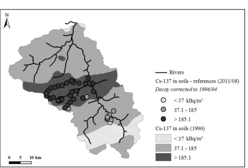
Fig. 1 (a) Location of the study area within European Russia with generalized map of 137Cs
contamination (Izrael et al., 1998). (b) Map of the Plava River basin with initial Chernobyl-derived fallout 137Cs contamination (Izrael et al., 1998) and the location of the study sites. Legend: (1) the
boundary of the River Plava basin; (2) 137Cs baseline fallout reference sampling sites; (3) the key
catchments (1 – the River Lokna; 2 – the Lyapunovka dry valley; 3 – the Sviatoy Istochnik dry valley); (4) the floodplain sampling sites. (5) Levels of the initial 137Cs fallout: <37 kBq m-2; (6) 37–185 kBq m-2;
and (7) >185 kBq m-2.
Fukushima Prefecture (Japan)
In Japan, several airborne survey campaigns were conducted as early as April 2011 under the authority of the Japanese Ministry of Education, Culture, Sports, Science and Technology (MEXT, 2011). Point-based data were taken from the Ministry website and the values were interpolated across the 5000 km² of Fukushima Prefecture potentially affected by high levels of radioactive fallout.
RESULTS
River Plava catchment (Russia)
The correlation between the number of counts measured at 661.7 keV over 300 s using the field-portable detector and 137Cs inventories determined for the corresponding soil cores collected in the
field and subsequently analysed at the laboratory (n = 29), is reasonably good (r² = 0.74; Fig. 2). The precision of the field gamma spectrometry measurements (three replicates) was checked for a set of 19 sites. The mean standard deviation of the field measurements was 8 ± 7%, which must be seen as good for a field-portable detector and given the possible small-scale variation of fallout receipt. The variability only exceeded 10% in potato fields and in forests, where fallout is known to be strongly influenced by the canopy structure (Bunzl et al., 1989). It reached as high as 30% for measurements conducted in potato fields, where contamination was higher between the rows than on the top of the ridges.
The laboratory measured inventories covered a wide range of 137Cs areal activities (18–262
kBq m-2). A power function model (Fig. 3) was used to convert all in situ field measurements (n =
87) into inventories and these values were plotted on the initial contamination map produced by Izrael et al. (1998) (Fig. 4).
Olivier Evrard et al. 4 y = 0.0302x + 1992.6 R² = 0.7421 0 2000 4000 6000 8000 10000 12000 0 50000 100000 150000 200000 250000 300000 N umb er of c ou nt s a t 6 62 k eV Total Cs-137 inventory (Bq/m²)
Fig. 2 The correlation between field and laboratory measurements of 137Cs for the River Plava basin
(August 2011). y = 8.7016x1.1044 R² = 0.8169 0 50000 100000 150000 200000 250000 300000 0 2000 4000 6000 8000 10000 12000 Tot al C s-137 in ve nt ory (Bq /m ²)
Number of counts at 662 keV
Fig. 3 The power function model developed to relate the field measurements of 137Cs activity to the
laboratory measurements of soil inventory undertaken in the River Plava basin (August 2011).
Our measurements, made 25 years after the Chernobyl accident, confirm the overall validity of the map of initial contamination. The estimates of 137Cs inventory obtained for 92% of the
points where gamma spectrometry measurements were undertaken in the field using the portable detector were consistent with the values given for the contamination zones shown on the map produced by Izrael et al. (1998) (see Fig. 4). The location of the River Lokna catchment in the area of highest contamination in the middle part of the River Plava catchment is clearly confirmed by the field measurements. Small discrepancies between the two sources of data can be found close to the boundaries of the zones depicted on the map. These indicate that the boundaries between these zones should not be viewed as clearly defined lines, but rather as transitional areas of up to ~2 km in width.
Fig. 4 A comparison of the point estimates of 137Cs inventory derived from the field measurements
using the model presented in Fig. 3 with the values depicted on the initial contamination map produced by Izrael et al. (1998). The estimates of 137Cs inventory derived from the field measurements have been
corrected for decay to be directly comparable with the data presented by Izrael et al. (1998) which relate to April 1996.
Fukushima Prefecture (Japan)
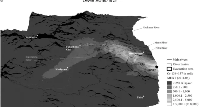
The point-based measurements of 134Cs and 137Cs areal activity density available from the MEXT
database were interpolated across Fukushima Prefecture (Fig. 5). This map shows the presence of a strong contamination plume (>2500 kBq m-2) extending across the coastal mountain range up to
40 km northwest of the Fukushima Dai-ichi power plant, as well as the occurrence of a secondary less pronounced plume (>1000 kBq m-2) in the Abukuma River valley, upstream of Fukushima
City. Forests are mainly located on the steepest hillslopes and close to the summits, whereas cropland (primarily paddy fields) is generally found in the river valleys and on adjacent hillslopes. Potential redistribution of contaminated sediment from the forests remains to be investigated, but it is already obvious that paddy fields will represent one of the major sources of radioactive contamination to the rivers.
CONCLUDING REMARKS
The nuclear accidents that occurred at Chernobyl in 1986 and at Fukushima Dai-ichi in 2011 resulted in the release of large quantities of fallout radionuclides into the environment. Caesium radioisotopes that strongly sorb onto soil particles and that are characterized by relatively long half-lives (2 years for 134Cs and 30 years for 137Cs), compared to the bulk of other fission and
activation products released during this type of accident, constitute a potential threat for contamination of the food chain, and at the same time provide a tracer which can be used to develop an improved understanding of contemporary sediment redistribution and transfer within local catchments. We demonstrated that the use of a field-portable detector to obtain in situ measurements provides a convenient, rapid and reliable method for obtaining quantitative estimates of radiocaesium inventories in soils of contaminated catchments. In this study, we also showed the importance of having good spatially-distributed data to document the initial pattern of fallout contamination which is a key requirement for studies of post-fallout redistribution and dispersion of the radiocaesium. Major differences in climate, topography and land use between the Russian and Japanese catchments can be expected to lead to contrasts in the export and dispersion
Olivier Evrard et al.
6
Fig. 5 The inventories of 134+137Cs in soils across Fukushima Prefecture (Japan) in June 2011
of contaminated sediment by rivers. The steeper slope gradients and the more erosive climate prevailing in Japan is very likely to trigger a massive export of contaminated sediment to lowland rivers and the Pacific Ocean, whereas in Russia the bulk of the sediment mobilized by erosion was found to be stored on the uncultivated lower parts of slopes or in the bottoms of infilled gullies, hollows and 1st–3rd order valleys, and only a limited amount reached partly the larger rivers. Acknowledgements This work was funded by the CNRS (France) and the RFBR (Russia) in the framework of their joint international research programme (CNRS-RFBR project no. 09-05-91057). The research group from Moscow State University has received additional financial support from the RFBR (project no. 10-05-00976), the IAEA (project RUS/15482) and the President of the Russian Federation support programme for young researchers (project no. MK-1221.2012.5) and for leading scientific schools (project no. NS-79.2012.5). The work of the French partners on the Fukushima accident has been initiated and funded in the framework of the TOFU (Tracing the environmental consequences of the Tohoku earthquake-triggered tsunami and Fukushima accident) project, funded by the joint ANR-Flash Japon (ANR- 11-JAPN-001) and JST/J-RAPID programme.
REFERENCES
Belyaev, V., Shamshurina, E., Markelov, M., Golosov, V.,Ivanova, N., Bondarev, V., Paramonova, T., Evrard, O., Lio Soon Shun, N., Ottlé, C., Lefèvre, I. & Bonté, P. (2012) Quantification of the sediment budget of a river basin, based on reconstruction of the post-fallout redistribution of Chernobyl particle-bound 137Cs. In: Erosion and Sediments Yields in the
Changing Environment, IAHS Publ. 356, (this volume).
Bunzl, K., Schimmack, W., Kreutzer, K. & Schierl, R. (1989) Interception and retention of Chernobyl-derived 134Cs, 137Cs and 106Ru in a spruce stand. Science of the Total Environment 78, 77–87.
Evrard, O., Némery, J., Gratiot, N., Duvert, C., Ayrault, S., Lefèvre, I., Poulenard, J., Prat, C., Bonté, P. & Esteves, M. (2010) Sediment dynamics during the rainy season in tropical highland catchments of central Mexico using fallout radionuclides.
Geomorphology 124, 42–54.
Golosov, V. N., Panin, A. V. & Markelov, M. V. (1999) Chernobyl 137Cs redistribution in the small basin of the Lokna River,
Central Russia. Physics & Chemistry of the Earth A 24(10), 881–885.
Masson, O., Baeza, A., Bieringer, J., Brudecki, K., Bucci, S., Cappai, M., Carvalho, F.P., Connan, O., Cosma, C., Dalheimer, A., Didier, D., Depuydt, G., De Geer, L.E., De Vismes, A., Gini, L., Groppi, F., Gudnason, K., Gurriaran, R., Hainz, D., Halldórsson, Ó, Hammond, D., Hanley, O., Holeý, K., Homoki, Zs., Ioannidou, A., Isajenko, K., Jankovic, M., Katzlberger, C., Kettunen, M., Kierepko, R., Kontro, R., Kwakman, P.J.M., Lecomte, M., Leon Vintro, L., Leppänen, A.-P., Lind, B., Lujaniene, G., McGinnity, A.-P., McMahon, C., Malá, H., Manenti, S., Manolopoulou, M., Mattila, A., Mauring, A., Mietelski, J.W., Møller, B., Nielsen, S.P., Nikolic, J., Overwater, R.M.W., Pálsson, S.E., Papastefanou, C.,
Penev, I., Pham, M.K., Povinec, P.P., Ramebäck, H., Reis, M.C., Ringer, W., Rodriguez, A., Rulík, P., Saey, P.R.J., Samsonov, V., Schlosser, C., Sgorbati, G., Silobritiene, B.V., Söderström, C., Sogni, R., Solier, L., Sonck, M., Steinhauser, G., Steinkopff, T., Steinmann, P., Stoulos, S., Sýkora, I., Todorovic, D., Tooloutalaie, N., Tositti, L., Tschiersch, J., Ugron, A., Vagena, E., Vargas, A., Wershofen, H. & Zhukova, O. (2011) Tracking of airborne radionuclides from the damaged Fukushima Dai-ichi nuclear reactors by European networks. Environmental Science &
Technology 45, 7670-7677.
Izrael Yu.A. (ed.) (1998) Atlas of Radionuclide Contamination of European Parts of Russia, Belorussia and the Ukraine. IGKE Rosgidromet, Roskartographiya, Moscow (in Russian).
MEXT (Ministry of Education, Culture, Sports Science and Technology) and US Department of Energy (DOE) (2011) MEXT and DOE Airborne Monitoring. [Available at http://www.mext.go.jp/english/incident/1304796.htm].
Owens, P. N., Walling, D. E., He, Q., Shanahan, J. & Foster, I.D. (1997) The use of Caesium-137 measurements to establish a sediment budget for the Start catchment, Devon, UK. Hydrol. Sci. J. 42, 405– 423.
Ritchie, J. C., McHenry, J. R., Gill, A. C. (1974) Fallout 137Cs in the soils and sediments of three small watersheds. Ecology 55,
887–890.
Robbins, J. & Schneider, A. B. (1998) Radioiodine-induced thyroid cancer: Studies in the aftermath of the accident at Chernobyl. Trends in Endocrinology & Metabolism, 9(3), 87-94.
Sogon, S., Penven, M.-J. & Bonté, P. (1999) Estimation of sediment yield and soil loss using suspended sediment load and 137 Cs measurements on agricultural land, Brie Plateau, France. Hydrobiologia 410, 251–261.
Wallbrink, P. J., Murray, A. S. & Olley, J. M. (1999) Relating suspended sediment to its original soil depth using fallout radionuclides. Soil Sci. Soc. Am. J. 63, 369–378.
Walling, D. E. (2005) Tracing suspended sediment sources in catchments and river systems. Science of the Total Environment 344, 159-184.
Walling, D. E., He, Q. & Quine, T. A. (1996) Use of fallout radionuclide measurements in sediment budget investigations.
Geomorphologie 3, 17– 28.
Yasunari, T. J., Stohl, A., Hayano, R. S, Burkhart, J. F., Eckhardt, S. & Yasunarie, T. (2011) Caesium-137 deposition and contamination of Japanese soils due to the Fukushima nuclear accident. Proc. Natl. Acad. Sci. 108(49), 19530–19534.