2012
Oliver Schönweger
Andreas Heinimann
Michael Epprecht
Juliet Lu
Palikone Thalongsengchanh
Concessions
Lao PDR
and
in the
Leases
Concessions and Leases
in the Lao PDR:
Taking Stock of Land Investments
2012
-Oliver Schönweger,
Andreas Heinimann, Michael Epprecht, Juliet Lu, Palikone Thalongsengchanh
Swiss Agency for Development and Cooperation (SDC)
Concessions and Leases in the Lao PDR: Taking Stock of Land Investments
Under the Supervision of:
Mr. Chanthaviphone Inthavong (Acting Director General, Land and Natural Resources Research and Information Centre (LNRRIC), National Land Management Authority (NLMA) through March 2012), and Mr. Nouphan Mahaphon (Director General, Natural Resources and Environmental Information Centre (NREIC) since March 2012) Data Collection Team:
Vong Nanhthavong, Soukan Latsavong, Vanthong Lattanavilay, Chanthachone Khiemsombath, Maitenh Syphanthip, Phumany Panyanouvong, Chanly Sylakoun, Vithoun Sayvongsa, Lammone Thiengthammavong, Sython Pangpaseuth (Technical Staff at the time of data collection, LNRRIC), Dr. Palikone Thalongsengchanh (Deputy DG of Land and Natural Resources Research and Information Center (LNRRIC), Ministry of Natural Resources and Environment (MoNRE))
Data Analysis/GIS/Statistics:
Juliet Lu (Research Assistant, CDE), Dr. Andreas Heinimann (Senior Research Scientist, CDE), Oliver Schönweger (Researcher, CDE), Chorn Nak (GIS-Specialist, CDE), Dr. Cornelia Hett (Researcher, CDE), Stefan Sylla (CIM, MoNRE), Dr. Michael Epprecht (Senior Research Scientist, CDE)
Editing:
Juliet Lu, Mike Dwyer Design/Layout: Remy Rossi Pictures:
Data collection team, Don Duvall (Cover - picture right, pages 77, 88-89) Supported by:
Swiss Agency for Development and Cooperation (SDC) – Centre for Development and Environment (CDE) - Deutsche Gesellschaft für Internationale Zusammenarbeit (GIZ)
Authors:
Oliver Schönweger, Andreas Heinimann, Michael Epprecht, Juliet Lu, Palikone Thalongsengchanh Cite this document as:
Schönweger O., Heinimann A., Epprecht M., Lu J., Thalongsengchanh P., 2012: Concessions and Leases in the Lao PDR: Taking Stock of Land Investments. Centre for Development and Environment (CDE), University of Bern, Bern and Vientiane: Geographica Bernensia
Centre for Development and Environment (CDE) Ministry of Natural Resources and Environment (MoNRE)
Lane Xang Avenue, Vientiane Capital, Lao PDR Phone: +856 30 9881648
Disclaimer
The data presented and analysed in this publication is based on the State Land Leases and Concessions Inventory Project data. The Centre for Development and Environment (CDE) cleaned the inventory data and combined it with other spatial and socioeconomic datasets. Every reasonable effort was made to ensure that the data presented and analysed within this publication is as accurate and complete as possible. The authors however offer no warranty regard-ing the accuracy, adequacy, legality, reliability or completeness of the data contained in the State Land Leases and Concessions Inventory or other data layers included. The authors will likewise accept no legal liability or responsibility for any errors or omissions in the information.
The views expressed in this publication are those of the authors and do not necessarily reflect those of the CDE, GIZ, MoNRE or any other involved institution or organization.
The boundaries, colours, denominations and any other information shown on the maps in this book do not imply any judgment on the legal status of any territory, or any official endorsement or acceptance of the boundaries on the part of the government of the Lao PDR.
For more information, please contact:
Ministry of Natural Resources and Environment Natural Resources and Environmental Information Center (NREIC)
Chao Anou Road, Thongkhankham Village, Chanthabouly District, Vientiane Capital, Lao PDR Tel: +856 21 911281 or 911624
List of Figures
List of Maps
List of Tables
Acronyms
Preface
Foreword
Acknowledgements
Executive Summary
I.
INTRODUCTION
1.1 - Background of the State Land Leases and Concessions Inventory
1.2 - The “State Land Leases and Concessions Inventory Project”
1.3 - Capitalizing on Inventory Data
II.
RESULTS
2.1 - Inventory Overview
2.2 - Investment in the Primary Sector
2.3 - Investment in the Secondary Sector
2.4 - Investment in the Tertiary Sector
III.
CONTEXT OF INVESTMENT
3.1 - Elevation
3.2 - Accessibility
3.3 - Socioeconomic Patterns
3.4 - Forest Categories
3.5 - Land Cover Classes
IV.
CONCLUSIONS
References
ANNEX - Case Studies
Introduction
Capacity Issues
Regulatory Issues
Investor Obligations and Agreements
2
3
4
5
6
7
8
9
13
14
14
16
19
20
27
47
49
53
54
55
58
67
70
75
79
81
81
81
83
85
Table of Contents
List of Figures
Figure 1: Availability of Area and Spatially Referenced Data Figure 2: Number of Concessions and Leases by Project Size Figure 3: Main Investor Countries of Origin by Region Figure 4: Increase in Investment Projects since 2000
Figure 5: Number and Area of Projects by Subsector in the Primary Sector Figure 6: Average Project Area by Investor Country of Origin and Subsector Figure 7: Main Products by Subsector in the Primary Sector
Figure 8: Area per Region by Subsectors in the Primary Sector
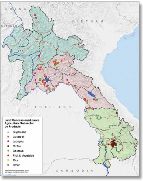
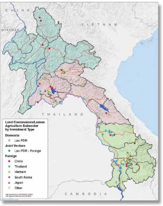
Figure 9: Number and Area of Projects by Main Investor Countries of Origin in the Agriculture Subsector Figure 10: Main Products in the Agriculture Subsector by Region
Figure 11: Number and Area of Projects by Main Products in the Forestry Subsector
Figure 12: Number and Area of Projects by Investor Country of Origin in the Forestry Subsector Figure 13: Main Products in the Forestry Subsector by Investor Country of Origin
Figure 14: Main Investor Countries of Origin in the Forestry Subsector by Region Figure 15: Number and Area of Projects by Main Products in the Mining Subsector Figure 16: Number and Area of Projects in the Mining Subsector by Investor Type Figure 17: Accessibility (by travel time to district capital) of Concessions and Leases
Figure 18: Accessibility (by travel time to district capital) by Subsectors in the Primary Sector Figure 19: Accessibility (by travel time to district capital) by Main Investor Countries of Origin
Figure 20: Poverty Incidence in Areas under Investment and % of Villages with Poverty Incidence Higher (Poorer) than the National Average by Investor Country of Origin
Figure 21: Villages with Poverty Incidence Higher (Poorer) and Lower (Better off) than the National Average by Investor Country of Origin
Figure 22: Literacy Rates in Areas under Investment by Investor Country of Origin Figure 23a: National Forest Management Categories in the Total Area of the Lao PDR Figure 23b: National Forest Management Categories in Areas under Investment Figure 24: Area under Investment in Forest Management Categories by Subsector Figure 25: Area under Investment in Rubber by Forest Management Category
Figure 26: Area under Investment in Forest Management Categories by Main Investor Country of Origin Figure 27a: Area per Land Cover Class in the Lao PDR
Figure 27b: Area per Land Cover Class in Areas under Investment Figure 28: Land Cover Classes in Areas under Investment by Subsector Figure 29: Land Cover Classes by Investor Country of Origin
17
21
26
27
28
28
30
30
32
33
36
38
38
38
40
42
57
57
57
63
64
64
68
68
69
69
69
73
73
73
73
List of Maps
21
24
26
29
32
33
36
39
41
42
44
45
48
51
54
56
60
61
66
68
72
Map 1: Locations of Concessions and Leases across the Lao PDR Map 2: Investment Project Locations and Investor Country of Origin Map 3: Three Main Geographic Regions of the Lao PDR
Map 4: Investment Project Locations by Subsector in the Primary Sector
Map 5: Investment Project Locations and Main Products in the Agriculture Subsector
Map 6: Investment Project Locations and Investor Country of Origin in the Agriculture Subsector Map 7: Investment Project Locations and Main Products in the Forestry Subsector
Map 8: Investment Project Locations and Investor Country of Origin in the Forestry Subsector Map 9: Investment Project Locations and Main Products in the Mining Subsector
Map 10: Investment Project Locations and Investor Country of Origin in the Mining Subsector Map 11: Investment Project Locations in Mining Exploration
Map 12: Investment Project Locations and Main Products in Mining Exploration Map 13: Investment Project Locations by Subsector in the Secondary Sector Map 14: Investment Project Locations by Subsector in the Tertiary Sector
Map 15: Elevation Map, Investment Project Locations and their Average Elevations
Map 16: Accessibility Map (by travel time to district capital), Investment Project Locations and their Average Accessibility
Map 17: Poverty Incidence Map, Investment Project Locations and their Poverty Incidence
Map 18: Poverty Incidence Map, Investment Project Locations and Villages with Poverty Incidences Higher (Poorer) and Lower (Better off) than the National Average
Map 19: Ethno-linguistic Families Map, Investment Project Locations and their Dominant Ethno-linguistic Family Map 20: National Forest Management Categories Map, Investment Project Locations and their Main Forest Management Category
List of Tables
Table 1: Overview of Concessions and Leases
Table 2: Overview of Investment Projects by Sector and Subsector Table 3: Overview of Investment Projects by Investor Type
Table 4: Overview of Investment Projects by Investor Country of Origin Table 5: Overview of Investment Projects by Region
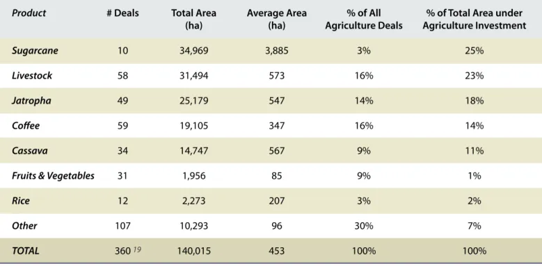
Table 6: Overview of Agriculture Subsector Projects by Product
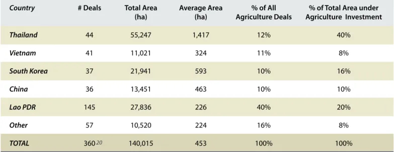
Table 7: Overview of Agriculture Subsector Projects by Investor Country of Origin Table 8: Overview of Forestry Subsector Projects by Product
Table 9: Overview of Forestry Subsector Projects by Investor Country of Origin Table 10: Overview of Mining Subsector Projects by Product
Table 11: Overview of Mining Subsector Projects by Investor Country of Origin Table 12: Overview of Mining Exploration Projects by Product
Table 13: Overview of Mining Exploration Projects by Investor Country of Origin Table 14: Overview of Secondary Sector Projects by Subsector
Table 15: Overview of Secondary Sector Projects by Investor Country of Origin Table 16: Overview of Tertiary Sector Projects by Subsector
Table 17: Overview of Tertiary Sector Projects by Investor Country of Origin Table 18: Elevation of Investment Projects Compared to All Land by Region
Table 19: Villages with Poverty Incidence Higher (Poorer) than the National Average, Nationally and in Areas under Investment
Table 20: Poverty Incidence in Areas under Investment and % of Villages with Poverty Incidence Higher (Poorer) than the National Average
Table 21: Poverty Incidence in Areas under Investment and % of Villages with Poverty Incidence Higher (Poorer) than the National Average by Investor Type
Table 22: Poverty Incidence by Subsector and Investor Type
Table 23: Ethno-linguistic Groups, Nationally and in Areas under Investment Table 24: Land Cover Classes Nationally and in Areas under Investment
20
23
23
25
25
31
34
37
37
43
43
46
47
48
49
49
50
55
59
62
62
63
65
70
Acronyms
BMZ Bundesministerium für wirtschaftliche Zusammenarbeit und Entwicklung (German Federal Ministry for Economic Cooperation and Development) CDE Centre for Development and Environment
DLMA District Land Management Authority
DoF Department of Forestry
DoS Department of Statistics FDI Foreign Direct Investment
FIPD Forest Inventory and Planning Division GIS Geographic Information System
GIZ Deutsche Gesellschaft für Internationale Zusammenarbeit (German International Cooperation)
GoL Government of the Lao PDR
GPS Global Positioning System
JV Joint Venture
LECS III Lao Expenditure and Consumption Survey III
LMRP Lao-German Land Management and Registration Project LPDP Lao-German Land Policy Development Project
MEM Ministry of Energy and Mines
MoNRE Ministry of Natural Resources and Environment MPI Ministry of Planning and Investment
NCCR Swiss National Centre of Competence in Research North-South NLMA National Land Management Authority
NREIC Natural Resources and Environmental Information Centre
NPA National Protected Area
PLMA Provincial Land Management Authority
SDC Swiss Agency for Development and Cooperation SNIS Swiss Network for International Studies
Preface
As part of its aim of supporting economic growth and poverty alleviation, the Government of the Lao PDR (GoL) is seriously committed to the sustainable development of the nation’s rich natural capital and land. In order to achieve the social development objectives identified under the United Nations Millennium Development Goals initiative by the year 2020, increasing national forest cover and revenues from land management have been identified as vital initiatives. Private investment in land, especially through leasing and granting concessions of state land to investors for development, has thus been strongly encouraged by the GoL. While this has brought about a significant increase in investment in land in the Lao PDR, weaknesses in national land planning and the enforcement of investment regulations have generated concerns regarding the implications of such projects for local land tenure security, food security and natural environments, among other issues.
In order to ensure that the recent boom in land-based investment contributes to poverty alleviation and sustainable development, its impacts and trends must be critically examined. A lack of comprehensive and accurate documentation of concessions and leases of state land already granted has inhibited progress in the regulatory arena, as well as the capacity for evidence-based decision making more generally. In response to this, in May 2007, a moratorium on granting land was enacted, and an evaluation of approved projects, their activities and effects initiated. The former National Land Management Authority (NLMA) and the Lao-German Land Management and Registration Project (LMRP) of the Deutsche Gesellschaft für Internationale Zusammenarbeit (GIZ), with funding from the German Federal Ministry for Economic Cooperation and Development (BMZ), carried out an inventory of state land granted for investment. On this basis, with funding received from the Swiss Agency for Development and Cooperation (SDC), the Natural Resource and Environmental Information Centre (NREIC) of the Ministry of Natural Resources and Environment (MoNRE), in cooperation with the Centre for Development and Environment (CDE) of the University of Bern, performed the analysis presented in this book, “Concessions and Leases in the Lao PDR: Taking Stock of Land Investments”.
This publication provides valuable data, informative analysis and critical perspective on the state of land and natural resource development in the Lao PDR. It can thus be considered a form of feedback on government policies, particularly those implemented by MoNRE, as well as a guide for promoting efficient, equitable and sustainable land management in line with Articles 77 and 78 of the Land Law of 2003 (GoL/NA, 2003).
I would like to convey my special thanks to the Swiss Agency for Development and Cooperation (SDC) for funding this publication, the participating teams at both CDE and GIZ, the line ministries, local government organizations and other relevant agencies who have actively provided this project with their support, making this important and invaluable piece of collaborative research and analysis possible.
Dr. Akhom Tounalom
Foreword
The Lao PDR is rich in natural resources, and thus the governance of its land is the backbone of sustainable development, economic growth and poverty eradication. Land and natural resources have attracted significant investment, both foreign and domestic, over the last 10 years, and thus have contributed to generating substantial national revenue. The Lao PDR has thus evolved into a supplier of raw agricultural commodities, tree crops, minerals as well as hydropower, mainly for its large neighbouring economies, leading to a drastic increase of the demand on land.
Due to the lack of reliable or comprehensive data about investment in land, the Government of the Lao PDR (GoL) and the National Assembly felt the need to gain a comprehensive overview of ongoing investment projects and to quantify the extent of land concession and lease areas as the basis for future decision making and policy development. In response, the German Federal Ministry for Economic Cooperation and Development (BMZ) through the Lao-German Land Management and Registration Project (GIZ LMRP) has provided financial support and technical advice to the former National Land Management Authority (NLMA) to collect data for a State Land Leases and Concessions Inventory. This information was compiled in the State Land Lease and Concession Inventory database, out of which provincial reports have been produced. The State Land Leases and Concessions Inventory represents a globally unique and extremely valuable database, especially in the Lao PDR where commercial pressure on land has increased exponentially over the last decade. Until today, all available insights are based on either aggregated official statistics (GoL reporting) or site specific case study information. Hence, there has been no detailed, comprehensive set of information compiled on a national scale describing land concessions and leases. As active as the debate on this topic has been, it has nonetheless suffered from this lack of a national baseline of data.
A vast store of data has now been collected at the local level, and in a spatially explicit manner which allows for relating it to other national level information (e.g. socioeconomic data). This represents the first insight into the contexts (e.g. in relation to poverty, environment and infrastructure) land concessions and leases take place in. Against this backdrop, to make this valuable data available and to generate added value on a national level, the Swiss Agency for Development and Cooperation (SDC) supported the analysis upon which this “Concessions and Leases in the Lao PDR: Taking stock of Land Investments” is based. Consolidation and analysis was carried out in a trilateral way, mainly between the Natural Resource and Environment Information Centre (NREIC) of MoNRE and the Centre for Development and Environment (CDE) of the University of Bern, with significant contributions from the Deutsche Gesellschaft für Internationale Zusammenarbeit (GIZ).
We expect the knowledge and insights provided in this publication to support the Government of Laos in better pursuing evidence-based decision making and sustainable development. Its contents may also point to current and potential negative aspects of land investment, as well as constructive strategies for avoiding or mitigating their effects. Similarly, we expect that a range of national and international agencies active in the field of land management and governance will find great value in this report as a reference and guide to constructive discourse on investment in land in the Lao PDR for the years to come.
Ruth Huber Regional Director
SDC Programme for the Mekong Region
Dr. Petra Mutlu
GIZ Country Director Laos
Deutsche Gesellschaft für Internationale Zusammenarbeit (GIZ) GmbH Lao-German Development Cooperation
D eu ts ch e G esel lsch aft f
ür Internationale Zusamm
en ar be it (G IZ ) G m bH L ao -G erm an Dev elo pm en t C oo pe ra tio n Office Vientiane
The Natural Resources and Environmental Information Centre (NREIC), especially the team under the Division of Training, would like to express their gratitude to the authorities of the former National Land Management Authority (NLMA) and to the newly established Ministry of Natural Resources and Environment (MoNRE) for providing guidance throughout the process of data collection and analysis.
The team would like to thank all participating line ministries for sharing information and for their valuable collaboration. Thanks as well to all organizations that provided additional data and maps during the process of data collection. The efforts of all provincial and district administrative authorities involved are greatly appreciated, including the Provincial and District Land Management Authorities (PLMA, DLMA) and concerned sectors in all provinces that provided support and cooperated with the team. Village authorities and communities were also invaluable contributors to this research. Furthermore, the team is extremely grateful for the support of the technical staff from the Office of Land Information and Mapping of the PLMA and DLMA in all provinces, who contributed actively to the success of data collection.
The team would like to express its gratitude to the Centre for Development and Environment (CDE) and the Swiss Agency for Development and Cooperation (SDC), as well as the Lao-German Land Management and Registration Project (LMRP) of the Deutsche Gesellschaft für Internationale Zusammenarbeit (GIZ) and the German Federal Ministry for Economic Cooperation and Development (BMZ) for providing funding, equipment, and logistical and technical support.
Special thanks to the fruitful exchange between and contributions from the Swiss National Centre for Competence in Research North-South (NCCR) the Swiss Network for International Studies (SNIS), the Land Observatory Project and the Agro-biodiversity Initiative (TABI). Finally, thanks to all international organisations and individual experts, especially to Mike Dwyer who meticulously reviewed this publication, for sharing information and contributing in one way or another to the success of the project.
Acknowledgements
Investment in land is a cross-cutting issue considered integral to socioeconomic change, natural resource management and economic development in the Lao PDR. Expanding demand for raw materials by rapidly growing neighbouring economies (particularly Thailand, Vietnam and China) and the establishment of policies and regulatory frameworks favourable to land- and resource-intensive investment have driven a rapid increase in the area of land granted for development. The number of land deals has skyrocketed in recent years, increasing fifty fold from 2000 to 2009. Still, constructive debate as to the costs, benefits and sustainable alternatives to this shift has remained hampered by a lack of reliable and comprehensive data.
The State Land Leases and Concessions Inventory represents a globally unique and extremely valuable database from various perspectives. It contains the spatially explicit data collected under the former NREIC-GIZ project, and is the first systematic inventory that allows for visualising and analysing the extent and dimensions of land-intensive investment across the entire country. Until now, all available insights into the expansion of land investments in the Lao PDR were based on either aggregated official statistics or site-specific case studies. As a result, no detailed information on land concessions was available on a national level. The data in the inventory was collected locally and in a spatially explicit manner where possible, allowing its combination with other national level data to provide stronger insight into regional patterns as well as the contexts in which land concessions and leases occur.
Since October 2011, the Swiss Agency for Development and Cooperation (SDC) has provided funding to the Natural Resource and Environment Information Centre (NREIC) to pursue data collection in this area of interest. This funding made it possible for the Centre for Development and Environment (CDE) of the University of Bern and the NREIC to capitalise on the existing wealth of data by collaborating on this publication. This publication presents the analysis of the inventory, providing a series of “snap-shots” into the data, along with additional interpretations of key characteristics and trends.
Overall Results and Analysis
This book presents for the first time an overall picture of land concessions and leases in the Lao PDR on a national level. It thereby grants information and insights into key issues, the spatial distribution of land deals and the wider context of land intensive investment.
The analysis excludes logging concessions, contract farming and hydropower projects, and analyses mining exploration concessions only briefly and in isolation from other land investment types. The analysis therefore focuses on 2,642 land deals which total 1.1 million hectares – roughly five per cent of the Lao PDR’s national territory. Due to these exclusions and other limitations described in chapter 1, this 1.1 m ha can be considered a conservative number. To put this in perspective, rice constitutes the main crop grown in the country, yet the area under rice cultivation totals only 0.97 m ha (MAF, 2012). The extent of investment is also astounding given that areas granted are biased towards being located on forest land and in more accessible areas.
The majority of projects (62%) are under 5 ha in size, and leases tend to be far smaller than concessions. While 213 concessions are over 500 ha in size, the majority of leases are under 5 ha. Hence a few large concessions make up a significant share of the entire area granted: the largest 135 projects (5% of all projects) constitute 89% of the total area under investment. Most land under investment, especially for projects over 1,000 ha in size, is utilized for primary sector activities including forestry (consist-ing mainly of monoculture tree plantations but exclud(consist-ing logg(consist-ing concessions), agriculture and min(consist-ing projects. The secondary and tertiary sectors constitute only 3% and 7% of the total area under investment respectively. Mining is the most significant subsector in terms of total projects and area under investment (21% and 50% respectively); mining projects are also the largest on average, at 1,155 ha. Agriculture and forestry both claim 14% of all projects, though forestry projects are on average almost twice the size of agriculture projects (885 ha and 453 ha on average respectively).
Domestic investors hold a sizeable number of projects (1,705 or 65% of all projects), though domestic projects are on average almost ten times smaller than those under foreign investment. China, Thailand and Vietnam are the largest foreign investors, both in terms of the number of projects and area covered by these projects (617 deals or 23% of all deals, and 579,821 ha or 53% of all land under investment). Chinese investors hold the greatest number of investment projects of any foreign investing country (299), but these tend to be slightly smaller in size than Vietnamese investment projects, thus the total area under Chinese investment is lower than that under Vietnamese investment (199,015 ha and 307,169 ha respectively). Joint ventures are similar to foreign projects in average size (1,048 ha); as a result, despite the small number of joint venture projects (140 deals), they still account for 123,673 ha of the total area under investment. Investment occurs heavily throughout the Lao PDR, though the total area under investment is greatest in the North while Central Lao PDR has the highest number of deals.
A range of products are cultivated or extracted from lands under investment, and follow patterns likely linked to biophysical conditions, export market demand and policy drivers. Sugarcane and Jatropha, in which Thai and South Korean investors are the most involved, cover vast areas (34,969 ha and 25,179 ha respectively) compared to other agricultural products, and are predominantly located in the South and Central regions where flat, productive agricultural lands are more abundant. 66% of tree plantations are located in the South, mostly under Vietnamese investment. Rubber is by far the dominant tree planted regardless of region or investor (with 225 deals covering 129,614 ha). These numbers also underrepresent the extent of rubber cultivation, considering that contract farming rubber schemes, which are frequent in the North, are legally not concession or lease agreements (and are hence generally not included in these figures). This is despite the fact that various studies have shown some contract farming to resemble concessions in their implications for labour and compensation agree-ments (Shi, 2008; Dwyer, forthcoming). Mining exploitation projects occur primarily in the North and Central regions, with only 6% of all area under mining investment located in the South. Mining exploration projects cover vast expanses of land (1,026,873 ha), almost equal to all other areas under concession or lease combined.
Spatial Analysis and Context
To gain some insight into the socioeconomic and biophysical context in which land concessions and leases are granted, this publication analyses the inventory data in combination with a variety of secondary data. Although only 1,258 deals (53% of all deals) are spatially referenced and therefore included in this part of the analysis, the outcomes contribute significantly to wider debate on land leases and concessions.
Not surprisingly, most area under investment (68%) occurs in the lowlands of the Lao PDR (below elevations of 500 masl). Areas under investment also tend to be relatively accessible, with most within one hour travel time to the nearest district capital. Primary sector deals occur in the most remote areas of all sectors, with mining projects on average occurring farthest from district capitals (58% of projects over 2 hours from the closest district capital). Areas under foreign investment are also less accessible on average, especially compared with those under domestic investment – a trend most likely related to the larger average project area and heavier involvement in primary sector activities of foreign investors.
In total, the spatial analysis includes approximately 1,900 villages with land under concession or lease – again, a conservative figure considering the limited number of spatially referenced land deals. Areas where investment projects occur show an average poverty incidence of 27% (poverty incidence is calculated using methods defined by Epprecht et al. (2008)). This is significantly lower than the only available nationwide village level poverty estimation which estimated the average poverty incidence at 34.7% (Epprecht, 2008). Similarly, literacy rates in areas under investment are 80%, seven percentage points higher than the national average of 73%. Whether the impacts of investment projects differ in remote as compared to more accessible areas is an important question for further research.
Foreign investment, particularly from Vietnam, China and Thailand, occurs in areas slightly less affluent than domestic and joint venture projects, though all still have poverty incidences below the national average. Primary sector project areas are, of all areas under investment, the poorest and least literate, with forestry subsector investments occurring in the poorest areas of almost every subsector. Lao-Tai is the dominant ethno-linguistic family in areas under investment (72% of people in areas under investment are Lao-Tai as compared with 64% of the national population). Populations in areas with primary sector investment projects, which tend to be more remote and less affluent, have a greater per cent of non-Lao-Tai (34%) than any other sector. The GoL has set an ambitious goal of reaching 65% forest cover by 2015 and 70% by 2020 (MAF, 2005). The Forestry Law (GoL, 2007) defines and delineates three forest management categories: conservation, protection and production forest. These categories do not indicate the current land cover but are instead administrative categories determining management and land use regulations. By overlapping the inventory data with spatial data (MAF/DoF, 2011), almost one third of all concessions and leases granted were shown to occur on lands categorized as forest. While production forest could be expected to host the greatest number of investment projects considering limitations on development activities in protection and conservation forest areas, most investment occurs on lands categorized as protection forest (23% of all area under investment). This gap between regulatory level priorities and on-the-ground development is a major concern, and demands further study if forest regeneration and protection is to be taken seriously as a policy priority.
National Forest Inventory Data (MAF, 2002) was used for analysis of the land cover classes under investment in the Lao PDR. The results indicate that the largest share of land under investment occurred within ‘unstocked forest and ray’, with 45% of all area under investment in this land cover class, followed by 37% on ‘forest’ land. Unstocked forest and ray includes varying types of bush fallow, some secondary forest and areas under rotational agricultural systems. The dominance of these two land classes in land under investment will likely mean significant impacts on land cover – particularly on forested land – in the Lao PDR.
The findings of this publication serve distinct purposes in the wider debate over land concessions and leases in the Lao PDR. To start with, they serve as an important baseline for further research. These results, in combination with existing case studies, point to a number of weaknesses in current land management and governance. Specifically, they highlight issues in investment policy implementation, government coordination and transparency. This publication also presents opportunities for deeper analysis or the scaling up of current findings. Further research is necessary to gain a wider understanding of key driving factors and decision making processes behind the trends in land investments observed here.
Furthermore, the publication improves the potential for visual presentation and analysis – the spatial “legibility”, so to speak – of the current landscape of resource-based investment in the Lao PDR. It moves beyond specific case studies to make sense of the wider context of land-intensive investment, which is a critical step considering the lag between regulation and government capacity for monitoring, and the pace of granting investments in land. There also exist many other data layers which, combined with the inventory data, may reveal additional findings and expand on the analysis presented here.
Finally, beyond the policy implications of the results, the fact that this data has been collected on a national scale, analysed and published in this format, represents an important achievement in transparency. This represents a landmark in the development of tools for evidence-based policymaking, as well as for wider efforts at reforming the collection, organization and sharing of information in the Lao PDR. The authors of this publication thus hope that its findings may therefore shape relevant legal frame-works and contribute to the revision of the forestry and land laws, as well the elaboration of an overarching and coherent land and natural resource management policy.
I - INTRODUCTION
This publication presents the first nationwide analysis of land concessions and leases in the Lao PDR. It comes at a pivotal moment after investment in land has expanded significantly throughout the country, sparking increased dialogue and a greater level of scrutiny regarding the impacts of this expan-sion, both inside the Government of the Lao PDR (GoL) and throughout wider civil society. Investment in land, particularly foreign direct investment, has been championed as an effective development tool by a number of actors. Such significant transformations in national landscapes, however, could engender drastic socioeconomic and environmental change, affect food security and traditional livelihoods and could ultimately pose challenges to national sovereignty. The publication is the outcome of a joint effort between the Ministry of Natural Resources and Environment (MoNRE), the Centre for Development and Environment (CDE) and the Deutsche Gesellschaft für Internationale Zusammenarbeit (GIZ) , to consolidate the most comprehensive national database on state land leases and concessions compiled by MoNRE and GIZ (hereafter called the “inventory”).
The inventory represents a globally unique and extremely valuable database from various perspectives. It is the first
sys-tematic inventory that allows capturing, visualizing and analysing the extent and dimensions of the concession phe-nomenon for the entire country. The availability of detailed
information on land deals at a national level, and therefore most dialogue and insight into this key issue, has been limited to aggregated official data and specific case study informa-tion. The inventory data presented in this publication, on the other hand, has been collected at various administrative levels and in a spatially explicit manner wherever possible, al-lowing for its combination with other national level data in order to provide further insight into the contexts in which land concessions and leases occur in the Lao PDR.
The analysis begins by describing the contents of the inventory, then goes on to examine spatial patterns as well as socio-economic and geophysical contexts of land investments in the Lao PDR. Chapter 1 provides background information on the Natural Resources and Environmental Information Centre (NREIC) and GIZ cooperation project regarding how data was collected and compiled, as well as the strengths and weak-nesses of the project’s resulting database. The second part of chapter 1 describes the methodology of data analysis and related limitations.
Chapter 2 presents an analysis of the data included in the inventory along with a detailed overview of the amount and area of concession and lease projects in the Lao PDR disaggregated by sector, subsector, product, location and origin of investment.
Chapter 3 utilizes all spatially referenced inventory data in combination with several other data layers. This chapter aims to describe the socioeconomic setting, specifically the characteristics of the population living in areas where concessions and leases occur. Patterns related to biophysical factors, regulatory land zones, accessibility and elevation gradients are also explored in order to contribute greater quantitative evidence to ongoing debates.
Chapter 4 provides final conclusions and summarizes key insights and messages for policy makers and other stake-holders in the land sector in the Lao PDR.
The Annex highlights a selection of case studies provided by NREIC reflecting the most common limitations and issues within land allocation, project implementation and monitoring in the process of granting and managing land investment projects.
1 German International Cooperation (GIZ), formerly the German Technical Cooperation (GTZ).
2 The former name of the Natural Resources and Environmental Information Centre (NREIC), while still under the NLMA, was the “Land and Natural Resources Research and Information Centre (LNRRIC)”. For simplicity, the most current name and acronym will be used here.
1
1.2.1 - Methodology of Data Collection and Compilation
1.1 - Background of the State Land Leases and Concessions Inventory
1.2 - The “State Land Leases and Concessions Inventory Project”
The data in the current inventory was collected under a research mandate stemming from the Lao PDR’s First National Land Conference, held in May 2007. The conference was largely a response to the negative side effects of land-intensive investment projects justified under the policy of “turning land into capital”, which was a widely used slogan at the time. Promoting and facilitating investment via the granting of concession and lease agreements was one of the main vehicles the GoL chose to attract foreign capital to the mining, agriculture and forestry sectors (Dwyer, 2007). Turning land into capital was promoted as a “fast track” for development within the country and as a mechanism for connecting rural areas to infrastructure networks. But it also had major social and environmental costs, especially when implemented in a non-transparent and poorly regulated manner.
With financial support from GIZ, a first phase of the “State Land Leases and Concessions Inventory” project was carried out by the NREIC in 2007 and 2008. Over a period of twenty months, the NREIC attempted to collect data on projects involving state land in all 17 provinces. Data collection was limited to the provincial level, from which statistical summaries and summary tables from different line ministries and departments were obtained. It soon became obvious, however, that the available data was far from complete and that no line agencies, either at the central or provincial levels, had full or sufficiently detailed information on land leases and concessions granted up to that point. Moreover, where data was available, it was often inaccurate and the size and location of investment projects – both allocated areas and actual developments – were frequently unknown. Finally, the involvement of multiple data collection teams with different approaches meant that the data was not collected in a uniform way.
In complying with the National Land Conference Resolution No. 06/PM (30 May 2007), and building on the Notification of the Government Secretariat No. 734/GoL (8 May 2007) regarding state land leases and concessions, the task of nationwide data collection on state land leases and concessions was assigned to the National Land Management Authority (NLMA) . The NLMA was charged with collecting and storing all relevant data on lease and concession projects in the Lao PDR in a uniform way, and with analysing such data and sharing relevant information with line ministries and government authorities. It was also made responsible for ensuring that information on state land leases and conces-sions across the Lao PDR was accurate, and for keeping this information up to date. The NLMA department responsible for this task was the NREIC. The centralized approach to data collection was meant to facilitate a quick response to the rap-id changes in land and natural resources investment.
NREIC realised the need for more accurate information and spatial data on concession and lease projects in order to better pinpoint the actual location of land investments. As a result, a second phase of the project was initiated in October 2008. One team, operating under the NREIC, was established and trained with the financial and technical support of GIZ and extended their efforts to include district level data collection and ground truthing activities. Data collection started in October 2008 in the pilot provinces of Vientiane, and in June 2009 in Luangnamtha. After the pilot phase, the NLMA decided that the project should be expanded to en-compass all provinces. From mid-2010 on, with additional funding made available to GIZ by the Bundesministerium für wirtschaftliche Zusammenarbeit und Entwicklung (BMZ), two additional teams were established and equipped with the aim of meeting the requirements set by the Minister of the NLMA for reaching a faster pace of data collection.
Data was collected from line agencies at the national, provin-cial and district levels and, where possible, was compared with data collected earlier during the first project phase and with other pre-existing data from the NLMA. Documents of interest included all legal documents available (e.g. invest-ment approvals, investinvest-ment contracts, memorandums of understanding, etc.) as well as feasibility studies, available maps and progress reports on implementation.
In the next phase of the project, the team collected data in the field by visiting investment project sites and compiling GIS data using handheld GPS equipment and taking additional notes on the implementation status and location of projects. This work
was carried out in close cooperation with staff from the PLMA and DLMA. Whenever possible, the team also contacted the investing companies in order to collect additional information or maps.
The means of transportation to field locations was primarily off-road motorbikes. Each team was equipped with handheld GPS devices and a digital camera to document actual situations in the field and to photograph existing documents if scanning or photocopying was not possible. In each province, one desktop computer was distributed to the PLMA with the project’s database pre-installed. PLMA staff were trained in using the database programme and were made responsible for
3
1.2.2 - Limitations and Achievements
The data collection team encountered several problems which made it difficult to obtain comprehensive information on all investment projects. Data for each project available at the provincial and district level was rarely complete, especially with regards to documents related to the project approval process. In some cases, only one type of project document, such as the investment licence, agreement or contract was available, and for some, no documents at all were available or shared. Information about the implementation status and progress of projects (e.g. land clearance, planting, processing and production) was almost never available. Certain agencies, it was reported to the project team, do no collect such information, while many investors and companies have not
sent their progress reports to concerned state agencies. At the same time, the capacity of relevant authorities at the provincial and district level to assess and monitor the imple-mentation of such investment projects is still limited. Some simply did not want to cooperate with the project team or disclose the information sought. In addition, the team was not able to visit the location of all projects due to prohibitive road conditions, especially during the rainy season. Thus data may be skewed due to tarmac and roadside biases inherent in the data collection process. Collecting data directly from companies or investors was a difficult task, as most investors were not present at the concession site and the team often met only representatives or workers who rarely possessed – continuing data collection and database entry in the future, as
well as for providing information related to status changes of existing and new concession and lease projects to the NLMA. A database system was established to manage data compilation, updates, reports and analysis. GIS data was processed using ArcGIS Software and, from 2011 on, in combination with open source software including Quantum GIS and PostgreSQL. In early 2012, the whole database was migrated completely to PostgreSQL in order to provide for a direct connection to GIS software.
Data collection was finalized in the last province of Vientiane Capital City in early 2011. Reports were created for all provinces, and initial results of collected data and analysis were included. For each province, 150 copies of that province report were distributed to relevant authorities. Reports were written in Lao language and English translations have been done for some provinces, but not all.
GIZ provided additional funding from October 2011 to January 2012 to update and collect additional data in those provinces where fewer than 50% of database entries where accompanied by a polygon or at least a single GPS point. Funds were also made available for further training of provincial staff in GPS equipment usage, GIS software, and in updating and properly maintaining the database system.
1.3 - Capitalising on Inventory Data
Beginning October 2011, the Swiss Agency for Development and Cooperation (SDC) has provided funding to NREIC to set up a local server for better data storage and database management, including the inventory data. With further technical support from CDE, cleaning of the inventory data-base was conducted (e.g. standardizing terminologies and units, addressing inconsistencies, etc.), making further analysis of this data possible. During the data cleaning process, it was decided to capitalise on the existing wealth of data and produce a publication analyzing and contextualizing state land leases and concessions data. This publication,
“Concessions and Leases in the Lao PDR: Taking Stock of Land Investments”, does not simply combine all provincial data as documented in the provincial reports published, but rather presents data based on a revised database, thus areas and numbers of deals used in this analysis may differ from a sum-mary of provincial report data. The publication presents a series of “snapshots” or views into the revised inventory data, along with some interpretations of land deal trends and investment characteristics based on the combination of the inventory with other existing data sets.
1.3.1 - Methodology of Data Analysis
The following analysis uses data from the cleaned inventory database, and overlays it with a complimentary set of data layers from other sources in order to further assess the context in which land deals in the Lao PDR are taking place. Most analysis is based upon totals, averages and weighted averages, and spatial visualizations of the data. Because the inventory emphasises the scale of land granting over issues of impact or outcomes, investment projects were included
in the analysis regardless of their implementation status. The analysis for the overview presented in chapter 2 was performed primarily by using Stata SE 12 and MS Excel. Chapter 2 consists of a broad analysis of all concession and lease projects, disaggregated mainly by investor’s country of origin, sector, subsector, product and region. The analysis
includes 2,642 investment projects, 2,350 of which have
or if they possessed, were not at liberty to disclose – detailed information about the projects. In addition, fluctuation in the members of research and data entry teams, limits in the time allowed for data collection placed by the GoL, and differences in the levels of expertise and training among the primarily junior staff involved affected the consistency and quality of both data collection and compilation into standardised data-base format. Due to these limitations, the inventory has several shortcomings: It currently includes data on most but not all land concession projects and an even lower portion of the total smaller lease projects in operation. Spatial data in the form of a polygon or a single GIS point was collected for only about 53% of all projects, meaning that many projects remain empirically unmapped. Where spatial data was derived from secondary sources without further ground truthing, the loca-tion of the projects may vary in accuracy depending on the project surveyors’ level of experience and/or the quality of their equipment and technical skills. Thus despite extensive efforts at ensuring consistent and comprehensive monitoring and spatial data gathering, the quality and quantity of the data varies from one province to another.
Nonetheless, the compiled dataset is the most comprehensive
source on land-based investment in the Lao PDR and is unmatched by most countries in the region. It provides
the first cross-sector view of approved land concessions and lease projects for the whole of the Lao PDR. The project is considered a positive example in terms of enabling trans-parency in natural resource management and open data sharing. The project’s implementation indicates that the GoL is aware of the problematic nature of large-scale land invest-ments without proper oversight, and that it promotes the sharing of relevant data with all involved stakeholders.
This project has, for the first time, compiled official data from all provinces, and has distributed reports on each province at annual GoL meetings (in 2010 and 2011), at several National Assembly sessions, and to the offices of relevant line ministries and provincial governments. The information compiled under the project has also been made available upon request to international research institutes, individual researchers and a range of civil society organizations, domestic and inter-national. Through the dissemination of inventory data, the project has provided a concrete tool for evidence-based decision making and policy dialogue. Nevertheless, there remain significant obstacles to access for public audi-ences, both physically and in terms of bureaucratic red tape, despite longer term goals to either integrate the inventory data into an existing government web-based platform (e.g. DE-CIDE info Laos) and/or publish it through a MoNRE web page to be created.
Furthermore, a number of the provincial reports have provided evidence that some authorities have abused or ’misinterpreted’ their power and mandates. The GoL has taken those issues seriously and a number of authorities abusing their position of power have been issued a warning, while more serious actions have been meted out to others. The reports have also shown that several companies do not follow the terms of their contracts for land leases and concessions. In 2010, the Division of Land Inspection began working with the inventory team to use inventory data for inspecting some of those companies’ operations highlighted. Even more recently, the GoL decided to annul the licences of companies not fulfilling obligations within their contractual arrangements.
area data and cover 1.1 million hectares (see Figure 1).
It also includes one section on mining exploration projects, which total roughly an additional million hectares. For the mining exploration subsector, the inventory data was checked and completed with the latest available data provided by the Ministry of Energy and Mines (MEM 2010).
For the spatial analysis of the context of existing land deals in the Lao PDR (presented in chapter 3), only the deals for which geographic location was encoded in the inventory could be used. Of the 2,642 deals in the inventory, spatially
ref-erenced data was available for only 1,258 projects (48% of all projects) covering 587,564 hectares. Consequently,
the results of chapter 3 only include 53% of the entire area documented in the inventory, a fact which must be considered when interpreting the results of this chapter. In case the spatial reference of a concession or land lease was only repre-sented by a GPS point (and not as a whole digitized polygon of the granted area), the respective GPS point was buffered to produce a circular area which corresponds to the total area granted as indicated in the inventory.
The following data was used in chapter 3 in conjunction with the above mentioned spatially referenced shares of inventory data to provide some insight into the contexts of land deals: 1) For the socioeconomic data, the Population and Housing Census of 2005 (MPI/DoS, 2005), available at www.decide.la, as well as the Lao Expenditure and Consumption Survey (LECS) III (MPI/DoS, 2003) for poverty estimates based on the study done by Epprecht et al. (2008) were used. Though these poverty estimates are years old, they remain the most current figures measuring national trends at the village scale.
2) Accessibility is expressed in terms of travel time to district capitals, and estimations were elaborated using a cost distance model based on Messerli et al. (2008). Travel time was estimated assuming access to the best means of available transport (i.e. a car on a main road, on foot where there are only footpaths or no track at all), and taking into account road type and quality, waterways and bodies of water, slope, and land cover. 3) Forest (management) categories are based on Department of Forestry specifications (MAF/DoF 2011).
4) The land cover data is based on the National Forest Cover Inventory done by the DoF’s Forest Inventory and Planning Division (MAF/FIPD, 2002). While this dataset currently contains several weaknesses and inconsistencies in quality, it is the only official data available on land cover.
The spatial intersection of land deals and socioeconomic data was done using the village polygons geometry developed by Messerli et al. (2008). Village polygons are an approximation of village territories based on accessibility. The borders between villages are delineated at the point where the modeled travel time to the neighbouring to each village is equal. The socio-economic attributes of areas under investment were estimated by combining the socioeconomic data associated with all villages whose polygons overlap with investment polygons. As a result, the inclusion of a village in the analysis does not imply that the village settlement itself or the entire village polygon is within the area under investment, but rather that the village polygon at least intersects the investment polygon. Figure 1 provides an overview on which data is used for what chapter and type of analysis.
Figure 1: Availability of Area and Spatially Referenced Data
Area Data Available A 1,258 Deals 587,564 ha B N/A D 292 Deals All Data 2,642 Deals 1,099,534 ha Chapter 2 Analysis: All Data Included
Chapter 3 Analysis: A Maps: A
Data Average Area Calculations: A and C C 1,092 Deals 511,970 ha Unavailable Unavailable Available Spa tially Ref er enc ed Da ta
II - RESULTS
Chapter 2 presents an overview of the content of the “State Land Leases and Concessions Inventory”. As land leases and concessions are most often analysed in combination, for simplicity they are referred to as “investment projects” or “land deals”. Because state land can be granted at multiple levels and across different line ministries within the government, land investments in the Lao PDR have been particularly difficult to measure and monitor. Data collection has been ad hoc in nature and transparency or dissemination of records across sectors and levels of government have been limited. As a result, aggregated data was often available from provincial or district level offices, but less on an individual project basis and often not in formats available for or compatible with other administrative areas. These limitations and gaps in the documentation of land investments leave decision makers without a strong baseline of information from which to improve the governance of large-scale land investments.
This chapter seeks to establish such a baseline by examining wider trends and quantifying the scale of investment in land across the entire Lao PDR. The analysis focuses on agriculture, forestry and mining, the three largest economic subsectors included in this analysis, and reveals the sizeable area of land now devoted to these activities. The variety of products and services being supplied by lands under investment are described and information on investors’ country of origin gives perspective on what resources and products different countries demand when investing in the Lao PDR. Thus emerges a clearer understanding of the extent and nature of land investments in the Lao PDR.
2.1 - Inventory Overview
In total, an area of 2.1 million hectares (ha) has been granted to investors, which can be compared roughly to the size of Savannakheth Province and around 9% of the total land area of the Lao PDR . This 2.1 million ha, however, includes roughly one million ha granted for mining exploration. Mining projects are distinct from those granted in other sectors due to their tendency to have vast areas devoted to mineral exploration with often little to no impact in terms of land transformation and local livelihoods; mineral extraction, in contrast, entails massive di-rect impacts, yet is often much smaller in terms of project area . The total amount of investment projects and their area dealt with here excludes mining exploration projects with the exception of section 2.2.4, which focuses on mining exploration specifically. Hydropower projects were not an explicit focus of the mandate for data collection, nor do they follow similar patterns of land use or legal status to other land concessions and leases. As a result, the data collection team did not prioritize hydropower projects, and they were therefore excluded from this analysis. However, hydropower and mining development in the Lao PDR is extensively analysed in the Report, “Lao PDR Development Report 2010 – Technical Note: The socio-geography of mining
and hydro in Lao PDR: Analysis combining GIS Information with Socioeconomic Data” (World Bank, 2010).
After excluding mining exploration and hydropower projects,
the inventory contains 2,642 leases and concessions covering 1.1 million ha. It should be noted, however, that project areas
are known for only 2,350 of these (or 89% of all projects), thus the 1.1 million ha they cover can be considered a rather conservative estimate of the Lao PDR’s total area under investment. Still, this total represents approximately 5% of the Lao PDR’s whole land area, or just over the entire area of Attapeu Province . Finally, investment in land is not necessarily only done through the concession and lease agreements included in this analysis. In Northern Lao PDR especially, a large portion of agriculture and tree plantation investment is done through contract farming arrangements which are not included here. Therefore, the reported data may even further underestimate the full scale of land related investment in the Lao PDR. Nevertheless trends and emerging patterns in the distribution of land investments across economic sectors, geographical regions and investors can be shown.
2.1.1 - Form of Investment
The inventory differentiates between two forms of investment: land leases and concessions. Both forms of investment are granted on areas that are legally considered state land. The main difference between concession and lease agreements lies in the parameters of their contractual arrangement and their legal status, which is explained in Decree 135/PM 2009, Articles 2 and 4. According to those articles, concessions are assumed to involve activities which utilize natural resources more intensively, and therefore concessionaires are supposed “to pay land concession fees, cost for national resources (royalties), tax, customs fees and other fees as specified in the [land] law” (Art. 4 paragraph 2), while leases are assumed to host activities which are less resource intensive and thus lessees need only “to pay the rental fee in accordance with the rate specified in the [land] law and regulations” (Art. 4
paragraph 1) (GoL/NA, 2003). Out of all investment projects, 1,535 are concessions and 1,107 are leases (see Map 1). Lease projects were found to be much smaller in area (on average leases are three ha) than concessions (823 ha on average), and constitute less than one per cent of all state land under invest-ment (see Table 1).
Overall, most investment projects are under five ha in size, with the majority of concessions either under five ha or between 100 and 500 ha in size (406 and 378 concessions respectively). Still,
an impressive number of land deals (135 deals, all of which are concessions) are above 1,000 ha in size, and those 135 largest concessions alone comprise the vast majority (89%) of the total area under investment. The very few concessions
over 10,000 ha comprise 59% of the total area under investment (see Figure 2).
Table 1: Overview of Concessions and Leases
Concessions Leases TOTAL # Deals 1,535 1,107 2,642 Total Area (ha) 1,096,797 2,737 1,099,534 Average Area (ha) 823 3 467 % Total # of all Deals 58% 41% 100% % Total Area of all Deals 99.8% 0.2% 100% 9 10 11 4 5 7 6 8 4 5 6
The total area of Savannakheth Province is 2,177,400 ha (MPI/DoS, 2005).
The total area of the Lao PDR is 236,800 km2 or 23,680,000 ha, (MPI/DoS, 2005). In order to allow for consistent comparisons between national and regional averages, we use a slightly smaller figure (23,045,288 ha), which is derived from the measured areas of the Lao PDR’s North, Centre and South (see Table 5).
Mineral exploration refers to the process of finding ore to mine, as opposed to mining activities, which for the purposes of this publication are referred to as mining exploitation.
Figure 2: Number of Concessions and Leases by Project Size Map 1: Locations of Concessions and Leases across the Lao PDR
1,000 900 800 700 600 500 400 300 200 100 0 # Deals Concessions Leases
Project Size (ha)
<5 5 to 50 50 to 100 to 500100 to 1,000500 to 2,0001,000 to 5,0002,000 to 10,0005,000 to 50,00010,000 >50,000 UnknownArea 1,000 900 800 700 600 500 400 300 200 100 0 # Deals Concessions Leases
Project Size (ha)
<5 5 to 50 50 to 100 to 500100 to 1,000500 to 2,0001,000 to 5,0002,000 to 10,0005,000 to 50,00010,000 >50,000 UnknownArea 7 8 9 10 11 12
Area is not a sole proxy for impact, especially when mining activities may entail significant water pollution and other negative impacts. The total area of Attapeu Province is 1,008,700 ha, (MPI/DoS, 2005).
Only deals with area data are used in calculating averages throughout this publication. Of these, 1,328 have area data and 207 do not (13% of all concessions).
Of these, 1,022 have area data and 85 do not (8% of all leases).
The concessions and leases shown on this map include only those with spatial data (1,258 projects). 12