HAL Id: hal-00494518
https://hal.archives-ouvertes.fr/hal-00494518
Submitted on 23 Jun 2010
HAL is a multi-disciplinary open access
archive for the deposit and dissemination of
sci-entific research documents, whether they are
pub-lished or not. The documents may come from
teaching and research institutions in France or
abroad, or from public or private research centers.
L’archive ouverte pluridisciplinaire HAL, est
destinée au dépôt et à la diffusion de documents
scientifiques de niveau recherche, publiés ou non,
émanant des établissements d’enseignement et de
recherche français ou étrangers, des laboratoires
publics ou privés.
riverscapes to facilitate dialog between dry dam
designers and biologists
C. Poulard, M. Lafont, A. Lenar Matyas, M. Lapuszek, J. Ratomski, H.
Witkowska, C. Jezequel, P. Breil
To cite this version:
C. Poulard, M. Lafont, A. Lenar Matyas, M. Lapuszek, J. Ratomski, et al.. Co-conception of flood
management solutions: riverscapes to facilitate dialog between dry dam designers and biologists.
Balwois 2010, May 2010, Ohrid, France. 12 p. �hal-00494518�
Co-conception of flood management solutions: riverscapes to
facilitate dialog between dry dam designers and biologists
Christine Poulard, Michel Lafont, Anna Lenar-Matyas, Marta Łapuszek, Jerzy Ratomski, Hanna Witkowska, Céline Jézéquel & Pascal Breil
Cemagref, UR HHLY Lyon, FRANCE
Abstract
If involved late in flood mitigation projects, biologists can suggest only minor changes - a fortiori after the computations are completed. We advocate that conception should be multidisciplinary from the early stages, to ensure a better compromise with biodiversity preservation. Therefore, specialists need to efficiently exchange information and share common conceptual views; riverscapes and their associated biodiversity appeared excellent tools to facilitate discussions. Riverscapes formulate the results of a careful local analysis: biologists propose a hierarchized riverscape typology, including trained reaches, where the potential biodiversity and a rough view of processes are described. Comparing the shift of types caused by different technical solutions will then guide the choices. A riverscape typology was built for Polish mountain rivers. Referring to this typology does facilitate discussions to adapt bed armouring to what is necessary for dry dams and river training, and to discuss further adaptations in cross-sections. Conclusions drawn in one context are not necessarily valid elsewhere; the approach requires to build the typology locally and to organize a multidisciplinary think-tank to come up with relevant operational solutions in a reasonable time lapse. We also trust that riverscapes could be used as a basis for more detailed multidisciplinary research.
Keywords: dry dams; integrated flood management; riverscape; Polish Silesia
Introduction : towards co-conception of flood mitigation structures respectful
of environment
Riverine ecosystems provide benefits and amenities which are not easy to quantify but are unquestionable ; in a human-centered perspective : drinking water, water self-purification, food, landscape and recreational opportunities, but also biodiversity.
The European Directive on Floods (EU, 2007) in its first article clearly states that flood risk management must aim “the reduction of the adverse consequences for human health, the environment, cultural heritage and economic activity”. However, infrastructures near and in the river, and in particular flood management structures, modify the river system. The increasing knowledge available on the relationships between geomorphological contexts, habitats, biodiversity, and river systems functions could really improve the design to minimize the impact on the environment and ensure aquatic habitat rehabilitation. Comprehensive studies of the consequences of flood management solutions on the river systems and extensive consultations between specialists are undertaken in research projects (e.g. Loucks, 2006). They pave the way for integrated management. Still, more modest flood mitigation project too seldom properly address environmental issues. Biologists are usually called in towards the end to assess the consequences of the project or to provide ecological indicators for a multi-criteria analysis on already-defined solutions. At this stage, biologists can only suggest minor changes, because otherwise they would call into question all the previous computation results. In some small projects landscape and fish passage even appear as the main, if not only, preoccupation. So, we state that all flood mitigation project designs should be multidisciplinary from early stages to achieve a good compromise between flood protection and biodiversity preservation.
The problem is to promote multidisciplinary work with participants who are not used to it. They lack a common goal and shared conceptual views ; they need a way to communicate and share the appropriated amount of knowledge from the other disciplines, no less, no more. For this, we suggest to adapt and use the concept of riverscapes and their associated biodiversity. Biologists describe the potential biodiversity, including a rough view of processes, for a set of relevant riverscape types, including trained reaches, and classify them. Comparing the shift of types caused by different
technical solutions will then guide the choices. We trust that further adjustments can be conceived using these riverscapes and the associated knowledge as supports. We will illustrate here the methods we propose in two cases, dry dam design and river training conception, in the context of rivers and streams of mountainous areas in Poland.
Application of Riverscapes to dry dams conception
Flood retention structures appear an interesting solution for mitigation because they are potentially less perturbing for the ecosystems than dikes or river training. But they still do have impacts; we studied more precisely dry dams (e.g. Poulard, 2005), which are built across the floodplain with a bottom outlet to let the main channel flow through (Figure 1, Figure 2). Only during flood events is the flow impeded by the presence of the outlet, which acts then as a throttle, and surplus water stored behind the dam. A spillway evacuates excess water when the dam is full, to prevent uncontrolled overtopping.
The starting point of this study was to try and find which are the best technical choices for dry dams design, in particular for the bottom outlet, and if some general guidelines could be found.
Indeed, Figure 1 gives an overview of the diversity of dry dams, with early XXth-century structures (a, b) and recent ones (c, d). They differ by many technical choices, such as building material (embankment dam or concrete dams), height and spillway design, and in particular they display contrasted bottom outlets. Assuredly, the resulting impact of the dam itself and of the river training carried in its vicinity are thus very diverse.
a) upstream view of Krzeszow embankment dam (Poland, height 3.3 m) – lateral spillway on the right
b) downstream view of Myslakowice concrete dam (Poland, concrete)
c) up- and down-stream views of Roanne embankment dam (France)
d) aerial photo of Mouzon embankment dam, with its two bottom outlets (France, year 2008) – courtesy EPAMA
Figure 1. Examples of dry dams in Poland and France, with different bottom outlets
But the problem soon appeared broader. The “best” solution is case-dependent, according to both biological context and civil engineering constraints. Together, flood management and biology specialists could conceive better flood structures, both in their general layout and details, (Poulard et al. 2010). But this is very difficult in modest projects, with people who have little background of pluridisciplinarity.
The issue is for each one to transmit the proper amount of knowledge to the others in an understandable and usable form. Each participant, whether biology, hydrology or civil engineering specialist, has to state his constraints and understand the needs of the others in order to allow discussions about the design process. For instance, biologists need to know what are the degrees of freedom in civil engineering to make realistic proposals, and the project manager need to understand how the proposed structures will interact with the river system.
Defining Riverscapes
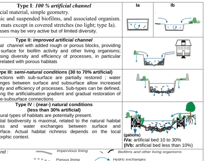
We use the concept of riverscape (see e.g. Malard et al. 2006), to define a typology of river stretches. It consists in a typical schematic cross-sections of each type, with a description of their characteristics, as well as expected biodiversity and diversity of processes. Table I sums up the typology proposed in the Polish catchment of the Bóbr river – a tributary of the Odra (Poulard et al., 2010). In this case, the percentage of artificial river-bed is a good indicator to rank the river stretches. The best adapted biotic indices for each type are also given in (Poulard et al., 2010) .
In turn, the people in charge of flood mitigation should explain their objectives and describe the structural measures they plan to build on the river catchment, insisting on the design features with an expected impact on the river and its ecosystems. The request of the biologists can therefore be expressed as: “achieve the best possible riverscape type” for each river reach.
Table 1. Proposed riverscape typology for Silesian mountain rivers (summary after Poulard et al., 2010)
Type I: 100 % artificial channel
Artificial material, simple geometry.
Benthic and suspended biofilms, and associated organism.
Moss mats except in covered stretches (no light; type Ia).
Processes may be very active but of limited diversity.Ia Ib
Type II: improved artificial channel
Artificial channel with added rough or porous blocks, providing more surface for biofilm activity and other living organisms; increasing diversity and efficiency of processes, in particular those related with porous habitats
Type III: semi-natural conditions (30 to 70% artificial) Connections with sub-surface are partially restored ; water exchanges between surface and subsurface allow increased diversity and efficiency of processes. Sub-types can be defined, following the artificialisation gradient and gradual restoration of surface-subsurface connections
Type IV : (near-) natural conditions (less than 30% artificial) All natural types of habitats are potentially present.
Potential biodiversity is maximal, related to the natural habitat richness and water exchanges between surface and subsurface. Actual habitat richness depends on the local geomorphic context.
IVa: artificial bed 10 to 30% (IVb: artificial bed less than 10%)
Legend : Biofilms and other living organisms
Hydric exchanges Impervious lining
Confronting riverscape types and civil engineering constraints
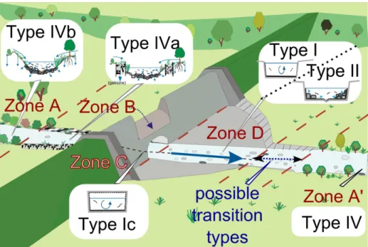
In parallel to the definition of relevant riverscapes, the main civil engineering requirements of a dry dam were defined (Poulard et al. 2010). The vicinity of a dam was divided into zones with respect to their function and for each of them the construction requirements were described ; the objective was to assign for each zone a riverscape corresponding to the best achievable status (Figure 2).
Zones A and A’ (downstream) have no particular requirement, so the river should be left alone or restored. Upstream the dam (zone B), some river training is useful to ensure the transition between the natural river and the bottom outlet. The bottom outlet (zone C) has a size directly derived from the mitigation requirements. Culverts are subject to underpressure flow during floods, so it can not be much better than type I ; open-trench slots (Figure 1d) are more open. The foot of the dam (zone D), where high-energy flows are expected during floods from the bottom outlet and from the overspill, also need a solid impervious lining. It could be improved to type II by adding big blocks, acting as energy-absorbers.
Figure 2. Schematic riverscape types assigned to river reaches in the vicinity of a dry dam. After all parties have agreed on best attainable types for each zone, it is possible to fine-tune the design by proposing adjustments to the cross-section or material. Improvements should be both useful and realistic. A discussion will often be needed because the answer is often case-dependent. For instance, it can be debated whether the foot of the dam can be improved to type II with a less simplistic cross section including a low-flow channel and added blocks. However, only very large blocks can withstand the high-energy flows, whereas smaller blocks are more efficient to increase the surface of substrate and offer shelter.
Similarly, the length of the trained reached and the choice of the bank protections type has to be discussed. Further questions were thus naturally raised about the relationship between river training, in particular bank protection material, and riverscape types.
Application of Riverscapes to River Training design
River training is a drastic solution regarding its environmental consequences, but in some places it remains necessary, especially where the river room is already channelized and room is now scarce. Suitability of riverscapes to describe trained reaches
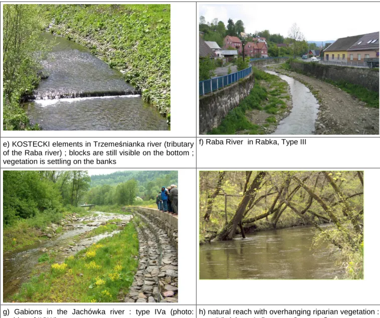
We thus followed a similar approach for river training in itself. Figure 3 illustrates the diversity of existing reaches in the same Polish mountainous area.
a) stonework : U-shaped early XXth century channel
(river Słonka in Rabka, PL) : type I
b) armoured strech of river downstream early XXth century dry dam (Norwegian Park, Jelenia Góra, PL) : type I
c) River Wątok in Tarnów, with low-flow channel and rough material on the bottom to increase the substratum surface : riverscape type II
d) improved artificial river cross-section, with low flows channel and bank armouring with Kostecki elements (built in 2003 ; river Wątok in Tarnów, Poland) : riverscape type II
e) KOSTECKI elements in Trzemeśnianka river (tributary of the Raba river) ; blocks are still visible on the bottom ; vegetation is settling on the banks
f) Raba River in Rabka, Type III
g) Gabions in the Jachówka river : type IVa (photo: archive of IIGW)
h) natural reach with overhanging riparian vegetation : type IVb (photo A. Dutartre, Cemagref)
Figure 3. examples of stretches of river and correspondence with riverscape
Water exchanges between riverbed and groundwater are decisive for biological functions, and indeed in our application the percentage of imperviousness was the key criteria for riverscape ranking. In this view, a trade-off must be found to ensure necessary solidity to withstand the expected current velocity, in particular during floods, with no excessive artificialness. Many possibilities exist to maintain vertical fluxes and allow vegetation to settle, and it appeared necessary to deepen this aspect.
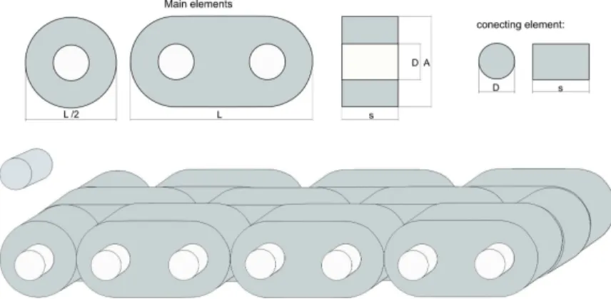
Our approach was applied in Lenar-Matyas and al. (2009), first to check if it was possible to assign a riverscape type to observed channels. Channels traditionally designed for flood evacuation had very artificial and homogenous shapes. Type I is not uncommon, even in recent realizations. All the other types were found in our sample of trained rivers, and our riverscapes typology allowed to describe all of them (Figure 3). However, the material used to line the banks can be partly porous, which makes the estimation of the percentage a bit tricky. Gabions (Figure 3f) are certainly more permeable than Kostecki blocks (Figure 3d,e), which are in turn more permeable than other rigid armouring. Kostecki elements, widely used in Poland, are modular concrete elements articulated with one another (Figure 4). Each block is impervious and very resistant, and yet the overall structure allows allows vertical water fluxes locally, and can follow irregular form of banks ; they will also adjust to soil movements. Vegetation can easily find roots in the interstices between the blocks, and can even completely hide the blocks (Figure 3d). We associate gabions with type IVa and Kostecki elements with type II, even if type II was defined with totally impervious lining. We could define an intermediate type here.
Moreover, permeability of the bank-protection materials is to a certain extent case-dependant, depending on age and clogging, specificities (size of the blocks for gabions, for instance) and spatial extension of the armouring.
Figure 4. Scheme of Kostecki elements and principle of assemblage
Riverscapes make it easy to classify these trained reaches and present the consequences of river-training on river ecosystems in a synthetic way, with relevant explanations for non-specialists about biodiversity and function potentials. The best situation, type IV in our riverscape typology, is not always attainable because of strong demand for flood protection and lack of space. The typology does not bring new solutions, but it provides a support for discussions during river training design. As for dams, trained channels should meet the hydraulic requirements (flood evacuation, resistance to erosion…) and yet let the river reach the best possible functional state.
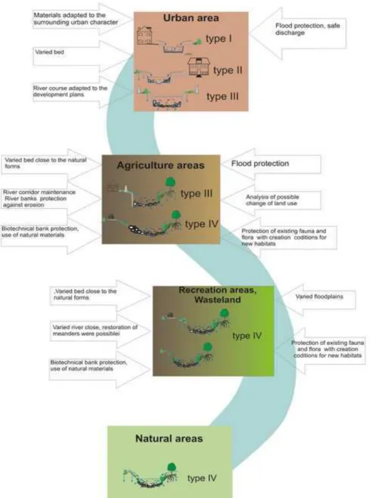
Lenar-Matyas and al. (2009) used the riverscapes typology as a support to present their suggestions to improve the trained reaches in urban and sub-urban areas. In urban areas, where flood-protection demand is often high, there are more constraints and the river has to remain locally embedded ; in contrast suburban areas allow more degrees of freedom for a better restoration plan, allowing a higher potential riverscape goal. They also propose a synthetic representation of the attainable riverscapes, completed by general recommendations, which we further develop and extend here (Figure 5).
Figure 5. Suggestions of attainable riverscapes with added recommendations (arrows) according to context (Augmented from Lenar-Matyas et al. 2009)
Applications in urban areas
(a) schematic U-shaped cross-section often found in Polish mountain streams (type I)
(b) schematic improved artificial cross-section (type II ; III with a more porous bank lining)
Figure 6. detailed possible improvements in river training after (Ratomski 2004) from type I to type II or III (with Q1% and Q100% respectively centennial and low-flow levels)
Figure 3c and d present an example of recent trained channel in a urban area, with restricted space and limited possibilities to change the cross-section. Figure 6 sums up the improvements made compared to the previous state: the cross-section includes a low-flow channel with sufficient depth ; bank protection allow vertical fluxes and have a gentle slopes, they can retain a soil for vegetation (Ratomski, 2004; Lenar-Matyas et al. 2009). Assigning a riverscape type to initial (Figure 6a) and objective situation (Figure 6b) helps to highlight and quantify the effect of the changes.
Some improvements are not yet satisfactorily taken into account in the present form or riverscapes typology. Bed slope and stream sinuosity were kept or, up to the local possibilities, restored with a bank line rather irregular. In the channel riffles, pools and big stones were preserved, or created, in order to facilitate the development of epilithal fauna and flora. Riparian vegetation is an interesting habitat in itself, and furthermore supplies shade and nutrients to the river. Beside, roughness of vegetated banks will slow the water velocity.
Applications in sub-urban areas
In rural or suburban areas, where there is more room, further adjustments towards a natural functioning can be proposed, allowing a higher potential riverscape goal. It is possible to enlarge the channel and to favour natural vegetation. The cross-section shape should be irregular, but there is no need to restore the channel pattern in details. In natural channels, the shape results from long –term hydromorphological processes depending on stream alignment, sediment grading and transport, hydrological regime. Thus, movable alluvial channels with varied slope and certain degree of freedom will develop natural heterogeneous patterns.
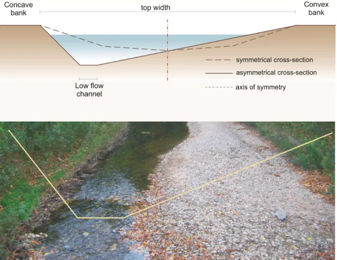
Lenar-Matyas et al. (2009) point other recommendations : in bends, the design must be carefully adapted to suit the natural pattern, with different slopes in convex and concave banks, (Figure 7). The channel depth should be compatible with the erosion processes in the river bed. Since the authors encountered many examples of faulty protections, we shall remind here that armouring thickness must be carefully calculated, in particular in the concave part of bends.
Figure 7. top : Recommended asymmetrical cross-section in bends and practical example (photo: archive of IIGW)
Discussion : extension of the concept of Riverscapes
Our first scheme appears suitable for local projects, such as dry dam designs, but it has some limitations when used in a broader project. Applying it to river training helped us identify the following limits :
• the representation we chose (Figure 1) seems to concentrate on the cross section ; longitudinal parameters such as slope and cross-section heterogeneity do not appear visually.
• Since heterogeneity is important, and river training has to be limited to what is necessary, we might encounter patchy reaches such as illustrated by Figure 8, for which assigning one pre-defined riverscape type is not straightforward .
• for our purposes, the percentage of artificialness was a good scale. The typology is case-dependent, in other, broader schemes, the typology has probably to be richer and to include other variables (for instance, riparian vegetation, floodplain land-use, river bed material…). In a less- linear, branched typology, it is not so clear whether one type is intrinsically better than the other. A solution is to define two-digits riverscape types, where the first digit is a score or a rank, like in our present typology for the Polish mountain streams, and the second digit (or letter) a sub-type which corresponds to a variant, to be considered at the same level as those of the same rank.
Figure 8 : sketch of a heterogeneous reach of river
Conclusions
An approach based on riverscapes allows to share information, but it needs a preparation phase to define the riverscapes, and much concertation.
The riverscape typology is site-dependant, and a field campaign is necessary, but also case-dependant. We insist that we do not envisage any “universal catalogue of riverscapes” containing all the requested experts’ knowledge ; it is exactly the contrary. We could say that “there is in riverscapes what you bring in it ”; the cross-sections are the most visual output, but they are insufficient without the added comments : description of the type, expected river processes and biodiversity, and any other relevant comment or indicators.
It is possible that after a typology has been defined, the first discussions where the flood project manager expresses his constraints and needs will lead to a complete re-formulation of the riverscapes. They can also be revised and enriched by other specialists, such as terrestrial biologists, when relevant. The issue is that the riverscape typology should contain all the relevant information for the discussions of a given project, in order to lead to fruitful discussions about the effect of the technical choices on the river status, and to encourage co-conception and suggestions of relevant modifications whenever possible.
Acknowledgements
The present was partly supported by ECONET funds, which made French-Polish collaboration possible. We are also indebted to EPAMA (F, in charge of the flood management in the French Meuse Basin, www.epama.fr), M. Sadowski of the RZGW Inspectorate of Jelenia Gora (PL), Grand Roanne local authority (F), and all the people who shared with us information and comments about dry dams and river training.
References
Breil, P., M. Lafont, T. D. Fletcher, and A. Roy, 2008: Aquatic ecosystems. In: Data Requirements
for Integrated Urban Water Management (ed. by Fletcher T. D & Deletić A.), Taylor and Francis group, London, 262-274.
E.U., 2000: Water Framework Directive, Directive 2000/60/CE of the European Parliament and of the
Council of 23 October 2000, establishing a framework for community action in the field of Water Policy.
E.U., 2007: Water Framework Directive, Directive 2007/60/CE of the European Parliament and of the
Council of 23 October 2007, on the assessment and management of flood risks.
E.U. Commission, 2004 : Best practices on flood prevention, protection and mitigation, 29 p. (http://ec.europa.eu/environment/water/flood_risk/com.htm)
Geilen, N., H. Jochems, L. Krebs, S. Muller, B. Pedroll, T. Van der Sluis, K. Van Looy, S. Van Rooij, 2004: Integration of ecological aspects in flood protection strategies: defining an ecological
Ghavasieh, A.R., C. Poulard, A. Paquier, 2006: Effect of roughened strips on flood propagation:
assessment on representative virtual cases and validation. J. Hydrol. 318(1-4), 121-137.
Lafont, M., J. Marsalek, P. Breil 2008: Urban Aquatic Habitat characteristics and functioning. In:
Aquatic Habitats in Integrated Urban Water Management (ed by. Wagner, I., Marsalek, J. and Breil, P.), Taylor & Francis group, London, 9-24.
Lenar-Matyas, A., M. Lafont, M. Lapuszek, C. Poulard, 2009 : Alleviating effects of technical
training of mountainous rivers and streams in urban areas, Infrastruktura i Ekologia Terenów Wiejskich, 9, 241-251 (in Polish).
Loucks, D. P., 2006: Modeling and managing the interactions between hydrology, ecology and
economics. Journal of Hydrology, 328: 408-416.
Poff, N. L., J. D, Allan, M. B. Bain, J. R Karr., K. L. Prestegaard, B. D Richter., R. E. Sparks and J. C. Stromberg, 1997: A paradigm for river conservation and restoration. BioScience, 47, 769-784. Poulard, C., J. Szczesny, H. Witkowska, K. Radzicki, 2005: Dynamic Slowdown: A flood mitigation
strategy complying with the Integrated Management concept - Implementation in a small mountainous catchment. Journal of River Basin Management, 3(2), 75 – 85.
Poulard C., B. Chastan, P. Royet, G. Degoutte, F. Grelot, K. Erdlenbruch, Y. Nédélec, 2009:
Dynamic Flood Retention: principle and guidelines, Ingénieries EAT, Special Issue on Flood Prevention, June 2009, 5-24 (in French).
Poulard C., M. Lafont, A. Lenar-Matyas, M. Łapuszek, 2010: Flood mitigation designs with respect
to river ecosystem functions - a problem oriented conceptual approach, Ecological Engineering, 36(1), 69-77
WMO, 2004 : Integrated Flood Management Concept Paper, Associated Programme on Flood