HAL Id: halshs-01933726
https://halshs.archives-ouvertes.fr/halshs-01933726
Submitted on 24 Nov 2018
HAL is a multi-disciplinary open access
archive for the deposit and dissemination of
sci-entific research documents, whether they are
pub-lished or not. The documents may come from
teaching and research institutions in France or
abroad, or from public or private research centers.
L’archive ouverte pluridisciplinaire HAL, est
destinée au dépôt et à la diffusion de documents
scientifiques de niveau recherche, publiés ou non,
émanant des établissements d’enseignement et de
recherche français ou étrangers, des laboratoires
publics ou privés.
Connectivity in the Mediterranean
Jean-François Arvis, Vincent Vesin, Robin Carruthers, César Ducruet, Peter
de Langen
To cite this version:
Jean-François Arvis, Vincent Vesin, Robin Carruthers, César Ducruet, Peter de Langen. Maritime
Networks, Port Efficiency, and Hinterland Connectivity in the Mediterranean. World Bank Group,
http://hdl.handle.net/10986/30585, 2018, International Development in Focus, 978-1-4648-1274-3.
�halshs-01933726�
w orks, P or t Efficienc y, and Hint erland Connec tivit y in the Medit erranean Ar vis, V
esin, Carruthers, Ducruet, and de Langen
INTERNA
TIONAL DE
VEL
OPMENT IN FOCUS
Maritime Networks,
Port Efficiency, and
Hinterland Connectivity
in the Mediterranean
Jean-François Arvis, Vincent Vesin, Robin Carruthers,
César Ducruet, and Peter de Langen
Public Disclosure Authorized
Public Disclosure Authorized
Public Disclosure Authorized
Maritime Networks,
Port Efficiency, and
Hinterland Connectivity
in the Mediterranean
Jean-François Arvis, Vincent Vesin,
Robin Carruthers, César Ducruet, and
Peter de Langen
Telephone: 202-473-1000; Internet: www.worldbank.org Some rights reserved
1 2 3 4 22 21 20 19
Books in this series are published to communicate the results of Bank research, analysis, and operational experience with the least possible delay. The extent of language editing varies from book to book.
This work is a product of the staff of The World Bank with external contributions. The findings, inter-pretations, and conclusions expressed in this work do not necessarily reflect the views of The World Bank, its Board of Executive Directors, or the governments they represent. The World Bank does not guarantee the accuracy of the data included in this work. The boundaries, colors, denominations, and other informa-tion shown on any map in this work do not imply any judgment on the part of The World Bank concerning the legal status of any territory or the endorsement or acceptance of such boundaries.
Nothing herein shall constitute or be considered to be a limitation upon or waiver of the privileges and immunities of The World Bank, all of which are specifically reserved.
Rights and Permissions
This work is available under the Creative Commons Attribution 3.0 IGO license (CC BY 3.0 IGO) http:// creativecommons.org/licenses/by/3.0/igo. Under the Creative Commons Attribution license, you are free to copy, distribute, transmit, and adapt this work, including for commercial purposes, under the following conditions:
Attribution—Please cite the work as follows: Arvis, Jean-François, Vincent Vesin, Robin Carruthers,
César Ducruet, and Peter de Langen. 2019. Maritime Networks, Port Efficiency, and Hinterland
Connectivity in the Mediterranean. International Development in Focus. Washington, DC: World Bank. doi:10.1596/978-1-4648-1274-3 License: Creative Commons Attribution CC BY 3.0 IGO
Translations—If you create a translation of this work, please add the following disclaimer along with the
attribution: This translation was not created by The World Bank and should not be considered an official
World Bank translation. The World Bank shall not be liable for any content or error in this translation.
Adaptations—If you create an adaptation of this work, please add the following disclaimer along with the
attribution: This is an adaptation of an original work by The World Bank. Views and opinions expressed in
the adaptation are the sole responsibility of the author or authors of the adaptation and are not endorsed by The World Bank.
Third-party content—The World Bank does not necessarily own each component of the content
con-tained within the work. The World Bank therefore does not warrant that the use of any third-party-owned individual component or part contained in the work will not infringe on the rights of those third parties. The risk of claims resulting from such infringement rests solely with you. If you wish to re-use a component of the work, it is your responsibility to determine whether permission is needed for that re-use and to obtain permission from the copyright owner. Examples of components can include, but are not limited to, tables, figures, or images.
All queries on rights and licenses should be addressed to World Bank Publications, The World Bank Group, 1818 H Street NW, Washington, DC 20433, USA; e-mail: [email protected].
ISBN: 978-1-4648-1274-3 DOI: 10.1596/978-1-4648-1274-3
Cover photo: © Tanger Med. Used with the permission of Tanger Med. Permission required for reuse. Cover design: Debra Naylor / Naylor Design Inc.
iii
Foreword vii Preface ix
Acknowledgments xiii About the Authors/Editors xv Executive Summary xvii Abbreviations xxvii
CHAPTER 1: Dimensions, Indicators, and Drivers of Trade Connectivity in the Mediterranean 1
The Mediterranean: The nexus of world trade or its own small world? 1
Trade connectivity and economic development 4 Measuring trade connectivity: Indicators 7 Using indicators to measure performance of
the main Mediterranean ports 10 Drivers of trade connectivity 12 Connectivity patterns 13
Annex 1A: Potential indicators at the country and port levels 14 Notes 16
References 17
CHAPTER 2: Maritime Networks and Port Efficiency 19 The global connectivity of Mediterranean ports 19 Local connectivity of Mediterranean ports 25 A typology of Mediterranean ports by maritime networks
and port efficiency 36
Annex 2A: Data and methodology 38
Annex 2B: Explanation of network measures 40
Annex 2C: Top 20 Mediterranean ports by traffic performance and network centrality scores 40
Notes 45 References 45
CHAPTER 3: Hinterland Connectivity 47 Indicators of hinterland connectivity 47 Annex 3A: Identifying a port’s hinterland 60 Characteristics of port hinterlands 60 Notes 66
CHAPTER 4: Three Case Studies on the Connectivity of Ports 69 Port market shares in Spain 69
Port Said East (Egypt) 72 Tanger Med (Morocco) 75
Annex 4A: Port choice: Statistical analysis of Spain 78 Data 78
Notes 83 References 84
CHAPTER 5: Enhancing Connectivity and Port Development Strategies 85
Port development strategy and hinterland dynamic 85 A typology of ports by connectivity and development
strategy 87
Patterns of port development and evolutionary strategies in the Mediterranean 88
Notes 91 References 92
Appendix A: Guide to Port Locations 93
Appendix B: Descriptions of 17 Major Mediterranean Ports 95 Glossary 105
Boxes
1.1 The liner shipping connectivity index 7 1.2 The logistics performance index 8 3.1 The size of a port’s hinterland 48
3A.1 Identifying port hinterlands in Morocco 64 Figures
ES.1 Three dimensions of trade connectivity xviii ES.2 Three port development paths and strategies xxii ES.3 Typology of port connectivity xxiii
1.1 Three dimensions of trade connectivity 6
B1.1.1 Liner shipping connectivity index values for major hubs and gateways, 2004–16 8
B1.2.1 Logistics performance index values for selected countries, 2007–16 9 1.2 Breakdown of modes in total short-sea shipping traffic in European
regions, 2015 11
2.1 Extra-Mediterranean traffic of Mediterranean ports, by region, 2009–16 20
2.2 Foreland specialization of top 10 Mediterranean ports, 2015 24 2.3 Traffic concentration among Mediterranean nodes and links,
2009–15 26
2.4 Share of intra-Mediterranean traffic, direct/adjacent and all calls, 2009–16 26
2.5 Intra-Mediterranean traffic distribution by subregional maritime range, all calls, 2009–16 27
2.6 Average traffic size and standard deviation of traffic growth rates in the Mediterranean, 2009–15 29
2.7 Vulnerability and traffic volume of Mediterranean ports, 2015 32 2.8 Subnetworks in the Mediterranean, 2015 33
2.9 Vessel turnaround times in the Mediterranean for all vessels and post-Panamax-plus vessels, 2009–16 (number of days) 35 2.10 Average vessel turnaround time versus number of vessel calls in the
Mediterranean, 2009–16 35
2.11 Principal components analysis of Mediterranean ports, 2015 37 2.12 Global versus local connectivity of Mediterranean ports, 2015 38
2A.1 Methodology of network construction from Lloyd’s List Intelligence data 39
3.1 Travel time on the main port access road, Algeciras (Spain) and Piraeus, 2016 52
3A.1 The all–road versus feedering costs of a region 63 4.1 Likelihood of choosing a port and port throughput 72 5.1 Three port development paths and strategies 86 5.2 Typology of port connectivity 88
Maps
1.1 Trade routes in the Roman Empire 2 1.2 Global trade flows, 2009–16 2
1.3 Shipping patterns in the Mediterranean, 2009–16 3
1.4 Shipping routes and diversion distances in the Mediterranean, 2015 3 2.1 Share of extra-Mediterranean traffic in total traffic at Mediterranean ports,
2015 21
2.2 Share of Mediterranean traffic at non-Mediterranean ports, 2009–15 22 2.3 Mediterranean and other transshipment regions 23
2.4 Optimal trajectory (trunk line) with the least diversion distance 25 2.5 Traffic volume and share of alliance-related traffic, 2015 25 2.6 Six port clusters grouped according to traffic trajectory 30 3.1 Barcelona’s hinterland network, 2010 53
3.2 Inland nodes served by Marseilles port, 2016 56
3.3 Proposed new facilities to expand the hinterland of East Port Said 58 3.4 Tanger Med is two ports in one 59
B3A.1.1 Two hinterlands for Tanger Med, model result, based on 2016 data 65 4.1 Regions of Spain 70
Tables
1.1 Examples of trade connectivity models 9
1.2 Container and roll-on, roll-off volume for short-sea, selected European countries, 2015 11
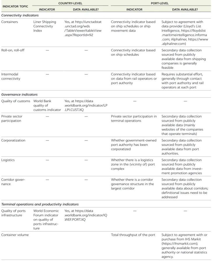
1.3 Liner shipping connectivity index values in the Mediterranean 14 1A.1 Full menu of port performance indicators, with country- and
port-level indicators 15
2.1 Mediterranean network patterns, 2009–16 28 2C.1 Total vessel traffic, 2009–16 41
2C.2 Betweenness centrality, 2009–16 42 2C.3 Degree centrality, 2009–16 43 2C.4 Clustering coefficient, 2009–16 44 3.1 Indicators of hinterland connectivity 48
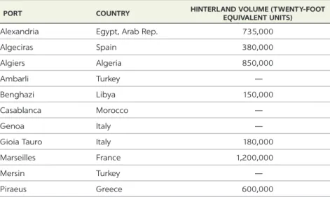
3.2 Hinterland volume of selected Mediterranean ports, 2015 48 3.3 Modal split of selected Mediterranean ports, 2015 49
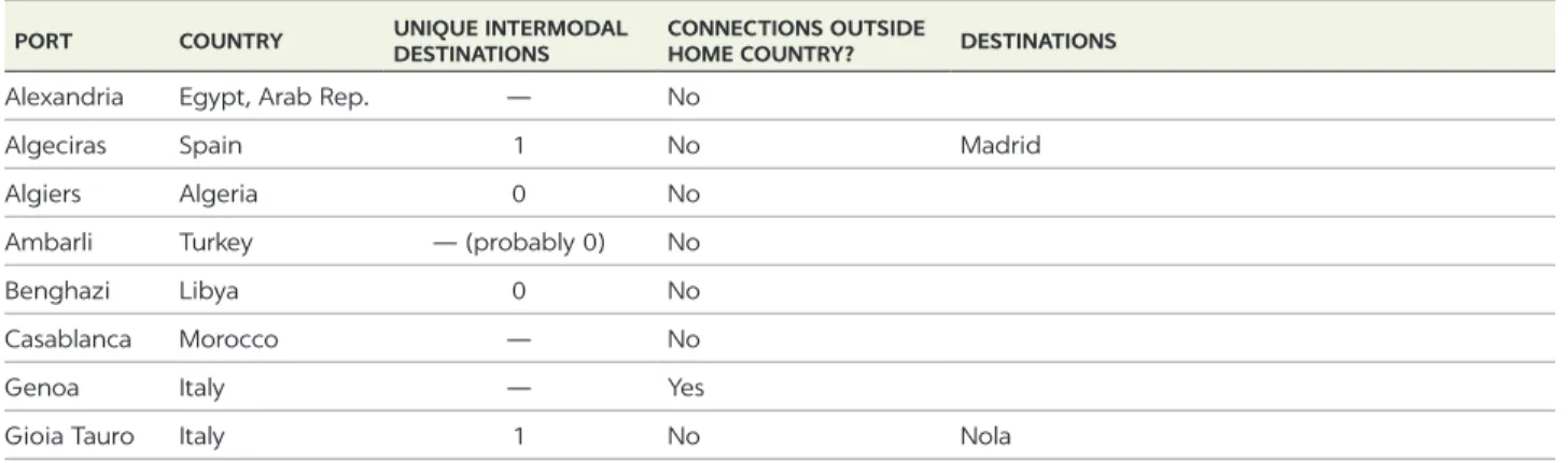
3.4 Intermodal connectivity of selected Mediterranean ports, 2016 50 3.5 Container traffic statistics for Barcelona 54
3.6 Inland volume and modal split of Marseilles 55
B3A.1.1 Road distance matrix between all regions and the main ports of Morocco 64
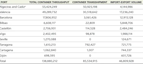
B3A.1.2 Maritime distance and maritime connectivity with four world regions 65 4.1 Traffic of main container ports in Spain, 2016 70
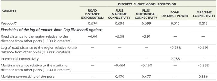
4.2 Subset of coefficients that influence the likelihood of choosing a port 71 4.3 Traffic of Egyptian ports, 2015 73
4.4 Container truck tariffs from ports to the Cairo metropolitan area, 2013 74 4.5 Industrial zones in Tanger Med 77
4A.1 Intermodal connectivity of the port of Algeciras (Spain), 2016 81 4A.2 Distances in nautical miles from Spanish ports to four main
world regions 81
4A.3 Estimation of the port choice model for Spain 82 B.1 Performance indicators, Alexandria, 2016 96 B.2 Performance indicators, Algeciras, 2016 96
B.3 Performance indicators, Algiers, 2016 97 B.4 Performance indicators, Ambarli, 2016 97 B.5 Performance indicators, Benghazi, 2016 98 B.6 Performance indicators, Casablanca, 2016 98 B.7 Performance indicators, Genoa, 2016 99 B.8 Performance indicators, Gioia Tauro, 2016 99 B.9 Performance indicators, Marsaxlokk, 2016 100 B.10 Performance indicators, Marseilles, 2016 100 B.11 Performance indicators, Mersin, 2016 101 B.12 Performance indicators, Piraeus, 2016 101 B.13 Performance indicators, Port Said, 2016 102 B.14 Performance indicators, Radès, 2016 102 B.15 Performance indicators, Sines, 2016 103 B.16 Performance indicators, Tanger Med, 2016 103 B.17 Performance indicators, Valencia, 2016 104
vii
Maritime Networks, Port Efficiency, and Hinterland Connectivity in the
Mediterranean is an opportunity for me to reaffirm how greater regional
integra-tion is essential to achieving peace and stability in the Middle East and North Africa Region (MENA). I recognize that this is easier said than done in such a challenging regional and global environment, but make no mistake: it is now that cooperation in the Mediterranean is needed the most. Greater cooperation can help address the roots of instability in the region, as well as deal with the imme-diate consequences of migration and refugees, and provide knowledge and access to global markets in the long-term. More integration will promote trade and new economic and social policies that will create jobs and foster sustainable growth.
This book provides a rigorous assessment of one of the complex pieces of this urgent agenda. It studies the network of maritime transport across the Mediterranean, a subject of economic and social interests dating back centuries.
Due to its position in global trade, the Mediterranean indeed remains a labo-ratory of the global hub-and-spoke network pattern. It hosts the port of Tanger Med and the now expanded Suez Canal on the southern rim, two examples of the massive investments in transport and logistics infrastructure that we have seen in the 21st century. Yet fundamental questions still remain to be answered: What are the values and the benefits of global connectivity? What are the economic benefits of massive investments in infrastructure often financed by taxpayers? I often hear these two questions when I meet with government officials across the region. Hubs are critical for transshipment, but risk becoming an economic enclave. What do we need to do to make sure excellent global connectivity trans-lates into economic opportunities for people and firms in the natural hinterland?
This book is the first to tackle these obvious but essential questions. It is valu-able to policy makers and private partners who look for solutions to unleash hin-terland development. It provides cross-cutting knowledge in transportation and trade. It combines empirical work and experience with a series of case studies, addressing the complex relationship between maritime networks, port effi-ciency, and hinterland connectivity.
Because of the urgency of what is at stake for the Mediterranean and global communities, Maritime Networks, Port Efficiency, and Hinterland Connectivity in
the Mediterranean provides a timely piece of rigorous analytical work. I look
for-ward to witnessing its ripple effects across the Mediterranean in the policy discussions that we must have.
Hafez Ghanem
Vice President
Middle East and North Africa The World Bank
ix Carved out millions of years before mankind reached its coasts, the
Mediterranean Sea became a “sea between the lands” linking opposite shores once human beings traversed its surface in search of habitation, food or other vital resources.
—David Abulafia For millennia the Mediterranean1 has been a place of trade, where ports and sea
routes sustain the prosperity of city-states and their economic hinterlands. Politics, shifts in trade routes, and competition for influence by cities, states, and empires at the rim have influenced the growth and decline of the economies around the sea.
Several of the greatest students of history, following Fernand Braudel,2 have
produced keen insights on growth patterns at the nexus between history and eco-nomics. The extraordinarily rich example of the Mediterranean guided and inspired this endeavor in the last century. Braudel and his followers observed that the Mediterranean is the cradle of modern trade and the first example of globalization within its area of influence, even before the industrial revolution. The Mediterranean was the foremost example of an earlier world economy. It is more than its sea routes: it is an extended network of maritime and hinterland routes and trading centers.
Many of today’s ports are in the same spots as—or very close to—the trade hubs of antiquity or the Middle Ages. Take Tunisia: the country’s main port, Radès, is close to the current capital, Tunis, and even closer to Carthage, the formidable trading and military city-state of the mid-first millennium B.C.E. Carthage was linked to the rest of Mediterranean and outposts in Western Europe and West Africa. Although the Romans destroyed the city at the end of the Third Punic War, the old port that was the hub of Mediterranean (and wider) trade some 25 centuries ago is still visible. Where the quiet public park there now sits may have been the closest thing at the time to today’s trade powerhouses of Long Beach, Rotterdam, or Shanghai. The port was the hub of a huge wheel that hosted and served merchant and fighting ships.
How times change. Radès may now have even fewer connections than Carthage used to have. Instead of being the trade center of one of the world’s leading economies, it is a port served mainly by the larger ports or shipping hubs
in Italy, Spain, and the Eastern Mediterranean and is connected by ferries with a few destinations in France and Italy. Thus Tunisia has direct links only to its closest European trade partners. How to improve the performance of this system and catalyze the international integration of local firms is a central concern of Tunisian policy makers, who have been considering building a deep-sea port to attract large ships operating over long distances.
Further west, Morocco has invested heavily in a major container transship-ment hub at Tanger Med on the Strait of Gibraltar. It is extending the hub and building a similar hub on the Nador Peninsula, across the strait from Almeria in Spain. These investments connect Morocco globally, but do they create opportu-nities in the Moroccan economy beyond direct jobs in the port community? Policy makers in Morocco and in virtually every other country investing in maritime capacities expect the hinterland to enjoy the benefits of connectivity improvements, which go far beyond port investment to include a range of inter-ventions and policy options such as local investment, spatial policies, and indus-trial policies. Tanger Med is generally viewed as a success: it helped attract foreign investment and generate new manufacturing activities, including the first export-oriented automotive cluster in Africa.
Today trade connectivity in the Mediterranean combines lessons from the past identified by economic historians with 21st century approaches. The Mediterranean is no longer a world economy in itself but a link in the global chain of trade, a place of transit for global container shipping organized around China, Singapore, the Panama Canal, the Strait of Gibraltar, and the Suez Canal. Its sea routes no longer operate on a point-to-point system within the rim but as a hub-and-spoke system where local shipping links transshipment hubs to regional ports. Such hubs are at the eastern and western ends of the Mediterranean (the Arab Republic of Egypt, Morocco, and Spain), and at the pivot between the east and west (around Sicily). Maritime capacity is being built in Southern Mediterranean countries, massively so in Morocco and Egypt, but because of limited financial resources, these countries are highly concerned with their investment returns and the resulting benefits. Major initiatives from farther afield are re-enforcing the need to get these policy options right, such as China’s One Belt, One Road, whose investments in main trade routes include the Mediterranean.
These policy considerations inspired this report. It does not aim to be an ency-clopedia of maritime patterns or of economic development in Mediterranean countries but a practical exploration of the links among maritime networks and trade, ports, and hinterland development. It defines trade connectivity and its com-ponents at different levels: global, port, and hinterland. It explores the policy dimensions of trade connectivity with a focus on maximizing impact. The Mediterranean is a useful laboratory to understand patterns and policies—an understanding that can be profitably used elsewhere—as it combines rich maritime and trade patterns, has economies that differ in development and connectivity, and displays varying policies and outcomes for hinterland development.
The report is intended for a wide readership of policy makers in maritime affairs, trade, or industry; professionals from the world of finance or develop-ment institutions; and academics. It combines empirical analysis of microeco-nomic shipping and port data with three case studies of choice of port (focusing on Spain, Egypt, and Morocco) and five case studies on hinterland develop-ment (Barcelona; Malta; Marseilles; Port Said East, Egypt; and Tanger Med, Morocco).
NOTES
1. From the Latin words medius (middle) and terra (earth or land). In this report, the Medi-terranean goes beyond all coastal countries bordering the MediMedi-terranean Sea to include parts of the Atlantic Iberian Peninsula from southwestern Spain up to north Portugal and Atlantic Morocco down to the Casablanca port cluster. It also includes western Black Sea ports in Bulgaria, Romania, Turkey, and Ukraine (to the port of Yuzhny). This extended definition is useful to grasp essential features of recent port dynamics, such as the develop-ment of a new container port at Sines (Portugal) in the mid-2000s, the rivalry between Casablanca and Tangier, and the growth of transshipment activities at eastern Mediterra-nean ports tied to the expansion of Black Sea ports.
2. Fernand Braudel (1902–85) was a French historian who deeply influenced historical sciences in the second half of the 20th century. His landmark books Mediterranean and
Civilization and Capitalism pioneered the study of socioeconomic factors as history drivers.
REFERENCES
Abulafia, D. 2013. The Great Sea. Oxford, Uk: Oxford University Press. Braudel, F. 2009. La Méditerranée : l’espace et l’histoire. Paris: Flammarion.
xiii This publication was led by Jean-François Arvis and Vincent Vesin. The other
authors include Robin Carruthers, César Ducruet, and Peter de Langen. This work was a collaboration between the Macroeconomics, Trade and Investment Global Practice, and the Transport and Digital Development Global Practices at the World Bank. The authors would like to thank the following Practice Managers for their guidance: Olivier Le Ber, José-Guillerme Reis, and Nicolas Peltier. The authors would also like to thank for their support the management of the Middle East and North Africa Region at the World Bank led by Vice President Hafez Ghanem.
This book would not be possible without the guidance and input of many colleagues at the World Bank, in the maritime professions, or in academia. They include Cordula Rastogi, Christina Wiederer, Vickram Cuttaree, Chaymae Belaoui, Olivier Hartmann, Matias Herrera, Gerald Ollivier, Jean-Paul Rodrigue, Jamal Benjelloun, Mehdi Tazi, Said Elhadi, Antoine Fremont, Lori Tavasszy, Jan Hofmann, Marie Metge, Zineb Benkirane, Justin Berli and Mattia Bunel.
xv
Jean-François Arvis, a Senior Economist with the International Trade Department at the World Bank, has been leading the development of advisory work, indicators, and knowledge products in the area of logistics, connectivity, and networks. Prior to joining the Bank, he worked in senior positions with the French Ministry of Economy and Industry (regulation, trade, finance, and development aid). He is a graduate of the École Normale Supérieure in Paris and École Nationale Supérieure des Mines, and holds a doctorate degree in physics.
Robin Carruthers has a first degree in economics and political institutions, a master’s degree in statistics, and is a member of the Chartered Institute of Transport and Logistics. Following two decades as Transport Consultant in Australia, Europe, and South America, he joined the World Bank as a Transport Economist. At the Bank, he managed transport and logistics-related projects and studies in each of its six regions, and he supervised its worldwide transport eco-nomics activities. He retired from the Bank in 2003. Since then he has been an independent consultant to the United Nations, the World Bank, all the regional development banks, other development agencies, and private companies active in developing countries. He is currently supporting the World Bank in its advice on transport and logistics strategies for Saudi Arabia and Jordan and on road pricing in the United Arab Emirates.
César Ducruet, geographer, is Research Director at the French National Centre for Scientific Research, Paris. His work focuses on transport geography and network science with applications to Europe and Asia. Working as an expert for various organizations—the Organisation for Economic Co-operation and Development, World Bank, korea Maritime Institute, and Japan External Trade Organization (JETRO)—he is currently the Principal Investigator of the World Seastems research project funded by the European Research Council (2013–19). He recently edited two books, Maritime Networks (2015) and Advances in Shipping Data Analysis and Modeling (2017) in the Routledge
Studies in Transport Analysis series, in addition to authoring many articles
Peter de Langen is the owner and principal consultant of Ports & Logistics Advisory, and he is Visiting Professor at Copenhagen Business School. de Langen held a part-time position as Professor, Cargo Transport & Logistics, at Eindhoven University of Technology (2009-16), and worked at Port of Rotterdam Authority (2007-13). de Langen is Co-Director of the knowledge dissemination platform, “http://www.porteconomics.eu” www.porteconomics.eu. Since 2016, de Langen has worked in various projects as consultant for the World Bank.
Vincent Vesin is a Senior Transport Specialist at the World Bank in Washington, DC. He joined the World Bank in 2008 and has been leading projects and studies in North Africa, West Africa, and the Middle East in the road, airport, and port sectors. Vesin’s current primary interests center around regional integration, rural mobility, and climate resilience. He is a graduate of École Polytechnique in Paris and holds master’s degrees in engineering from École Nationale des Ponts et Chaussées (now called École des Ponts ParisTech) in Paris, and the University of Michigan. Prior to joining the World Bank, he worked in aviation in the pri-vate sector.
xvii The Mediterranean has been one of the most active trading areas for millennia.
Trade—and by extension connectivity—between Mediterranean riparian coun-tries is one of the oldest and most studied topics in economic history. The Mediterranean has complex trade patterns and routes—but with key differences from the past. It is no longer an isolated world economy: it is both a trading area and a transit area linking Europe and North Africa with the rest of the world through the hub-and-spoke structure of maritime networks (see chapter 1).
Understanding how trade connectivity works in the Mediterranean, and else-where, is important to policy makers, especially those in developing countries in the Mediterranean, concerned with the economic benefits of large investment in infrastructure. Better connectivity is expected to increase trade with distant markets and stimulate activities in the hinterland. The interconnectedness of shipping and trade networks means that benefits in one place depend on global and regional patterns. However, local intervention can enhance those benefits. Lessons from the Mediterranean may prove relevant to other regions, so this report was undertaken with both a regional focus and globally scalable lessons in mind.
DIMENSIONS, DRIVERS, AND INDICATORS OF
TRADE CONNECTIVITY
Trade connectivity has three interdependent dimensions—maritime networks (also referred to as shipping networks), which refer to the structure and mance of shipping before the port; port efficiency, which refers to the perfor-mance of the port (or group of ports sharing the same hinterland); and hinterland connectivity, which involves multiple players and institutions contributing to economic development and exploiting maritime supply chains (figure ES.1). Policies that work well for one dimension can have a positive impact on the oth-ers; policies that take all three dimensions into account have greater impact than policies that focus on a single dimension.
Maritime networks in the Mediterranean have their own hierarchy, with a pronounced distinction between hub and gateway ports (see chapter 2). Hub ports all have a low diversion distance from the Mediterranean’s maritime trunk line, the optimal shipping route between the Strait of Gibraltar and the Suez Canal. The number of transshipment hubs suggests intense competition for transshipment cargo: while ports in Africa are closest to the main shipping routes, most transshipment ports are in Europe—with the notable exception of Tanger Med (Morocco) and Port Said East (the Arab Republic of Egypt)— pointing to major transshipment opportunities along the North Africa shore. Gateway ports in the Mediterranean serve the same role as they do elsewhere: they are the maritime trade gateways to their hinterlands, accounting for most of their hinterland’s containerized trade.
Maritime networks in the Mediterranean, particularly those in the Western Mediterranean, also use networks of roll-on, roll-off vessels to transport much the same mix of products that is moved in containers. Roll-on, roll-off is espe-cially important for trade between Africa and Europe. Intermodal connectiv-ity should be important for gateway ports but is very limited, except for Marseilles.
Container-terminal productivity differs widely across ports. It improves with throughput volume because it rises with ship size (more cranes can be used at the same time on larger ships) and with call size (the number of containers han-dled per vessel), enabling more-efficient operations. The productivity of the landlord port model (where container terminals are leased or concessioned to private operators) is higher than that of the public sector port model (where terminals are operated directly by the port authority).
The three dimensions of trade connectivity have complementary drivers of growth and efficiency. The main drivers for each dimension tend to differ, but some address more than one dimension.
The main drivers of maritime networks are industry strategies by shipping lines. Major players such as CMA CGM, Maersk, and Mediterranean Shipping Company (along with Asian, especially Chinese, companies), have been FIGURE ES.1
Three dimensions of trade connectivity
Physical networks
Soft and hard infrastructure Indicators Supply chain, logistics performance indicators Port performance and port logistics indicator Network metrics Hubs and spokes Maritime
connectivity efficiencyPort
Port(s) system Hinterland connectivity Logistics facilities Economic zones Services Institutions
consolidating their operations and are pushing for a hub-and-spoke port system. Such a system also involves regionally focused shipping lines that feed secondary ports in the Mediterranean.
The main drivers of policy interventions for port efficiency have been port and terminal operators implementing new port management methods, develop-ing public–private partnerships, and improvdevelop-ing port logistics and trade facilitation.
The main drivers of hinterland connectivity are national and regional govern-ments, through their regional and economic strategies. Government actions include implementation of hard and soft infrastructure interventions, such as connecting infrastructure to existing economic growth poles and setting up industrial and logistics export-oriented facilities (for example, special economic zones). Port authorities are also drivers: they look to extend their port’s outreach by making arrangements with and investing in the facilities of operators of inland terminals, logistics zones, and rail networks and by actively promoting their ser-vices in areas beyond their traditional hinterland (see chapter 3).
THE MEDITERRANEAN’S MARITIME NETWORKS
The Mediterranean has polycentric but increasingly centralized maritime net-works. This centralization reflects a strong east–west divide, with port connec-tivity differing greatly in scale and scope across the largest ports. Traffic from major shipping alliances appears to be an important driver of maritime connec-tivity and port efficiency. Maritime networks have a global and local scale (see chapter 2).
Global networks
For direct/adjacent vessel movements between ports, a port’s proximity to the trunk line is a strong determinant of extra-Mediterranean traffic (that is, to ports outside the Mediterranean) for transshipment hubs and a few gateways. When all routes and services are included, the diversion distance to the trunk line is compensated for by the gateway effect, which is the ability to connect a port’s hinterland, as with Western Mediterranean ports.
The connectivity of the Mediterranean’s transshipment ports is geographi-cally more diversified than that of its gateway ports in the distribution of traffic to and from extra-Mediterranean regions. Some ports specialize—for example, Piraeus (Greece) focuses on East Asia, and Sines (Portugal) focuses on Latin America. Shipping alliance traffic is concentrated along the trunk line, while the largest shipping companies and ports are more diversified.
Local networks
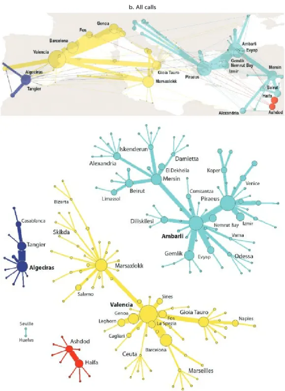
As Mediterranean shipping centralizes services, it is becoming more uniform and offering fewer alternatives for main port calls. The share of intra- Mediterranean traffic (that is, to ports within the Mediterranean) in total Mediterranean traffic is increasing, with the majority of intra-Mediterranean traffic going between European ports (mainly east–west). Subnetworks also show a strong east–west divide, with Piraeus–Ambarli (Turkey) and Marsaxlokk (Malta)–Valencia (Spain) the respective central nodes.
Yet the Mediterranean’s regional shipping integration is looser than that in more mature areas, such as Northern Europe and North America’s East Coast. Expansionwise, some port clusters are showing fast growth around straits, while time efficiency (measured by vessels’ average turnaround time) for Mediterranean ports is generally improving, though it is declining for some.
GEOGRAPHIC PATTERNS IN THE MEDITERRANEAN
Large ports are more central, often perform better on average ship turnaround time, and are closer to the trunk line than are smaller ports. Extra-Mediterranean traffic and alliance traffic are also key (but not determining) features of most large ports. Algeciras (Spain), Marsaxlokk (Malta), Tanger Med (Morocco), Sines (Portugal), Damietta (Egypt), and Cagliari (Italy) are among the largest and most central ports and are better located but less attractive to alliances. Ambarli (Turkey), koper (Slovenia), and Trieste (Italy) are more peripheral but have a higher share of alliance traffic, though their role is more local, and they act as gateways.
Ports situated at the edge of the Mediterranean, such as those along the Strait of Gibraltar and the Black Sea, perform better globally (at the world scale) than locally (at the Mediterranean scale), on the basis of betweenness centrality, because their local centrality within the Mediterranean is cut off. Very few ports perform better locally than globally.
PORT EFFICIENCY
Ports make the link between global or regional shipping networks and economic activities in the hinterland. Thus trade connectivity is influenced by how ports handle the supply chain that goes through them. Efficiency in connecting the hinterland to the global market is not easily captured by simple performance indicators such as container throughput or crane productivity. Nor are globally comparable indicators available, except for service time for container ships (see chapter 1).
A case study of Spain shows how port efficiency (specifically port market share) is related to maritime networks and hinterland connectivity from the per-spective of supply chain operators. After seven indicators related to port impor-tance and competitive advantage, connectivity between the hinterland and the port, and connectivity between the port and the destination were analyzed, road distance and throughput volume were found to be the main factors in determin-ing a port’s market share. For Spain the likelihood of choosdetermin-ing a port is halved for every 150 kilometers that it is away from the hinterland (see chapter 4).
HINTERLAND CONNECTIVITY
Getting a container to or from a port can be as costly as shipping the container to or from its overseas destination or origin. Although maritime container tariffs have fallen dramatically with the introduction of larger container vessels, hinter-land access costs have not. As the opportunities for increased market share and growth through improved maritime connectivity are exhausted, ports are
focusing on competitiveness, market share, and economic growth through improved hinterland connectivity. But knowing what the hinterland is and how well it is served has generally been subjective. Objective data on hinterland size and access to ports and on the modal split and intermodal connectivity of that access are becoming more important for ports that are seeking to increase demand through lower transport costs and shorter and more-reliable access time. A change in port access can allow countries both to reap the social and environmental benefits of rail and inland waterway barge transport and to reduce pressure on congested access roads. The current share of rail to most Mediterranean ports is zero or close to it, and the number of rail services that expand the hinterland to other countries is even lower (see chapter 3).
A port authority or port development company can expand its hinterland by increasing the attractiveness of intermodal transport. Initiatives include devel-oping partnerships with inland ports, providing new services, and securing inter-modal connections between the various terminals in a port. Tanger Med, Morocco (and Port Said East, Egypt, less so), show that shifts in hinterland cargo between ports occur only gradually and require major investment in landside infrastruc-ture. Increased import–export traffic can also help attract export- oriented industrial activities to the port region, spectacularly as with Tanger Med.
The first step to implementing these measures is to address the paucity of data. Few ports publicly report the inland origins and destinations of their con-tainers, the share of containers that are transported by each mode, or data on intermodal connectivity. But recent advances in automated data collection and processing have a huge potential for better measurement of container movement through the hinterland.
IMPROVING CONNECTIVITY
Maritime networks and hinterland connectivity, together with port efficiency, contribute to a port’s overall connectivity and competitiveness—not only from the perspective of port operators, but also from the perspective of actual and potential shippers, those responsible for managing economic and trade growth, and opera-tors and managers of transport and logistic networks and services (see chapter 5). The major challenge in turning better connectivity into economic benefits is to integrate the development of shipping routes and ports with logistics, free-trade, and industrial zones—and more generally with hinterland connectivity. Such development requires good governance and a holistic approach to the three dimensions of connectivity. A development model in which multiple enti-ties make decisions on the basis of their own sphere of influence is unlikely to be effective.
Given the economic benefits of better connectivity for port users and for soci-ety at large, policy makers, port managers, and shipping companies are all active in policies and strategies to improve connectivity. While each group can act inde-pendently, coordinated actions are more productive.
Patterns of port developments and connectivity
There are three interrelated port development strategies, each of which priori-tizes one of three markets that a port can serve—transshipment,1 the hinterland,
Although the strategies rely on different mechanisms, the outcomes are sim-ilar. For example, more maritime connectivity from transshipment is a platform to expand the hinterland but requires infrastructure and services (figure ES.2). An expanded hinterland or captive cargo base turns a port into a must-call des-tination. A port with a favorable location in maritime networks and decent capacity and terminal productivity can attract additional transshipment. Better overseas and hinterland connectivity increases the attractiveness of a port for logistics and manufacturing activities, which also require the location to have solid fiscal performance, a strong labor market, and high scores for ease of doing business. A strong captive cargo base provides a basis for expanding the hinter-land. Flows directly to the hinterland can be combined with flows generated by local logistics and manufacturing activities. This creates scale economies, espe-cially if rail or barge transport is used. In addition, the economic benefits of infra-structure that connects the port to the hinterland are larger if that infrainfra-structure is used both for transit cargo and for cargo related to the local logistics and man-ufacturing activities.
Transshipment flows can be attracted relatively quickly because shipping companies can shift traffic from one port to another without major infrastruc-ture investments (beyond a container terminal with enough storage space). Transshipment is rather footloose, especially given the intense competition among numerous hub ports in the Mediterranean. So ports can attract traffic in a short time span but can also lose it in a short time span. A partnership in which a shipping company takes a substantial share of investment in port infrastructure can reduce this volatility.
In contrast, expanding the hinterland generally requires investment in road and rail infrastructure (and in inland waterways for some ports) and thus takes longer to increase connectivity than attracting transshipment traffic does. These investments are generally time-consuming to plan and implement. In addition, shifts of hinterland port traffic do not happen spontaneously or instantaneously: existing supply chains often persist, because switching entails high costs.
Similarly, expanding the captive cargo base is a lengthy process because it requires developing land for logistics and manufacturing, attracting customers FIGURE ES.2
Three port development paths and strategies
1. Hinterland expands, with more
maritime connectivity, from transshipment activity and/or when inland destination benefits from the economies of scale of a strong captive cargo base.
2. Captive cargo increases as better
maritime and hinterland connectivity expand the market potential of logistics and production activity in the port vicinity.
3. Transshipment develops as
hinterland and/or captive cargo activities expand because the port becomes more attractive to call at for shipping lines. Increase captive cargo base Expand the hinterland Attract trans-shipment flows 1 1 2 2 3 3
Note: Does not include non-port-related interventions such as investment in maritime safety and
to lease or buy that land, and investing in freight capacity. Many ports that start from a local cargo base are in the downtown area of a port city, where land for expansion is scare or expensive. Only after investment in satellite facilities (such as dry ports and logistics zones) and access routes are realized will logistics and manufacturing operations attract additional traffic to the port from inland locations.
A typology of ports by connectivity and development strategy
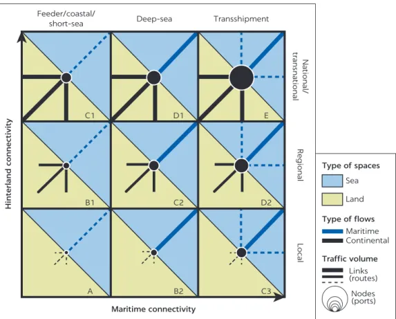
Port development is both place-dependent (meaning that it depends on starting point—as a transshipment port, a port focused on the hinterland, or a port depen-dent on a strong cargo base) and path dependepen-dent (meaning that it depends on which strategy is prioritized). The preferred strategy for a port depends on its location on two axes of development—hinterland connectivity and maritime connectivity (figure ES.3).
Growing one or both dimensions will increase traffic (indicated by size of the circle in the center). Cell A represents a typical cargo-based port, with a short hinterland connection (indicated by the dotted line in the left of the cell) and only secondary maritime services to other ports, some of which are feeder services to hub ports (indicated by the dotted line in the right of the cell). This type of port represents many ports that have a long history based on serving just the city and metropolitan area in which they are located. Path A→B2→C3 in figure ES.3 shows a development strategy focused exclusively on transshipment,
FIGURE ES.3
Typology of port connectivity
Sea Land Type of spaces Maritime Continental Type of flows Links (routes) Nodes (ports) Traffic volume Hinterland connectivity Maritime connectivity Feeder/coastal/ short-sea Deep-sea C1 B1 B2 A C2 C3 D1 D2 E Transshipment National/ transnational Regional Local
with maritime services evolving from direct and feeder services (A) to one with some transshipment (B2) to one with transshipment and its own feeder services (C3). Path A→B1→C1 shows a development path focused exclusively on hinter-land connectivity (including the cargo base), with the hinterhinter-land evolving from (A) to an expanded cargo base (B1, with a heavier land connectivity line) to expansion in the hinterland beyond the cargo base (C1).
A port that already has a cargo base (B1 in figure ES.3) and aims to develop transshipment service would add some transshipment services (C2) and ulti-mately have a stronger cargo base and more balanced demand (D2) than a pure transshipment port.
A pure transshipment port (C3 in figure ES.3) that focused on hinterland development would evolve towards (D2) and then (E), while the most balanced profile (C2) could follow the same path but from a different initial configuration. The (D2) type is more specialized in maritime flows but improves its hinterland connectivity when evolving from (C3) and attracts transshipment activities when evolving from (C2). By contrast a pure cargo base and hinterland port (C1) focused on transshipment would attract more direct calls from shipping lines or deep-sea services (D1) and eventually become a fully-fledged transportation hub with both sea–land and sea–sea transshipment in addition to serving the expand-ing local cargo base (E). The type (E) can be considered the ultimate stage of development for any port, but many factors come into play that can, after reach-ing a critical mass, cause connectivity losses on either the hinterland or maritime side (such as congestion, handling costs, lack of space, and port competition and selection). Reverse trajectories are thus also possible.
POLICY RECOMMENDATIONS
General
• Maritime networks, port efficiency, and hinterland connectivity not only con-tribute to the market shares of a port with shipping lines; they might also be tied to its economic role and the size of its hinterland. The physical fragmen-tation of the Mediterranean territories makes expansion beyond the cargo base difficult, and competition between port hinterlands can make further hinterland expansion difficult. Most ports that depend primarily on trans-shipment services aim to build on their maritime connectivity advantage and develop a deep hinterland but rarely meet these objectives.
• The benefits of physical investment in ports and associated investment in land access depend partly on interventions by policy makers not only in ports, but also in other areas such as industry and trade. Improving connectivity and maximizing its economic benefits through trade and investment should be core policy objectives. Any development project should be rooted in and envisaged through an integrated port cluster strategy.
• A consistent approach to improving connectivity and to creating trade oppor-tunities requires review of maritime networks, port efficiency, and hinterland connectivity. For Mediterranean ports with limited scope for increased hin-terland penetration, widening maritime networks and increasing port effi-ciency are the main ways to boost overall competitiveness.
• Policy makers need to consider improvements in maritime networks, port effi-ciency, and hinterland connectivity to be interdependent. National policies
have little direct leverage on maritime networks, which are driven largely by the strategies of global shipping lines, but can affect port efficiency or hinter-land connectivity, which could in turn influence maritime networks. One potential strategy is to attract vertically integrated shipping companies that are also involved in inland logistics and terminal operations.
• Port development strategies are often part of a national trade development strategy. Although the link between maritime networks and hinterland con-nectivity have been demonstrated, more research is needed to better under-stand the links and causations among maritime networks, port efficiency, hinterland connectivity, and trade outcomes.
• Successful strategies of port expansion are usually location and path specific and cannot simply be transposed to or replicated at another port. To pursue an optimal port development path, policy makers need to take into account local, regional, and national considerations—and even historical and cultural ones. The strategies indicated here provide a framework that includes mari-time networks, port efficiency, and hinterland connectivity, within which more-specific port development paths can be determined.
Maritime networks and port efficiency
• Mediterranean container ports show clear economies of scale, as evidenced by those in Spain. Volume is also closely related to higher maritime connectivity—scale economies partly explain the increasing concentration of shipping line calls in the Mediterranean. To take scale economies into account, policy makers could focus on one or a few core ports and core corridors. Cross-border cooperation between ports and countries should also be envisaged to avoid overcapacity.
• From the perspective of trade connectivity, port efficiency requires port reform (involving the landlord, operators, and shipping lines) and trade facil-itation (customs, border agencies, and freight forwarders). A good balance and dialogue are necessary between global and local players, but bringing in global alliances might not yield immediate benefits unless the alliances are well integrated with the local port community.
• Policy makers are generally aware of where applying best practices could do the most to improve the efficiency of gateway ports (port management reforms and trade facilitation). However, outcomes of the application of best practices vary greatly across Mediterranean countries and ports—with North African ports benefitting the least.
• Given the importance of all three dimensions of trade connectivity in increas-ing port competitiveness, more data on connectivity—includincreas-ing data on port efficiency and hinterland destinations of containers—are needed to ensure efficient and effective application of best practices. And improving the com-parability of data across ports requires partnerships among providers of con-nectivity data and cross-border cooperation.
• Roll-on, roll-off services generally complement container services, because roll-on, roll-off is faster and generally does not entail transshipment. To be comprehensive, development strategies should go beyond container connec-tivity to include maritime connecconnec-tivity through roll-on, roll-off services. Balanced development of port maritime networks would take into account regional and local connectivity, as through short-sea and coastal shipping, as well as roll-on, roll-off and global maritime connectivity.
Hinterland connectivity
• Policy initiatives targeting the hinterland are needed to boost the impact of maritime networks, especially improving the value of transshipment hubs for national and regional economies. Otherwise transshipment supports only offshore activities, with few economic links to the hinterland
• Development of hinterland connectivity is most efficiently pursued through a regionalization strategy based on inland port development and value-added logistics
• Captive cargo bases can best be implemented through policies that have both hard and soft components. Such policies include those that focus on develop-ing logistics and trade-oriented manufacturdevelop-ing clusters (such as special eco-nomic zones) that are well-linked (if not adjacent) to the port complex. and those that focus on improving hinterland access, as is being done in Tanger Med, Morocco (and is being attempted in Port Said, Egypt)
• Getting hinterland governance right is critical for developing logistics and trade-oriented manufacturing clusters near ports. Tanger Med (Morocco) is close to being a best-practice port where an integrated development approach has worked well (in contrast to Port Said East, Egypt, where a nonintegrated approach has failed to add hinterland trade to an otherwise successful trans-shipment port). Even in successful cases, integrated development is a long-term endeavor
• A hinterland expansion strategy depends on infrastructure and logistics net-works, preferably with rail and road connections, which can bring about the seamless supply chain connections that are essential for success
• Of concern in the Mediterranean is the lack of intermodal connections. Compared with other regions in global trade (East Asia, North America, and Northern Europe), most Mediterranean ports, especially those outside the European Union, have limited or no intermodal connectivity for moving con-tainers to and from their cargo base or hinterland. A small number of ports, some within the European Union, have less need for intermodal connectivity because of their insular location (for example, Marsaxlokk in Malta), but these are exceptions. Barcelona, and to a lesser extent Marseilles, show how attention to intermodal connectivity can increase penetration of a hinterland that faces strong competition from other ports. Improving intermodal con-nection extends and connects the hinterland and spreads the economic ben-efits of international trade to inland regions that are otherwise too remote from a port to participate.
NOTE
1. This market can be further segmented into interlining (transfer of containers between mother vessels at the crossroads of the trunk line) and hub-and-spoke (transfer of contain-ers between mother vessels and feeder ships within the region).
xxvii ARD all-road distance
GDP gross domestic product HHI Herfindahl-Hirschman Index IHS Information Handling Services MFD maritime feeder distance PC port costs
TEU twenty-foot equivalent unit VMC variable maritime costs VRC variable road costs
1
Drivers of Trade Connectivity
in the Mediterranean
During the Roman Empire, Mediterranean ports brought traded goods from Rome’s provinces, according to their resources, to Rome and other places of con-sumption (map 1.1). A maritime network centered on Ostia (Rome’s port) sup-ported this trade. The main nodes in this port system were well linked to their provinces through Roman roads or waterways.
Although today’s Rome no longer has a major commercial port nearby, many of the old nodes remain important ports—Alexandria, Barcelona, Carthage (Tunis), Istanbul, Marseilles, and Piraeus (Athens)—that serve wide hinterlands. The precise locations have often shifted to allow modern facilities to be built.
Shipping intensified in the 19th century with the advent of steam and the opening of the Suez Canal, which made the Mediterranean the primary transit route between Europe and Asia. Containerization in the latter part of the 20th century again changed trade patterns, with maritime networks working increas-ingly through transshipment hubs, major gateways, and feeder ports.1
This chapter presents an overview of networks and geographic areas in the Mediterranean region, puts forward a tripartite conceptual framework, consid-ers indicators useful in measuring trade connectivity and the efficiency of the Mediterranean’s major ports, and briefly reviews some drivers of trade connectivity.
THE MEDITERRANEAN: THE NEXUS OF WORLD TRADE OR
ITS OWN SMALL WORLD?
The Mediterranean today is not a quasi-independent network as it was in antiq-uity but a major link in the global trade system (map 1.2). The maritime networks in the Mediterranean are structured according to the sea’s internal geography and the locations of the main hubs and gateways (map 1.3).
The huge number of ships transiting through the Mediterranean heavily influences the shipping routes in the Mediterranean (see map 1.3). The route toward the Suez Canal is not the biggest for the Mediterranean. Around 70,000 ships a year pass through the Strait of Gibraltar, compared with about 18,000
MAP 1.1
Trade routes in the Roman Empire
Source: Scheidel and Meeks 2012. This work is available under the Creative Commons Attribution 3.0 IGO license (CC BY 3.0 IGO). Note: Green lines refer to coastal routes, blue lines refer to open sea routes, brown lines refer to land routes, and purple
lines refer to river routes.
MAP 1.2
Global trade flows, 2009–16
Major flows (in millions TEU)
Source: Produced by Justin Berli (Centre national de la recherche scientifique) and Mattia Bunel (Institut national de
through the Suez Canal, underlining the large number of ships from the Mediterranean to, for example, the Americas, Northern Europe, and west Africa. Huge numbers of ship movements are purely within the Mediterranean. The imbalance in ship movements is huge between the northern coast of the Mediterranean (Europe) and the southern coast (Africa), with many more along the European coast because of higher population density and greater economic development (see map 1.3).
for container shipping the Mediterranean’s transit role leads to maritime networks with hub ports with low diversion distances (the deviation required from the transit route and feeder ports elsewhere in the Mediterranean; map 1.4). MAP 1.3
Shipping patterns in the Mediterranean, 2009–16
Source: Produced by Justin Berli (Centre national de la recherche scientifique) and Mattia Bunel (Institut national de
l’information géographique et forestière) based on data from Lloyd’s List Intelligence (see annex 2A). MAP 1.4
Shipping routes and diversion distances in the Mediterranean, 2015
Deviation from main shipping route 250 nautical miles 100 nautical miles
Source: Adapted from Rodrigue, J-P and T. Notteboom (2010). Note: Orange circles indicate transshipment traffic.
Hub ports are more diversified than gateway ports in foreign ports to which they are connected because of hub ports’ transshipment function.
for ports in the Mediterranean, proximity to major shipping routes is an opportunity. Attracting transshipment traffic has a positive effect on a port’s maritime connectivity by reducing trade costs and boosting trade. Connectivity also increases a port’s attractiveness as a location for logistics value-added ser-vices, such as warehousing, repacking, light assembly activities, and customizing. for these reasons policy makers are keen to develop large deep-sea container terminals.
The Mediterranean: port and shipping routes
The geographic area of the Mediterranean includes the sea itself as well as Atlantic ports in Morocco (such as Casablanca), Portugal (Sines), and Spain (Bilbao and Corunna), because they share the same hinterland. The English Channel and the North Sea, the Black Sea, and many Middle Eastern ports are closely connected to the Mediterranean and are included as external partners.
The Mediterranean is naturally divided into two basins, western and eastern, separated by the Strait of Sicily. The western basin serves Algeria, southern france, Italy, Morocco, Spain, and Tunisia; its main gateways include Barcelona, Genoa, Marseilles (fos), and valencia (Spain). The main ports in the eastern basin are in the Arab republic of Egypt (Alexandria), Greece (Piraeus), Israel, lebanon, the Syrian Arab Republic, and Turkey. Seventeen major Mediterranean ports are briefly described in the appendix A. Major transshipment hubs are at the Strait of Gibraltar or relatively close by (Algeciras, Spain; Tangier, Morocco; and valencia, Spain); at the junction of the two basins (Malta and Sicily); and at the Suez Canal (Port Said, Egypt; see map 1.3).
Hinterland
Hinterland is the traditional term for the area of logistics and economic influ-ence of a port or more generally a trade gateway.2 On the southern rim the
hin-terland of the main port gateway is almost always delimited by national boundaries: the main entry points are Alexandria for Egypt, Algiers for Algeria, Casablanca for Morocco, and Radès for Tunisia. Transit across borders is very rare, with only a little from Tunisia to its neighbors.
The hinterlands of the main gateways heavily overlap in the western Mediterranean and compete with the major entry points to the European Union—Antwerp and Rotterdam. Ports in Greece and the western Balkans tend to serve their own countries but are extending their zones of influence into the landlocked countries of Central and Eastern Europe.
TRADE CONNECTIVITY AND ECONOMIC DEVELOPMENT
Trade connectivity captures the structure, spread, and efficiency of global ser-vices networks that enable access to markets and to opportunities. Countries and regions are increasingly identifying it as a key factor in achieving trade compet-itiveness and sustainable, inclusive economic growth.The One Belt, One Road initiative, led by China and targeting more than 60 countries, seeks to improve trade connectivity among former Silk Road economies (the Belt) and countries on the main sea routes from China (the Road) to Europe, including the Mediterranean. Still in development, this ambitious program will target physical infrastructure in multiple loca-tions and aims to catalyze finance and investment. The Mediterranean Sea is part of the road. Even before One Belt, One Road, Chinese operators had growing influence over ports and maritime activities in the countries of the Belt, further underlining the global reach of shipping and logistics compa-nies in China. for instance, Chinese operator COSCO has redeveloped the Piraeus gateway.
The Mediterranean lacks a trade connectivity initiative in such a format. The Union for the Mediterranean,3 founded in 2008, is arguably an initiative of this
type, to encourage economic links among countries along the rim. The secretar-iat of the union is not a funding agency; it is a small structure whose role is to advocate and facilitate, through coordination of countries and financing organi-zations, important cross-border projects that do not fall the under the responsi-bility of a single country. The European Commission has extended the transport corridor concept to maritime routes. This initiative is called Motorways of the Sea, and it was proposed as a competitive alternative to land transport for routes linking non-EU countries to European Union (EU) countries in the Mediterranean. It aimed to introduce new intermodal maritime-based logistics chains in Europe in order to improve transport organization (Commission of the European Communities 2001).
Trade connectivity integrates many dimensions and scales: countries in the global economy and regions in countries. Trade, information, freight, logistics, energy, and financial networks all interact. Connectivity is as much about physical connections as it is about services, and it thus depends on policy and investments. At the national level good trade connectivity to hubs of global economic activity is critical to integrating regional and global trade and value chains. Connectivity is enhanced by removing trade barriers and reducing trade costs. At the subnational level regions disconnected econom-ically from dynamic economic centers—but not necessarily geographeconom-ically distant—have higher trade costs and do not realize market opportunities. Poor links inhibit economic potential and contribute to lower socioeco-nomic outcomes.
Several researchers (including Jean-Paul Rodrigue and César Ducruet) have studied the relationship among maritime networks, their growth, and their influence on hinterland development. The networks are highly complex systems with many places, modes of transport (bulk; container; roll-on, roll-off ), types of services, and regulatory agencies. A natural way to approach this complexity is to look at it from the perspective of the supply chain—and that of a trader or manufacturer in a single Mediterranean country. The supply chain setup with overseas markets (regardless of whether they are also in the Mediterranean) includes logistics in the foreland (that is, in inter-national waters), the logistics at a gateway port, and the logistics system in the hinterland.
Trade connectivity is therefore viewed here along three dimensions: mar-itime networks, which refers to the structure and performance of shipping networks before the gateway; port efficiency, which refers to the
performance of the gateway (a port or group of ports sharing the same hin-terland); and hinterland connectivity, which involves multiple players and institutions contributing to economic development and exploiting maritime supply chains (figure 1.1). All three dimensions explain how economies take advantage of their position in global and regional networks (roughly, what connectivity is about).
A distinction can be made between the hub function and the gateway func-tion of a port. The hub funcfunc-tion entails a role as transshipment center, where containers arrive by ship and are loaded on another ship. The hub function includes relay traffic, the transfer of containers from one intercontinental service to another (for example in Tanger Med, Morocco, containers on the Asia–Europe trade route are transshipped to the Europe–west Africa trade route) as well as feeder traffic, the delivery of containers to nearby feeder ports, generally with smaller vessels (for instance, containers from Asia are transshipped in Algeciras, Spain, and feeder ships bring the containers to destination ports such as Malaga and Seville). The gateway function is when a port serves as the entrance and exit of merchandise in a region, country, or group of counties.
Some ports combine the hub and gateway functions (the best examples in the Mediterranean being Piraeus and valencia, Spain), other ports are essentially hubs (Algeciras, Spain; and Tanger Med (Morocco), and still others are essen-tially gateway ports (Casablanca and Marseille).
There is a fundamental difference between the requirements for hubs and for gateways. Hubs require an efficient container terminal because contain-ers do not leave the fences of the port and customs-related processes are rarely a constraint. By contrast, gateways require a full range of transport and logistics services and efficient hinterland connections to perform effi-ciently. Therefore, a gateway port can attract hub traffic if it is well located in maritime networks and can attract an anchor shipping company with hub operations in the port. Such a development creates value for the shipping company and terminal operator but has little direct impact on the economic FIGURE 1.1
Three dimensions of trade connectivity
Physical networks
Soft and hard infrastructure Indicators Supply chain, logistics performance indicators Port performance and port logistics indicator Network metrics Hubs and spokes Maritime
connectivity efficiencyPort
Port(s) system Hinterland connectivity Logistics facilities Economic zones Services Institutions