HAL Id: hal-00801655
https://hal.archives-ouvertes.fr/hal-00801655
Submitted on 18 Mar 2013
HAL is a multi-disciplinary open access
archive for the deposit and dissemination of
sci-entific research documents, whether they are
pub-lished or not. The documents may come from
teaching and research institutions in France or
abroad, or from public or private research centers.
L’archive ouverte pluridisciplinaire HAL, est
destinée au dépôt et à la diffusion de documents
scientifiques de niveau recherche, publiés ou non,
émanant des établissements d’enseignement et de
recherche français ou étrangers, des laboratoires
publics ou privés.
Developing and integrating a simulation model of water
resources supply and demand within an on-going
governance building process : a case study in Thau
Catchment, South of France
G. Abrami, A. Richard-Ferroudji, S. Barone, O. Barreteau, C. Tessier
To cite this version:
G. Abrami, A. Richard-Ferroudji, S. Barone, O. Barreteau, C. Tessier. Developing and integrating
a simulation model of water resources supply and demand within an on-going governance building
process : a case study in Thau Catchment, South of France. 2012 International Congress on
Environ-mental Modelling and Software, Jul 2012, Leipzig, Germany. p. 1903 - p. 1911. �hal-00801655�
R. Seppelt, A.A. Voinov, S. Lange, D. Bankamp (Eds.) http://www.iemss.org/society/index.php/iemss-2012-proceedings
Developing and integrating a simulation
model of water resources supply and
demand within an on-going governance
building process : a case study in Thau
Catchment, South of France.
Géraldine Abrami1, Audrey Richard-Ferroudji1, Sylvain Barone1, Olivier Barreteau1 and Camille Tessier1
1
Cemagref / Irstea – UMR GEAU – name.surname@irstea.fr
Abstract : A companion modeling process about water resources supply and
demand at the scale of a catchment in partnership with the catchment management institution and with intermediary level stakeholders of the different sectors of water use, production and distribution in the territory is being held in the Thau catchment, near Montpellier in South of France. This companion modeling process has been shaped by both a scientific questioning about interactions between land and water dynamics and governance within a catchment and the history of collaborations between the research team and the case study partners. It was initiated by the catchment management institution’s request to our team for a methodological support during a prospective exercise within the catchment management plan development process. It was then agreed to keep on collaborating through the development of a computer aiming at supporting a real joint reflection on the integrated management of land and water resources of the territory. During a first phase, causal maps were used for developing and discussing individually the conceptual model with the stakeholders. The objective was to elicit and discuss which variables we should consider and how they are linked. We ended up with a conceptual model where the complexity was not arising from feedback loops between variables but from the interlinkage of differentiated decision-making centers, resources and management entities. For this reason, we’ve shifted to agent-based modeling and implemented our simulation model under Netlogo. A first stakeholders’ workshop for validating the simulation model and discussing stakes and scenarios was held in March and this companion modeling process has been institutionalized as an official action of the newly born catchment integrated management contract.
Keywords : Thau, companion modeling, integrated water management, land
planning, water resources planning
1 INTRODUCTION
The work presented in this paper reports an on-going research-action experience which uses companion modelling as a way to mediate interactions between and within a research project and the water resources management plan building process of the Thau lagoon territory in South of France. The objective of this experience is to enrich reflexions and decision-making within a stakeholders’ workgroup about the catchment water resources through the design and exploration of a simulation model questioning the co-evolution of water resources supply, driven mainly by climate, regulation and water infrastructures development, and water resources demand, driven mainly by land planning, agricultural policies
G. Abrami et al. / Developing and integrating a simulation model of water resources…
and consumers behaviours. This work is conducted in close collaboration with the Thau catchment management institution within the French Environment Ministry founded research project SURGE. The SURGE project focus is about analysing and qualifying existing, possible or desirable water related interdependency relationships between urban and rural parts of a territory. Some publications about this project include Bots et al (2007) and Barreteau et al (2010).
Companion modelling (Voinov and Bousquet, 2010; Barreteau et al, 2003a; Bousquet et al, 2002) has been used quite extensively in the last 15 years in many fields of natural resources management. Companion modelling is a research-intervention approach where model building and simulation with stakeholders is used in iterative cycles to foster discussions and exchanges around a shared representation, the model. Companion modelling experiments dealing with water resources planning include for instance Farolfi et al (2010) in South Africa or Gurung et al (2006) in Bhutan or Barreteau et al (2003b) in France. Other examples of research driven modelling for supporting land and water planning can be found in Metcalf et al (2010) and Sampson et al (2011). The originality of the work presented in this paper lies in the joint consideration of land and water dynamics considering individual particularities of the different water resources and divisions of the territory, both in the model and in the planning process, as well as in the long-term trust building process between the research team and the water plan manager. A result is that when the SURGE project ends, the process will carry on as a founded action of the newly established Thau Integrated Management Contract.
The Thau lagoon is a large Mediterranean lagoon (7000 has) stretching on the Languedoc-Roussillon coast in South of France, 30 km from the regional capital, Montpellier. The lagoon is one of the main oyster production places in France, and the dependency of the catchment economic activities on the environment quality has been acknowledged for a long time. Quite uniquely in France, The Thau catchment is equipped with a single institution (SMBT – Syndicat Mixte du Bassin de Thau) that conducts jointly an integrated water management plan (SAGE – Shéma d’Aménagement et de Gestion des Eaux) and an integrated land management plan (SCOT – Schéma de COhérence Territoriale) at the scale of the catchment. As a result, the Thau catchment is promoted as an exemplary case of successful coastal area integrated management: for instance a field trip to “The Thau lagoon: an exemplary integrated management in the Mediterranean” was part of the animations of the 2012 Marseille World Water Forum1. However the political context and the history of water management in the area is more complex than the success story narrative (Barone et al, 2010) and the water resource issue in the area is very sensible. It is worth mentioning here that what makes the water resources issue in the Thau catchment rather tense and uncertain: 1. the superficial water bodies of the Thau catchment are scarce and are not used as water resources in the catchment; all consumptive uses of water in the territory rely either on aquifers which dynamics are fragile or not well known, or on the importation of external water resources. 2. The domestic needs pressure is important due to a demographic growth context driven by the dynamism of the neighboring regional capital and to an important mass tourism activity which may triple the population of the catchment during summer.
For 20 years, the Thau area has been quite a scientific playground but studies and management plans have focused mainly on water and environment quality issues. As a result, a subsequent amount of work has been made on modelling or monitoring the ecological dynamics within the lagoon (Chapelle et al, 2000; Plus et al, 2006; Trousselier et al, 2001), or on integrated modelling of water quality and socio-economics dynamics in the territory (Guillo et al, 2002; Tournoud et al,
1111111111111111111111111111111111111111111111111 1
http://www.worldwaterforum6.org/en/news/single/article/the-thau-lagoon-an-exemplary-integrated-management-in-the-mediterranean/
2006). On the contrary, water resources supply issues have only recently really emerged as a matter of concern at the catchment scale and although there is a large amount of scattered gray literature and data, the only effort of integrated modelling on the subject within a research project was made 10 years ago in the DITTY project, where a system dynamics model of the quantitative water cycle was built (Celse et al, 2006).
The objective of the paper is to give insights on the evolution of modeling choices all along the process and the organization of interactions with and between stakeholders around the model. It will first relate the different stages of the companion modeling process in Thau, then it will describe the resulting model in its current stage and finally discuss modeling choices and remaining issues as well as future work developments.
2 THE THAU COMPANION MODELLING PROCESS
The SMBT and our research team have been collaborating for several years within several research projects. For instance Maurel et al (2007) relates how the early phases of the land management plan process where supported with different ICT tools including a physical scale model of the catchment. Based on this trust-building capital, the companion modeling process about water resources in the Thau catchment was initiated in the spring of 2010.
2.1 Process initiation: building the local partnership
The initiation of this companion modeling process relies on a collaboration opportunity between the SURGE project and the SMBT that emerged after several months of difficulties of defining a proper issue with the proper partnership within the research project. In early 2010, our research team was asked by the SMBT to support the scenario building phase of the water management plan by organizing a series of participatory prospective study workshops. These workshops resulted in the production of 3 narrative scenarios and 13 thematic sheets describing the main change drivers of the territory: external drivers (national regulations, climate change), resources and productions (demographics, urbanization, water resources, sanitation, transport, waste), economic activities (agriculture, fishing and shellfish farming, industry, tourism and thermatology). With the success of this exercise, the SMBT became willing to engage further in exploring possible futures. The initial idea was to engage within a participatory modeling exercise which objective would be to define more formally the interdependencies between the 13 change drivers and produce simulations of how their co evolution could impact on the system. For the research project, this was the opportunity to upscale the local partnership of the project at the catchment level with the legitimate water management institution. For the SMBT, this was an opportunity to get support for pointing and addressing tricky issues in the strategy building phase of the water management plan.
2.2 First round of modeling exercises: defining a focal issue
The modeling exercise was initiated with the question: “how may the evolution of the driving factors identified during the prospective study workshops interact with the quality and quantity of the water bodies of the territory?”. The 13 thematic sheets were presenting qualitative and quantitative information structured with the following rubrics: variables the driver may be dependent on, impacts on the water bodies, interdependencies link with the other drivers, indicators and potential evolution scenarios. Our approach was to build a conceptual model basis sticking as much as possible to the content of the change drivers sheets for a start. Given this systemic structuring, each sheet was translated into a causal map. The resulting conceptual model was used as a basis to interact with the water management plan leader during the summer of 2010.
This first conceptual model was a formalized view of the full range of interactions between land and water in the Thau catchment. It was useful for conducting a prospective exercise but we acknowledged with our partner that the issue was too broad for driving properly a companion modeling exercise. In Thau, water
G. Abrami et al. / Developing and integrating a simulation model of water resources…
management has historically been driven by quality issues. Public discussions about quantity issues can be traced back in 2006 during the land management planning process initiation and focus essentially on domestic water and demographic tensions. The water resource has always essentially be a technical issue and it is only in very recent years that issues about raw water and irrigation water emerged, and that voices raised to ask clarification about uncertainties and contradictions about the water resource supply and needs projections, notably with the public debate about the Aquadomitia project2.
Our companion modeling exercise appeared to the SMBT as a good opportunity to get support on carrying the issue to a more open and political debate around integrated water resources management. As a consequence it was decided with SMBT that the companion modelling process will focus only the issue of water resource.
2.3 Second round: refinement, data collection and prototype building
The new question was « how may the various scenarios of land and water planning impact on the water resources use level and users satisfaction, and at which costs ? ». A new conceptual model was built them in collaboration with SMBT by selecting only the maps related to water resource supply and demand and refining until getting to a satisfying point of description of the parameters, variables and processes. After having agreed on this conceptual model, time was spent with the key stakeholders knowledgeable for our issue in individual interviews about the model content and the missing information and data.
A first prototype for a simulation tool was developed on this basis. It is not yet completely functional but it has already fulfilled his role of strengthening the formalization of our conceptual model: identification of the hidden hypotheses, identification of knowledge gaps still remaining, proposition of scenarios and indicators.
2.4 Third round: launching of an institutionalized collective process
With our research project getting close to its end, the SMBT decided to institutionalize this collective modelling and simulation process within a founded action of the Integrated Management Contract of the Thau territory, which objective is to settle founded and precise actions to implement an integrated governance over land and water in the territory and with the interconnected catchments. This action called “development of a tool for concerted management of water resources and needs on the Thau territory” was officially launched in March 2012 with a meeting gathering 15 stakeholders representing all the relevant institutions that have to deal with the issue. The objective of the meeting was to institute this workgroup as a steering committee of a modelling and simulation prospective exercise about the issue of water resources of the Thau territory that will be carried on during the year and a half to come. During the meeting, the model use as an exploratory dynamic tool and the model content were presented and thoroughly discussed against the expectations and knowledge of the workgroup members. The prototype was presented through a systematic but synthetic description of the entities, hypothesis, scenarios, indicators and issues for each module. This was successful in generating in nice and lively discussions about what is missing, which data we should use and which question exactly we want to focus on.
All the stakeholders acknowledged the interest of the approach and understood that the tool we are providing will be an ever evolving and non predictive one. They also acknowledged that the urgent need was to define a very precise stake for the tool so that it is focused and does not try to represent everything. Finally they agreed on the next steps of the process. After having collected the stakes and expectations of the workgroup and worked on a prioritisation with the water management steering committee, we will spend the summer finalizing the data collection and prototype specification according to these priorities. Then in
1111111111111111111111111111111111111111111111111
2
Aquadomitia project is a controversial project supported by the regional government about connecting the region to the Rhone river with a massive pipe
September this work will be discussed and validated again by the workgroup so that the model can be finalised and the scenarios exploration can start during winter. Then in 2013, we will start a specific work on the economic components and indicators in the model.
3 The model of water resources supply and demand in the Thau territory 3.1 The conceptual model
The conceptual model presented in this paper is the one that was presented to the workgroup in March 2012. It results from the direct interactions with the Thau water management plan leader and from the analyses of the interviews with the stakeholders. In order to compel with the joint land and water management policy of the territory, it represents jointly land and water dynamics. It is not formally spatialised but it represents the different water collection points, the raw water irrigation demand and the treated water domestic demand for each municipality. Every year the model simulates what is happening in a hypothetical peak week where the demands are maximal: tourism structures and residential at their full capacity, crops at their maximal demand level. The simulation will last 20 years which is the time frame of the land management plan.
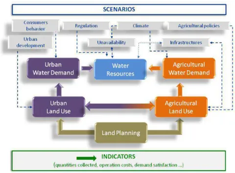
The model can be described as on the figure 1 within 6 interacting modules that constitute different domains of expertise or management.
The « Water Resources » module describes how each major water collection point in the territory is connected and constrained. Each water collection point is connected to a water body and managed by a Collector agent who is in charge of satisfying demands for specific uses linked to this point. This module is constrained by scenarios on regulation, water resource infrastructure building, and unavailability. The regulation level actually depends on external decisions. The infrastructures development and maintenance decision making is partially exogenous, for the big collective infrastructures (within the 20 years time frame, several options exist and have already been identified), and partially endogenous, for the individual infrastructures which development level is dependent on collective infrastructure service coverage, price and quality. The availability of the water resources is partially correlated to the climatic scenario and largely independent from the extraction level in the catchment, except for some collection points on the karstic aquifer. The actual connection dynamics is however unknown
G. Abrami et al. / Developing and integrating a simulation model of water resources…
and is a big uncertainity in the system (Pinault et al. 2004). Its monitoring and modeling is one of the big actions in the Integrated Management Contract and it will be steered in close relation with ours. Another uncertainity is on the actual uptakes and coverage of domestic and agricultural private boreholes.
The «Urban Water Demand» module calculates the domestic water demand for each municipality. It is constrained by the scenario on water consumer behaviors (mean water demand for each type of residential or tourism unity) and the residential and tourism structure coming from the « Urban Land Use » module. We represent the consumer’s behaviour as an external forcing even though relating endogenously water consumers’ demand to water prices was a demand expressed during the workshop. However studies tend to show it is difficult to find models that relate consumer demands to water prices (Rinaudo et al., 2012). Anyway in 2013 we will conduct an economic expertise on water costs and prices and will decide then if it would make sense to endogenize water consumer behaviours dynamics. The « Agricultural Water Demand » module calculates the irrigation water demand in each municipality. It is constrained by the climate scenario which sets the water demand level of the different crops, and the irrigated crops areas coming from the « Agricultural Land Use » module. We do not take in account farmers practices and consider that irrigation water demand is equal to the crops needs. This hypothesis was discussed and it was agreed that the model will be closed enough to reality if an irrigation water efficiency parameter is introduced.
The «Urban Land Use » module describes the residential and tourism land use dynamics of a municipality. It is constrained by the zoning, population and density objectives given by the land planning module. The hypothesis that urban development is never constrained by water availability and that the demographic pressure is sufficiently intense to fill all the urban development was acknowledged. We agreed on considering that municipalities always tend to respect zoning and density constraint but may under- or over- pass the population objective given the land planning. In a first version we will have the municipalities urbanising at a linear pace until 2030 so that their objectives are reached. This module is then very sensitive to the residential densities parameter which links population growth with space constraint. Following the recommendations of the working group, we will certainly remove the space occupation constraint in a first version of the prototype as in this stage it will induce an overparametrisation of the model. We will then test the model sensitivity to space constraint and decide whether it is worth making the effort of reintroducing it.
The « Agricultural Land Use » module describes the cropping pattern dynamics in the territory. It is constrained by the infrastructures scenario, the agricultural policies scenario, and by the land planning module. As it is said before, the infrastructures development is partially exogenous and partially endogenous: where aquifers are accessible, individual boreholes are created at a parameterized rate until some collective water access is created. The agricultural policies scenarios represent possible evolutions of CAP: the on-going grubbing-up premium induces a rate of wine crops turning into fallow without access to irrigation for instance. Finally the land planning module constrains potential urbanisation of agricultural land. This module holds quite a high uncertainty on the initial cropping pattern and access to irrigation in the territory and it will be very sensible on the parameterisation of the cropping transitions.
The « land planning» module sets the zoning, population and density objectives of each municipality according to the actual land management plan.
3.2 Model implementation
Our initial intention was to implement our model using the system dynamics modeling platform STELLA® to translate directly our causal maps. Some examples of system dynamics model of land and water management dynamics can be found in the literature (Payraudeau et al., 2004; Farolfi and Hassan, 2003) and there is even one of the Thau catchment describing the dynamics of the water and stovks of the system at the catchment scale (Celse et al, 2006). However we had a strong demand on representing the distribution of stocks and decision-making in
the catchment (the municipalities land use, the municipalities access to water, the municipalities zoning, the water collectors, the water resources…). We know it is possible to represent spatially distributed stocks (for instance Voinov et al. 1999) but this is tricky and as our causal maps did not include that much delays and feedbacks, we decided to shift to agent-based modeling which is more appropriate for our constraints of distributed decision-making (Bousquet and Le Page, 2004) and adaptivity of the model to context and stakeholders’ evolution .
We decided to use the platform NetLogo3 for developing a first prototype because it is very easy to use and appropriate for developing fast and dirty models. However for the tool that will be used with the stakeholders, we think the user interface system of Netlogo is not flexible enough when it comes to have non expert users having to interact with quite a lot of parameters and outputs. So we will shift for the implementation of the tool to another agent-based modeling platform, either Cormas4, which is well known and appropriate for natural resources management or GAMA5 which is new and appealing.
4 ELEMENTS OF DISCUSSION
This modelling exercise is happening on a territory that has already been heavily studied for many years. There is a large quantity of scarce data available. So one objective of our work is, rather than creating data, collecting, gathering and confronting existing data in a single artefacts. The main uncertainties in the system concern the karst aquifer dynamics and the boreholes actual and future covering. The main controversial figures are about domestic water scenarios : what figures should be taken for household consumption now and in the future, what are the actual figures of summer population and how will it evolve. A major concern of the water management institution is the economic evaluation of the different possible scenarios of water resources infrastructure, economic evaluation of prices and demand. For all these tricky parts of the modelling, choices will actually be political and will necessity careful monitoring and attention. In this type of modelling exercise where the objective is not to produce a predictive simulation tool but rather a grounded discussion support around the exploration of scenarios it is important to put efforts on analysing carefully the sensitivity of the model to the most tricky data and being careful on opening discussion on their selection. As a consequence the organisation of our workshops and the way we can stimulate interactions between the model and the stakeholders will be a very important part of our interdisciplinary effort.
We use grounded modelling to foster discussions within a stakeholders group. In this group several stakes are held that could be tackled by the model. However it is necessary to collectively agree on a focal stake to get further on with the modelling. Depending on the stake, some processes and data will be more important than some others, and the spatial and temporal framing of the inputs and outputs will be different. As stakes might evolve it is important that we can easily adapt and transform the model, being able for instance of aggregating or disaggregation certain parts. Even though what we have now is quite much a balance model that could be represented with spreadsheets, we think it is easier to keep flexibility and traceability using an agent-based modelling platform.
In Thau, there are tensions between contrasted vision of water resources development and management in the territory. Some stakeholders advocate for a centralised optimal technical management, when some other advocate for loose interconnexions and autonomy, and finally a few of them try to fight for a real integrated resources management. These tensions are strong but untold. We will
1111111111111111111111111111111111111111111111111 3 http://ccl.northwestern.edu/netlogo/ 4 http://cormas.cirad.fr/indexeng.htm 5http://code.google.com/p/gama-platform/ 1
G. Abrami et al. / Developing and integrating a simulation model of water resources…
have to manage and monitor carefully the companion modelling process so that we do not create a clash and are able to observe the modelling and simulation process as a revelation artefact in a system where what is told or untold, shown or unshown, has the greatest importance.
5 CONCLUSION
We described in this paper a companion modelling process about water resource quantity integrated management happening in south of France. Two years were spent in building a good partnership, defining a modelling question, drafting and refining a conceptual model, meeting stakeholders and collecting data and finally discussing a prototype and institutionalising the process. We put a lot of efforts in keeping the process as adaptable and open as possible. Because this is a grounded model, we will have to be very careful with the choices of the data and how these choices can be openly discussed during the workshops. This choice is actually political and will partially rely on the focal stake that will be chosen,
The water resource issue within the Thau catchment is not that much an issue of water sharing than an issue of integrated management of resources from different origins within a territory. The companion modeling process will be used to feed the reflexion on which resource is brought and used in the territory and at what cost. It will answer the concern written in the Integrated Management Contract of “building a global strategy which can relate the water resources potential that can be equitably shared with the actual and future needs”. The time spent in what is finally the initiation of a companion modelling process was the necessary time to get the necessary trust from the water management institution, align with the agenda and stakes of the existing discussion arenas, and adapt to their reconfigurations and dynamics. The institutionalising of the process within a contract is a guarantee that it will carry on even though political context or key people are changing. The counterpart is that SMBT role has evolved from partner to client of the process which might create tensions in the orientation of the process.
REFERENCES
Barone S, Gramaglia C, and Bouleau G. Bridges between lagoons: the political construction and uses of a "success story" in Thau and Berre (South France). In: 5th International Conference on Interpretative Policy Analysis, 23/06/2010 -
25/06/2010. Grenoble, FRA: 2010.
Barreteau O, Abrami G, Cernesson F, Ducrot R, Garin P, Le Goulven P, Maurel P, Richard-Ferroudji A, and Souchère V. Cities and their “water socio-footprint”: bilateral and dynamic interactions. In: Cities of the future. Boston: 2010.
Barreteau O, and others. Our Companion Modelling Approach. Journal of Artificial
Societies and Social Simulation [online] 6: \url{http://jasss.soc.surrey.ac.uk/6/2/1.html}, 2003a.
Barreteau O, Garin P, Dumontier A, Abrami G, and Cernesson F. Agent-based facilitation of water allocation: Case study in the Drome River Valley. Group
Decision and Negotiation 12: 441-461, 2003b.
Bousquet, F., Le Page, C. Multi-agent simulations and ecosystem management: A review. (2004) Ecological Modelling, 176 (3-4), pp. 313-332.
Bousquet F, Barreteau O, d'Aquino P, Etienne M, Boissau S, Aubert S, Le Page C, Babin D, and Castella J-C. Multi-agent systems and role games : collective learning processes for ecosystem management. In: Complexity and ecosystem
management, edited by Janssen MAEdward Elgar, 2002.
Bots P, Barreteau O, and Abrami G. Measuring solidarity in agent-based models of resource sharing situation. Advances in Complex Systems 11: 337-356, 2007. Celse J, Willinger M, and Valette F. Optimal exploitation of an renewable commune
resource using a software of simulation: an experimental study (DITTY (Development of an Information Technology Tool for the Management of European Southern Lagoons) report). 2006.
Chapelle A, Ménesguen A, Deslous-Paoli JM, Souchu P, Mazouni N, Vaquer A, and Millet B. Modelling nitrogen, primary production and oxygen in a Mediterranean lagoon. Impact of oysters farming and inputs from the watershed. Ecological Modelling 127: 161-181, 2000.
Farolfi S, Müller JP, and Bonté B. An iterative construction of multi-agent models to represent water supply and demand dynamics at the catchment level.
Environmental Modelling and Software 25: 1130-1148, 2010.
Farolfi, S., and R. M. Hassan. 2003. AWARE : A decision support tool towards decentralised water management in South Africa. in Water gouvernance and sustainable development, Sousse (Tunisia)
Guillo O, Protopopescu C, and Millet B. Water quality regulation in the Thau lagoon with optimal control of economic activities in closed-loop method. Méthode de
régulation de la qualité de l'eau du bassin de Thau par contrôle optimal stochastique, en temps réel, d'activités socio-économiques 28: 175-197, 2002.
Gurung TR, Bousquet F, and Trébuil G. Companion modelling, Conflict Resolution, and Institutional Building: Sharing Irrigation Water in the Lingmuteychu Watershed, Bhutan. Ecology and Society 11: URL : http://www.ecologyandsociety.org/vol11/iss12/art36/, 2006.
Maurel P, Craps M, Cernesson F, Raymond R, Valkering P, and Ferrand N. Concepts and methods for analysing the role of Information and Communication tools (IC-tools) in Social Learning processes for River Basin Management.
Environmental Modelling and Software 22: 630-639, 2007.
Metcalf SS, Wheeler E, BenDor TK, Lubinski KS, and Hannon BM. Sharing the floodplain: Mediated modeling for environmental management. Environmental
Modelling & Software 25: 1282-1290, 2010.
Payraudeau, S., Cernesson, F., Tournoud, M.G., Beven, K.J. Modelling nitrogen loads at the catchment scale under the influence of land use (2004) Physics
and Chemistry of the Earth, 29 (11-12 SPEC. ISS.), pp. 811-819.
Pinault JL, Doerfliger N, Ladouche B, and Bakalowicz M. Characterizing a coastal karst aquifer using an inverse modeling approach: The saline springs of Thau, southern France. Water Resources Research 40: W085011-W0850117, 2004. Plus M, Jeunesse IL, Bouraoui F, Zaldívar JM, Chapelle A, and Lazure P.
Modelling water discharges and nitrogen inputs into a Mediterranean lagoon: Impact on the primary production. Ecological Modelling 193: 69-89, 2006. Rinaudo, J.-D., Neverre, N., Montginoul, M. Simulating the Impact of Pricing
Policies on Residential Water Demand: A Southern France Case Study. (2012) Water Resources Management, pp. 1-12. Article in Press.
Sampson DA, Escobar V, Tschudi MK, Lant T, and Gober P. A provider-based water planning and management model – WaterSim 4.0 – For the Phoenix Metropolitan Area. Journal of Environmental Management 92: 2596-2610, 2011. Tournoud MG, Payraudeau S, Cernesson F, and Salles C. Origins and quantification of nitrogen inputs into a coastal lagoon: Application to the Thau lagoon (France). Ecological Modelling 193: 19-33, 2006.
Troussellier M, and Deslous-Paoli JM. Thau lagoon: A working site for the acquisition, integration and valorization of lagoon ecosystem knowledges. La
lagune de Thau: un site atelier pour l'acquisition, l'intégration et la valorisation des connaissances 27: 257-289, 2001.
Voinov A, and Bousquet F. Modelling with stakeholders. Environmental Modelling
& Software 25: 1268-1281, 2010.
Voinov, A., R. Costanza, L. Wainger, R. Boumans, F. Villa, T. Maxwell, and H. Voinov. 1999. Patuxent landscape model: Integrated ecological economic modeling of a watershed. Environmental Modelling and Software 14:473-491.