Publisher’s version / Version de l'éditeur:
Vous avez des questions? Nous pouvons vous aider. Pour communiquer directement avec un auteur, consultez la première page de la revue dans laquelle son article a été publié afin de trouver ses coordonnées. Si vous n’arrivez pas à les repérer, communiquez avec nous à PublicationsArchive-ArchivesPublications@nrc-cnrc.gc.ca.
Questions? Contact the NRC Publications Archive team at
PublicationsArchive-ArchivesPublications@nrc-cnrc.gc.ca. If you wish to email the authors directly, please see the first page of the publication for their contact information.
https://publications-cnrc.canada.ca/fra/droits
L’accès à ce site Web et l’utilisation de son contenu sont assujettis aux conditions présentées dans le site LISEZ CES CONDITIONS ATTENTIVEMENT AVANT D’UTILISER CE SITE WEB.
Environmental Informatics Conference, Environmental Informatics Archives
[Proceedings], 2, pp. 375-386, 2004-08-01
READ THESE TERMS AND CONDITIONS CAREFULLY BEFORE USING THIS WEBSITE.
https://nrc-publications.canada.ca/eng/copyright
NRC Publications Archive Record / Notice des Archives des publications du CNRC :
https://nrc-publications.canada.ca/eng/view/object/?id=26664de9-e318-43db-a945-11073ac8eec3 https://publications-cnrc.canada.ca/fra/voir/objet/?id=26664de9-e318-43db-a945-11073ac8eec3
NRC Publications Archive
Archives des publications du CNRC
This publication could be one of several versions: author’s original, accepted manuscript or the publisher’s version. / La version de cette publication peut être l’une des suivantes : la version prépublication de l’auteur, la version acceptée du manuscrit ou la version de l’éditeur.
Access and use of this website and the material on it are subject to the Terms and Conditions set forth at
Integration of municipal information systems for sustainable
management of infrastructure assets
Integration of municipal information systems for
sustainable management of infrastructure assets
Halfawy, M.R.; Vanier, D.J.; Hubble, D.
NRCC-47663
A version of this document is published in / Une version de ce document se trouve dans: Environmental Informatics Conference, Environmental Informatics Archives,
v. 2, 2004, pp. 375-386
Environmental Informatics Archives, Volume 2 (2004), 375-386 EIA04-038
ISEIS Publication #002
© 2004 ISEIS - International Society for Environmental Information Sciences
Integration of Municipal Information Systems for Sustainable Management of
Infrastructure Assets
Mahmoud R. Halfawy1*, Dana J. Vanier2, and David Hubble1
1
Centre for Sustainable Infrastructure Research, 2 Urban Infrastructure Programme, Institute for Research in Construction, National Research Council Canada,
Suite 301, 6 Research Drive, Regina, SK S4S 7J77
Abstract. The increasing requirements to maintain acceptable levels of performance in municipal infrastructure systems, combined with budgetary constraints, present significant challenges to municipalities. Sustainable management of municipal infrastructure assets requires the use of sound and reliable information systems that address a wide range of technical, economical and environmental issues. Throughout the past two decades, many infrastructure asset management software tools have been developed and are in use. However, most of these tools were developed for a single asset class lack an integrated and comprehensive view of the whole infrastructure asset management process. This lack of integration and interoperability creates inefficiencies and is a major impediment towards achieving sustainability objectives. Municipal information systems need to be integrated to enable better management of infrastructure assets. This paper presents a framework that uses integrated data models to provide all of the relevant information about different infrastructure assets. The framework integrates different tools, including life cycle cost and performance analyses, into one coherent GIS-based environment for the sustainable management of municipal infrastructure assets. To demonstrate how the framework can be implemented, a prototype sewer management system is presented.
Keywords: Municipal infrastructure, municipal information systems, sustainable asset management, GIS, integrated
asset management.
1. Introduction
Municipalities are facing unprecedented challenges in the management of their infrastructure assets due to the increasing number of aging infrastructure assets, the ever-increasing demand and sustainability requirements, increasing maintenance deficit, and declining or static maintenance budgets. Moreover, the increasing complexity and interdependencies of municipal assets have made the decision-making process increasingly knowledge-intensive, thereby requiring efficient management and integration of a wide range of accurate, detailed, and up-to-date databases. To address these challenges, municipalities need to improve the operational efficiency and effectiveness of managing infrastructure assets through adopting innovative techniques and methodologies, in particular by improving the management of their asset information and the capabilities of their decision support systems. Efficient management of information is a key requirement to support efficient operations and cost-effective decision-making throughout an asset’s life cycle, at all levels of asset management: operational, tactical, and strategic. This paper presents an approach that can potentially eliminate many of the inefficiencies in the asset management processes by enabling the integration and interoperability of Municipal Infrastructure Management Systems (MIMS).
Sustainable development and management of municipal infrastructure assets requires the use of reliable and sound information systems that address a wide range of technical, economical, environmental, and social issues. Municipalities typically use, develop and maintain a wide range of information systems to support the
multi-disciplinary decision making processes at various phases of the infrastructure life cycle: project brief, citizen consultation, planning, construction, operations, maintenance, rehabilitation, and decommissioning. Therefore, successful sustainability-based asset management strategies require addressing these diverse issues in an integrated manner.
Municipal asset management is a multi-disciplinary area that involves many activities including inventory itemization, inspection and data collection, condition assessment, performance evaluation, analysis and simulation, prediction of future performance, evaluating alternative technical and economic strategies, operations management, economic analysis, and planning and prioritization of maintenance and repair operations. A successful asset management approach aims to integrate and apply this diverse body of knowledge that spans these different areas with the main objective to maintain the condition of the assets at acceptable performance levels at minimum cost and within budget constraints.
During the past two decades, significant advances have been made in developing MIMS such as pavement management, bridge management, sanitary and storm sewer management, and water supply management. These tools have supported functions such as inventory and condition data management and reporting, maintenance management, and operations management, and have employed a wide range of algorithms for multi-objective optimization, probabilistic deterioration models for life cycle cost analysis, and techniques to accurately simulate and analyze system performance. The use of MIMS has significantly improved the operational efficiency, maintainability, and cost of municipal infrastructure assets. However, the majority of these were developed to function as stand-alone systems with limited or no capability to share and exchange information with other systems already in operation within the municipality. The proliferation of these tools has created an “islands of information” phenomenon in most of our municipalities. As a result, inefficiencies in data exchange and in the coordination of work processes have been commonplace. With the increasing number of software tools that address different aspects of the municipal infrastructure management processes, a major challenge that needs to be addressed is how to integrate these tools to support their seamless interoperation and the efficient sharing and exchange of data between different, possibly distributed and heterogeneous, systems.
Adopting an integrated approach to municipal asset management is necessary to address the wide spectrum of requirements of these processes (Lemer, 1998; Halfawy et al., 2002). Lack of integration and interoperability of MIMS has created several inefficiencies in the asset management processes as well as in the data flows between different stakeholders within municipalities and between municipalities and other organizations (e.g. provinces, utilities). Therefore, the integration of all municipal information systems is needed to overcome these inefficiencies and to support the sustainable development and management of the infrastructure assets.
This paper presents an integrated approach and a framework to support the implementation of a GIS-based MIMS. The proposed framework supports the integration of typical municipal infrastructure workflow processes, whereby a central data model of the infrastructure assets is used to integrate various aspects of the infrastructure management processes. The framework supports sharing and management of the infrastructure asset information and enables the integration and interoperation with legacy software tools.
2. Current State of Practice in Municipal Infrastructure Management Systems (MIMS)
A municipal infrastructure management system is used to store and manage all relevant information concerning an infrastructure asset and to support the operational, tactical and strategic decision-making processes in areas related to asset operation, maintenance, repair, rehabilitation, and replacement. MIMS are typically implemented on top of Relational Database Management Systems (RDBMS), with the main purpose to support storing, organizing, querying, managing, analyzing, and reporting asset data. A number of competing or complementary RDBMS systems can exist in larger municipalities. Add-on modules that interface with the database are also used to perform specific functions such as data collection and analysis, condition assessment, performance prediction, status reporting, maintenance planning and prioritization, and life cycle cost analysis. These systems may also provide some level of GIS functionality or support interfacing with commercial GIS software.
MIMS can be classified into two broad categories: general-purpose software and asset-specific software. General-purpose systems typically offer generic functionality that can be customized and adapted for specific data and work processes. Asset-specific software solutions primarily focus on supporting management processes for a specific class of municipal asset (e.g. buildings, sewers, roads, bridges, etc.). The main functionality provided by general-purpose systems is the management of inventory and condition data. Unlike general-general-purpose systems, the asset-specific solutions implement asset-specific data and process management procedures that are required to support the management of the particular class of infrastructure.
Environmental Informatics Archives, Volume 2 (2004), 375-386
377
Despite the availability of several commercial software systems, many municipalities find the functionality offered by these systems either too limited or too extensive. To overcome the limitations of generic solutions, many municipalities have developed their own in-house customized asset management systems. An in-house asset management system is typically developed by customizing general-purpose software (e.g. RDBMS, CAD, or GIS platforms).
In a typical MIMS, the database records of each component of an asset are referenced by the component’s unique identification number (IDs). The lack of a graphical representation of the asset would require end-users to identify and access the data through the unique component IDs. In addition, without graphical representation, the spatial characteristics of the asset components are communicated to the end users in non-intuitive textual formats. Experience shows that this form of data access is an impediment to efficient data retrieval and analysis. To overcome this limitation, many MIMS used CAD software to graphically represent the asset’s spatial data, define and attach the non-graphic (attribute) data to the graphical objects, and use the RDBMS to manage the asset’s data. However, a major drawback of these CAD-based systems is their limited data management functionality and the difficulty of updating and maintaining the linkages between the data stored in the database and the drawing files. Also, CAD models are typically represented using primitive geometric objects (e.g. lines, curves, points, and polygons). These CAD models often lack the semantics needed to define the assets or their inter-relationships, which would limit the analysis capabilities of these models.
Unlike CAD, GIS has traditionally emphasized the use of semantic rich object models that are linked to an RDBMS to store and manage the attribute data associated with the spatial objects (or features) and topologies defined in maps and drawings. A GIS-based MIMS typically stores the graphical data (e.g. maps, themes, features) using a proprietary file format while using the RDBMS to store and manage the attribute (or non-graphical) data associated with the assets. The attribute data provide information about the assets, such as the type of entity, its properties, condition, maintenance data, etc. GIS data identifies objects as “features” which typically have more semantics than traditional CAD objects. In addition, spatial relationships among different features (e.g. topologies) are explicitly defined. The data management functionality and the capability for linking attribute data and graphical objects are readily available in GIS software. The GIS maintains the link between the spatial features and the attribute database records using a unique identification for each feature. The GIS will also allow for the creation, storage, maintenance, retrieval, query, analysis, and display of various features and their associated information. GIS software usually supports importing files, such as design and inventory data, from other GIS and CAD software formats.
Many CAD systems have recently introduced GIS-like functions for data management and the modeling of semantic-rich data models. However, the ease of linking graphic and non-graphic data, as well as the built-in spatial analysis capabilities of GIS remain to be the key features that are unparalleled by most CAD systems. A GIS platform can better support a fully integrated MIMS by its spatial data management, visualization, query, and analysis capabilities.
Due to the recent availability of affordable and easy to use GIS hardware and software, and due to a realization of the useful role that GIS can play within municipalities, there has been an increasing trend to use GIS and geospatial technologies for municipal asset management. A survey of “Current GIS Practices in Municipal Infrastructure Management” (Vanier, 2003) has indicated that many municipalities across Canada have already started implementing and using GIS technology to support a wide range of administrative processes, but few have implemented sophisticated solutions for infrastructure management processes. Moreover, many existing applications are now providing interfaces with GIS software and implementing several spatial data management and analysis functions. The next generation of these applications will clearly be GIS-based and will tend to exploit the capabilities of spatial data technologies to support various aspects of sustainable municipal asset management. GIS technology is becoming an integral component in almost all modern municipal information systems.
A GIS-based MIMS would typically consist of a spatially based asset inventory, including information about the physical and structural characteristics such as geometry, material, classification, as-built materials and thickness, surface types, and maintenance histories, among others. Users could quickly visualize the physical and spatial characteristics of the assets, view the inter-relationships and inter-dependencies of the spatial data, and navigate through the information by accessing various data cross-referenced from the spatial representation of the physical components. A wide selection of GIS add-ons would further support data management, analysis, and visualization and provide better decision-support capabilities.
However, and despite its apparent potential, GIS technology is still largely underutilized in the public works domain of most municipalities, and its use can be further extended. In many cases, municipal GIS systems are primarily used to support the storage and retrieval of maps. The value of a GIS system in supporting data management, query, and analysis, remains largely unused or underutilized. There is an obvious need to leverage the
role and functionality of GIS to enhance the municipal infrastructure management processes and to provide better decision-support and analysis capabilities. A key challenge to achieve this objective is to enable the integration and interoperability of MIMS through standardized representation of both municipal spatial and non-spatial data.
A municipal infrastructure management system would have many potential uses to support the workflow and asset management processes. Examples of these uses include:
• Enable efficient collection, storage, query, retrieval, management, analysis, and reporting of asset information, which would support making informed decisions based on accurate, reliable and up-to-date information.
• Support more efficient and cost-effective decision-making processes by implementing systematic methods and algorithms to analyze condition data, prioritize maintenance operations, and to optimize the allocation of the limited maintenance budget according to the required performance levels and the risk associated with deteriorating assets components.
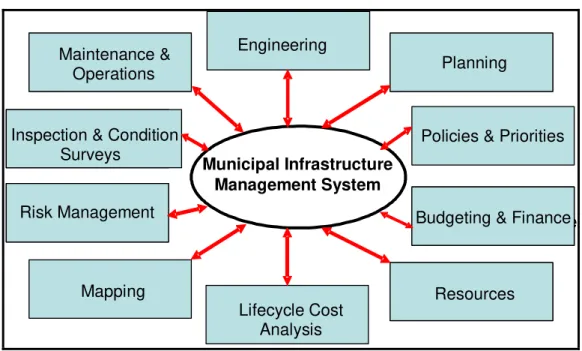
• Integrate and manage various aspects of the municipal assets life cycle by integrating different workflow processes and their associated datasets. This integration would aid in supporting and improving the efficiency of the decision-making processes (Figure 1).
• Enable the sharing of data across the municipality and provision of selected information to other agencies (e.g. utility companies).
• Increase operational efficiency by aiding in the planning, execution, budgeting, and coordination of maintenance operations, and tracking and managing the information related to projects, work orders, inspections, as-builts, etc.
• Assist municipalities and other government agencies in coordinating and optimizing the allocation and distribution of maintenance budgets according to the priority and risk associated with deteriorating components of the assets
Municipal Infrastructure Management System
Engineering
Policies & Priorities Maintenance &
Operations Maintenance &
Operations
Inspection & Condition Surveys
Inspection & Condition Surveys Risk Management Risk Management Mapping Lifecycle Cost Analysis
Budgeting & Finance Budgeting & Finance
Planning Planning
Resources Resources
Figure 1 Municipal Infrastructure Management Systems as Integrators of Data and Workflow Processes
3. A Model-Based Approach to the Integration of Municipal Infrastructure Management Systems
The lack of interoperability and inefficient data exchange between legacy software tools has been a major impediment to communicate infrastructure information in a timely, efficient fashion. The proposed framework addresses this challenge by defining an information modeling architecture that employs a model-based approach to
Environmental Informatics Archives, Volume 2 (2004), 375-386
379
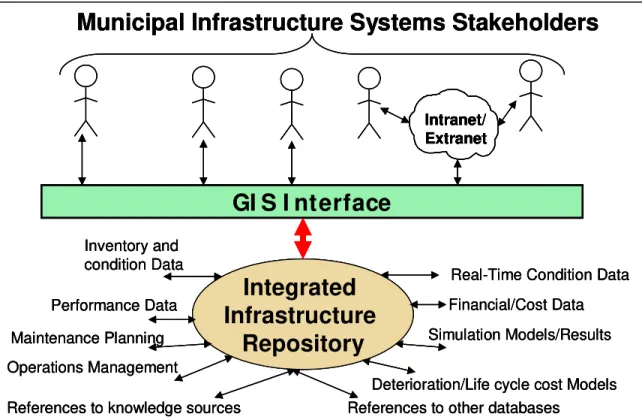
integrate information across various disciplines and to map data models from one tool’s perspective to another. This approach involves the use of a central data model to represent the physical structure of the infrastructure and link (or cross-reference) various aspects of infrastructure information, such as inspection data, performance data, maintenance data, and cost data, with that data model. The resulting “integrated model” represents a comprehensive view of the infrastructure system and is the glue that binds together various perspectives of the assets information. It also supports efficient gathering, organizing, management, and distribution of information. Figure 2 explains the role of the integrated data model to support information sharing and exchange.
GI S I nterface
Intranet/ Extranet
Municipal Infrastructure Systems Stakeholders
Integrated
Infrastructure
Repository
Inventory and condition Data Performance Data Maintenance Planning Financial/Cost DataDeterioration/Life cycle cost Models Simulation Models/Results
Real-Time Condition Data
References to other databases References to knowledge sources
Operations Management
GI S I nterface
GI S I nterface
Intranet/ Extranet
Municipal Infrastructure Systems Stakeholders
Intranet/ Extranet Intranet/ Extranet
Municipal Infrastructure Systems Stakeholders
Integrated
Infrastructure
Repository
Inventory and condition Data Performance Data Maintenance Planning Financial/Cost DataDeterioration/Life cycle cost Models Simulation Models/Results
Real-Time Condition Data
References to other databases References to knowledge sources
Operations Management
Integrated
Infrastructure
Repository
Inventory and condition Data Performance Data Maintenance Planning Financial/Cost DataDeterioration/Life cycle cost Models Simulation Models/Results
Real-Time Condition Data
References to other databases References to knowledge sources
Operations Management
Figure 2 Applying a Model-Based Approach to Municipal Asset Management (Halfawy et al, 2002) The model-based approach provides many benefits to the various infrastructure management activities. First, in addition to the inventory and condition data, the model enables the representation of a wide range of information about other infrastructure aspects (e.g. performance characteristics, maintenance planning, operations, cost, etc.) as well as other forms of information such as inspection reports, maintenance records, drawing files, etc. The integrated data model provides a single point of access to all infrastructure relevant information and knowledge. Second, the model can significantly improve the communication among stakeholders by making various aspects of assets information accessible from one centralized data repository. Stakeholders from different disciplines could use the integrated data model to access information in their respective domains. Third, the model enables tool interoperability and the efficient sharing and exchange of information. By sharing the data model, the need to map and translate the data from one tool’s format to another is minimized or eliminated altogether. Fourth, the integrated model helps to streamline the workflow processes and to create direct links between these processes with their associated datasets. Lastly, the integrated model facilitates integrating different inventory systems, such as sewers, roads, bridges, and facilities into a single database that integrates information across various municipal assets.
A primary goal of the integrated data model is to facilitate the development of integrated software systems that can support managing multiple municipal assets. In a typical municipality, different systems are used to manage different assets, and each system typically manages a separate database about that asset information. An integrated system stores asset data in a centralized repository that can maintain cross-references and relationships between different assets in a consistent manner. Such integrated systems can support and the investigation of the interactions and dependencies between different assets that may be co-located, overlapping, or in close proximity. These
integrated systems can also eliminate duplication and inconsistencies in the collecting, processing, and storing of asset data
The benefits of using an integrated infrastructure data model could be further leveraged in two main ways. First, accessing the integrated data model through a GIS interface will further enhance the ability to explore, navigate, access, and query infrastructure data. Assisted by the GIS functionality, this integration can potentially improve the efficiencies, cost-effectiveness, and coordination of maintenance plans and work processes, and lead to minimizing rework and waste of resources. Various infrastructure management activities, such as maintenance planning and operations management, could be supported and enhanced using the GIS spatial representation of the infrastructure. Users could visualize the physical and spatial characteristics of the infrastructure, and navigate through the information by accessing various aspect data cross-referenced from the physical components. Second, standardizing the data model would further enhance the role such models could play. Developing and adopting an industry wide standard data model will enable better integration of the infrastructure management activities and interoperability between various software applications (Halfawy, 2004). Using a standard data model, software developers supporting this standard would guarantee the interoperability of their software tools. Without such standards, integrating different tools into an integrated system would require implementing adapters to map the ad-hoc data models that different tools use to and from the integrated data model. A standard model would facilitate efficient data sharing and exchange, and improve the consistency and quality of infrastructure information.
4. A Framework for Developing Integrated GIS-Based Municipal Infrastructure Management Systems Integrated GIS-based MIMS are complex software solutions that require special design to satisfy their wide range of requirements and objectives. Defining a robust and flexible architecture can facilitate the development of successful and practical MIMS and asset management software tools. Also, a common architecture can potentially improve the consistency of applications in the domain, and enable better interoperability and reusability of different components and applications. This section briefly presents a framework for developing integrated GIS-based MIMS. The framework aims to integrate different tools and technologies into one coherent environment to enable municipalities to address various aspects of asset management from an integrative perspective. The framework is intended to serve as a reference architecture to support the implementation of integrated and distributed GIS-based municipal information systems. More details about the framework can be found in Halfawy et al (2002).
The framework has a modular component-based architecture to accommodate future modifications, possible extensions, and technology improvements. The framework supports the integration of asset management processes by adopting the model-based approach described above whereby a central data model is used to integrate different aspects and views of the assets. Access to assets’ data repositories, knowledge sources, and software applications is enabled through a unified and integrated GIS interface. The framework separates the responsibilities between the function-specific software applications set and generic services components. Function-specific software applications provide users with the functionality to perform specific tasks, while the components provide the functionality to integrate and manage different processes.
Given the complexity and scalability requirements of MIMS, a multi-tier component-based architecture seems particularly suitable. The framework architecture has been created by breaking down the required functionality into a set of specific services and then mapping these services into a set of components. Components are coarse-grained, reusable, software subsystems that perform a specific set of functions. The component-based architecture helps to maintain framework flexibility and extensibility as upgrading or extending any of the components will have little impact on the rest of the framework. An important feature of the component-based architecture is that different parts of the framework can be running in a distributed environment over the Internet. The tiered architecture, on the other hand, helps to separate the responsibility and functionality of the GIS interface, the function-specific applications, and the common domain-specific components.
Figure 3 shows a conceptual view of the framework’s main components. The proposed four-tier architecture includes: the GIS interface tier, applications tier, common asset management services tier, and infrastructure data repository tier. The GIS tier implements the spatial interface to the integrated spatial data model and allows users to access the framework functionality through a unified intuitive graphical interface. The tools at the applications tier support specific tasks, while the common services components at the middle tier implement a set of generic domain-specific services (e.g. information management, operations management). The following sections briefly describe each tier.
Environmental Informatics Archives, Volume 2 (2004), 375-386
381
Mapping Tools
Municipal Infrastructure Data Repository Condition Assessment Modeling/ Simulation
GI S I nterface Tier
MR&R PlanningApplications Tier
Infrastructure Data Tier
Common Infrastructure Management Services Tier
Real-time Data Acquisition Cost Estimating Performance Prediction Active Control System Risk Analysis Work Order Management Report Generation Optimization Tool Data Management Package Document Management Package Modeling & Simulation Package Maintenance Planning Package Workflow Management Package
Adaptor Adaptor Adaptor Adaptor Adaptor Adaptor
Mapping Tools
Municipal Infrastructure Data Repository Condition Assessment Modeling/ Simulation
GI S I nterface Tier
MR&R PlanningApplications Tier
Infrastructure Data Tier
Common Infrastructure Management Services Tier
Real-time Data Acquisition Cost Estimating Performance Prediction Active Control System Risk Analysis Work Order Management Report Generation Optimization Tool Data Management Package Data Management Package Document Management Package Document Management Package Modeling & Simulation Package Modeling & Simulation Package Maintenance Planning Package Maintenance Planning Package Workflow Management Package Workflow Management Package
Adaptor Adaptor Adaptor Adaptor Adaptor Adaptor
Adaptor Adaptor Adaptor Adaptor Adaptor Adaptor
Figure 3 The Component-Based Framework for Integrated Municipal infrastructure management systems (Halfawy et al, 2002)
The GIS Interface Tier
This tier implements the GIS interface to the integrated spatial data model that is constructed and maintained by the framework tools and components. The GIS interface tier serves as a graphical front-end to the assets data repository that provides the ability to access data locally, or over an Intranet or Internet. Other function-specific applications employ the GIS functionality to enable users to efficiently explore and analyze spatial aspects of the municipal infrastructure systems. Users could query the municipal infrastructure system for its current performance and physical parameters, and visualize the spatial characteristics of the assets. Assets are represented as map features with certain spatial relationships, and attributes are assigned to these map features and used to associate the features with their corresponding data tables and records in the data repository. The GIS interface provides the means to navigate through and query the database and to carry out “what if” analysis. Users can simply point to the map features representing assets physical components and query the system or retrieve data related to the selected features.
The Applications Tier
This tier integrates a set of function-specific applications so that they can effectively and seamlessly interoperate and share data from the integrated asset data model. Mapping the integrated model to and from ad-hoc information models (commonplace in most organization) supported by individual tools is achieved by using adapters as shown in Figure 3. However, the need to implement adapters will continue until industry-wide standard data models are developed and supported by different applications. The different applications can access the framework through the components’ interfaces, and thus the framework makes no assumptions on the implementation details of individual tools. Making the framework tool-independent provides the flexibility to upgrade or replace any tool without impacting other components.
The Common Infrastructure Management Services Tier This tier includes a set of generic components such as: The Data Management Package
This component offers data management services such as maintaining the data repository, mapping between the integrated data model and application-specific data models, concurrency control, and transaction management. This component is developed on top of the database management system. The data management components are used by different applications to interface with the asset data repository. An important functionality of these components is to support data collection and organization. The component provides functionality to support different data collection technologies (e.g. visual inspection, NDE, remote monitoring using network of sensors), and to automatically update the data repository to reflect up-to-date status of the assets.
The Document Management Component
A large portion of infrastructure information, such as drawings, condition data, and maintenance records, , is represented and exchanged as documents that need to be managed. Document management uses a set of document attributes, or metadata, to classify, organize, search, and retrieve documents. The document management package defines metadata attributes that effectively describe a document, and establish a bi-directional link between these attributes and the objects in the data model, and thus enables context-based access to documents directly from the infrastructure object model.
The Modeling and Simulation Package
This component provides functionality to support life cycle modeling of the assets. Infrastructure management systems typically use several models to predict future performance, to plan maintenance operations, to evaluate performance and cost of alternative strategies, and to optimize maintenance funds allocation. Modeling various aspects of an infrastructure asset is generally a costly and time-consuming task. However, techniques to generalize a class of models for particular types of infrastructure systems in the form of “a library of model templates” can be customized for specific infrastructure systems. This functionality significantly facilitates the process of model construction and the linking of model data with the data repository.
Four main classes of models have been identified: simulation models, deterioration models, optimization models, and cost models. Simulation models simulate the system performance. Deterioration models estimate future infrastructure condition. Optimization models determine the most optimum allocation of resources in order to sustain acceptable levels of performance. Cost models estimate items such as the present value of user cost, organization cost, and maintenance cost. The modeling and simulation package facilitates the construction of these models and their integration with the data repository.
The Maintenance Planning Package
This component implements methods to enable the successful planning, scheduling, and tracking of maintenance operations and estimating maintenance costs. The component uses different modeling approaches to determine the best maintenance options based on life cycle cost analysis, optimal prioritization of maintenance operations, estimation of budget requirements for future maintenance, and comparison of alternative cost-effective maintenance plans.
The Workflow Management Component
This component provides services to coordinate, monitor, and manage maintenance operations. The component implements a workflow model, supplied by end-users, to represent and guide the maintenance operations and to define the inter-dependencies of various operations. The workflow model shows the data flow across various maintenance operations. The workflow model can also assist in automating routine tasks such as scheduling periodic inspections and preventative maintenance activities. Another function of this component is to manage work orders and service requests. Work orders can be automatically generated based on service requests, complaints, and condition data. The component can also log, assign, track, and control work orders.
The Infrastructure Data Tier
The data repository provides a single point of access to all assets data, which can significantly improve the collection, organization, consistency, and availability of information. The repository is typically implemented using a Database Management System (DBMS) that can potentially support distributed data sources and implement concurrency control mechanisms. The repository schema is defined based on the integrated spatial data model of the assets. The repository contains data about the inventory, condition, and performance characteristics. Inventory data includes physical attributes that define design parameters of the assets’ structural components. Condition attributes define the current status of these components and may include data from visual inspection, NDE tests, or from
Environmental Informatics Archives, Volume 2 (2004), 375-386
383
remote sensors. Performance attributes define the current performance metrics (or indices) of the structural components.
The repository also supports the representation, organization, sharing, and reuse of asset management knowledge. This knowledge may include structure-specific knowledge related to the assets’ physical characteristics, inspection requirements and procedures, life cycle management, assessment, maintenance and rehabilitation knowledge, operations management knowledge, and procedures or best practices for field tests, performance evaluation, and maintenance tasks.
5. Example Implementation of an Integrated GIS-Based Sewers Management System
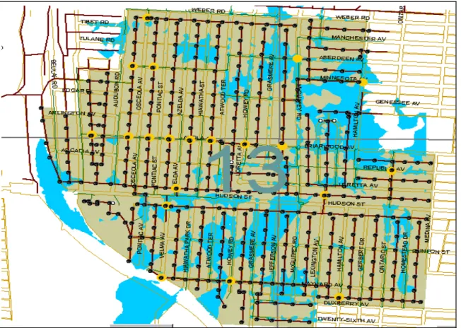
A prototype integrated sewers management system was implemented to support the maintenance management of a sewers network in an area of approximately 27 square miles. A more detailed description of the system can be found in Halfawy et al. (2000). The prototype implemented several of the proposed framework components and also integrated a number of software applications. An integrated data model of the sewer system was developed to represent a comprehensive view of the sewer network’s structural, spatial, condition, and performance characteristics, and to link a wide range of “unstructured” information to that data model. Unstructured information included inspection reports, CCTV inspection video clips, manhole and sewer pictures, textual description, sketches of various parts of the network, and CAD drawings that show details of manholes (corbel/frame cross section and plan view).
The sewer system data repository was implemented using two relational database management systems. The first database was implemented using Hansen’s Infrastructure Management System (IMS) software, which employs an Oracle RDBMS. This database included the sewer system inventory data where all the details of the sewer system physical characteristics are stored. The sewer system inventory data was mainly extracted from existing maps and drawings. Sewer attributes such as pipe length, diameter, slope, invert depths, offsets, material, and year built, were extracted from the record plan drawings. The second database was implemented using Microsoft Access to store the sewer system condition data. Relational schemas were developed to model the sewer network inventory and condition data. Information about the sewer system condition was collected as a result of field-testing and inspection in an extensive Sewer System Evaluation Survey (SSES). The survey included the inspection of 1184 manholes; smoke testing of 267,162 linear feet of sanitary sewer; 38,912 feet of Closed Circuit Television (CCTV); 32 Dyed water tests; and the use of 7 flow meters; 10 groundwater piezometers; and 4 rain gauges. The survey results were also used to verify the accuracy of the inventory data collected from the record plans.
The data management component enabled users to access the infrastructure data repository using two interfaces: Hansen’s IMS interface to the inventory database and an Microsoft Access interface to the condition database. The component implemented a set of predefined queries and reports to facilitate the retrieval of critical information from the repository. The predefined queries retrieve information such as: detailed data on all manholes and sewers; collection system summaries; manhole cover inflow; repair recommendations; condition of various components of the system (e.g. leaking mains, leaking manholes, broken/cracked pipes); condition of various manholes and sewer lines; smoke test results in various locations; images associated with manholes, lines, and video clips of CCTV inspection. Links to digital photos and video clips were maintained in the condition database. The framework’s set of software applications and components were also able to access the repository using the standard Open DataBase Connectivity (ODBC) protocol. The relational architecture of the database enabled the repository to be easily accessed, queried, and manipulated by other framework components.
The GIS interface was implemented using ArcView and Avenue programming language. The GIS interface was used to present the sewer network data in its spatial context and to allow users to interactively and graphically access, query, and manipulate the data stored in the repository by simply pointing to map features. The sewer system components, represented as map features, are linked to relevant information in the repository. For example, a manhole is linked to its inspection reports, images of the manhole, CAD drawings, results of any field tests performed at the manhole or at a location close to the manhole, records in the inventory database, etc. The GIS interface was also facilitated the presentation and analysis of the spatial relationships among the sewer network components. Examples of these relationships include adjacency (i.e. manholes in a specific area), connectivity (e.g. sewer lines connected to specific manholes), and containment relationships (e.g. manholes or sewer lines contained in a specific area). The GIS representation of the sewer system characteristics, such as Infiltration/Inflow (I/I) sources, enabled users to explore, query, visualize, and analyze various aspects of the system and to make decisions about maintenance and improvement work.
Figure 4 Integration of Spatial Representation, Simulation Models, and Data Management (Halfawy et al, 2000)
The basic approach to create the sewer network maps was to scan the record plans, geo-register the scanned maps with the base map, and then use drawing tools to draw various features such as sewer lines (line features), manholes (point features), and land parcels and buildings (polygon features), and specifying spatial relationships among these features. Several map themes (or layers) were defined; Examples include: base maps, manholes, sewer lines, sanitary sewer overflow (SSO), Atlas sheet boundaries, right of way, edge of pavement, centerlines, parcel lines, buildings, topography, locations with positive smoke testing results, CCTV inspected lines, and sub-sewer shed boundaries. Themes were represented using three main formats: AutoCAD DWG files, ArcView shape files, and ArcInfo coverages. Features attributes were assigned for subsequent joining with the corresponding records in the data repository. For example, using the ID of a sewer line feature, sewer attributes such as pipe length, diameter, slope, invert depths, offsets, material, and year built, could be extracted from the repository.
One of the applications that were integrated into the system is the EPA's Storm Water Management Model (SWMM) software. SWMM was used to simulate and analyze the sewer system, to predict and assess the consequences of various events, and to help evaluate different maintenance scenarios. Integrating this legacy application required implementing an adapter to map the integrated data model to and from SWMM data model. Also, SWMM output files are in a text-based form that includes a tabular description of flow within the modeled system, including information about maximum flow levels and pipe capacity. Preparing SWMM data files and interpreting the output files are known to be very time consuming, which would limit the users’ ability to conduct simulation and performance analysis studies. To overcome this limitation, the SWMM adapter was also implemented to serve as both a pre-processor and post-processor.
Construction of SWMM models was partially automated by extracting the sewer system data from the shared data repository. Other model data, such as land use and demographic data, watersheds physical and hydraulic characteristics were added manually by end users to the model. The adapter also enabled users to visualize and get insight into the enormous amount of data generated from the simulation runs by displaying and manipulating the model data and results of the simulation runs in a graphical form on the GIS interface. For example, with a simple query, the sewers or structures that were flooded could be highlighted (Figure 4). SWMM models were calibrated based on measured values of rainfall, sanitary and storm flow meters, depth meters in the designed cross connections,
Environmental Informatics Archives, Volume 2 (2004), 375-386
385
and groundwater wells. The models were used to simulate the sewer network performance under various conditions. The integration of the simulation models with the data repository and the GIS interface in the framework has significantly improved the ability to perform extensive evaluations of the sewer network performance using several “What if?” scenarios (e.g. sanitary sewer overflows to the storm water sewers, impact of sewer failure, etc.). Without such integration, these evaluations would be prohibitively costly and time consuming.
6. Conclusion and Future Directions
Sustainable management of municipal infrastructure assets is becoming more focused on the integration of all the multi-disciplinary aspects of the process. The development and deployment of integrated municipal infrastructure management systems is becoming more of a necessity in the face of the challenges that municipalities currently face. Integrated MIMS can significantly improve the availability and consistency of the relevant data across different software systems and platforms, can serve to integrate data across various disciplines, and can facilitate the flow and exchange of information between various parties involved. This would eliminate inefficiencies in information access and exchange, resulting in more cost-effective operations.
The framework described above can potentially provide municipalities with a tool to leverage the use of their existing systems and technologies, and thus help municipalities to protect their existing investment in information technology tools, while encapsulating these tools into integrated and more efficient systems. The framework also identifies the requirements and the major issues involved in developing these systems. Specifically, the framework supports integrated infrastructure asset management by: (1) supporting the modeling and management of infrastructure data and enabling shared access to that data; (2) supporting the interoperation of software tools and defining methods to integrate legacy software tools into the framework; (3) providing a set of services to support infrastructure life cycle modeling, maintenance planning, and operations management; and (4) integrating the information models of various disciplines through adopting an integrated model-based representation of the infrastructure assets. In addition to the need to address more thoroughly the many issues highlighted by the framework, we can identify some important directions for future research.
Leveraging the use of geospatial technologies, in general, and of GIS and asset management systems, in particular, to improve the efficiency and effectiveness of asset management work processes is a critical requirement of sustainable management of municipal assets. Lack of interoperability and inefficient data exchange between MIMS has been a major impediment to the efficient access and communication of asset information. Efficient data sharing and software interoperability play a crucial role in supporting efficient data access and retrieval, which in turn is important to support efficient operations and cost-effective decision-making processes at all levels of municipal government.
Generally, the workflow processes in most municipalities are not engineered to support integration. An integrated municipal infrastructure management system can help integrate the data flow with the associated workflow processes, improving efficiency and coordination. Integrated information systems can help municipalities to re-engineer their work processes to tackle communication and coordination problems, and eliminate inefficiencies.
Municipalities need to devise information management and handover strategies to ensure the reusability of design and construction information delivered at the end of construction or maintenance projects, and to integrate this information into the database to reflect the updated status of assets. Information loss during hand-over processes is commonplace in the industry, and many problems may arise as a result. An information hand-over strategy would specify the kind and format of the as-built information to be handed over and stored in the data repository for future use.
Of particular interest to our research is the integration of smart infrastructure concepts into the framework. Smart infrastructure systems would involve the use of advanced remote sensing technologies to support real-time continuous and remote monitoring of the infrastructure system. Accessing performance and condition data in real-time and enabling continuous monitoring will be invaluable in enhancing the capability to devise proactive maintenance plans.
Another important issue is the development of integrated model-based representation of various types of municipal infrastructure assets. An effort to develop a standard and integrated data model for sewer systems is ongoing as part of the MIIP project (Vanier, 2004). Many similar efforts and initiatives that aim to standardize asset data models are underway. Finally, some industry-oriented research is also needed to assess the affect of implementing integrated MIMS and how these systems would improve the overall operation of municipalities.
Acknowledgment
This work is supported by the Center for Sustainable Infrastructure Research (CSIR) at the Institute of Research in Construction (IRC), National Research Council Canada (NRCC).
References
Halfawy, M.R., D. Pyzoha, R. Young, M. Abdel-Latif, R. Miller, L. Windham and R. Wiegand (2000). GIS-based sanitary sewer evaluation survey. 20th Annual ESRI International User Conference, Jun., San Diego, CA, 2000, gis.esri.com/library/userconf/proc00/professional/papers/PAP158/p158.htm
Halfawy, M.R., David Pyzoha, and Taymour El-Hosseiny, (2002). An Integrated Framework for GIS-Based Civil Infrastructure Management Systems, Proceedings of the CSCE 2002 Conference of the Canadian Society for Civil Engineers, Montreal, Canada, June 5-8, 2002.
Halfawy, M.R., (2004). The Interoperability of Geographic Information Systems for Municipal Asset Management Applications, Municipal Infrastructure Investment Planning (MIIP) Project Report, Inst. for Research in Construction, National Research Council Canada, Ottawa, April 2004.
Lemer, A.C., (1998). Progress Toward Integrated Infrastructure-Assets-Management Systems: GIS and Beyond, APWA International Public Works Congress, NRCC/CPWA Seminar Series: Innovations in Urban Infrastructure, 1998.
Vanier, D. J., (2004). Towards Geographic Information Systems (GIS) as an Integrated Decision Support Tool for Municipal Infrastructure Asset Management, CIB 2004, Toronto.
Vanier, D. J., (2000). Municipal Infrastructure Investment Planning (MIIP) Project: Statement of Work, Inst. for Research in Construction, National Research Council Canada, Ottawa, January, 1–17, 2000.