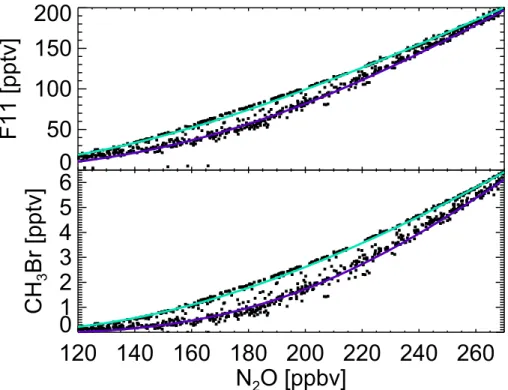
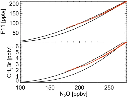
Strategies for measuring canonical tracer relationships in the stratosphere
Texte intégral
Figure


Documents relatifs
Generalizing the work of Lubin in the one-dimensional case, conditions are found f existence of canonical subgroups of finite height commutative formal groups of arbitrary
cone over a quadric Q C p4 containing É. Thus the quadric.. But we know that Fi n F2 contains the five points of intersection of V with the quintic. surface S..
In this section, we recall the fundamental challenge for Nos´ e dynamics, that of obtaining ergodic sampling of the extended phase space, and then describe a method by which the
On the other hand, the second class constraints of Plebanski formulation, supposed to be the starting point of the SF approach, lead to Dirac brackets and a modified symplectic
In Section 4, we assume that the Cartan matrix of g is symmetric and recall Lusztig’s construction of the canonical and semicanonical bases; we relate ≤ pol to the degeneracy
Write a degree 2 polynomial with integer coefficients having a root at the real number whose continued fraction expansion is. [0; a,
A geodesic triangle on Riemannian manifold is a triangle all of whose ver- tices are geodesics.. On a sphere, for example, the curvature is always 1 which means that the sum of
Bounded cohomology, classifying spaces, flat bundles, Lie groups, subgroup distortion, stable commutator length, word metrics.. The authors are grateful to the ETH Z¨ urich, the MSRI
