HAL Id: hal-00299131
https://hal.archives-ouvertes.fr/hal-00299131
Submitted on 25 Jan 2005
HAL is a multi-disciplinary open access
archive for the deposit and dissemination of
sci-entific research documents, whether they are
pub-lished or not. The documents may come from
teaching and research institutions in France or
abroad, or from public or private research centers.
L’archive ouverte pluridisciplinaire HAL, est
destinée au dépôt et à la diffusion de documents
scientifiques de niveau recherche, publiés ou non,
émanant des établissements d’enseignement et de
recherche français ou étrangers, des laboratoires
publics ou privés.
Geophysical and stratigraphical research into deep
groundwater and intruding seawater in the
mediterranean area (the Salento Peninsula, Italy)
S. Margiotta, S. Negri
To cite this version:
S. Margiotta, S. Negri. Geophysical and stratigraphical research into deep groundwater and intruding
seawater in the mediterranean area (the Salento Peninsula, Italy). Natural Hazards and Earth System
Science, Copernicus Publications on behalf of the European Geosciences Union, 2005, 5 (1),
pp.127-136. �hal-00299131�
Natural Hazards and Earth System Sciences (2005) 5: 127–136 SRef-ID: 1684-9981/nhess/2005-5-127
European Geosciences Union
© 2005 Author(s). This work is licensed under a Creative Commons License.
Natural Hazards
and Earth
System Sciences
Geophysical and stratigraphical research into deep groundwater
and intruding seawater in the mediterranean area (the Salento
Peninsula, Italy)
S. Margiotta and S. Negri
Dipartimento di Scienze dei Materiali, Osservatorio di Chimica, Fisica e Geologia Ambientali, Universit`a degli Studi di Lecce, Italy
Received: 30 July 2004 – Revised: 22 November 2004 – Accepted: 23 December 2004 – Published: 25 January 2005 Part of Special Issue “Natural and anthropogenic hazards in karst areas”
Abstract. Geological, geophysical and hydrological surveys
were performed in an area between Lecce to the North and Otranto to the South on the Lower Adriatic coast of Italy in order to verify the “state of health” of the ground water in the deep aquifer, which is characterised by Mesozoic carbon-atic formations and is permeable due to fracturing and karstic phenomena. This area was chosen because it is highly ur-banised, and contains many wells, some of which were inten-sively studied from a geological and hydro-geological point of view in 1987. The first phase of the research consisted of a stratigraphical and geological study, based on geological surveys of the surface and the subsoil by direct observation of borehole cores and the collection and analysis of existing stratigraphical data on wells in the area. The stratigraphi-cal and hydrogeologistratigraphi-cal data are kept in the archives of lo-cal agencies. The collected data were organised in a single database managed by an appropriate software (ARCVIEW). Numerous geological cross sections of the territory were studied in order to characterise the subsoil. Subsequently, multi-parameter surveys (O2, pH, temperature, TDS, con-ductivity) were carried out on the water-column of certain wells selected from those studied in 1987. This was to verify possible changes in the state of the groundwater since 1987. The surveys were carried out in two different periods (May and September) in order to identify potential differences be-tween rainy and dry periods. Moreover, electrical tomog-raphy was used to characterise the various subsurface geo-logical formations and possible saline water intrusion where direct information collected from the wells was lacking.
From the research conducted it was possible to effect a stratigraphical characterisation of the subsoil and to verify overexploitation of the water resources resulting from the in-creasing number of wells, and the consequent deterioration
Correspondence to: S. Negri
(sergio.negri@unile.it)
of the aquifer due to saline water intrusion. The research also confirms the validity of geophysical methods for the study of hydro-geological issues.
1 Introduction
The Salento peninsula (Puglia, Italy) (Fig. 1) possesses very few superficial water resources because of its karstic na-ture; it does have remarkable underground resources how-ever, which have made settlement and the development of productive activities possible across wide areas.
The nature of such underground water resources, the par-ticular phenomena that regulate the outflow and feeding pro-cesses and the effects exercised by the sea mean that the cor-rect use and management of underground water resources is essential. Deterioration of underground waters results from both saline contamination and human-generated pollution. The last few years have seen a gradual and constant fall in the volume of underground waters available in the main water-structures of the region (the Gargano, Tavoliere, Murge and Salento areas), consequent of the overexploitation of ground-water resources. This in turn has led to growing salt contam-ination resulting from the continental invasion of marine wa-ters (Maggiore and Pagliarulo, 2003). Research has shown that the rising salinity levels of the ground water is a more serious problem than the contamination of the soil by vari-ous pollutants (Fidelibus and Tulipano 2002; Maggiore and Pagliarulo, 2002, 2003; Tulipano and Fidelibus 1999, 2002). Wasteful uses of water are fundamental causes of desertifi-cation and environmental degradation and thus, Puglia, in-cluding the Salento, turns out to be one of the regions most threatened by this problems (Glenn et al., 1998; Zito, 2003). Furthermore, the cited literature shows how the karstic nature of the coastal aquifers of the Salento and the Murge
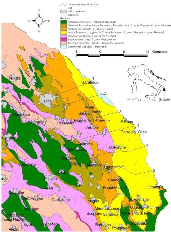
consti-128 S. Margiotta and S. Negri: Geophysical and stratigraphical research Fig.1
Salento
Acquarica
Fig.1
Fig. 1. Location of studied area and geological map.
tutes a important risk factor, since the underground karstic channels may represent routes of rapid and deep saline intru-sion. However, in these studies it emerged that the shortage of information, due to the limited number of points of obser-vation, did not allow for a reliable evaluation of the deterio-ration of underground water resources.
The objective of this work is the physical and stratigraphi-cal characterisation of the subsoil of an Adriatic coastal area
located south of Lecce, and to verify “the state of health” of the aquifer holding the deep waters of Salento. This area was characterised in a previous study (Margiotta and Tadolini, 1987), where the authors carried out geological and hydro-geological research, including multi-parameter surveys of the water-columns of many wells pertaining to the land-improvement consortium known as “Consorzio Bonifica Ugento li Foggi” (CBU).
S. Margiotta and S. Negri: Geophysical and stratigraphical research 129 Our study sought to verify possible changes to the state of
the groundwater with respect to the earlier surveys. Strati-graphical data on existing wells were collected and analysed in the light of new geological knowledge of the territory. The stratigraphic and geological data are kept in the archives of the following local agencies: “Acquedotto Pugliese, Ente Ir-rigazione, Consorzio di Bonifica Ugento li Foggi” and “Con-sorzio di Bonifica dell’Arneo”.
The collected data were organised into a single database managed by an appropriate software (ARCVIEW). In addi-tion, analysis of the rocks was also carried out and numerous geological cross sections of the territory were prepared.
The hydro-geological surveys were carried out in two dif-ferent periods (May and September) in order to identify po-tential differences between rainy and dry periods. The wells considered in this study have never been used either for drinking water or irrigation.
In order to test the reliability of electrical tomography and induced polarisation testing as methods for the characterisa-tion of subsurface geological formacharacterisa-tions and the deteccharacterisa-tion of possible saline water intrusion, geophysical surveys were carried out in an area for which stratigraphical data were al-ready available.
2 Geological and hydrogeological setting
The investigated area represents a complex hydro-geological environment. The Salento is characterised by two aquifers: the first (i.e. the closest to the surface) is made up of Mio-Plio-Pleistocene sediments holding one or more bodies of groundwater. The geometry of the latter is often hard to de-termine, since they lie in limited intervals of permeable rock in a more general context of impermeable deposits. The sec-ond, deep, aquifer is made up of Mesozoic carbonatic forma-tions.
From the abundant literature on the subject (Cotecchia, 1977; Cotecchia et al., 1983, 1998, 2001; Polemio and Limoni, 1995) it comes out that the groundwater contained in the deep aquifer lies entirely on sea water of continental invasion. In cross section, the groundwater has the form of a lens, with its greatest thickness in the centre of the peninsula. The aquifer is highly permeable, and the gradient of the wa-ter table heading towards the sea is extremely low (0.01%– 0.02%). Between the fresh and the salt water there is a tran-sitional layer whose thickness declines as it gets closer to the coast.
A stratigraphical and geological study was also carried out in order to characterise the subsoil. The stratigraphical data from Margiotta and Tadolini (1987) were enriched with data from 200 stratigraphies performed on other wells; the re-sulting integrated database was analysed on the basis of up-to-date geological knowledge of the territory (Bossio et al., 1998, 1999; Margiotta, 1999; Margiotta and Ricchetti, 2002; Margiotta and Varola, 2004). The research and the method-ologies applied have made it possible therefore to measure in detail, for the first time in the literature on this region, the
horizontal area, depth and thickness of the lithostratigraphi-cal formations.
The following litostratigraphic formations, from the most ancient to the most recent, were recognised (Fig. 1):
– Altamura Limestone (Upper Cretaceous) – Galatone Formation (Upper Oligocene)
– Lecce Formation (Upper Oligocene – Lower Miocene) – Pietra Leccese (Lower Miocene – Upper Miocene) – Andrano Calcarenite (Upper Miocene)
– Leuca Formation (Lower Pliocene)
– Uggiano la Chiesa Formation (Lower – Upper Pliocene) – Gravina Calcarenite (Pleistocene)
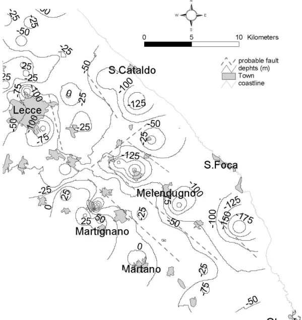
Outcrops of Altamura Limestone are extensive in the area north of Lecce and in the area between Caprarica di Lecce to the north, Zollino to the south-west and Martano to the south-east. These are the highest reliefs in the territory un-der study. This formation is made up of alternating layers of variable thickness of compact limestones and dolomitic lime-stones of white and grey colour. The Cretaceous limelime-stones are characterised by folding along a NNW-SSE axis, locally associated with faults. These phenomena have created a sys-tem of faults forming small horsts (known as “Serre”) and Grabens (Figs. 2 and 3). Karst was able to develop along these lines of structural weakness. The Mesozoic rocks are always very permeable, due to both fracturing and karst, and hold the deep groundwater of Salento.
Galatone Formation (Upper Oligocene) crop out south-west of Lecce and near Otranto. It is characterised by very thin alternating layers of micritic compact grey-white lime-stones, marls and sandy clay deposits. On the whole the thickness of the formation varies between 10 m and 70 m. The permeability of Galatone Formation is variable, due to the variable lithological types.
Lecce Formation (Upper Oligocene-Lower Miocene) is characterised by calcarenites varying from white to light brown, with thickness not greater than 60 m. This formation was previously considered as belonging to the “Pietra lec-cese” formation. Outcrops of this latter are extensive around Lecce, in an area bounded by Strud`a, Vernole and Acaia, and in further area between Martano, Zollino and Maglie. This formation is made up of compact and detrital limestones. Its thickness reaches the maximum value of about 80 m, based upon data from wells.
Andrano Calcarenite is made up of marl limestones and calcarenites of grey colour, with a maximum thickness of 50 m. The calcarenite is sometimes fine-grained and com-pact, while in other cases medium-grained, porous and fri-able.
Uggiano la Chiesa Formation is detritic and carbonatic and crops out along a strip near the Adriatic sea, with maximum thickness just over 50 m.
130 Fig.2 S. Margiotta and S. Negri: Geophysical and stratigraphical research
Fig. 2. Top of the carbonatic Cretaceous basement (elaboration with Arcview software).
As already mentioned, the Miocene and Pliocene forma-tions are practically impermeable, although they may present permeable intervals which allow the formation of groundwa-ter bodies relatively close to the surface.
Gravina Calcarenite is characterised by yellow coarse-grained calcarenites, with frequent macro and microfossils.
The stratigraphies collected highlight the following:
– Particularly important, especially in terms of its
impli-cations for the hydro-geological features of the site, is the configuration of the Cretaceous formation, the upper surface (Fig. 2) of which rarely rises above sea level. The deep groundwater is thus confined in these Cre-taceous deposits by the overlying Miocene sediments (generally impermeable). In the area under study, the Cretaceous sediments contain many faults and form a horst located immediately to the east of Lecce. The top
of this horst is 10–20 m above sea level. In adjacent ar-eas, the Cretaceous sediments are delimited by normal faults along a NW-SE axis (Figs. 2 and 3), and form grabens the tops of which lie up to 150 m below sea level.
– In the area bounded by Lecce to the north, Vernole,
Liz-zanello and Cavallino to the south and the coastline be-tween S. Cataldo and S. Foca to the east, the Oligocene sediments of the Galatone Formation and the Oligo-Miocene sediments of the Lecce Formation reach their greatest thickness (80 m for the continental formation and 60 m for the marine formation); in the same area, the Miocene sediments of Pietra leccese and Andrano Calcarenite also reach significant thickness, about 80 m and 50 m, respectively. Moreover, in the area near the coast, the Pliocene sediments of the Leuca Formation (a
S. Margiotta and S. Negri: Geophysical and stratigraphical research 131 W 50 -200 -150 -100 -50 0 49 s.l. E 10 8 7 5 5 22 13 15 25 30 32 33 34 34 3435 35 35 43 37 40 42 43 44 48 44 M2 M2 M1 10 0 20 0 30 0 Section 1 C 50 0 -50 -100 -150 W Mass. Pezza 43 39 42 41 40 40 39 39 35 36 38 35 3534 30 30 2525 20 17 15 101010 55 5 5 Canale collettore cesine s.l. E Section 2 150 100 -50 -100 -150 -200 50 0 W Mass.S. Alieni 4543 40 40 39 34 40 42 40 39 35 37 36 40 40 38 35 35 30Mass.Dragone25 25 20 15 10 10 65 6 4 s.l. E LECCE San Cataldo Acquarica residual clays DP 4 EI 18 DP 3 CBU 36 EI 15 EI 16 EI 80 MARG. 20 MARG. 19 EI 4 EI 20 100 50 0 -50 -100 -150 W 80 70 65 65 65 60 55 Giard. Mazzarella 51 49 45 45 45 40 39 37 34 Mass. Tartari 30 30 26 20 15 105 1 1 s.l E -50 50 100 0 -100 W 61 60 55 50 52 44 Mass. Chirio 40 35 30 25 20 2025 25 202020 15 15 20 25 25 25 20 20 15 15 15 10 5 3 s.l. Section 5 E 100 50 0 -50 -100 -150 W s.l. 54 55 50 504540 50 45 45 40 35 40 46 45 45 40 3530 20 25153 Alimini Piccolo 01010 20 161515 12 7 Torre S. Stefano E Section 6 AQP 9 EI 38 EI 85 EI 8
CBU 13 CBU 14 CBU 11 EI 84
EI 9 EI 10 CBU 25 EI 531 C M2 M O M1 M P 10 0 20 0 30 0 M1 M O C M2 M1 C M2 M1 C P Section 3 10 0 20 0 30 0 Q M1 C M2 M2 M1 M1 C M2 P M1 M C 10 0 20 0 30 0 Section 4 M1 C Q M2 C M1 M2 M M1 M2 C Q P M2 M1 C 10 0 20 0 30 0 CBU 23 P M2 M1 C M1 C M2 10 0 20 0 30 0 residual clays residual clays O O O O Fig.3 Pisignano
Fig. 3. Geological sections.
few metres) and the Uggiano la Chiesa Formation (up to 50 m) cover the Miocene deposits.
– North of the above-described area, Pietra leccese rests
directly in transgression on a Cretaceous basement, with variable thickness.
– In the area between “Otranto” and “S. Foca”, the
Miocene deposits, resting directly on the Cretaceous limestones, are covered in turn by Pliocene deposits of the Leuca and Uggiano la Chiesa Formations.
In conclusion, the deep groundwater is unconfined in the area north of Lecce where the Mesozoic limestones crop out, and where the outcropping generally impermeable Neogene sediments do not go below sea level. In the rest of the study area, on the other hand, the deep groundwater is generally confined.
3 Hydrological surveying
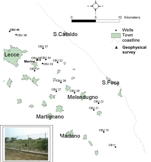
Fifteen multi-parameter measurements were taken in wells bored in the deep groundwater (Fig. 4) located in the area managed by the Consorzio Bonifica Ugento li Foggi (CBU). Two cycles of measurements were carried out: in May 2003, the period when the recharging of the aquifers is at its height, and in September, at the end of the irrigation season and be-fore the winter rains. In the course of the survey the depth of the piezometric level was also measured.
Separate measurements were taken with 1 m pace, collect-ing data on various parameters: O2, pH, temperature, TDS (salinity), conductivity. The probe used was a Hydrolab mini sonde 4 (MS 4). From the hydrological measurements con-ducted, it emerged that:
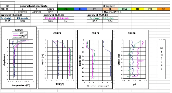
1. In many wells the piezometric level is deeper than in 1987 (Table 1). With the exception of the wells 21, 26 and 28, where there was no significant difference, the piezometric level was between 0.3 and 1.45 m lower. 2. The temperature showed no significant changes (Fig. 5).
132 S. Margiotta and S. Negri: Geophysical and stratigraphical research Fig.4 CBU 36 Geophysical survey Merine CBU 40
Fig. 4. Location of the investigated wells and of geophysical survey.
Table 1. Piezometric levels measured in 1987 and 2003.
Well X Y Z P.L.–1987 P.L.–May 2003 P.L.–Sept. 2003 CBU 11 2810575 4452846 43.69 25.38 21.42 21.37 CBU 15 2808157 4455926 33.65 3.64 3.35 3.22 CBU 21 2806105 4460473 34.78 4.61 4.06 3.94 CBU 22 2807075 4461844 26.20 6.21 5.65 5.80 CBU 26 2802113 4463997 46.56 3.18 2.75 2.75 CBU 27 2798364 4464277 39.98 3.72 4.24 4.05 CBU 28 2799323 4466101 37.20 3.55 3.40 3.04 CBU 31 2793894 4468538 46.35 3.26 2.77 2.81 CBU 32 2798657 4470256 39.21 3.33 3.01 2.97 CBU 33 2795511 4470040 42.20 3.23 2.78 2.78 CBU 34 2796200 4470835 36.71 3.17 2.81 2.85 CBU 36 2795007 4470774 40.01 3.16 2.71 2.71 CBU 37 2795643 4473167 35.85 3.57 3.05 3.05 CBU 38 2790052 4475973 35.92 3.44 2.02 2.02 CBU 40 2788720 4476641 34.96 2.32 1.93 2.01
S. Margiotta and S. Negri: Geophysical and stratigraphical research 133
Fig. 5. Results of survey in the well CBU 28.
3. In many wells (11, 15, 21, 22, 27, 28, 34, 37 and 40), the TDS was 0.2–0.5 g/l higher than in 1987, while in some (26, 31, 32 and 36) it was 1–2 g/l higher.
4. The 2003 dissolved oxygen values were lower than in 1987.
5. The pH in many wells rose slightly, up to 8.
These data show that a generalised diminution of the vol-ume of fresh water available in the area under study is in progress. The lowering of the piezometric levels and the rise in salinity unambiguously show the deterioration in both quantitative and qualitative terms of the water resources, driven essentially by over-exploitation and saline contamina-tion. Furthermore, the pH values, together with the diminu-tion of dissolved oxygen, point to the possibility of pollu-tion deriving from substances from the soil. In order to sup-port this hypothesis it would be necessary to conduct specific chemical and bacteriological tests.
4 Geophysical surveying
Geophysical surveys were carried out in an area near the well 36 (Fig. 4). In addition, we carried out thermo-salinometric surveys. This area was thus selected as a site where the electrical methods (electrical tomography and induced polar-isation) were tested in order to verify their utility in hydro-geological research.
The following arrays were used for resistivity: pole-dipole, Wenner and Wenner-Schlumberger. Forty-eights, 5m spaced, electrodes were used. The Wenner array was chosen because it better identifies the different subsurface geological
formations. The Wenner-Schlumberger array provided hori-zontal and vertical resolution and the pole-dipole array was used to obtain data from deeper levels. For induced polarisa-tion only the pole-dipole array was used.
To obtain 2D resistivity models the experimental data were inverted using the RES2DINV software (Loke, 1999), which uses the rapid inversion algorithm of Loke and Barker, 1996. The 2D resistivity model (Fig. 6a) obtained using the pole-pole array showed four electrical layers:
1. A superficial electro-layer with a depth of about 0–13 m and resistivity values of 60–110 ohm.m;
2. An electro-layer with a depth of about 13–40 m and re-sistivity values of 200–300 ohm.m;
3. An electro-layer with a depth of about 40–50 m and re-sistivity values of 110–220 ohm.m;
4. An electro-layer with a depth of about 50–63 m and re-sistivity values of 50–100 ohm.m.
Considering the stratigraphy shown in Fig. 6c, electro-layers 1 and 2 correspond to the Miocene formation; unfortunately there are not stratigraphical data to distinguish which one of Miocene formation. The lower resistivity values in electro-layer 1 are due to infiltration of rainwater. The resistivity values of electro-layer 2 indicate that it is relatively imperme-able; it thus forms the bed of a superficial, seasonal ground-water body.
The other third electro-layers corresponds, respectively, to the Galatone Formation, and to the aquifer formed by the Cretaceous limestones.
134 S. Margiotta and S. Negri: Geophysical and stratigraphical research
Pollution?
Pollution ?
Falda in pressione
Season water
Electrical layer impermeable
Falda in pressione
Season water Season water
Electrical layer impermeable
Fig. 6
(a)
(c)
(b)
Fig. 6. (a) 2D resistivity model (pole-dipole array); (b) 2D chargeability model (pole-dipole array); (c) Stratigraphic succession of CBU 36
well.
The 2D resistivity models (Fig. 7) obtained using the Wen-ner and WenWen-ner-Schlumberger arrays show more clearly the significant difference in resistivity values between the first and the second electro-layers.
The results of the induced polarisation (Fig. 6b) highlights a 8–20 m thick layer with high chargeability values (7 mV/V– 16 mV/V). This is probably caused by pollution deriving from infiltration from the surface. The results of the elec-trical tomography qualitatively indicate the permeability of the various layers and show the piezometric level of the deep aquifer (about 55 m below the surface). These results are in good agreement with the stratigraphies (Fig. 6c). The re-sistivity values (50–100 ohm.m) also show that the ground-water has low salinity, in agreement with hydrological mea-surements performed on water drawn directly from the well 36. Moreover the induced polarisation method proved to be useful because it highlighted areas possibly affected by pol-lution, in agreement with the data for pH values (about 8) and dissolved oxygen (lower values than those recorded in 1987) and with the observation that the well 36 is near an illegal rubbish dump containing dangerous waste. More de-tailed information on the state of health of the subsoil would require chemical and bacteriological analysis.
5 Conclusions
The surveys conducted for the present study have contributed to characterise the aquifer containing the deep groundwater in the area east of Lecce. They have shown that the
piezomet-ric level has fallen in the period 1987–2003 by an average of 0.50 m (maximum 1.50 m) particularly in the area north and east of Lecce. This observation is very important because the surveys conducted have detected a fault in the Cretaceous Limestones and in the Miocene calcarenites, with a slip of 40–70 m, located near the the built-up areas of Strud`a and Pisignano (Fig. 2 and Sect. 3 in Fig. 3) at southeast of Lecce. This fault probably constitutes a preferential line of drainage for rainwater and favours the local recharging of the aquifer in the area to the south. The lower values of the piezometric level reflect a fall of several metres in the thickness of the deep groundwater. Moreover, a rise in total salinity has been recorded, due to the intrusion of saline water by continen-tal invasion. This increase has implications for domestic and agricultural water supply. The pH values have risen slightly with respect to the data from 1987 but this parameter is not significant given that the values range from 5.0 to 8.5. How-ever, an increase in the pH and a fall in dissolved oxygen concentrations may indicate pollution from the discharge of dangerous substances into the ground, also supported by the results of the induced polarisation tests. The high pH val-ues recorded for the well 36 are supported by the results of the induced polarisation tests. The results of the electrical tomography surveys are in agreement with the stratigraphies (Fig. 6c) and they provide further information on the differ-ing water content of the various formations. These results also show that the deep groundwater lies 55 m below the sur-face and has resistivity values that indicate low salinity, as supported by the analysis of water from the well 36.
S. Margiotta and S. Negri: Geophysical and stratigraphical research 135 Fig.7 Impermeable layer Impermeable layer Seasonal groundwater Seasonal groundwater (a) (b)
Fig. 7. (a) 2D resistivity model (Wenner array); (b) 2D resistivity model (Wenner-Schlumberger array).
In conclusion, the data show that a generalised diminu-tion of the volume of fresh water available in the subsoil of the area under study is in progress. The results of our surveys demonstrate the ongoing process of saline water in-trusion into the deep groundwater, highlighting the need to address the issues of protection, conservation and correct management of the groundwater resources. In an area like Salento which is substantially lacking in superficial water re-sources, the groundwater constitutes the only renewable wa-ter resource.
The results obtained support the use of the methods of electrical tomography and induced polarisation to comple-ment and spatially correlate the data from the various sur-veys and tests, which would otherwise be limited to the in-dividual points where the wells are drilled. Further research, aimed at accurately evaluating the over-exploitation of the underground water resources, would involve an increase in the number of observation points and measurements, and the preparation of a detailed model taking into account the actual permeability of the aquifer, in order to contribute to provide the basis for a correct hydro-geological management of the area. In addition, other studies of a chemical and bacterio-logical nature are required.
Acknowledgements. We are grateful to Cal`o, I., Guerrieri, F.,
Mazzone, F., and Di Paola, M. for their continued support of this research.
Edited by: M. Parise
Reviewed by: M. Delle Rose and another referee
References
Bossio, A., Esu, D., Foresi, L. M., Girotti, O., Iannone, A., Lu-perto, E., Margiotta, S., Mazzei, R., Monteforti, B., Ricchetti, G., and Salvatorini, G.: Formazione di Galatone, nuovo nome per un’unit`a litostratigrafia del Salento (Puglia, Italia meridionale), Atti Soc. tosc. Sci. Nat., Mem., Serie A, 105, 151–156, 1998. Bossio, A., Foresi, L., Margiotta, S., Mazzei, R., Monteforti, B.,
and Salvatorini, G.: Carta geologica del settore nord orientale della Provincia di Lecce; 1:25 000 scale, Siena University, 1999. Cotecchia, V.: Studi e ricerche sulle acque sotterranee e sulla intru-sione marina in Puglia (Penisola Salenitina), IRSA, 20, 1–462, 1977.
Cotecchia, V., Tadolini, P., and Tulipano, L.: Sea water intrusion in the planning of groundwater resources protection and utilization in the Apulian region (southern Italy), Geol. Appl. e Idrogeol., 18, 367–382, 1983.
Cotecchia, V., Dauru, M., and Limoni, P. P.: Osservazioni sull’evoluzione dell’intrusione marina degli acquiferi carbon-atici costieri della Puglia, Workshop “Il degrado qualitativo delle acque sotterranee in Puglia”, 2001.
Cotecchia, V., Dauru, M., Limoni, P. P., Polemio, M., Spizzico, M., and Tadolini, T.: Il controllo idro-chimico fisico della falda idrica carbonatica Murgiano-Salentina (Puglia), Atti della gior-nata mondiale dell’acqua “Acque sotterranee: risorsa invisibile”, 1998.
Fidelibus, M. D. and Tulipano, L.: Inquinamento salino ed antrop-ico degli acquiferi costieri della Murgia e del Salento, Conv. Uso e tutela dei corpi idrici sotterranei pugliesi, Bari, 95–104, 2002. Glenn, E., Smith Stafford, M., and Squires, V.: On our failure to
control desertification: implications for global change issues, and a research agenda for the future, Environmental Science and Pol-icy 1, 71–78, 1998.
136 S. Margiotta and S. Negri: Geophysical and stratigraphical research
Loke, M. H.: Electrical imaging surveys for environmental and en-gineering studies, Users manual for Res2dinv, Electronic version available from http://www.geometrics.com, 1999.
Loke, M. H. and Baker, R. D.: Rapid least-squares inversion of ap-parent resitivity pseudosection by a quasi-Newton method, Geo-physical Prospecting, 44, 131–152, 1996.
Maggiore, M. and Pagliarulo, P.: Circolazione idrica ed equilibri idrogeologici negli acquiferi della Puglia, Workshop ”Uso e tutela dei corpi idrici sotterranei pugliesi”, Bari, 13–36, 2002. Maggiore, M. and Pagliarulo, P.: Siccit`a e disponibilit`a idriche
sot-terranee del tavoliere di Puglia, Geologia dell’ambiente, SIGEA, 11, 35–40, 2003.
Margiotta, B. and Tadolini, T.: Nuovi elementi geoidrologici scatu-riti da perforazioni recenti nell’area posta a sud di Lecce, Quad. Ric. Centro Studi Geot. Ing., 11, 287–302, 1987.
Margiotta, S.: Il contatto Formazione di Galatone – Formazione di Lecce: evidenze stratigrafico – sedimentologiche, Atti Soc. tosc. Sci. Nat., Mem., Serie A, 106, 73–77, 1999.
Margiotta, S. and Ricchetti, G.: Stratigrafia dei depositi oligomiocenici del Salento (Puglia), Boll. Soc. Geol. It., 121, 243–252, 2002.
Margiotta, S., and Varola, A.: Nuovi dati geologici e paleontologici su alcuni affioramenti del territorio di Lecce, Atti Soc. tosc. Sci. Nat., Mem., Serie A, 109, 1–12, 2004.
Polemio, M. and Limoni, P. P.: L’evoluzione dell’inquinamento salino delle acque sotterranee della Murgia e del Salento, VI Conv., Geologia Applicata, 1995.
Tulipano, L. and Fidelibus, M. D.: Evaluation of over – exploita-tion effects for the Salento coastal karstic aquifer through the interpretation of thermo – conductivity logs in observation wells, 2 Symp. On “Protection of groundwater from pollution and sea-water intrusion”, Bari, 1999.
Tulipano, L. and Fidelibus, M. D.: Mechanism of groundwater salinisation in a coastal karstic aquifer subyect to over – exploita-tion, Proc. 17 SWIM, Delft, The Netherlands, 2002.
Zito, G.: La desertificazione: passato, presente e futuro, SIGEA, XI, 2, 7–10, 2003.