Veget Hist Archaeobot (1998) 7:241-249
Vegetation History
and Archaeobotany
© Springer-Verlag 1998
Late-glacial and Holocene vegetation and climate change at the
Palii glacier, Bernina Pass, Grisons Canton, Switzerland
Heinrich Zoller 1, Nikolaos Athanasiadis 2 and Annek~ithi Heitz-Weniger 3 i Botanisches Institut der Universit~it Basel, Sch6nbeinstr. 6, CH-4056 Basel, Switzerland 2 Laboratorium •r Forstbotanik der Universit~it, GR-Thessaloniki, Greece
3 Mfihlestiegstr. 44, CH-4125 Riehen, Switzerland Received March 20, 1998 / Accepted September 18, 1998
Abstract. Pollen and macrofossil data from Alpe Palfi, south-eastern Switzerland, are presented. On the basis of these data and the geomorphological evidence for local glacier movement, Holocene climatic oscillations and vegetation change at this upland site (1940 m asl), are reconstructed. The morainic deposits and glacial clays, as well as the pollen data from the base o f the pollen profile, clearly show that the Palti glacier, after its re- treat from the Cavaglia (Egesen) stade, readvanced once again shortly before the mid-Preboreal. This re-advance was considerably greater than that dating to the Little Ice Age. This early Holocene climatic event is referred to as the Pal/.i Oscillation (Palii-Schwankung) and is consid- ered to be broad][y contemporaneous with the previously described Schlaten Oscillation (Schlaten-Schwankung) in the Austrian Alps. The reforestation of the forefield of the moraine was interrupted at least twice during this os- cillation, and, compared with neighbouring sites at the same altitude, it appears to be at least 500-700 years younger, i. e. it post-dates 9400 B.P. Though the Palti Oscillation is a Holocene phenomenon, the associated vegetation changes are Late-glacial in character, e.g. Ar- temisia and Chenopodiaceae increase and Hippophai~ is recorded. Alnus viridis replaces Betula and Salix, which were important in the earlier part of the Holocene, at about 5000 B.P. There is no clear evidence that forest burning is attributable to human activity. The use o f Larix-dominated areas as pasture (Ldrchwiesen) begins in the mid-Bronze Age. A strong decline in Picea (spruce) and Larix (larch), and an increase in Poaceae, Plantago and other herbs in the uppermost horizons re- flect more intensive pastoral farming that began in the high Middle Ages.
Key words: Pollen analysis - Glacier readvance - Preboreal oscillation - S w i t z e r l a n d - Alps
Correspondence to: H. Zoller
Introduction
In their efforts to study past climate, vegetation and gla- cier history, Swiss palynologists realised at an early stage that it was only by the simultaneous use of biostratigraphical and geomorphological methods that reliable palaeoenvironmental reconstructions could be made (L[idi 1944; Welten 1944, 1952; Zoller 1960; Zoller et al. 1966). Some of the preliminary results pre- sented in the two latter publications motivated G. Furrer to start a large project, at the Geographical Institute, University of Ztirich, which deals with Late-Wiirmian and Holocene palaeoenvironments in the Grisons Can- ton, Swiss Alps (Furrer et al. 1984). This project in- eluded investigations at the Pal~i glacier (Beeler 1977; Figs. 1, 2). While mapping moraines in the vicinity of the Palfi glacier, Beeler found several small bogs, the pollen analytical investigations from one of which are presented here (Alpe Palti; M3, Figs. 2, 3). In addition F. Averdieck carried out pollen analytical investigations in the bog, Galleria da Palii (M2, Figs. 2, 3) which was pub- lished in Beeler (1977). This diagram covers the last 2300 years and is important for the interpretation of the youngest parts of the diagram, Alpe Palii (M3). The base of M2 gave an early Holocene date [zone III/IV; classi- cal zones after Firbas (1949)] which is useful for dating the last readvances of the Palti glacier (Beeler 1977). Burga (1987) published a substantial volume dealing with glacier and vegetation history of the South Raetien Alps since the Late-Wtirmian. This publication contains detailed geomorphological and palynological data relat- ing to the region of the Pal/i glacier. Nevertheless, it seems worthwhile to publish the complete diagrams from Alpe Palii (M3), because the profile shows excep- tionally well the vegetation development of an important glacier forefield at the Pleistocene/Holocene transition and also several interesting changes in the upper subalpine .forests of the central Alps after the retreat of the glacier.
v , \ 8
i
/
5km
Fig. 1. Map of the Bemina Pass and surrounding region (after Beeler 1977). The area covered by the detailed map is indi- cated on the inset map by a solid rectangle. Abbreviations: B, Boval glacier; C, Cambrena glacier; LB, Lago Bianco; M, Mi- nor glacier; MB, Munt Buottels; P, Pers glacier; 1, Chalchagn; 2, Morteratsch; 3, Bernina; 4, Palfi; 5, Cambrena; 6, Sassal- mason; 7, Munt Pers; 8 Languard; 9, Alv; 10, Lagath; 11, Gessi
Site description
At the site Alpe Palfi, two cores, M3 1 and M3 2, were taken from 65 m east o f Lagh da Palfi, i.e. beside the alpine hut (Landeskarte der Schweiz 1:25 000, 1278 La R6sa; coordinates: 799.320/139.035; 1940 m asl; Figs. 2,3). The small bog lies in a flat depression surrounded by rocky outcrops and morainic deposits. Drainage is by a small wet channel between the slope of Alp Grtim and the northern rocky outcrop so that the bog was at least partly dammed by the morainic deposits lying to the east of Lagh da Palfi (Beeler 1977). For the interpretation of the pollen record at the base of the diagram, it should be noted that the alluvial plain and its opening toward the steep gorge o f Asciai da Palfi lies below 1930 m asl. To- day, the bog supports a sedge-dominated community that may be classified in the Caricetum nigrae trichophoreto- sum association. In a 10-m 2 relev6 at the site, the follow-
ing species were recorded (Braun-Blanquet cover/abun- dance values given in parentheses): Carex nigra (3), C. panicea (r), Trichophorum caespitosum (3), Eriophorum angustifolium (+), Potentilla ereeta (r), Pinguicula vul- garis (r), Drepanocladus exannulatus (3) and Caliiergon stramineum (2).
Intensive pasturing has greatly influenced the natural succession in the forefield of the Palti glacier. Outside the moraine o f 1890, transitions from pioneer communi- ties of the Epilobion fleischeri to Poion alpinae grass- lands can everywhere be observed. On the older stages of the Little Ice Age (seventeenth century to 1850) in par- ticular, initial stages of the dwarf shrub Rhododendro- Vaccinion communities have developed, but an ad- vanced succession towards the subalpine podsol climax has not taken place. In the outermost, older parts (system 1), ericoid vegetation is better developed than in the younger parts (system 2-4; after Beeler 1977). The northern slopes of the forefield appear to be very dry. On the inside of these slopes, there are just a few small Larix trees, while on the north-facing parts, Larix trees attain a height not exceeding 5-7 m. In the southern parts of the forefield, increased soil wetness is indicated by several specimens of Alnus viridis, some patches o f tall herbs (Adenostylion) and strongly growing Larix specimens on north-facing slopes.
Outside the moraines dating to the Little Ice Age, the region of Alpe Palfi is more or less covered by forests where Larix is dominant. There are occasional speci- mens of Picea abies and Pinus cembra (Swiss stone pine). As a consequence o f human activity over at least 3500 years, only a few remnants of the formerly closed, subalpine, coniferous forests remain. The understory of these forests consists of dwarf-shrub communities (Rhododendro-Vaccinion) at the northerly exposed slopes. On the sunny slopes, a mosaic o f Juniperus alpina and Festuca acuminata forms the ground layer of the open larchwoods. A. viridis is rather inconspicuous and grows mainly with Sorbus aucuparia on the shaded slopes to the south o f Acqua da Palti. Willows (Salix spp.) are infrequent on the forefield and in the areas ad- jacent to the Palti glacier. The present-day alpine timber- line at Alpe Palti fluctuates between 2000 m on the slopes of the valley and ca. 2170 m on the slopes to the north of Alp Grfim. There are many indications that the climate-determined timberline in the Bernina Pass re- gion lies between 2250-2300 m or somewhat higher (Burga 1987).
On the alluvial plain immediately in front o f the subrecent moraines, a mosaic consisting o f communities on gravels (Epilobion fleischeri), pastures (Poion alpinae) and wetlands (Caricion nigrae) covers the flat surface, and there are spring-associated communities (Cratoneuro-Philonotidetum seriatae) along the many water channels.
Cores, stratigraphy, radiocarbon dating and pollen
analysis
Sampling, which was carried out in 1974, was particu- larly difficult because o f the woody remains at depths 90-320 cm (details in Beeler 1977). The uppermost 3 m
243 of peat was sampled continuously from an undisturbed
peat face prepared by Beeler and collaborators by dig- ging a pit. Below this, sampling was carried out to a depth of 650 cm using an improved Dachnowsky corer. Thus the profile consists of two parts, i.e. an upper part, Palfi M3 2, 0-290 cm, and a lower part, Palii M3 1,285- 650 cm). Details of the stratigraphy and radiocarbon dat- ing are given in Tables 1 and 2, respectively.
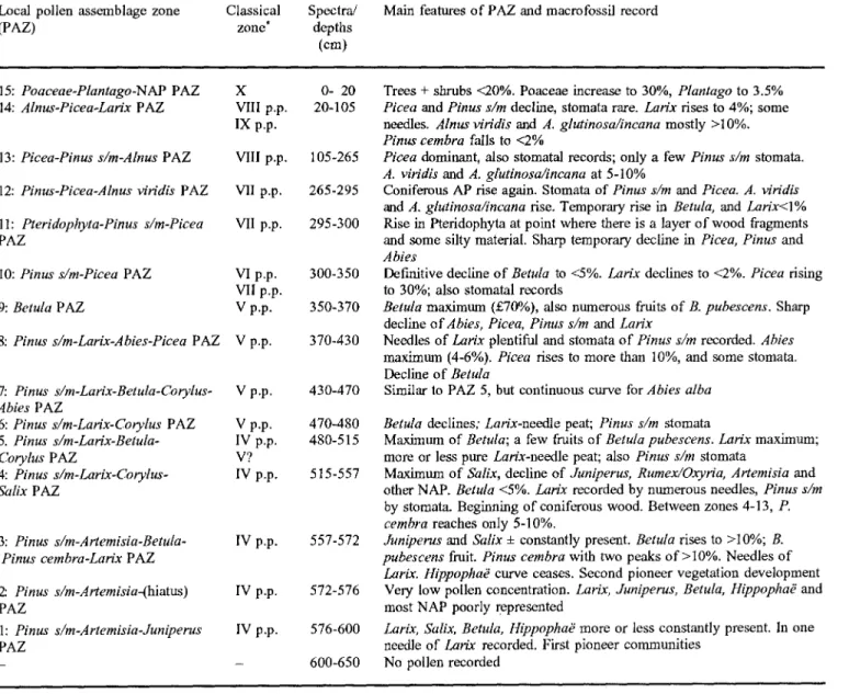
The pollen analytical results are presented in two dia- grams, i.e. M3 1 and M3 2 (Fig. 4). The main features of the pollen profile and also macrofossil results are sum- marised in Table 3.
D i s c u s s i o n
From the Palii Oscillation "Palfi-Schwankung" to r~for- estation (650-555 cm)
The blue silty, pollen-free silt/clay at the base (650-600 cm) indicates that the site lies immediately in front of the PaliJ glacier (500 m from the outer slopes of the mo- raine which dates to the seventeenth century). Unfortu- nately, the end moraines of this stade have not been identified (Beeler 1977). The glacier tongue probably lay during this period in t]he Asciai da Palii gorge where there was no moraine deposition. Sedimentation of fine plastic silt/clays (GlaziaIton) was only possible if the PaHi glacier reached the area now covered by bog to the
east of the Lagh da Palii, because even the base of the profile lies several metres higher than the surface of the alluvial plain in front of the subrecent moraines.
At ca. 600 cm (base of the diagram M3 1), pioneer plant succession started and was later interrupted and delayed by several climatic oscillations. The first pio- neer phase is reflected by high percentages of Artemisia and Chenopodiaceae followed by a maximum of Rumex/ Oxyria. Meanwhile, Juniperus achieves a peak of ca. 8%, HippophaY and Salix are constantly present, Larix reaches 2% and two Larix leaves are recorded. Further- more, the silt/clays are largely replaced by organic mate- rial (gyttja). This demonstrates clearly a rapid succes- sion towards reforestation. However, this development seems to be abruptly halted by a practically pollen-free layer between 575-570 era, where again clays and silts predominate. How far the glacier advanced during this period is not exactly known but the fine mineral matter proves that the edge o f the glacier was close by and hence the vegetation around the site was strongly af- fected.
Above 570 cm, herbaceous communities with Ar- temisia and Rumex/Oxyria as well as shrub communities with Juniperus and Hippopha6 regenerated. Numerous fruits of B. pubescens and needles of Larix indicate the presence of woody shrubs and trees beside the site. P. cembra later attains maximum representation for the profile as a whole (ca. 10-12%), immediately before the
r-- / ~. ~ - . _ _ r - \ _ . ~ cs C a v a g l i a s t a d e f P P a l e s t a d e o 3oo m . . . ~'~" - ~ - - J " ( ~ Bog G ~ Pits / / "J / J / i I I i i - - I I I I _ ~ - . . - ~ I / I ~ J " ~ ~ k /.~b ~ ~ / , /1" 64 " " ~ . ~ " . CS% / / 1 , 2 , 3 ) , . G f I / ".. / / / / / t / " ~ \ " ' .no@" P /" \
'
',
\ <
%
"~ J J ~ 3 :...?.?.:.).:,. \ ,,. "-, , \ ~ ~ v ... --3 "... \ CS \ \Table 1. Details of peat stratigraphy at sampling point
M3 2 (upper part)
0 - 5 Highly decomposed sedge peat 5 - 20 Highly decomposed sedge peat
20 - 90 Highly decomposed sedge peat with some mosses 90 -107 Poorly decomposed sedge peat
107 -135 Highly decomposed sedge peat 135 -165 Poorly decomposed sedge peat 165 - 185 Highly decomposed sedge peat 185 -290 Poorly decomposed sedge peat 285 -290 Sandy, poorly decomposed sedge peat M3 1 (lower part)
285 -325 Poorly decomposed sedge peat 325 -380 Highly decomposed sedge peat
380 -425 Highly decomposed sedge peat with many larch needles
425 -430 Poorly decomposed sedge peat 430 -500 Larch needle peat
500 -520 Highly decomposed sedge peat with layers of larch needles
520 -530 Highly decomposed sedge peat with many larch needles
530 -555 Poorly decomposed sedge peat with layers of larch needles
555 -560 Silty peat
560 -568 Gyttja with silty layers 568 -576 Gyttja
576-578 Silty gyttja 578 -585 Sand 585 -600 Silt
600 -650 Clayey silt; sand and gravel prevented further coring
two pronounced peaks o f Artemisia. This suggests local
presence o f the Swiss stone pine. As regards the Artemi- sia peaks, these coincide with increased mineral matter
and the Larix curve behaves in the opposite manner. It
seems plausible to suggest that reforestation has been delayed once again, most likely as a result o f climatic oscillations.
The radiocarbon date 9460±140 B.P., which relates to the twin Artemisia peaks, indicates that retreat o f the
PaIfi glacier from the vicinity o f bog M3 did not occur before the middle Preboreal. It is recorded in many sites that the rise o f Corylus took place during the second half
o f the Preboreal and in several profiles Artemisia is well
represented during the first part of the Preboreal. Fre- quently, Artemisia declines just before the rise o f
Corylus and often ends after Corylus has increased.
Though there is considerable variation in the ~4C dates attaching to this climatic event (Table 4), it is clear that the complex Palfi Oscillation ended shortly before the middle Preboreal. On the other hand, we do not have a satisfactory date for its beginning. It is obvious that it is certainly younger than the Cavaglia stade o f the Pal/.± glacier but b y h o w much remains an open question. The minimal age o f 9690 B.P. which Beeler (1977) got at the base o f bog M1, close to a lateral moraine of the Cavag- lia stage (CS, Fig. 2), seems to be several centuries too young. The lack o f fine glacial clay at the base of this
site suggests that organic sedimentation began distinctly later than the retreat o f the Palfi glacier from the Cavaglia stade. Hence the date, 9690 B.P., cannot corre- spond with the end o f the Cavaglia stade.
Beeler calculated that a depression o f the snow line by 160-240 m was required for the advance o f the Palfi glacier to the moraines o f Cavaglia. That means that the Cavaglia stade must be c o m p a r e d with the classical Egesen stade in Austria which happened during the Younger Dryas (ca. 10 200 B.P., Patzelt 1972, 1977). Consequently the retreat o f the Palfi glacier from the Cavaglia stade, the readvance to bog M3 (Palfi Oscilla- tion) and the advance and retreat in vegetation develop- ment prior to reforestation proper must have occurred during a period of, at most, 700-800 years.
According to Beeler (1977), the retreat o f the Palfi glacier from Cavaglia to the plain o f Alpe Palfi lasted at least two or three centuries. The readvance to M3 is later than the end o f Younger Dryas so therefore the tripartite
Table 2. Details of conventional radiocarbon dating
Pro- 1~2 Lab. Material dated Depth (cm) file No.
Age (B.P.)
M1 UZ-46 Gyttja Base
(335-358)
M2 Ki-670 Cyperaceae peat 100 (sandy)
Hv-5041 Soil
M3 B-2995 Cyperaceae peat B-2498 Lar/x root B-2779a Picea wood
B-2779a2 Picea wood
(2 "d dating) B-2880 Picea wood
B-2779i Picea wood
B-2645 Silty gyttja Immediately below peat/ mineral soil interface 20-25 110 ca. 285 ca. 285 ca. 300 ca. 300 560-565 9635 + 160 2290 ± 65 2390 :k 90 1530 ± 70 3680 ± 100 4970 ± 80 * 5010 ± 90 * 5210 ± 70 * 6380 ± 70 ** 9460 :~ 140
* Material from outer part of stem ** Material from centre of stem
) Fig. 4a. Percentage pollen diagram M3 1. Curves for the main woody taxa (left side), a summary diagram (centre) and main NAP curves (right side) are shown. In each case, a total terres- trial pollen sum (excluding hydrophytes and indeterminate taxa) is used. Abbreviations: ABI, Abies; ACE, Acer; COR, Corylus; FRX, Fraxinus; HIP, Hippoha~; JUN, Juniperus: LAR, Larix, QUE, Quercus; SAL, Salix; TIL, Tilia; ULM, Ulmus; curve ~ Pinus cembra: ART, Artemis±a; CAM, Campa-
nulaceae; CAR, Caryophyllaceae; CHE, Chenopodiaceae; C.L., Compositae Liguliflorae; CLT, Caltha; C.T. Compositae
Tubuliflorae; ERI, Ericaceae; HYD, Hydrophyta; IND, Inde- terminata; PLA, Plantago; PTM, Pteridium; RAN, Ranuncu-
laceae; RUB, Rubiaceae; RUM, Rumex; ROS, Rosaceae; SAX,
Saxifraga; THA, Thalictrum: ~ Umbelliferae; VAR,
Varia, stratigraphic legend follows F~gri and Iversen 1950,
I NO VAR HYO P T n RRT C . 1 C.L CRM RUB ERI uns R05 SRX THR CLT RRN CRR CHE RUfl JUN SRL H I P COR RCE FRX
phenomenon, the plant succession shows distinct late- glacial characteristics like the occurrence of Ephedra, Hippophai~ and high percentages of Artemisia.
Since the middle Preboreal, the Palii glacier never again extended close to bog M3. Furthermore, no traces of moraines can be found which might have been formed during Holocene cold phases such as Venediger/ Oberhalbstein, Misox/Frosnitz, Piora/Rotmoos, L6bben and G6schenen I and II [for age of these fluctuations see Burga and Perret (1998)]. Even during the Little Ice Age, the Pall1 glacier did not re-advance to this degree. From r~orestation to the expansion of Picea abies and Alnus viridis (560-290em)
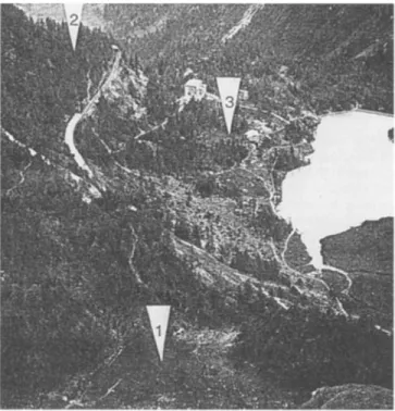
Fig. 3. Photograph showing the bogs M1, M2 and M3 where pollen analytical investigations have been carried out (photo- graph by Beeler, 1977)
Palti Oscillation certainly relates to the early Holocene. It can be correlated with the Schlaten Oscillation which is recorded in the Austrian Alps by well developed moraines. On the basis of the available ~4C dates, it re- lates to the middle Preboreal (Patzelt and Bortenschlager 1973).
Burga (1987) found indications of the Pal~i Oscilla- tion at two neighbouring sites:
1. Buottels where there is a NAP peak in 185 cm, and 2. Plansena where there is strong representation of Ar-
temisia, Asteraceae-Cichorioideae and Saxifraga at 238-228 cm. On the basis of the ~4C date 9200±90 B.P. from 232-327 cm, the transition from silt to silty gyttja at 241 cm and the rise of Corylus at 230 cm, the upper boundary of the Younger Dryas may be drawn at 241 era. A similar delay in reforestation as at Alpe Palii seems to have taken place at Plansena because of its situation close to a landslide and the accumulation of debris and gravels.
It is clear that trees and forests spread up to, or at least close to, altitudes corresponding to those of the recent timberline under the favourable conditions pertaining at the beginning of the Holocene (cf. Welten 1982a). How- ever, Wick and Tinner (1997) suggested recently a de- cline of the alpine forest limit in the middle Preboreal at Gouill6 Rion (Valais) and at Lago Basso (Splfigen) which obviously corresponds with the Palfi Oscillation. Effects of this unfavourable phase have been observed even in the lowlands south and north of the Alps (Behre 1978; Schneider and Tobolski 1985; Lotter et al. 1992). In Maloja, at a comparable altitude, the reforestation took place between 10 000-9800 B.P. (Heitz-Weniger et al. 1982). Delay in reforestation at Alpe Palfi is at least 500 years. Though the Palii Oscillation is a Holocene
In Palti M3 1, the establishment of trees is especially well documented by the rapidly increasing number of Larix needles in the peat. Though Pinus s/m, i.e. Pinus sylvestris and/or P. mugo pollen, dominates the pollen record, larch was probably the dominant tree in the vi- cinity of the site, particularly during the time when an almost pure Larix-needle peat was forming (500-430 cm). The development, from an open to a closed larch forest, is clearly shown by the decline in Salix from rela- tively high representation to low values (2-3%) at the base of the Larix-needle peat. It should be noted, how- ever, that in the period after human impact begins to reg- ister, Salix representation remains less than 0.5% from which it may be concluded that willows were much more important on the moraine forefield during the early Holocene reforestation than during the Little Ice Age.
Compared with the pollen record from Plansena (1892 m) and Aurafreida III (2140 m), the representation of P. cerebra (<10%) is remarkably low at Alpe Palii. According to Burga (1987), P. cerebra increases in the early Holocene at Plansena to more than 40% and is dominant during the whole of the Boreal. In Aurafreida III, P. cerebra is also much more frequent than at Alpe Palfi. This might explain why, in the Alpe Palii profile, a sharp decline in P. cerebra, similar to that in Aurafreida III is not recorded. This event in Aurafreida III is corre- lated by Burga (1987) with the cold phase of Venediger/ Oberhalbstein during the early Boreal.
Of special interest is the course of the Betula curve. After a depression during the late Preboreal, it peaks ini- tially to almost 20%. This feature may be comparable to the Betula/Poaceae maximum at 190 cm in Plansena. In M3 1, however, the corresponding depression of P. cembra is lacking. Consequently, it is not sure if the equivalent of the cold phase of Venediger/Oberhalbstein can be seen in the Alpe Palti profile. Later, after a short depression, the Betula curve again fluctuates between 12-25%. Shortly after the rise in Picea and Abies, it in- creases further and attains 70% (360 cm). The similarity of the Betula curve at Alpe Palti and Plansena cannot be ignored. In both instances, soon after the simultaneous rise of Abies and Picea, Betula also rises in Plansena to achieve almost 70%. At both sites, a sharp but short de- cline in all conifers corresponds with this Betula phase. Burga (1987) connected this Betula peak with the cold phase of Misox/Frosnitz which lasted from ca. 7500- 6500 B.P..(cf. Zoller 1960). However, the ~4C date 5990± 110 B.P. from 380-400 cm, i.e. just below the Betula maximum, is 500 years younger than the end of the cold phase of Misox/Frosnitz. This date may not, however, be
246
Table 3. Zonation and main features of the pollen profile
Local pollen assemblage zone Classical Spectra/
(PAZ) zone" depths
(cm)
Main features of PAZ and macrofossil record
15: Poaceae-Plantago-NAP PAZ 14: Alnus-Picea-Larix PAZ
13: Picea-Pinus s/m-Alnus PAZ
12: Pinus-Picea-Alnus viridis PAZ
11: Pteridophyta-Pinus s/m-Picea PAZ
10: Pinus s/m-Picea PAZ
9: Betula PAZ
8: Pinus s/m-Larix-Abies-Picea PAZ
X 0- 20 VIII p.p. 20-105 IX p.p. VIII p.p. 105-265 VII p.p. 265-295 VII p.p. 295-300 Vip.p. 300-350 Vllp.p. V p.p. 350-370 V p.p. 370-430 7: Pinus s/m-Larix-Betula-Corylus- V p.p. Abies PAZ
6: Pinus s/m-Larix-Corylus PAZ V p.p.
5. Pinus s/m-Larix-Betula- IV p.p.
Corylus PAZ V?
4: Pinus s/m-Larix-Corylus- IV p.p.
Salix P AZ
3: Pinus s/m-Artemisia-13etula-
Pinus cembra-Larix PAZ
2 Pinus s/m-Artem&ia-(hiatus) PAZ 1: Pinus s/m-Artemisia-Juniperus PAZ 430-470 470-480 480-515 515-557 IV p.p. 557-572 IV p.p. 572-576 IV p.p. 576-600 - 600-650
Trees + stmabs <20%. Poaceae increase to 30%, Plantago to 3.5%
Picea and Pinus s/m decline, stomata rare. Larix rises to 4%; some needles. Alnus viridis and A. glutinosa/incana mostly >10%.
Pinus cerebra falls to <2%
Picea dominant, also stomatal records; only a few Pinus s/m stomata.
A. viridis and A. glutinosa/incana at 5-10%
Coniferous AP rise again. Stomata of Pinus s/m and Picea. A. viridis
and A. glutinosa/incana rise. Temporary rise in Betula, and LaHx<l% Rise in Pteridophyta at point where there is a layer of wood fragments and some silty material. Sharp temporary decline in Picea, Pinus and
Abies
Definitive decline of Betula to <5%. Larix declines to <2%. Picea rising to 30%; also stomatal records
Betula maximum (£70%), also numerous fruits of B. pubescens. Sharp
decline of Abies, Picea, Pinus s/m and Larix
Needles of Larix plentiful and stomata of Pinus s/m recorded. Abies maximum (4-6%). Picea rises to more than 10%, and some stomata. Decline of Betula
Similar to PAZ 5, but continuous curve for Abies alba
Betula declines; Larix-needle peat; Pinus s/m stomata
Maximum of Betula; a few fruits of Betula pubescens. Larix maximum; more or less pure Larix-needle peat; also Pinus s/m stomata
Maximum of Salix, decline of Juniperus, Rumex/Oxyria, Artemisia and other NAP. Betula <5%. Larix recorded by numerous needles, Pinus s/m by stomata. Beginning of coniferous wood. Between zones 4-13, P.
cembra reaches only 5-10%.
Juniperus and Salix 4- constantly present. Betula rises to >10%; B.
pubescens fruit. Pinus cerebra with two peaks of >10%. Needles of
Larix. HippophaY curve ceases. Second pioneer vegetation development
Very low pollen concentration. Larix, Juniperus, Betula, Hippopha~ and most NAP poorly represented
Larix, Salix, Betula, Hippopha~ more or less constantly present. In one needle of Lar/x recorded. First pioneer communities
No pollen recorded
* Classical zones after Firbas (1949)
reliable and should be rejected (see below). Correspond- ence with the Misox/Frosnitz phase can be justified by the t4C date 8040±120 B.P., which dates the rise o f P i c e a at Selva ( B u r g a 1987). It is therefore c o n c l u d e d that
Betula peaks shortly after the rise o f Picea at both Alpe Palfi and Plansena, i.e. soon after 7500 B.P. or the zone VI/VII boundary.
Consideration s h o u l d also be given to the factors giv- ing rise to the B e t u l a phase. Possible factors include a short period o f u n f a v o u r a b l e climate, human activity or avalanches. In the Alpe Palfi profile, evidence o f human influence is noted only in m u c h y o u n g e r horizons (see below). I f it were an avalanche, w o o d f r a g m e n t s and some inorganic material might be expected in the sedi- ment, but no traces o f such were observed. On the other hand, the pteridophyte peak at 290 cm m a y be caused b y an avalanche. The m a n y large w o o d fragments between 90-320 cm indicate that m a n y trees were broken or even uprooted and logs, trunks and roots were transported, to-
gether with s o m e inorganic matter, onto the bog. Fur- thermore, the pteridophyte phase corresponds with a dis- tinct increase in sand within the peat (285-290 cm). Af- ter this sudden death o f conifers caused by a local disas- ter, ferns flourished for a short period until the forest re- generated. R a d i o c a r b o n dates f r o m several pieces o f
Picea timbers from b e t w e e n 2 8 5 - 3 0 0 cm support this conclusion. Outer w o o d f r o m three P i c e a stems differ only b y 240 years (4970-5210 B.P.). W o o d from the cen- tre o f a Picea trunk gave a date o f 6380~70 B.P. which suggests that the tree in question was at least 1200 years old.
The period between the ~4C dates, 4970 and 5210 B.P., when the trees were killed, corresponds to the mid- H o l o c e n e cold phase o f P i o r a / R o t m o o s (Zoller 1960; > Fig. 4b. Percentage pollen diagram M3 2. For conventions fol- lowed see Fig. 4a
VRR HY3 PTPi RRT C.T C.L CRM RUB PL R ER I uns ROS S R X THR CL T RRN CRR CHE Run 6 SRL E COR b- RCE n cr) FRX + T I L I- QUE FRG
247 Table 4. Sites at which Corylus increases and Artemisia de-
clines between 9200-9600 B.P. in subalpine and alpine pollen diagrams
Site Author
Simplon (Hopschensee II, 2017 m) Breil/Brigels (Vorderrhein, 1520 m) Segnes (Vorderrhein, 1880 m) Bedrina (Leventina, 1235 m) Acquacalda (Lukmanier, 1730 m) Campra (Lukmanier, 1420 m) Stir (Oberhalbstein, 1780 m) Stallerberg (Oberhalbstein, 2450 m) Lago di Annone (Brianza, 226 m Pian di Gembro (Aprica, 1370 m) Selva (Poschiavo, 1892 m) Alpe di Palii (Bemina, 1940 m)
Welten (1982a) MfiUer (1972) Miiller (1972) Kiittel (1977) Mfiller (1972) Miiller (1972) Heitz (1975) Heitz (1975) Wick (1996) Zoller eta/. (1977) Burga (1987) Palii M3 1 (this publication)
Sites are listed according to geographical location from south- west to north-east
Patzelt 1972; Patzelt ancl Bortenschlager 1973). In sev- eral profiles, this cold phase is well marked by a strong decline in Picea and A. viridis and a substantial increase
in NAP (Zoller 1960; Burga 1993; Wick and Tinner 1997; Burga and Perret 1998). But at PaliJ no distinct signs o f a climatic change, such as increased representa- tion o f d w a r f shrubs and alpine pioneer plants, were noted in the pollen record. It may be purely a coincident that the avalanche catastrophy at Alpe Palii happened during the cold phase o f Piora/Rotmoos, but it is likely that avalanche frequency was considerably higher during this phase o f unfavourable climate. It should also be noted that no traces o f fire, such as charcoal, were noted so that it is highly unlikely that human activity was re- sponsible.
From the expansion of Picea and A, viridis to the first evidence of early human impact
Compared with the subalpine diagrams from Poschiavo and Oberengadin, later developments at Alpe Palti show some distinctive features. At most sites, P.
cerebra dominates in zones V and VI and, subsequently, Picea achieves higher values (much o f zones VII and
VIII; Keller 1930; Kleiber 1974; Heitz-Weniger et al. 1982). In the course o f zones IX and X, P. cerebra is
once again dominant in the Oberengadin, mainly as a re- sult o f climatic deterioration during the later Iron Age and partly as a result o f human impact, especially clear- ing of spruce on the better soils (Zoller and Brombacher 1984).
At Alpe PalfJ, P. cerebra achieves highest representa-
tion (12%) during the reforestation phase in zone IV. Later, it never attains more than 8%. The Alpe Palfi pro- file clearly shows that spruce took the place o f larch and pines (Pinus sylvestris or P. mugo). It should be noted
that, parallel to the rise of Picea, the peat changes gradu-
ally from predominantly consisting o f Lar/x needles (515-420 cm) to sedge peat (from 380 cm upwards) in which no Larix needles are recorded. Also, the slow de-
cline in Pinus s/m pollen from ca. 45% (410-420 cm) to
less than 20% (260 cm) should be noted. This trend ends when spruce finally started to dominate. According to Brockmann-Jerosch (1907), P. mugo is rare on the sili-
ceous soils in the vicinity o f Alpe Palfi while P.
sylvestris does not occur in the upper valley o f
Poschiavo. Representation at 10-20% during the spruce phase suggests that one or both were still present in the vicinity of the Palii glacier.
It is noteworthy that Picea (20-30% when dominant)
was distinctly less frequent at Alpe Patti than at the adja- cent sites o f Plansena (35-50%) and Aurafreida (30- 45%) (Burga 1987). During the same period, NAP at Alpe Palti are noticeably higher (6-15%). This suggests that the forests at Alpe Palii were more open which may be due to cold katabatic winds from the Palii glacier.
As in the profiles from Pian di Gembro Aprica (Zoller et al. 1977) and Selva Poschiavo (Burga 1987),
Abies increased together with Picea. There is no doubt
that Abies penetrated far into the valley at Poschiavo
where it is still present in the lower part (Brockmann- Jerosch 1907). According to Burga (1987), it is certain Eastwards o f a line running through the valley of the Inn
from Landeck to Maloja and from there south-westwards to the Valtellina, Picea spread during zone V (Boreal
period; between ca. 8000-7500 B.P.). At sites near Alpe Pal(i, the spread o f Picea also falls within this period
(Table 5). At Alpe Palii, however, the rise in Picea to ca.
15% is almost 2000 years younger than in adjacent pro- files. Even if the spread o f Picea towards the high and
glaciated Bernina massif was considerably delayed, the difference in the dates from Selva and Alpe Palfi, which are only 10 km apart, cannot readily be explained. The dates from 285-290 cm and 380-400 cm are inverted so that there are no reliable dates for the rise of Picea nor o f A. viridis. The spread o f spruce at Selva has been dated
to 8040 B.P. (Table 5) and this date, which fits fairly well with the results from adjacent sites, is probably also applicable to Alpe Palft.
Table ft. Dates for the rise in Picea between Oberengadin and
Passo Tonale
Site Altitude Age Source
(13) (t~.P.) Maloja St. Moritz Alpe Pala (Bernina) Selva (Peschiavo) Pian di Cembro (Aprica, D 1973) Pian di Cembro (Aprica, D 1975) Passo di Tonale 1830 7700 Heitz-Weniger et al. 1982 1850 8000 Heitz-Weniger et al, 1982 1940 5 9 9 0 D i a g r a m M3 1 1470 8040 Burga 1987 1360 8610-7150 Zoller et al. 1977 1360 8040-6920 Zoller et al. 1977 1880 8200-7600 Gehrlg 1997
that fir reached Selva above Poschiavo at 1470 m. In the Alpe Palfi profile, two noteworthy peaks in Abies are re- corded, the first one at 400 cm (6% in zone VI) and much later in zone IX (Roman period) a second peak (4%) is recorded. At the top o f M3 1, Abies is less than 0.5%. Fir may therefore have reached the uppermost parts o f the Poschiavo valley during zones VI or IX but, unfortu- nately, there are no records o f stomata, needles or wood to support this contention.
Towards the end o f zone VII, A. viridis increasingly replaces Betula and Salix. A. viridis achieves maximum expansion at AIpe Palfi shortly after the peak in ferns at ca. 5000 B.P. High values are also recorded in several profiles at about the same time (Zoller 1960; Zoller and Kleiber 1971; Burga 1980, 1987; Wick and Tinner 1997) but, at Alpe Palfi, the increase in A. viridis is rather sub- dued (generally <10%, max. 12%). This is not surprising since A. viridis achieves limited expansion only in the dryer parts o f the central Alps (Zoller 1995).
From early human impact to modern times
Between 110-90 cm in the Alpe Palfi profile, the follow- ing important changes take place in the pollen record: (1) increase of Larix needles in the sedge-peat and a con- siderable rise in Larix representation (from <1% to al- most 5%); (2) increase in A. viridis to >10%; (3) a sharp decline in Picea and Pinus s/m; and, (4) noticeably higher amounts o f Poaceae, Rumex, Artemisia and Plan-
tago.
Evidently, the Picea and Pinus-dominated forests, which previously covered Alpe Palfi, were replaced by pasture forests in which Larix was important
(Liirchwiesen) as is recorded for the whole o f the
Engadine region [I1 Fuorn in Welten (1982b); St. Moritz in Zoller and Brombacher (1984); Susch, Ardez and Ramosch in Zoller et al. (1996)]. Larix stands appear to have been widely planted in Engadine beginning in Neolithic times, i.e. since ca. 5600 B.P. The ~4C-dated
Larix root at 110 cm (3680±100 B.P.) suggests that the
first Larix stands attributable to human intervention at Alpe Palfi relates to the middle Bronze Age. This agrees with the evidence from the Bernina Pass region where the oldest larch pasture at Ofenpass has been dated to shortly after 4000 B.P. (Welten 1982b). A later anthro- pogenic Larix stand at Alpe Palfi is recorded in the pro- file M2 by F. Averdieck (Beeler 1977).
The severe forest clearances which took place during the Middle Ages can be recognized in the two uppermost horizons o f diagram M3 2. The curves o f all trees and shrubs, Larix included, decline to negligible values while Poaceae rise to >30% and Plantago to 3.5%. This suggests intensive pastoral activity at Alpe Palfi. In the profile M2 by F. Averdieck, this most recent phase o f intensive land use appears to be less well represented (see Beeler 1977, p. 207, Fig. 29). In profile M2, the ex- pansion o f juniper shrub, which today dominates in the dry parts o f Alpe Palfi, is clearly recorded. It is probably a recent development, at least in the immediate vicinity of site M2.
References
Beeler F (1977) Geomorphologische Untersuchungen am Sprit- trod Postglazial im Schweizerischen Nationalpark und im Beminapassgebiet (Sfidrfitische Alpen). Ergebn Wiss Unters Schweiz Nationalpark 115, 77:131-276
Behre KE (1978) Die Klimaschwankungen im europ/iischen Prfiboreal. Petermanns Geogr Mitt 2:97-102
Bortenschla~ger S (1984) Beitrfige zur Vegetationsgeschichte Ti- rols I: Inneres Otztal-unteres lnntal. Ber Nat Med Ver Inns- brock 71:19-56
Brockmann-Jerosch H (1907) Die Flora des Puschlav und ihre Pflanzengesellschaften. Engelmarm, Leipzig
Burga CA (1980) PoUenanalytische Untersuchungen zur Vege- tationsgeschichte des Schams und des San Bernardino- Passgebietes (Grauh/inden, Schweiz). Diss Bot 56:1-194 Burga CA (1987) Gletscher- und Vegetationsgeschichte der Siid-
r/itischen Alpen seit der Spfiteiszeit. Denkschr Schweiz Natur- forsch Ges 101:1-162
Burga CA (1993) Das mittelholozfine Klimaoptimum Europas. Palynologische Untersuchungen an einem ehemaligen hoch- gelegenen Moor am Rutor-Gletscher (Aosta-Tal, Italien). Diss Bot 196:335-346
Burga CA, Perret R (1998) Vegetation trod Klima der Schweiz seit dem jfingeren Eiszeitalter. Ott-Verlag, Thun
F,'egri K, lversen J (1950) Text-Book of modem Pollen Analysis. Munksgaard, Copenhagen, 168 pp
Firbas F (1949) Sprit- und nacheiszeitliche Waldgeschichte Mit- teleuropas n6rdlich der Alpen, 1. Fischer, Jena
Furrer G, Maisch M, Burga CA (1984) Obersicht zur sprit- trod postglazialen Klima-, Gletscher- und Vegetationsgeschichte GraubiJndens. Diss Bot 72:87-115
Gehrig R (1997) Pollenanalytische Untersuchungen zur Vegeta- tions- und Klimageschichte des Val Camonica (Norditalien). Diss Bot 276:1-152
Heitz C (1975) Vegetationsentwicklung nnd Waldgrenzschwan- kungen des Sp/it- und Postglazials im Oberhalbstein (Grau- bfinden, Schweiz) mit besonderer Berficksichtigung der Fichten- einwanderung. Beitr Geobot Landesaufn Schweiz 55:1-63 Heitz-Weniger A, Zoller H, Punchakunnel P (1982) Vegeta-
tions-, Klima- und Gletschergeschichte des Oberengadins. Phys Geogr 1:157-179
Keller P (1930) Postglaziale Waldperioden in den Zentralalpen Graub/indens. Beih Bot Centralbl 46:385-489
Kleiber H (1974) Pollenanalytische Untersuchungen zum Eis- rfickzug und zur Vegetationsgeschichte im Oberengadin I. Bot Jahrb Syst Pflanzengesch Pflanzengeogr 94:1-53
K/ittel M (1977) Pollenanalytische und geochronologische Unter- suchungen zur Piottino-Schwankung (Jfingere Dryas). Boreas 6:159-274
Lotter AF, Eicher U, Siegenthaler U, Birks HJB 1992: Late-glacial oscillations as recorded in Swiss lake sediments. J Quat Sci 7:187-204
Lfidi W (1944) Die Waldgeschichte des sfidlichen Tessin seit dem Rfickzug der Gletscher. Ber Geobot Inst Eidg Tech Hochsch Stiff Rfibel Zfirich 1943, pp 12-89
MiLller HJ (1972) Pollenanalytische Untersuchungen zurn Eis- rfickzug und zur Vegetationsgeschichte im Vorderrhein- trod Lukmaniergebiet. Flora 161:333-382
Patzelt G (1972) Die spfitglazialen Stadien und postglazialen Schwankungen yon Ostalpengletschern. Ber Dtsch Bot Ges 85:47-57
Patzelt G (1977) Der zeitliche Ablauf und das Ausmass post- glazialer Klimaschwankungen in Europa. Erdwiss Forsch 13:248-259
Patzelt G, Bortenschlager S (1973) Postglaziale Gletscher- und Klimaschwankungen in der Venedigergruppe (Hohe Tauem, Ostalpen). Z Geomorph NF 16:25-72
249
Schneider R, Tobolski K (1985) Lago di Garma- Late-glacial and Holocene environments of a lake in the southern Alps. In: Lang G (ed) Swiss lake and :mire environments during the last 15 000 years. Cramer, Vaduz, pp 229-271
Welten M (1944) Pollenanalytische, stratigraphische und geochro- nologische Untersuchungen aus dem Faulenseemoos bei Spiez. Ber Geobot Inst Eidg Tech Hochsch Stilt R~ibel Ziirich 21: 1-201
Welten M (1952) Uber die sp~it- und postglaziale Vegetations- geschichte des Simmentals. Ber Geobot Inst Eidg Tech Hochsch Stift Riibel Ziirich 26:1-135
Welten M (1982a) Vegetationsgeschichtliche Untersuchungen in den westlichen Schweizer Alpen: Bern-Wallis. Denkschr Schweiz Naturforsch Ges 95:1-104
Welten M (1982b) Pollenanalytische Untersuchungen zur Vege- tationsgeschichte des Schweizerischen Nationalparks. Ergebn Wiss Unters Schweiz Nationalpark 16, 80:1-43
Wick L (1996) Spat- und postglaziale Vegetationsgeschichte in den Siidalpen zwischen Comersee und Spliigenpass (Nordita- .~ien). Doctoral thesis, University of Bern
Wick L, Tinner W (1997): Vegetation changes and timberline fluctuations in the central Alps as indications of Holocene climatic oscillations. Arct Alp Res 29:445 ft.
ZoUer H (1960) Pollenanalytische Untersuchungen zur Vegetations- geschichte der insubrischen Schweiz. Denkschr SchweizNatur- forsch Ges 83, 2:45-156
Zoller H (1995) Vegetationskarte des Schweizerischen National- parks Bern Erl~iuterungen. Nationalpark-Forsch Schweiz 85: 1-58
Zoller H, Athanasiadis N, Heitz-Weniger A (1977) Diagramme Palfi I, Palii II, Pian di Gembro 1973 and Pian di Gernbro 1975. In: Fitze P, Suter J (eds) ALPQUA 5.-12.9.1977. Schweiz. Geomorph Ges, Quartiirkomm SNG, Ziirich, pp 13-16 Zoller H, Brombacher Ch (1984) Das Pollenprofil "Chalavus" bei
St.-Moritz - Ein Beitrag zur Wald- und Wirtschaftsgeschichte im Oberengadin. Diss Bot 77:377-398
Zoller H, Emy-Rodmaim C, Punchakunnel P (1996) The history of vegetation and land use in the Lower Engadine (Switzerland). Pollen record of the last 13 000 years. Nationalpark-Forsch Schweiz 86:1-61
Zoller H, Kleiber H (1971) Vegetationsgeschichtliche Untersu- chungen in der montanen und subalpinen Stufe der Tessintiiler. Verh Nat Ges Basel 81:90-154
Zoller H, Schindler K, R6thlisberger H (1966) Postglaziale Glet- scherstS_nde und Klimaschwankungen ira Gotthardmassiv und Vorderrheingebiet. Verh Nat Ges Basel 77:97-164