HAL Id: hal-00296913
https://hal.archives-ouvertes.fr/hal-00296913
Submitted on 4 May 2006
HAL is a multi-disciplinary open access
archive for the deposit and dissemination of
sci-entific research documents, whether they are
pub-lished or not. The documents may come from
teaching and research institutions in France or
abroad, or from public or private research centers.
L’archive ouverte pluridisciplinaire HAL, est
destinée au dépôt et à la diffusion de documents
scientifiques de niveau recherche, publiés ou non,
émanant des établissements d’enseignement et de
recherche français ou étrangers, des laboratoires
publics ou privés.
Natural risk warning: comparison of two methodologies
A. Cavallo, F. Giannoni
To cite this version:
A. Cavallo, F. Giannoni. Natural risk warning: comparison of two methodologies. Advances in
Geosciences, European Geosciences Union, 2006, 2, pp.335-338. �hal-00296913�
Advances in Geosciences, 2, 335–338, 2006 SRef-ID: 1680-7359/adgeo/2006-2-335 European Geosciences Union
© 2006 Author(s). This work is licensed under a Creative Commons License.
Advances in
Geosciences
Natural risk warning: comparison of two methodologies
A. Cavallo and F. GiannoniAgenzia Regionale per la Protezione dell’Ambiente Ligure, Genova, Italy
Received: 18 November 2004 – Revised: 14 September 2005 – Accepted: 14 September 2005 – Published: 4 May 2006
Abstract. The Italian network of “Centri Funzionali” is now
reaching operational status both in hydro-meteorological risk forecasting and support to the decision making of administra-tions that issue natural risk warning. Each centre operates for its district of influence. In order to have a nationwide com-mon standard the National Civil Protection Department pro-posed a quantitative warning methodology based on the defi-nition of rainfall thresholds correlated to historical damages. In the first phase the thresholds have been defined using two studies that cover all Italy: the VAPI (statistics of extreme rainfall and discharges, see reference) and the AVI (database of historical flood and landslide events and reported dam-ages, see reference). This work presents one year back anal-ysis that compares the new methodology and the one that has been usied since 2000 by the Liguria Region Meteorological Centre with regard to flood warning, pinpointing the perfor-mance differences in terms of false and missed alerts.
1 Introduction
After Law 267/98, a very ambitious project at national level began in Italy, devoted to develop a system called “Sistema nazionale di Centri Funzionali” (CFN). The project was tar-geted to the defence from hydrogeologic catastrophes and their mitigation. Furthermore this law provided a conspicu-ous pelf amount for the weather-observation monitoring net-work improvement over the country. The main task of CFN is to concentrate all the information available (forecasts and observations) in order to issue warnings to the population. Now about a dozen of Centri Funzionali (CF) exists nation-wide. In those regions where the CF is still not self standing the National Civil Protection operates in order to issue warn-ings in place of the regional CF.
Recently, a new Executive Order (see references) issued by the Italian Prime Minister, sets operational guidelines for
Correspondence to: F. Giannoni
civil protection purposes in the perspective of CFN. This doc-ument identifies the core of the CF; it defines its targets and duties and identifies for each region the warning areas ac-cording to region morphology (Ligurian warning areas are depicted in Fig. 1).
The National Civil Protection Department proposed a quantitative methodology (Barbero et al., 2004) based on pluviometric thresholds (associated to their return period) in order to define the rainfall amount that leads to issue warn-ings for each area. The pluviometric threshold needed to ap-ply this method should be determined according to historical damages. At first stage, at national level, these pluviometric thresholds were defined using VAPI and AVI studies.
In the present work the pluviometric thresholds (Sect. 2) valid for Liguria region were defined performing one-year back analysis (September 2002–September 2003) on data stored in the Ligurian regional damage database (Regione Liguria). The “warning procedure” (Barbero et al., 2004) was then applied for the following year (September 2003– September 2004), in order to compare this methodology with the one operationally used by the Ligurian CF pinpointing the performance differences in terms of false and missed alerts (Sect. 3).
The study presented here is performed on a limited period and it will need a more accurate examination. Nevertheless we think it is already important since all the Italian CF are facing this new methodology and this is one of the first works that deals with this topic.
2 Pluviometric threshold estimation
It is accepted by the hydrologic community (Siccardi, 1996) that the analysis of historical data has its significance and it is the natural background for risk mapping. In this context plu-viometric threshold (PT) are precipitation values potentially critic for the region considered: when rainfall exceeds the threshold value, relevant land effect are expected. In partic-ular according to the “Direttiva”, two thresholds need to be
336 A. Cavallo and F. Giannoni: Natural risk warning: comparison of two methodologies
6
Giannoni F., Roth G. and Rudari R.: A Semi – Distributed Rainfall – Runoff Model Based on
a Geomorphologic Approach. Physics and Chemistry of the Earth, 25/7-8, 665-671, 2000.
Heredia-Calderon E. A.: Distribuzione spazio temporale delle precipitazioni intense e
coefficienti di ragguaglio areale per eventi rari. Genova 1997.
Siccardi F.: Rainstorm Hazard and Related Disasters in the North-West Mediterranean
Region. Remote Sensing Reviews, 14, 5-21, 1996.
VAPI: http://www.gndci.cnr.it/it/vapi/welcome_it.htm
Table 1. Rainfall Return Period threshold
T (years) LIGURIA REGION T (years) PIEDMONT REGION
Unstable field Stable field
Unstable field
Stable field
Low risk
1.5
4
2
5
High risk
4
10
5
20
Figure 1.
Ligurian warning areas: 1 West-maritime area, 2 Cental-maritime area, 3 East
Maritime area, 4 West Padanian area, 5 East Padanian area.
Fig. 1. Ligurian warning areas: 1 West-maritime area, 2Cental-maritime area, 3 East Maritime area, 4 West Padanian area, 5 East Padanian area.
set: a low risk threshold and a high risk threshold. More-over, damages are divided into local damages (landslides, soilslip, flash flood events) and areal damages (large areas flood events). Since Liguria region typically suffers from very short and intense rainfall events only local damages were here considered.
Following the procedure described in Barbero et al. (2004), the regional historical damages data-base was analysed to collect events (directly correlated to rainfall) dur-ing the study period. Damages were divided into two
cat-egories: low and high damages. Following the criterion
of closest and/or more representative rain gauge, the corre-sponding maximum rainfall amount in 3 h during that par-ticular event was associated to each damage and thereafter, through a statistical analysis (Boni, 1999), a return period was determined for each value.
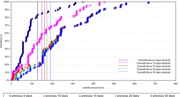
Since the work is mainly focused on landslides damages the initial conditions have a strong influence. In order to take this influence into account 30-days antecedent rainfall were considered: when the cumulate rainfall amount in the last 30 days exceeds 190 mm, we consider to be in a un-stable field according to Cancelli-Nova (1985). According to the status (stable/unstable), the warning is issued for a higher/lower return period. The assumption of using 30 days rainfall depth to determine stability/instability comes from a sensitivity analysis performed within the study. Figure 2 shows for all the damages, the antecedent cumulate rainfall versus its frequency and the stability thresholds for different time windows, according Cancelli-Nova (5, 10, 15, 20 30 days). In Fig. 2, increasing the window, which implies an increase of the stability threshold, the number of events that are influenced by the antecedent rainfall increases.
Results of pluviometric threshold estimation are shown in Table 1, where the rainfall threshold return periods obtained in this study are also compared with the ones determined in Barbero et al. (2004). The return periods determined in the present study are lower then the others. This is partially explained by the differences between the two environments analysed: Liguria region has a different morphology char-acterised by a higher urbanization, in this case even lower rainfall can be responsible for serious land effect.
Table 1. Rainfall return period threshold.
T (years) Liguria region T (years) Piedmont region Unstable field Stable field Unstable field Stable field Low risk 1.5 4 2 5 High risk 4 10 5 20
3 Comparison between two methodologies
The national warning procedure based on pluviometric thresholds is compared here with the regional hydrologically based one, which is operationally used at the Ligurian CF for the case study, from September 2003 to September 2004. For the entire period, 31 potentially critic events were analysed.
3.1 National pluviometric based warning procedure
According to the nationwide warning procedure, a warn-ing must be issued any time the forecast rainfall exceeds the pluviometric threshold determined through a back anal-ysis (Table 1). In doing this, it is necessary to compare
consistent time-spatial variables. The forecasted rainfall
in 3 h-100 km2 is modified using a Areal Reduction Factor
(Heredia-Calderon, 1997) and then compared with the local 3-hours pluviometric threshold.
3.2 Regional hydrologically based warning procedure
The warning procedure operationally used at the Ligurian CF is based on a meteo-hydrologic real time forecasting chain
(Arena et al., 2003). The meteorological forecast is
ob-tained from different tools. The main contribution to the fore-casters’ activity comes from the combined use of ECMWF Global Circulation Model and Limited Area Model BOLAM (Buzzi and Malguzzi, 1997). BOLAM is run twice a day us-ing initial and boundary conditions derived every 6 h from ECMWF initialized both at 00:00 UTC and at 12:00 UTC. Each run is performed at two different resolutions: 21 km and 6,5 km, the latter being self nested every 90 min in the 21 km run. The forecasted rainfall field is then used to drive the DRiFt (Giannoni et al., 2000) model in a probabilistic framework, performing multiple runs, not only a determin-istic run. DRiFt is a semi-distributed rainfall runoff model based on a morphologic approach, developed to be properly applied to the Liguria region.
Results of the comparison among the two procedures are described in Table 2. In the study, 31 potentially critic events were analysed. 16 times out of 31, Liguria region, based on the result of the hydrologic forecasting chain, issued a warning to the population. No false alerts were issued and no missing alerts occurred in the study period. In 6 cases the warning was for high risk. If the pluviometric threshold procedure would have been applied only 5 warnings would have been issued and in none of the cases high risk would have been forecasted.
A. Cavallo and F. Giannoni: Natural risk warning: comparison of two methodologies 337
Cumulated frequency of observed rainfall - all damages
0% 10% 20% 30% 40% 50% 60% 70% 80% 90% 100% 0 100 200 300 400 500 600 700 800 rainfall amount [mm] fr equenc y [ -]
previous 5 days previous 10 days previous 15 days previous 20 days previous 30 days
Cancelli-Nova 5 days treshold Cancelli-Nova 10 days treshold Cancelli-Nova 15 days treshold Cancelli-Nova 20 days treshold Cancelli-Nova 30 days treshold
Fig. 2. Sensitivity analysis of the antecedent precipitation.
Table 2. Comparison among the two procedures.
Data Present Operational Chain Proposed Operational Chain (hydrologic treshold based) (pluviometric treshold based)
Area A Area B Area C Area D Area E Area A Area B Area C Area D Area E
18/10/2003 – – – – – – – – – – 19/10/2003 – – – – – – – – – – 30/10/2003 1 1 1 1 1 – – – – – 31/10/2003 2 2 2 2 2 1 1 1 1 1 01/11/2003 2 2 2 2 2 – – – – – 22/11/2003 – – – – – – – – – – 23/11/2003 1 1 1 1 1 1 – – – – 24/11/2003 1 1 1 1 1 – 1 – 1 1 26/11/2003 1 1 1 1 1 1 – 1 – – 27/11/2003 1 1 1 1 1 – – – – – 29/11/2003 – – – – – – – – – – 30/11/2003 2 2 2 2 2 1 1 1 1 1 01/12/2003 2 2 1 2 2 – – – – – 02/12/2003 2 2 1 2 2 – – – – – 03/12/2003 2 2 1 2 2 – – – – – 04/12/2003 – – – – – – – – – – 26/12/2003 – – – – – – – – – – 27/12/2003 – – – – – – – – – – 28/12/2003 – – – – – – – – – – 31/12/2003 – – – – – – – – – – 17/02/2004 – – – – – – – – – – 20/02/2004 – – – – – – – – – – 21/02/2004 1 – – – – – – – – – 06/03/2004 – – – – – – – – – – 09/03/2004 – – – – – – – – – – 10/03/2004 – – – – – – – – – – 16/04/2004 – – – – – – – – – – 27/04/2004 1 – – – – – – – – – 28/04/2004 1 1 – – – – – – – – 29/04/2004 1 1 – – – – – – – -03/08/2004 1 – – – – – – – – –
338 A. Cavallo and F. Giannoni: Natural risk warning: comparison of two methodologies
4 Conclusions
The performed work, suggests that the rainfall return period are different in different morphologies. Moreover it is ex-tremely important to perform a specific study for each envi-ronment where it has to be applied. In the case of Liguria region return periods estimated through a back-analysis are lower then the ones defined by Piedmont region (see Table 1). Moreover from the comparison among the two warning pro-cedures emerges that 10 warnings would have been missed. Once deeper investigations will be performed, the pluviomet-ric warning procedure could be efficiently applied in parallel to the meteo-hydrologic forecasting chain to issues warnings.
Acknowledgements. This work has been partially supported by the
Interreg IIIB, Meddoc Amphore Project. Edited by: L. Ferraris
Reviewed by: anonymous referees
References
Arena, N., Cavallo A., Giannoni F., and Turato B.: A operational real time flood forecasting chain, Geophys. Res. Abstr., EAE 03 A10507, EGS-AGU-EUG Assembly, ISSN 1029-7006, 2003. AVI: avi.gndci.pg.cnr.it.
Barbero, S., Rabbuffetti, D., and Zaccagnino, M.: Una metodolo-gia per la definizione delle soglie pluviometriche a supporto dell’emissione dell’allertamento, 29◦ Convegno di Idraulica e Costruzioni Idrauliche, Trento, 2004.
Boni, G.: A physically based regional rainfall frequency analysis: application to a coastal region in Northern Italy, Proc. of EGS Plinius Conference on Mediterranean Storms, Maratea, Italy, 365–376, 1999.
Buzzi, A. and Malguzzi, P.: The BOLAM3 model: recent improve-ments and results, MAP Newsletter, 7, 98–99, 1997.
Cancelli, A. and Nova, R.: Landslides in soil debris cover triggered by rainstorms in Valtellina (central Alps-Italy), Dep. of Structural Engineering Technical University of Milano, Italy, 1995. Executive Order: Direttiva del presidente del consiglio dei ministri
27 febbraio 2004, Indirizzi operativi per la gestione organizzativa e funzionale del sistema di allertamento nazionale e regionale per il rischio idrogeologico ed idraulico ai fini di protezione civile, Supplemento ordinario n. 39 della GU 59 del 11.03.04. De Michele, C. and Rosso, R.: La valutazione delle piene nell’Italia
Nord-Occidentale: bacino padano e Liguria tirrenica, CNR-GNDCI, 1999.
Giannoni, F., Roth, G., and Rudari, R.: A Semi – Distributed Rain-fall – Runoff Model Based on a Geomorphologic Approach, Physics and Chemistry of the Earth, 25/7–8, 665–671, 2000. Heredia-Calderon, E. A.: Distribuzione spazio temporale delle
pre-cipitazioni intense e coefficienti di ragguaglio areale per eventi rari, Genova, 1997.
Siccardi, F.: Rainstorm Hazard and Related Disasters in the North-West Mediterranean Region, Remote Sensing Reviews, 14, 5–21, 1996.