Collaborative Micro Aerial Vehicle Exploration of Outdoor
Environments
MASSAC
by
OFDavid Pitman
OC
S.B., Massachusetts Institute of Technology (2006)
LI
Submitted to the Department of Electrical Engineering and Computer Science
in partial fulfillment of the requirements for the Degree of
Master of Engineering in Electrical Engineering and Computer Science
A
at the Massachusetts Institute of Technology
OF
February 2010
@2010
Massachusetts Institute of Technology
All rights reserved.
LI
HIUSETS INS TITUTE TECHNOLOGY
T
2 6 2010
BRARI ES
RCHNVES
A uthor ...
Department of Electrical Engineering and Computer Science
February 10, 2010
C
ertified b y ...
... / ...
. . . .. .. .
Associate Professor of Aeronautics and Astronautics
Thesis Supervisor
A ccepted by ...
...
' O 3
Arthur C. Smith
Professor of Electrical Engineering
Chairman, Department Committee on Graduate Theses
TECHNOLOGY
RA
201
IRARIES
Contents
1 Introduction
1.1 Micro Aerial Vehicles ... 1.1.1 MAV Operators ... 1.1.2 MAV GCSs ... 1.2 Mobile Devices ... 1.3 Problem Statement ... 1.4 Research Objectives ... 1.5 Thesis Organization . . . . . 2 Background 2.1 Human-Robot Interaction . . . . 2.1.1 Human Supervisory Control . . . . 2.1.2 Human-Robot Interaction Roles . . . 2.1.3 Urban Search and Rescue (USAR) 2.2 Research Relevant to MAV Interaction . . . . 2.3 Research in Hand-held Devices . . . .
2.4 Summary . . . .
3 Interface Design
3.1 Introduction . . . ... 3.2 Cognitive Task Analysis . . . . 3.3 MAV Interface Requirements . . . ....
3.3.1 Desired MAV Roles & Requirements .
3.3.2 Interface Requirements . . . .
3.4 MAV-VUE Displays and Interaction . . . . . 3.4.1 Navigation Mode: Map & Waypoints . 3.4.2
3.4.3 3.4.4
Mini Vertical Altitude and Velocity Indicator Health & Status Monitoring . . . . . . ..
Nudge Control Flight Mode . . . . . . ..
19 . . . 21 . . . . . . . . . . . 2 2 29 . . . . 29 . . . . 29 . . . . 31 . . . . 32 . . . . 33 . . . . 36 . . . . 37 39 . . . . 39 . . . . 39 . . . . 40 . . . . 40 . . . . 42 . . . . 45 . . . . 45 . . . . 47 . . . . 48 . . . . 48 . . . . . . . . . . . .
3.5 Design Principles... .. . . . . . . . 50
3.5.1 Direct Manipulation . . . . 50
3.5.2 Multimodal Interaction.... . . . . . . . 50
3.5.3 Order Reduction . . . . 51
3.5.4 Perceived First Order Control . . . . 53
3.6 Architecture... . . . . . . . . . 59 3.7 Sum m ary . . . . 60 4 Usability Evaluation 63 4.1 Study Objectives . . . . 63 4.2 Research Questions.. . . . . . . . . 63 4.3 Participants... . . . . . . . . . . . . 64 4.4 Test Bed . . . . . . . . . . . . . . . . 64 4.4.1 Apparatus . . . . 64 4.5 Experiment Metrics . . . . 66
4.5.1 Task Performance Time... . . . . . . 66
4.5.2 Spatial Reasoning . . . . 66
4.5.3 Additional Mission Performance Metrics . . . . 66
4.5.4 Qualitative Metrics . . . . 67
4.6 Procedure... . . . . 67
4.7 Data Collection... . . . . . . . 69
4.8 Sum m ary . . . . 69
5 Results and Discussion 71 5.1 Introduction . . . . 71
5.2 Score Task Performance Time... . . . . . . . . 71
5.3 Eye Chart Identification . . . . 72
5.4 Person of Interest Identification . . . . 74
5.5 Nudge Control Analysis . . . . 75
5.5.1 Webcam Imagery and Frame Rate . . . . 76
5.6 Participants' Navigation Strategies... . . . . . . . . 76
5.6.1 Participant A.. . . . . . . . 77 5.6.2 Participant B . . . . 78 5.6.3 Participant C . . . . 79 5.7 Subjective Responses . . . . . . . . . . . . 80 5.7.1 Navigation Mode... . . . . . . . .. 80 5.7.2 Nudge Control . . . . 80
5.8 Experiment Observations . . . . 82 5.9 Sum m ary . . . . 83
6 Conclusions 85
6.1 Research Objectives and Findings. . . . . 86 6.2 Future W ork . . . . 87
A Cognitive Task Analysis Interview Questions 89
B Demographic Survey and Statistics 91
C Configuration of the Micro Aerial Vehicle (MAV) 95
D Usability Survey 97
E Consent to Participate Form 103
F Maps 109
G Snellen Eye Chart 111
H Person of Interest Used and Identification Sheet 113
I Debriefing Interview Questions 117
J Scored Task Descriptive Statistics 119
List of Figures
1-1 Comparison of overhead satellite imagery of a building with Three Dimensional (3D) model
of the sam e building. . . . . 20
1-2 A Honeywell RQ-16 T-Hawk in flight, courtesy of U.S. Navy. . . . . 21
1-3 Examples of commercial MAVs available on the market. . . . . 22
1-4 Examples of software interfaces for commercial MAVs... . . . . . . . . . 23
1-5 Examples of MAV Ground Control Stations. . . . . 24
1-6 Video goggles for AeroVironment's Ground Control Station (GCS), photo by author. . . . 25
1-7 An Army operator controlling a RQ-16 with a stylus, courtesy of U.S. Army. . . . . 25
2-1 General Human Supervisory Control, adapted from Sheridan [7]. . . . . 29
2-2 Hierarchical Control Loops for a Single MAV performing an Intelligence, Surveillance & Reconnaissance (ISR) mission, adapted from Cummings et al. [11] . . . .... . ... 30
2-3 MAV control interfaces created by Durlach et al. [29] . . . . 35
3-1 The map display and general interface of MAV-VUE. . . . . 45
3-2 The inset webcam view within the map display. . . . . 46
3-3 Details of the MAV-VUE map display. . . . . 46
3-4 Waypoint states in the map display . . . . 47
3-5 The Mini-VAVI shown on the map display. . . . . 47
3-6 Health and Status monitoring display in MAV-VUE. . . . . 48
3-7 Overview of Nudge Control interface. . . . . 49
3-8 Details of Nudge Control directional interface. . . . . 49
3-9 1't order feedback control with a pulse input. . . . . 51
3-10 Interface feedback as a result of the operator performing a natural tilt gesture with the device... ... 53
3-12 Using a swipe touch gesture to move the MAV left . . . . 54
3-11 Diagram of Perceived First Order Control. Delays and lags are represented by r, gains represented by k.. . . . . . . . . 55
3-13 Discrete step function initially used for gain, k. . . . . 56
3-15 Gestures to change the z coordinate (altitude) of the MAV . . . . 58
3-16 Using the VAVI to change the z coordinate of the MAV. . . . ... 58
3-17 Swiping a finger across the screen causes the device to rotate (yaw) right or left. . . . . . 59
3-18 Communication architecture between Micro Aerial Vehicle Exploration of an Unknown Environment (MAV-VUE), MAVServer, and MAV. . . . ... 60
4-1 Modified Ascending Technologies Hummingbird AutoPilot used in study . . . . 65
4-2 Annotated version of the map used in the study showing the layout of the environment. . 68 5-1 Box plot of participants' times to complete the scored task. . . . . 72
5-2 Images which participants saw while trying to read a line of the eye chart. . . . . 73
5-3 Examples of blurred imagery seen by participants while trying to identify the eye chart. . 73 5-4 Examples of imagery seen by participants while finding and identifying the POI. . . . . . 74
5-5 Participant A's flight path. . . . . 77
5-6 Participant B's flight path. . . . . . . . . 78
5-7 Participant C's flight path. . . . . 79
5-8 Intended and observed interaction to issue a Nudge Control yaw command. . . . . 81
5-9 Resting poses observed while participants used the interface, courtesy of Nadya Peek. . . 82
F-1 The map displayed on the subject's iPod... . . . . . . . . . . . . 109
F-2 Supplementary map given to subject for their scored task... . . . . . . . 110
G-1 Example of the standard Snellen eye chart used in the study, by Jeff Dahl. Licensed under the Creative Commons Attribution-Share Alike 3.0 Unported License.. . . . . . . 112
H-1 Person of Interest (POI) used in the scored task of the usability study. . . . 114
List of Tables
2.1 Sheridan and Verplank Levels of Automation [8] . . . . 30
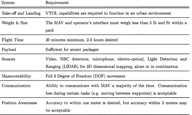
2.2 Scholtz's Human-Robot Interaction (HRI) roles, with Goodrich and Schulz's additions, adapted from [12, 13] . . . . 31 3.1 Potential roles for an operator and a MAV collaboratively exploring an outdoor environment. 40 3.2 Potential MAV outdoor ISR missions . . . . 41 3.3 System requirements for a MAV performing an outdoor ISR mission. . . . . 42
3.4 Functional requirements for a HRI interface to support collaborative exploration of an unknown environment. . . . . 43
3.5 Information requirements to support collaborative exploration of an unknown environment. 44
B.1 B.2 B.3 B.4 D.1 D.2 D.3
Responses for self-assessed sleep quality . . . . Responses for self-assessed video game experience . . . . Responses for self-assessed Remote Control (RC) vehicle experience . . . Responses for self-assessed comfort with Google MapsTM , Google EarthTM Responses for self-assessed confidence in actions during scored task. . . . Responses for self-assessed performance during scored task. . . . . Responses for self-assessed understanding of interface. . . . .
and iPhone
101 101 101
Performance Descriptive Statistics. . . . 119 Times Descriptive Statistics . . . 120
J.3 Descriptive statistics of Nudge Control commands performed by participants during the
Collaborative Micro Aerial Vehicle Exploration of Outdoor Environments by
David Pitman Submitted to the
Department of Electrical Engineering and Computer Science February 10, 2010
In partial fulfillment of the requirements for the Degree of Master of Engineering in Electrical Engineering and Computer Science
Abstract
Field personnel, such as soldiers, police SWAT teams, and first responders, face challenging, dangerous environments, often with little advance knowledge or information about their surroundings. Currently, this Intelligence, Surveillance & Reconnaissance (ISR) information is provided by satellite imagery and prior or second-hand experiences. Although satellite imagery is currently the preferred method for gaining Situational Awareness (SA) about an outdoor environment, it has many shortcomings. Unclassified satellite imagery maps available to these field personnel are flat images, with no elevation information and fixed points of view. These maps are often outdated, and, due to shadows and shading, give false impressions of elevations and details of the environment. Critical features of buildings, such as doorways and windows are hidden from view. Combined, these flaws often give field personnel a false mental model of their environment.
Given the need of these personnel to simultaneously perform a primary task, such as finding a Person of Interest (POI), as well as explore the environment, an autonomous robot would allow these groups to better perform ISR and improve their SA in real-time. Recent efforts have led to the creation of Micro Aerial Vehicles (MAVs), a class of Unmanned Aerial Vehicle (UAV), which are small and have autonomous capabilities. At most a few feet in size, a MAV can hover in place, perform Vertical Take-Off and Landing, and easily rotate with a small sensor payload. The compact size of these vehicles and their maneuvering capabilities make them well-suited for performing highly localized ISR missions with MAV operator working within the same environment as the vehicle. Unfortunately, existing interfaces for MAVs ignore the needs of field operators, requiring bulky equipment and the operator's full attention.
To be able to collaboratively explore an environment with a MAV, an operator needs a mobile interface which can support the need for divided attention. To address this need, a Cognitive Task Analysis (CTA) was performed with the intended users of the interface to assess their needs, as well as the roles and functions a MAV could provide. Based on this CTA, a set of functional and information requirements were created which outlined the necessities of an interface for exploring an environment with a MAV. Based on these requirements, the Micro Aerial Vehicle Exploration of an Unknown Environment
(MAV-VUE) interface was designed and implemented. Using MAV-VUE, operators can navigate the MAV using
waypoints, which requires little attention. When the operator needs more fine-grained control over the MAV's location and orientation, in order to obtain imagery or learn more about an environment, he or she can use the Nudge Control mode. Nudge Control uses Perceived First Order (PFO) control to allow an operator effectively "fly" a MAV with no risk to the vehicle. PFO control, which was invented for
MAV-VUE, utilizes a 0th order feedback control loop to fly the MAV, while presenting 1st order controls to the operator.
A usability study was conducted to evaluate MAV-VUE. Participants were shown a demonstration
this task, participants were given search and identify objectives, MAV-VUE installed on an iPhone@ and an actual MAV to explore a GPS-simulated urban environment. Participants performed well at the task, with thirteen of fourteen successfully performing their objectives with no crashes or collisions. Several statistically significant correlations were found between participants' performance and their usage of the interface. Operators who were more patient and had higher scores on a spatial orientation pretest tended to have more precise MAV control. Future design and implementation recommendations learned from this study are discussed.
Thesis Supervisor: Mary L. Cummings
Acknowledgements
The success of this thesis is only in part to due my efforts, with many other individuals providing help, their time, advice and friendship throughout its course.
First, I would like to thank Missy Cummings, my research advisor at MIT. Your hard work ethic, unrelenting attention to details, and ingenuity have been a constant source of inspiration for me. I have always appreciated the time you take to sit down and answer my questions or explain concepts. HAL has been a great place to be, and the question you are trying to answer will always be of interest me.
Research at MIT is not true research without UROPs. Thank you to Paul Quimby for always finding a solution to seemingly impossible problems, your hardwork and persistence will serve you well, and to Carine Abi Akar, for calmly handling our participants and doing whatever needed to be done.
Often while collaborating with the ACL, I found myself with a question or quad rotor in need of repair. I would like to thank Buddy for his patient assistance and hard efforts to help us, as well as the rest of the ACL for making themselves available to answer questions.
Gracious thanks are necessary to Thomas Villaren, who helped me to first develop MAV-VUE, and to Pierre Maere, who endured long hours of soldering and quad rotor duty, always with a smile.
Special thanks go to Cam, for acting as an endless source of Course 16 information. Also, thank you to Jeff for all the great discussions about new ideas.
My friends in HAL, Anna, Andrew, Christin, Dan, Farsan, Jackie, and many others, thank you for
all the conversation, fun, and happy hours at the R&D Pub.
I would like to thank my parents, who have always served as my best role models. Thank you for the good cooking and skiing, the good advice and understanding when I was too busy too talk. Thank you to my sister, Lisa, for showing me what being truly dedicated to your passions mean and always having a good joke on hand.
Lots of thanks to the Slugs and my friends at the Media Lab.
Emily, a few sentences can in no way describe how you have helped me over the years, so I will not try. Instead, know all of the appreciation I have and the fact that every day is more fun because you are around.
Nomenclature
2D T w o D im ensional...54 3D T hree D im ensional... ... 7 A Ol
A rea of Interest...22 ch channel...64 CT Conventional Touch...48CTA Cognitive Task A nalysis ... 27
DARPA Defense Advanced Research Projects Agency...21
DoD United States Department of Defense ... 19
DOF Degree of reedom dpi dots per inch ... 26
fps fram es per second ... 65
ft fo ot ... ... ... ... 56
FO V F ield of V iew ... 33
G B G igabytes...64
G H z G igahertz ... 64
GCS G round Control Station...21
GPS Global Positioning System ... 22
G U I G raphical U ser Interface...32
HCI Human-Computer Interaction...32
HRI Human-Robot Interaction... 26
HSC Human Supervisory Control...29
H z H ertz ... . 57
IM U Inertial M easurem ent Unit...48
in in ch es ... 2 1
IP Internet P rotocol ... 60
ISR Intelligence, Surveillance & Reconnaissance ... 19
JSO N JavaScript Object Notation ... 60
km /s kilom eters/second ... 35
lb p ou n d ... 2 1 LIDAR Light Detection and Ranging LO A Level of A utom ation .. ... ... 29
m A m illi-am peres ... 64
M AUI M inimal Attention User Interface ... 36
M AV M icro A erial Vehicle ... 20
MAV-VUE Micro Aerial Vehicle Exploration of an Unknown Environment ... 39
M b M egabits ... 64
M H z M egahertz ... 64
MOLLE Modular Lightweight Load-carrying Equipment ... 21
M RT M ental Rotation Test ... 66
M VC M odel-Viewer-Controller...59
N G N atural G esture ... 48
NBC Nuclear, Biological and Chemical NFZ No Fly Zone ... 56
0 0 1 O bject of Interest...35
PDA Personal Digital Assistant... 26
PFO Perceived First O rder...53
P O I Person of Interest ... 20
PTSOT Perspective Taking and Spatial Orientation Test ... 66
px pixel... ... . 45
RAVEN Real-time indoor Autonomous Vehicle test ENvironment ... 64
RC R em ote Control... 64
SA Situational A wareness...20
sd standard deviation ... 64 16
sec second ... 36
SLAM Simultaneous Localization and Mapping...56
SW AT Special W eapons and Tactics...39
TCP Transmission Control Protocol...60
UAS Unm anned Aerial System ... 21
UAV Unm anned Aerial Vehicle...19
UGV Unmanned Ground Vehicle...32
UD P User D atagram Protocol...65
U
I
U ser Interaction ... 45UV U nm anned Vehicle...26
U SB U niversal Serial B us ... 65
USAR Unmanned Search and Rescue ... 20
VAVI Vertical Altitude and Velocity Indicator...47
VTOL Vertical Take-Off and Landing ... 21
WYSIWYG What-You-See-Is-What-You-Get ... 34
Chapter 1
Introduction
Obtaining Intelligence, Surveillance & Reconnaissance (ISR) information in real-time is a top priority for the United States Department of Defense (DoD), as well as other first responder and homeland defense agencies. Satellite imagery, Unmanned Aerial Vehicles (UAVs) and other advances have revolutionized how the military maintains situational awareness about a battlefield. These advances have allowed the military to obtain much more information while simultaneously removing the need for soldiers to perform risky in situ ISR missions. However, many of these technologies only provide a larger overview of a situation at periodic points in time. For the warfighter on the ground, means of obtaining real-time intelligence and information about their environment have lagged behind the sophisticated techniques used by battlefield commanders. Recently, however, advances in autonomous unmanned vehicles and mobile computing have created new opportunities to outfit a soldier with a personal robot capable of performing customized, detailed exploration of a local environment.
Soldiers entering a dense city have a poor understanding of the topography and urban environment they will encounter. Currently the best tool available to help soldiers understand a city environment is unclassified satellite imagery. While satellite imagery provides an understanding of the urban layout of a city, it lacks information which is critical to an understanding of the environment at a ground level.
A solider may need to enter a building, jump a fence without knowing what is on the other side, or
determine where potential secondary entries and exits are located in a building. Overshadowing all of these potential actions is the need to have a good understanding of the immediate vicinity and tactical advantages such as low walls, grassy openings, clear sight lines, and streets or alleys which dead-end. None of these questions can easily be answered from a satellite map alone, and often soldiers simply rely on past or second hand experience with the environment.
Figure 1-1: Comparison of overhead satellite imagery of a building with 3D model of the same building.
A flat image, these maps give no elevation information, and often, due to shadows and shading, give false
impressions of elevation. For example, while it can be safely assumed that roads approximate a level plane, the rest of an urban environment is often closer to a series of blocks of varying heights or depths with shadows cast by adjacent buildings. Building entrances and exits are hidden due to the birds-eye view of a satellite image, with little to no information about a building's exterior. An example of this problem is shown in 1-1. This imagery is often outdated or relevant only to the season in which the image was taken. Combined, these flaws often give soldiers a false mental model of their environment. Many of these flaws could be addressed by having personnel on the ground use a robot to explore and map their environment. Given the need of these personnel to simultaneously perform a primary task such as finding a Person of Interest (POI), an autonomous robot would allow these groups to better perform ISR and improve their Situational Awareness (SA) in real-time. However, performing an ISR mission aided by an autonomous vehicle will require an interface which allows the user to easily transition between high-level control of the robot (e.g. moving via waypoints) and a low-level, fine-grained control to align the robot for obtaining the best view.
Recent advances in several fields have led to a new type of unmanned autonomous vehicles known as Micro Aerial Vehicles (MAVs). Given their compact size, low cost, and flight capabilities, MAVs are primarily marketed and designed for ISR-type missions. In a conventional ISR mission, people interviewed for this effort envisioned that soldiers and law-enforcement personnel would use a MAV to improve their SA of an urban environment or building. MAVs are also ideal for Unmanned Search and Rescue (USAR) missions, where they can easily traverse rubble and other obstacles which would normally prove challenging for ground-based USAR robots. Finally, MAVs can be used in a variety of
civilian applications, such as structural inspections or environmental/farming surveys.
1.1
Micro Aerial Vehicles
MAVs were first investigated in a Defense Advanced Research Projects Agency (DARPA) program in the late 1990s which examined the feasibility of creating small aircraft less than 6 inches (in) diameter [1].
Although the study was successful and several MAVs were subsequently created according to the original DARPA specifications (i.e., TU's Delfy [21, AeroEnvironment MicroBat, etc), the commercial sector has largely pursued MAV helicopters. Simultaneously, the Army has pursued their own class of MAVs, known as Class I Unmanned Aerial System (UAS), which are larger and designated for platoon-level support [3]. Class I UASs are required to weigh less than 51 pounds (lbs) (including the Ground Control Station (GCS)) and should fit into two custom Modular Lightweight Load-carrying Equipment (MOLLE) containers, which are approximately the size of a large backpack. Currently, the only deployed Class I system is the Honeywell RQ-16 "T-Hawk," seen in Fig. 1-2.
For the purposes of this thesis, the term MAV will be used to refer to the commercial sector MAVs that are available or in development. These helicopters may have two, four, or six rotors, are typically less than two feet across, and can carry payloads of up to a kilogram. Several off-the-shelf MAVs are
available from a variety of companies, and two such examples are shown in Fig. 1-3.
Figure 1-2: A Honeywell RQ-16 T-Hawk in flight, courtesy of U.S. Navy.
These MAVs all share a common set of features which are critical to their proposed use case for ISR missions. First and foremost, these vehicles are capable of Vertical Take-Off and Landing (VTOL), which
(a) Ascending Technologies Hummingbird (b) DraganFlyerm X6, used with permission from DraganFly Innovations, Inc. Figure 1-3: Examples of commercial MAVs available on the market.
allows them to be launched and recovered in confined spaces or urban environments which may not have
the physical space to allow for a traditional takeoff/landing. Complementing their VTOL capability, these MAVs are able to precisely hover and move to a fixed point in space. This allows them to easily survey from a fixed vantage point, without the need to make repeated passes of an Area of Interest (AOI), a capability referred to as "perch and stare". To support these capabilities, MAVs range from semi- to fully-autonomous. Even the most basic MAVs have complex flight dynamics which require a low level of automation to maintain vehicle stability in-flight. More advanced MAVs are fully autonomous and capable of flying a route of Global Positioning System (GPS) waypoints with no human intervention [4].
1.1.1 MAV Operators
Given their short flight time, MAVs are operated by field personnel located in the vicinity of the MAV. These field personnel may be emergency first responders, police, specialists (e.g., building inspectors or bomb technicians) or, most commonly, dismounted, forward-deployed soldiers. All of these groups operate in hazardous environments which may contain hostile, armed people, unstable structures, or environmental disasters. Although these personnel may operate a MAV, it is never their primary task. Rescue personnel are concerned with finding and saving victims, and soldiers may be on a patrol or searching for POIs. Operating the MAV is not an independent goal of these personnel. Instead, the MAV provides a means of effectively achieving their primary objectives. However, this additional aid comes at the cost of dividing the operator's attention and possibly diminishing his or her SA. The problem of divided attention currently makes MAVs effectively unusable by personnel who already have demanding tasks they cannot afford to ignore.
Wapoir t Lst r Eds.. Mdklih _A A f r 1 YAW C. Do7-alfmen DstandelR 0 P Ar JPlacemark Lis
(a) Ascending Technologies AutoPilot Software, used with permission of Ascending Technolo-gies, GmbH.
(b) DraganFlyer's ground control software, used with permission of DraganFly Innovations, Inc.
Figure 1-4: Examples of software interfaces for commercial MAVs.
1.1.2
MAV GCSs
Currently, MAVs are controlled via computer interfaces, as seen in Fig. 1-4. Some MAVs are controlled with more specialized GCSs. Typically a ruggedized laptop display, GCSs may incorporate specialized controls such as miniature joysticks or pen styli (Fig. 1-5) and range from a hand-held device to a large briefcase in size. Many of these GCSs take several minutes to assemble and establish a connection with the MAV every time they are used. In addition, the bulk of a GCS adds significant weight to the pack of an already fully-loaded soldier. Some interfaces, such as the AeroVironment's MAV GCS (Fig. 1-6) and DraganFlyer, offer goggles which allow the operator to view a video feed from the MAV. As seen in Figure 1-7, all interfaces require an operator to use both hands to interact with the MAV.
(a) Honeywell's RQ-16 Ground Control Sta-tion, which is similar to a rudimentary tablet PC, courtesy of Honeywell.
GPS
(b) DraganFly's X6 manual flight controller, used with permission of
DraganFly Innovations, Inc.
Figure 1-5: Examples of MAV Ground Control Stations.
A majority of interfaces and GCSs require the full attention of the operator. These systems require
extensive training before an operator can safely and effectively operate the MAV. GCSs which allow the operator to manually position and orient the MAV rely on a classical 1s* order feedback control loop,
which allows operators to directly control the thrust, pitch, and roll/yaw of the MAV. This complex
Pitch Tnm
Rog & Pith
feedback loop demands full attention of the operator.
All current reconnaissance MAV interfaces are rooted
in the constrained case that the operator's primary task is to operate the MAV, which includes both flying the vehicle and searching images from the vehicle concerning targets of interest. These design choices appear to be the extension of larger UAV ground stations (e.g, the Predator GCS). Other design choices have confusing rationale when con-sidering the needs and divided attention of a field operator in a hostile environment. For example, video goggles (Fig.
1-6) blind operators to their surroundings, depriving them
Figure 1-6: Video goggles for AeroViron-of critical perceptual cues, both foveal and peripheral. As ment's GCS, photo by author. a consequence, current GCSs and interfaces have a
num-ber of design decisions which preclude them from being used effectively by field operators, who almost universally have other, more urgent primary tasks to accomplish.
While these types of interfaces have been successfully used in many conventional UAV interfaces, they ignore the unique capabilities afforded by a MAV. Given their short flight time, MAVs on ISR missions are best suited to act in collaboration with personnel on the ground in the same area the MAV is surveying. From a human-centered view, MAVs performing local ISR missions could report directly to personnel in the field, such as soldiers, police, or first-responders, and even collaborate together to discover an unexplored environment. Creating a high-level interface on a truly mobile device will mitigate many of the existing flaws in present-day MAV inter-faces. This interface must appropriately balance the need to Figure 1-7: An Army operator controlling a support intermittent interaction from a user and having safe,
RQ-16 with a stylus, courtesy of intuitive flight controls when the user needs fine-grained con-U.S. Army.
trol over the MAV's position and orientation (such as peering in a window during an ISR mission). Additionally, existing interfaces ignore the context of the situation in which they are used. With soldiers already carrying packs weighing 90 lb or more [5], the additional weight and size of any new equipment is an extreme burden. Likewise, in these dangerous environments, interaction methods which introduce more specialized equipment, such as a stylus or video goggles, make the equipment more prone to failure or being lost. Combined, these considerations clearly necessitate
a compact, simple device if soldiers and other operators are realistically expected to use a MAV in the field.
1.2
Mobile Devices
Like MAVs, handheld mobile devices have recently emerged as a smaller counterpart to traditional lap-top/desktop computers. Although the concept has existed since the mid-nineties in the form of Personal Digital Assistants (PDAs), these devices previously had a minimum amount of computing power with poor displays, and were viewed as a digital extension of a notepad or contact list. The PDA industry lost ground after 2000, as mobile phones became more powerful and incorporated new features such as cameras and basic internet access. Only in the last few years have mobile devices finally achieved a state where they are able to run powerful applications and support meaningful interactions without the tra-ditional keyboard and mouse. Known as smart phones, several platforms have emerged for these mobile devices, most notably the Apple iPhone@ and Google AndroidTM. Both of these platforms are based on a touch-screen, internet-enabled device which is aware of its location and can sense the device's tilt and orientation through on-board sensors. Although not specifically stated, these devices also have screen resolutions of 150-225 dots per inch (dpi), which allows them to display detailed imagery in a compact physical format compared to normal computer displays. Given their portability and user-centered focus, handheld devices provide a possible platform for a new type of MAV GCS.
1.3
Problem Statement
As robots become more integrated into ISR missions, effective interaction between humans and robotics will become more critical to the success of the mission and the safety of both the operator and robot. Previously, Human-Robot Interaction (HRI) has focused largely on working with robots through teleop-eration, or as independent agents in their environment. Teleoperation interactions ignore the problem of the divided attention of the field personnel, the importance of environment, and the issue that their primary goal is to perform ISR, not to drive a Unmanned Vehicle (UV). For successful collaborative exploration of an unknown environment, an interface must first be developed which allows a user to work with an autonomous robot operating within the same environment. This interface should not restrict the operator from their primary task; it must be a truly mobile device and not require the operator's continual attention. This necessitates an interface that can allow an operator to easily control a robot at a high-level supervisory mode of interaction for general commands, as well as a fine-grained, lower level of control when more nuanced actions are required. A mobile device which successfully allows operators to supervise and occasionally directly operate a robot will dramatically change the way robots are used in high-risk environments.
1.4 Research Objectives
In order to address the problem statement, the primary goal of this research is to develop a mobile interface for interacting with an autonomous MAV. This goal is addressed through the following research objectives:
" Objective 1. Determine the function and information requirements for a MAV interface.
To achieve this objective, a Cognitive Task Analysis (CTA) was performed with personnel likely to benefit from using a MAV to explore an unknown environment. These personnel were interviewed to identify needs and usage scenarios, as described in Chapter 3. Current practices for operating
MAVs and designing relevant mobile interfaces were researched in support of this objective.
" Objective 2. Develop a mobile interface which allows an operator to explore an unknown environment with a MAV. Based upon the research performed for Objective 1, a mobile interface
for a MAV was designed and implemented (Chapter 3).
" Objective 3. Evaluate the usability of the interface. An experiment with human participants
was conducted (Chapters 4 and 5) to determine how well the interface supported an operator in exploring an unknown environment.
1.5
Thesis Organization
This thesis is organized into the following chapters:
" Chapter 1, Introduction, provides an overview of the research, the motivations, and the objectives
of this thesis.
* Chapter 2, Background, examines related work in HRI and hand-held device communities.
" Chapter 3, Interface Design, describes the rationale and formulation of the application designed to
control a MAV in an outdoor environment.
" Chapter 4, Usability Evaluation, describes the design of the usability study conducted involving the
interface.
" Chapter 5, Results, analyzes data gathered from the Usability Evaluation and discusses important
relationships across the data.
" Chapter 6, Conclusions and Future Work, compares the results obtained with the hypotheses
postu-lated, discusses how well the research objectives were met, and proposes directions in which further research could be conducted.
Chapter 2
Background
2.1
Human-Robot Interaction
2.1.1 Human Supervisory Control
MAV interfaces embody a form of Human Supervisory Control (HSC), which as depicted in Fig. 2-1, is when a human supervisor executes control of a complex system by acting through an intermediate agent, such as a computer. This interaction is performed on an intermittent basis, which may be periodic or in response to changing conditions of the system. While engaged in supervisory control, a human will develop a plan with the assistance of the agent, then instruct the agent to perform the plan. As the plan is executed, the human supervises the agent and intervenes as mistakes are made, events change, or the agent requires assistance, then learns from the experience to improve future plans [6]. In the case of controlling a MAV using HSC, an operator creates a set of waypoints for a MAV to visit, evaluates the path planned by the MAV to visit the waypoints, and then changes waypoints. The intermediate
Human Controls -10 Actuators
Operator --- Task
(supervisor) Displays Sensors
Computer
Figure 2-1: General Human Supervisory Control, adapted from Sheridan [7].
Table 2.1: Sheridan and Verplank Levels of Automation [8]
Automation Level Automation Description
1 The computer offers no assistance: human must take all decision and actions. 2 The computer offers a complete set of decision/action alternatives, or
3 narrows the selection down to a few, or
4 suggests one alternative, and
5 executes that suggestion if the human approves, or
6 allows the human a restricted time to veto before automatic execution, or
7 executes automatically, then necessarily informs humans, and
8 informs the human only if asked, or
9 informs the human only if it, the computer, decides to.
10 The computer decides everything and acts autonomously, ignoring the human.
the complexity of the system and help reduce cognitive workload. These levels can range from low, where recommendations are provided by the automated agent and the human retains complete control of decision-making, to the highest levels, where an agent may independently make decisions without informing the human. The range of LOA (Table 2.1) were originally proposed by Sheridan and Verplank
[8]. One might expect the human's cognitive workload to decrease as the level of automation increases.
However, increasing automation beyond what is needed may lead to loss of SA, complacency, and skill degradation.[9, 10] As Cummings et al. show in Fig. 2-2, HSC of a UAV relies upon a set of hierarchical control loops [11]. However, accomplishing higher level tasks, such as ISR, depends directly upon shifting some of the lower-level tasks, like piloting the vehicle and navigation, to automation. If an operator is required to manually perform the inner control loops, his attention becomes divided between the original task and lower level functions. Introducing automation into these inner control loops allows an operator to effectively execute HSC and devote most of their attention to their primary task of mission and payload management.
MAV Health & Status Monitoring
Figure 2-2: Hierarchical Control Loops for a Single MAV performing an ISR mission, adapted from
2.1.2 Human-Robot Interaction Roles
HRI is a subset of human supervisory control, which generally focuses on mediating interaction between a human and robot. In 2003, Scholtz defined various roles which a human interacting with a robot could fulfill (Table 2.2), such as Supervisor, Operator or Mechanic [12]. Although these roles have existed in the Human Supervisory Control community for some time, Scholz postulated the specific HRI needs and requirements (Table 2.2) that would be necessary for humans in these roles to perform their tasks, while still maintaining adequate SA.
Table 2.2: Scholtz's HRI roles, with Goodrich and Schulz's additions, adapted from [12, 13]
Role Description
Supervisor monitoring and controlling the situation
Operator modify internal software or models when the robot's behavior is not acceptable
Mechanic handles physical interventions and modifying the robot's hardware Peer teammates of the robot can give commands with larger goals/intentions Bystander may influence the robot's actions by their own actions, but has no direct
control
Mentor the robot is in a teaching or leadership role for the human Information Consumer the human does not control the robot, but the human uses information
coming from the robot in, for example, a reconnaissance task.
Most recently, Goodrich and Schulz performed a survey of HRI research efforts [13]. They present a case for classifying interaction as remote (where the human is physically separated or distant from the robot) and proximate (where the human is near or within the same environment as the robot). Providing this distinction allows for Goodrich and Schulz to more precisely identify which interaction techniques are best for each role. They also expand on Scholtz's roles, extending the list by including Mentor and Information Consumer (Table 2.2). Relevant to this effort, the Information Consumer is defined as a human who seeks to use information provided by an autonomous robot, such as in an ISR mission. A soldier operating a MAV will alternate between acting as a Supervisor, as he develops plans for the MAV's exploration, and Information Consumer when he is examining imagery returned by the MAV. Eventually,
highly autonomous MAVs may support the role of a field operator as a Peer.
view specific efforts and endeavors when creating a hand-held interface for controlling a small autonomous vehicle. By and large, all of the existing HRI research in the supervisor/operator/information consumer domains has tried to frame high-level HRI as Human-Computer Interaction (HCI) which as a by-product, manipulate robots operating in the real world.
2.1.3 Urban Search and Rescue (USAR)
One HRI domain that has received significant attention for human operators as Information Consumers and Supervisors has been the USAR field. The field of USAR seeks to develop robots and interfaces which allow first responders to remotely explore dangerous environments. Numerous studies have been conducted on the effectiveness of USAR interfaces (e.g., [14, 15]). Researchers have also studied USAR competitions to better understand why many of the teams failed to successfully finish the competitions
[16, 17]. While these studies concentrated on using Unmanned Ground Vehicles (UGVs) to explore the
environment, the problems in conducting unmanned USAR and MAV ISR missions are very similar.
USAR teams must navigate unfamiliar environments with little pre-existing intelligence and dynamically
build SA through the sensors available on the robot. In addition, navigation is particularly challenging in USAR due to the challenges of the terrain (e.g. rubble, low-visibility, confined spaces). Both Scholtz et al. [18] and Yanco and Drury [17] found that many teams in USAR competitions were hindered by their ability to effectively navigate their robots using interfaces which they had designed and extensively trained with in order to operate the vehicles. Operators were plagued by problems involving poor SA and fundamental usability issues, such as window occlusion and requiring operators to memorize key bindings
[17]. In all cases, the teams were not constrained in how they could design their interface, and a wide
variety of interfaces were observed, from multiple displays to joysticks to Graphical User Interfaces (GUIs) and command-line inputs. Both studies recommended USAR researchers focus on reducing the cognitive workload of the operator. Often, it was noted that the interface was designed first for developing the robot, with controlling it during a mission as an afterthought.
Recently, Micire et al. [19] created a USAR multitouch table-top interface. Multitouch gestures control camera orientation, and single finger gestures control the speed and direction of the robot. The touch gesture for controlling the speed and direction of the robot were directly mapped from a conventional joystick control into GUI with directional buttons. In a usability evaluation, Micire et al. found that users fell into two distinct groups when controlling the speed and direction of the robot. One group of users assumed the magnitude of their gestures was mapped to the speed the robot would move. The other group treated the magnitude of the gesture as unimportant, with their touch simply controlling the direction of the robot at a constant speed. No information about the users' performance was detailed in this study.
2.2
Research Relevant to MAV Interaction
The development of MAVs has occurred so recently that there is little published research examining how humans can best interact with them. Although commercial systems such as Ascending Technology's quad rotor helicopters and DraganFly's DraganFlyer are available (Fig. 1-3), these use proprietary interfaces and no information is available about their development. In the context of using MAVs in outdoor environments, two main areas are of interest for any MAV operated by a dismounted soldier or operator: level of control and the need for mobility.
The term teleoperation was first introduced by Sheridan in his work on levels of automation and human supervisory control [7]. Teleoperation refers to the concept of a human operator controlling a robot (or autonomous vehicle) without being present. Teleoperation is often performed via manual control (i.e., increase forward velocity by 1 m/s) through the use of a joystick or other interface which requires the constant attention of the operator. This drastically increases the cognitive workload of the operators, and in turn leaves less time for them to perform other tasks. As such, teleoperation is viewed as a difficult problem, especially when compounded with the practical constraints encountered in practice (i.e. time delays in communications, low bandwidth for information). After introducing the concept, Sheridan immediately followed with an exhaustive study of teleoperation which demonstrated how time delays between the robot and operator have a detrimental effect on performance [20]. If an operator is required to manually handle the inner loops of Fig. 2-2 using teleoperation, he or she will have less time and cognitive effort to spend on mission and sensor management, which is the primary task.
A large body of literature exists on teleoperation. Chen et al. distilled existing research into a set of
constraints which were common to many teleoperation interactions (i.e., Field of View (FOV), orientation
& attitude of the robot, frame rate, and time delays) [21]. Many of these constraints are still relevant to
the case of an autonomous MAV which is delivering live imagery to the operator. Fong et al. proposed teleoperation with a semi-autonomous robot, which may reinterpret or ignore teleoperation commands from the operator [22]. While Fong et al.'s research is presented in the larger context of a human and robot having an intelligent dialogue, it is worth noting for the idea of introducing a full layer of autonomy between an operator's teleoperation commands and what actions are executed by the robot.
Jones et al. performed a study examining an operator's ability to teleoperate a robot through a rectangular opening in a wall [23]. They showed operators were not apt in judging their own ability to manuveur a robot through the opening and consequently performed poorly at driving the robot through openings. Surprisingly, operators were accurate at judging the dimensions of the opening in relation to the robot. This led the researchers to conclude that operators would require some form of assistance teleoperating a robot in confined spaces. Though this research only examined a two dimensional opening (a hole in a wall), it is even more applicable to the problem of teleoperating a MAV in three dimensions
in an urban setting. Although there has been little research on teleoperating MAVs, past research in teleoperating robots, large UAVs, and spacecraft indicates that controlling a MAV in three dimensions will be a difficult problem. Operators will have additional cognitive workload from the additional dimension, and the interface will still be subject to the constraints identified by Sheridan [7] and Chen et al. [21], such as time delay, frame rate, sensor FOV, and orientation of the MAV.
Several researchers [24, 25, 26, 27, 28] have investigated using an interface to control a robot from a hand-held device. However, no interface has been yet implemented which makes full use of the potential of the new class of hand-held devices that have emerged in recent years. Many of these interfaces simply use classical What-You-See-Is-What-You-Get (WYSIWYG) controls and widgets (i.e., sliders, buttons, scroll bars) with little regard that they are implemented on a hand-held device, which has a significantly different interaction paradigm from a computer desktop. While at a computer desktop, a user is often focused exclusively on interacting with an application using an information-rich display and a traditional GUI with a keyboard and mouse. In contrast, hand-held devices assume infrequent interaction with the user and display relatively little information, requiring an imprecise pointing device (e.g., a stylus or finger). None of the interfaces in these studies involved higher levels of human supervisory control, and instead required continuous attention from the operator to operate the robot. All of these interfaces followed a similar pattern of having separate imagery, teleoperation, and sensor displays. Many used four buttons along the cardinal directions for teleoperation. Few of these interfaces were evaluated with quantitative user studies, making it difficult to identify specific interaction issues which could be improved. Adams et al.'s interface [26] used a PDA to control a ground-based robot, displaying a camera image from the robot with overlaid cardinal direction buttons (i.e., forward, backward, left, right) for teleoperation. Their user study found that interfaces which incorporated sensor displays (either by themselves or overlaid on top of a video display) induced higher workload for users who were unable to directly view the robot or environment. However, they also found sensor-only displays resulted in a lower workload when the participant could directly view the robot or environment [26].
Using a multitouch hand-held device with a high-fidelity display for HRI, such as an iPod Touch®, has been designed by Gutierrez and Craighead, and O'Brien et al., although neither group conducted user studies [27, 28]. O'Brien et al. implemented a multi-touch interface with thumb joysticks for teleoperation of a UGV. However, they note that these controls are small and difficult to use, with the additonal problem of the user's thumbs covering the display during operation. Both of these interfaces are for the ground-based PackBot@ and do not accommodate for changes in altitude. In a primitive form of interaction for UAV control, a mission-planning interface designed by Hedrick et al. ( http: //www. youtube. com/watch?v=CRc1d5aAN2E ) for an iPhone was simply a set of webpages which required the user to input detailed latitude/longitude coordinates using the on-screen keyboard.
in 2008 which examined training MAV operators to perform ISR missions in a simulated environment
[29]. Operators were taught to fly the simulated Honeywell RQ-16 MAV with either a mouse or game
controller. Although Durlach et al. state that they limited the simulated MAV to a maximum velocity of six kilometers/second (km/s), the vehicle was fly-by-wire, with stabilized yaw/pitch/roll axes to main-tain balanced flight, which participants could only crash by colliding with other objects in the simulation. Durlach et al. do not mention if their simulation incorporated video/communication delay. The study specifically looked at whether discrete or continuous input teleoperation controls yielded better perfor-mance using the two interfaces shown in Fig. 2-3a and Fig. 2-3b. To test these displays and controls, Durlach et al. trained and tested 72 participants. During these flights, the operators manually flew the helicopter, with no higher-level automation such as waypoint guidance. For training, participants flew seven practice missions navigating slalom and oblong race tracks and were allowed five attempts per mis-sion. No information was provided on why participants needed seven practice missions and five attempts per mission. If the participants successfully completed the practice missions, they were given two ISR missions to perform (with additional practice missions in between the two ISR missions). Both missions involved identifying POIs and Objects of Interest (OOIs) in a simulated outdoor urban environment. The MAV was oriented to take reconnaissance photos of the POIs/OOIs with the fixed cameras. Twenty four participants were excluded from the first mission's post-hoc analysis by the researchers due to their inability to identify all POIs.
Alr Speedtko Air Speed (kt
(a) Continuous input: the indicator balls are (b) Discrete input: the MAV travels in the
di-moved to a desired direction/velocity. rection of the button pushed until given another command. The top bar is used for rotation while the side bar is used for vertical velocity.
Figure 2-3: MAV control interfaces created by Durlach et al. [29]
By the end of the experiment, each participant received approximately two hours of training in
addition to the primary missions. The first primary mission had no time limit, while the second had a seven minute time limit. While there were significant interaction effects between the controller and input methods (discrete vs. continuous) in some circumstances, participants using a game controller with a
continuous input teleoperation control performed statistically significantly better overall. Durlach et al. also identified a common strategy of participants using gross control movements to approach a target, then hovering and switching to fine-grained teleoperations controls to obtain the necessary ISR imagery. With both of these interfaces, over half of the participants collided with an obstacle at least once during the primary ISR missions. Contrary to one of the study's original hypotheses, participants performed worse when given a dual-camera view instead of a single-camera view during the mission. The relevance of Durlach et al.'s results is limited because their controls and displays are simulated, with no lag and delay, which is inherent in real-world interactions. As shown by Sheridan, a delay and lag over 0.5 second (sec) within a teleoperation interface significantly affects the operator's performance [20] , so these results are at best preliminary.
2.3
Research in Hand-held Devices
Hand-held devices present many additional interface challenges in addition to standard Human-Computer Interaction (HCI) concerns. Given their small form factor, display screen sizes are often very limited (typ-ically 300-400 pixels wide). Keyboards are often not included, and input is via a stylus or touch-based interface. Hinckley and Sinclair significantly advanced the quality of interaction with their invention of capacitive touch devices [30], which is the technology behind most touch-enabled devices today. Previ-ously, users had to interact with the interface via a stylus, which, as Adams et al. noted from interviews, essentially excludes the interfaces from being operational in a military domain because the stylus would likely be lost [26]. Pascoe et al. performed the first study of using a PDA for fieldwork, with users surveying animals in Africa [31]. Following this study, they proposed the idea of a Minimal Attention User Interface (MAUI), which emphasized high-speed interaction and supporting users with limited time to attend to the PDA.
Tilt-based hand held interfaces were first invented by Rekimoto in 1996, who provided an example application of map navigation via tilting the device (using accelerometer sensors) [32]. The idea was largely ignored until Jang and Park implemented a tilt-based interface with low- and high-pass filtering of the raw tilt data to generate a clean signal [33]. Recently, Rahman et al. performed an ergonomic study to determine what fidelity a user had in tilting a hand-held device, and how to best discretize the tilting motion [34]. Tilt-based interfaces offer an intuitive interaction for many people. However, while the general gestures may be easy to comprehend, there are many difficulties associated with interpreting the "resting" pose for the tilt gesture, and the natural range of the gesture may vary from person to person [35].
In large part, the push for innovation in hand-held devices has been driven by several key companies. PalmTM is famous for introducing the first popular mass-consumer hand-held device and the graffiti
al-phabet. Microsoft has steadily driven the development of hand-held computers, although these typically represent a smaller form-factor computer with keyboard and stylus rather than a true hand-held device. Apple's introduction of the iPhone/iPod Touch has spurred a new wave of development in hand-held devices. Some of Apple's notable contributions include multi-touch functionality, high fidelity displays, and incorporating accelerometers. A variety of companies have since followed in Apple's steps and built their own devices with similar functionality [36].
A common trend seen in many hand-held interfaces designed for controlling robots is repackaging a
traditional computer interface into a hand-held format. Very few research efforts examine using additional or different modalities such as multi-touch or tilt-based interaction to collaborate with a robot. Research on MAV interfaces is even more scarce, likely due to the fact that MAVs have largely been developed by companies with proprietary research.
2.4 Summary
There are several research gaps in HRI research regarding human interaction and collaboration with sophisticated autonomous robots, like MAVs, particularly for users who require control via mobile de-vices. Currently, MAV operator interfaces do not consider the real-world needs of field personnel. They require a laptop or other additional hardware and assume the operator's primary task is controlling the MAV. Likewise, USAR researchers have long been occupied with interfaces which allow them simply to teleoperate a robot, rather than collaboratively explore the environment. Although some of these
USAR interfaces have been developed for hand-held devices, they simply repackage the typical USAR
interface into a smaller format, ignoring the need to support divided attention. Researchers who have taken advantage of more sophisticated hand-held devices with accelerometer or multitouch capabilities have also simply followed the same WYSIWYG paradigm. Finally, no HRJ research exists on interacting with an actual MAV in a real-world setting.
MAVs are well-suited for performing many types of tasks for personnel in an unfamiliar or dangerous environment. To best fulfill this role, however, a MAV must truly act as a supporting agent collaborating with the user, rather than being closely supervised or operated. This demands an interface and under-lying automation architecture, which allows users to be focused on completing their primary task and intermittently attending to their interaction with a MAV. Designing an interface for this role requires a departure from the previous avenues which the HRI community has developed for robot and MAV interfaces.


![Table 2.2: Scholtz's HRI roles, with Goodrich and Schulz's additions, adapted from [12, 13]](https://thumb-eu.123doks.com/thumbv2/123doknet/14364110.503218/31.918.130.784.372.720/table-scholtz-hri-roles-goodrich-schulz-additions-adapted.webp)