HAL Id: halshs-01186437
https://halshs.archives-ouvertes.fr/halshs-01186437
Submitted on 26 Aug 2015
HAL is a multi-disciplinary open access
archive for the deposit and dissemination of
sci-entific research documents, whether they are
pub-lished or not. The documents may come from
teaching and research institutions in France or
abroad, or from public or private research centers.
L’archive ouverte pluridisciplinaire HAL, est
destinée au dépôt et à la diffusion de documents
scientifiques de niveau recherche, publiés ou non,
émanant des établissements d’enseignement et de
recherche français ou étrangers, des laboratoires
publics ou privés.
The Kārum Period on the Plateau
Cécile Michel
To cite this version:
Cécile Michel. The Kārum Period on the Plateau. S.R. Steadman; G. McMahon. THE OXFORD
HANDBOOK OF ANCIENT ANATOLIA, Oxford University Press, pp.313-336, 2011, 9780195376142.
�halshs-01186437�
T H E O X F O R D H A N D B O O K O F
ANCIENT
ANATOLIA
10,000-323 B.C.E.
Edited by
SHARON R. STEADM AN
AND GREGO RY M cM AHON
OXTORD
OXPORD
U N IV E R SIT Y PRESSO xford University Press, Inc., publishes works that further O xford University’s objective o f excellence
in research, scholarship, and education.
Oxford New York
Auckland Cape Town Dar es Salaam Hong Kong Karachi Kuala Lumpur M adrid Melbourne Mexico City Nairobi
N ew Delhi Shanghai Taipei Toronto
With offices in
Argentina Austria Brazil Chile Czech Republic France Greece Guatemala H ungary Italy japan Poland Portugal Singapore
South Korea Switzerland Thailand Turkey Ukraine Vietnam
Copyright © 2011 by Oxford University Press, Inc.
Published by Oxford University Press, Inc. 198 Madison Avenue, New York, New York 10016
www.oup.com
Oxford is a registered trademark o f Oxford University Press
A ll rights reserved. N o part o f this publication may be reproduced, stored in a retrieval system, or transmitted, in any form or by any means,
electronic, mechanical, photocopying, recording, or otherwise, without the prior permission o f Oxford University Press.
Library o f Congress Cataloging-in-Publication Data The Oxford handbook o f ancient Anatolia (10,000-323 b .c .e .) / edited by
Sharon R. Steadman and G regory McMahon, p. cm.
Includes bibliographical references. ISBN 978-0-19-537614-2
1. Turkey—Antiquities. 2. Excavations (Archaeology)—Turkey. 3. Turkey— History—To 1453. 4. Turkey— Civilization. 5. Philology—Turkey. I. Steadman, vSharon R. II. McMahon, John Gregory
III. Title: Handbook of ancient Anatolia (10,000-323 b.c.e.). D R 431-095 2011
939'.2—dc22 2010027106
1 3 5 7 9 8 6 4 2
Printed in the United States o f America on acid-free paper
C
o n t e n t sAcknowledgments xiii Contributors xv
1. Introduction: The Oxford Handbook o f Ancient Anatolia 3
Gr e g o r y McMa h o na n d Sh a r o n R. St e a d m a n
Pa r t I Th e Ar c h a e o l o g y o f An a t o l i a: Ba c k g r o u n d
AND De f i n i t i o n s
2. The Land and Peoples o f Anatolia through Ancient Eyes 15
Gr e g o r y McMa h o n
3. A History o f the Preclassical Archaeology o f Anatolia 34
Ro g e r Ma t t h e w s
4. Anatolian Chronology and Terminology 56
/a k Ya k a r
Pa r t II Ch r o n o l o g y a n d Ge o g r a p h y
Anatolia in Prehistory
5. The Neolithic on the Plateau 99
M iH RIBA N OZBA^ARAN
6. The Neolithic in Southeastern Anatolia 125
Mi c h a e l Ro s e n b e r g a n d As l i Er i m-Oz d o g a n
7. The Chalcolithic on the Plateau 150
Ul f-Di e t r i c h Sc h o o p
8. The Chalcolithic o f Southeast Anatolia 174
Ra n a Oz b a l
9. The Chalcolithic o f Eastern Anatolia 205
The Early Bronze Age
10. The Early Bronze Age on the Plateau 229
Sh a r o nR. St e a d m a n
11. The Early Bronze Age in Southeastern Anatolia 260 A. Tu b a Ok s e
12. Eastern Anatolia in the Early Bronze Age 290
Ca t h e r i n e Ma r r o
The Middle Bronze Age
13. The Karum Period on the Plateau 313
Ce c i l e Mi c h e l
14. Southeastern and Eastern Anatolia in the Middle Bronze Age 337
Ni c o l a La n e r ia n d Ma r k Sc h w a r t z
The Late Bronze Age
15. The Late Bronze Age in the West and the Aegean 363
Tr e v o r Br y c e
16. The Plateau: The Hittites 376
Ju r g e n Sb e h e r
17. Southern and Southeastern Anatolia in the Late Bronze Age 393
Ma r i e-He n r i e t t e Ga t e s
The Iron Age
18. The Iron Age on the Central Anatolian Plateau 415
Li s a Ke a l h o f e r a n d Pe t e r Gr a v e
19. The Iron Age o f Southeastern Anatolia 443
Ti m o t h y Ma t n e y
20. The Iron Age in Eastern Anatolia 464
Lo r i Kh a t c h a d o u r i a n
21. The Greeks in Western Anatolia 500
Al a n M . Gr e a v e s
Pa r t III Ph i l o l o g i c a l a n d Hi s t o r i c a l To p i c s
22. The Hittite Language: Recovery and Grammatical Sketch 517
Ga r y Be c k m a n
23. Luwian and the Luwians 534
Il y a Ya k u b o v i c h
24. Urartian and the Urartians 548
Pa u l Zi m a n s k y
25. Phrygian and the Phrygians 560
Ly n n E. Ro l l e r
26. Hittite Anatolia: A Political History 579
Ri c h a r d H. Be a l
27. Anatolia: The First Millennium B.C.E. in Historical Context 604 G. Ke n n e t h Sa m s
28. Monuments and Memory: Architecture and Visual Culture in Ancient Anatolian History 623
Om u r Ha r m a n^a h
Pa r t IV Th e m a t i c a n d Sp e c i f i c To p i c s
Intersecting Cultures: Migrations, Invasions, and Travelers
29. Eastern Thrace: The Contact Zone between Anatolia and the Balkans 657
Me h m e t Oz d o g a n
30. Anatolia and the Transcaucasus: Themes and Variations ca. 6400-1500 B.C.E. 683
An t o n i o Sa g o n a
31. Indo-Europeans 704
H. Cr a i g Me l c h e r t
32. Troy in Regional and International Context 717
Pe t e r Ja b l o n k a
33. Assyrians and Urartians 734
Ka r e n Ra d n e r
CONTENTS
34. The Greeks in Anatolia: From the Migrations to Alexander the Great 752
Ke n n e t h W. Ha r l
From Pastoralists to Empires: Critical Issues
35. A Brief Overview o f the Halaf Tradition 777
Ga b r i e l a Ca s t r o Ge s s n e r
36. Millennia in the Middle? Reconsidering the Chalcolithic o f Asia Minor 796
Bl e d a s. Du r i n g
37 Interaction o f Uruk and Northern Late Chalcolithic Societies in Anatolia 813
Mi t c h e l l S. Ro t h m a n
38. Ancient Landscapes in Southeastern Anatolia 836
Ja s o n Ur
39. Metals and Metallurgy 858
Ja m e s D. Mu h l y
40. The Hittite State and Empire from Archaeological Evidence 877
Cl a u d i a Gl a t z
41. The Hittite Empire from Textual Evidence 900
Th e o v a nd e n H o u r
Pa r t V Ke y Si t e s
42. Gobekli Tepe: A Neolithic Site in Southeastern Anatolia 917
Kl a u s Sc h m i d t
43. (^atalhoyiik: A Prehistoric Settlement on the Konya Plain 934
Ia n Ho d d e r
44. Ilipmar: A Neolithic Settlement in the Eastern Marmara Region 950
Ja c o b Ro o d e n b e r g
45. Arslantepe-Malatya: A Prehistoric and Early Historic Center in Eastern Anatolia 968
46. Titri§ Hoyuk: The Nature and Context o f Third Millennium B.C.E. Urbanism in the Upper Euphrates Basin 993
Gu i l l e r m o Al g a z e a n d Ti m o t h y Ma t n e y
47. Kiiltepe-Kanes: A Second Millennium B.C.E. Trading Center on the Central Plateau 1012
FiKRi Ku l a k o g l u
48. Key Sites o f the Hittite Empire 1031
Di r k Pa u l Mi e l k e
49. Ayanis: An Iron Age Site in the East 1055
AlTAN Q liN G iR O G L U
50. Gordion: The Changing Political and Economic Roles of a First Millennium B.C.E. City 1069
Ma r yM . Vo i g t
51. Kaman-Kalehoyuk Excavations in Central Anatolia 1095
Sa c h i h i r o Om u r a
52. Sardis: A First Millennium B.C.E. Capital in Western Anatolia 1112
Cr a w f o r d H. Gr e e n e w a l tJr.
Index 1131
C H A P T E R 1 3
THE
KARUM
PERIOD ON
THE PLATEAU
C E C IL E M IC H EL
Du r i n g the first centuries o f the second millennium b.c.e., Assyrian merchants
originating from Assur, on the Upper Tigris, organized large-scale commercial exchanges with central Anatolia. They settled in several localities, called kdrums. This Akkadian word, which usually designates the quay or port in Mesopotamian cities, refers in Anatolia to the Assyrian merchant district and its administrative building. Thus, the kdrum period—which comprises the Old Assyrian period— covers the time during which the Assyrians traded in Anatolia, from the middle of the twentieth to the end o f the eighteenth century b.c.e.; it corresponds, more or
less, to the Middle Bronze Age. In Anatolia, this period is characterized by an important phase o f urbanization, with a flourishing material culture mixing native and foreign styles.
The center o f the Assyrian commercial network in Anatolia was located at Kanis, later Nesa (modern Kiiltepe), northeast o f Kayseri. The site has been excavated with out interruption for sixty years, first by T. Ozgu^ and K. Emre (1948-2005), and then by F. Kulakoglu (since 2006; see Kulakoglu, chapter 47 in this volume). Its stratigra phy serves as the chronological scale o f reference for the Anatolian plateau during the first half o f the second millennium b.c.e. The site is divided into two major sec
tors; the citadel and the kdrum (T. Ozgii^ 2003). Among the eighteen occupational levels distinguished in the citadel, ranging from the Early Bronze Age to the Roman Empire, Levels 10 -6 date to the Middle Bronze Age. The kdrum, north and east of the citadel, has its own stratigraphy.
The phase called Kdrum II represents the main period of activity of the Assyr ian merchants in Anatolia. They were still living and working there during Kdrum Ib; Level la corresponds to the period following their departure. Written documents
3 1 4 CHRONOLOGY AND GEOGRAPHY
Citadel Levels Karum Levels Date
10 IV End o f the third mill, b.c.e. 9 III End o f the third mill, b.c.e.
8 II (Assyrian archives) Mid-twentieth-nineteenth cent, b.c.e. 7 Ib (Assyrian archives) Eighteenth cent, b.c.e.
6 la Beginning o f the seventeenth cent, b.c.e.
have been uncovered only in Levels II and Ib. The karum period lasted about three and a half centuries.
The Assyrian trade network covered the major part o f central Anatolia, where many o f the sites that include Middle Bronze Age levels are located. East of the plateau, the Assyrian caravans coming from the Mesopotamian Plain had to cross the Taurus Range through a limited number o f passes. Southeast o f the Taurus, the Euphrates was another natural border (Barjamovic 2011; Veenhof 2008b; see Laneri and Schwartz, chapter 14 in this volume; figure 13.1). To the west, located on the border o f the plateau, the most important excavated site, Beycesultan, five kilometers southwest o f (J^ivril, did not produce any seals or seal impressions that might attest to a potential involvement in the Assyrian trade. Its ceramics show local developments and are quite different from those found in the central Anato lian sites (Joukowsky 1996). By contrast, at Karahoyuk Konya, one o f the very few known Middle Bronze settlements located in the area southwest o f the Tuz Golii, the excavations unearthed a large number o f seal impressions (Alp 1968). The
karum period on the Anatolian plateau is documented by more than 24,000 cune
iform documents, written mainly by Assyrian merchants who settled in Kanis and other localities. These archives give some data about the institutions, economy, and society o f the Anatolian kingdoms, as well as elements o f their political and economic history.
A
r c h a e o l o g i c a lD
a t aTwo different sets o f data are available to study the karum period in central Anato lia; the archaeological exploration o f many sites as well as large areas o f the plateau, and the cuneiform documents mainly found at Kiiltepe. I explore the archaeological information first.
At the beginning o f the second millennium b.c.e., much o f the Anatolian pla teau was covered with woods. In addition to agricultural and pasture lands, the region also had numerous mineral resources. Many archaeological sites located by surveys and unearthed by excavations were occupied during the karum period, but very few o f them have been identified by their ancient names, apart from Kiiltepe,
THE K A R U M PERIOD ON THE PLAT E A U 315
which is the ancient city o f Kanis, Bogazkoy, the ancient Hattus, and Ah§ar Hoyiik, whose ancient name was Amkuwa, later Ankuwa.
General Presentation
The Anatolian plateau may be divided into several different areas, each having its own resources (Yakar 2000). The primary and most densely inhabited area is the central part of this plateau. The Kizil Irmak, which cuts through the plateau, works as a nat ural border. The area located inside the bend of the river is a rich and fertile land, with metal ores on the north. This is where the biggest settlements o f the Middle Bronze Age lie (Barjamovic 2011; Sagona and Zimansky 2009:225-52). West of the river, the density of sites decreases; the land is drier, although the Tuz Golii provides an impor tant mineral resource. The southwestern part of the plateau, the Konya Plain, is well watered but counts only a small number o f settlements, whose population lives mainly on agriculture and animal husbandry. Southeast o f the river lies the Kayseri Plain; Kiiltepe is one of the few Middle Bronze Age sites in this area. The other sites, of much smaller size, are concentrated further east, in the Goksun, Elazig, and Elbistan Plains. In the north, the Pontic region is well known for its natural resources in copper, sil ver, and wood. Thus, between the Ye§il Irmak and the Kizil Irmak, there are several important urban centers dated from this period (Donmez and Beyazit 2008).
The kdrum period saw the development o f several fortified towns on the main roads showing an organization similar to that o f Kultepe; a huge palace as well as
•S<3iaduwdr Kamaiin K a l e i i u y u k WaSikniya P„... Acemheytat '
I;/
J . ‘ K * - l l ^ _ ’ ...::
. i
M E D I T E R R A N E A N S E AKonya; modern name K^iS; ancient name Vtsu: unc^mn location
Ikahzation: Miche! and Martin S f f i v ^ e
' ' /
i Anatolia during the k&rum period
316 CHRONOLOGY AN D GEOGRAPHY
several temples built on the top o f the mound, with a lower terrace, where the occu pation area is made up o f two-storey houses constructed with wood and mudbricks over stone foundations (T. Ozgii^ 2003). Kiiltepe provided a rich Karum II level, whereas other cities like Acemhoyiik, Ali§ar, and Bogazkoy present an important
Karum Ib level (figure 13.1).
Important Middle Bronze Sites
In addition to Kultepe, which is the key site for this period, and Bogazkoy, the later capital o f the Hittites, a small number o f excavated sites that include important Middle Bronze Age levels deserve a short discussion.
Acemhoyiik, one o f the biggest mounds (800 x 700 m) dated to the karum period, is located 18 km northwest o f Aksaray, south o f the Tuz Golii. This large oval mound, occupied since the Early Bronze Age, was excavated in the 1960s by Nimet Ozgii^ and later Aliye Oztan (Ankara University). Its stratigraphy includes twelve levels; Levels 3 and 4 belong to the Middle Bronze Age. The main excavated buildings are two palaces dated from Karum Ib, Sarikaya in the southeast, and Hatipler in the northwest, along with the West/Service Building. Dendrochrono- logical analyses o f the Sarikaya palace wood beams suggest a date around 1777/1774
B .c .E . (Kuniholm et al. 2005; Michel and Rocher 2000). The site was destroyed by
fire at the end o f the Karum Ib period. No commercial district has been found, and the site did not produce cuneiform tablets. However, many objects were discovered, including clay bullae with short cuneiform inscriptions and seal impressions o f §amsi-Adad I, king o f Upper Mesopotamia, and o f his servants (Karaduman 2008; Veenhof 1993), seals, various ceramics and rhyta, bone tools, stone axes, faience animal figurines, and objects made o f rock crystal, ivory, silver, and bronze (Joukowsky 1996:224-25; N. Ozgii^ 1966; Oztan 2007). The site has long been identified with Burushattum (most recently Kawakami 2006), but we know now that this town should be located further west (Barjamovic 2011, 2008; Hecker 2006).
Ali^ar, the ancient town o f Amkuwa, written Ankuwa in the Hittite sources (Gorny 1995), is a large settlement o f central Anatolia (520 x 350 m); it lies north of the village o f the same name, in the plain irrigated by the Kanak Suyu, in the southeast o f Yozgat province. The main mound is surrounded, on the southeast side, by a crescent-shaped lower town called the Terrace; the site was inhabited from the fourth to the first millennium b.c.e. It was first excavated by H. H. von der Osten (Oriental Institute, Chicago, 1927-32); then, in 1993, by R. L. Gorny, who focused on the Late Bronze Age levels. The layer corresponding to the karum period was formerly called Stratum II, later renamed Levels iiT and loT. Cunei form tablets were found mainly in Level 10 (Dercksen 2001; Michel 2003a:i26- 27). During the Hittite Empire, Ali?ar was a provincial town; it was destroyed by fire at the end o f the Late Bronze Age. Several other settlements feature important Middle Bronze occupational levels, including Bogazkoy/Hattus(a), Kaman Kalehoyiik,
and Kiiltepe/Kani§. A ll o f these sites can be found in part V, “ Key Sites,” in this volume.
THE K A R U M PERIOD ON THE PL AT E A U 317
Material Culture
At the beginning o f the second millennium b.c.e., some sites on the plateau became very large, like Acemhoyiik (fifty-six hectares), Karahoyuk Konya (fifty hectares), Kiiltepe (fifty hectares), and Ali§ar (twenty-eight hectares). For reasons still being discussed by scholars, they attracted the interest o f Assyrian merchants during this period (Lumsden 2008). The creation o f kdrums and wabartums (smaller trading posts) brought important sociopolitical and economic changes that influenced local Anatolian material culture. New ceramic traditions and miniature art on cylinder seals flourished; at the same time, production became standardized. Besides the Early Bronze (EB) III Cappadocian ware, characterized by open vessels with colored geometric decorations, there was a significant pro duction o f large wheelmade vessels, with red or brownish slips and fine decorated rectangles, and pitchers with curved spouts and high pedestals. Some ceramics were decorated with animal figures on the rim or handles; this tradition continues into Hittite wares o f the Late Bronze Age (Sagona and Zimansky 2009:225-52). Some ceramics were imported from Mesopotamia (Emre 1995, 1999; Joukowsky 1996; Kulakoglu 1996). There was an important tradition o f figurative art with zoo- morphological rhyta, and lead and ivory figurines, many unearthed in graves. The buried bodies under the floors o f the houses together with the artifacts found in the graves attest to Assyrian burial customs (Emre 2008). The impact o f trade is also visible in the standardization o f weights and o f molds for casting metal bars (Dercksen 1996).
The seal industry is the best example o f these transformations; seals are good witnesses o f the many influences existing between local styles and imports. Meso potamian cylinder seals were widely used in Anatolia in the Old Assyrian period, although Anatolian stamp seals also remained in use (see Kulakoglu, chapter 47 in this volume). Four main stylistic groups o f cylinder seals may be distinguished, among which three were imported: the Old Babylonian group typically shows presentation scenes o f a human being to a seated divinity, the Old Assyrian group includes many procession scenes, the Old Syrian group started with small represen tations whose size and precision grew during the kdrum period, and the Old Anatolian iconography combined several elements and filled the empty spaces with animal figures (Blocher 2003; N. Ozgu^ 1965, 2006; Tessier 1994). The seals o f this last group were used both by Assyrians and Anatolians (figure 13.2). At the same time, some Ur III cylinder seals were still in use. During the Kdrum Ib period, the importance o f stamp seals with geometric, floral, and animal representations grew and took over the cylinder seals in the local administrations (Lumsden 2008). The evidence o f the material culture shows that during the kdrum period, AnatoUa saw a permanent evolution, partly because of the Assyrian presence.
3 1 8 CHRONOLOGY AN D G E O G RAPH Y
Figure 13.2. Envelope of a loan contract bearing Old Assyrian and Old Anatolian seal imprints (Kt 93/k 941a, Kiiltepe, Kdrum II, photo C. Michel).
T
e x t u a lD
a t aThe cuneiform texts discovered in central Anatolia, produced by merchants of Assur, are written in an Old Assyrian dialect o f Akkadian. Even if their main pur pose was to keep records of long-distance trade, they documented several aspects of the sociopolitical and economic history of ancient Anatolia.
Epigraphic Discoveries
The karum period is well documented by 22,660 cuneiform tablets, discovered mostly at Kiiltepe (Michel 2003a, 2006a). The huge Karum Ib palace, built on the top o f the citadel, was empty at the time o f its destruction by fire, so almost no tab lets were found in it. Only forty cuneiform tablets were found in the citadel, mainly in the ruins o f houses dated both from Level II and Ib. A vast majority, 22,000 texts, were discovered in private houses o f the karum dated from Level II. Only 420 tab lets come from the later Ib level (eighteenth century b.c.e.). The tablets were lying in warehouses, originally stored in groups o f twenty to thirty units in baskets, boxes, or clay jars with sealed clay labels. Most o f the archaeological material found in the houses was o f a purely Anatolian style. The Assyrians used local products, and thus the tablets are the main artifacts allowing an identification o f their owners ethnic origin. Some Anatolians living in the karum were involved in the trade but did not play a role in the administration o f the trading post.
Besides Kiiltepe, other sites have produced few documents. Seventy-two docu ments were unearthed in a layer dated from Karum Ib, in the lower town at Bogazkoy, ancient Hattus(a), capital o f the later Hittite Empire (Dercksen 2001:49- 60). Ali§ar, the old city o f Amkuwa, has produced sixty-three tablets, also predom inantly belonging to Karum Ib (Dercksen 2001:39-49). One text was found at Kaman Kalehoyuk in 2001 (Yoshida 2002) and another one at Kayalipmar in 2005 (Sommerfeld 2006).
These tablets constitute the private archives o f Assyrian merchants settled at Kanis, and few o f them belonged to Anatolian traders. Archives are made up of private letters protected during their transport by clay envelopes, legal documents including various contracts involving many Anatolians, and various lists, private notices, and memoranda. The local population is often referred to in these business relationships. The letters provide us with some data about the organization of the trade, the relations with the local population, and insights into the geopolitical and economical situation o f central Anatolia.
THE K A R U M PERIOD ON THE PL AT E A U 319
Historical Documents and Chronology
The Old Assyrian tablets are mainly commercial, but several documents deal with other topics: family contracts, school tablets, and incantations (Michel 2003a:i35-4i). A few historical texts were discovered at Kiiltepe: two copies o f the Assyrian king Erisum Is inscriptions and an Old Assyrian Sargon legend. Several copies of the Kultepe eponym list have been published recently: six copies date from Karum II and one from Karum Ib (Giinbatti 2008a, 2008b; Veenhof 2003a). Among the first group, the most complete copy reveals the succession o f 129 eponym names (Itmum), each corresponding to a year, and the reign o f the Assyrian kings to which they belong, from Erisum I (1974-1935 b.c.e.) to Naram-Sin (1872-1829/19 b.c.e.). Most o f the archives discovered in Kiiltepe contexts are dated from the first half of the nineteenth century b.c.e.; this period ended at some point during the last decades
320 CHRONOLOGY AND GE O G RAPH Y
o f the century. According to Kiiltepe eponym list manuscript G, Karum Ib covered the whole eighteenth century b.c.e. These tablets help us reconstruct the Assyrian and Anatolian chronologies (Barjamovic, Hertel, and Larsen forthcoming). The treaties concluded between Assyrian institutions and local Anatolian rulers to sup port the long-distance trade, as well as many of the letters, give an insight into Ana tolian history as well. Four treaties were found, three o f them dating from Kdrum Ib ((^e^en and Hecker 1995; Giinbatti 2004; Veenhof 2008a:i83-2i8; figure 13.3); one was found at Tell Leilan (Eidem 1991).
The political and administrative structure o f the Anatolian kingdoms is only visible through their contacts with the Assyrian merchants. For the most part, the documents are not dated and are usually rather short and laconic; for example we do not know the main city-states’ rulers’ names. The citadel produced a unique letter, dated from Kdrum Ib, sent by Anum-Hirbi, king o f Mamma, to Warsama, king of Kanis (Balkan 1957; Michel 20oi:no. 62).
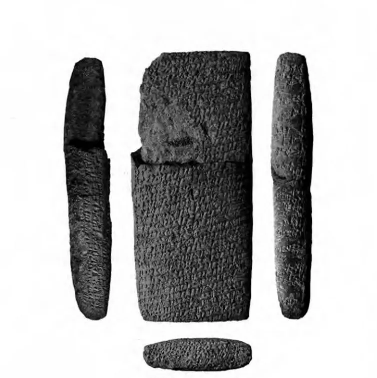
Figure 13.3. Reverse of the treaty between Kanis and the Assyrians (Kt 00/6, Kiiltepe,
P o l i t i c a l H i s t o r y o f t h e P l a t e a u
D u r i n g t h e K
a r u mP e r i o d
At the beginning o f the second millennium b.c.e., the Anatolian plateau appears to be politically fragmented. There were numerous centers, some o f them small forti fied city-states, others real territorial states, with a capital and several villages. We have almost no information about their hierarchy, but one can imagine that the Assyrians settled in the biggest and economically strongest ones. The data provided by the archives concern predominantly the Anatolian elite, that is, kings and palace officials with whom the Assyrian traders dealt; they also document each event that affected trade. The few extant Anatolian archives also deal with the trade and con sist mostly o f loans and sale contracts (Albayrak 2005; Donbaz 1988; Veenhof 1978).
Political Powers
Countries and Cities
The Assyrian vocabulary referring to Anatolian political powers is quite vague. The word for land, matum, refers to the territory of a city-state but corresponds as well to the countryside. During Karum II, the texts mention the lands o f Burushattum, Kanis, Luhusaddia (east o f Kanis), Wahsusana (north o f the Tuz Golu), and Zalpa, to the north. The toponym ^ ttu m does not correspond to a town but to the land inside the Kizil Irmak bend; it contained several cities, among which are Amkuwa, Hattus, Tawinia, and Tuhpia (figure 13.1). During the Karum Ib period, the land of Mamma became more important, and both Kanis and Mamma had vassal states. The archives mention hundreds of toponyms corresponding either to small villages or to bigger towns which might be centers o f independent states (Michel 2008c). Twenty cities housed a karum during the Level II period' and fifteen a wabartum? During the Level Ib period, the data give a list o f fewer than ten kdrums^ and five wabartumsf important centers like Burushattum had disappeared from the Assyrian trade network, perhaps being too far west (Dercksen 2001:60-61; it could be located at Karahoyiik Konya).
Kanis might have been the first town settled by the Assyrians; it certainly remained their administrative center during the whole period. Anatolian archives as well as tablets from the citadel, with a list o f the palace personnel, give names of villages belonging to the Kanis state. During Karum II, the city was surrounded by ten or so villages; during Karum Ib, the kingdom was apparently even bigger, with almost twenty villages (Dercksen 2004; Forlanini 1992; Gtobatti 1987).
Anatolian Rulers and Political History
Each city-state, whatever its size, had its local dynasties. The Anatolian rulers were called rubd’um (“prince” ) and rubdtum (“princess” ) or designated with a nisbe (nisbes derive from a place-name and are used to indicate the geographical origin
322 CHRONOLOGY AN D GE O G RAPH Y
o f people and objects), for example, Wahsusanaium, “the Man o f Wahsusana.”^ A prince is attested during Karum II in more than fifteen towns;® in Burushattum, the local ruler is occasionally designated as the “great prince” {ruba’um rabium). The Assyrian archives never give the name o f the local king, except for Labarsa, whose accession to the throne o f an unknown city-state is used to date a transaction. At the end o f Kdrum II, a text mentions the death o f Luhusaddia’s prince, Asu (Kryszat 2008b:i56-59). Letters refer to hostilities, rebelhons, the death o f a local ruler, and so on, but no names or dates are given.
During Kdrum II, there are several mentions of coalitions between Anatolian kingdoms, for example, between Wahsusana and Kani§, and between the rulers of Sinahutum, Amkuwa, and Kapitra, who made an alliance against Hattus at the end o f Kdrum II or the beginning o f Kdrum Ib (Larsen 1972; Michel 200i:n0. 63). Simi larly, wars and hostilities between two cities are discussed in some letters because they could slow down or stop the trade. Thus, a conflict between Tawiniya and perhaps Washania involved an Assyrian accused by the second of acting as a spy for the first city (Giinbatti 2001; Michel 2008c; Michel and Garelli 1996). The western cities o f Burushattum and Wahsusana were often fighting against each other, some times involving Saladuwar; the Assyrian community had to leave Wahsusana at the end o f Kdrum II, while Burushattum became more influential (Barjamovic, Hertel, and Larsen forthcoming; Veenhof forthcoming). Several kingdoms experienced local revolts, for example in H a ^ u m , Kunanamit, Burushattum, Wahsusana, or in Ulama where turmoil started after the death o f the king (Michel 2008c; figure 13.1). Travels of kings are also mentioned because they disrupted the caravan traffic. These movements indicate the existence o f diplomatic and political contacts among the Anatolian rulers.
The situation is quite different during Kdrum Ib. Thanks to Anatolian legal documents that were written under the supervision o f the local ruler and/or the “chief o f the stairway” (Donbaz 1989,1993, 2004), it is possible to reconstruct the sequence of Kanis kings during this later period: Hurmeli (or ruler o f Mamma?), Harpatiwa, Inar and his son and successor Warsama, Pithana and his son and successor Anitta (Great King), and Zuzu (Great King) (Barjamovic, Hertel, and Larsen forthcoming; Dercksen 2004; Forlanini 1995, 2004, 2008; Kryszat 2008b:i6i-65, 2008c; Michel 2001:117-23; Veenhof 2008a:i67-73;).^ According to the letter sent by king Anum-Hirbi o f Mamma to Warsama o f Kanis and discov ered in the Kiiltepe palace, the king o f TaiSama (a vassal kingdom o f Kanis), taking advantage o f a defeat o f Anum-Hirbi, invaded his territory and looted some of his villages (Balkan 1957; Miller 2001). Anum-Hirbi, protesting, mentioned the long siege o f Harsamna by Inar. A recently excavated Old Assyrian letter sent to kdrum Kanis by Assur s assembly refers to the war between Harsamna and Zalpa, just after Isme-Dagan ascended the throne (Giinbatti 2005). A Hittite document, Anitta’s res gestae, also gives some elements o f Anatolian political history (Car- ruba 2003). Anittas father, Pithana, ruler o f Kussara, conquered Nesa (Kanis) during a night raid and captured its king, Warsama. Anitta, who became king of Kanis and Amkuwa, achieved also several military conquests and took the title
Great King. A bronze dagger bearing Anitta’s name was found in a building south east o f the citadel o f Kanis. Zuzu, king o f Alahzina, also conquered Kanis and took the title o f Great King for himself; he ruled at the end o f the eighteenth cen tury B .c .E . The end o f Kdrum Ib might in fact be the result o f Anatolian rivalries
between several powerful kingdoms.
During Kdrum la, there were still foreign travelers in Kanis according to the archaeological remains, such as “Syrian bottles” or a Mesopotamian cylinder seal (Emre 1995, 1999; Kulakoglu 2008), but no epigraphic material is extant from this period.
THE K A R U M PERIOD ON THE P L AT E A U 323
The Anatolian Palace and its Administration
The prince or royal couple lived in the palace, a huge building that represented the center o f the Anatohan administration and could host hundreds o f people; the enclosure wall o f the Kiiltepe Ib palace is 110 x 120 m (T. Ozgii^ 2003:187-92, and see Kulakoglu, chapter 47 in this volume). During Kdrum II, the palaces, which are the local authorities with whom the Assyrians had to deal, are attested for several towns,® but for Kdrum Ib, only the palace o f Salahsuwa is mentioned. The palace administration, headed by the royal couple, comprised many officials in charge o f different services, workers, and craftsmen. The archives quote fifty different Anato lian titles; this high number indicates that the Anatolian administration was highly structured. The titles referred to in the Old Assyrian texts are translations into Assyrian o f Anatolian realities. Among the highest officials, the “chief o f the stair way” could correspond to the crown prince, whereas the rabi sikkitim (“chief of the . . .”) had military and trade duties. The “chief scepter bearer,” the “chief cup bearer,” and the “chief o f tables” were directly attached to the service o f the king. The craftsmen were under the supervision o f the “chief o f the workers,” distributed among various services, each o f them with a chief (“chief o f the fullers,” “chief o f the blacksmiths,” etc.). The duties o f some others are not clear to us, for example the
sinahilum, “man in second” or the steward (alahhinnum). It was possible to bear two
different titles, and some o f these could be given by the prince in exchange for a gift (Veenhof 2ooSa:2i9-45).
E
c o n o m y a n dT
r a d eThe Anatolian palaces were also economic centers that dealt with the Assyrian mer chants: their wealth came from the production o f their fields and their metallurgical resources. But they were also in need of tin, textiles, and other raw material brought by the Assyrians.
Agriculture, Animal Husbandry, and Food Production
The economy o f the Anatolian cities was mainly based on agriculture and animal husbandry, depending on villages and domains. The land was owned by farmers and palace officials, although some fields belonged to the palace itself. The rest of the population—town inhabitants and foreign merchants in the kdrum—had no land and depended on the surplus food sold on the market (Dercksen 2008a). Along the roads, some inns were able to feed huge quantities o f people and animals form ing the Assyrian caravans. Some lands were linked to a service obligation (tuzin-
num); domains {ubadinnum) were offered by the king to its high officials (Dercksen
2004 and later discussion herein). Some private properties {betum) also existed. The landowners had to give part o f their harvest to the palace in taxes. The owners of whole villages could provide enormous amounts of grain in loans, whereas poor farmers could only produce for their own subsistence and were obliged to borrow grain from local dignitaries, palace officials, and priests to make it to the next har vest, sometimes giving their own fields as security. Joint land ownership was quite common. Anatolian loan contracts are dated according to the agricultural calendar.
Archaeobotanical studies at Kaman K aleh o y^ counted half a dozen cereal vari eties, but according to the texts, the biggest part of the nonirrigated land was planted with barley and wheat (Dercksen 2008b). The grain might be put in large bags to be sold on the market or in huge jars to be stored in palace storerooms under the responsibility of a “chief of the storehouses.” Cereals were ground into flour to make bread or prepared into different kinds of bulgur and porridges, and fermented barley and malt were used to prepare beer (Michel 1997,2009). Sesame oil was used for food but also for lamps and perfumes; a “chief of oil” was in charge o f the collection of oil and its distribution inside the palace. Hatoum and Kanis are well known for their oil production. Irrigated parcels were used as orchards whose owners had to pay a tax to the chief of the irrigated fields. In the gardens, people grew vegetables, fruit trees, and animal fodder (Michel 1997; Sturm 2008). They also cultivated aromatic plants and spices. The palace had its own orchards, with gardeners. Grapes were cultivated north o f Kanis and made into wine.
The steppe and fallow fields were used as pasture for herds o f sheep and goats. These animals were bred for their meat and fat, their milk, and their wool, which was sold by the palace. Wool from Mamma and Luhusaddia could be found in mar ketplaces. The “chief o f the herdsmen” could be very wealthy. According to the
Kdrum Ib letter of the king o f Mamma, the palace owned horses, mules, dogs, and
oxen (Dercksen 2008a). Archaeozoological studies in Kaman Kalehoyiik and Acemhoyuk show that Anatolians ate mainly sheep and goats, as well as some cattle and pigs. In private gardens, people could keep a few animals, but the consumption o f meat was a privilege o f wealthy people (Michel 1997, 2006c).
3 2 4 CHRONOLOGY AND G E O G RAPH Y
Metal Resources
Mining and metallurgy were the other main resource o f the Anatolian plateau (Dercksen 2005; see Muhly, chapter 39 in this volume). Metal production was a
THE K A R U M PERIOD ON THE P L AT E A U 325
prim ary attraction for the Assyrians, who wanted to bring gold and silver back to their homeland. There were galena and argentiferous lead deposits in the area o f Bolkardag, south o f Nigde, in the Taurus Mountains (Yener 1986). Silver was also found further west, in the area o f Burushattum, a main silver market according to the texts. The metal was melted, refined, and circulated in the form o f ingots, bracelets, rings, and scraps. Silver was the main means o f payment in Anatolia besides copper and grain. Part o f the silver was exchanged for gold by the Assyri ans. There were sources o f gold in the west and southwest o f Anatolia (Jesus 1980) and in the Hahhum Mountains, northeast o f Malatya (Gudea, Statue B, vi 33-35; Edzard 1997:34). The Assyrians could buy gold in Burushattum, Wahsusana, Durhumit, and Kanis. The metal circulated in the form o f nuggets, rings, beads, and various objects; one shekel (about 8.3 g) o f gold amounted to six to eight shekels o f silver.
Many Anatolian copper mines were exploited during the kdrum period; this very cheap metal was used as a means o f payment for daily products or small pur chases, to make objects, or alloyed with tin to produce bronze. The main copper exploitations were located along the Black Sea coast in the area o f the Kizil Irmak or near Ergani (Dercksen 1996). Thus, Durhumit appears to have been the location o f the principal copper market, besides Taritar or Tismurna, which produced poor-quality copper (Michel i99i:fig. 13.1). From there, the Assyrian merchants brought the metal in huge quantities to the western and southern cities o f Burushattum and Wahsusana, or to Kanis, to exchange it, after treatment, for sil ver. The metal was sold in the form o f ingots, small blocks, scraps, or even old sickles. To prepare the bronze needed in daily activities, Anatolians depended on the Assyrian caravans bringing the tin from the northwest o f Iran and Uzbekistan. Three circular tin ingots, weighing between twenty-five and fifty grams, have been found in a Kdrum Ib house at Kanis. The bronze was produced locally, by Anato lian metalworkers (Sturm 2001), to make tools, weapons, and household objects, many o f which have been found in the houses and graves o f the kdrum: spearheads, axes, daggers, forks, needles, nails, and chains (T. Ozgii9 1986, 2003). The textual documentation mentions a variety o f pots, cauldrons, knifes, spoons, hoes, axes, sickles, and so on (Dercksen 1996:76-80). Metal workshops have been found at Kultepe; they contained numerous molds for bronze tools, weapons, and ingots (Miiller-Karpe 1994:49-66; T. Ozgiic; 1986:39-51). Other metals circulated in small quantities, such as the expensive native iron imported from Assur or found on the plateau in small deposits; two iron blocks have been unearthed in Peruwa’s house in the kdrum o f Kanis.
Trade and Commercial Treaties
The inhabitants o f Kanis could buy grain, slaves, animals, and various commodities on the local market. For tin and textiles, the palace and the elite dealt with the Assyrian merchants; the exchanges were ruled by commercial treaties concluded
with each Anatolian ruler. According to these texts, in exchange for several taxes levied on the Assyrian caravans in both directions, the Anatolian ruler promised to protect individuals and goods. In case o f murder, he had to deliver the murderer. If goods were lost, he had to replace them. If caravan traffic was stopped because of war, he was sure to be supplied with tin. The Assyrians were settled in kdrums and
wabartums that were legally independent from the local authorities. They were pro
tected in the kdrums as well as on the roads. Anatolian rulers were eager to sign the treaties that guaranteed these relationships to get some profit out o f the trade, which was mutually beneficial to both parties.
Kdrum Ib treaties found in Kanis and concluded with the ruler of Kanis, during
the reign of Anitta or Zuzu, and with HaMium dignitaries (Gunbatti 2004) show a slightly different situation than during Kdrum II. Some Assyrians, settled in Kanis and not involved any more in the international trade, were less rich, being strongly indebted and even detained by Anatolians as debt slaves, whereas during the former period, Anatolian rulers had to “wash the debts” o f the local population, who were often deeply indebted to Assyrians. In Hahhum, three dignitaries were allowed to levy taxes and receive gifts; the “export ministry,” the “second in command,” and the “son-in-law” (Veenhof 20083:147-82).
3 2 6 CHRONOLOGY AN D GEOGRAPHY
T
h eS
o c i e t y o fK
a n i sSocial Classes of Anatolian Society
Anatolian society showed an important difference between the palace and its high officials on one hand, and the rest o f the population, predominantly famers and shepherds, on the other. These latter were free but poor people who belonged to the lower class (hupsum); they were cultivating just enough land for their family subsis tence and often had to borrow grain to survive. The land belonged predominantly to the urban elite and to the palace. The high palace officials received some domains and even whole villages from the king, either as a gift that could be sold or as com pensation for a service obligation (Dercksen 2004). There were different kinds of service obligation. The arhdlum, originally an agricultural tool, encompassed sev eral forms of service, among which was the unussum corvee, attested during Kdrum Ib (Dercksen 2004:140-47).
Slaves were in charge o f different tasks in the households; many o f them were debt slaves, sold into slavery by themselves or by a parent. They could be redeemed if double (or more) o f the original price was paid within a restricted time limit. Anatolian slave sales were supervised by the local ruler or his repre sentative; the seller was liable to heavy penalties in the case o f a claim against the buyer.
Ethnic Origins of the Kanis Population
In the kdrum, Assyrians lived near local merchants. They owned a house in the
karum, and bought slaves, food, oil, and wood from the local population. They
apparently did not wish to own land, but some Assyrians had a field gained as security for a loan. The Assyrians referred to local inhabitants as nuwa’um (Anato lian) without any distinction, but onomastic studies provide us with some clues about their ethnic origin. The anthroponyms quoted in the tablets belong to sev eral different languages, as indicated by some loanwords: Hattie, Luwian, Hittite, and Hurrian (Dercksen 2002; Garelli 1963:127-68; Goedegebuure 2008; Michel 2001:40-41; Wilhelm 2008). The Hattian people spoke an agglutinative language that does not belong to any known linguistic family; they were already settled in the bend o f the Kizil Irmak in the third millennium b.c.e. The Indo-European Luwians arrived in central Anatolia during the last centuries o f the third millen nium B.C.E. The Hittites came into this area perhaps at the very beginning o f the second millennium b.c.e., and they adopted many cultural features o f the Hat- tians. The Indo-European Hittite language was later called nesili, “from the city o f Nesa” (Kanis). Hurrians arrived from the mountains o f Upper Mesopotamia and were well established in the eastern part o f Anatolia during the Karum Ib period; the best-known king bearing a Hurrian name was Anum-Hirbi, king o f Mamma (Wilhelm 2008).
THE K AR t/M PERIOD ON THE PL AT E A U 3 2 J
Communication between Assyrians and Anatolians
Assyrians and Anatolians apparently had no communication problems, so bilin gualism must have been fairly common. The very few translators mentioned in the documents were employed by the palace administrations (Michel 2008a, 2010; Ulshofer 2000; Veenhof 1982). The Assyrians introduced writing to Anatolia, and there is no evidence o f an attempt by the Anatolians to adapt the cuneiform script to their language during the karum period. Old Assyrian was used in the commer cial treaties drawn between Assyrians and local rulers; it even served as the diplo matic written language between the Anatolian kings. Treaties and royal letters were certainly written by official scribes employed by the palaces. Some Anatolians, such as Peruwa, whose archives were discovered in the karum, adopted the cuneiform script and Old Assyrian dialect. In fact, the Assyrians themselves used a simplified cuneiform script with fewer than 200 signs. Many Assyrians were able to read and write, and this might have encouraged the local people to learn to read and write as well (Kryszat 2008a; Michel 2008a).
The Old Assyrian dialect shows several loanwords borrowed from the Hattie language spoken in the city at least since the beginning of the nineteenth century
B.C.E. (Dercksen 2007). Moreover, some Anatohan officials bore titles that did not exist in the Assyrian administration and were thus translated from Hittite or built on Hurrian words; this makes the work o f the historians who try to understand the function and activities behind them more complicated.
Family
Marriage and divorce contracts give information on local family law. Husband and wife enjoyed equal status, and they owned house and goods in common. Both could divorce, and contracts were established under the supervision o f the local ruler and his second-in-command. In case o f divorce, they shared their house, or the wife could take everything out o f the house, including the slaves, and give up her rights on the domain and the linked service obligation (tuzinnum). Once the divorce was settled, if the husband or wife made a claim, he or she was subject to a heavy fine and there could even be a death penalty (Veenhof 2003b). After the divorce, chil dren were brought up by either the wife or the husband. When an Anatolian was indebted, he could give his wife and children as a guarantee to his creditor; if he could not pay his debt, then his wife and children became the property o f the cred itor and they lost their liberty (Michel 2003b).
Adoption is also attested; the adopted child lived with his or her new family. Adults were adopted for economic reasons. One tablet describes a couple who adopted a young man, who then had to sustain his new parents and became their unique heir (Michel 1998; Veenhof 2003b). Several Anatolian contracts dated from
Karum Ib show joint ownership among two to four young men presented as brothers {athu)\ they had to share the household with their old parents, even if some o f them
were already married, to maintain an economically strong household. They thus shared the service duties linked to the property. They could divide the property between them only after the death o f their parents (Veenhof 1997).
3 2 8 CHRONOLOGY AN D GEOGRAPHY
The Mixed Community
The relationships between Anatolians and Assyrians were primarily commercial. The first generation o f Assyrians who came to Anatolia was made up from men who left their families in Assur; their involvement in the Anatolian society was a purely economical one. They stayed for a while in Anatolia and came back to Assur because they had to take over their family affairs. As more and more Assyrians settled in Kanis and in other kdrums and wabartums, the relations between the two popula tions changed (Michel 2010; Veenhof 1982). During their long stay in Anatolia, the Assyrians often contracted a second marriage, most o f the time with an Anatolian woman. This was done with respect to two rules: they could not have two wives with the same status {assatum, “main wife,” amtum, “secondary wife” ), and they could not have both wives in the same place (Kienast 2008; Michel 2006b; Veenhof 2003b). The Anatolian wives o f the Assyrian merchants stayed at home in Kanis, bringing up their children, taking care o f the household, and doing agricultural tasks, while their husbands were traveling and trading inside Anatoha and sometimes as far as to Assur where their Assyrian wives were waiting for them. When some of the Assyrians went to retire in Assur, they left their Anatolian wives and drew up a divorce contract; the women typically could keep the house in which they lived, the furniture, and some divorce money (Michel 2008b). They usually kept their younger
children, the father paying for their upbringing, but he could decide to take some of his Anatolian children to Assur.
Many Anatolians living in the kdrum could improve their position in society through the business they conducted with the Assyrians. Some even acted as credi tors toward Assyrians and integrated with the Assyrian family firms by choosing their spouses from among the Assyrian community. With the increase o f mixed marriages, the kdrum became a “social colony” —so much so that in several families, brothers and sisters bore Assyrian as well as Anatolian names.
THE K A R U M PERIOD ON THE PL AT E A U 329
C
o n c l u s i o nThe Old Assyrian presence in Anatolia, known best through its archives excavated at Kiiltepe, gives an important insight into local culture and history. During the
kdrum period, the Anatolian plateau was divided into city-states and small territo
rial states, which, through coalitions and wars, became more or less influential. Each state had its own dynasty, with a prince or royal couple who lived in the palace, which represented the state administrative center. Anatolian states developed a very highly organized administration, according to the fifty official titles mentioned in the Old Assyrian archives, without having their own writing system.
The Assyrian presence in central Anatolia during the nineteenth and eighteenth centuries b.c.e. did not have a political character but was purely economic. The Assyrians represented the most numerous foreign people in Anatolia and the best structured community in the kdrum of Kanis, where they lived together with local inhabitants and other foreigners. The relationships between Assyrians and Anato lians were first commercial and then evolved with an increasing number o f mixed marriages between the two communities into a “social colony.”
The nineteenth century b.c.e. is very well documented, but there are many fewer tablets for the eighteenth century b.c.e., and we do not know how the Old Assyrian trade in Anatolia came to an end. A general impoverishment o f the Assyr ians not involved anymore in the international trade can be observed. Their depar ture seems to be the consequence o f a deteriorated political situation among the Anatolian states. With the departure of the Assyrians, writing disappeared from Anatolia within a century, to be reintroduced later in a different form by the Hittites.
NOTES
1. Burushattum, Durhumit, Hahhum, Hattus, Kani§, Nihria, Nenassa, Saladuwar, Salahsuwa, Samuha, Simala, Sinahutum, Tawinia, Tegarama, Timilkia, Tismurna, Tuhpiya, Ursu, Wahsusana, southern Zalpa.
2. Amkuwa, Hanaknak, Hurrama, Kara^a, Kuburnat, Kussara, Mamma, Samuha, Suppilulia, Ulama, Upe, Ussa, Washania, northern Zalpa, Zimishuna.
3. Durhumit, KaniS, Kuburnat, Samuha, Saladuwar, Suppiluha, Tawinia, Tegarama, Wahlusana?, Washania.
4. Amkuwa, Hurrama?, Mamma, Samuha, Tegarama, Timilkia?.
5. Some rulers are mentioned by a nisbe in Hattus, NenasSa, Wahsusana, and Timilkia.
6. Amkuwa, Burushattum, Durhumit, Hattus, Hurrama, Kanis, Kuburnat, Luhusaddia, Mamma, NenaJJa, Sinahutum, Tawinia, Timilkia, Tuhpia, WahSuiana, Washania.
7. During this period, rulers are also attested in Amkuwa, Kanis, Luhusaddia, Mamma, SalahJuwa, and Tawinia.
8. Burushattum (Garelli 1989), Durhumit (Michel 1991), Hurrama, Kanis,
Luhusaddia, Nihria, Nenassa, Samuha, Tegarama, Tismurna, Wahsusana, Washania, and both Zalpas.
3 3 0 CHRONOLOGY AN D GEOGRAPHY
REFERENCES
Albayrak, Irfan. 2005. Fiinf Urkunden aus dam Archiv von Peruwa, Sohn von Suppibra.
Jaarbericht van het Vooraziatisch—Egyptisch Genootschap Ex Oriente Lux 39: 95-105.
Alp, Sedat. 1968. Zylinder und Stempebiegel aus Karahdyuk bei Konya. Turk Tarih Kurumu Yayinlarmdan V/26. Ankara: Turk Tarih Kurumu Basimevi.
Balkan, Kemal. 1957. Letter of King Anum-Hirbi of Mama to King Warshama ofKanish. Turk Tarih Kurumu Yayinlarmdan VII/3ia. Ankara: Tiirk Tarih Kurumu Basimevi.
Barjamovic, Gojko. 2008. The Geography of Trade. Assyrian Colonies in Anatolia c. 1975-1725 BC and the Study of Early Interregional Networks of Exchange. In Anatolia
and the Jazira during the Old Assyrian Period, ed. Jan Gerrit Dercksen, 87-100. Old
Assyrian Archives Studies 3. Pubhcations de ITnstitut historique-archeologique neerlandais de Stambul CXI. Leiden: Nederlands Instituut voor het Nabije Oosten. ---. 2011. A Historical Geography of Anatolia in the Old Assyrian Colony Period. Carsten
Niebuhr Institute Publications 38. Copenhagen; Copenhagen University.
Barjamovic, Gojko, Thomas Hertel, and Mogens T. Larsen. Forthcoming. Ups and Downs at
Kanesh—Observations on Chronology, History and Society in the Old Assyrian Period.
Old Assyrian Archives Studies 5. Publications de ITnstitut historique-archeologique neerlandais de Stambul. Leiden: Nederlands Instituut voor het Nabije Oosten. Blocher, Felix. 2003. Chronological Aspects of the Karum Period (Middle Bronze Age).
In The Synchronisation of Civilisation in the Eastern Mediterranean in the Second
Millennium B.C., vol. 2, ed. Manfred Bietak, 379-80. Wien: Verlag der
Osterreichischen Akademie der Wissenschaften.
Carruba, Onofrio. 2003. Anitta res gestae. Anitta, King of the Hittites. Studia Mediterranea 13, Series Hethaea 1. Pavia: Italian University Press.
Qe^en, Salih and Karl Hecker. 1995. Ina matika eblum, Zu einem neuen Text zum Wegerecht. In Festschrift ftir Wolfram Freiherrn von Soden zum 85. Geburtstag am 19.
Juni 1993, ed. Manfred Dietrich and Oswald Loretz, 31-41. Alter Orient und Altes
Dercksen, Jan Gerrit. 1996. The Old Assyrian Copper Trade in Anatolia. Publications de rinstitut historique-archeologique neerlandais de Stambul 75. Leiden: Nederlands Instituut voor het Nabije Oosten.
---. 2001. “When We Met in Hattus.” Trade According to Old Assyrian Texts from Alishar and Bogazkoy. In K.R. Veenhof Anniversary Volume, ed. Wilfred H. van Soldt, J. G. Dercksen, N. J. C. Kouwenberg, and T. J. H. Krispijn, 39-66. Publications de rinstitut historique-archeologique neerlandais de Stambul 89. Leiden: Nederlands Instituut voor het Nabije Oosten.
---. 2002. Kultureller und wirtschaftlicher Austausch zwischen Assyrern und Anato-liern (Anfang des zweiten Jahrtausends v. Chr.). In Brtickenland Anatolien? Ursachen,
Extensitdt und Modi des Kulturaustausches zwischen Anatolien und seinen Nachbarn,
ed. Hartmut Blum, Betina Faist, Peter Pfalzner, and Anne M. Wittke, 35-43. Tubingen: Attempto Verlag.
---. 2004. Some Elements of Old Anatolian Society in Kanis. In Assyria and Beyond.
Studies Presented to Mogens Trolle Larsen, ed. Jan Gerrit Dercksen, 137-78. Publica
tions de rinstitut historique-archeologique neerlandais de Stambul C. Leiden: Nederlands Instituut voor het Nabije Oosten.
---. 2005. Metals According to Documents from Kultepe-Kanish Dating to the Old Assyrian Colony Period. In Anatolian Metal III, ed. U. Yalcun, 17-34. Der Anschnitt, Beiheft 18. Bochum: Deutsches Bergbau-Museum.
---. 2007. On Anatolian Loanwords in Akkadian Texts from Kiiltepe. Zeitschrift fUr
Assyriologie 97: 26-46.
---. 2008a. Subsistence, Surplus and the Market for Grain and Meat at Ancient Kanesh.
Altorientalische Forschungen 35; 86-102.
-. 2008b. Observations on Land Use and Agriculture in Kanes. In Old Assyrian
THE K A R U M PERIOD ON THE PLAT E A U 33I
Studies in Memory of Paul Garelli, ed. Cecile Michel, 139-57 Leiden Old Assyrian
Archives Studies 4. Publications de ITnstitut historique-archeologique neerlandais de Stambul 112. Leiden: Nederlands Instituut voor het Nabije Oosten.
Donbaz, Veysel. 1988. The Business of Ased, an Anatolian Merchant. Archivfiir Orientforsc-
hungis: 48-63.
---. 1989. Some Remarkable Contracts of i-B Period Kiiltepe Tablets. In Anatolia and the
Ancient Near East. Studies in Honor of Tahsin Ozgiif, ed. Kutlu Emre, Barth el Hrouda,
Machteld MeUink, and Nimet Ozgu^, 75-98. Ankara: Tiirk Tarih Kurumu Basimevi. -. 1993. Some Remarkable Contracts of i-B Period Kiiltepe Tablets II. In Aspects of Art
and Iconography: Anatolia and its Neighbors. Studies in Honor of Nimet Ozgiif,ed. Machteld J. Mellink, Edith Porada, and Tahsin Ozgiif, 131-54. Ankara: Tiirk Tarih Kurumu Basimevi.
-. 2004. Some Remarkable Contracts of i-B Period Kiiltepe Tablets III. In ^arnikzel.
Hethitologische Studien zum Gedenken an Emil Orgetorix Forrer, ed. Detlev Groddek
and §evket Rofile, 271-84. Dresdner Beitrage zur Hethitologie 10. Dresden: Harras- sowitz Verlag.
Donmez, §evket and Aslihan Y. Beyazit. 2008. A General Look at the Central Black Sea Region during the Middle Bronze Age and a New Approach to the Zalpa Problem in the Light of New Evidence. In Anatolia and the Jazira during the Old Assyrian Period, ed. Jan Gerrit Dercksen, 101-35. Old Assyrian Archives Studies 3. Publications de ITnstitut historique-archeologique neerlandais de Stambul 111. Leiden: Nederlands Instituut voor het Nabije Oosten.
Edzard, Dietz Otto. 1997. Gudea and His Dynasty. The Royal Inscriptions of Mesopotamia, Early Periods 3/1. Toronto: University of Toronto Press.
T
Eidem, Jesper. 1991. An Old Assyrian Treaty from Tell Leilan. In Marchands, diplomates et
empereurs. Etudes sur la civilisation mesopotamienne offertes a Paul Garelli, ed.
Dominique Charpin and Francis Joannas, 185-207. Paris: fiditions Recherche sur les Civilisations.
Emre, Kutiu. 1995. Pilgrim-Flasks from Level I of the Kdrum of Kani?. Bulletin of the
Middle Eastern Culture Center in Japan 8:173-200.
---. 1999. Syrian Bottles from the Karum of Kani?. Bulletin of the Middle Eastern Culture
Center in Japan 11: 39-50.
-. 2008. A Group of Metal Vessels from Karum Kiiltepe/Kanes. In Old Assyrian
332 CHRONOLOGY AND GEOGRAPH Y
Studies in Memory of Paul Garelli, ed. Cecile Michel, 3-12. Leiden Old Assyrian
Archives Studies 4. Publications de ITnstitut historique-archeologique neerlandais de Stambul 112. Leiden: Nederlands Instituut voor het Nabije Oosten.
Forlanini, Massimo. 1992. Am Mittleren Kizilirmak. In Hittite and Other Anatolian and
Near Eastern Studies in Honour ofSedat Alp, ed. Heinrich Otten, Ekrem Akurgal,
Hayri Ertem, and Aygiil Siiel, 171-79. Ankara: Tiirk Tarih Kurumu Basimevi. ---. 1995. The Kings of Kanis. In Atti del II Congresso Internazionale di Hittitologia, ed.
Onofrio Carruba, Mauro Giorgieri, and Clelia Mora, 123-32. Studia Mediterranea 9. Pavia; Centro ricerche egeo-anatoliche dell’Universita di Pavia.
---. 2004. La nascita di un impero. Considerazioni sulla prima fase della storia hittita: da Kanis a Hattusa. Orientalia 73: 363-89.
-. 2008. The Historical Geography of Anatolia and the Transition from the Karum-Period to the Early Hittite Empire. In Anatolia and the Jazira during the Old Assyrian
Period, ed. Jan Gerrit Dercksen, 57-86. Old Assyrian Archives Studies 3. Publications
de ITnstitut historique-archeologique neerlandais de Stambul 111. Leiden: Nederlands Instituut voor het Nabije Oosten.
Garelli, Paul. 1963. Les Assyriens en Cappadoce. Bibliotheque archeologique et historique de ITnstitut fran9ais d’archeologie dTstanbul 19. Paris: Institut fran^ais d’archeologie dTstanbul.
---. 1989. Le marche de BuruShattum. In Anatolia and the Ancient Near East. Studies in
Honor ofTahsin Ozgug, ed. Kutlu Emre, Barthel Hrouda, Machteld Mellink, and Nimet
Ozgii^, 149-52. Ankara: Tiirk Tarih Kurumu Basimevi.
Goedegebuure, Petra M. 2008. Central Anatolian Languages and Language Communities in the Colony Period: A Luwian-Hattian Symbiosis and the Independent Hittites. In
Anatolia and the Jazira during the Old Assyrian Period, ed. Jan Gerrit Dercksen,
137-80. Old Assyrian Archives Studies 3. Publications de ITnstitut historique- archeologique neerlandais de Stambul 111. Leiden: Nederlands Instituut voor het Nabije Oosten,
Gorny, Ronald L. 1995. Hittite Imperialism and Anti-Imperial Resistance as Viewed from Ali^ar Hoyiik. Bulletin of the American Schools of Oriental Research 299/300: 65-89.
Giinbatti, Cahit. 1987. Yeniden l^lenen Bir Kiiltepe Tableti (Kt g/t 42+z/t 11). Belleten 51:1-10. ---. 2001. The River Ordeal in Ancient Anatolia. In K. R. Veenhof Anniversary Volume,
ed. Wilfred H. van Soldt, J. G. Dercksen, N. J. C. Kouwenberg, and T. J. H. Krispijn, 151-60. Publications de ITnstitut historique-archeologique neerlandais de Stambul 89. Leiden: Nederlands Instituut voor het Nabije Oosten.
---. 2004. Two Treaty Texts Found at Kultepe. In Assyria and Beyond. Studies Presented
to Mogens Trolle Larsen, ed. Jan Gerrit Dercksen, 249-68. Publications de ITnstitut
historique-archeologique neerlandais de Stambul C. Leiden: Nederlands Instituut voor het Nabije Oosten.