actes 2009
bis
actes
2009 bis
5
th
International Symposium
on Lithographic Limestone
and Plattenkalk
Abstracts and Field Guides
Edited by
Jean-Paul Billon-Bruyat, Daniel Marty, Loïc Costeur, Christian A. Meyer & Basil Thüring
Actes 2009 bis
De la
Société juraSSienne D’émulation
année 2009
cent Douzième année
5
th
International Symposium
on Lithographic Limestone
and Plattenkalk
Naturhistorisches Museum Basel, switzerland
August 17
th-22
nd, 2009
Abstracts and Field Guides
edited by
Jean-Paul Billon-Bruyat, Daniel Marty, Loïc costeur, christian A. Meyer & Basil thüring
Publié grâce au soutien financier de PaléoJura, Office de la culture, Porrentruy
Soutien administratif d’antoinette Hitz (naturhistorisches museum Basel) Soutien pour la relecture de catherine Friedli
(office de la culture, Section d’archéologie et paléontologie, Porrentruy) Soutien pour la conception de la Société jurassienne d’emulation
tous droits réservés
tant pour le texte que pour les illustrations note du comité directeur
les opinions exprimées par les auteurs sont personnelles et n’engagent en rien ni la Société ni le comité directeur.
responsable des Actes: martin choffat
© 2009, Société jurassienne d’emulation 8, rue du Gravier, cH-2900 Porrentruy
www.sje.ch
imprimé par le centre d’impression le Pays, Porrentruy iSSn 1011-2820
Field-trip to the excavations
in the Late Jurassic along the future
Transjurane highway near Porrentruy
(Canton Jura, NW Switzerland):
dinosaur tracks, marine vertebrates
and invertebrates
Daniel mArtY & Jean-Paul BilloN-BrUYAt
Palaeontology a16, Section d’archéologie et paléontologie, office de la culture, Hôtel des Halles, P.o. Box 64, 2900 Porrentruy 2, Switzerland (daniel.marty@palaeojura.ch)
1. introduction
this one-day field-trip (21.08.2009) to the late jurassic palaeontologi-cal excavations sites along the future course of the federal highway a16 “transjurane” near Porrentruy (canton jura, nW Switzerland) accompa-nies the 5th international Symposium on lithographic limestone and
Plattenkalk.
First, we will visit the excavations in the late Kimmeridgian marnes à
virgula. these claystones are extremely rich in small oysters (“Exogyra vir-gula”, Nanogyra sp.) and they frequently bear marine vertebrates, notably
fishes, turtles and crocodilians. Besides remains of marine vertebrates, the under- and overlying (marly) limestones yield a diverse and rich invertebrate fauna, which was first described by thurmann & etallon (1861-1864). it is thus possible to collect typical jura fossils such as Ceratomya sp., Homomya sp., Pholadomya sp., Sellithyris sp., and others on the excavation sites.
afterwards, we will move to two dinosaur tracksites, which are situ-ated in immediate geographic and stratigraphic proximity to the marnes à virgula excavations. the tracksites are located in two different laminite intervals of slightly different age at the transition from the early to the late Kimmeridgian. tracks of sauropod and theropod dinosaurs will be observed during daylight and after dinner at night. therefore, we will install a special nocturnal illumination; so don’t forget to bring your camera!
Because the visited sites are located close to active highway construc-tion sites we will have to provide you with safety vests, and we recom-mend you to wear good (closed) shoes.
1.1 History of the Palaeontology A16
even though in Switzerland archaeological survey projects exist for federal highways since 1960, the importance of safeguarding the palae-ontological heritage was only recently recognized. as a result of the con-struction of the transjurane highway a new project, further named Palaeontology a16, was established in February 2000 in the canton jura. initially named Section de paléontologie, this project is now integrated in the Section d’archéologie et paléontologie of the Office de la culture of the canton jura. the Palaeontology a16 is financed by the Swiss Federal roads authority (95%) and the canton jura (5%). its purpose is to exca-vate and document the palaeontological heritage along the future highway course in the canton jura, and to make it accessible for scientific research (e.g., marty & Hug, 2003; Hug et al. 2004; marty et al., 2004; ayer et al., 2005, 2006).
1.2 Methodology of the Palaeontology A16
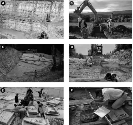
Palaeontological and sedimentological prospection combined with geo-logical mapping determines the approximate position of the most promising beds on the highway course (Fig. 1a). afterwards, prospective excavations are performed using a shovel excavator (Fig. 1B). if significant findings are made, an excavation can be planned. large-scale excavations may last up to several years and are carried out well before the construction of the high-way, scheduled in agreement with the civil engineering office (Fig. 1c, D). important discoveries are sometimes made during the construction of the highway. in this case, a suitable solution for an emergency excavation has to be worked out with the highway engineers in charge.
the excavation of macrofossils happens in the field applying classical palaeontological techniques (Fig. 1D) but also include the use of heavy machines to extract large blocs (Fig. 1e). microfossils are isolated in the laboratory by screen-washing. modern documentation techniques such as laser scanning (leica Geosystems 2003) and photogrammetry (Fig. 2) are also applied (see also Paratte et al. this volume). this completes the clas-sical documentation techniques such as graphic documentations (Fig. 1F) and casts, and enables a virtual reconstruction of the tracksites (e.g., Hurum et al. 2006; Bates et al. 2008a, b). this is particularly important,
figure 1: methodology of the palaeontology a16. A: the study of reference quarries is
impor-tant to locate fossiliferous beds on the highway course. the “la combe” quarry near chevenez is a reference section (jank et al. 2006a, b) for the upper reuchenette Formation (early to late Kimmeridgian). the section that can be observed during the excursion is located between the
intermediate levels and the coral limestones. B: Palaeontological prospecting (near Porrentruy)
allows identifying the most important beds and determines the approximate position of a future
excavation area. c: excavation of the main track level at the chevenez–combe ronde tracksite.
overburden was removed with heavy shovel excavators. this site is meanwhile protected by
the extension of the highway bridge, which is visible in the upper left of the picture. D:
excavation of the marnes à virgula with a shovel excavator. in the foreground a branch of a
wood is uncovered with fine handtools (photograph by Patrick Dumas / look at Sciences). e:
extraction of a track-bearing surface, cut into several blocs, at the courtedoux–Bois de Sylleux
tracksite, level 1040. f: Graphic documentation of a turtle carapace in the marnes à virgula
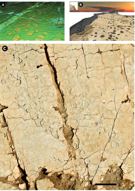
figure 2: High-resolution (in the order of 1-2 mm) laserscanning and close-range (2-10 m from
camera to object) photogrammetry of dinosaur track-bearing surfaces. A: laserscan of a
cross-roads of three sauropod trackways (courtedoux–Sur combe ronde tracksite, main track level).
B: Virtual 3D model of a track-bearing surface based on photogrammetric and laserscanning data
(courtedoux–tchâfouè, main track level). c: Photogrammetry of a surface with several parallel
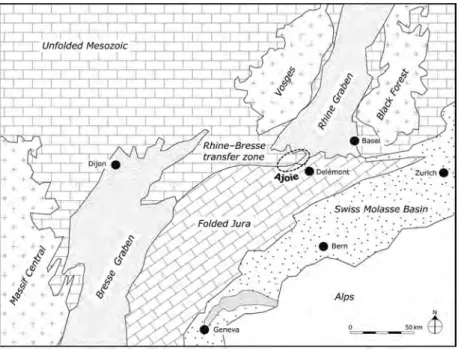
figure 3: A: Geographical setting of the ajoie district (nW Switzerland) and the late jurassic
excavations and tracksites along the transjurane highway; inset shows location within
Switzerland. the box encompasses the map shown in B. B: close-up of the area around
courtedoux and chevenez with the tracksites of the transjurane highway and the trackways outside the highway indicated. From north to south: (1) courtedoux–Béchat Bovais, (2) courtedoux–Bois de Sylleux, (3) courtedoux–Pommerats, (4) courtedoux–oratoire, (5) courtedoux–tchâfouè, (6) chevenez–combe ronde, (7) courtedoux–Dessus latchire, (8) courtedoux–Sur combe ronde and (9) chevenez–crat. the field trip will lead us to the “Bois de Sylleux” and “Béchat Bovais” sites. the marnes à virgula are currently excavated at the courtedoux–Bois de Sylleux. other sites where the marnes à virgula were or will be excavated are courtedoux–tchâfouè and courtedoux–Sur combe ronde.
if a track-bearing surface is later displaced, covered up, or destroyed (e.g., lockley & matthews 2007).
at the end of an excavation recovered fossils and slabs, samples, casts and replicas are archived, and the documentation (e.g., illustrations, pho-tographs, track parameters, etc.) is assembled in a database (collection and documentation management).
all sites excavated by the Palaeontology a16 are named in a binominal way: first the community is indicated, followed by the name of the site. accordingly, the courtedoux–Béchat Bovais tracksite is the “Béchat Bovais” tracksite on the parish area of courtedoux. For each site an acro-nym is defined, which is composed of two times three capital letters, sepa-rated by a hyphen, e.g., ctD-BSy for the courtedoux–Bois de Sylleux site.
2. Geographical and geological setting
the late jurassic excavation sites and tracksites of the Palaeontology a16 are all located in the ajoie district of the canton jura (nW Switzerland) on a plateau between courtedoux and chevenez about 6 km to the west of Porrentruy (Fig. 3). the ajoie district borders in the south the Delémont and Franches-montagnes districts and most parts are rela-tively flat with a mean elevation around 500 metres. the dominant mor-phological features are dry valleys, which have been generated by karstic dissolution (main process) and fluviatile erosion (accessory process) along faults (Braillard 2006a, b).
the ajoie is located at the eastern end of the rhine-Bresse transfer zone between the Folded jura mountains to the south and east and the upper rhine Graben and Vosges mountains to the north (Fig. 4). it belongs almost entirely to the tabular jura, which consists of slabs of sub-horizontally layered mesozoic strata (trümpy 1980). in the south of the ajoie, near the front of the Folded jura (mont terri anticline), detached folds of the Folded jura are overthrusted onto the tabular jura (tschopp 1960). From the eocene to the Pleistocene, five tectonic phases created a complex set of fractures in the bedrock, as well as small, low amplitude anticlines (Giamboni et al. 2004; ustaszewski et al. 2005; Braillard 2006b).
3. Stratigraphical setting
the ajoie district is almost entirely composed of sedimentary rocks attributed to the St-ursanne, Vellerat, courgenay, and reuchenette Formations and their respective members, which are middle oxfordian to late Kimmeridgian (sensu gallico) in age (e.g., Gygi 1995, 2000a, b; Gygi et al. 1998).
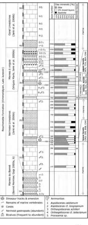
the visited excavations are located in the reuchenette Formation between the marnes du Banné (Banné member sensu Gygi, 2000a, b) and the marnes à virgula (Virgula member sensu lato of Gygi 2000a, b; northern Virgula marls in jank et al. 2006a; Virgula marls in jank et al. 2006b; lower Virgula member in colombié & rameil, 2007). in between, i.e. within the nerinean limestones defined by jank et al. (2006b), three emersive intervals, named lower (track) levels, intermediate (track) levels, and upper (track) levels reveal dinosaur tracks and testify prolonged peri-ods of emersion of the jura carbonate platform (Fig. 5).
the reuchenette Formation was originally defined by thalmann (1966). in the ajoie region it has a maximum thickness of more than
figure 4: General geological setting showing the position of the jura arc and the ajoie.
figure 5: Schematic figure of the
lithological succession of the reuchenette Formation between the marnes du Banné and the marnes à virgula. So far, three track-bearing intervals, named lower, intermediate, and upper levels have been identified in the tabular jura of the ajoie and are indicated in the right column. the abbreviations indicate which lev-els crop out at which tracksite, from bottom to top: cro = chevenez–combe ronde; crt =
c heve nez – cr at ; BeB =
courtedoux–Béchat Bovais; cHV = chevenez–la combe (quarry); Scr = courtedoux–Sur combe ronde; tcH = courtedoux– tchâfouè; BSy = courtedoux– Bois de Sylleux. the marnes à
virgula are located about 5 m
above the upper track levels. also indicated is the position of ammo-nites, and for selected layers the clay mineralogy, which was analyzed by j.-F. Deconinck (university of Dijon). From marty (2008).
f ig u re 6 : c hr on o-, b io - a nd li th os tr at ig ra ph ic al c on te xt o f t he K im m er id gi an r eu ch en et te F or m at io n a nd th e t hr ee tr ac k-be ar in g l ev el s o f t he d in os au r t ra ck -si te s in a jo ie , c an to n ju ra : te th ya n (s en su ga ll ic o) an d bo re al (s en su a ngl ic o) am m on it e zo na ti on s, se qu en ce bo un da ri es K im 3 to K im 4, an d m ax im um -fl oo di ng s ur fa ce ( m F ) a cc or di ng t o H an tz pe rg ue e t a l. ( 19 97 ) a nd H ar de nb ol e t a l. ( 19 98 ).
140 m (jank et al. 2006a). mineralo-stratigraphic, sequence-stratigraphic, and cyclostratigraphic studies carried out by mouchet (1998), colombié (2002), colombié & Strasser (2003, 2005), jank et al. (2006a, b, c), and Keller et al. (2006) in the Kimmeridgian and by rameil (2005) in the late Kimmeridgian and tithonian provide the lithostratigraphical frame and put forward a tethyan-to-Boreal correlation for the Kimmeridgian (jank et al. 2006a, c; colombié & rameil 2007). a cyclostratigraphical synthe-sis is given by Strasser (2007).
Since the excavations of the Palaeontology a16 started, many ammo-nites have been discovered establishing a well-defined biostratigraphical frame for the reuchenette Formation of northwestern Switzerland (Figs. 5, 6; jank et al. 2006a, b, c). the newly discovered ammonites place the inter-val between the marnes du Banné and the marnes à virgula between the late early Kimmeridgian and the early late Kimmeridgian (Figs. 5, 6).
During this fieldtrip we will visit the courtedoux–Bois de Sylleux site, where the marnes à virgula and the intermediate and upper track levels are excavated, and the courtedoux–Béchat Bovais tracksite, where the lower track-bearing levels are excavated.
Generally, the track-bearing levels can be described as a marly, platy limestone or biolaminite, even though the upper levels are much thinner and marlier than the lower and intermediate levels. Within the intermedi-ate levels, suggested to represent an elementary sequence of 20 kyr, dino-saur tracks have been found on at least 14 distinct surfaces suggesting the recurrent presence of dinosaurs in a supratidal flat to marsh environment (marty et al. 2006). Besides dinosaur tracks, invertebrate burrows (e.g.,
Thalassinoides), desiccation cracks, and ripple and wrinkle marks are
also commonly found, and can be observed during the fieldtrip.
the lower track levels are situated about 10 metres above the marnes du Banné and approximately at the boundary from the early and the late Kimmeridgian (Figs. 5, 6) that is somewhere in between the tethyan sequence boundaries Kim3 and Kim4 of Hardenbol et al. (1998). the sequence boundary Kim4 probably corresponds to the upper track levels, even though it was placed by colombié & rameil (2007: fig. 10) in the intermediate levels. assuming that Kim4 corresponds to the upper levels, the intermediate levels could be correlated with the laminated beds of the small-scale sequence 22 of colombié (2002: fig. 5.1) and of the small-scale sequence 52 of Strasser (2007: fig. 10).
the marnes à virgula can be interpreted as transgressive or and/or maximum flooding deposits of small-scale sequence 24 of colombié (2002) and small-scale sequence 54 of Strasser (2007). accordingly, a small-scale depositional sequence, corresponding to the 100 kyr
mylankovitch cycle (Strasser et al. 1999, 2006), can be postulated for the deposits between the upper track levels and the marnes à virgula.
4. Palaeogeographical, palaeoenvironmental
and palaeoclimatological setting
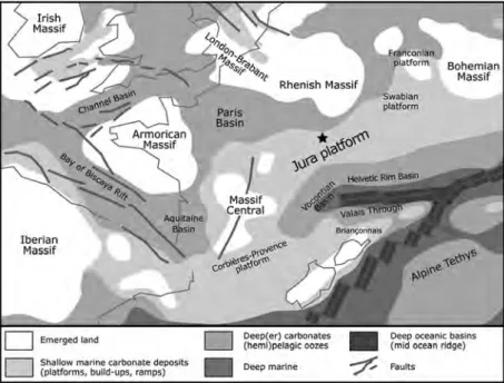
During the late jurassic, the original position of today’s jura mountains was located at the northern margin of the oceanic ligurian tethys (e.g., Gygi 1990; thierry et al. 2000; Stampfli & Borel 2002) as a large, struc-turally complex shallow carbonate platform (Fig. 7). this platform was at a palaeolatitude of around 30° n, at the threshold between the Paris Basin to the northwest and the tethys ocean to the south and thus, influ-enced by both the tethyan and Boreal realms (ziegler 1988; Dercourt et al. 1994; Smith et al. 1994; Dercourt et al. 2000; thierry 2000a, b).
During the late jurassic, the western tethys was already subjected to sinistral translative movements between africa and laurasia induced by northward propagation of the atlantic spreading axis. as a consequence of these movements, compressional stresses developed in the eastern parts of the tethys, whereas in the western parts sea-floor spreading diminished. Supported by accelerated rifting in the north atlantic, this led to a general thermal doming and associated sea-level fall, which caused widespread emergence (late Kimmerian unconformity) of the Hercynian-armorican, london-Brabant, central, rhenish, and Bohemian massifs (meyer & Schmidt-Kaler 1989; Dercourt et al. 2000; thierry 2000a, b).
the jura carbonate platform was subdivided into open lagoons, inter-nal lagoons, ooid shoals, reef barriers, tidal flats, supratidal flats and marshes, and land surfaces (e.g., colombié 2002; Hug 2003; colombié & Strasser 2005; marty 2005; jank et al. 2006a, c; rameil 2005; Védrine 2007; Védrine et al. 2007). lagoonal facies rich in carbonate-producing organisms, coral patch-reefs and ooid shoals testify to warm, subtropical waters. Water depths varied between a few tens of metres in the open lagoons to intertidal and supratidal along the coasts. controlled by syn-sedimentary tectonics, epicontinental basins developed mainly to the south of the platform (allenbach 2001; allenbach & Wetzel 2006). consequently, the Kimmeridgian of the ajoie is essentially made up of shallow marine carbonates and marls, in function of terrestrial input related to eustatic sea-level changes and climatic conditions.
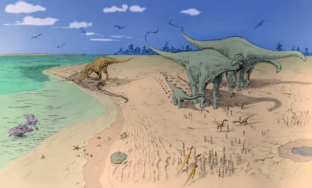
Small-scale sea-level drops repeatedly created vast emergent areas as is proven by the numerous dinosaur tracksites of the jura arc. Hence, dino-saurs habitually entered this coastal marine environment (Fig. 8) from the
london-figure 7: Palaeogeographic setting of the jura carbonate platform during the Kimmeridgian
(late jurassic, approximately 152 ma). after thierry et al. (2000a, b). the palaeogeographical position of corsica and Sardinia is interpreted differently in other reconstructions (e.g., Stampfli et al. 2002). asterisk marks the approximate position of the study area.
Brabant massif) in the northeast, or from the massif central in the south-west (meyer & lockley 1996; meyer et al. 2006).
During the Kimmeridgian, the climate of the jura carbonate platform was subtropical, and is generally considered semi-arid to arid (e.g., Hallam 1984, 1985; Frakes et al. 1992; moore et al. 1992; ross et al. 1992; moore & ross 1994; Weissert & mohr 1996; Bertling & insalaco 1998; Billon-Bruyat et al. 2005). Periodically, especially during oxfordian times, sil-iciclastics originating from the Bohemian and the central massifs were shed onto the platform and into the basins (e.g., Gygi & Persoz 1986; Pittet 1996), which implies generally more humid conditions. in the Kimmeridgian, siliciclastics are less abundant and evaporites occur, sug-gesting an evolution towards a generally more arid climate (colombié 2002; Hug 2003). this is also supported by the generally low content of kaolinite in the clay mineral fraction of the interval between the marnes du Banné and the marnes à virgula (Fig. 5).
on the jura carbonate platform, clays are often associated with the shallowest and/or early transgressive phase. this is explained by an
increased erosional potential in the hinterland following a rapid fall of relative sea level, possibly in combination with increased rainfall in the hinterland due to climatic changes depending on atmospheric circulation patterns (e.g., mouchet 1998; Strasser & Hillgärtner 1998; Strasser et al. 1999; Hug 2003). if the clay minerals were formed and/or eroded in the hinterland (i.e., in the rhenish massif and the london-Brabant massif to the n-nW, the Bohemian massif to the ne, or the massif central to the SW) they were transported from the parent rocks in the continental source area to the jura carbonate platform by water currents or by wind, as it has been suggested for the detrital quartz (e.g., Bolliger & Buri 1967, 1970; Gygi & Persoz 1986; Hug 2003). Since the increase in kaolinite is associ-ated with the most normal marine conditions and the highest generation in accommodation space, it is suggested that the kaolinite was reworked in the hinterland and not on the jura carbonate platform. However, Waite et al. (2009) recently postulated the existence of terra rossa-type soils on the platform as a possible source for kaolinite. another possibility is that immature palaeosols on the platform were a source for the mixed layer clay minerals and could explain the low kaolinite/illite ratio.
5. Dinosaur track excavations
Dinosaur bones of Cetiosauriscus greppini von Huene, 1927 were dis-covered already in the 19th century in the early Kimmeridgian of the
Basse montagne quarry, which is located near moutier, canton Berne
(Greppin 1870; von Huene 1922; Schwarz et al. 2007). However, the first dinosaur tracks were discovered only in 1989 in the lommiswil quarry near Solothurn (meyer 1990). this attested for the first time unequivo-cally the presence of larger and connected landmasses on the jura carbon-ate platform during the lcarbon-ate jurassic (meyer 1993). lockley & meyer (2000) stated that “the classic jura region is full of tracks that were previ-ously not known to exist”. indeed, since the initial track discovery in the lommiswil quarry, more than 20 tracksites have been discovered in the late jurassic of the Swiss jura mountains (review in meyer & thüring 2003), culminating in the discoveries in the ajoie (canton jura) along the transjurane highway (marty et al. 2007), and more recently also in the French part of the jura mountains near coisia (le loeuff et al. 2006) and loulle (mazin & Hantzpergue 2006).
consequently, dinosaur tracksites became useful not only regarding scientific research, but also regarding the high level of media and public interest and their great educational value. today, the tracksites of the jura mountains are generally considered as geotopes, or as important parts of the natural heritage (marty et al. 2004). accordingly, the larger sites are now in the focus of a more popular and touristic interest. For these rea-sons, the canton jura has allocated in august 2008 3.5 million Swiss Francs to the “Paléojura” project in order to valorize the dinosaur track-sites and the palaeontological heritage in general in terms of science, edu-cation, and tourism (www.palaeojura.ch/projetcantonal/f/).
on the future course of the transjurane highway, the courtedoux–Sur combe ronde tracksite was the first dinosaur tracksite discovered and excavated in 2002. marty et al. (2003) reported from the main track level 17 sauropod trackways, which they assigned to the ichnogenus
Parabrontopodus, and two tridactyl, bipedal trackways, attributed to
large theropods. the chevenez–combe ronde site was the second track-site discovered on the future course of a feeder road to the transjurane highway and is in the focus of the PhD thesis of marty (2008).
meanwhile, on the transjurane highway, dinosaur tracks were found and (partially) excavated on six extensive tracksites, in a nearby quarry in chevenez (associated with the construction of the highway), and also on several sites beside the transjurane highway due to cantonal prospect-ing (Fig. 3). these excavations resulted in several contiguous outcrops, and the so far excavated track-bearing surfaces sum up to more than 16’000 square metres.
the particularity of the transjurane tracksites is that they reveal tracks within three stratigraphic intervals (Fig. 5), and each of these intervals yields tracks on several superimposed levels. currently, tracks have been found on over thirty distinct levels. this resulted (by the end of 2008) in
figure 9: A: typical track (t16-r4) of the chevenez–combe ronde site attributed to
morpho-type i. B: outline drawing of Carmelopodus after lockley et al. (1998a: fig. 9, right track,
p. 264). c: Schematic outline drawing of t43-r2 of the combe ronde tracksite highlighting
the typical features of morphotype ii, which shares typical features of Therangospodus and
ornithopod ichnotaxa. D: outline drawing of Megalosauripus after lockley et al. (1998b: fig. 8,
lower right, p. 325); identification of digits after trackway shown in their figure 12d. modified from marty (2008).
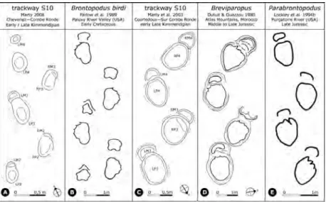
figure 10: comparison of trackway S10 from the main track level of the chevenez–combe
ronde site and trackway S10 from the main track level of the courtedoux–Sur combe ronde
site with other middle to late jurassic and early cretaceous sauropod ichnogenera. A:
trackway S10 from main track level of the chevenez–combe ronde site. B: redrawn after
Farlow et al. (1989: fig. 42.3, p. 374). c: redrawn after marty et al. (2003: fig. 5, p. 212). D:
redrawn after ishigaki (1989: fig. 9.5, p. 85). e: redrawn after lockley et al. (1986: fig. 7b,
the systematic excavation and documentation of dozens of ichnoassem-blages with a total of over 6400 dinosaur tracks including 177 trackways of sauropods and 234 trackways of bipedal dinosaurs. Because many tracks were located on superimposed levels and had to be destroyed by the ongoing excavations, dozens of casts were fabricated and considerable track-bearing surfaces were displaced and recovered, resulting in a large track collection actually stored in the repositories of the Palaeontology a16 in Porrentruy. additionally, the most important surfaces were also documented by laserscanning and photogrammetry. all this results in an important ichnological database and track collection, which is currently in a phase of organization and assessment by the Palaeontology a16.
all these excavated ichnoassemblages are referred to as “ajoie ich-noassemblages” (marty, 2008), which is characterized by the dominance of minute and small tridactyl tracks (Fig. 9a), tracks of medium-sized to large bipedal dinosaurs (Fig. 9c), and by tracks of tiny to large sauropods (Fig 10). Sauropod trackways are narrow-gauge (Fig. 10c) and (very) wide-gauge (Fig. 10a) possibly indicating the presence of the ichnogenera Parabrontopodus and Brontopodus (marty 2008), which are commonly attributed to basal and derived sauropods, respectively (Wilson & carrano 1999).
5.1 The Courtedoux–Bois de Sylleux tracksite
at “Bois de Sylleux”, track excavations started in the year 2004 and they will end in 2009. afterwards, the site is covered and partially destroyed by the construction of the transjurane highway and will not be accessible anymore.
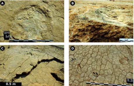
During the excursion, dinosaur tracks of sauropods and theropods (Fig. 12), ripple marks (Fig. 11c), desiccation cracks (Fig. 11D), microbial “build-ups”, and invertebrate burrows (e.g., Thalassinoides) will be vis-ible on different surfaces of the intermediate and upper track levels. the intermediate track levels are characterized by a pronounced biolaminated (stromatolithic) appearance and small, pustular microbial “build-ups” on the main track level (Fig. 11a).
So far, the excavations at “Bois de Sylleux” yielded remarkable discov-eries, such as tracks of small to medium-sized tridactyl, bipedal dinosaurs (probably theropods), of huge sauropods (up to 1.1 m pes length, Figs. 12a, B), of very large theropods (ca. 0.8 m pes length, Fig. 12a, D), and notably of tiny “baby” sauropods (around 10 cm pes length). the most important tracks were casted and/or extracted and are not visible in the field any-more, but casts of these tracks will be shown during the fieldtrip.
above the intermediate levels follows a 20-30 cm thick lag deposit with an accumulation of oysters at the base, and which is rich in marine
vertebrate remains and nautiloids, bivalves and large gastropods, and black pebbles. above the upper levels follows another lag deposit, which differs from the lower one because of the absence of nautiloids and black pebbles. However, intraclasts are in places abundant and may form breccias. Vertebrate remains and well-preserved bivalves and gastropods (including
Harpagodes oceani) are also common. Both lag deposits are characterized
by a high percentage of marine invertebrate and vertebrate macrofossils. this indicates some condensation and time-averaging (e.g., Fürsich 1978), which is typical after a rapid deepening following emersion, when carbon-ate production is still reduced because the carboncarbon-ate factory has to start up again (e.g., Kendall & Schlager 1981; Wright & Burgess 2005).
Between the lower and upper levels massif nerinean limestones with mass accumulations of nerineoidean gastropods can be observed. the macro and microfacies of the rocks with these nerineoidean assemblages suggest that their occurrence was related to water depth, physical energy within the habitat, sedimentation rate, substrate stability, and food supply. typical nerineoidean shells are high-spired and exhibit unique spiral
figure 11: courtedoux–Bois de Sylleux tracksite. A: Sauropod track (main track level)
modi-fied by the growth of pustular microbial mats. B: Displacement rim of a sauropod track in
cross-sectional view. internal overtracks to the right of the displacement rim can be explained
by repeated growth of smooth microbial mats within the track. c: level with bifurcated wave
ripples on the left and a surface with desiccation cracks just one level below on the right. D:
level with prism cracks and tridactyl tracks (coloured). Scale bars in a and D are 1 m, and 5 cm in B.
figure 12: Dinosaur tracks of the courtedoux–Bois de Sylleux tracksite. A: Photogrammetry (by
Perrinjaquet) of level 1050, october 2007: some of the large theropod tracks were extracted and casts will be shown during the excursion. note that tracks are coloured. Scale bar is approximately
5 m. B: Pes manus pair of a huge sauropod. level 1050, scale bar is 1 m (photograph by Patrick
Dumas / look at Sciences). c: multiple parallel trackways of small to medium-sized sauropods.
level 1040, diameter of tracks approximately 30 cm, picture taken at night. D:
Megalosauripus-like left track of a large theropod. track length is 35 cm, level 1035, trackway t3. note wrinkle
marks in the upper right, probably indicating the former presence of microbial mats.
laminae (folds) on the internal walls. mass accumulations consisting of large, heavy individuals are believed to represent a semi-sessile, suspen-sion-feeding community that utilized an external food source. During times of enhanced precipitation and run-off from the hinterland, terrestrial organic matter may have been supplied into the shallow sea, thus forming a source of food for the nerineoids. alternatively, relative sea level change during transgression may have led to large-scale coastal erosion and flood-ing of the platform, also potentially leadflood-ing to a mobilization of organic matter and clays. Size and morphology of the high-spired shells seem to indicate a trend towards maximal external volume. Development of folds within the shell is interpreted as a modification to maintain a small internal volume. the faunal and floral composition of the strata indicates a suspen-sion-rich, high-energy environment with a low sedimentation rate and a stable substrate. this allowed mass colonization by epifaunal nerineoids, which, in turn, formed a framework-like structure. the heavy shells acted as a grid, trapping the sediment in between. in this way, a reinforced car-bonate accumulation formed (Waite et al. 2008).
5.2 The Courtedoux–Béchat Bovais tracksite
With a total surface of more than 4000 m2 this is the largest tracksite
on the future highway course. excavations started in 2004 in the area that is now covered with the highway construction runway. Several trackways of medium-sized to large sauropods were found in that area crossing each other (Fig. 13a).
the surface that will be visited during the fieldtrip was uncovered from 2006 to 2008 and dinosaur tracks are currently visible on level 515 and on the main track level (level 500). in between the level 510 with well-developed desiccation cracks (Fig. 13D) and shallow undertracks stem-ming from level 515 can be observed. in the southern part of the tracksite, tridactyl tracks of minute to small bipedal dinosaurs, and tracks of tiny sauropods can be observed on the main track level.
over the largest surface of the site, however, level 515 is currently crop-ping out and will be documented in 2009 including laserscanning and photogrammetry. the particularity of level 515 is the presence of some very long (up to nearly 100 m) sauropod trackways running all over the site (Fig. 13B, c), and some of these show considerable changes in track-way configuration (e.g., gauge, change from pes-only to quadrupedal pat-terns, etc.) along their course, and also in track preservation due to lateral differences in sediment consistency.
For the fieldtrip, a platform and an illumination will be installed to observe the tracks at night.
5.3 Formation, taphonomy, and preservation of fossil
vertebrate tracks in biolaminites
Vertebrate tracks are at the interface of sedimentological, palaeonto-logical, and biomechanical research, because they result from the complex interaction of a foot with the substrate in a given environment (Padian & olsen 1984; unwin 1989). their study is a complex matter, and they can only be fully understood if they are analyzed using an interdisciplinary approach. after the “renaissance” of vertebrate ichnology (e.g. lockley 1987), considerable progress has been made during the last few years in experimental ichnology and neoichnology, and more attention has also been paid to the sedimentological analysis of fossil vertebrate tracks and track preservation (e.g., allen 1997; milàn 2006; milàn & Bromley 2006; Scott et al. 2007.
Vertebrate tracks should first be seen as deformed and lithified sedi-ment or as macrosedisedi-mentary structures, which offer a great potential for
sedimentological and palaeoenvironmental interpretations, as they can be seen as a palaeo-engineering test of the substrate (e.g., nadon 2001). notably the tracks of large vertebrates exert a heavy impact on the sub-strate of a given environment and at a given time. this impact leads to the formation of specific structures on the sediment surface (true tracks, over-all track) but also within the sediment underneath and around the track, for instance in the form of undertracks in laminated sediment or in the form of underprints and deep tracks in unlaminated, deep, and water-saturated sediment. the true track corresponds to the sediment surface that was in direct contact with the foot and the overall track encompasses the true track and all structures such as displacement rims, ejecta, or other extramorphological features associated with the true track (Fig. 14).
When a foot is put in a perfect way onto an ideal substrate, true tracks may exceptionally reveal the impression of the foot anatomy. only such tracks can readily be identified as unmodified true tracks and should be used for ichnotaxonomy and the identification of the trackmaker. unfortunately, such details are often not recorded because the trackmak-er’s feet aren’t suitable to leave such traces, or because the animal is too
figure 13: courtedoux–Béchat Bovais tracksite. A: crossroads of three sauropod trackways
on level 515. B: overview of level 515, which will be visible during the fieldtrip. note the
numerous trackways of medium-sized sauropod dinosaurs. the diameter of the pes tracks is
around 40 cm. in the background, the highway construction runway. c: close-up of the area
in the lower left of B: note the well-developed displacement rims indicating that the sediment
was moist to water-saturated at the time of track formation. D: level 510 with well-developed
figure 14: Schematical longitudinal sections through tracks explaining the terminology used:
displacement rim (dr), overall track (ovt), sediment fill (sf), tracked surface (ts), track wall (tw),
true track (tt), undertrack (ut). A: undertrack model showing the formation of undertracks
through the compression of laminated sediment by pressure of the foot. B: underprint model:
foot is breaking through the initial layering and the print is not left on the original sediment surface. When the sediment is split at a deeper level the overall track is less complete. With ongoing erosion the overall track is less complete and the true track modified, leading to the
formation of a modified true track (mtt). c: overtrack model and formation of internal
over-tracks (iot) and an overtrack layer (otl). D: in the track burial model the track is buried by rapid
heavy or too light to leave recognizable prints. moreover, ill-defined prints are created during running or jumping, because the soles are cov-ered with mud, because the substrate is too dry or too soft, or simply because weathering or erosion destroys the footprints (e.g., cohen et al. 1991; nadon 2001). moreover, this is further complicated in the fossil record where footprints undergo different stages of taphonomy and are at different stages within the diagenetic sequence of development. consequently, only a very small proportion of the tracks in a given area are capable of yielding diagnostic taxonomic information about the ani-mals that made them.
taphonomic processes acting on a track after its formation depend on sedimentary processes affecting the depositional environment. most exposed and consolidated vertebrate tracks are affected by taphonomic processes, which occur after their registration and lead to the formation of modified true tracks or weathered tracks. Destructive processes include vertebrate trampling, insect and other invertebrate bioturbation, root growth, weathering processes (heavy rainfall, wind deflation, desiccation with associated cracking and fracturing), deformation through displacive growth of evaporites, flooding and subsequent wave and seiche reworking or fluctuations of the groundwater table (e.g., Scott et al. 2007). these processes hinder footprint preservation or at least modify or obliterate the original true track, leaving behind a modified true track. Furthermore, accretion and erosion may occur on many time-scales and a track can repeatedly be partly filled by sediment, or partly or wholly emptied. thus, the rapid consolidation of a footprint is crucial to prevent obliteration and deformation prior to and/or during subsequent burial. this is possible by early cementation, rapid covering by sediment in association with major storms, and overgrowth by microbial mats.
on recent carbonate and siliciclastic tidal flats, a wide range of foot-print morphologies is produced by the same trackmaker due to differences in water content and nature of the substrate and the ubiquitous microbial mats. the growth parameters of the microbial mats are very facies spe-cific and can be linked to the environment, which can be expressed by the exposure index. microbial mats play an important role after footprint for-mation because they consolidate or lithify shortly after track forfor-mation and preserve a track, or because renewed and/or repeated growth of the microbial mat may modify a true track leading to the formation of modi-fied true tracks, internal overtracks, and overtracks. During periods of drought, the mats consolidate rapidly, getting hard and rigid and making it almost impossible even for a heavy trackmaker to leave a footprint. moreover, such consolidated microbial mats resist heavy rainfall and new footprints can only be made once a new microbial community is in place after renewed wetting. this narrows the time-frame during which
foot-figure 15: chevenez–combe ronde tracksite, excavation area 2: comparison of the excavated
levels 510 and 520. A: Superimposition of the maps (modified maps of the Palaeontology a16).
about half of the tracks of level 520 were not found on level 510. almost all tracks of level 510 were also found on level 520, and the congruity is very good. those tracks of level 510, which were not found on level 520 are probably undertracks from level 515, which was not excavated
in this area because it was amalgamated with layer 520. B: table showing the track dimensions
of measured tracks, occurring on both levels. note that almost all tracks of level 520 are clearly
smaller and deeper than those of level 510, which are comparatively larger and shallower. c:
level 520, track e27: deep track with a large and broad displacement rim (dr). D: level 510,
track e3 (same track as in c): shallow undertrack with a small and narrow, weakly-developed displacement rim. Scale bars in c and D are 20 cm, long and short axes are indicated. From marty (2008).
prints are registered and diminishes the time-averaging of an ichnocoe-nosis (marty et al. 2009).
these processes observed on recent tidal flats can be inferred from fos-sil tracks. this is facilitated by systematic level-by-level excavations of track-bearing intervals as well as by the analysis of the overlying and underlying layer in the case of a single track-bearing level. the level-by-level documentation of superposed surfaces enables to identify true tracks and to distinguish them from undertracks and overtracks, which is often not possible from a purely morphological point of view (Fig. 15). Generally, undertracks are increasingly worse defined, i.e., shallower (decrease in vertical topography), larger (increase in horizontal dimensions), and have narrower and smaller (weakly-developed) displacement rims than their corresponding true tracks (Fig. 15). overtracks are shallower but rather larger than their true counterparts. the internal outline is poorly defined and, if present, displacement rims are broader and flatter when compared with those of the true tracks (marty 2008). true tracks with displacement rims and undertracks without can be observed on the courtedoux–Béchat Bovais tracksite during the fieldtrip.
Poorly-defined tracks can be cut into serial sections to study the under-lying sediment (Fig. 16). this provides insight into the substrate
figure 16: chevenez–combe ronde tracksite, excavation area 3: cross-section of sauropod
pes track t16 of level 520. the track is clearly marked by the large, homogeneous displacement rim to the right, and the fractured and compacted zone underneath the homogenous track fill in the centre of the picture. in the middle of the track fill, “sk” points to a Skolithos-type bur-row. Faint undertracks without displacement rims are discernible on levels 515 and 510. layer 505 is unaffected by the track formation, either due to earlier consolidation or due to insuffi-cient track penetration depth. track penetration depth amounts to about 6-9 cm. layer 520 is compacted and completely thinned out in the middle of the print, in a way that an underprint is formed on top of layer 516. note the uplifted block of layer 515 in the middle part of the track, between the two thrust faults. layer 510 is less fractured but at the top significantly compacted, especially at the rear of the print. this may indicate that the sauropod put more weight on the posterior part of the foot than on the anterior part. Scale bar is 5 cm, from marty (2008).
properties at the time of track formation and into the kinematics of the trackmaker. a stack of undertracks indicates biolaminated sediment, whilst the absence of any undertracks may point to a thick and non-lam-inated sediment layer. the truncation of track structures by an unde-formed layer can be explained by consolidation of that layer prior to the formation of the track, which is important for reconstructing the consoli-dation history of the sediment. Finally, track morphology and associated track structures that resulted from taphonomic processes can be linked to the exposure index, making tracks useful in reconstructing the tidal-flat palaeoenviron ment.
6. Excavations in the marnes à virgula
these marls are up to 1 m thick (Fig. 17B), beige to dark-grey, glauco-nitic, oyster-rich (Nanogyra sp.). they could also be described as a
Nanogyra shellbed. the abundance of Nanogyra is poorly understood but
encrusted bivalves (e.g., Gervillia) and vertebrate remains indicate that they grew at least partially in situ (Fürsich & oschmann 1986a). this sug-gests that this shellbed is of biogenic origin, even though a sedimentologic origin (e.g., transport and accumulation by storms) cannot be excluded as well. a biogenic accumulation could have been favoured by an environ-ment with restricted conditions such as high bottom salinity or reduced oxygen, and the growth of Nanogyra could be related to “blooms” during periods of less hostile conditions. the general depositional setting is con-sidered a shallow subtidal, protected marine environment (jank et al. 2006a, c).
the marnes à virgula are subjected to systematic excavations (Fig. 17) because they yield a rich and diverse coastal marine assemblage of inver-tebrates (bivalves, gastropods, cephalopods, crustaceans, echinoids) but
figure 17: excavations in the marnes à virgula. A: excavation activity at courtedoux–
tchâfouè, where the marls are dark-grey. B: Section showing the thickness of the marnes à
virgula; a turtle carapace can be observed in the upper part of the marls. Scale bar is 50 cm
figure 18: Selected wood and vertebrate fossils from the marnes à virgula. A: Scr008-45,
branch of the fossil wood Protocupressinoxylon purbeckensis (conifera, cheirolepidiaceae)
from courtedoux–Sur combe ronde. B: tcH005-353, lower jaw (left, lingual view) of
Lepidotes sp. (osteichthyes, Semionotidae) from courtedoux–tchâfouè. c: BSy006-307,
artic-ulated plastron and carapace (ventral view) of Plesiochelys sp. (testudines, “Plesiochelyidae”) from courtedoux–Bois de Sylleux; the pelvis is preserved at the bottom part of the specimen.
D: tcH007-115, lower jaw of Steneosaurus sp. (crocodylia, teleosauridae) from courtedoux–
mainly of vertebrates (chondrichthyes, osteichthyes, turtles, crocodilians, pterosaurs), notably hundreds of remains of turtles, including more than forty carapaces of plesiochelyids (marty & Bruyat 2004; Billon-Bruyat, 2005a, b). in addition, these marls are very rich in fossil wood, with branched axes reaching up to 1.75 m in length. this wood has been identified as Protocupressinoxylon purbeckensis Francis, 1983 (Philippe et al. in press).
During the field-trip we will focus on excavation techniques (Fig. 17a) and show typical fossils of woods, fishes, turtles and crocodilians (Fig. 18).
7. Sedimentology below and above the marnes à virgula
a cleaned part of the hardground (marking the base of the marnes à
virgula) can be seen during the field-trip.
this well-developed hardground is, strongly encrusted by oysters and serpulids and perforated by Trypanites and Gastrochaenolites. on this hardground ammonites (Orthaspidoceras schilleri) and large infaunal bivalves (Ceratomya sp., Pholadomya sp.) in life position crop out. Both are encrusted and perforated, suggesting that the sediment was consoli-dated up to the level with the infaunal bivalves and since these are infau-nal bivalve, that the overlying sediment was eroded prior to the formation of the hardground. this goes in hand with the lack of pre-omission bur-rows. this hardground marks the base of the marnes à virgula, which corresponds to the base of the Eudoxus zone since Orthaspidoceras
schill-eri is not found in the marnes à virgula anymore (Fig. 5).
the hardground is situated at the top of a fossiliferous shellbed where it is possible to collect fossils, especially typical late jurassic inverte-brates (bivalves, gastropods, brachiopods, etc.) on site. Within this inver-tebrate shellbed below the hardground several rather poorly-developed hardgrounds have further been identified and are probably related to taphonomic feedback because of the high percentage of endobenthic invertebrate shells of the soft ground assemblage below (e.g., Kidwell & jablonski 1983; Kidwell & aigner 1985; Kidwell 1991, 1993).
in 2008, a disarticulated skeleton of a marine crocodilian was discov-ered in this hardground at courtedoux–Bois de Sylleux (Fig. 19). the skeleton is in preparation; at this time, it is composed of the major part of the skull and jaws, some isolated teeth, numerous vertebrae, some ribs and a femur. according to these elements, it is provisionally ascribed to the metriorhynchid genus Metriorhynchus meyer, 1830. this discovery adds a new taxon to the thalattosuchians discovered on the transjurane,
figure 19: BSy008-465, a disarticulated skeleton of Metriorhynchus sp. (crocodylia,
metriorhynchidae). Scale bar is 0.5 m.
along with the teleosaurids Steneosaurus, Machimosaurus and the metrio-rhynchid Dakosaurus.
on top of the marnes à virgula carbonate sedimentation starts again and several marly limestone beds are dominated by the shells of small oysters (probably Nanogyra) and can be described as densely-packed, bioclast-supported shellbeds with bioclast/bioclast contacts (sensu Kidwell & Holland 1991). Similar shellbeds with Nanogyra virgula have been interpreted as storm shellbeds by Fürsich & oschmann (1986b). in these layers the ammonite Aspidoceras caletanum was identified suggesting that the marnes à virgula correspond to the orthocera subzone of the
Eudoxus zone, because in the hardground located at the base of the marnes
à virgula, the ammonite Orthaspidoceras schilleri is frequently found (Figs. 5, 6).
about 5-10 m above the marnes à virgula clays are almost absent and carbonate deposition dominates again expressed by white, chalky lime-stones (coral limelime-stones of jank et al. 2006b) with abundant corals, interpreted as coral meadows, and invertebrates.
along the section below and above the marnes à virgula, different ben-thic macroinvertebrate associations (e.g., Fürsich 1976, 1977, 1981; Fürsich & Werner 1986; Werner 1986; oschmann 1988) and biostratinomic types (classifications in aigner 1985; Kidwell 1986; Kidwell et al. 1986; allison & Briggs 1991; Kidwell & Holland 1991; Fürsich 1995) can be observed.
references
aigner, t. 1985: Storm depositional systems: dynamic stratigraphy in modern and ancient shallow-marine sequences. Springer Verlag, Berlin new york Heidelberg, 174 pp.
allen, j.r.l. 1997: Subfossil mammalian tracks (Flandrian) in the Severn estuary, S.W. Britain: mechanics of formation, preservation and distribution. Philosophical transactions of the royal Society of london, Series B 352, 481-518.
allenbach, r., 2001, up with sea-level; down with differential subsidence – a new interpre-tation of the oxfordian of northern Switzerland. eclogae geologicae Helvetiae 94, 265-287.
allenbach, r.P. & Wetzel, a. 2006: Spatial patterns of mesozoic facies relationships and the age of the rhenish lineament: a compilation. international journal of earth Sciences 95, 803-813.
allison, P.a. & Briggs, D.e.G. 1991: taphonomy: releasing the data locked in the fossil record. Plenum Press, new york, 546 pp.
ayer, j., Hug, W.a., Becker, D., Billon-Bruyat, j.-P. & marty, D. 2005: les fouilles paléon-tologiques sur le futur tracé de la transjurane (autoroute a16): bilan provisoire et perspectives après 5 années d’activité. GeoForum aktuell 4, 30-35.
ayer, j., Becker, D., Billon-Bruyat, j.-P., Hug, W.a. & marty, D. 2006: ausgrabung und analyse von Fossilien der autobahn a16 (les fossiles de la transjurane (a16): de la fouille à l’interprétation). Schweizer Strahler (le cristallier Suisse) 4/2006, 10-18.
Bates, K.t., manning, P.l., Vila, B., Hodgetts, D., 2008a: three-dimensional modeling and analysis of dinosaur trackways. Palaeontology 51, 999-1010.
Bates, K.t., rarity, F., manning, P.l., Hodgetts, Vila, B., oms, o., Hodgetts, D., Vila, B., oms, o., Galobart, À. & Gawthorpe, r.l. 2008b: High-resolution liDar and photogrammetric survey of the Fumanya dinosaur tracksites (catalonia): implications for the conservation and interpretation of geological sites. journal of the Geological Society of london 165, 115-127.
Bertling, m. & insalaco, e. 1998: late jurassic coral/microbial reefs from the northern Paris Basin – Facies, palaeoecology and palaeobiogeography. Palaeogeography, Palaeoclimatology, Palaeoecology 139, 139-175.
Billon-Bruyat, j.-P. 2005a: First record of a non-pterodactyloid pterosaur (reptilia: archosauria) from Switzerland. eclogae geologicae Helvetiae 98, 313-317.
Billon-Bruyat, j.-P. 2005b: a turtle “cemetery” from the late jurassic of Switzerland. abstract, Swiss Geoscience meeting 2005, zürich, p. 238.
Billon-Bruyat, j.-P., lécuyer, c., martineau, F., j.-P. & mazin, j.-m. 2005: oxygen isotope compositions of latest jurassic vertebrate remains from lithographic limestones of western europe: implications on the ecology of fish, turtles and crocodiles. Palaeogeography, Palaeoclimatology, Palaeoecology 216, 359-375.
Bolliger, W. & Burri, P. 1967: Versuch einer zeitkorrelation zwischen Plattformkarbonaten und tiefmarinen Sedimenten mit Hilfe von Quarz-Feldspat-Schüttungen (mittlerer malm des Schweizer jura). eclogae geologicae Helvetiae 60, 491-507.
Bolliger, W. & Burri, P. 1970: Sedimentologie von Schelf-carbonaten und Beckenablagerungen im oxfordien des zentralen Schweizer jura. mit Beiträgen zur Stratigraphie und Ökologie. Beiträge zur Geologischen Karte der Schweiz, [n.F.] 140, 96 pp.
Braillard l. 2006a: rôles de la tectonique et de la stratigraphie dans la formation des val-lées sèches de l’ajoie. actes 2005 de la Société jurassienne d’emulation, 33-65.
Braillard l. 2006b: morphogenèse des vallées sèches du jura tabulaire d’ajoie (Suisse): rôle de la fracturation et étude des remplissages quaternaires. PhD thesis university of Fribourg, GeoFocus 14, 224 pp.
cohen, a., lockley, m.G., Halfpenny, j. & michel, e. 1991: modern vertebrate track tapho-nomy at lake manyara, tanzania. Palaios 6, 371-389.
colombié, c. 2002: Sédimentologie, stratigraphie séquentielle et cyclostratigraphie du Kimméridgien du jura suisse et du Bassin vocontien (France): relations plate-forme – bassin et facteurs déterminants. PhD thesis university of Fribourg, GeoFocus, 4, 198 pp.
colombié, c. & rameil, n. 2007: tethyan-to-boreal correlation in the Kimmeridgian using high-resolution sequence stratigraphy (Vocontian Basin, Swiss jura, Boulonnais, Dorset). international journal of earth Sciences 96, 567-591.
colombié, c. & Strasser, a. 2003: Depositional sequences in the Kimmeridgian of the Vocontian Basin (France) controlled by carbonate export from shallow-water platforms. Geobios 36, 675-683.
colombié, c. & Strasser, a. 2005: Facies, cycles, and controls on the evolution of a keep-up carbonate platform (Kimmeridgian, Swiss jura). Sedimentology 52, 1207-1227.
Dercourt, j., ricou, l.e. & Vrielynck, B. (eds.) 1993: atlas: Palaeoenvironmental maps, Paris, Gauthier-Villars, 307 pp.
Dercourt, j., Fourcade, e., cecca, F., azéma, j., enay, r., Bassoullet, j.-P. & cottereau, n. 1994: Palaeoenvironment of the jurassic system in the Western and central tethys (toarcian, callovian, Kimmeridgian, tithonian): an overview. Geobios, mS 17, 625-644.
Dercourt, j., Gaetani, m., Vrielynck, B., Barrire, e., Biju-Duval, B., Brunet, m.F., cadet, j.P., crasquin, S. & Sandulescu, m. (eds.) 2000: atlas Peri-tethys – Palaeogeographical maps. commission of the Geological map of the World, Paris.
Dutuit, j.-m. & ouazzou, a. 1980: Découverte d’une piste de dinosaure sauropode sur le site d’empreintes de Demnat (Haut-atlas marocain). mémoire de la Société géologique de France, nouvelle série 139, 95-102.
Farlow, j.o., Pittmann, j.-G. & Hawthorne, j.-m. 1989: Brontopodus birdi, lower creataceous sauropod footprints from the u.S. Gulf coastal plain. in: Gillette, D.D. & lockley, G.m. (eds.), Dinosaur tracks and traces, cambridge university Press, cambridge, 371-394.
Frakes, l.a., Francis, j.e. & Sykes, r.m. (eds.) 1992: climate modes of the Phanerozoic. cambridge university Press, cambridge, 274 pp.
Francis, j.e. 1983: the dominant conifer of the jurassic Purbeck Formation, england. Palaeontology 26, 277-294.
Fürsich, F.t. 1976: the use of macroinvertebrate associations in interpreting corallian (upper jurassic) environments. Palaeogeography, Palaeoclimatology, Palaeoecology 20, 235-256.
Fürsich, F.t. 1977: corallian (upper jurassic) marine benthic associations from england and normandy. Palaeontology 20, 337-385.
Fürsich, F.t. 1978: the influence of faunal condensation and mixing on the preservation of fossil benthic communities. lethaia 11, 243-250.
Fürsich, F.t. 1981: Salinity-controlled benthic associations from the upper jurassic of Portugal. lethaia 14, 203-223.
Fürsich, F.t. 1995: Shell concentrations. eclogae geologicae Helvetiae 88, 643-655. Fürsich, F.t. & oschmann, W. 1986a: autoecology of the upper jurassic oyster Nanogyra
virgula (DefRance). Paläontologische zeitschrift 60, 65-74.
Fürsich, F.t. & oschmann, W. 1986b: Storm shell beds of Nanogyra virgula in the upper jurassic of France. neues jahrbuch für Geologie und Paläontologie abhandlungen 172, 141-161.
Fürsich, F.t. & Palmer, t.j. 1975: open crustacean burrowers associated with hardgrounds in the jurassic of the cotswolds, england. Proceedings of the Geologists’ association 86, 171-181.
Fürsich, F.t. & Werner, W. 1986: Benthic associations and their environmental significance in the lusitanian Basin (upper jurassic, Portugal). neues jahrbuch für Geologie und Paläontologie abhandlungen 172, 271-329.
Giamboni, m., ustaszewski, K., Schmid, S.m., Schumacher, m.e. & Wetzel, a. 2004: Plio-Pleistocene transpressional reactivation of Paleozoic and Paleogene structures in the rhine-Bresse transform zone (northern Switzerland and eastern France). international journal of earth Sciences 93, 207-223.
Greppin, j.P. 1870: Description géologique du jura bernois et de quelques districts adja-cents. matériaux pour la carte géologique de la Suisse 8, 357 pp.
Gygi, r.a. 1990: Die Paläogeographie im oxfordium und frühesten Kimmeridgium in der nordschweiz. jahrbuch des Geologischen landesamt Baden-Württemberg 32, 207-222.
Gygi, r.a. 1995: Datierung von Seichtwassersedimenten des späten jura in der nordwestschweiz mit ammoniten. eclogae geologicae Helvetiae 88, 1-58.
Gygi, r.a. 2000a: integrated stratigraphy of the oxfordian and Kimmeridgian (late jurassic) in northern Switzerland and adjacent southern Germany. memoir of the Swiss academy of Sciences 104, 152 pp.
Gygi, r.a. 2000b: annotated index of lithostratigraphic units currently used in the upper jurassic of northern Switzerland. eclogae geologicae Helvetiae 93, 125-146.
Gygi, r.a. & Persoz, F. 1986: mineralostratigraphy, litho- and biostratigraphy combined in correlation of the oxfordian (late jurassic) formations of the Swiss jura range. eclogae geologicae Helvetiae 79, 385-454.
Gygi, r.a., coe, a.l. & Vail, P.r. 1998: Sequence stratigraphy of the oxfordian and Kimmeridgian stages (late jurassic) in northern Switzerland. in: de Graciansky, P.-c., Hardenbol, j., jacquin, t. & Vail, P.r. (eds.), mesozoic and cenozoic sequence stratigraphy of european basins, SePm (Society for Sedimentary Petrology) Special Publication 60, 527-544.
Hallam, a. 1984: continental humid and arid zones during the jurassic and cretaceous. Palaeogeography, Palaeoclimatology, Palaeoecology 47, 195-223.
Hallam, a. 1985: a review of mesozoic climates. journal of the Geological Society of london 142, 433-445.
Hantzpergue, P., atrops, F. & enay, r. 1997: Biozonations; Kimméridgien. in: cariou, e. & Hantzpergue, P. (eds.), Biostratigraphie du jurassique ouest-européen et méditerranéen, Bulletin des centres de recherches exploration-Production elf aquitaine, mémoire 17, 87-96 & 148-151.
Hardenbol, j., thierry, j., Farley, m.B., jacquin, t., de Graciansky, P.-c. & Vail, P.r. 1998: jurassic chronostratigraphy. in: de Graciansky, P.-c., Hardenbol, j., jacquin, t. & Vail, P.r.
(eds.), mesozoic and cenozoic sequence stratigraphy of european basins, SePm (Society for Sedimentary Petrology) Special Publication 60, chart.
Huene, F. von 1922: Über einen Sauropoden im oberen malm des Berner jura. eclogae geologicae Helvetiae 17, 80-94.
Huene, F. von 1927: Sichtung der Grundlagen der jetzigen Kenntnis der Sauropoden. eclogae geologicae Helvetiae 20, 444-470.
Hug, W.a. 2003: Sequenzielle Faziesentwicklung der Karbonatplattform des Schweizer jura im Späten oxford und frühesten Kimmeridge. PhD thesis university of Fribourg, GeoFocus 7, 156 pp.
Hug, W.a., Becker, D., marty, D. & oriet, a. 2004: la Section de paléontologie de la république et canton du jura: une brève présentation. actes de la Société jurassienne d’emulation 2003, 9-26.
Hurum, j.H., milàn, j., Hammer, o., midtkandal, i., amundsen, H. & Saether, B. 2006, tracking polar dinosaurs – new finds from the lower cretaceous of Svalbard. norwegian journal of Geology 397-402.
ishigaki, S. 1989: Footprints of swimming sauropods from morocco. in: Gillette, D.D. & lockley. m.G. (eds.), Dinosaur tracks and traces, cambridge university Press, cambridge, 83-88.
jank, m., meyer, c.a. & Wetzel, a. 2006a: late oxfordian to late Kimmeridgian carbon-ate deposits of nW Switzerland (Swiss jura): Stratigraphical and palaeogeographical implica-tions in the transition area between the Paris Basin and the tethys. Sedimentary Geology 138, 237-263.
jank, m., Wetzel, a. & meyer, c.a. 2006b: a calibrated composite section for the late jurassic reuchenette Formation in northwestern Switzerland (?oxfordian, Kimmeridgian
sensu gallico, ajoie-region). eclogae geologicae Helvetiae 99, 175-191.
jank, m., Wetzel, a., meyer, c.a., 2006c: late jurassic sea-level fluctuations in nW Switzerland (late oxfordian to late Kimmeridgian): closing the gap between the Boreal and tethyan realm in Western europe. Facies 52, 487-519.
Keller, c., Strasser, a. & marty, D. 2006: Palaeosurfaces as expressions of sea-level fall
and maximum flooding (late Kimmeridgian of the Swiss jura mountains). 14th annual
meet-ing of Swiss sedimentologists SwissSed, 28.01.2006, Fribourg, Switzerland, 20-21.
Kendall, c.G.St.c. & Schlager, W. 1981: carbonates and relative changes in sea-level. marine Geology 44, 181-212.
Kidwell, S.m. 1986: models for fossil concentrations: paleobiologic implications. Paleobiology 12, 6-24.
Kidwell, S.m. 1991: taphonomic feedback (live/dead interactions) in the genesis of bioclas-tic beds: keys to reconstructing sedimentary dynamics. in: einsele, G., ricken, W. & Seilacher, a. (eds.), cycles and events in Stratigraphy, Springer-Verlag, Berlin new york Heidelberg, 269-282.
Kidwell, S.m. 1993: taphonomic expressions of sediment- and hiatuses: field observations on bioclastic concentrations and sequence anatomy in low, moderate and high subsidence set-tings. international journal of earth Sciences 82, 189-202.
Kidwell, S.m. & aigner, t. 1985: Sedimentary dynamics of complex shell beds: implica-tions for ecologic and evolutionary patterns. in: Bayer, u. & Seilacher, a. (eds.), Sedimentary and evolutionary cycles. lecture notes in earth Sciences, Springer-Verlag, Berlin new york Heidelberg 1, 382-395.
Kidwell, S.m. & Holland, S.m. 1991: Field description of coarse bioclastic fabrics. Palaios 6, 426-434.
Kidwell, S.m. & jablonski, D. 1983: taphonomic feedback. Geological consequences of shell acumulation. in: tevesz, j.-S. & mc call, P.l. (eds.), Biotic interactions in recent and fossil benthic communities, Plenum Press, new york, 195-248.
Kidwell, S.m., Fürsich, F.-t. & aigner, t. 1986: conceptual framework for the analysis and classification of fossil concentrations. Palaios 1, 228-238.
laubscher, H.P. 1963 : Geologischer atlas der Schweiz. erläuterungen zum Blatt 1085 St-ursanne. Schweizerische Geologische Kommission, Bern, 26 pp.
le loeuff, j., Gourrat, c., landry, P., Hautier, l., liard, r., Souillat, c., Buffetaut, e. & enay, r. 2006: a late jurassic sauropod tracksite from southern jura (France). comptes rendus Palevol. 5, 705-709.
leica Geosystems 2003: Sensationelle Dinosaurier-Fussspuren mit 3D-lasermass. Vermessung, Photogrammetrie, Kulturtechnik 1/2003, 36-38.
lockley, m.G. 1987: Dinosaur tracks symposium signals a renaissance in vertebrate ichnol-ogy. Paleobiology 13, 246-252.
lockley, m.G. & matthews, n.a. 2007: observations on scientific documentation and preser-vation strategies employed at hominid and other vertebrate tracksites in america and elsewhere. in: Kim, j.y., Kim, K.S. (eds.), Proceedings of 2007 international Symposium on the conservation
and application of Hominid Footprints, 7th-9th December 2007, jeju island, japan, 13-43.
lockley, m.G. & meyer, c.a. 2000: Dinosaur tracks and other fossil footprints of europe, columbia university Press, new york, 321 pp.
lockley, m.G., Houck, K.j. & Prince, n.K. 1986: north america’s largest trackway site: implica-tions for morrison Formation paleoecology. Geological Society of america Bulletin 97, 1163-1176.
lockley, m.G., Farlow, j.o. & meyer, c.a. 1994: Brontopodus and Parabrontopodus ichnogen. nov. and the significance of wide- and narrow-gauge sauropod trackways. Gaia 10, 135-146.
lockley, m.G., Hunt, a., Paquette, m., Bilbey, S.-a. & Hamblin, a. 1998a: Dinosaur tracks from the carmel Formation, northeastern utah: implications for middle jurassic paleoecology. ichnos 5, 243-338.
lockley, m.G., meyer, c.a. & Santos, V.F. dos 1998b: Megalosauripus and the problematic concept of megalosaur footprints. Gaia 15, 313-337.
marty, D. 2005: Sedimentology and taphonomy of dinosaur track-bearing Plattenkalke
(Kimmeridgian, canton jura, Switzerland). 4th international Symposium on lithographic
lime-stone and Plattenkalk, 12-18.09.2005, eichstätt, Germany, zitteliana, B26, p. 20.
marty, D. 2008: Sedimentology, taphonomy, and ichnology of late jurassic dinosaur tracks from the jura carbonate platform (chevenez–combe ronde tracksite, nW Switzerland): insight into the tidal-flat palaeoenvironment and dinosaur diversity, locomotion, and palae-oecology. PhD thesis university of Fribourg, GeoFocus 21, 278 pp.
marty, D. & Hug, W.a. 2003: Das Dinosaurier-Spurenvorkommen von courtedoux, Kanton jura: Dauerhafter Geotopschutz und nachhaltige nutzung. In: jordan, P., Heinz, r., Heitzmann, P., Hipp, r. & imper, D. (eds.), Geotope – wie schützen / Geotope – wie nutzen, 7. internationale jahrestagung der Fachsektion Geotop der Deutschen Geologischen Gesellschaft und der arbeitsgruppe Geotope des Geoforums der Schweizerischen akademie der naturwissenschaften, Schriftenreihe der Deutschen Geologischen Gesellschaft 32, 115-121.
marty, D. & Billon-Bruyat, j.-P. 2004: a new reptilian fauna from the late jurassic of west-ern europe (Kimmeridgian, Switzerland). journal of Vertebrate Paleontology 24 (suppl. to no. 3), p. 90a.
marty, D., cavin, l., Hug, W.a., meyer, c.a., lockley, m.G. & iberg, a. 2003: Preliminary report on the courtedoux dinosaur tracksite from the Kimmeridgian of Switzerland. ichnos 10, 209-219.