De(con)struction / (re)construction :
urban scenography in Belgium in the 1960’s
Ph. D. Claudine Houbart
Is architect and art historian, has a master in conservation of monuments and sites and a PhD in engineering science. She is a professor at the Faculty of architecture of the University of Liège (Belgium) and a member of the research unit AAP (Art, Archèologie, Patrimoine), DIVA laboratory (Documentation, Interpretation, Valorisation of Architecture, Design and heritage). Her main research topics are history of conservation and urban renovation in the 20th century as well as conservation theory and philosophy.
Fecha de aceptación: 23 de noviembre de 2018 Fecha de disponibilidad en linea: 01 de enero de 2019
Abstract
In the decades following the second world war, the Belgian cities of Brussels and Liège, which didn’t suffer from any large-scale destruction during the conflict, are subjected to modernistic urban policies leading to the disappearance of whole sections of their traditional urban fabric. Helped by private agencies, cities’ administrations develop ambitious plans aiming to update their built environment and road system, in order to answer the needs of motorised traffic and modern lifestyle. This paper focuses on a practice developed in parallel to this prevailing tendency: under the direction of the city architects Jean Rombaux (Brussels) and Jean Francotte (Liège), some fragments of ancient buildings to be demolished are carefully dismantled and stored, with the aim of being reassembled in order to recreate fragments of idealised traditional townscapes. Through the examples of the Lombard-Violette and Saint-Georges blocks, respectively in the city centres of Brussels and Liège, this paper addresses the reasons behind the operations and the successive projects, and discusses the status of the results.
Keywords: relocated buildings, authenticity, urban renovation, façadism
Introduction
Since a few decades, the capital of Belgium has been the symbol of “a haphazard urban
development and redevelopment” (State, 2015, p. 79), at the expense of the human scale of its centre and the preservation of its heritage. This phenomenon, commonly called “brusselization”, has been quite widely studied (Romańczyk, 2012), and so have been some of the reactions it provoked in the late 1960’s (Doucet, 2015). The wide use of façadism from the 1970’s on, one of the consequences of the many destructions of the 1950’s and 1960’s and a superficial compromise accepted by some developers under the pressure of cultural associations, has also been the subject of important conferences and publications (Loyer & Schmulcke-Mollard, 2001). On the contrary, and despite its importance, the practice we would like to discuss in this paper didn’t catch much attention from the scholars, at least as far as Belgium is concerned1. At the very moment when the capital
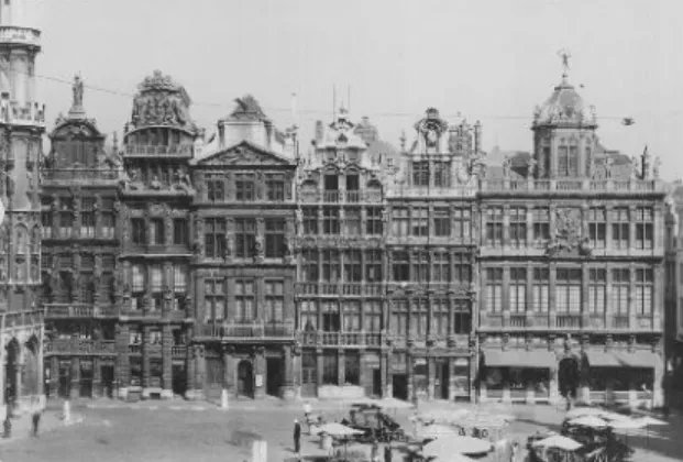
city was transformed, serving its heritage up to the supporters of an uncompromising modernism, a sort of “architectural reserve” is progressively constructed around the unanimously respected Grand’Place, theoretically dating back to the late 17th century but in practice heavily restored
at the end of the 19th century under the lead
of the “mayor-urbanist” Charles Buls (Figure 1). This zone is subjected to exceptional rules and practices aiming not only to preserve but also to enhance its historical aspect. The implantation and reconstruction of dismantled facades are one of the tools considered by the city administration to achieve this aim. Almost simultaneously, a similar practice is adopted in other Belgian cities hit by the same modernisation wave: in the case
1 The RWTH Aachen University is currently developing a research project about this practice in Germany, under the direction of
such as the groups “Alpha” or “Tekhné” (de Beule, Périlleux, Silverstre & Wauty, 2017), heritage is barely mentioned, and limited to main monuments and a few picturesque urban sites. Most of the buildings belonging to “minor architecture”, often in a very bad state of conservation, are to be demolished in the name of slum prevention. But not all of these buildings are simply demolished: for some of them, the main facade or some of its most important elements are dismantled and stored, waiting to be relocated. They are the subject of this short research.
Two different and sometimes complementary reasons lead to this practice. The first and most obvious is the recognition of an intrinsic value to the facade – dismantling whole buildings or interiors is almost never discussed. In that case, the building’s demolition is considered unfortunate, but necessary, and safeguarding the facade is a way to preserve its memory. Two cases are, for the period we consider in this paper, the Renaissance facade of the “Crossbowmen’s guild”, dismantled in the late 1950’s in order to build a modern school rue des Alexiens and the front and side facades of Victor Horta’s hotel Aubecq, demolished in 1950 to be replaced by a so-called “high class” apartment building (Figure 3). Already existing in the nineteenth century, this practice concerns important monumental of Liège, the creation of an “archaeological block”
is included from the start in one of the most destructive construction projects promoted by the municipality. The study of these two cases, on the basis of municipal archives, throw an interesting light on a popular but little-studied practice that questions today’s conservators.
Aside Brusselization: the “sacred block”
Detailing the gradual destruction of Brussel’s ancient urban fabric goes far beyond the scope of this paper, and would need to go back in history at least as soon as in the middle of the 19th
century. After the hygienist works of the mayor Jules Anspach, the “Haussmann from Brussels”, in the 1860’s and the ambitious vision of the “king-urbanist” Leopold II in the last decades of the century, we would need to mention the subterranean urban junction between the southern and northern railway stations, opened in 1952 after almost 50 years of intermittent works leading to the demolition of around 1200 houses (Jaumain, 2004) (Figure 2) and finally, the adaptations of the city in order to host the 1958 universal exhibition (Deligne & Jaumain, 2009). In the plans commissioned by the Ministry of Public Works and the City Administration from the 1940’s until the early 1960’s to private agencies
Figure 1 - View of the Grand’Place of Brussels in the early 1940’s (© Institut royal du Patrimoine artistique (hereafter IRPA), b031491).
Figure 2 - The Putterie district seen from the tower of Brussels’ city hall in 1912. Part of the area has already been demolished for the construction of the railway junction (© IRPA, a102953).
buildings and often leads to unachieved projects : both examples we mentioned are still unresolved, despite the fact that the facades in question appear in many projects through time (Figure 4)2.
The second reason is not linked in the first place to the qualities of the dismantled structure, but rather to its potential to enhance the cityscape, and goes hand in hand with the “sacred block” policy, launched in the early 1960’s under the pressure of conservative circles, lead by the “Aesthetic league”.
Founded in 1953 on the basis of the “Aesthetic commission of the Christian Social Party”, the Aesthetic league, originally mainly composed of members of the aristocracy and upper-middle-class, has the stated goal of “fighting the aesthetic decadence” of the century, considered as a threat to civilisation3. The safeguard of monuments and
sites is one way to achieve this goal. Linked to the most powerful political party of the moment at the scale of the country, the association plays an active role in the questioning of modernist projects mostly in the capital but also elsewhere in Belgium, and strongly supports the creation, in 1956, of a “sacred blocks commission” by
the liberal mayor Lucien Cooremans. Composed of council civil servants, the city architect and archivist, historians, university professors and museum curators, the commission is in charge of finding solutions to the disappearance of the “ancient and traditional character” of some important districts of the city. The works of this commission lead to the drafting, in 1959, of a district plan (plan particulier d’aménagement) for one of these areas, around the Grand’Place, renamed the “sacred block” (îlot sacré). The plan is focused on the aspect of the public spaces: only streets, squares and facades are subjected to regulations without taking into account the internal structures of the blocks and buildings (Figure 5).
In order to “conserve or give back to public spaces of the perimeter their ancient and folkloric character” – that is, the character they ideally had when they were rebuilt after the bombing by the French army in 1695 –, the plan distinguishes four types of facades. The first, figured in red on the plan, “must be conserved and restored on the basis of original elements found in situ or in the archives”. The second “have to be built in
2 The dismantled facade of Horta’s hotel Aubecq, after having been moved several times, has been the object of an “anastylosis
on the ground” for an exhibition only a few years ago, but is still waiting to be reused (Conde-Reis, 2011).
3 Projet de statuts, sd, Ligue esthétique belge, box G, Brussels City Archives.
Figure 3 - Victor Horta’s hôtel Aubecq’s facade reconstructed on the ground for an exhibition in 2011 (Picture by the author, 2011).
Figure 4 - Model of a renovation project for the Sainte-Anne district in Brussels by Raymond M. Lemaire in 1970. The facade of the “crossbowmen guild”, with arcades on the ground floor, is used to create a new square in the middle of the block (KULeuven, University Archives, Raymond M. Lemaire Collection)
buildings, a historically dubious but visually coherent ensemble, funded by the city budgets. In order to compensate the economic prejudice caused by the limitation of the facades’ height, the regulations allow to build deeper on the plots, to the detriment of courtyards and gardens: appearance is more important than liveability (Figure 6).
The triangular Lombard-Violette block is situated in the southern part of the perimeter (Figure 7):
Figure 5 - Regulation plan for the “sacred block” in Brussels, version revised in 1968 (Brussels, Urbanism Department Archives).
only to be limited in height (blue). With these prescriptions, the plan aims to recreate bit by bit, for mainly touristic reasons, at the occasion of transformations or reconstruction of isolated
Figure 6 - Aerial view of the Grand’Place of Brussels and its surroundings in 1971, showing the filling of the “traditional” building blocks with modern constructions (© Bruciel 2018).
Figure 7 - Situation plan of the Lombard-Violette block, 1964 (Brussels City Archive (hereafter AVB), TP77673).
Figure 8 - Perspective of the eastern half of the Lombard-Violette block, showing its particular morphology (AVB, TP90008).
whereas the rue du Lombard, a broad street created at the beginning of the 20th century,
borders the block to the south, the rue de la
Violette and rue de l’Étuve, much older, mark
its limits to the north-west and north-east. This particular situation of the block, cut in two by the
rue des Chapeliers, explain its unconventional
morphology, with the back of the rue du Lombard’s eight-storey buildings dominating the traditional silhouettes of the rue de la Violette’s houses, especially when seen from the portion of the rue
des Chapeliers leading to the Grand’Place (Figure 8). Already heavily transformed in the 19th century,
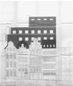
these houses are mentioned in yellow on the plan, meaning that they should be rebuilt using the “right style”. In 1962-1963, the city architect, Jean Rombaux, drafts a project for these houses, caught between the tall angle building marking the prow of the block to the east, and to the west, a seven-storey office building constructed in the 1950’s to host a construction firm.
The row of house studied by Jean Rombaux, interrupted by the rue des Chapeliers, comprises eleven houses, and even if most of them originally date back to the 17th and 18th centuries, only a few
interesting architectural features are conserved,
Figure 9 - View of the houses rue de la Violette in 1975 (© IRPA, T017565).
or at least, remain visible. Indeed, whereas the ideal local houses from this period should present bricks and stone facades with elaborate windows, crown by decorated gables and dormers, the actual houses are much less fancy, with a worn whitish rendering, horizontal cornices and simple rectangular windows, an aspect resulting from the lack of maintenance linked to the impoverishment of the city centre since the 19th century (Figure 9).
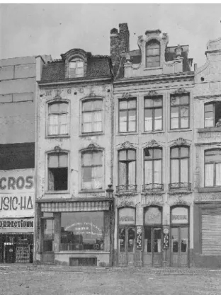
In application of the newly adopted regulation, the plan drawn by the city architect is an attempt to restore them to their former splendour. The before-and-after plans kept in the archive reveal three types of interventions: a thorough restoration of the only two houses still retaining a gable (removal of the facade rendering, restoration of the window frames, reconstitution of decorative details and shop fronts); the demolition and reconstruction “in style” of seven facades (most of them crown with gables, the others with dormers) and finally, the replacement of two others by the integration of facades dismantled in other areas. To complete the alignment, the rue des Chapeliers is visually closed by a construction in style integrating a displaced monumental doorway (Figure 10 & 11). Integrating dismantled facades coming from demolished parts of streets or blocks is a common intention around 1960 in Brussels, and the architecture department of the city administration has a large depot, situated on
Figure 11 - Restoration project of the houses rue de la Violette by Jean Rombaux, planned state,1963 (AVB, ARCH389).
Figure 12 - House n°10, rue de la Steenpoort, ca 1760, demolished in 1956-1957, to be relocated rue de la Violette, n° 31 (© IRPA, a068385)
the styles of the 17th and 18th centuries” (yellow),
while the third adopt a modern style with “a rhythm and a composition in harmony with those of the traditional architecture of this period”. Finally, the fourth, at the limits of the area, are
Figure 13 - On the right, house n°48, rue du Marché aux Poulets, 16th-18th centuries, transformed 20th century, demolished around 1960, to be relocated rue de la Violette, n°27 (© IRPA, a075190).
Figure 14 - Monumental doorway by Jacques II Franquart, probably 1625-1628, rue d’Isabelle, dismantled beginning of the 20th century, to be relocated at the entrance of rue des Chapeliers (© IRPA, a104104).
the site of a former gas plant in Laeken, to store them while waiting for their reuse. In our case, Jean Rombaux plans to use architectural elements coming from there different places and belonging to three different styles. The first one, built in 1760, and disassembled in 1956-1957 in the context of the railway junction works, is a two-storey Louis XV facade, with a horizontal cornice and a curved dormer (Figure 12); to fit its new plot, it is slightly extended on both sides of the outer windows. The second facade is more monumental: originally built in the 16th century on
the rue du Marché aux poulets, and transformed in the late 17th, it becomes the entrance of a
cinema in the 20th century, a function that leads
to further transformations, especially on the ground level (Figure 13). After a fired devastates the complex in 1957, the cinema is demolished and replaced by a shopping mall built by the
modernist architect Jacques Cuisinier. To take place in the alignment of the rue de la Violette, the dismantled facade is provided with a new ground level “in style”, for which Jean Rombaux provides two alternatives, each one modifying the overall height of the house. The last integrated element is a monumental doorway, designed by the architect Jacques II Franquart around 1625, and formerly the entrance of the Crossbowmen’s guild garden (Figure 14), on the rue d’Isabelle, a street that had disappeared in the beginning of the 20th century
in the remodelling of the Putterie district. Thus contrary to the two previous facades, this door had been dismantled nearly half a century before its integration in the project. It is included in the new facade in an incomplete state, dating back to the dismantling of its upper part for security reasons in 1880, when its architectural value wasn’t unanimously recognised by the experts.
Simon Brigode, collaborating for the occasion with the modernist architect Marcel Lambrichts, extends the existing office building on four plots to the east, behind a thin layer of traditional decor. According to the plans, the four facades covering the new extension on the rue de la Violette are, from the left to the right, a restored existing house, the two displaced houses also present
about the upper part of the 17th-century facade
theoretically coming from the rue du Marché aux poulets, but here, the lower levels are a completely fanciful interpretation of the existing, replacing pilasters by columns and inventing a superposition of orders that has never existed before. In consequence, the houses used as a superficial camouflage of the modern extension,
Figure 15 - Extension of office buildings rue de la Violette, project by Marcel Lambrichs, 1967 (AVB, ARCH325).
Jean Rombaux also provides two alternatives for the facade in which it is included.
Rombaux’ project isn’t realised as such. In 1963, the construction firm already present in the lower part of the block asks a building permission to extend its buildings on the whole site. Leading to the demolition of the whole fabric, the project is rejected in the name of the “sacred block” régulation. After this rejection, several compromises are sought, and the regulations are even revised in order to allow the construction of the office building, provided that it is set back behind the aligned “restored” ensemble conceived by Rombaux (Figure 15). For many reasons, not all linked to heritage, this project is only partially realised, in a modified version, on the lower part of the block until the rue de
Chapeliers. This reduced version, endorsed by
the architect-conservator and university professor
in Rombaux’ project, and a new composition based on traditional proportions, making the transition between these houses and the existing modernistic office building (Figure 16). But a careful look at the plans, completed with a study of the archives reveals that the only house to be restored had, in fact, to be completely demolished and rebuilt, due to the heavy deterioration of its structure. Comparing the two houses theoretically relocated on the site with pictures of the same houses before disassembly and Jean Rombaux’ drawings is even more interesting. Presented as reconstructions of dismantled buildings – the archives reveal that at least one of them had been sold by the city administration to the construction company ordering the works – they are in fact only approximate copies of these buildings. As to the Louis XV house, the proportions are respected, but the stones are visibly new and the details, repetitive and simplified. The same can be said
are themselves nothing but a fake testimony of heritage reuse (Figure 17).
From Brussels to Liège : an “archaeological block”
Capital of a large episcopal principality from the 10th until the end of the 18th century, the city of
Liège, in the eastern part of Belgium along the Meuse river, reaches the contemporary period with a rich heritage, despite the successive destructions of the city by Charles le Téméraire (1468) and the French army (1691), not to mention the destruction of the cathedral in 1789. But in the course of the 19th and 20th centuries,
this heritage suffers the consequences of the city modernisation and, more particularly for Liège, of the industrial booming of the region. After the large-scale sanitation works carried on under the lead of the engineer Hubert-Guillaume Blonden in the course of the 19th century, leading to the
filling of some arms of the river and the creation or broadening of many streets, the city hosts two large scale international exhibitions that lead to further modernisations, respectively in 1905 and 1939 (Renardy, 2005). But the heaviest disruptions occur, just like in Brussels, after the second world war, especially through the actions of the association “Le Grand Liège” and one of its directors and city alderman, Jean Lejeune. Founded in 1937, the association “Le Grand Liège” is an important actor of the city recovery after the second world war. Besides the restoration of the war damages, the association promotes a modernistic vision of the city development that Jean Lejeune, city alderman in charge of public works between 1959 and 1976, strongly contributes to implementing, with heavy consequences for the pre-industrial urban heritage. In order to connect the city to the newly conceived national highway network, to ease the traffic flow through the city and to modernise housing and public facilities, large portions of the ancient fabric are erased. Again, developing the ins and outs of these policies would move us away from the subject of this paper, and we will concentrate on one of the many projects promoted by Lejeune. This project, for the Saint-Georges district, is particularly interesting for this paper because of its two complementary parts: the construction of a modern multifunctional complex on the one hand, and the creation of what Lejeune
Figure 16 - Extension of office buildings rue de la Violette, project by Marcel Lambrichs & Simon Brigode, 1974 (AVB, TP86058).
Figure 17 - View of the houses n°21-25, rue de la Violette (Picture by the author, 2018).
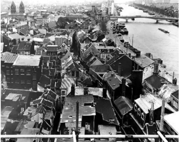
composed of the cathedral, the prince-bishop’s palace and the market square. Initially outside the walls of the city, the district is structured around three parallel streets amongst which one of the historic wharves. Until the 1960’s, the overall urban fabric, composed of a quite compact ensemble of traditional houses, with a few larger private mansions and churches, is preserved but most building blocks are saturated and unsanitary (Figure 18). Limited by the Feronstrée to the north, the Quai de la Batte to the south, and the
Saint-Jean-Baptiste and Saint-Georges streets to the
west and east, the so-called Saint-Georges block also comprises a network of narrow streets and dead ends, among which the rue Sur les Foulons. The replacement of a complete block by a modern facility mostly financed by the private sector is not a first in the area. In the early 1960’s, Jean Lejeune had already launched a similar operation on the neighbouring block, replacing the existing streets and buildings by a tower hosting the city administration, a shopping mall and a parking, an ensemble conceived by the modernist architects Jean Poskin and Henri Bonhomme (Figure 19). To pacify the opponents of the project, a few facades had already been disassembled and carefully stored in a city warehouse (Figure 20). The “renovation” of the Saint-Georges block is himself calls an “archaeological block”, on the
basis of displaced facades, on the other hand. These two faces of the same project correspond to the two faces of the alderman himself: besides being a liberal politician striving, by all means, to turn Liège into an international metropolis, Jean Lejeune is also a respected historian, teaching at the University of Liège, and author of many books on the principality’s history and culture.
The Saint-Georges block is situated in the so-called Hors-Chateau district, on the southern bank of the Meuse river and west of the core of the city
Figure 18 - View of the Saint-Georges district from the scaffoldings of the new administrative centre, ca 1965 (CRMSF).
Figure 19 - View of the Quai de la Batte, the new administrative complex is in the centre-left of the image. the last building on the right will be relocated in the “archaeological block” (© IRPA, M043382)
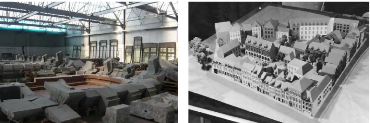
Figure 20 - View of warehouse where the dismantled facades are stored, waiting to be relocated (CRMSF)
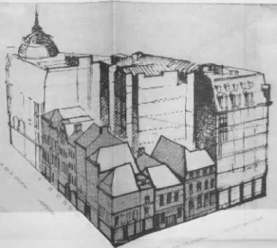
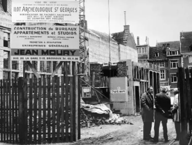
decided straight after, in 1965, leading to further demolition works which start in 1970. The 123 existing buildings on the site, among which 115 had been officially qualified of slums, disappear in order to leave room for another modern ensemble designed by the same architects. Contrary to the former project, the operation foresees, from the start, the creation of an “archaeological block” where the dismantled facades are to be rebuilt. It is situated west of the block on the other side of the broadened Saint-Georges street, around a monumental private mansion, the hôtel Somzé, used by the city administration. The ensemble, in L-shape, extends to the rue Sur les Foulons, replacing a few “uninteresting slums” (Figures 21-22).
The reconstruction of these facades, “listed as monuments or particularly representative of the 17th and 18th centuries architecture in Liège”, is
presented by Jean Lejeune as a solution advised by the Royal Commission of Monuments and Sites, an advisory body of the Ministry of Culture. But it also clearly reflects the two faces of the alderman. The city architect Jean Francotte is put in charge of the survey and documentation of the facades, as well as of their harmonious relocation and assemblage. The archive keeps a very detailed photographic survey of all stages of the operation
(Figure 23).
Figure 22 - Plan of the Saint-Georges district, from Jean Lejeune, Rénovation du quartier Saint-Georges, 1969. In red: streets and dead-ends to be suppressed; in yellow: streets broadenings; blue: built plots. The “archaeological block” is in the upper right part pf the drawing, next to the Hôtel Somzé.
Figure 21 - View of the model representing, from left to right: the administrative centre, the Saint-Georges complex and the “archaeological block” (CRMSF).
Figure 23 - The “archaeological block” under construction, ca 1975 (CRMSF)
Figure 24 - Jean Francotte, first draft of the elevation of the “archaeological block” on the rue Saint-Georges, from Jean Lejeune, Rénovation du quartier Saint-Georges, 1969.
architectural details and materials (bricks and stones in various proportions, half-timbering) lead to a very picturesque overall image (Figure 24). Comparing the buildings as represented on Francotte’s drawings with pictures of the same buildings before displacement reveal different attitudes towards, on the one hand, the single facades, and on the other hand, the two buildings used for the angles. As to the first, the drawings respect the composition of the existing facades, A first version of the ensemble, comprising facades
coming from ten different buildings, is presented in a report by Jean Lejeune on the overall project in 1969. It makes use of eight recuperated front facades, half of them coming from the Feronstrée, half from the rue sur les Foulons, and dating back to the 17th, 18th and early 19th centuries.
With each facade presenting different stylistic features, the ensemble is characterised by a great diversity, emphasised by the treatment of its angles. On the corners of the rue Saint-Georges
Figure 25 - House n°76, En Feronstrée, 1741-1760, demolished ca 1970 and relocated in the “archaeological block” (© IRPA, A017136).
Figure 26 - House at the corner of Quai de la Batte with rue Saint-Jean-Baptiste, 17th century, demolished around 1970 and relocated in the “archaeological block” (© IRPA, A017033)
with the Feronstrée and rue sur les Foulons, the architect proposes to reconstruct what seems to be two entire buildings: a large 17th century
brick and stone house, formerly at the angle of the rue Saint-Jean-Baptiste with the wharf, and a mostly half-timbered coaching inn, also formerly rue Saint-Jean-Baptiste. The diversity of scales,
except for the ground floors when they had been transformed through time. In that case, the architect drafts a new composition in style (Figure 25). Some punctual elements are restored, such as the windows mullions and transoms when there is evidence of their former presence. The treatment of the angle buildings is different and
the search of a satisfying solution seems to justify the existence of three successive versions of the project.
In each of the three versions, the angle of the rue
Saint-Georges with the Feronstrée is marked by
the most monumental building of the ensemble. In the first two versions, the facade of its half-timbered annexe is reused as well. Comparing the ancient pictures of the main building with the drawings clearly shows that the three existing facades are combined in order to compose the two facades of the building in the project. This allows not only to fill the gaps resulting from gradual transformations but also, to make use of all existing distinctive elements (the dormers for example) (Figure 26). But as a result, none of the reconstructed facades of this building corresponds to the actual composition before displacement, and the ensemble looks more like an idealised version of its model. It is even more the case for the other corner of the ensemble, a brand new assemblage of facades coming from a 17th-century coaching inn on the rue
Saint-Jean-Baptiste, restored in the mid-1950’s before
being condemned by the modern project. On its former plot, the ensemble was composed of a narrow house with a carriage gate, leading to a small courtyard at the back surrounded with
half-timbering buildings (Figure 27). In the new composition, the facades are assembled in order to create a building in L-shape, combining the front facade in brick and stone with two of the courtyard facades, including a picturesque stairway turret. In this case, the configuration of each facade is respected, but the shape of the building is completely different. In the two next versions, this building, which is finally included in another group composed of restored and displaced buildings on the slope of the hill nearby, is replaced by 3-storey monumental facade coming from the Feronstrée on the rue Saint-Georges, while the lateral facade on the rue Sur le Foulons is a plain brick wall with rows of windows with curved lintels, alien to the original building (Figure 28).
Conclusion: a valueless heritage?
In a 2008 paper, Jenny Gregory questioned the authenticity of relocated buildings. After reviewing the different international documents adopted by ICOMOS since the Venice charter, she observed that “in summary, [they] reject relocation except in situations of last resort where relocation is essential to safeguard, or to conserve, restore or preserve, or to comply with national or international interests” (Gregory, 2008, p. 114). Both operations we discussed in this paper were
Figure 27 - View of rue Saint-Jean-Baptiste in 1964, during the construction of the administrative centre. The outside facade of the coaching inn is at the centre of the image (© IRPA, M103543)
planned in the years following the adoption of Venice charter. Neither Jean Rombaux, nor Jean Francotte were present at the Venice congress, but Simon Brigode, who took over the Lombard-Violette project, and Nicolas Leclercq, who collaborated with Jean Francotte in Liège for the reconstruction of the 17th-century coaching inn in
its definitive location, were there. Nevertheless, both operations are in strong contradiction with the restoration principles and limits stated by the document : not only the buildings are relocated, but they are only relocated partially and not always in compliance with their original compositions and shapes. As to the materials, the operation in Liège makes use of mostly original stones and timbers for the facades, new pieces being limited to recreated parts and missing elements. But, with the only exception of the corner house on the
Feronstrée side, where the whole framework is
reused, the internal structures of the houses are completely new and built in reinforced concrete (Figure 29). In consequence, when looked at as 17th
or 18th century houses, the buildings composing
the ensembles both in Liège and Brussels are at best, incomplete and falsified testimonies of how the facades were designed, and at worst, for some of them, authentic fakes, “restored not to how they used to look, but to how (city planners imagine) tourists want them to look” (Glenn, 2006 quoted by Gregory, 2008, p. 125). That is
the case, for example, of the two houses rue de
la Violette in Brussels, but they are far from being
exceptional.
Does this make these ensembles a sort of valueless or even, embarrassing heritage? Putting them to the test of the proofs proposed by the Declaration of San Antonio to assess heritage authenticity suggests that it is indeed the case (ICOMOS, 1996). The displaced houses don’t “remain in the condition of [their] creation”, and don’t “reflect all [their] significant history”. They are fragmented, and the recent additions are many. The context has changed, there is no community identifying itself to the site and finally, the use patterns are completely different. The fact that none of these building is currently protected as a monument is consistent with this analysis but at the same time, seems contradictory with the important means devoted to the dismantling of the facades, their storage and finally, their rebuilding. The only way to overcome these contradictions is to look at these ensembles from another point of view. Despite their differences, both projects we discussed in this paper are authentic testimonies of one and a same reality: the local authorities’ uneasiness towards urban renovation at the very moment of the shift from modernist to postmodernist approach to the historic city (Figure 30). As such, they might need to be looked
Figure 30 - Jean Lejeune at the foundation stone ceremony of the “archaeological block” (CRMSF)
Figure 29 - Detail of the archaeological block under construction (CRMSF)
at, not as more or less truthful reconstructions, but as constructions truly embodying a somehow repressed but genuine aspect of the spirit of their time, a very particular moment in the history of cities. And as such, they are an authentic heritage from the 20th century.
References
de Beule, M., Périlleux, B. Silvestre, M. & Wauty, E (Eds) (2017). Bruxelles. Histoire de planifier.
Brussels: Mardaga.
Conde-Reis, G. (ED.) (2011). Victor Horta. Hôtel
Aubecq. Brussels: Direction des monuments et
des sites.
Deligne, C, Jaumain, S. (Eds) (2009). L’expo 58:
un tournant dans l’histoire de Bruxelles. Brussels:
Le Cri.
Doucet, I. (2015). The Practice Turn in Architecture:
Brussels after 1968. New-York: Ashgate.
Glenn, J. (2006). Fake Authenticity: An Introduction. Hermenaut, 15.
Gregory, J. (2008) Reconsidering Relocated Buildings: ICOMOS, Authenticity and Mass Relocation, International Journal of Heritage
Studies, 14 (2), 112-130.
ICOMOS (1996). Declaration of San Antonio. Jaumain, S. (Ed.) (2004). Bruxelles et la jonction
Nord-Midi. Histoire, architecture et mobilité urbaine. Brussels : Archives de la Ville de Bruxelles.
Loyer, F., Schmulcke-Mollard, C. (2001) (Eds.).
Façadism and Urban Identity. Paris: Editions du
Patrimoine.
Renardy, C. (2005). Liège et l’exposition
universelle de 1905. Antwerp: Fonds Mercator.
Romańczyk, K. M. (2012). Transforming Brussels into an international city – Reflections on ‘Brusselization’. Cities, 29 (2), 126-132.
State, P. F. (2015). Historical Dictionary of Brussels. Lanham, Maryland : Rowman & Littlefield.