HAL Id: insu-01665860
https://hal-insu.archives-ouvertes.fr/insu-01665860
Submitted on 17 Dec 2017HAL is a multi-disciplinary open access archive for the deposit and dissemination of sci-entific research documents, whether they are pub-lished or not. The documents may come from teaching and research institutions in France or abroad, or from public or private research centers.
L’archive ouverte pluridisciplinaire HAL, est destinée au dépôt et à la diffusion de documents scientifiques de niveau recherche, publiés ou non, émanant des établissements d’enseignement et de recherche français ou étrangers, des laboratoires publics ou privés.
Enhancing Geological and Structural Elements Through
PCA of SAR, Integrated High-Resolution Radiometry
and VIMS Data on Titan
F. Paganelli, R. Kirk, Alice Le Gall, B. Styles, S. Rodriguez, S. Mouelic, A.
Lucas
To cite this version:
F. Paganelli, R. Kirk, Alice Le Gall, B. Styles, S. Rodriguez, et al.. Enhancing Geological and Structural Elements Through PCA of SAR, Integrated High-Resolution Radiometry and VIMS Data on Titan. 48th Lunar and Planetary Science Conference, Mar 2017, The Woodlands, Texas, United States. pp.LPI Contribution No. 1964. �insu-01665860�
Enhancing geological and structural elements through PCA of SAR, integrated high-resolution radiometry and VIMS data on Titan
F. Paganelli1, R. Kirk2, A. Le Gall3, B. Styles4, S. Rodriguez5, S. Mouelic6, A. Lucas5, and the Cassini
Radar Team. American Public University System (APUS), Charles Town, WV 25414, USA
([email protected]), 2U.S. Geological Survey, Astrogeology Center, Flagstaff, AZ 86001,
USA, 3Laboratoire Atmosphères, Milieux, Observations Spatiales (LATMOS)-(UVSQ), Paris, FR, 4Jet
Propulsion Laboratory, California Institute of Technology, Pasadena, CA 91109, 5 IPGP, Université Paris
Diderot, Paris, FR. 6 LPG-Nantes, Univesité de Nantes, Nantes, FR
Introduction: Where multiple image
over-laps occur on Titan, the use of the Principal Component Analysis (PCA) allow the en-hancement and extraction of unique infor-mation that can aid interpretation and map-ping. SAR, high-resolution radiometry, VIMS and SARTopo data of several areas across Titan were considered, of which the Hotei Arcus example is reported here.
Hotei Arcus:
The Hotei Arcus area is characterized by a rim of bright terrain, defining the arc, and a mixture of bright and dark terrains within the basin enclosed by the arc. Evidence of basin infilling in association with channels has been previously suggested [1,2]. The basin for-mation is not clear, but it might have an im-pact origin or be a reactivation from the edge structure of the Xanadu region [3].
SAR data The Hotei Arcus is covered by 3 image-pairs encompassed by the overlap of T41-T43, T41-T121, and T43-T121. PCA technique was used to enhance surface ele-ments based on look direction, incidence an-gle differences, and backscattering variance distribution. Image-pairs were co-registered, using as image based the image with the higher resolution encompassing the overlap of the analyzed image-pair [4]. Additional work is ongoing using multiple images, for instance T41, T43, and T121 to investigate results in higher order principal components, along with the use of despeckled SAR data [5] as input to PCA processing.
Radiometry data: High-resolution
radiome-try acquired during SAR passes is particularly
helpful in delineating possible transition due to compositional or textural variations of the Titan’s surface, with less sensitivity to geom-etry of observation than SAR data [6,7]. In particular, the correlation of radar bright ter-rains and radiometry cold areas suggest vol-ume scattering while radiometrically warm regions are generally associated with dunes or basin infilling sediments of possible organic nature.
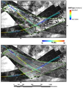
SARTopo data: SARTopo [8] is very useful
in corroborating and quantifying PC’s en-hanced transitions and complementary to the information derived from the central beam high-resolution radiometry (Fig.1).
Fig. 1. PC1 and PC2 SAR mosaic and beam 3 high-resolution radiometry of Hotei Arcus T41-T43-T121.
1028.pdf Lunar and Planetary Science XLVIII (2017)
VIMS data:
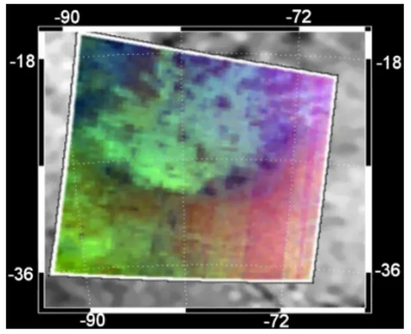
The Hotei Arcus is of particular interest as it shows one of the brightest features in ISS near-IR data and in the 5 micrometer VIMS channel [9,10] and possible presence of wa-ter-ice [2]. The latest coverage of Hotei Arcus by VIMS flyby T47 is promising (Fig. 2). Ongoing work is underway in the use of PCA to isolate unique contribution to outline sur-face compositional differences. Correlation with SAR principal components may allow enhancing possible links between geological structures and local composition (e.g. water-ice vs. organics).
Discussion:
Analysis through PCA using SAR and VIMS is ongoing, including comparisons to other regions on Titan, such as the Belet sand seas covered by T08, T21-T50 and T61, which would offer a good coverage in terms of azimuth and incidence angles. In SAR, additive noise introduced by geometric ef-fects is removed in the PCA components. In VIMS, additive noise from atmospheric scat-tering, still present in most of the infrared windows, might be reduced through PCA, thus integration of SAR and VIMS compo-nents, along with radiometry data and SAR-Topo, could help in the interpretation of wa-ter-ice vs. organics components in relation to surface features and structures on Titan.
Fig. 2. VIMS cube (R =1.59/1.27µm, G=2.07/1.27µm, B=1.27/1.08µm) of Hotei Arcus at T47.
References: [1] Wall et al. (2009) Geo-physical Research Letters, 36. [2] Soderblom
et al. (2009) Icarus 204, 610. [3] Radebaugh et al. (2011) Icarus 211, 672 [4] Paganelli et al. (2016) Eos Trans AGU, Abstr. P51C-2158. [5] Lucat et al. (2014) JGR
10.1002/2013JE004584. [6] Paganelli et al. (2007) Icarus 191, 211. [7] Janssen et al. (2016) Icarus270, 443. [8] Styles et al.
(2009) Icarus 202, 584. [9] Barnes et al. (2005) Science 310, 92. [10] Rodriguez et al. (2006) PSS 54, 1510.
1028.pdf Lunar and Planetary Science XLVIII (2017)