Digital imaging for assessing and improving highway visibility
Aubert D.
a, Boucher V.
b, Brémond R.
a, Charbonnier P.
b, Cord A.
a, Dumont E.
a,*, Foucher P.
b,
Fournela F.
b, Greffier F.
b, Gruyer D.
a, Hautière N.
a, Muzet V.
b, Nicolle P.
a, Tarel J.-P.
aa
IFSTTAR, Marne la Vallée, Nantes & Versailles, France
b
CEREMA, Angers & Strasbourg, France
Abstract
Ifsttar is working with the scientific network of the French Department of Transportation to foster innovative camera-based solutions for assessing and improving highway visibility. This paper proposes an overview of the computer vision methods which result from this work. It encompasses camera-based advanced driver assistance systems (ADAS), camera-based traffic monitoring systems and camera-based road inspection systems. It also tackles the question of validation.
Keywords: highway visibility; imaging; computer vision; weather; lighting; driver assistance systems; road
operations; road inspection.
Résumé
L‟Ifsttar mène des recherches avec le Réseau Scientifique et Technique du Ministère français des Transports pour favoriser l‟émergence de solutions innovantes exploitant les caméras pour évaluer et améliorer la visibilité routière. Cet article passe en revue les méthodes de vision par ordinateur qui ont été développées dans le cadre de ce travail. Les trois principaux domaines d‟application de ces outils sont couverts : les aides à la conduite, la régulation du trafic et l‟inspection de la route. La validation des outils est également abordée
Mots-clé: visibilité routière; imagerie; vision par ordinateur; conditions météorologiques; éclairage; aides à la
conduite; exploitation de la route; inspection de la route.
*
Tel.: +33-1-8166-8349
1. Introduction
In-depth accident investigations have shown that a significant part of traffic accidents results from drivers failing to grasp the road situation. One way to improve traffic safety is to provide adequate highway visibility in order to help drivers adopt adequate behaviours (speed, headway, etc.). Such help can come from the infrastructure (traffic control systems) and from the vehicle (driver assistance systems). Either way, visibility must be monitored in order to detect problems and to provide tailored solutions. Video cameras, which are becoming ubiquitous both on roadsides and on-board vehicles, offer a great potential in this matter. Ifsttar & Cerema are working to foster innovative camera-based solutions for assessing and improving highway visibility. This paper gives an overview of the computer vision methods which result from this work; detailed descriptions of the methods, and how they compare to the state-of-the-art, can be found in the cited papers.
On-board cameras capture the visual signal in which the driver seeks the information he needs to perform a safe driving task. Processing this signal in real time allows detecting useful information such as pavement markings and road signs, or hazards such as obstacles, in order to assess time to lane crossing, time to collision or other risk indicators. It is also possible to detect reduced visibility conditions such as fog, rain, or glare, and even to quantify their impact on sight distance or target visibility, in order to provide speed warning or to tune advanced automotive lighting or signalling systems. In some cases, visibility can even be restored, up to a point, by de-hazing and in-painting techniques.
Roadside cameras allow the road operator to remotely monitor traffic on its network, with the help of automatic incident detection. Image processing techniques developed for in-vehicle cameras have been successfully adapted to such sensors, making it possible for the road operator to monitor weather and lighting conditions, in order to provide relevant warning or guidance to approaching traffic by means of variable message signs or LED-based adaptive road signalling and lighting systems.
Highway images recorded by road monitoring vehicles for asset management can be processed offline to extract visibility-related descriptors. Pavement markings and road signs can be detected and recognized, their visibility and saliency can be estimated automatically; the performance of road lighting can be assessed dynamically; thanks to such tools, the road operator can optimize the maintenance of its equipment. Preliminary results have also been obtained with automatic highway environment classification, which should eventually contribute to the evaluation of the self-explaining quality of the road.
In order to test, evaluate and benchmark these computer vision algorithms, image databases with ground-truth from instrumented sites and test vehicles are needed. Since such databases are difficult to establish, physically-based computer graphics simulation can be relied on.
2. Camera-based driver assistance systems
2.1. Lane markings, obstacles and road signs detection
In many driver assistance systems (ADAS) aiming at helping the driver perceive the road environment, the position and the orientation of the vehicle with respect to the roadway needs to be estimated; it is the case for lane departure warning, lane change assistance and collision avoidance. These parameters can be obtained by detecting the markings with single or stereo cameras; several algorithms have been proposed, using different geometric lane marking models such as parallel lines (Tarel et al., 1999), sets of line segments (Labayrade et al., 2006) or polynomial curves (Tarel et al., 2008).
For collision avoidance, we rely on the stereo approach because it allows detecting an object independently of its aspect thanks to the U-V disparity algorithm that we introduced to detect the presence of planar objects such as the roadway or the sides of vehicles (Labayrade et al., 2002). We also proposed a new ADAS for drawing drivers‟ attention to road signs with poor visual saliency, based on the confidence value returned by the sign detection algorithm (Simon et al., 2009).
2.2. Detection and characterization of adverse weather conditions
Despite their price and versatility, cameras have their caveats. One major problem is that cameras can be totally or partially blind under adverse weather conditions, when the systems they feed are most needed. Detecting and quantifying degradations of the signal and identifying their causes constitute a strong challenge for ADAS. It involves estimating a confidence index, and it involves self-diagnosis. It also brings out new driver assistance systems. Ifsttar was a precursor in many of the adverse visibility conditions research activities, in particular for on-board daytime and night-time fog detection, characterization and image restoration. More recently, we extended our activities to rain by detecting focussed and defocussed raindrops on the windshield.
During daytime fog, sunlight is scattered by airborne droplets, leading to the perception of an atmospheric veil, also known as “airlight”. The contrast attenuation caused by airlight is well described by Koschmieder‟s law, which accounts for the density of fog. The developed idea was to instantiate its parameters using a daytime fog image. It was done by the location of an inflexion point in the vertical luminance profile, directly linked to the fog density and therefore to the meteorological visibility distance (Lavenant et al., 2002; Hautière et al., 2006; Hautière et al., 2011).
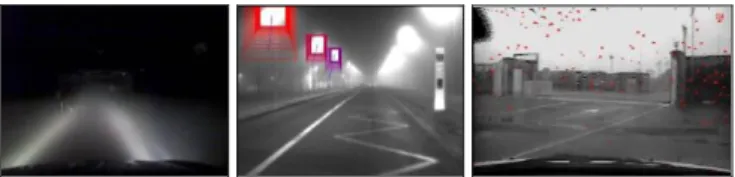
At night, airlight is no longer present, but light from the headlamps is reflected by the slab of fog in front of the vehicle back toward the driver, producing a back-scattered veil (Fig. 1, left). This phenomenon is always present, but it is no longer visible in the presence of external light sources like public lighting or the headlights of other vehicles. In such cases, according to the atmospheric modulation transfer function (MTF) theory, a halo is perceived around light sources (Fig. 1, center). Thus, to detect and characterize night-time fog, we developed two complementary techniques. The first one relies on the detection of the halos through a segmentation and pattern recognition process. The second one detects the presence of the backscattering veil of the ego-lights by comparing different reference images with the current image grabbed by the camera (Gallen et al., 2011). Based on the latter, and for the first time as far as we know, a preliminary methodology was proposed to deduce a rough fog density.
For the rain condition, focussed raindrops detection was first developed. A raindrop on the windshield produces a fuzzy reversed image of the background, inducing a localized high gradient that allows its location. False detections are filtered out relying on shape characteristics and temporal properties. The characterization is obtained by measuring the windshield surface covered by raindrops (Cord & Aubert, 2011) (Fig. 1, right). Assessment of the method has proved its efficiency.
Fig. 1. Visual effects of night-time fog: backscattering from the headlamps (left) and halos around streetlights (center); results of raindrop detection on the windshield (right, with detected raindrops in red).
To deal with defocussed raindrops, which are more likely to be observed with a camera close to the windshield, several approaches were developed, evaluated and compared. The general idea is to highlight the drops in the image, then to perform a segmentation and finally to filter out false detections by pattern recognition (Cord & Gimonet, 2013). The techniques only differ in the highlighting process. This development constitutes a strong progress in the state of the art even if obtained results are still not up to on-board applications.
2.3. Image restoration in adverse weather conditions
Extending the functional range of ADAS in adverse weather conditions could be done by dynamically adjusting sensor parameters or by improving the signal, through image contrast restoration. As head-up displays become more standard in vehicles, dynamic image restoration could also improve human perception in adverse situations. However, contrast enhancement for a single embedded camera is an ill-posed problem: due to the physics of fog, both the luminance without fog and the depth need to be estimated, so there are two unknown parameters per pixel.
In our first attempts at solving the problem, we proposed several simple parametric geometric models dedicated to the road scene in front of the vehicle. For each model, the parameters are fit by maximizing scene depths globally without producing black pixels in the enhanced image (Hautière et al., 2007). More recently, we proposed an algorithm relying on a local spatial regularization, using the planar road assumption (Tarel et al., 2012; Tarel et al., 2010). Being local, this algorithm can cope with homogeneous and heterogeneous fog. A different algorithm based on an iterative reconstruction process was also proposed with and without the road planar assumption (Halmaoui et al., 2011) (Fig. 2). We have also opened a new way to tackle fog image restoration, with a stereo-vision process which estimates the depth of the scene and performs the restoration in parallel (Caraffa & Tarel, 2012), which might solve problems encountered both by classical stereo techniques in fog and by mono-camera restoration techniques. Several tests with a road sign detection and recognition system proved that the image restoration improves both the range and the score of the detection. Tests with human observers also showed the usefulness of restoration in terms of both reaction time and detection capability, and therefore in terms of safety.
Fig. 2. Synthetic image of a foggy road scene (left) and the result of visibility restoration (right).
3. Camera-based traffic monitoring
Because they are low-cost and versatile, digital cameras are becoming ubiquitous on the sides of the road. Initially, the images were merely relayed by CCTV to traffic operations centers for remote human surveillance. Nowadays, thanks to advanced computer vision techniques, part of the traffic monitoring can be performed automatically, which helps road operators react faster to problematic situations in order to maintain quality of service, in terms of both safety and mobility. Video surveillance systems now come with “intelligence” to extract useful information from the video stream. This opens new opportunities for adaptive signalling and lighting systems, the deployment of which is facilitated by the development of LED technology. At Ifsttar, we looked into the feasibility of using traffic surveillance cameras to assess weather conditions.
3.1. Meteorological visibility distance estimation
Starting from the techniques developed to detect and characterize low atmospheric visibility conditions (optical range between 50 and 400 meters) using a vision system on-board a vehicle as described in Section 2.2, we looked into how they could be adapted to work with images from a roadside camera. The only difference lies in the fact that we cannot predict the location of the pavement surface, which serves to extract the luminance profile needed to instantiate Koschmieder‟s law. So we proposed to introduce an initialization step during which moving objects are accumulated in order to automatically map the driving space in the scene (Fig. 3). The patented method described in (Lavenant et al., 2002) can then be applied to estimate the meteorological visibility distance. However, the accuracy of the estimation depends on the characteristics of the camera (sensor size and focal length) and on the geometric configuration (camera height and angle) (Hautière et al., 2008).
Fig. 3. Mobile objects in the road scene (left) are accumulated to segment the driving area (center), over which Koschmieder‟s law is instantiated (right, red line) to estimate the atmospheric visibility distance (right, black line).
Methods based on Koschmieder‟s law work in daytime fog only. In the absence of “airlight”, we have to rely on the extinction of the intensity of artificial light sources in the scene to assess the atmospheric condition, using Beer-Lambert law. But we showed that the problem is then complicated by the influence of the particle size
distribution of the fog: bigger-droplet fogs create more forward scattering, which leads to significantly overestimate the optical range, especially when it is low. We proposed a method to classify and correct the bias caused by forward scattering at night, but it needs three light sources of known intensity, located at different known distances from the camera, which makes it more difficult to deploy than the daytime method (Gallen et al., 2010).
3.2. Detection of rain and snow
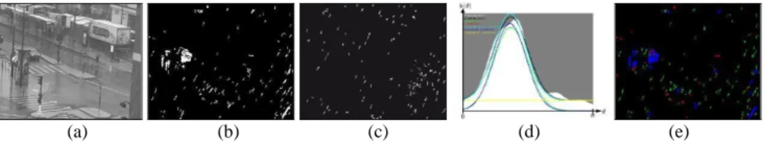
Precipitations such as rain or snow have important effects on the visual environment of the road users (low atmospheric visibility, specular reflections, etc.), not to mention the reduced skid resistance on the pavement. Hence, it is useful to be able to detect such meteorological events. We proposed a method to detect strong rain or snow in daytime, using a roadside camera (Bossu et al., 2011). A background image is built in order to detect moving objects; those objects which are potential hydrometeors are then selected based on their size and photometry, and the histogram of their orientations is built; finally, the consistent presence of a peak in the histogram is tested over a small period of time to decide on the presence of falling raindrops or snowflakes (Fig. 4). Although we still lack reference data, we showed that the amplitude of the peak might indicate the intensity of the precipitation.
(a) (b) (c) (d) (e)
Fig. 4. Precipitation detection: (a) original video frame; (b) segmentation of moving objects; (c) selection of potential hydrometeor streaks; (d) orientation histogram; (e) detection of falling raindrops or snowflakes (green pixels).
4. Camera-based road inspection
Cameras are used for road inspection and assets management, for the same reasons as for ADAS, with two differences: real-time is not required because data can be processed off-line, and the lighting and weather conditions must be “normal” because the results will characterize intrinsic features of the highway. Two camera-based systems were developed which can be installed aboard a road operation vehicle, and which record and analyze road images to inspect itineraries (Fig. 5). IRCAN (mlpc®) is calibrated geometrically, in order to extract position and sight distance information from the digital images it records, using the associated software IREVE (mlpc®). CYCLOPE is calibrated photometrically and colorimetrically, in order to extract luminance and contrast information from the images. Thus, they are complementary tools to assess the visibility offered by the road and its equipment in both geometric and photometric aspects.
Fig. 5. IRCAN mlpc® (left) and CYCLOPE (right) are camera-based road inspection systems.
4.1. Sight distance
Sight distance along the roadway plays a significant role in road safety. In particular, it has a clear impact on the choice of speed limits. Although sight distance criteria are routinely taken into account in road design, only a few systems exist for estimating it on existing road networks. It was shown in (Charbonnier & Tarel, 2010) that direct evaluation of the available geometric visibility from stereovision image sequences is not reliable. However, geometrically calibrated images sequences can be helpful to build 3D models of the road and its surroundings, as an alternative to LiDAR imaging using structure from motion. With such models in hand, standard algorithms from computer graphics (Z-buffering, ray-tracing) can be exploited to successfully assess the available sight distance (Charbonnier & Tarel, 2010).
4.2. Lighting performance, visibility level and glare
But the fact that an object is in sight does not mean a road user can actually see it. The object must also suit the acuity and contrast sensitivity of the human visual system (HVS), which change with adaptation and age. Photometric visibility is evaluated from luminance, which is the visual impression generated by light emitted, reflected and scattered toward the observer. Relative luminance differences (i.e. contrast) and visibility level (i.e. ratio of actual contrast and threshold contrast) are classical indicators of photometric visibility (Brémond et al., 2013). They can be extracted from luminance maps such as those measured with CYCLOPE (Boucher et al., 2008), in various lighting and weather conditions (Fig. 6), especially with a high dynamic range camera. A visual adaptation model can also be used to assess glare, which impairs visibility. Furthermore, the luminance maps can also provide luminance levels and uniformities, which are standard indicators of the performance of road and tunnel lighting installations.
Fig. 6. Visibility level of pavement markings and road signs in night-time (left) and daytime (right) foggy conditions, acquired with CYCLOPE.
4.3. Pavement markings and road signs detection
As explained in Section 2.1, lane markings are important to be detected to build reliable ADAS. For road inspection and in particular for checking the visibility of all markings, it is necessary to detect lane markings as well other “special” markings. The detection of special markings is difficult due to variability of their aspect and hierarchical structure, which may be composed of several sub-markings. We have investigated this problem for urban markings, such as arrows and pedestrian crossing (Foucher et al., 2011).
It is also interesting for road inspection to check the position and visibility of the road signs, as well as their saliency in their complex environment. They first need to be detected and recognized, for instance using the algorithms we developed and compared in (Belaroussi et al., 2010). Then their visibility (Section 4.2) and saliency (Simon et al., 2010) can be estimated.
4.4. Road environment classification
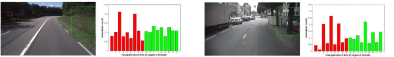
We feel that image analysis methods might also provide indicators of the self-explaining quality (or legibility) of the road. We have looked into segmenting routes into road sections where the visual environment hints at different road categories. We obtained promising preliminary results with a binary classification of road scenes into urban or rural categories. The classification uses colour histograms and histograms of oriented gradients as input features, computed in regions of interest of the image (Fig. 7). The proposed algorithm still needs to be systematically evaluated on large image databases. We are currently investigating road scene classification into categories based on the speed limits, as perceived by the driver.
Fig. 7. Road scene classification in two categories: rural (left) & urban (right), based on the histograms of oriented gradients in two regions of interest.
5. Evaluation
5.1. Ground-truth
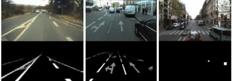
In order to test and evaluate the previously listed computer vision algorithms, we have built along the years several image databases with ground-truth from instrumented sites and vehicles. Most of them are available online for research purposes. They contain hundreds or thousands of highway or street images, and to each image is attached ground-truth data or a ground-truth image (Fig. 8). For instance the ROMA/ROMA2† databases are for lane marking element extraction and lane marking detection, while the MItowns‡ and PITowns databases are dedicated to the detection and recognition of special lane markings and signs, respectively.
Fig. 8. Samples from Ifsttar-Cerema ground-truth databases for testing lane markings (left), special markings (center) and road signs (right) detection and recognition.
5.2. Simulation
Acquiring ground-truth data is a difficult process, especially for low visibility conditions, so we also rely on physically-based computer graphics simulations, where the studied parameters can be controlled.
PROF-LCPC§ is a Monte Carlo light tracer which we developed to study the visual effects of fog for drivers (Dumont, 1998). It accounts for the photometric properties of light sources, surfaces and scattering medium, and generates a luminance map of the scene as it would be captured by a photometrically calibrated pinhole camera. It served to test several visibility assessment techniques among those presented in Sections 2.2, 3.2 and 4.2.
SiVIC, on the other hand, is a real-time simulation platform which we developed for prototyping perception applications based on optical sensors, especially those described in Section 2 (Gruyer et al., 2006). It serves to generate virtual sensor data, and special efforts went into the physical model of the imaging sensors (Gruyer et al., 2012) (Fig. 9). It can also generate virtual reference data (ground-truth), such as labelling images or depth maps, as well as object position, speed and other dynamical parameters. Test protocols have been proposed based on such data, to validate obstacle detection and tracking with stereo-vision (Fakhfakh et al., 2013) (Fig. 10).
Fig. 9. Images of a test track grabbed by a real camera (left) and rendered with SiVIC (right).
We also developed an application to generate shape-based and pixel-based reference data for the validation of lane marking detection and tracking (Revilloud et al., 2013), using natural bitumen textures to account for the type and wear or the pavement markings (Fig. 11).
† http://www.lcpc.fr/english/products/image-databases/article/roma-road-markings-1817
‡
http://www.itowns.fr/benchmarking.html
§
Fig. 10. Stereo processing for obstacle detection and tracking with dense disparity map, simulated with SiVIC.
Fig. 11. Sample road textures with worn lane markings (left), applied in a virtual road scene with SiVIC (right).
Several virtual ground-truth databases were created with SiVIC. The FRIDA series** , †† (Fig. 12) serve to evaluate our computer vision algorithms aiming at restoring visibility with or without stereo-vision (Section 2.3). FROSI‡‡ is available for the evaluation of road sign detection in foggy weather. And VeLaSca‡‡ is available for obstacle detection with mono-vision and telemetric sensor (Gruyer et al., 2013). New databases will be made available for stereovision detection and for multi-lane road marking detection.
Fig. 12. Samples from Ifsttar synthetic image databases; from left to right: homogeneous fog, heterogeneous fog, no fog, and the depth map of the road scene, rendered with SiVIC.
6. Conclusions
Ifsttar & Cerema have worked out several computer vision solutions over the past years to assess and improve highway visibility for applications in camera-based driving assistance, traffic monitoring and road inspection systems. We have also built ground-truth databases to test these solutions, and made these databases available to others for benchmarking. These solutions will profit traffic safety countermeasures (Babari et al., 2012; Gallen et al., 2013), as well as emerging cooperative systems which combine real-time information gathered from onboard units (OBU) and roadside units (RSU) with structural information gathered with road inspection vehicles (Hautière & Boubezoul, 2009). We thus opened the way into new research fields – such as daytime fog detection, characterization and contrast restoration with on-board cameras – which have since been taken up worldwide.
However, there are still scientific challenges to deal with (night fog characterization or defocussed raindrops detection, for instance) and some opened issues (algorithms optimization to run them on the same camera at the same time). Up to now much of the research was concentrated on the camera perception, and it would be useful to estimate a transfer function between sensor and human perception (Joulan et al., 2011), for instance to detect an inadequacy between vehicle speed and driver visibility distance. Also, we have only dealt with a part of the problem in the estimation of a confidence index on the operation of a camera-based ADAS and its self-diagnosis. Indeed, situations such as snow, glare, mist or dust on the windshield, for instance, were not investigated. In fact, all situations that affect the video signal must be taken into account. So Ifsttar & Cerema will keep on investigating the use of digital images to assess and improve highway visibility.
** http://www.lcpc.fr/english/products/image-databases/article/frida-foggy-road-image-database
††
http://perso.lcpc.fr/tarel.jean-philippe/visibility/fogstereo.zip
‡‡
Acknowledgements
The work presented in this paper was supported through several projects at National (ARCOS, SARI, DIVAS, ITOWNS), bi-National (ICADAC) and European (SAFESPOT, CARSENSE) levels.
References
Babari, R., Hautière, N., Dumont, E., Paparoditis, N., & Misener, J. (2012). Visibility monitoring using conventional roadside cameras – Emerging applications. Transportation Research Part C, 22, 17 - 28.
Belaroussi, R., Foucher, P., Tarel, J.-P., Soheilian, B., Charbonnier, P., & Paparoditis, N. (2010). Road sign detection in images: A case study. In Proc. International Conference on Pattern Recognition (ICPR), pp. 484-488.
Brémond, R., Bodard, V., Dumont, E., & Nouailles-Mayeur, A. (2013). Target visibility level and detection distance on a driving simulator. Lighting Research and Technology, 45, 76-89.
Boucher, V., Greffier, F., & Fournela, F. (2008). High speed acquisition system of photo-colorimetric images to record and to model the human visual signal. In Proc. SPIE 7073, Applications of Digital Image Processing
XXXI.
Caraffa, L., & Tarel, J.-P. (2012). Stereo reconstruction and contrast restoration in daytime fog. In Proc. Asian
Conference on Computer Vision (ACCV), pp. 13-25.
Charbonnier, P., & Tarel, J.-P. (2010). On the diagnostic of road pathway visibility. In Proc. Transport Research
Arena (TRA).
Cord, A., & Aubert, D. (2011). Towards rain detection through use of in-vehicle multipurpose cameras. In Proc.
IEEE Intelligent Vehicles Symposium (IV), pp. 833-838.
Cord, A., & Gimonet, N. (2013). Unfocused raindrops detection for in-vehicle multipurpose cameras. IEEE
Robotics and Automation Magazine, Special issue on Perception and Navigation for Autonomous Vehicles.
Dumont, E. (1998). Semi-Monte Carlo light tracing applied to the study of road visibility in fog. In Proc. Monte
Carlo and Quasi-Monte Carlo Methods (MCQMC), pp.177-187.
Fakhfakh, N., Gruyer, D., & Aubert, D. (2013). Weighted V-disparity approach for obstacles localization in highway environments. In Proc. IEEE Intelligent Vehicles Symposium (IV), pp. 1271-1278.
Foucher, P., Sebsadji, Y., Tarel, J.-P., Charbonnier, P., & Nicolle, P. (2011). Detection and recognition of urban road markings using images. In Proc. IEEE Conference on Intelligent Transportation Systems (ITSC), pp. 1747-1752.
Gallen, R., Hautière, N., & Dumont, E. (2010). Static estimation of the meteorological visibility distance in night fog with imagery. IEICE Transactions on Information and Systems, E93-D(7), 1780 - 1787.
Gallen, R., Cord, A., Hautière, N., & Aubert, D. (2011). Towards night fog detection through use of in-vehicle multipurpose cameras. In Proc. IEEE Intelligent Vehicles Symposium (IV), pp. 399-404.
Gallen, R., Hautiere, N., Cord, A., & Glaser, S. (2013). Supporting drivers in keeping safe speed in adverse weather conditions by mitigating the risk level. IEEE Transactions on Intelligent Transportation Systems, 14(4), 1558 - 1571.
Gruyer, D., Royère, C., du Lac, N., Michel, G., & Blosseville, J.-M. (2006). SiVIC and RT-Maps interconnected platforms for the conception and the evaluation of driving assistance systems. In Proc. ITS World Congress.
Gruyer, D., Grapinet, M., & De Souza, P. (2012). Modeling and validation of a new generic virtual optical sensor for ADAS prototyping. In Proc. IEEE Intelligent Vehicles Symposium (IV), pp. 969-974.
Gruyer, D., Cord, A., & Belaroussi, R. (2013). Vehicle detection and tracking by collaborative fusion between laser scanner and camera. In Proc. IEEE International Conference on Intelligent Robots and Systems (IROS).
Halmaoui, H., Cord, A., & Hautière, N. (2011). Contrast restoration of road images taken in foggy weather. In
Proc. IEEE Computer Vision in Vehicle Technology (CVVT), pp. 2057-2063.
Hautière, N., Tarel, J.-P., Lavenant, J., & Aubert, D. (2006). Automatic fog detection and estimation of visibility distance through use of an onboard camera. Machine Vision and Applications Journal, 17(1), 8 - 20.
Hautière, N., Tarel, J.-P., & Aubert, D. (2007). Towards fog-free in-vehicle vision systems through contrast restoration. In Proc. IEEE Conference on Computer Vision and Pattern Recognition (CVPR), pp. 1-8.
Hautière, N., Bigorgne, E., & Aubert, D. (2008). Daytime visibility range monitoring through use of a roadside camera. In Proc. IEEE Intelligent Vehicles Symposium (IV), pp. 470-475.
Hautière, N., & Boubezoul, A. (2009). Combination of roadside and in-vehicle sensors for extensive visibility range monitoring. In Proc. IEEE Advanced Video and Signal Based Surveillance (AVSS), pp. 388-393.
Hautière, N., & Tarel, J.-P. (2011). Rain or snow detection in image sequences through use of a histogram of orientation of streaks. Computer Vision, 93(3), 348 - 367.
Hautière, N., Tarel, J.-P., Halmaoui, H., Brémond, R., & Aubert, D. (2011). Enhanced fog detection and free space segmentation for car navigation. Machine Vision and Applications Journal, Special issue on car navigation and vehicle systems, 1 - 13.
Joulan, K., Brémond, R., & Hautière, N. (2011). A unified CSF-based framework for edge detection and edge visibility. In Proc. IEEE Computer Vision and Pattern Recognition Workshops (CVPRW), pp. 51-56.
Labayrade, R., Aubert, D., & Tarel, J.-P. (2002). Real time obstacle detection on non flat road geometry through „V-disparity‟ representation. In Proc. IEEE Intelligent Vehicles Symposium (IV), pp. 646-651.
Labayrade, R., Douret, J., Laneurit, J., & Chapuis, R. (2006). A reliable and robust lane detection system based on the parallel use of three algorithms for driving safety assistance. EICE Transactions on Information and
Systems, E89D(7), 2092 - 2100.
Lavenant, J., Tarel, J.-P., & Aubert, D. (2002). Method for determining the range of visibility and method for detecting the presence of fog. European Patent EP1474652 by LCPC/INRETS.
Revilloud, M., Gruyer, D., & Pollard, E. (2013). A new approach for robust road marking detection and tracking applied to multi-lane estimation. In Proc. IEEE Intelligent Vehicles Symposium (IV), pp. 783-790.
Simon, L., Tarel, J.-P., & Brémond, R. (2009). Alerting the drivers about road signs with poor visual saliency. In
Proc. IEEE Intelligent Vehicles Symposium (IV), pp. 48-53.
Simon, L., Tarel, J.-P., & Brémond, R. (2010). A model for automatic diagnostic of road signs saliency. In Proc.
Transport Research Arena (TRA).
Tarel, J.-P., Guichard, F., & Aubert, D. (1999). Tracking occluded lane-markings for lateral vehicle guidance. In N. Mastorakis (Ed.), Recent Advances in Signal Processing and Communications (pp. 154-159). Danvers: WSEAS Press.
Tarel, J.-P., Ieng, S.-S., & Charbonnier, P. (2008). A constrained-optimization based Hal-quadratic algorithm for robustly fitting sets of linearly parameterized curves. Advances in Data Analysis and Classification, 2(3), 227 239.
Tarel, J.-P., Hautière, N., Cord, A., Gruyer, D., & Halmaoui, H. (2010). Improved visibility of road scene images under heterogeneous fog. In Proc. IEEE Intelligent Vehicles Symposium (IV), pp. 478-485.
Tarel, J.-P., Hautière, N., Cord, A., Halmaoui, H., Carafa, L., & Gruyer, D. (2012). Vision enhancement in homogeneous and heterogeneous fog. IEEE Intelligent Transportation Systems Magazine, 4(2), 6 - 20.