http://dx.doi.org/10.4236/jwarp.2015.713080
Trend Analysis in Ecological Status and
Macrophytic Characterization of
Watercourses: Case of the Semois-Chiers
Basin, Belgium Wallonia
Sossey-Alaoui Khadija, Rosillon Francis, Tychon Bernard
Department of Environmental Sciences and Management (DSGE), University of Liege, Arlon, Belgium Email: [email protected], [email protected], [email protected]
Received 11 June 2015; accepted 30 August 2015; published 4 September 2015 Copyright © 2015 by authors and Scientific Research Publishing Inc.
This work is licensed under the Creative Commons Attribution International License (CC BY).
http://creativecommons.org/licenses/by/4.0/
Abstract
In order to analyze the distribution and evolution of the aquatic vegetation and ecological status of the Semois-Chiers basin (Semois sub-basin and Chiers sub-basin), macrophyte surveys were con-ducted at 48 sites in 2007 and 2013. Environmental parameters were also measured in order to characterize the waterbodies in terms of physico-chemical properties and anthropogenic pressure. The two-way clustering and indicator value (INDVAL) methods were used to assess groups of sites according to their macrophytic composition and species communities. The results showed a clear difference between streams in the Lorraine area (calcareous watercourses) and in the Ardennes (siliceous). Within each natural region, those with natural vegetation of high ecological status were separated from those dominated by resistant species. The Macrophytical Biological Index for Rivers (IBMR) was calculated for the sites visited in 2010 and 2013 and the results show a trend towards an increase of IBMR values of polluted sites. For the latter, the Wilcoxon test was per-formed to assess the significance of the difference in quality between 2010 and 2013. This showed a statistically significant difference (p-value = 0.035). Our results showed similarities with pre-vious data, as well as some differences. The differences observed might indicate a gradual change in the composition of the vegetation in the study area, which was caused by changes in environ-mental conditions. They could also reflect a lack of information about the ecology of certain groups of plants, mainly bryophytes and macroalgae that were not considered in previous studies. Despite the measures implemented under the EU’s Water Framework Directive (WFD), the cur-rent vegetation of the Semois river differs little from that observed in 1996. The headwaters of a Semois river, described in previous studies as polytrophic and devoid of vegetation, show a slight improvement, with the appearance of macrophytic species. In some parts of the Chiers sub-basin, however, resistant species observed in 1999 persist.
Keywords
Macrophytes, Semois-Chiers Basin, WFD, IBMR, Ecological Quality
1. Introduction
Under the European Union’s Water Framework Directive (WFD), the ecological status of a water body is eva-luated on the basis of three main factors: biology, physical chemistry and hydromorphology. Macrophytes are an essential element in the functioning of aquatic ecosystems and are widely used in WFD work to assess ecologi-cal quality. In the Semois-Chiers basin, however, information on aquatic macrophytes is limited, apart from that in the work reported by [1]-[22]. Results from earlier studies on watercourses in this area were revised and up-dated by Thoen et al. [23] in a study conducted between 1993 and 1994.
Initiated in 1993 and focusing partly on a diachronic study of aquatic macrophytes as bio-indicators of water quality evolution in the Semois-Chiers basin, Thoen et al. [23] conducted an environmental study of the Semois river from its source to its confluence with the Meuse. The study brought together a great amount of new data on aquatic pond plants. Many species have since been reported for the first (or second) time in the Semois-Chiers basin. Thoen et al. [23] showed that there was a longitudinal succession of species along the Semois river and that this succession was determined by eco-chemical factors. They described macrophytic groups over a distance of 200 km based on an analysis of 218 botanical records. Although this study was important, it focused only on the main course of the Semois, not its tributaries, and only on the phanerogam group of plants.
In work carried out by Symoens [24], Dethioux [25] and Sossey-Alaoui [26], stream vegetation was defined in relation to physical descriptors and limited information was provided on the impact of human activities on ecosystems. Studies were also conducted on vascular plants and some information was provided on bryophytes and macroalgae. In these studies, the reference conditions were not specified and the communities studied in-cluded both sensitive and resistant species.
Despite these studies, the Semois-Chiers area remains under-surveyed. In terms of the regional distribution of many plant species, significant gaps remain and there is a need to update information in the light of recent changes in aquatic and semi-aquatic flora and of the results of WFD surveys. The gaps have arisen mainly be-cause the aquatic vegetation of the area is difficult to study and often requires specialized equipment rarely used by botanists (high boots, canoes, rope with a grappling hook, and a curved-tooth trident with a telescopic arm).
Within the context of the WFD’s River Basin Management Plan, a measurement programme and monitoring network have been set up for each watershed. The Semois-Chiers waterbodies are covered by the Walloon net-work for monitoring surface water status. Between 2007 and 2013, this netnet-work undertook several macrophytic surveys of waterbodies [27]. The reference macrophytic communities were waterbodies classified by the Wal-loon Government as being areas showing little or no human impact [28].
In order to improve water quality, and to work within the framework of the River Basin Management Plan, the Walloon Government has supported the construction and expansion of wastewater treatment plants. Between 2000 and 2013, 29 such plants, with a capacity of 117,025PE, were built in the Semois-Chiers basin.
In our study, we sought to analyze trends in the Macrophyte Biological Index for Rivers (IBMR) values and macrophytic community characteristics by comparing previous results with those produced in 2013 within the context of the WFD. The specific objectives of the study were to: i) analyze the aquatic vegetation at 48 sites on various waterbodies in the Semois-Chiers basin; ii) define the characteristics of the macrophytic communities at these sites and identify their eco-chemical indicators; and iii) analyze trends in the IBMR values and macro-phytic community in order to identify any changes in the status of these sites resulting from measures imple-mented under the WFD.
2. Materials and Methods
Study Area Sites
Our study focuses on 48 sites along various waterbodies in the Semois-Chiers basin, which is part of the Meuse river basin and covers an area of 1759.34 km2, with the major rivers being the Chiers, Rulles, Semois and Vierre.
The area comprises two distinct geological units: the Ardennes in the northern part of the basin and Lorraine in the southern part (Figure 1). The Ardennes area consists of schists, sandstone and quartzophyllade and is cha-racterized by forests composed of deciduous and coniferous trees [27]. The Lorraine area consists of alternating impermeable (marl and clay) and permeable (conglomerates, sandstones, limestone and calcareous sandstones) ground. The alternating hard and soft layers of these deposits were originally eroded in formations called “cues-tas”. The Lorraine area is suitable for agriculture, but the tops and slopes of the cuestas are covered by forest.
The sites surveyed were mostly part of the monitoring network of Walloon surface waters. They represent various geological situations and physicochemical and anthropogenic pressures of the area. Some sites analyzed in 1999 [26] were revisited in 2013. Figure 1 shows the distribution of the 48 sites analyzed in the Semois- Chiers basin. The sampling methodology was carried out using the IBMR protocol [29]. The length of the stu-died water sections was 100 m. The estimation of coverage is carried out and sub-divided into five classes of abundance (class 1: <0.1%, class 2: from 0.1% - 1%, class 3: from 1% - 10%, class 4: from 10% - 50%, class 5: from 50% - 100%). The estimation of plant cover was made for riverbed and margins as a whole.
The submerged macrophytes were surveyed twice during the main growing periods in 2007-2008, 2008-2009 and 2012‐2013.
The physico-chemical parameters measured at 25 out of the 48 sites were: complete alcalimetric title (CTA) (˚F); conductivity (µS/cm) (microSiemens/cm); calcium (mg/l); orthophosphate (mgP/l); nitrite (mgN/l); ammo-nium (mgN/l); and pH. The measurements were made six times a year. The environmental parameters used (ar-tificial environments, agricultural land, forests and semi-natural habitats) are related to the percentage in the basin. For the vegetative data analysis, we used two-way clustering [30] to investigate stream groups in terms of their vegetation and indicator value (INDVAL) [31] in order to identify taxa characteristics of the floristic types that were present.
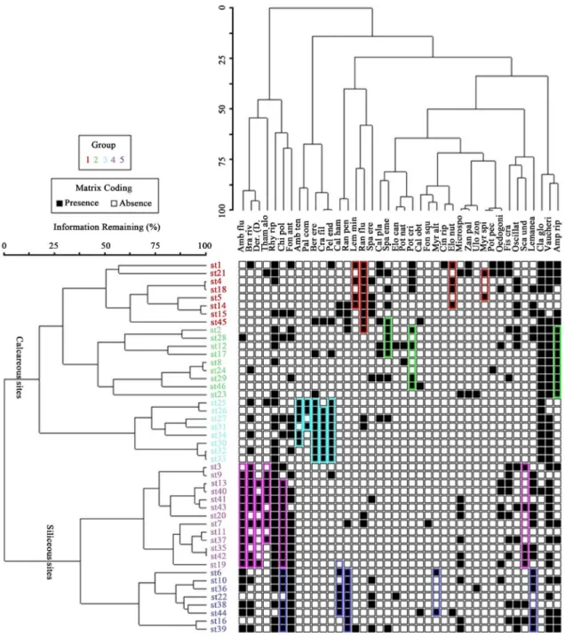
The two-way clustering method simultaneously assigns sites and species groups by performing two separate classification analyses, one on a matrix looking at groups within rows (sites) and the second on the transposed matrix looking at groups within columns (taxa) (Figure 2). The figure shows the two dendrograms resulting from the first group of lines (sites) and the second group of columns (species) of the matrix and the taxa abun-dance [27]. The INDVAL technique allows taxa characteristic of groups defined by the two-way clustering me-thod to be identified by calculating the abundance, relative frequency and INDVAL of each taxon in each group
[31]. In order to be considered as a characteristic or indicator group, a taxon must have an indicator species val-ue greater than 25%.
Figure 1. Distribution of the studied sites in five groups according to the results of two-way clustering analysis. Sites codes and reference in electronic Appendix 1).
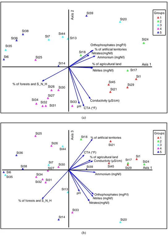
Principal component analysis (PCA) was performed to characterize the groups in terms of the physico-chemi- cal parameters of their environment.
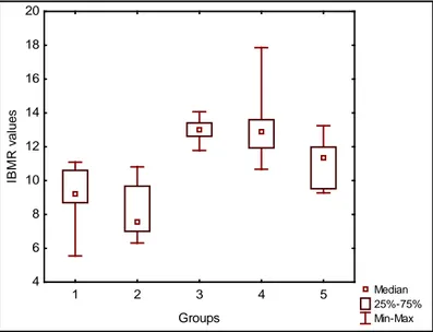
The IBMR [32] was calculated for each site and a box-whisker plot test was used to characterize the groups in terms of their trophic state.
3. Results and Discussion
3.1. Analysis of the Vegetation Distribution in the Semois-Chiers Basin
The two-way clustering method was used to investigate groups of sites determined by their emerging macro-phytic composition and species communities (Figure 2). Within the five groups defined, the results showed a
Figure 2. Results of two-way clustering analysis applied to the vegetation matrix of Semois-Chiers (Species abbreviations and full name are in electronic Appendix 2. Sites codes and reference in electronic Appendix 1).
clear difference between the Lorraine (calcareous watercourses) groups (2 and 3) and the Ardennes ones (sili-ceous) (4 and 5). Within each geological context, those with natural vegetation of high ecological quality were separated from those dominated by resistant species. Rivers, however, in both the Lorraine and the Ardennes, fell into Group 1.
PCA was performed to characterize the groups in terms of their physico-chemical and environmental parame-ters (Figure 3).
(a)
(b)
Figure 3. Results of the principal component analysis applied to the physico-chemical data of 25 out of the 48 sites studied. The sites are colour-coded in order to differentiate the five groups of sites determined by two-way clustering analysis. (a) Axis 1 and 2; (b) Axis 1 and 3. CTA = complete alcalimetric title (˚F); % of Forest and S-N-E: % of Forest and Semi-Natural Environment. St39 St20 St1 St24 St21 St17 St18 St30 St31 St32 St33 St27 St34 St25 St26 St7 St35 St36 St6 St38 St13 St44 St14 St45 St29 Ammonium (mgN/l) Conductivity (µS/cm) Nitrates(mgN/l) Nitrites (mgN/l) Orthophosphates (mgP/l) pH CTA (°F) % of artificial territories % of forests and S_N_H
% of agricultural land Axis 1
A xi s 2 Groups 1 2 3 4 5 St39 St20 St1 St24 St21 St17 St18 St30 St31 St32 St33 St27 St34 St25 St26 St7 St35 St36 St6 St38 St13 St44 St14 St45 St29 Ammonium (mgN/l) Conductivity (µS/cm) Nitrates(mgN/l) Nitrites (mgN/l) Orthophosphates (mgP/l) pH CTA (°F) % of artificial territories % of forests and S_N_H % of agricultural land Axis 1 A xi s 3 Groups 1 2 3 4 5
Lowland rivers (calcareous and siliceous watercourses) (Group 1)
Group 1 was characterized by sites on medium-sized streams and rivers in the Lorraine and by sites on large rivers in the Ardennes. The watercourse size was determined according to the typology used in Wallonia [33].
Figure 3 shows that these sites were characterized by high alkalinity and conductivity and a high concentra-tion of nitrates. They also had a eutrophic character and eutrophicaconcentra-tion indicator species, including Ranunculus fluitans, Myriophyllum spicatum and Lemna minor (Figure 2), as well as low IBMR scores (Figure 4).
Calcareous streams (Lorraine area) (Groups 2 and 3)
Group 2 stream sites, dominated by species indicative of eutrophication, predominated in agricultural areas and in the few forests in the watershed areas (Figure 3). These sites had high values in the various physico- chemical parameters considered in our study (orthophosphate [mgP/l]; nitrite [mgN/l] and ammonium [mgN/l] (Figure 3). They were along the upper Semois and Vire (the main tributary of the Ton in the Chiers sub-basin) located on plains, drained farmland and urban or industrial areas. Species characteristic of this group were Lep-todictyum riparium and Potamogeton crispus (Figure 2).
In contrast, Group 3 was characterized by low agricultural pressure and a strong dominance of forests in the watershed areas (Figure 3). It was also characterized by a macrophytic community dominated by species with a natural calcareous character of high biological value, including Hygroamblystegium tenax, Berula erecta, Cra-toneuron filicinum and Pellia endiviifolia (Figure 2), as well as high IBMR scores (Figure 4).
Siliceous streams (Ardennes area) (Groups 4 and 5)
The Group 4 sites were characterized by low agricultural pressure and a strong dominance of forests. Some sites were on tributaries on the right bank of the Semois river in the Ardennes, where the lithological deposits are quartzophyllades, phyllites, sandstones and psammites and the predominant land use is forestry (Figure 3). In terms of abundance and frequency, the main indicator species were Hygroamblystegium fluviatile, Chiloscy-phus polyanthus, Brachythecium rivulare, Dermatocarpon weberi, Thamnobryum alopecurum and Scapania undulata. These species have a very high indicator value and are therefore indicator species of high ecological status.
In contrast, the Group 5 sites were in areas with more agriculture and fewer forests (Figure 3) and were cha-racterized by taxa that tended to be less sensitive. This could be explained by these sites being on the Ardennes plateau, which was dominated by grasslands. This situation was also reflected in the IBMR results (Figure 4), where the trophic levels were average for most of these Group 5 sites.
In these disturbed sites small amounts of some species characteristic of the reference streams persisted, espe-cially Chiloscyphus polyanthus, Hygroamblystegium fluvialile Platyhypnidium riparioides and Brachythecium
Figure 4. IBMR values of the groups of sites defined by two-way clustering analysis. The box plot shows the central ten-dency of the variable in terms of median values (represented by the smallest box plot). The dispersion (variability) of the va-riable values is shown by quartiles (25th and 75th percentiles, larger box plot) and the minimum and maximum values of the variable (“whiskers” plot).
Median 25%-75% Min-Max 1 2 3 4 5 Groups 4 6 8 10 12 14 16 18 20 IB M R v al ues
rivulare. Others had disappeared and had been replaced by less sensitive species (e.g., higher plants, such as Callitriche hamulata, Ranunculus penicillatus and, to a lesser extent, Elodea nuttallii, Lemna minor, Callitriche platycarpa and Callitriche obtusangula, as well as macroalgae including Microspora sp. and Oedogonium sp. The quality difference between the sites of the two groups was also reflected in the difference of nitrate concen-tration (Figure 3).
3.2. Comparison with Previous Data
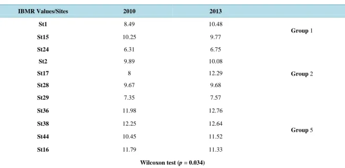
3.2.1. Analysis of Trends from 2010 to 2013Eleven sites in Groups 1, 2 and 5 characterized by resistant species were subjected to analyses, the first con-ducted in 2010 and the second in 2013. The IBMR results from these two analyses are given in Table 1, which shows a trend towards improved ecological quality. The Wilcoxon test was performed to assess the significance of the difference in quality between the two years. This produced a statistically significant difference (p-value of <0.05).
This trend could be related to an improvement in water quality, but also to the difference in climatic condi-tions (hydrology, temperature) not considered in this study between the two years.
3.2.2. Comparison of Results with Previous Data
In the Semois sub-basin, our comparative work focused mainly on phanerogams and on the main Semois river. Thoen et al. [23], who identified a set of macrophytic groups related to physico-chemical quality, focused only on the main Semois river. There are no results, therefore, for the Semois tributaries. Also, by focusing only on phanerogams, this meant excluding bryophytes and macroalgae, which had not been considered in previous stu-dies.
The IBMR results from these two analyses are given in Table 2, which shows a trend of increasing IBMR values.
The first kilometer after the source (St 46), a little downstream from the largest town (Arlon) in the basin, was described in 1982 by the authors and others [34] as polytrophic and lacking vegetation as a result of pollution.
The presence of species in this section today, although they are indicators of pollution (Leptodictyum ripa-rium and Cladophora glomerata), shows a tendency towards improvement in water quality. This could be the result of pollution control measures implemented by the Walloon Government under the WFD.
In an effort to improve sewage management in the Semois-Chiers basin, the Walloon Government is support-ing the construction and expansion of wastewater treatment plants. Between 2000 and 2013, 29 such plants with a capacity of 117,025 PE were built in the basin. This has led to an improvement in physico-chemical quality, Table 1. Ecological quality difference between 2010 and 2013 at 11 streams of Semois-Chiers basin.
IBMR Values/Sites 2010 2013 St1 8.49 10.48 Group 1 St15 10.25 9.77 St24 6.31 6.75 Group 2 St2 9.89 10.08 St17 8 12.29 St28 9.67 9.68 St29 7.35 7.57 St36 11.98 12.76 Group 5 St38 12.25 12.64 St44 10.45 11.52 St16 11.79 11.33 Wilcoxon test (p = 0.034)
Table 2. Comparison of Semois river results with previous data. Thoen et al. [23] results vs. 2013 results. Sites/Parameters St46 St8 St17 St2 St4 St5 1996 2013 1996 2013 1996 2013 1996 2013 1996 2013 1996 2013 Physico-chimical parameters Orthophosphate (mgP/l) 0.75 0.14 0.21 x 0.15 0.14 0.055 0.07 0.044 0.04 0.025 0.03 Nitrate (mgN/l) 3.1 x 2.02 2.72 1.64 1.84 1.64 2.17 1.8 1.92 Ammonium (mgN/l) 0.80 0.22 0.97 x 0.49 0.22 0.115 0.11 0.088 0.019 0.042 0.019 IBMR IBMR value 8.58 9.13 11 5.24 9.78 8.15 8.88 8.53 9.16 8.26 9.14
IBMR 1996 vs. IBMR 2013 (Wilcoxon test (p = 0.043115))
NB. IBMR 1996 and 2013 were calculated without Macroalgae and bryophytes taxas.
mainly in terms of nitrogen and phosphorus. In the Semois river at Arlon (St46), concentrations of NH4+ and 3
4
PO− fell from 0.80 and 0.75 in 1996 to 0.22 and 0.14 mg/l in 2013, respectively.
From St8 to the confluence with the Rulle (the first major tributary of the Semois, before St2), most species reported in 1996 are still there, including Potamogeton natans, Sparganium emersum and Elodea nuttallii.
The sandy-marly substrate in this part of the river is the main site of phosphorus trapping, especially under toxic conditions, but it can also be a source of phosphorus salt in the overlying water under certain conditions of pH and redox potential that affect phosphorus mobility [35] [36]. The release of phosphorus therefore plays a significant role in the development of macrophytes and might increase the trophic levels of the river in spite of pollution control efforts.
In their study, Thoen et al. [23] explained the presence of these resistant species by reshaping the longitudinal (and transverse) section of the upper Semois river, changing the natural environmental conditions. These condi-tions have favored a few opportunist and pollution-tolerant species, particularly Sparganium emersum.
In this first transect of the Semois river, the mineral richness of the waters combined with morphological pressures and alterations have radically changed the composition of the plant communities there. Glycerio- Sparganion species (especially Glyceria plicata in eutrophic waters rich in calcium) were present in the river headwater area before the environmental disturbances, but this is no longer the case. These species are still present, however, in the Lorraine area in smaller Semois watercourses with a loose alluvial substrate [37].
Among the species that have regressed or are missing in the upper Semois is Potamogeton pectinatus. The decline of this species, considered to be an indicator species of unusually rich waters (polytrophic waters, indi-cating eutrophication of the river; e.g., [38]-[41]) can be taken as a sign of slight improvement in the water qual-ity here.
In mid- and lower Semois river, most species mentioned in 1996 are still there. In these stretches the tributa-ries vary in importance, flow level and water quality. Most tributatributa-ries reach the Semois from the northern side of the catchment area, on the right bank, and their water quality is good.
In this part, and despite crossing much poorer primary geological substrates, the river retains its original li-mestone-rich water. Its vegetation, dominated by Ranunculus fluitans, only partially reflects annual changes in habitat.
Our comparative analysis of the tributaries of the Semois was conducted with reference to the work done by Dethioux [37]. He described the ground waters from Early Devonian slaty sandstone, slaty quartz or phillite slate formations, with N
(
NO3−)
levels of 1 - 2 mg/l and a P(
3)
4
PO− content equal to or lower than 0.01 mg/l, similar to the Ardennes mesotrophic waters. The macrophytic community he reported as characteristic of these environments was dominated by bryophytes fixed to boulders (Chiloscyphus polyanthos, Pellia epiphylla and Amblystegium fluviatile), as well as rheophilic species such as Fontinalis antipyretica, Fontinalis squamosa and Rhynchostegium riparioides and higher plants such as Ranunculus penicillatus and Callitriche hamulata.
All the species Dethioux [37] mentioned were observed in our surveys, reflecting the persistence of the natu-ral state in these environments. According to Dethioux [37], Lorraine streams with a water pH close to neutral or slightly alkaline, and with high conductivity and an important load of calcium bicarbonate, are characterized by
species restricted to these conditions, such as bryophytic flora, including the moss Cratoneuron commutatum, which is involved in the genesis of travertine and tuff found in stream beds.
In some parts of the Chiers sub-basin, however, resistant species observed in 1999 [26] persist (e.g., Potamo-geton crispus, Myriophyllum spicatum and Elodea nuttallii, in St29 and St21). This could be explained techni-cally and is also apparent when looking at changes in physico-chemical parameters over short periods. Identify-ing trends requires workIdentify-ing over longer periods. In addition, the water’s ecological status is a synthetic and ag-gregated indicator. In order to improve it significantly, it would be necessary to implement a program of meas-ures of the different types of constraints leading to the degradation, and to build in a sufficiently long response time of the ecosystem to these changes.
4. Conclusions
In order to investigate the floristic typology of the watercourses of the Semois-Chiers basin, a two-way cluster-ing method was used. Five groups of watercourses were identified uscluster-ing this method.
The results of the Macrophyte Biological Index for Rivers (MBIR) calculated for the sites in the different groups corroborated the physico-chemical quality measured for each group. The trophic level was low in most of the Lorraine streams (upper part of the Semois river, the Vire [main tributary of the Ton] and the Messancy [tributary of the Chiers]), indicating a vegetation dominated by disturbance species. It was high in the Semois Ardennes tributaries and those of the right bank of the Ton (tributary of the Chiers sub-basin), which were all water bodies with natural vegetation.
Compared with previous data, our results showed similarities as well as some contradictions. The contradic-tions might be indicative of a gradual change in the composition of the vegetation in the study area, resulting from changes in environmental conditions. They could also reflect the lack of information on the ecology of certain groups of plants not considered in precious studies, especially bryophytes and macroalgae.
Despite the measures applied as part of the implementation of the WFD, the current vegetation of the Semois differs little from that observed in 1996. There is a slight improvement in some streams, such as the upstream section of the Semois, which was described in previous studies as polytrophic and devoid of vegetation, but now has some macrophytic species.
Acknowledgments
We thank the Walloon Public Service through various conventions by which we collect the data processed. The authors would also like to thank Galoux D. and Cherot F. (Departement de l’Etude du Milieu Naturel et Agri-cole) for their assistance and “ISSEP” (Scientific Institute of Public Service) for physicochemical analysis.
References
[1] Pire, L. (1864) Third Herborization of the Royal Botanical Society of Belgium. Bulletin of the Royal Botanical Society of Belgium, 3, 314-335.
[2] Crépin, F. (1881) Account of the XIX General Herborization of Royal Botanical Society of Belgium. Bulletin of the Royal Botanical Society of Belgium, 20, 128-142.
[3] Verhulst, A. (1923) Proceedings of the Herborization Carried out in the Valley of the Semois, 19, 20 and 21 June 1921. Bulletin of the Royal Botanical Society of Belgium, 55, 62-68.
[4] Lambinon, J. and De Sloover, J.L. (1965) Trip of 21 July 1965 to Rochehaut Poupehan and North of Vresse. Natura Mosana, 18, 93-95.
[5] Lambinon, J. (1966) Cotoneasler integerrimus and Saxifraga sponhemica between Chiny and Lacuisine. Bulletin of the Royal Botanical Society of Belgium, 99, 377.
[6] D’Ansembourg, V., De Zuttere, P., Louette, A., Matagne, G. and Parent G.H. (1967) Some Interesting Vascular Plants of Southern Ardennes and Jurassic District. Lejeunia N.S., 44,1-47.
[7] Delvosalle, L., Demaret, F., Lambinon, J. and Lawalrée, A. (1969) Rare Extinct or Risk of Extinction Plants in Bel-gium: The Loss of Native Flora. Ministry of Agriculture, Water and Forestry Administration, Department of Natural Reserves and Conservation of Nature Works, 4, 128 p.
[8] Tanghe, M. (1968) Forest Vegetation in the Valley of the Ardennes Semois. Part I: Ecological Groups. Bulletin of the Royal Institute of Natural Sciences of Belgium, 44, 1-55.
[9] Tanghe, M. (1970) Forest Vegetation of the Ardennes Semois Valley. Part Two: Forest Associations Stational of the Slope. Bulletin of the Royal Botanical Society of Belgium, 46, 1-60.
[10] Dethioux, M. (1969) A Short Note Describing the Tintigny Seat. 218W. Vegetation Map of Belgium, 44 p. [11] De Zuttere, P. (1969) Semois River Valley in Chiny. National Parks, 24, 17-19.
[12] Duvigneaud, J. (1972) Flora and Vegetation of an Ardennes Valley. Valley Semoy in Thilay and Hautes-Rivières (De-partment of Ardennes, France). Natura Mosana, 25, 50-71.
[13] De Zuttere, P. and Jaqemart, J. (avec la coll. de De Sloover) (1973) Excursion of 21 July, 1972 in the Natural Reserve of Bohan-Membre. Natura Mosana, 26, 43-45.
[14] Parent, G.H. (1973) Chorologic and Ecological Notes on the Flora of the Province of Luxembourg. Lejeunia N.S., 68, 1-88.
[15] Rappe, A., Marlier, G., Boosten, G., Devillers, P., Everaerts, G.-H., Parent, G.-H., Symoens, J.-J. and Vanden Berghen, C. (1973) The Site of Conques. Belgium Naturalistes, 54, 396-400.
[16] Symoens, J.-J. and Vanden Berghen, C. (1974) The Association with Eleocharis soloniensis (Dubois) Harain Conques (Ste.-Cécile, Belgian Luxembourg). Bulletin of the Royal Botanical Society of Belgium, 107, 285-290.
[17] Noirfalise, A. and Dethioux, M. (1977) Synopsis of Aquatic Vegetation of Fresh Water in Belgium. Communication of Forest Ecology and Rural Centre (Gembloux) N.S., 14-25.
[18] Parent, G.H. and Thoen, D. (1982) Chorologic and Ecological Notes on the Flora of the Province of Luxembourg. Le-jeunia N.S., 108, 1-41.
[19] Thoen, D. (1984) The Flora and Vegetation of the Bouillon Castle and Its Surrounding Area (Province of Luxembourg, Belgium). National Parks, 33, 39-50.
[20] Dethoux, M. and Noirfalise, A. (1985) Rheophile Groups with Aquatic Ranunculus in Middle and High Belgium. Tu-exenia, 5, 31-39.
[21] Dethioux, M. (1989) Noteon Semois Vegetation. Tribune de l’eau, 42, 12-14.
[22] Saintenoy-Simon, J. (1994) Over the Ardennes Semois Some Recent Botanical Observation. Adoxa, 2, 7-12.
[23] Thoen, D., Roussel, L. and Nicolas, J. (1996) Studies of Vascular Aquatic Macrophytes Groups of Semois Related to the Overall Water and Environment Quality. Ecologie, 27, 223-232.
[24] Symoens, J.P. (1957) Running Waters of the Ardenne and Neighboring Areas: Environments and Their Algal Vegeta-tion. Bulletin de la Société Royale de Botanique de Belgique, 89, 1-111.
[25] Dethioux, M. (1991) Watercourses of Wallonia: Physical and Floristic Characteristics—Principles and Verduration Techniques. 141.
[26] Sossey-Alaoui, K. (1999) Contribution to the Assessment of Aquatic and Riparian Vegetation of the Ton Watershed in Relation to the Aquatic Environment Quality. Post-Graduate Diploma (DEA) in Environmental Sciences, Department of Science and Environmental Management, University of Liege (ex. FUL), 227 p.
[27] Sossey-Alaoui, K. and Rosillon, F. (2013) Macrophytic Distribution and Trophic State of Some Natural and Impacted Watercourses—Belgium Wallonia. International Journal of Water Sciences, 2, 1-11. http://dx.doi.org/10.5772/56609 [28] Galoux, D., Cherot, F., Rosillon, F. and Sossey-Alaoui, K. (2015). Contribution to the Macrophytic Typology of
Bel-gian Reference Watercourses. Advances in Botany, 2015, Article ID: 651369.
[29] Afnor (2003) Qualité de l’eau Détermination de l’indice biologique macrophytique en rivière (IBMR). Association Française de Normalisation T90-395, 28.
[30] McCune, B. and Grace, J.B. (2002) PCORD Analysis of Ecological Communities. MJM Software Design, Gleneden Beach.
[31] Dufrene, M. and Legendre, P. (1997) Species Assemblages and Indicator Species: The Need for a Flexible Asymme-trical Approach. Ecological Monographs, 67, 345-366. http://dx.doi.org/10.2307/2963459
[32] Haury, J., Peltre, M.C., Tremolières, M., Barbe, J., Thiebaut, G., Berne, L., Daniel, H., Chatenet, P., Muller, S., Dutar-tre, A., Laplace Treyture, C., Cazaubon, A. and Lambert Servien, E. (2002) A Method Involving Macrophytes to As-sess Water Trophy and Organic Pollution: The Macrophyte Biological Index for Rivers (IBMR)—Application to Dif-ferent Types of Rivers and Pollutions. In: Montel, D.M.H., Eds., Proceedings of the 11th EWRS International Sympo-sium on Aquatic Weeds, Moliets Et Maa, 2-6 September 2002, 247-250.
[33] Vanden Bossche, J.P. and Usseglio-Polatera, P. (2005) Characterization Ecological Status and Type-Specific Refer-ence Conditions of Surface Water Bodies in Wallonia (Belgium) Using Biocenotic Metrics Based on Benthic Inverte-brate Communities. Hydrobiologia, 551, 253-271. http://dx.doi.org/10.1007/s10750-005-4465-y
[34] Vander Borght, P. (1982) Physico-Chemical Study of Semois for a Quality Management. PhD Thesis, Fondation Un-iversitaire Luxembourgeoise, Arlon, 264 p.
[35] Bostrom, B. (1988) Relations between Chemistry, Microbial Biomass and Activity in Sediments of a Sewage-Polluted vs. a Nonpolluted Eutrophic Lake. Verhandlungen des Internationalen Verein Limnologie, 23, 451-459.
[36] Enell, M. and Löfgren, S. (1988) Phosphorus in Interstitial Water: Methods and Dynamics. Hydrobiologia, 170, 103- 132. http://dx.doi.org/10.1007/BF00024901
[37] Dethioux, M. (1980) Riparianglyceraies of Belgium. Natura Mosana, 33, 128-136.
[38] Wiegleb, G. (1983) Methodological Research on Plant Communities of Running Waters. In: Géhu, J.M., Ed., Aquatic Plants and Amphibians, Colloques Phytosociologiques, 10 Cramer, Vaduz, 68-83.
[39] Carbiener, R., Trémolières, M., Mercier, J.L. and Ortschieit, A. (1990) Aquatic Macrophytes Communities as Bioindi-cators of Eutrophication in Calcareous Oligosaprobe Stream Waters (Upper Rhine Plain, Alsace). Vegetatio, 86, 71-88. http://dx.doi.org/10.1007/BF00045135
[40] Haury, J. and Peltre, M.C. (1993) Advantages and Limitations of “Macrophytic Indexes” to Describe Mesology and Physico-Chemistry of Streams: Armoricains, Picardy and Lorraine Examples. Annales de Limnologie, 29, 239-253. http://dx.doi.org/10.1051/limn/1993020
[41] Grasmuck, N., Haury, J., Leglize, L. and Muller, S. (1995) Assessment of the Bio-Indicator Capacity of Aquatic Ma-crophytes Using Multivariate Analysis. Hydrobiologia, 300-301, 115-122. http://dx.doi.org/10.1007/BF00024453
Electronic Appendix 1. Geographical situation of the sampling sites.
No. Watercourses X Y No Watercourses X Y
St1 Chiers 229,409 22,214 St31 GrosRuis 239,750 35,403 St2 Semois 232,601 42,060 St32 LaSoye 225,677 35,684 St3 Goutelle 185,860 55,899 St33 Lahage 230,792 35,757 St4 Semois 218,998 44,776 St34 Laclaireau 238,786 32,794 St5 Semois 186,134 63,149 St35 Arlune 241,552 48,885 St6 Rulles 244,912 49,000 Sst36 Anlier 240,340 47,977 St7 Aleines 207,339 55,685 Sst37 Rebais 190,569 59,730 St8 Semois 250,807 43,307 St38 Bronvirys 223,943 52,315 St39 Neuchateu 223,430 57,230 St10 Mandebras 235,777 45,915 St40 Membre 188,315 61,459
St11 Aise 211,257 54,782 St41 Gros Fays 193,130 60,434
St12 Semois 243,458 40,207 St42 Antrogne 213,817 51,464
St13 RuAu Moulin 191,366 63,114 St43 Manbe 200,838 52,945
St14 Vierre 220,889 56,482 St44 Grandvoir 221,048 56,634 St15 Vierre 221,682 55,335 St45 Breuvanne 230,796 43,392 St16 Mellier 232,345 51,986 St46 Semois 253,661 41,719 St17 Semois 240,750 40,204 St18 Semois 222,821 43,507 St19 Liresse 198,204 60,270 St20 Muno 211,494 56,057 St21 Ton 230,330 24,452 St22 Ton 236,943 30,469 St23 Thonne 227,285 29,412 St24 Messancy 255,725 29,033 St25 Lanframba 231,118 33,503 St26 Rabais 235,994 32,482 St27 Marche 218,404 33,636 St28 Ru du Tremble 207,553 42,680 St29 Vire 239,095 27,244 St30 Chavratte 230,849 35,581
Electronic Appendix 2. Species abbreviations and full name.
AMBFLU: Hygroamblystegium fluviatile (Hedw.) Loeske AMBTEN: Hygroamblystegium tenax (Hedw.) Jenn. BERERE: Berula erecta (Huds.) Coville
MYRALT: Myriophyllum alterniflorum DC. BRARIV: Brachythecium rivulare Schimp. CALHAM: Callitriche hamulata Kutz. ex Koch CALOBT: Callitriche obtusangula Le Gall
PALUCOM: Palustriella commutata (Hedw.) Ochyra CALPLA: Callitriche platycarpa Kutz.
CHIPOL: Chiloscyphus polyanthus (L.) Corda CLAGLO: Cladophora glomerata (Linnaeus) Kützing CRAFIL: Cratoneuron filicinum (Hedw.) Spruce RANFLU: Ranunculus fluitans Lam.
MYRSPI: Myriophyllum spicatum L. OEDOGONIUM sp: Oedogonium sp. Link
OSCILLATORIA sp.(Vaucher 1803) ex Gomont 1892 PELEND: Pellia endiviifolia (Dicks.) Dumort. POTCRIS: Potamogeton crispus L.
POTNAT: Potamogeton natans L. POTPEC: Potamogeton pectinatus L.
DERPSPX: Dermatocarpon luridum (With.) J.R. Laundon, RANPEN: Ranunculus penicillatus (Dum.) Bab.
FISCRA: Fissidens crassipes Wilson ex Bruch & Schimp. PLARIP: Platyhypnidium riparioides (Hedw.) Dixon FONANT: Fontinalis antipyretica Hedw.
FONSQU: Fontinalis squamosa Hedw. SCAUND: Scapania undulata (L.) Dum. SPAEM: Sparganium emersum Rehm.
CINRIP: Cinclidotus riparius (Host ex Brid.) Arn. ELONAT: Elodea nuttallii (Planch.) St John
ELOCAn: Elodea canadensis Michaux
LEMFLU: Lemanea fluviatilis (Limnaeus) C. Agardh LEMMIN: Lemna minor L.
MICROSPORA sp. Thuret SPAERE: Sparganium erectum L. VAUCHERIA sp. Vaucheria spde Candolle ZANPAL:Zannichellia palustris L.
LEPRIP: Leptodictyum riparium (Hedw.) Warnst. THAM ALO: Thamnobryum alopecurum (Hedw.) Gangulee

![Table 2. Comparison of Semois river results with previous data. Thoen et al. [23] results vs](https://thumb-eu.123doks.com/thumbv2/123doknet/5801459.139782/8.892.132.809.147.381/table-comparison-semois-river-results-previous-thoen-results.webp)
