HAL Id: tel-01788995
https://pastel.archives-ouvertes.fr/tel-01788995 Submitted on 9 May 2018
HAL is a multi-disciplinary open access
archive for the deposit and dissemination of sci-entific research documents, whether they are pub-lished or not. The documents may come from teaching and research institutions in France or abroad, or from public or private research centers.
L’archive ouverte pluridisciplinaire HAL, est destinée au dépôt et à la diffusion de documents scientifiques de niveau recherche, publiés ou non, émanant des établissements d’enseignement et de recherche français ou étrangers, des laboratoires publics ou privés.
Geothermal waters of the Khankala deposit � formation,
use, forecasts
Anvar Farkhutdinov
To cite this version:
Anvar Farkhutdinov. Geothermal waters of the Khankala deposit � formation, use, forecasts. Earth Sciences. Université Paris sciences et lettres; Baškirskij gosudarstvennyj universitet (Ufa, Russie), 2016. English. �NNT : 2016PSLEM092�. �tel-01788995�
THÈSE DE DOCTORAT
de l’Université de recherche Paris Sciences et Lettres
PSL Research University
Préparée dans le cadre d’une cotutelle entre
MINES ParisTech
et l’Université d’État de Bachkirie
COMPOSITION DU JURY :
M. Alain DUPUY
Professeur, Institut polytechnique de Bordeaux,
Président
Mme. Natalia KHARITONOVA
Professeur, Université d’État de Moscou, Rapporteur
M. Alain GADALIA
Ingénieur, Bureau de Recherches Géologiques et Minières,
Rapporteur
M. Patrick GOBLET
Directeur de recherches, MINES ParisTech,
Examinateur
M. Sergei CHERKASOV Directeur, Musée géologique d’État Vernadsky,
Examinateur
M. Stepan SHVARTSEV
Professeur, Université polytechnique de Tomsk,
Examinateur
M. Oleg SAVICHEV
Professeur, Université polytechnique
Soutenue par Anvar FARKHUTDINOV
le 23.12.2016
h
Ecole doctorale
n°
398Géosciences, Ressources Naturelles et Environnement
Spécialité
Géosciences et Géoingénierie
Dirigée par Patrick GOBLET
et Ayfar GAREEV
Geothermal waters of the Khankala deposit: formation, use, forecasts
Les eaux géothermiques du gisement de Khankala:
formation, utilisation, prévisions
Remerciements
I am grateful to École des Mines and in particular to Patrick Goblet for accepting me as a PhD student, making this work possible and enormous contribution to it. I express my sincerest appreciation to Sergey Cherkasov for providing overall support from the start till the end. I would like to thank Chantal de Fouquet for her help, advices and ideas used in this work. Thanks to Ayfar Gareev for support.
Thanks to Emmanuel Ledoux, Dominuque Bruel and Sergey Svyatovets for useful advices and comments. I am grateful to Larisa Belan and Victor Lgotin for support, to Magomed Mintsaev, Arbi Shaipov, Sharputdi Zaurbekov and Magomed Labazanov for their help and warm hospitality in Grozny. Thanks to Rifa Ibatullina, Elodie Guilgaris and Eline Malcuit for useful comments and suggestions.
I would also like to thank Françoise Nore, Trevor Cox, Ghassen Jomaa, Irina Sin, Jamal El Abbadi, Marco Campestrini for their friendship and good times passed at École des Mines. I am grateful to Ekaterina Filimonenko, Bulat Soktoev and Albina Yalaltdinova for their help. Достық – ұлы күш. Достық қошеметпен, ал шынмен және абыроймен берік. Я благодарен моему деду, родителям, тёте и братьям, имевшим огромное положительное влияние на протяжении всего пути. Я благодарен своей маме за поддержку в написании данной работы. Мең нәнкә дә бер әнкәне алыштыра алмас. Кемнең әнисе юк, шуның хәле начар.
Résumé
L’introduction
L’utilisation d’énergies renouvelables connait actuellement un regain d’attention dans le monde entier. En particulier, l’exploitation d’eaux géothermales apparait comme très intéressante du fait de son faible impact écologique et de son coût. La Russie dispose d’un potentiel géothermal important, qui n’est pas utilisé à une échelle industrielle. L’une des zones les plus prometteuses est la République de Tchétchénie, qui se situe au troisième rang en Russie en termes de réserves reconnues en eaux géothermales; le secteur le plus important est le site de Khankala.
Au vu de la croissance constante des besoins en électricité et en chaleur en République de Tchéténie, il apparait justifié de mobiliser les techniques d’estimation géostatistique et de modélisation phénoménologique pour étudier l’exploitation des ressources géothermales. L’objectif de ce travail est ainsi d’identifier les caractéristiques de la ressource géothermale de Khankala et de prévoir les modifications de température entraînées par son exploitation.
Objectifs de l’étude
1. Analyser le contexte hydrogéologique de la zone sud-est du basin artésien de Ciscaucasie de l’Est ainsi que les conditions de développement des eaux géothermales.
2. Etablir une carte de distribution des températures au sein de la ressource géothermale de Khankala, ainsi qu’une carte structurale de la couche productrice principale.
3. Construire un modèle mathématique de simulation permettant de prédire l’évolution de la température durant l’exploitation de la ressource géothermale.
4. Emettre des recommandations pour l’exploitation future de la ressource de Khankala.
Chapitre 1. Les recherches en Géothermie
La classification russe désigne par eaux géothermales des eaux souterraines naturelles à une température d’au moins 20 °C. Leur usage s’est développé depuis plus d’un siècle. L’utilisation des eaux thermales comme source d’énergie a débuté dans la première moitié du XIXe siècle grâce au développement de la thermodynamique, qui a permis une utilisation efficace et directe de la chaleur de l’eau chaude et de la vapeur, et même la production d’électricité. On présente ici d’abord la situation actuelle en Russie vis-à-vis de l’utilisation des eaux géothermales, puis l’histoire de la découverte et de l’exploitation du gisement de Khankala. Le développement initial de l’énergie géothermale a commencé dans deux régions: le Kamtchatka et le Caucase du Nord. Dans le premier cas, l’eau géothermale a été utilisée pour produire de l’électricité, et dans le second pour produire de la chaleur.
A ce jour on dénombre 66 gisements potentiels d’eaux géothermales dans la Fédération de Russie. 50% seulement de cette ressource sont utilisés pour produire 1.5 millions de Gigacalories thermiques, ce qui équivaut à la combustiond’environ 300 000 tonnes de charbon [Alkhasov, 2011].
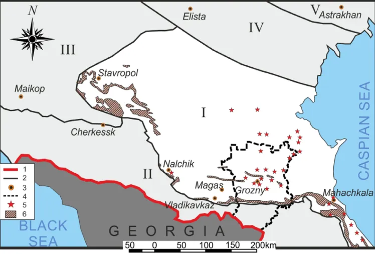
Ces gisements sont principalement situés sur le teritoire de la République de Tchétchénie, suivie par la région de Krasnodar, le Daghestan et le Kamtchatka.
Dès les années 20 au siècle dernier, une source d’eau géothermale a été découverte à l’emplacement du champ pétrolier Oktyabrsk en République tchétchène. Dans les années soixante-dix, l’Institut VNIPIgazdobycha a mené une exploration détaillée du gisement Khankala, situé à 10 kilomètres au sud-est de Grozny. Les prélèvements réguliers d’eau ont commencé en 1974, avec la mise en service de serres. Mais en 1994, du fait de la guerre sur le territoire de la République, l’exploitation du gisement Khankala a été arrêtée. En raison de ces événements tragiques, beaucoup de données sur le gisement géothermique ont été perdues et, pendant une longue période, l’eau a été utilisée et rejetée de façon primitive par la population locale [Farkhutdinov et al., 2014].
En 2013, le Grozny State Oil Institute, la compagnie ArenStroiCentr et le musée d’état de Vernadsky ont lancé, au sein du consortium “Ressources géothermiques” et avec
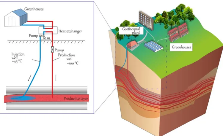
l’accompagnement scientifique du BRGM, un projet pilote de construction d’une centrale géothermique utilisant la couche XIII, la plus prometteuse du gisement géothermique de Khankala. La capacité de l’installation est de 5.45 Gcal/heure, utilisées pour faire fonctionner un complexe de serres. La station géothermale repose sur un système en doublet, constitué d’une boucle fermée, d’un puits de production et d’un puits de réinjection.
Bien que la Russie dispose de ressources importantes et démontrées en eaux géothermales, celles-ci sont peu utilisées. L’utilisation directe des eaux thermales, la production d’électricité et les domaines connexes ne sont pas bien développés. Il n’existe aucune installation géothermale autre que le site de Khankala reposant sur un système de doublet réinjectant 100% de l’eau utilisée. Tous les autres exemples russes connus d’utilisation d’eaux géothermales dans des bassins rejettent leurs eaux soit directement en surface, soit dans des aquifères superficiels. L’installation de Khankala a été mise en service avec succès début 2016; elle est destinée à fournir une expérience précieuse et à promouvoir une nouvelle phase d’exploration et de développement des ressources géothermales dans la région.
Chapitre 2. Description physiographique, géologique et hydrogéologique de la zone d’étude
Ce chapitre décrit la situation géographique, le relief, le climat et l’hydrographie de la République tchétchène. Son territoire couvre les pentes septentrionales du Grand Caucase ainsi que les steppes et plaines environnantes. Environ 35% du territoire de la République tchétchène sont occupés par des crêtes montagneuses, des vallées et des bassins séparant les massifs montagneux. Le reste du territoire est plat, le plus souvent marqué par un relief de collines.
Ces reliefs déterminent la direction d’écoulement des eaux souterraines du réservoir de Karagan-Chokrak, depuis leur zone de recharge dans les Montagnes Noires vers le Nord-Nord-Est. Les conditions climatiques, marquées par des précipitations abondantes, ainsi qu’un réseau hydrographique dense là où les niveaux réservoirs de Karagan-Chokrak
affleurent dans les Montagnes Noires, créent des conditions favorables pour l’alimentation en eau, avec le développement d’une ressource abondante au sein de ces couches. Les conditions climatiques entraînent un besoin de chauffage limité à 7 mois par an (d’octobre à avril), période durant laquelle les eaux géothermales sont utilisées pour le chauffage de serres. La situation hydrogéologique de la République de Tchétchénie est liée à sa situation au Sud-Est du Bassin artésien du Ciscaucase de l’Est.
La bonne perméabilité des niveaux du Karagan-Chokrak, un flux géothermique élevé, une lithologie et des structures tectoniques particulières, associés à la circulation hydrogéologique générale, ont permis une accumulation d’eaux géothermales au Miocène moyen dans ce bassin artésien. Les caractéristiques lithologiques du territoire – amincissement des couches productives du Karagan-Chokrak et diminutionde la teneur en argile du nord au sud et de l’est à l’ouest ont permis d’identifier les conditions hydrogéologiques les plus favorables dans le sud-est de la région. Pour cette raison, après une longue interruption dans l’utilisation des eaux géothermales dans la région, c’est le plus grand gisement de la République Tchétchène – Khankala, situé dans le sud-est de la région, qui a été choisi comme zone de développement prioritaire.
Chapitre 3. Analyse géostatistique du réservoir d’eaux géothermales de Khankala De nos jours, alors que les eaux géothermales constituent une forme d’énergie connue depuis longtemps, de nombreux chercheurs mettent en avant la question de la “durabilité” de l’exploitation du réservoir géothermique. Les techniques d’analyse reposant sur l’approche géostatistique et la modélisation numérique, qui ont été activement mises en œuvre dans de nombreux domaines scientifiques, constituent des outils efficaces pour l’évaluation de la ressource. Nous avons fait appel à l’analyse géostatistique (Chapitre 3) et à la modélisation numérique de la réinjection d’eau (Chapitre 4) afin de proposer des règles d’exploitation de la ressource de Kankala.
Analyse géostatistique et estimation de la cote de la couche XIII
La phase initiale du travail a consisté en une collecte de données. Une carte créée en 1967 a été utilisée à cette fin. Les coordonnées et les cotes absolues sont issues de cette
carte et réinterprétées en utilisant des méthodes géostatistiques. Dans ce travail, le krigeage universel a été utilisé.
La cote du toit de la couche XIII a été corrigée d’une dérive quadratique (1 x y x2 xy y2) afin de la rendre stationnaire. Le modèle de variogramme choisi est cubique avec une portée de 667 m et un seuil égal à 1084.3 m2. Un voisinage unique est retenu en raison de la faible quantité de données. Avant l’interpolation, les paramètres sélectionnés (modèle et voisinage) sont vérifiés par validation croisée: les données brutes sont “masquées” et réestimées, puis la différence entre les données originales et obtenues est calculée. La procédure de validation croisée montre que les paramètres sélectionnés fournissent une précision suffisante, qui se traduit par un coefficient de corrélation de 0.99. La carte structurale de la couche XIII a donc été créée en utilisant ce modèle.
Ceci est illustré par le remarquable accord entre cotes prédite et mesurée à l’occasion du forage du puits de production (erreur de 9 m, pour un écart-type de krigeage de 10 m)
Analyse géostatistique et modélisation de la distribution de température dans le réservoir géothermal de Khankala
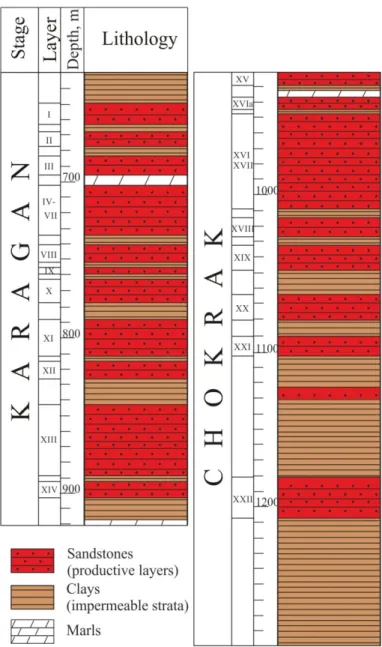
Des mesures de température dans les puits du réservoir de Khankala ainsi que des observations géologiques ont été faites en 1968 et 1988, et sont décrites dans les rapports [Shpak, 1968f; Krylov, 1988f]. Environ cent mesures ont été effectuées en tout dans quatorze puits productifs.
Les mesures de température montrent une croissance linéaire au début, puis un gradient plus faible lorsqu’on atteint les formations productives. Cela s’explique par le mécanisme de convection causé par la circulation des eaux géothermales. Pour cette raison nous avons choisi d’effectuer deux estimations reposant sur deux modèles différents.
Il a été décidé d’estimer la température à l’intérieur du réservoir en prenant le toit de la couche XIII comme base du plan de référence, puis de passer au plan de référence normal près de la surface. Les deux estimations ont enfin été combinées.
Une carte tridimensionnelle de la répartition de température au sein du réservoir géothermal de Khankala a été créée. La température de la couche XIII dans le puits de
production estimée par géostatistique est égale à 96.2 °C (écart-type de krigeage – 0.5 °C), la température réelle de l’eau à la tête du puits de production est de 95 °C.
La carte du toit de la couche XIII et le modèle 3D de répartition de la température dans le réservoir géothermal de Khankala ont été créés pour la première fois en utilisant des techniques géostatistiques. Ceci permet d’identifier les domaines les plus prometteurs pour les travaux futurs. La connaissance de la température ainsi que les informations sur le débit de production permettent une évaluation préliminaire de la capacité réalisable de la centrale géothermique.
Chapitre 4. Modélisation numérique
de l’exploitation de la ressource géothermale de Khankala
Une des étapes du travail, outré l’estimation géostatistique, est la simulation de la réinjection des eaux géothermales, afin d’établir des règles d’exploitation et de prédire l’évolution de la ressource. Ce travail de modélisation a été effectué en utilisant le code Metis [Goblet, 1980].
Modèle régional d’écoulement des eaux souterraines
La phase initiale du travail a consisté à créer un modèle hydrogéologique régional afin de comprendre les aspects généraux de la circulation de l’eau dans la couche XIII du gisement d’eaux géothermiques de Khankala, dans le vaste territoire de la République tchétchène. Comme la couche XIII est isolée des autres par des couches intercalaires imperméables, et du fait de la grande différence entre extensions horizontale et verticales, un modèle bidimensionnel a été adopté.
La zone de recharge du réservoir est l’affleurement des niveaux Karagan-Chokrak au sud de la Tchétchénie, au sein des montagnes Noires. Cette zone a été choisie comme limite sud de la zone modélisée. La frontière nord est la rivière Terek qui est supposée agir comme un axe de drainage régional. Le problème d’écoulement est décrit par deux lois: la loi de Darcy et la loi de conservation de masse (équation de continuité). Avant de modéliser la géométrie, les paramètres du système, les conditions initiales et les conditions aux limites ont été définies.
Ce modèle régional d’écoulement des eaux souterraines dans la couche XIII permet de calculer un débit d’eau de 0.62 m3/s à travers la frontière.
Modélisation du doublet géothermique implanté dans la couche XIII du réservoir de Khankala
Les résultats de la modélisation régionale des écoulements souterrains ont été pris en compte dans la simulation de la réinjection du doublet sous forme d’une composante d’écoulement régional superposée à l’écoulement créé par le doublet. Les résultats de l’estimation de la température et de la carte structurale de la couche productive XIII obtenus par application des méthodes géostatistiques sont utilisés d’une part pour créer le maillage, et d’autre part pour calculer les conditions initiales du système.
Les mécanismes d’écoulement d’eau et de transport de chaleur sont couplés: à chaque pas de temps, le programme effectue une résolution alternative des équations qui les décrivent. La durée simulée est égale à 50 ans.
Différentes hypothèses ont été examinées lors de la modélisation numérique:
– Influence de la distance entre puits de production et d’injection (450, 750, 1000 m).
– Perméabilité de deux zones de failles régionales. – Influence de l’écoulement régional.
Les résultats ont été comparés avec la solution analytique décrivant la variation de température au puits de production d’un doublet [Gringarten et Sauty, 1975]:
La suite de l’étude a consisté à simuler le comportement de récupération de la ressource de la couche productive Khankala XIII. On a supposé une durée d’exploitation de 50 ans (pour une distance entre puits de 450 m), à la suite de quoi le développement de la ressource a été arrêté.
Lorsque l’on prend en compte l’écoulement régional, la distribution initiale de température se reconstitue à 96.9% après 150 ans d’interruption de l’exploitation. En cas d’absence d’écoulement régional, le taux de récupération est de 75.7%.
recommandé de choisir une distance entre puits d’injection et de production égale ou supérieure à 750 m. Dans ce cas, la température au puits de production ne diminue pas drastiquement après 25–30 ans, durée au bout de laquelle les équipements de puits peuvent nécessiter un remplacement. Il convient de noter qu’il est important de positionner les puits selon un axe parallèle aux deux zones de failles en plaçant l’impact du puits de production au Sud et celui du puits d’injection au Nord, de telle sorte que l’écoulement régional ralentisse l’arrivée du front froid au puits de production.
L’un des principaux avantages du gisement géothermal de Khankala est qu’il s’agit d’un système multicouches. En cas de baisse significative de la température du puits de production après une certaine période d’exploitation de la couche XIII, il est possible de forer un nouveau doublet sur le même territoire, de manière à exploiter les ressources très prometteuses des couches IV-VII, XVI ou XXII, de sorte que la station géothermique pourrait continuer à fonctionner. La ressource de la couche XIII pourrait être utilisée à nouveau après un certain temps d’interruption, compte tenu de la vitesse relativement élevée de récupération de la température. D’une manière générale, on pourrait organiser l’utilisation périodique de différentes couches pour parvenir à une utilisation durable des eaux géothermiques du réservoir de Khankala.
Chapitre 5. Recommandations pour l’exploitation de la ressource géothermique de Khankala
Un dispositif d’extraction de la chaleur par doublet est utilisé sur le réservoir géothermique de Khankala. Ce choix a été effectué après avoir étudié l’expérience internationale, en particulier française, en matière d’exploitation des eaux géothermiques. Pour cette raison, lors de l’élaboration de recommandations pour une exploitation plus poussée du gisement de Khankala, une analyse comparative avec le bassin artésien de Paris a été utilisée.
Comparés aux eaux géothermales du bassin parisien, les gisements de la République tchétchène présentent les avantages suivants:
2. Faible salinité des eaux, ce qui signifie une corrosivité relativement faible. 3. Épaisseur relativement élevée de certaines couches productives.
On constate en revanche certains inconvénients:
1. De nombreuses couches productives n’ont été testées qu’en mode artésien, à des débits relativement faibles.
2. Les couches sont constituées de grès avec intercalaires et lentilles d’argile, ce qui peut nuire à l’injectivité.
3. La structure tectonique des dépôts est complexe, et affectée de zones de faille.
L’expérience réussie du développement du Bassin Artésien de Paris, depuis plus de 45 ans, permet d’anticiper les problèmes éventuels dans l’exploitation des gisements de la République tchétchène et de proposer des solutions. La création de cartes de température, de salinité, de répartition de la transmissivité, grâce à l’approche géostatistique, puis la simulation numérique de l’exploitation par modélisation mathématique, sont fortement recommandées (sous réserve de disponibilité des données) pour mieux comprendre les caractéristiques géothermiques de la République tchétchène. L’exploitation des eaux géothermiques de la République tchétchène nécessite une surveillance constante, des analyses chimiques et des mesures de la vitesse de corrosion et d’entartrage. Afin d’éviter la précipitation des bactéries, l’une des meilleures méthodes est de faire fonctionner les puits au débit le plus élevé possible. Le système multicouche du gisement d’eaux géothermiques de Khankala et la récupération relativement rapide du régime de température après arrêt de l’exploitation permettent de proposer l’installation de plusieurs doublets pour différentes couches productives, ce qui contribuera grandement à une utilisation durable.
Chapitre 6. Évaluation écologique et économique du projet de Khankala
Aspects écologiques
Le principal gaz à effet de serre émis par une station géothermique est le CO2
(90%), dont la quantité varie considérablement (en moyenne 122 CO2/Wh). Pour les
d’émissions de CO2 est proche de zéro. L’utilisation des eaux géothermiques de la couche
XIII sur le site de Khankala permet d’éviter l’émission de 7 000 tonnes de CO2 pendant la
saison de chauffage (7 mois), ce qui équivaut à la quantité de dioxyde de carbone émise par une chaudière gazière ayant une capacité similaire de 5.45 Gcal/heure.
En ce qui concerne les effets négatifs qui accompagnent l ‘exploitation du gisement de Khankala – pollution sonore, impact paysager, impacts physiques, pollution thermique et chimique, ils peuvent être surmontés à l’aide de technologies modernes, dont l’installation d’un système de circulation en doublet.
La technologie de doublet avec réinjection des eaux géothermales utilisées, ainsi que les méthodes modernes de surveillance et de gestion environnementale, peuvent résoudre le problème des conséquences négatives de l’exploitation des ressources du gisement de Khankala. Parallèlement, l’utilisation des eaux géothermiques, qui se substituent partiellement aux énergies traditionnelles, permet d’améliorer sensiblement les conditions environnementales régionales.
Aspects économiques
La station géothermique de Khankala n’a pas d’équivalent en Russie, donc l’investissement pour sa construction est augmenté du coût de la recherche et développement (R&D). Mais à l’avenir, il sera possible de fournir des services d’ingénierie pour l’installation du système de circulation géothermique (SCG), en réutilisant les résultats de cette première expérience, ce qui pourrait avoir un impact positif sur l’efficacité du projet et le retour d’investissement.
Les coûts de production de l’énergie thermique sont: les matériaux de base et auxiliaires (y compris les inhibiteurs), l’électricité, les salaires, les déductions de la masse salariale, la dépréciation des immobilisations, la réparation et la révision, les frais d’extraction des eaux souterraines et autres. Afin d’estimer l’efficacité commerciale de l’utilisation des eaux géothermiques au SCG, des indicateurs d’attractivité des investissements du projet ont été calculés. Du point de vue de l’efficacité sociale, le développement géothermique présente d’importants avantages. Il favorise la création de nouveaux emplois au cours de l’exploration, du forage et de la construction de centrales
géothermiques, ainsi que des emplois permanents avec le démarrage de l’exploitation de la centrale. Le soutien de l’Etat, y compris dans le cadre de la réglementation tarifaire, est nécessaire pour le remboursement des projets géothermiques, selon notre évaluation.
Pour la mise en œuvre de projets géothermiques en Russie, il existe un manque de cadre législatif et d’assurance spécifiques, dont notre pays n’a pas de pratique, contrairement par exemple à la France et à l’Islande, où le gouvernement a fortement soutenu le développement de ce type d’énergie de remplacement, compte tenu de sa durabilité et de son respect de l’environnement.
En cas de réussite du projet Khankala, il est possible que des travaux d’exploitation des 13 autres réservoirs de la République tchétchène soient mis en chantier, ce qui peut modifier le système local de consommation d’énergie et contribuer de manière significative à la stabilité économique de la région.
Conclusion
La Russie possède un potentiel reconnu et important de ressources en eau géothermique, mais aujourd’hui, seule une faible proportion est utilisée. Le projet Khankala est une nouvelle étape dans l’utilisation des eaux géothermiques dans le Caucase du Nord, car il est le seul exemple russe de station géothermique avec boucle fermée de puits de production et d’injection et 100% de réinjection du fluide utilisé dans le réservoir.
Parvenir à la durabilité dans le développement des ressources en eaux géothermiques nécessite une approche intégrée. Un rôle important dans la résolution des problèmes d’exploitation des eaux thermales peut être joué par l’analyse et l’estimation géostatistiques, ainsi que par la modélisation mathématique. La carte structurale ajustée de la couche XIII et une carte 3D de répartition de la température à l’intérieur du gisement Khankala sur la base du krigeage universel ont été créées. Ces cartes ont démontré l’importance du facteur structural-tectonique et du mouvement des eaux souterraines dans la mise en place de la température du territoire. La modélisation de l’exploitation des gisements géothermiques de Khankala a permis de prédire les évolutions de température, et de formuler des recommandations relatives à l’emplacement des puits
d’injection-production et à la distance entre les impacts au réservoir des forages, et enfin de fournir un scénario d’exploitation possible.
Le développement de l’utilisation des eaux géothermiques présente des avantages indéniables: respect de l’environnement et renouvelabilité. Afin de promouvoir ce domaine en République tchétchène, le soutien de l’Etat est nécessaire. Les problèmes sont l’absence d’un cadre législatif spécial et de systèmes d’assurance spéciaux. L’utilisation des quatorze dépôts reconnus en République tchétchène peut être une contribution importante à la production locale d’énergie et à la stabilité économique de la région, avec des avantages environnementaux liés au remplacement partiel des combustibles traditionnels.
Resume
Introduction
Recently, considerable attention in the world is given to the use of renewable energy sources, among them geothermal waters are of great importance due to ecological safety and economic efficiency of their use. Russia has large geothermal resources, but they are not practically used on an industrial scale. One of the most promising areas for geothermal waters is the Chechen Republic, which is at the 3 place among the Russian regions on approved operational reserves of geothermal waters deposits, the largest of which is the Khankala deposit.
The study of geothermal waters of the region using geostatistics and mathematical modelling is timely and relevant due to the steady growth of the needs of the Chechen Republic in the electricity and heat. The aim of this work – to determine the features of the Khankala geothermal waters deposit formation and identify the temperature change during exploitation.
Objectives of the study
1. Analyze the hydrogeological conditions of the area south-east of the East Ciscaucasian Artesian Basin and factors defining the spread of geothermal waters.
2. Create a map of temperature distribution within the Khankala geothermal waters deposit and structural map of the main productive layer.
3. Conduct mathematical modelling in order to predict temperature changes during exploitation of the Khankala geothermal waters deposit.
4. Make recommendations for further Khankala geothermal waters deposit exploitation.
Chapter 1. Geothermal development and research
(according to Russian classification). Development of their usage has more than a century history. The use of thermal waters as a source of energy began in the first half of the XIX century thanks to the development of thermodynamics, which allowed efficient direct use of the heat of hot water and steam and then even production of electricity. Russian current state on geothermal waters use and history of the Khankala deposit discovery and exploitation is considered. The initial development of geothermal energy began in two regions – Kamchatka and the Northern Caucasus. In the first case geothermal water was used to generate electricity, and in the second to produce heat.
To date, there are 66 explored deposits of geothermal waters in the Russian Federation, only 50% of these stocks is used for the production of 1.5 million Gcal of heat, which is equivalent to burning about 300 thousand tons of coal equivalent [Alkhasov, 2011].
The largest number of deposits is located on the territory of the Chechen Republic and then comes Krasnodar region, Dagestan and Kamchatka.
As back as in the 20s of the last century geothermal water source was discovered at the site of the Oktyabrsk oil field of the Chechen Republic. In the seventies, the VNIPIgazdobycha Institute conducted detailed exploration of the Khankala deposit which is located 10 kilometers southeast of Grozny. Regular water withdrawals started in 1974, when greenhouses were fully put into operation. But in 1994 because of the war on the territory of the Republic the exploitation of the Khankala deposit was stopped. Due to these tragic events a lot of data on the geothermal deposit were lost and for a long time water was used by local population in a primitive way with subsequent discharge [Farkhutdinov et al., 2014].
In 2013 Grozny State Oil Institute, LLC “ArenStroiCentr” and Vernadsky state geological museum within the consortium “Geothermal resources” and scientific accompaniment of the BRGM (“Bureau de recherches géologiques et minières”) started a pilot project to build a geothermal plant on the basis of the most promising XIII layer of the Khankala geothermal waters deposit of the Chechen Republic. Capacity of the facility is 5.45 Gcal/hour, with a greenhouse complex as a consumer. Geothermal station uses a
doublet system which is represented by a closed loop of one production and one injection well.
Despite the fact that Russia has large proven resources of geothermal waters they are not widely used. Thermal waters direct use, electricity production and related domains are not well developed. There is no geothermal plant with doublet circulating loop and 100% reinjection of used fluid, besides the Khankala station, all other known Russian examples of geothermal waters use in sedimentary basins are with subsequent discharge on the ground or into surface-water bodies. The Khankala station was successfully launched in the beginning of 2016 and it is supposed to provide useful experience and begin a new phase in the exploration and development of geothermal waters of the region.
Chapter 2. Physico-geographical, geological and hydrogeological conditions of the study area
In this chapter geographical location, relief, climate and hydrography of the Chechen Republic are considered. Its territory covers the northern slopes of the Greater Caucasus and surrounding steppes and plains. About 35% of the territory of the Chechen Republic is occupied by mountain ridges, valleys and intermountain basins. The rest of the territory is plain, mostly rugged by hills.
The land relief determines general conditions of the Karagan-Chokrak deposits groundwater flow from the recharge area in the Black Mountains to the north, north-east. Climatic conditions, abundant precipitation and densely-developed hydrographic network within the Karagan-Chockrak deposits outcrops in the Black Mountains are favorable for the aquifers supply and for the creation of significant natural groundwater resources. The climatic features have also identified the need for heating only 7 months of the year (from October to April) – the period during which the Khankala deposit geothermal waters used for greenhouses heating. Hydrogeological features of the Chechen Republic territory is defined by its location in the south-east of the East-Ciscaucasian Artesian Basin.
Favorable filtration parameters of the Karagan-Chokrak deposits, high heat flux values, lithology particularities, structural-tectonic factor and movement of groundwater
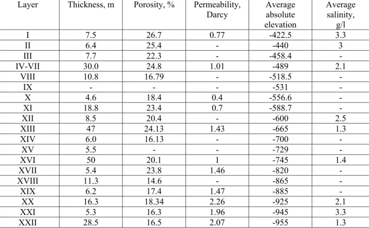
have caused content of the significant quantities of geothermal waters in the Middle Miocene hydrogeological stage within this artesian basin. The lithological features of the territory – a reduction in thickness of the Karagan-Chokrak productive strata and increase in clay content in the direction from south to north and from east to west, have identified the most favorable hydrogeological conditions in the south-east of the region. For this reason, as a priority for development after a long break in the use of geothermal waters the largest deposit of the Chechen Republic – Khankala was chosen, located in the southeast of the region. The thickness, consistency and transmissibility of the productive XIII layer distinguish it from the Chokrak-Karagan 22 aquifers of the deposit. It is one of the main factors together with relatively low depth for its selection as the heat source for geothermal station. Due to tectonic conditions the most favorable area for the location of the wells is a section of the axial zone of the anticline structure. Well bottoms in this case, will be located in the vicinity of the axis of the structure, which is determined by the minimum depth of the XIII layers top. Also they will be at the approximately maximum distance from the northern and southern faults, in order to avoid their possible impact on exploitation because the nature of the permeability of faults is not well-studied and the work in order to determine their conditions must be continued. The XIII layer average thickness is 47 m, transmissivity – 90 m2/day, salinity – 0.87-1.7 g/l, waters chemical composition is sodium-bicorbanate. The XIII layer is exploited by doublet circulation system with 100% reinjection of used fluid back in the aquifer.
Chapter 3. Geostatistical analysis of the Khankala geothermal waters deposit
Nowadays, when geothermal waters have been a well-known form of energy for a long time, many researchers put to the forefront the issue of “sustainability” of the geothermal reservoir development. The most effective methods of assessment are formed on the basis of geostatistical approach and numerical modelling, which have been actively implemented in all areas of science. Geostatistical analysis (Chapter 3) and computer modelling of water reinjection (Chapter 4) were used in order to establish guidelines for the Khankala deposit exploitation.
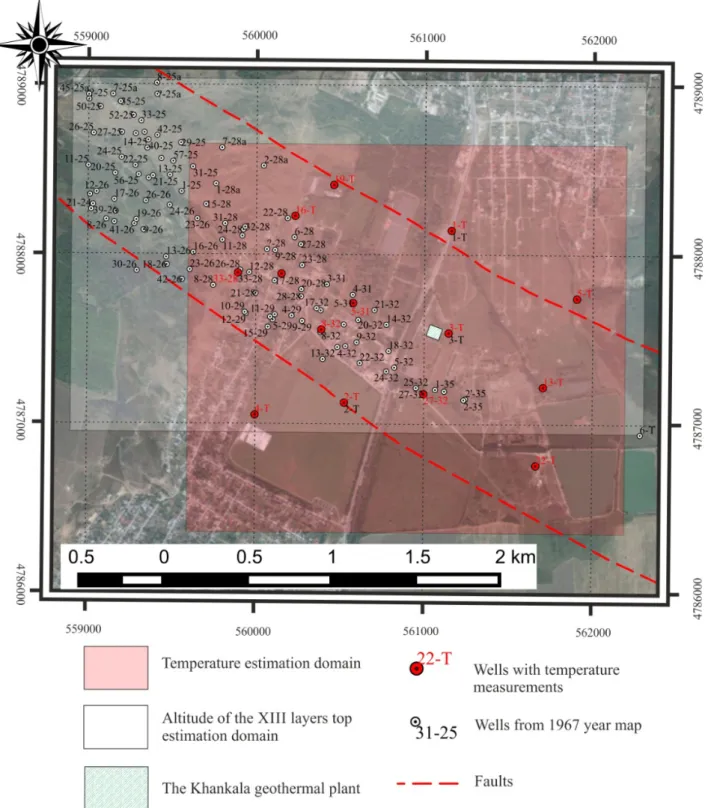
Geostatistical analysis and estimation of the XIII layer top elevation
The initial stage of the work was data collection. A map created in 1967 was used for this purpose. Coordinates and absolute elevations are taken from this map and reinterpreted using geostatistical methods. In this work universal kriging was used.
In order to bring the data the XIII layer top elevation to stationarity trend 1 x y x2 xy y2 was selected as the most appropriate. Chosen variogram model is cubic with the range equal to 667 m, and the sill equal to 1084.3 m2. Because of the small amount of data, unique kriging neighborhood is used. Before interpolation, the selected parameters (model and the neighborhood) are checked using cross-validation: raw data one after another is “hidden” and re-estimated and then the difference between the original and obtained data is calculated. Cross-validation procedure shows sufficient accuracy of the selected parameters with correlation coefficient of 0.99. Thus, the structural map of the XIII layer was created using this model.
The difference between the forecast and the actual depth after drilling the production well is 9 m (kriging standard deviation – 10 m).
Geostatistical analysis and modelling of temperature distribution within the territory of the Khankala geothermal waters deposit
Measurements of the temperature in the wells of the Khankala deposit as well as geological observations were made in 1968 and 1988, and they are reflected in the relevant reports [Shpak, 1968f; Krylov, 1988f]. About 100 measurements were made on the whole in 14 productive wells.
Temperature measurements show linear growth in the beginning but then as the depth reaches productive formations geothermal gradient tends to decrease. This can be explained by convection mechanism caused by geothermal waters circulation. It was the main reason to divide our estimation and use two different models.
It was decided to estimate the temperature within the reservoir taking the XIII layer top as the basis for the reference plane, and to switch to the normal reference plane closer to the surface, and finally to combine these two estimations.
geothermal waters deposit was created. The XIII layer temperature in the productive well according to geostatistical estimation is equal to 96.2 °C (kriging standard deviation – 0.5 °C), the actual temperature of water at the productive wellhead – 95 °C.
The XIII layer top structural map and 3D model of temperature distribution within the Khankala geothermal waters deposit were created for the first time using geostatistical techniques. It allows identifying the most promising areas for future work. Knowledge of temperature together with information on the productive flow rate provides preliminary assessment of the achievable capacity of geothermal power station.
Chapter 4. Numerical modelling
of the Khankala geothermal waters deposit exploitation
One of the stages of work, along with geostatistical estimation, is simulation of the utilized geothermal waters reinjection in order to draw up guidelines for the exploitation and to forecast the evolution of the resource. The computer code Metis was used for this purpose [Goblet, 1980].
Regional groundwater flow model
The initial stage of the work was the creation of a regional hydrological model in order to understand general aspects of water circulation in the XIII layer of the Khankala geothermal waters deposit within the vast territory of the Chechen Republic. The XIII layer is isolated from others by impermeable clay interlayers and a two-dimensional model was adopted for this case due to the big difference in horizontal and vertical extensions.
The reservoir recharge zone is the Karagan-Chokrak deposits outcrop in the south of Chechnya within the Black Mountains, which was chosen as the southern boundary of the modeled area. The northern border is the Terek River which is assumed to act as a regional drainage axis. This problem is described by two laws: Darcy’s law and the mass conservation law (continuity equation). Before modelling geometry, system parameters, initial and boundary conditions were defined.
This regional model of groundwater flow within the XIII layer of the vast territory of the Chechen Republic shows that liquid flow through the southern border is equal to 0.62 m3/s.
The Khankala deposit XIII layer doublet model
The results of regional groundwater flow modelling were taken into account as a regional flow component in the simulation of doublet reinjection. The results of temperature estimation and structural map of the XIII productive layer obtained after geostatistical methods application are used to calculate the initial conditions of the system and as a basis for creating mesh, respectively.
The processes of liquid flow and heat transport are coupled: at each time step the program conducts an alternate resolution of their equations. Simulation time is equal to 50 years.
Different hypotheses were checked during numerical modelling:
– Influence of the distance between production and injection well (450, 750, 1000 m). – Permeability of two general faults.
– Influence of natural groundwater flow.
The results were compared with the analytical solution for a doublet production well temperature change [Gringarten et Sauty, 1975].
Our further study was to simulate the recovery behavior of the Khankala XIII productive layer resource. The reservoir was assumed to be exploited for 50 years (the distance between the wells is equal to 450 m) and then development of the resource was stopped.
When natural groundwater flow is taken into account, the temperature will recover by 96.9% after 150 years of shut-down scenario. In case of no groundwater flow temperature recovers by 75.7%.
According to the results obtained by numerical modelling it is highly recommended to choose a distance between injection and production wells equal to 750 m or more. In such case the temperature in production well will not go down drastically after 25-30 years, the usual period of wells equipment lifetime after which its change may by required. It should be noted that it is important to place wells parallel to these two faults with production well bottom in the southern part and injection well bottom in the northern part in order to take into account natural groundwater flow direction which can slow down
expansion of cold front to production well.
One of the main advantages of the Khankala deposit of geothermal waters is that it is a multilayer system and in case of significant drop of temperature in production well after some period of the XIII layer exploitation, there is a possibility to drill a new doublet at the same territory on the resource of the highly promising IV-VII, XVI or XXII layers so the geothermal station could continue working. The resource of the XIII layer could be used again in case of shut-down after some period of time taking into account the relatively high speed of temperature recovery. In perspective, periodic use from different layers could be organized in order to achieve sustainable use of geothermal waters at the Khankala deposit site.
Chapter 5. Recommendations on the Khankala geothermal waters deposit exploitation
A doublet circulation heat extraction scheme is used at the Khankala geothermal waters deposit – decision taken after studying international, in particular French experience of geothermal waters exploitation. For this reason, when drawing up recommendations for further exploitation of the Khankala deposit, comparative analysis with the Paris Artesian Basin was used.
In comparison with geothermal waters of the Paris Basin, the Chechen Republic deposits have the following advantages:
1. The higher temperature of the fluid.
2. Low salinity of waters, which means relatively low corrosivity. 3. Relatively high thickness of some productive layers.
And also the following disadvantages:
1. Many productive layers have only been tested in artesian mode, at relatively low flow rates.
2. Layers are represented by sandstones with clay interlayers and lenses, which may adversely affect the injectivity.
Using the successful experience in the development of the Paris Artesian Basin for more than 45 years in the exploitation of the Chechen Republic deposits gives a great advantage and allows taking into account the possible upcoming problems and their solutions. A numerical simulation and creation of maps for temperature, salinity, transmissivity distribution using mathematical modelling and geostatistical approach is highly recommended (in case of data availability) for better understanding the Chechen Republic geothermal waters features, for highlighting the most promising areas and achieving sustainable use. One of the main possible problems to meet during exploitation is corrosion and scaling, and exploitation of the Chechen Republic geothermal waters needs constant monitoring, chemical analyzes and tests of the corrosion and scaling speed. In order to prevent precipitation of bacteria one of the best methods is to operate wells at the highest possible flow rate. Multilayered system of the Khankala geothermal waters deposit and relatively fast recovery of the temperature regime after exploitation stoppage allows proposing installation of several doublets for different productive layers which will be great contribution in achievement of sustainable use.
Chapter 6. Ecological and economic assessment of the Khankala project
Ecological aspects
The main greenhouse gas, emitted by geothermal station is CO2 (90%), the amount
of which varies considerably (on average 122 CO2/kWh). For binary geothermal power
plants with a closed loop, such as the Khankala, the amount of CO2 emissions are close to
zero. The use of the XIII layer geothermal waters at the Khankala station allows avoiding emissions of about 7 thousand tons of CO2 during heating season (7 months), which is
equivalent to the amount of carbon dioxide emitted by a gas boiler with similar capacity of 5.45 Gcal/hour.
With regard to the negative effects that accompany exploitation of the Khankala deposit – noise pollution, violation of the earth surface, physical impacts, thermal and chemical pollution, they can be overcome with the help of modern technologies, one of which is the installation of a doublet circulation system.
Doublet technology with reinjection of used geothermal waters along with modern methods of monitoring and proper environmental management can solve the problem of the negative consequences of the Khankala deposit resource exploitation. At the same time, the use of geothermal waters, partly replacing traditional forms of energy, makes it possible to significantly improve the regional environment conditions.
Economic aspects
The Khankala geothermal station has no analogues in Russia, so the value of the investment for its construction increased by the cost of research and development (R&D). But in the future there is a possibility of engineering services delivery for geothermal circulation system (GCS) installation, the replication of the results, what could have a positive impact on the efficiency of the project and return of investment.
The cost of production of thermal energy are: basic and auxiliary materials (including inhibitors), electricity, wages, deductions from payroll, depreciation of fixed assets, repair and overhaul, fee for the extraction of groundwater and others. In order to estimate the commercial efficiency of the geothermal waters use at GCS standard indicators of investment attractiveness of the project were calculated. From the standpoint of social efficiency geothermal development has important advantages. It promotes the creation of new jobs during exploration, drilling and construction of geothermal power plants, as well as permanent jobs with the start of plant operationing. The state support, including in the framework of tariff regulation is needed for the payback of geothermal projects according to our assessment.
For the implementation of geothermal projects in Russia areas of concern are the lack of a special legislative framework and insurance, of which our country has no practice, in contrast, for example, to France and Iceland, where the government strongly supported the development of this type of alternative energy, in view of its sustainability and environmental friendliness.
In case of the Khankala project success, it is possible that works on exploitation of the 13 others discovered deposits of the Chechen Republic will be started, which can change local energy consumption scheme and will be a significant contribution to
economic stability of the region.
Conclusion
Russia has confirmed high potential of geothermal water resources, but today only its small proportion is used. The Khankala project is new stage in use of geothermal waters in the Northern Caucasus as it is the only one Russian example of geothermal station with closed loop of production and injection wells and 100% reinjection of used fluid back into reservoir.
Achievement of the sustainability in geothermal waters resource development requires an integrated approach and an important role in solving the problems of exploitation of thermal waters belongs to geostatistical analysis and estimation, as well as mathematical modelling. The adjusted structural map of the XIII layer and a 3-D map of temperature distribution within the Khankala deposit on the basis of universal kriging were created, which have approved the importance of the structural-tectonic factor and movement of groundwater in the formation of the temperature regime of the territory. Modelling of the Khankala geothermal waters deposit exploitation allowed making prognosis of temperature changes, provided recommendation of injection-production wells location and distance between down holes and possible further exploitation scenario as periodic maintenance of different layers doublet systems.
Geothermal waters use development have undoubted advantages – environmental friendliness and renewability. In order to make this domain perspective in the Chechen Republic the state support is needed, issues are the lack of a special legislative framework and special insurance systems. Use of geothermal waters of the Chechen Republic 14 explored deposits can be a significant contribution to local energy production and economic stability of the region with environmental benefits of traditional fuels partial replacement.
Contents
Introduction ... 1 Chapter 1. Geothermal development and research ... 5 1.1. The world experience in the use of geothermal waters ... 5 1.2. The development of geothermal waters use in Russia ... 9 1.3. Russian geothermal potential... 11 1.4. History of the Khankala geothermal waters deposit development... 13 Chapter 2. Physico-geographical, geological and hydrogeological conditions ... 22 of the study area... 22 2.2. Climate and hydrography... 25 2.3. Stratigraphy... 26 2.4. Tectonic conditions... 32 2.5. Hydrogeological characteristics of the territory ... 36 and geothermal waters formation features... 36 2.5.1. The East Ciscaucasian Artesian Basin ... 36 2.5.2. The Khankala geothermal waters deposit ... 45 Chapter 3. Geostatistical analysis of the Khankala geothermal waters deposit... 54 3.1. The basics of geostatistical modelling... 54 3.2. Geostatistical analysis and estimation of the XIII layer top elevation ... 61 3.3. Geostatistical analysis and modelling of temperature distribution within the territory of the Khankala geothermal waters deposit... 69 Chapter 4. Numerical modelling of the Khankala geothermal waters deposit exploitation79 4.1. Regional groundwater flow model ... 81 4.1.1. Flow mechanisms ... 82 4.1.2. Conceptual model of the XIII layer... 85 4.2. The Khankala deposit XIII layers doublet model... 87 4.2.1. Flow and heat transfer mechanisms ... 87 4.2.2. Conceptual model of the reservoir ... 89
Chapter 5. Recommendations on the Khankala geothermal waters deposit further
exploitation ... 100 Chapter 6. Ecological and economic assessment of the Khankala project ... 107 6.1. Ecological aspects... 107 6.2. Economic aspects... 110 Conclusion... 115 Appendices ... 117 References ... 122
Introduction
Recently, considerable attention in the world is given to the use of renewable energy sources, among them geothermal waters are of great importance due to ecological safety and economic efficiency of their use. Russia has large geothermal resources, but they are not practically used on an industrial scale. One of the most promising areas for geothermal waters is the Chechen Republic, which is at the 3 place among the Russian regions on approved operational reserves of geothermal waters deposits, the largest of which is the Khankala deposit.
The Chechen Republic is located within the East Ciscaucasian Artesian Basin, hydrogeological, geothermal and hydro-geochemical conditions of which are reflected in the works of a number of researchers: I.G. Kissin, B.F. Mavritsky, F. A. Makarenko, A.I. Khrebtov, V.P. Krylov, G.M. Sukharev, I.S. Zektser, S.A. Shagoyants, M.K. Kurbanov, A.B. Alhasov and others. However, questions on the use of geothermal waters are not well studied, the work on the study and forecast of geothermal waters exploitation with the use of modern computer technologies are rare.
The study of geothermal waters of the region using geostatistics and mathematical modelling is timely and relevant due to the steady growth of the needs of the Chechen Republic in the electricity and heat.
Aim of the study
The aim of this work – to determine the features of the Khankala geothermal waters deposit formation and identify the temperature change during exploitation.
Objectives of the study
1. Analyze the hydrogeological conditions of the area south-east of the East Ciscaucasian Artesian Basin and factors defining the spread of geothermal waters.
2. Create a map of temperature distribution within the Khankala geothermal waters deposit and structural map of the main productive layer.
3. Develop a mathematical model for prediction of temperature changes during exploitation of the Khankala geothermal waters deposit.
exploitation.
Scientific novelty
It was shown that the most promising for the use of geothermal waters within the Chechen Republic are the Karagan-Chokrak deposits of the Middle Miocene, thermal resources of which were assessed. The structural map of the main productive layer of the Khankala geothermal waters deposit using geostatistical methods was created. Temperature distribution map within the study area was created. Modelling of the Khankala geothermal waters deposit exploitation with doublet circulatory system was conducted for the first time, changes in temperature during reinjection of water was estimated. The recommendations for the further hydrogeological work at the Khankala geothermal waters deposit were given.
Personal contribution
Personal contribution includes collection, analysis, interpretation and synthesis of the 1964-2009 years reports; estimation of reserves and calculation of thermal resources of the Middle Miocene Karagan-Chokrak deposits groundwater within the study area, creation of maps, including the structural map of the main productive layer and temperature distribution maps within the Khankala geothermal waters deposit; modelling of geothermal waters use in order to estimate changes in their temperature regime during the implementation of reinjection of used water and after exploitation; development of recommendations on the further exploitation of the Khankala geothermal waters deposit.
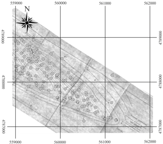
Material and methods
Archive materials were used: reports 1964–2009 from the archives of the Federal State Unitary Research and Production Enterprise “Russian Federal Geological Fund”; data field work and geochemical analyzes carried out in 2013 by the Grozny State Oil Technical University named after Acad. M.D. Millionshtchikov. The results of the hydrogeological and geochemical studies of 15 wells, 5 wells tests data of the Khankala geothermal waters deposit territory. Data processing was carried out in Microsoft Office Excel, mapping carried out using Isatis and CorelDRAW software. Calculations of groundwater regime temperature changes in the process of withdrawal and the subsequent
reinjection carried out on the basis of mathematical modelling using Metis code developed by Patrick Goblet [Goblet, 1980].
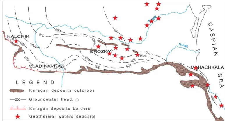
Fig. 1. Geothermal waters deposits of the survey area
1 – Khankala; 2 – Goity; 3 – Petropavlovsk; 4 – Germenchuk; 5 – Gunushki; 6 – Novogrozny; 7 – Gudermes; 8 – Central-Buruni; 9 – Chervleny; 10 – Komsomolsk; 11 – Shelkovsk; 12 – Novochedrinsk; 13 – Kargaly; 14 – Dubovsk.
Scientific and practical significance of the work
As a result of research, calculations and estimation of the Chechen Republic Middle Miocene Karagan-Chokrak deposits geothermal waters thermal resources were carried out, exploitation reserves of the Khankala geothermal waters deposit were counted. The zones of elevated temperatures on the territory of the Khankala deposit were allocated. The forecast of the use of thermal resources with the reinjection of used geothermal waters was given, the rate of
temperature recovery after exploitation is stopped was estimated and recommendations on the optimum exploitation parameters were made. Developed and adapted methods for estimating temperature, creating a structural map of the Khankala deposit productive layer, as well as mathematical modelling of reinjection can be used to justify the conditions of exploitation of geothermal waters deposits of the East Ciscaucasian Artesian Basin and other regions of Russia.
The aim of this work is to study and develop recommendations on the Khankala geothermal waters deposit exploitation on the basis of geostatistical analysis and computer modelling, as well as a comparative analysis with the Paris Artesian Basin.
Chapter 1. Geothermal development and research
1.1. The world experience in the use of geothermal waters
Geothermal waters are natural ground waters with temperature of 20 °С and more. Development of their usage has more than a century history. The use of thermal waters as a source of energy began in the first half of the XIX century thanks to the development of thermodynamics, which allowed efficient direct use of the heat of hot water and steam and then even production of electricity.
One of the first examples of the use of geothermal waters is Larderello (Tuscany, Italy). There geothermal waters obtained either naturally or from wells were used for energy purposes at the beginning of the XIX century. Boron rich water from underground sources was used to produce boric acid. Initially, it was obtained by evaporation in iron boilers, heated with wood. In 1827 Francesco Larderel, a pioneer in the production of boron, built the first plant to produce heat from geothermal energy and created a system that worked on heat of waters. The geothermal source was covered with a brick dome, inside which there was the low-pressure steam boiler, heated by geothermal waters. The heat was used for evaporation of boron from saline water and additionally for pumps and other equipment operation. A little later, in 1904, at the same place in Larderello Italian scientist Piero Ginori Conti invented the prototype of the generator in which thermal steam was a source of electricity. In 1913, this geothermal station began to work and produced 250 kW of electricity, and by 2013 the amount of produced electricity was estimated as 545 MW, representing 1.6% of the total in Italy [Stober, Bucher, 2013].
Along with the development of technologies for the use of high temperature geothermal waters to produce electricity there was an extension of the use of medium and low temperature geothermal waters for heat supply.
In 1890, the first systematic work on the use of geothermal heat (68–80 °C) was completed in Boaz (Idaho, USA), which led to the creation of the heating system based on thermal waters. Later, in 1900, a similar system was installed in Klamath Falls (Oregon, USA), where in 1926 it began to be used for heating greenhouses [Stober, Bucher, 2013].
Japan (1919), Iceland (1928), New Zealand (1958), Mexico (1959). For example, in Iceland development of geothermal waters use reached broad scope, by 2011 about 90% of houses were heated and 27.3% (4701 GW/h) of the total amount of electricity was produced [Ingimarsson, 2012].
Since 1965, geothermal waters of medium temperature (66–90 °C) have been actively used in France, particularly in the Paris sedimentary basin, in order to produce heat. Establishing of doublet technology (closed loop of one injection and production well) allowed to achieve stability in flow rates and to avoid harm to the environment (the primary plan for discharging water into the Seine River had to be canceled due to high salinity 2–35 g/l) [Lopez et al., 2010].
The use of low-temperature geothermal resources became possible due to the invention of heat pumps in 1852 by Lord Kelvin. Later, in 1912, Heinrich Zoelly patented their application to produce heat from near-surface geothermal waters (< 30 °C). They were first used successfully in 1940, in Indianapolis (State of Philadelphia, USA) and Toronto (Canada) [Stober, Bucher, 2013].
To date, 24 countries are exploiting geothermal waters to generate electricity, 12,635 MW in total and more than 70 countries to produce heat [Fridleifsson et al., 2008; Holm et al., 2010; Matek, 2013].
Giant potential of geothermal resources is confirmed by the data from the UN Department of Economic and Social Affairs, the World Energy Council and others [Boguslavskiy, 2013]. However, only 3.5% of the world’s geothermal potential is used for electricity production and 0.2% for heat supply [Alkhasov, 2006].
Recently, technological parameters needed to assess the possiblity of the practical use of geothermal waters are being added in their classification in connection with the expansion of the geothermal market [Williams et al., 2011]. Possibilities of geothermal waters use according to different temperatures are summarized in the following diagram [Povarov, 2003] (Figure 1.1).
Fig. 1.1. Geothermal waters of different temperatures use [Povarov, 2003]
There has also been a sharp increase in volumes and the expansion of areas of use of geothermal resources (Table 1.1., Table 1.2).
Table 1.1. Total worldwide installed capacity from 1995 up to end of 2015 and short term forecasting for continent [Bertani, 2015]
Installed in 1995 Energy in 1995 Installed in 2005 Energy in 2005 Installed in 2015 Energy in 2015 Forecasting for 2020 Country MW GWh MW GWh MW GWh MW Europe 722 3881 1124 7209 2133 14821 3385 Africa 45 366 136 1088 601 2858 1601 America 3800 21303 3911 25717 5089 26353 8305 Asia 1980 10129 3.290 18903 3756 22084 6712 Oceania 286 2353 441 2792 1056 7433 1440 Total 6832 38032 8.903 55709 12635 73549 21443
In the period from 2005 to 2010, the production of electricity on the basis of geothermal waters in Russia has increased by 419% [Bertrani, 2010]. It happened as a result of the development of this alternative energy in Kamchatka and the Kuril Islands.
Table 1.2. Examples of countries installed capacity and produced energy from geothermal resources [Bertani, 2015]
Installed
in 2010 in 2010 Energy Installed in 2015 in 2015 Energy Forecast for 2020 Increase since 2010 COUNTRY
MWe GWh MWe GWh MWe MWeGWh Capacity
% Energy % China 24 150 27 150 100 3 12% Costa Rica 166 1131 207 1511 260 42 380 25% 34% France 16 95 16 115 40 20 21% Germany 6.6 50 27 35 60 20 -15 280% -30% Iceland 575 4597 665 5245 1300 90 648 16% 14% Indonesia 1197 9600 1340 9600 3500 143 12% Italy 843 5520 916 5660 1000 74 140 9% 3% Japan 536 3064 519 2687 570 -16 -377 -3% -12% Kenya 202 1430 594 2848 1500 392 1418 194% 99% Mexico 958 7047 1017 6071 1400 59 -976 6% -14% New Zealand 762 4055 1005 7000 1350 243 2945 32% 73% Philippines 1904 10311 1870 9646 2500 -34 -665 -2% -6% Russia 82 441 82 441 190 Turkey 91 490 397 3127 600 306 2637 336% 539% USA 3098 16603 3450 16600 5600 352 11% Total worldwide 10897 67246 12635 73549 21443 1738 6303 16% 9%
At the same time, according to the table 1.2 in the period from 2010 to 2015 there was no growth in electricity production from the use of geothermal waters in Russia. Worldwide geothermal waters direct use increased as well (Table 1.3).
Table 1.3. The direct use of geothermal waters in 2010 (first 20 countries by the number of energy used per year are listed) [Lund et al., 2010]
Country Capacity, MW Annual use (2010),
TJ/year GWh/year Annual use (2010), 1 2 3 4 China 8898 75348.3 20931.8 Usa 12611.46 56551.8 15710.1 Sweden 4460 45301 12584.6 Turkey 2084 36885.9 10246.9 Norway 3300 25200 7000.6 Iceland 1826 24361 6767.5 Japan 2099.53 15697.94 7138.9 France 1345 12929 3591.7
1 2 3 4 Germany 2485.4 12764.5 3546 Holland 1410.26 10699.4 2972.3 Italy 867 9941 2761.6 Hungary 654.6 9767 2713.3 New Zealand 393.22 9552 2653.5 Canada 1126 8873 2464.9 Finland 857.9 8370 2325.2 Switzerland 1060.9 7714.6 2143.1 Brazil 360.1 6622.4 1839.7 Russia 308.2 6143.5 1706.7 Mexico 155.82 4022.8 1117.5 Argentina 307.47 3906.74 1085.3 Total 50583 438071 121696
The prospect and expediency of geothermal waters development is justified by the following advantages of geothermal resources in comparison with traditional sources of energy: renewability, proximity to the customer, the possibility of full automation, security of production, economic competitiveness, the possibility of building low-power facilities and environmental friendliness [Kagel, 2007]. However, their specificity includes a number of disadvantages: dispersion of the sources, limited experience in industrial applications, low temperature capacity of coolant, problems with transportation, storage difficulties, lack of special legislative framework and insurance systems [Boguslavskiy et al. 2000; Boguslavskiy 2004, 2010].
In 2012, the International Agency for Renewable Energy (IRENA) and the International Energy Agency (IEA) launched the joint development of a database on renewable energy policies of countries and measures to develop geothermal energy [Cherkasov et al., 2015]. Researchers estimate that by the end of the XXI century the share of geothermal resources in the energy balance of the world economy will be from 30 to 80% [Huttrer, 2000; Lund, Freeston, 2000].
1.2. The development of geothermal waters use in Russia
![Table 1.2. Examples of countries installed capacity and produced energy from geothermal resources [Bertani, 2015]](https://thumb-eu.123doks.com/thumbv2/123doknet/2885638.73472/36.892.82.839.161.615/examples-countries-installed-capacity-produced-geothermal-resources-bertani.webp)