HAL Id: hal-02343673
https://hal-univ-rennes1.archives-ouvertes.fr/hal-02343673
Submitted on 3 Nov 2019
HAL is a multi-disciplinary open access
archive for the deposit and dissemination of
sci-entific research documents, whether they are
pub-lished or not. The documents may come from
teaching and research institutions in France or
abroad, or from public or private research centers.
L’archive ouverte pluridisciplinaire HAL, est
destinée au dépôt et à la diffusion de documents
scientifiques de niveau recherche, publiés ou non,
émanant des établissements d’enseignement et de
recherche français ou étrangers, des laboratoires
publics ou privés.
To cite this version:
Marie-Yvane Daire. Islands and archaeological research in Western France. Shima : The International
Journal of Research into Island Cultures., Shima Publishing, 2009, 3 (2), pp.52-69. �hal-02343673�
________________________________________________________
ISLANDS AND ARCHAEOLOGICAL
RESEARCH IN WESTERN FRANCE
Une très longue histoire d'amour
MARIE-YVANE DAIRE
Centre National de la Recherche Scientifique, Université de Rennes <[email protected]>
Abstract
The Brittany region corresponds to the largest peninsula of France, including hundreds of isles and small islands. Almost all of these islands contain remains of ancient human occupation dating from Prehistoric times and historical periods: megalithic monuments, Neolithic and Metal Ages settlements, Stone Age tool deposits, pre-Roman salt production workshops, early Christian hermitages and chapels, fish traps built at various periods, and so on. This paper aims to present a collaborative research project dedicated to island archaeological research in Western France. The geographical, cultural and historical background throws light on the genesis and development of the collaborative research carried out over the past two decades by the AMARAI Association1; the objectives, methods, content and main results of the research projects
are summarised, along with a short presentation of the plans and prospects that aim at opening up new perspectives on coastal and island archaeology in Western France. Keywords
Archaeology, islands of Western France, heritage, environments, sea level, vulnerability Introduction
The interest of archaeologists in island, coastal and maritime environments is not a new phenomenon but currently seems to be increasing worldwide (Rainbird, 2007), as reflected by the recent development of international journals such as the Journal of
Island and Coastal Archaeology (first published in 2006) and the Journal of Maritime Archaeology (also first published in 2006). In this general context, island archaeology
seems to play a specific role and generate interest, probably because this approach deals with some of the main anthropological concepts such as isolation, remoteness and interaction (Fitzpatrick and Anderson, 2008). Moreover, such studies address fundamental questions such as interactions between humans and the environment, cultural integration, contacts between human groups or goods distribution in past centuries, as well as understanding the development of island societies and their relation to mainland cultures (Shima Editorial Board, 2007: 1). As Fitzpatrick and Erlandson identify, present research:
________________________________________________________
reflects the growth in scholarly interest in the long and dynamic history of human settlement in coastal and island settings… The growing interest in island, coastal, and maritime societies is linked to the question [of] how aquatic environments have affected (and oftentimes directed) the course of human evolution, culture and history. (2007: 1-2)
Clearly influenced by the general development of “Nissology” (McCall, 1994), an original initiative has emerged over the past 20 years focusing on the island heritage of Western France. The origin and development of this collaborative research can be explained, on one hand by the geographical and cultural environments that conditioned research issues in the region and, on the other, by the long-established attractiveness of Breton islands for archaeologists.
This article first presents the methodological and scientific objectives of the project, followed by a summary of the most significant advances made during the past 20 years. However, the purpose of this study is not to review the numerous past and present results of island archaeological research, since even an encyclopaedia would be insufficient for this purpose; some bibliographical references and web site addresses are given below so the interested reader can go into the subject in more detail.
1. The island heritage of Western France: a geographical and cultural context
‘Islandscapes’ in Brittany
The geographical and environmental conditions of Western France are dominated by an oceanic influence, with the coasts of Brittany exhibiting various landscapes such as granite cliffs, dunes, sandy beaches, estuaries and marshlands. Hence, it is not surprising that coastal areas as a whole have been widely and intensively settled in past times. Schematically, the attractiveness of this coastal zone can be explained mainly in terms of its equable climate, variety of resources and openness towards overseas contacts, with nuances according to the period and cultural context considered. Nowadays, 95% of the population of Brittany lives less than 60 km from the coast. With 1770 km of coastline and 850 offshore isles and small islands, the Brittany peninsula offers an exceptional potential for scientific studies of islands, which are very well documented in the discipline of coastal and island archaeology (Figure 1). Systematic research carried out on the numerous islands of Brittany has revealed a potential of more than 700 archaeological sites dating from earliest Prehistoric times up to the end of the Dark Ages, corresponding to various cultural significations: rock shelters and camps from the Palaeolithic period (more than 550 000 BP), then from the Mesolithic period (about 8000 BP), Neolithic graves (from 7000 up to 4000 BP), Bronze Age and Iron Age settlements (4000 to 2000 BP), Roman villas, hermitages and medieval monasteries.
The 850 islands of Brittany form two heterogeneous groups, which are highly contrasted in terms of geographical setting, size, remoteness and location. Half of them are offshore islands, including the larger isles (Ushant, Sein, Hoedic, Houat, Belle-île, Groix and Batz) and some archipelagos (Bréhat, "les Sept-îles", Molène and Glénan, as well as the islands in the Morbihan Gulf). The other group consists of small islets located very close to the continent or belonging to archipelagos, with surface-areas of generally
________________________________________________________
less than 1 hectare. Since they are only separated from the mainland by some hundreds of metres, they can be regarded as “temporary” or “satellite” islands, cut off only by the high tide but more or less accessible at low tide (Brigand, 2002).
Figure 1: Location maps of the study area and the main sites mentioned in the text (Map by M.Y. Daire and L. Quesnel).
This coastal landscape is diversified, resulting from continuously evolving conditions during the Pleistocene period (circa -2 Million Years) when the volume of the oceans varied according to climatic changes. During the cold phases of the Pleistocene, there was no seawater between France and England, while, in Southern Brittany, the
________________________________________________________
shoreline shifted 70 km South of its present-day position. The water frozen during these cold phases was released back into the oceans during warmer periods, leading to a rise in sea level (Tooley and Shennan, 1987). In this way, most of the present-day islands did not exist as such at the beginning of the Holocene but only formed hills rising above coastal valleys. Thus, when Prehistoric peoples decided to settle at the Goareva rock shelter (south of the Bréhat main island), circa 40 000 BP, they could travel from the mainland and cross the wide valley without getting their feet wet! During the Palaeolithic period, human groups could easily reach Groix Island owing to low sea level during cold phases, as recently demonstrated by the archaeological record (Molines et al., 2004). During the Holocene period, the sea level rose at an irregular rate. The general scientific consensus today maintains that, at the end of the Mesolithic (5th millennium BC), the shoreline was 10 m lower than at the present level. Due to the sea-level rise, the large islands of Brittany became progressively separated from the mainland; the Houat-Hoedic islands complex, joined together at this time, had a larger land area (4-6 times more) but were separated from the Quiberon peninsula and the Continent.
The megalithic monument builders of the Neolithic period systematically erected monumental collective graves on the top of coastal hills (islands to be), as illustrated by the islands of Bono or Guennoc on the northern coast, and the monuments on Ile aux Moines and Gavrinis in Southern Brittany. During subsequent periods of recent Prehistory (Bronze and Iron Ages, then Antiquity and the Middle Ages), the maritime landscape shows less important differences compared to the present-day situation. The average rise in sea level, evaluated at 2 m since the end of the Iron Age (2nd-3rd centuries BC), gradually completed the cutting off of numerous small islands, although the situation was sometimes moderated by local conditions.
Once upon an island
The Gavrinis monument has always been considered as an established component in the Morbihan landscape. From the 16th Century it is mentioned by navigators/sailors as a remarkable and useful sea mark (Figure 2). In fact, the islands of the ancient ‘Armorica’ were mentioned by ancient authors and navigators as early as the first millennium BC. The Carthaginian Himilcon visited the “Dark western Ocean” (Atlantic Ocean) and reached the western coasts of Europe during the 5th Century BC, and was followed by Pytheas from Massilia (4th century BC; four centuries later, the Greek writer Strabo (1st century BC-1st Century AD) made use of their accounts and recognised the “Uxisama island” (identified as Ushant Island) as the farthest territory off the Gabaïon Cape. During the 1st Century AD, Pliny the Elder mentions this Island as “Axantos” and, three centuries later, it is cited as “Uxantis” in the ‘Antonin Maritime Itinerary’ as well as five other islands off Brittany: “Sicdelis” in the English Channel approaches, identified as the Scilly Islands, and on the Southern coast of Brittany “Siata”, “Arica”, “Vindilis” (Belle-Île and perhaps also the other “Venetic” islands, including Groix, Houat and Hoedic) and “Sina” (Sein Island).
Furthermore, it so happens that some ancient authors mention the peopling of islands when describing the religious life and temples of their contemporary Celtic tribes of Western Europe (Cunliffe, 2001; Cougny, 1986). A small island was evoked by several ancient Mediterranean writers, such as Posidonios and Strabo, (see Cougny 1986) probably located near the mouth of the river Loire. It was said to be inhabited by the “Samnites” priestesses worshipping Dionysos or Bacchus, and no man was allowed to
________________________________________________________
set foot there. Strabo and Pomponius Mela (1st Century AD) mentioned another island (probably Sena Island) in the vicinity of Brittany, where religious ceremonies were held in honour of Demeter and the goddess Koré, according to rites comparable to those performed at Samothrace temples; the priestesses were said to be hugely powerful, able to raise tempests by their incantations, to transform themselves into animals, to cure incurable diseases, and to tell the future.
Figure 2: Gavrinis island: passage grave drawings (postcard from the early 20th Century).
Some of the larger islands off the Northern coast of Brittany (eg Batz island or Bréhat archipelago) seem surprisingly absent from the ancient writings mentioned above (perhaps because these travellers followed a more Northern route) and they only appear in the literature between the 9th and the 11th centuries. In 1154, the Arabic geographer Al
________________________________________________________
Waters of this sea are deep and of dark colour… sailing in this ocean is very difficult, winds are raging and, to the West, limits are unknown. In this Ocean, there exist quantities of inhabited islands. Few navigators dare to venture there. (quoted in Bresc, 1999: 197)
These very ancient references to the Armorican Islands show the great importance of these remarkable points of the coastal landscape for the sailors and navigators of early Antiquity. The islands and their surrounding seas were also rich grounds for the building of legends; however, recent archaeological evidence about the existence of island sanctuaries in Western France shows that such legends are probably founded on true past events, as indicated by the discovery of several Iron Age sanctuaries on Breton islands (Ushant, Ebihens, etc.).
2. Islands and archaeological research: a long romance. Islands and archaeologists: a mutual attraction
In the marine landscape of Brittany, islands are nowadays often considered archaeological reserves, allowing a wide range of research due to the generally well preserved nature of the remains. Isolation or access difficulties often serve as a
protection against modern threats such as intensive agriculture, concentrated building or tourism infrastructure. The absence of ploughing is an important advantage for the preservation of archaeological remains, since this activity is a major cause of surface destruction of archaeological levels in farming areas. Small islands are especially useful in this respect as they have scarcely been populated or cultivated in modern times. The preservation of island archaeological heritage is often reinforced when islands or archipelagos acquire the status of a Nature Reserve; this type of legal protection procedure (existing since the 1920s) has a positive direct effect not only on the biotope but also on heritage preservation, by limiting anthropic activities and restricting access. Such nature reserves exist in the Sept-Îles and Molène Iroise Nature Reserve archipelagos on the Northern coast of Brittany, as well as in the Glénan (Saint-Nicolas nature reserve) and Morbihan Gulf archipelagos on the Atlantic coast. In the case of the larger islands, the nature reserve status covers one or several selected areas, such as the “François Le Bail” mineralogical nature reserve on Groix island (divided into two zones (of 4 and 43 hectares), or the Koh Castell nature reserve on the windward coast of Belle-Île, which is also an archaeological complex (Iron Age cliff castle) at present hosting thousands of protected marine birds.
However, in view of the general context, this apparently ideal situation is offset by the fact that coastal zones, as a whole, including the isles and small islands, are increasingly affected by current climatic changes and relative sea-level rise, which lead to coastal erosion. This erosion affects not only the natural environment but also the archaeological heritage (monuments, ruins, ancient shell middens, artefact deposits, tombs, etc) threatened with disappearance without any hope of recovery. For example, during the storm of 10th March 2008, the northern beach of Triélen Island retreated 4 m in
some places, with vast consequences for the archaeological Iron Age site, as the deposit lost several cubic metres in one night. The assessment of the vulnerability of coastal and island heritage also includes the effects of some anthropic pressure, eg direct consequences of cleaning up oil slicks (eg Amoco Cadiz in 1978, Erika in 1999), as mechanical diggers often (unwittingly) damaged remains or monuments located on
________________________________________________________
the seashore. Numerous island archaeological sites are thus threatened by more or less rapid destruction, accelerated by the relative rise of sea level, erosion, and modifications of the environment. Thus, the vulnerability of coastal and island areas has to be established to assess the impact on heritage, allowing us to study the threatened sites before their complete destruction, and propose solutions (material protection) where possible. The rich heritage of these islands, combined with their evident vulnerability, has long drawn the interest and awareness of archaeologists.
The historical background
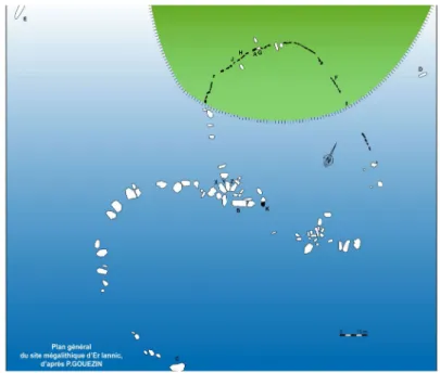
It is currently accepted that scientific research on the islands of Western France arose from the expeditions of archaeologists and naturalists (Brigand, 2002). From the early 19th Century, several ‘antiquarians’ started to explore these islands, including clergymen, doctors and teachers who were mainly interested in the monumental remains (megalithic monuments). They began their exploration on the larger islands of Brittany (such as Belle-Île-en-Mer, Groix, Ushant, etc.), since these were populated and were more easily reached thanks to the help of the local population providing transport by boat. However, the antiquarians quickly turned their attention to small islands, especially those grouped in archipelagos (such as Molène or in the Morbihan Gulf). Between 1865 and 1920, these pioneer archaeologists discovered and described sites on 26 islands in Brittany. This first period corresponds to the predominance of the general interest for Neolithic monumental remains, both on islands as well as on the Continent. The doctor G. de Closmadeuc (1828-1918) bought Gavrinis island in the Morbihan Gulf so he could explore and repair (or rebuild) the famous Neolithic passage grave. Close to this island, he discovered the stone circles of Er Lannic, partly submerged (Figure 3), and went on to raise the question of landscape evolution and sea-level changes. In 1901, P. Du Chatellier published an inventory of island monuments in the department of Finistère (Ushant, Molène archipelago and several small islands) and carried out some excavations (eg on the Neolithic monuments of Melon island). During the period 1897-1918, the Captain L. Le Pontois compiled an inventory of the megalithic monuments of Groix Island, sometimes assisted by P. du Chatellier, and explored some of the sites, while the Abbot Lavenot spent several years exploring the heritage of the Houat and Hoedic islands.
Amongst these pioneers, we should mention Marthe and Saint-Just Péquart, owners of an ironmongery business from Lorraine, who first discovered the Breton heritage thanks to Zacharie Le Rouzic. Between 1923 and 1934, they carried out several surveys and excavations on the islands and small islets of Southern Brittany (Moutons, Er Yoh, Hoedic and Teviec). As they were the first French archaeologists to formulate the scientific interest of studying the heritage of islands formerly linked to the continent, they can be considered the pioneers of modern island archaeology in the area of Western France. Their excavations of the Mesolithic cemeteries of Teviec and Hoedic are still regarded as unequalled examples in the discipline (Figure 4). Moreover, they quickly developed an interest in the new image technologies of the day (photography and moving pictures), thus leaving us with an abundant iconography and documentation of remarkable quality (Large, 2007).
________________________________________________________
Figure 3: Er Lannic prehistoric standing stones circles, partly submerged (after Gouezin, 1998)
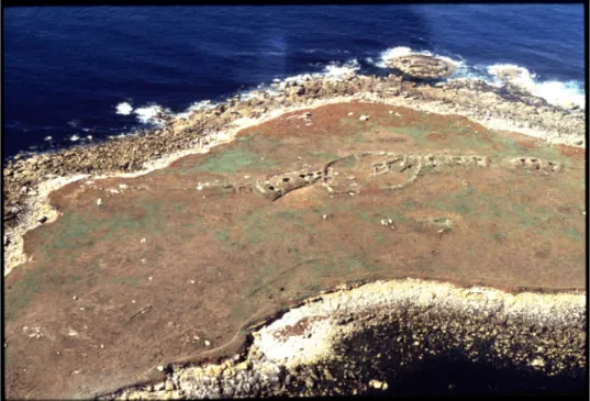
During the following decades, islands were relatively neglected by French scientists. With the main interest of archaeologists turning to fortified Celtic settlements, Sir Mortimer Wheeler explored most of the hillforts of Northern France, including those of the islands of Southern Brittany. His study of Koh Castel (the so-called ”Caesar’s camp”) on Belle-Ile-en-Mer, a Gaulish settlement dating from the last decades before the Roman Conquest, remains today the only dataset on this major site (Wheeler and Richardson, 1956). Equally, the exploration of the Camp de Kervedan on Groix Island by Leslie Murray Threipland (1936) still represents a unique source of documentation about this important cliff castle. From the 1950s onwards, and during the thirty year leadership of Pierre-Roland Giot, members of the Anthropological Laboratory of the University of Rennes conducted several excavations on small island sites belonging to various cultural contexts: the megalithic monuments on the small islands of Carn and Guennoc in Finistère (Figure 5), the Gavrinis passage grave, the Palaeolithic camp of Plassen-al-Lom in Bréhat main island, as well as the Roman villa and the Early medieval monastery of Lavret island in the Bréhat archipelago (Giot, 1982).
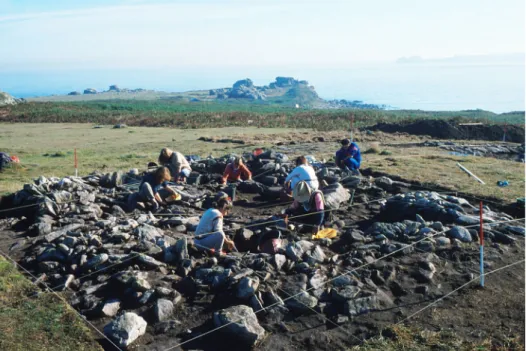
In the 1980s, owing to the dynamism of several research projects, excavations programmes developed in parallel on the Bronze and Iron Age site of Mez Notariou, Ushant Island (Le Bihan ed, 2001), the Bronze Age settlement of the small island of Grande Roche in the Baie de Saint-Jacut, the Gaulish village of Les Ebihens main island (Langouët ed, 1986), the Gavrinis passage grave (Le Roux, 1885) and the pre-Roman hamlet of Yoc’h island (Daire, 2001) (Figure 6).
________________________________________________________
Figure 4: Mesolithic burial on Hoedic Island (Brittany) excavated by M. and S. Just Péquart 1931-1934 (Drawing by D. Ladiray, Collection Melvan ©Muséum
national d’histoire naturelle).
Figure 5: Aerial view of the megalithic burials and Gaulish settlement on Guennoc Island (photo by M.Y. Daire).
________________________________________________________
The archaeologists involved in these island research projects thus became aware of the need to develop a common approach in discussing the methodological, technical, and scientific problems specific to island archaeology. The AMARAI (Association for the development of Channel and Atlantic islands archaeological research) was then set up in 1988, providing a flexible structure able to bring together professional researchers as well as volunteer collaborators, sharing the same interest in the island heritage of Western France. The strength of this organisation is that it builds up a research network, establishing connections between researchers, authorities, local cultural groups, and environmental managers, interested in islands.
It is only since 2000 that the official institutional structure UMR 6566 CReAAH (Mixed Research Unit depending on CNRS, Universities of Rennes 1, Rennes 2 and Nantes, Ministry of Culture and INRAP created a specific research programme dedicated to coastal archaeology in Western France. This Unit has close links with AMARAI, with several researchers belonging to both organisations, and pursuing common targets, such as:
- evaluating the evolution of coastal landscapes (Quaternary sea-level and climate changes, shoreline variations), and its impact on human peopling in the past as observed on a long timescale;
- understanding human adaptation strategies and cultures in regard to palaeogeography and environment;
- analysing the rules of exploitation of diversified marine and coastal resources (mineral, vegetable and faunal), from ancient Prehistory up to modern times,
- ascertaining the impact of these ancient human activities on the landscape. The AMARAI collaborative research project
From its creation in 1988, the main objectives of the AMARAI Association were defined as follows:
- To contribute to the development of archaeological studies on the French islands of the Channel and Atlantic seaboards;
- To build up a research network involving specialists (not only archaeologists) and volunteers who are often closer to the field, and to open it up to broader contacts. The resources selected to reach these goals were used:
1. To carry out archaeological investigations (inventories, surveys, excavations, analyses, etc.) and provide support for island archaeology in Western France, while developing diachronic and interdisciplinary approaches;
2. To publish a specialist journal dedicated to the island archaeology, aimed at offering a ‘window’ on the dynamics of regional research.
________________________________________________________
Figure 6: Excavation in progress on Yoc’h Island (1987-1990), Iron Age village (photo by M.Y. Daire).
Today, the AMARAI association has about 80 members, including professional researchers not only in archaeology but also in other domains (geography, history, biology), as well as volunteers, islanders and island lovers interested in cultural heritage. The diverse backgrounds of its members is a strength, since, thanks to their complementary skills (academic and non-academic), AMARAI provides a favourable test bed for multi-disciplinary approaches. Moreover, many of the volunteers are closer to the field than researchers in academic posts. Indeed, several non-academic members have discovered archaeological sites or keep watch on vulnerable remains, striding along many kilometres of cliff paths and beaches after each storm. I would like to stress that the participation of local volunteers in such research projects appears fundamental, even if modern archaeology is supposed to be more and more professional. The efficiency of such cooperation will be pointed out through the results presented below. Another advantage of this opening up of the group is the building of essential relationships with official island management organisations and owners, such as the ‘Conservatoire du Littoral’ (National Coastal Conservatory) and ‘SEPNB-Bretagne Vivante’ (Society for the study and the protection of nature in Brittany). Since many of the Breton islands are protected by their status as nature reserves, access and visits are under strict control. Because of these partnerships established with official island management organisations, for example, we were recently allowed - exceptionally - to carry out archaeological campaigns within the Geological reserve of Groix Island, as well as on Triélen Island belonging to the Iroise Natural Reserve (Molène archipelago). Furthermore, AMARAI participates in a project initiated by the ‘Conservatoire du Littoral” in 2007, which consists of drawing up a general inventory of resources on small
________________________________________________________
islands (faunal, botanical, mineralogical, etc.) including, for the first time, archaeological heritage.
The first task of AMARAI consisted of making an inventory of island archaeological sites, based on a compilation of available bibliographical and administrative sources (1988-1990). The first result was an unpublished record file of about 500 archaeological sites, distributed over 150 islands and small islands of the Brittany coast. In addition, AMARAI became involved in the compilation of a documentary base dedicated to the Channel and Atlantic islands (books, manuscripts, films, etc.). The creation of an iconographic collection (sets of old postcards from the late 19th and early 20th centuries, ancient geographical maps etc.) provides an important scientific dataset, since, in some cases, these pictures are the only existing source documents on some destroyed monuments (especially megaliths).
This dataset rapidly enabled us to highlight the potential richness of island heritage and, at the same time, pointed out the lack of information concerning some areas or islands and, more generally, the heterogeneity of the data. Hence, it was decided to carry out some dedicated survey projects to obtain a more balanced dataset. Thanks to public and private financial support (from the Ministry of Culture, the Brittany Region, Departments and local authorities, as well as private foundations), it has been possible, since 1989, to complete several annual programmes under the leadership of the AMARAI. These programmes consist of two main kinds of research:
i) diachronic surveys of large island territories or archipelagos (Groix, Batz, Ushant and islands in the Morbihan Gulf); and
ii) thematic inventories, including Medieval island churches (Molines and Guigon, 1997) and ancient coastal salt production sites (Daire [ed], 1997).
These projects implement complementary investigation methods:
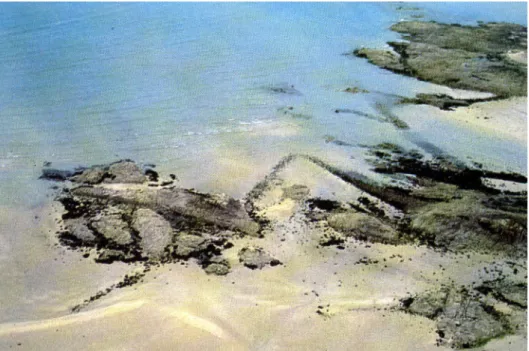
– - Several systematic aerial surveys at low altitude have been carried out during the summer (July and August), a period especially favourable for the detection of submerged or partly submerged remains, such as fish traps, and seawalls (Figure 7). This method is especially efficient during the low tides and supplements the photo-interpretation analysis of high-altitude aerial photos of the IGN (Institut Geographique National)5 (currently freely available on Internet).
- Field surveys, covering both the coastline and inter-tidal areas, which need to be frequently repeated on the same territories because of the continual coastal erosion. Whenever possible, the inland territories of islands are also periodically subject to exploration.
In several case studies, the scientific interest of the archaeological remains leads to a continuation of surveys through excavations and analysis, which is generally linked to thematic research projects. Indeed, sustained surveys are useful for maintaining watchfulness on coastal sites, especially when exposed to coastal erosion.
________________________________________________________
Figure 7: Ancient fish traps, Saint-Jacut-de-la-Mer (photo by L. Langouët).
We can give some quantitative data to illustrate the efficiency of systematic survey campaigns. On Groix island, the first desk-based inventory mentioned a high archaeological potential of 35 sites, especially megaliths distributed over the 1520 hectares of the island. Following two fieldwork surveys of one month each, carried out with a team of three to seven persons, the dataset lists more than 150 archaeological sites or deposits, dating from the Palaeolithic period up to Modern times. While the Neolithic period has long been known on this island (see above), some of the cultural or chronological evidence needs to be revised. This research provides totally new information, on the one hand concerning the early Prehistoric population of the island (especially late Palaeolithic) and, on the other hand, the Roman period. From 2003 to 2006, four expeditions (of three weeks duration each) were mounted that allowed a group of four specialists and six students to obtain more detailed data on some sites (Molines et al., 2004). The Ushant Heritage inventory, carried out in 1990-1991, was also a collaborative study involving 6-8 persons, spending two months in the field. The starting point of the inventory was the mention of 8 archaeological sites, while, as a “final” result, the dataset listed 105 archaeological sites or deposits, unequally distributed over the 1558 hectares of the island (Robic [ed], 1992).
Thematic studies, such as that on the ‘Churches and the Brittany islands’, have led to a detailed inventory and description of 130 medieval churches, chapels, monasteries, etc., distributed over the maritime and estuarine islands of Western France (Molines and Guigon, 1997) (Figure 8). From a methodological point of view, this project showed the complementary nature of field archaeology and textual analysis. The utilization of the database highlights the role played by the islands of Western France in the early
________________________________________________________
Christianisation of the Continent and the central place of the first island hermitages and monasteries (Giot, 1982). More recently, AMARAI participated in the inventory of ancient fish traps of Brittany (Daire and Langouët [eds], 2008). Furthermore, over the past two decades, AMARAI has provided technical and scientific support to some excavation projects carried out on the islands of Yoc’h and Moutons (Finistère), Enez Vihan Island, the Landrellec and Locquémeau peninsulas (Côtes d’Armor), as well as Ilur, Groix and Hoedic islands (Morbihan).
Running since 1989, the AMARAI editorial activity (with a 100-page annual issue of the ‘bulletin’) aims to offer a vehicle for the members and the association to present their activities. More than 2500 pages (in French) have been published so far (Bulletin de
l’AMARAI nos. 1 to 20), corresponding to 140 papers (plus an annual bibliography). The
papers not only deal with French islands and coasts but also the archaeology of the Channel Islands (UK) and even farther a field. The contents of these papers (summaries, thematic studies or inventories and results), cover the whole range of periods and questions linked to modern archaeological science (including palaeoecology, climatology, sedimentary geology, anthropology, etc.). As the older issues of the ‘Bulletin’ are no longer available for sale, the web site of the AMARAI Association is offering digitised versions of the papers in free access (digitising in progress, issues n1 and 2 are now available); the issues n10 and 20 contain a decennial summary index, with geographic, thematic and author name entries.
Amongst the collaborative projects and associations, related to islands studies in North Western Europe and dealing with archaeological matters, several of them are dedicated to specific islands or archipelagos. As an example, the Société Jersiaise was founded in 1873 for the study of Jersey archaeology, history, natural history, the ancient language and the conservation of the environment. Another example in the Channel Islands is La Société Guernesiaise, founded in 1882 to encourage the study of the history, natural history, geography and geology of the Bailiwick of Guernsey, the conservation of the Bailiwick’s natural environment and the preservation of its historic buildings and monuments; its activities also extend into many other areas, including history, archaeology and astronomy. The same approach has been recently developed by the Melvan Association, created in 2003 in order to promote the natural and historical heritage of the Hoedic and Houat islands (southern Brittany), thanks to a transdisciplinary approach. In this panorama, the AMARAI project is less restricted to a geographical point of view but shares several aims in common, even if its specialisation in the ancient peopling and environments appears as the main originality of the project. Island archaeology is relevant to broader island studies as it is based on the understanding of the interactions between human and ‘islandscape’ during the past, concerning the relationship between the “physical nature of islands, as created by their geological, geographical and biological context, and cultural identity, as created by the islanders themselves” (Cooper et al, 2008: 6). Modern archaeology is likely to provide the major methodological and theoretical advances in the study of island and coastal societies, of historical ecology and human impacts on island and coastal ecosystems. A better understanding of the role played by islands and coastal regions, in the construction of human societies over space and time, can lead to a comprehension of some present day situations, and provide solutions, especially in terms of sustainable development. “Island archaeologies… can potentially act as a microcosm for addressing much broader questions, particularly with regard to early seafaring,
________________________________________________________
colonisation, migration, abandonment, resettlement, trade and exchange” (Dawson, 2008: 19). Question of islands heritage management have to deal not only with the archaeological record but also with sustainability, vulnerability, and cultural identity, which is why interdisciplinary projects, such as the AMARAI Association, are so relevant.
Figure 8: Early medieval chapel on the Modez Island (photo by M.Y. Daire).
Plans and perspectives
This brief analysis of the AMARAI Association and its collaborative research shows the efficiency of the fieldwork methods that have been adopted over its 20 years of existence; the systematic surveys of large islands or archipelagos, based on relatively long stays (several weeks), allow the optimisation of transport and improve the cost-effectiveness of travelling expenses and human investment. Furthermore, the relatively long stays on the islands facilitate contacts and exchanges between archaeologists and local people, which represent a very important way of collecting archaeological or historical information. The multi-disciplinary nature of the teams involved in the field and
________________________________________________________
inventory work also help to make the surveys more cost-effective. The longevity of the project can be considered as reflecting its efficiency and the role it plays in the regional research context. AMARAI aims to maintain its network and role as a forum, linking both professionals and non-professionals who are interested in the archaeology of islands in Western France as well as the history of coastal peopling, thus providing a framework for sharing knowledge and experience. Even if the collaborative research is regionally focused, new orientations (and new technologies, such as the Internet) could encourage researchers to open their perspective to a wider scope.
A new scheme will help us to develop in this direction: the “ALERT” project6 considers
the vulnerability of coastal and island cultural heritage in relation to climatic changes (erosion, sea-level rise, etc.). It implements a multi-disciplinary approach and is set up according to several themes:
- an inventory of the coastal archaeological heritage under threat;
- the construction of a vulnerability model for this heritage in terms of the nature of the environment and the dynamic indicators of its evolution (past and future, on a timescale of the next 20 to 30 years);
- the assessment of strategies for research and action adapted to the various scales involved (regional, local and specific);
– the drawing up of maps showing the levels of vulnerability of coastal heritage, which could not only provide research tools for scientists but also assist in the integrated management of coastal zones.
This will be another story. Abbreviations
AMARAI: Association Manche Atlantique pour la Recherche Archéologique dans les Îles (Channel and Atlantic Association for the Archaeological Research in Islands) http://www.amarai.asso.univ-rennes1.fr/
UMR 6566: CReAAH: Centre de Recherche en Archéologie, Archéosciences, Histoire » (Research Center in Archaeology, Archaeosciences, History), Rennes (France)
http://www.archeologie.univ-rennes1.fr/
CNRS: Centre National de la Recherche Scientifique (French National Center for Scientific Research)
INRAP: Institut National de Recherche en Archéologie Préventive (National Institute for Preventive Archaeology).
IGN: Institut Géographique National (National Institute of Geography). ALERT Project: Archéologie, Littoral et Réchauffement Terrestre
________________________________________________________
Bibliography
Baudry A and Daire M.Y (2007) ‘Relationship between men, space and places during the Iron Age’, in Abstract book of the 13th EAA Congress, Zadar, Croatia, September 19-22/09/2007, Zadar: EAA Publishing: 59
Bresc, H and Nef, A (1999) La première géographie de l’Occident, Paris, Flammarion Brigand, L (2002) Les îles du Ponant. Histoire et géographie des îles et archipels de la
Manche et de l’Atlantique, Quimper: Editions Palantines
Cooper J, Dawson H and Rennell R (2008) ‘The Forum for Island Research and Experience (‘FIRE’)’, TEA The European Archaeologist n30: 6-7
Cougny E (1986) Extraits des auteurs grecs concernant l’histoire et la géographie de la
Gaule, Paris: Errance
Cunliffe B (2001) Facing the Ocean: The Atlantic and its peoples, 8000 BC – AD 1500, Oxford: Oxford University Press
Daire, M. Y (1988)‘Quelques aspects de l’archéologie des îles françaises de la Manche et de l’Atlantique’ in Approches comparatives des méthodologies d’étude et
d’expression des résultats de recherche relatives aux systèmes micro-insulaires en Méditerranée et en Europe du Nord, Man and Biosphere (MAB) Workshop Final Report,
Brest: Unesco and Brest University: 26-28
--- (1990) ‘Archéologie insulaire en Bretagne : un point de vue sur les sites de l’Age du Fer’ in La Bretagne et l’Europe préhistoriques. Rennes: Revue archéologique de l’Ouest, supp. n2: 269-278
--- (1991) ‘Recherche archéologique insulaire en Bretagne’, in Territoires et sociétés
insulaires, Brest: Unesco, éd/ Ministère de l’Environnement: 85-89
--- (ed) (2001) Le sel gaulois. Bouilleurs de sel et ateliers de briquetages armoricains à
l’Age du Fer. Rennes: Centre Régional d’Archéologie d’Alet
--- (2001) ‘Un hameau armoricain de la fin de l’Age du Fer sur l’île d’Yoc’h’, in Collis, J.L (ed) Society and settlement in Iron Age Europe, Sheffield: J. Collis and Sheffield University Publishing: 159-189
--- (forthcoming) ‘Des Gaulois sur l’île Guennoc (Landéda, Finistère) (‘Gaulish people on Guennoc Island)’, RAO, Revue Archéologique de l’Ouest n25
Daire, M.Y and Langouët, L (eds) (2008) Les pêcheries de Bretagne Archéologie et
Histoire des pêcheries d’estran, Rennes: AMARAI /Centre Régional d’Archéologie d’Alet
Dawson H (2008) ‘Island archaeologies: themes and challenges’, TEA The European
Archaeologist n30: 19-20
Fitzpatrick, S.M and Erlandson J.M (2007) ‘Highlighting the significance of Islands and Coastal Archaeology’, Journal of Island and Coastal Archaeology v2: 1-3
________________________________________________________
Fitzpatrick S,M and Anderson A (2008) ‘Islands of Isolation: Archaeology and the Power of Aquatic Perimeters ‘ Journal of Island and Coastal Archaeology v3: 4-16
Giot, P.R (1982) ‘Saint-Budoc on the Isle of Lavret, Brittany’ in The early church in
Western Britain and Ireland’, London: British Archaeological Reports n102: 197-210
Gouezin, P (1998) Le site mégalithique d’Er Lannic, Vannes: Douar Mor
Langouët, L (ed) (1989) Un village coriosolite sur l’île principale des Ebihens, Rennes: Centre Régional d’Archéologie d’Alet
Large J.M (2007) ‘Marthe et Saint-Just Péquart: un couple d’archéologues dans les îles du sud de la Bretagne’ in Marthe et Saint-Just Péquart, archéologues des îles. De Houat
à Hoedic, 1923-1934, Nantes: Melvan: 173-212
Le Bihan J.P (ed) (2001) Ouessant, archéologie d’une île à la pointe de l’Europe, Quimper-Rennes: Centre de Recherche Archéologique du Finistère and Revue Archéologique de l’Ouest
Le Roux C.T (1985) Gavrinis et les îles du Morbihan - Les mégalithes du Golfe, Paris: Guides Archéologiques de la France
McCall, G (1994) ‘Nissology: The study of islands’, Journal of the Pacific Society n17: 1-14
Molines N, Daire M.Y and Guyodo J.N (2004) ‘Les premiers peuplements de l’île de Groix’, Penn ar Bed, v190-91: 39-45
Molines, N and Guigon P (ed) (1997) Les églises des îles de Bretagne, Rennes: AMARAI and Institut Culturel de Bretagne
Rainbird, P (2007) The Archaeology of Islands. Topics in contemporary archaeology, Cambridge: Cambridge University Press
Robic, J.Y (ed) (1992) L’île d’Ouessant depuis la Préhistoire. Apports de la prospection
et de l’archéologie, Rennes: AMARAI and Institut Culturel de Bretagne
Scarre, C (2002) ‘A pattern of islands: the Neolithic monuments of north-west Brittany’,
European Journal of Archaeology v5 n1: 24-41
Shima Editorial Board (2007) ‘An introduction to islands culture studies’, Shima: The International Journal of Research into Island Cultures v1 n1: 1-5
Threipland L.M (1943) ‘Excavations in Brittany, Spring 1936’ Archaeological Journal vC: 127-136
Tooley M.J and Shennan I (1987) Sea-level changes, Oxford: Blackwell
Wheeler R.E.M and Richardson K (1957) Hill forts of Northern France, London: Report of the Research Committee of the Society of Antiquaries of London n19