Record Number:
140530
Author, Monographic:
Ouellet, M.
Author Role:
Title, Monographic:
Some paleolimnological aspects of the most recent sediemts of lac
Laflamme (Laurentides provincial park, Quebec) in relation to atmospheric
transportation of pollutants
Translated Title:
Reprint Status:
Edition:
Author, Subsidiary:
Author Role:
Place of Publication:
Québec
Publisher Name:
INRS-Eau
Date of Publication:
1981
Original Publication Date:
Volume Identification:
Extent of Work:
v, 37
Packaging Method:
pages
Series Editor:
Series Editor Role:
Series Title:
INRS-Eau, Rapport de recherche
Series Volume ID: 132 an
Location/URL:
ISBN:
2-89146-129-0
Notes:
Rapport annuel 1980-1981
Abstract:
Rapport rédigé et distribué par Environnement Canada dans la collection
Scientific series no 123
Call Number:
R000132 an
.+
Environment CanadaCanada
Environnement
Canada
Some Paleolimnological Aspects
of the Most Recent Sediments
of Lac Laflamme (Laurentides
Provincial Park, Quebec) in
Relation to Atmospheric
Transportation of Pollutants
Marcel Ouellet*
*
IN RS-Water Université du Québec PO Box 7500, Sainte-Foy Quebec G 1 V 4C7SCIENTIFIC SERIES NO. 123
INLAND WATERS DIRECTORATE, QUEBEC REGION WATER PLANNING AND MANAGEMENT BRANCH QUEBEC, P.Q., 1981
©Minister of Supply and Services Canada 1982 Cat. No. En 36-502/123 E
Contents
Page
ABSTRACT. . . .. . . . v
RÉSUMÉ. . . v
1. INTRODUCTION. . . 1
Effects of water acidification on planktonic communities . . . 2
Phytoplankton . . . 2
Zooplankton . . . 2
Effects of pollutants on the quality of lacustrine sediments. . . 3
Description of study site. . . 3
2. METHODS. . . 4 Sampling. . . 4 137 Cesium. . . 4 Geochemistry . . . 4 Biology. . . 4 Fossil diatoms. . . 4 Fossil crustaceans . . . 4 3. RESULTS . . . 6 Geochemistry. . . 6 Biology. . . 6 Fossil diatoms. . . 6 Fossil crustaceans . . . 6 4. DISCUSSION. . . 18 Geochronology. . . 18 Geochemistry. . . 18 Biology. . . 20 Fossil diatoms. . . 20 Fossil crustaceans . . . 21 5. CONCLUSION. . . 22 REFERENCES. . . 23 PLATES I-V. . . 27
Tables
1. Stratigraphie distribution of geochemical parameters in the most recent sediments of Lac Laflamme. . . 72. Relative abundance of fossil diatoms in the most recent sediments of Lac Laflamme. . . 7
Tables (cont.)
Page
3. Relative abundanee of Cladoeera in the most reeent sediments of
Lae Laflamme. . . 13 4. Classifieation of geoehemieal elements by stratigraphie fluetuations
in the most reeent sediments of Lae Laflamme . . . 19
Illustrations
Figure 1. Geoehemieal diagram of the most reeent sediments of Lae Laflamme 14 Figure
2.
Stratigraphie distribution of 137CS in the most reeent sediments ofLae Laflamme. . . 15
Figure 3. Stratigraphie distribution of AI in the most reeent sediments of
Lae Laflamme . . . 15
Figure 4. Stratigraphie distribution of Ca in the most reeent sediments of
Lae Laflamme. . . 15
Figure 5. Stratigraphie distribution of Fe in the most reeent sediments of
Lae Laflamme. . . 15
Figure 6. Stratigraphie distribution of Na in the most reeent sediments of
Lae Laflamme. . . 16
Figure 7. Stratigraphie distribution of S in the most reeent sediments of
Lae Laflamme. . . 16
Figure 8. Stratigraphie distribution of Co in the most reeent sediments of
Lae Laflamme. . . 16
Figure 9. Stratigraphie distribution of Cu in the most reeent sediments of
Lae Laflamme. . . 16
Figure 10. Stratigraphie distribution of Hg in the most reeent sediments of
Lae Laflamme. . . 17 Figure 11. Stratigraphie distribution of Mn in the most reeent sediments of
Lae Laflamme. . . 17 Figure 12. Stratigraphie distribution of Ni in the most reeent sediments of
Lae Laflamme. . . 17 Figure 13. Stratigraphie distribution of Pb in the most reeent sediments of
Lae Laflamme . . . ' . . . 17 Figure 14. Stratigraphie distribution of Zn in the most reeent sediments of
Lae Laflamme. . . 17 iv
Abstract
The present paleolimnological study, which deals essentially with the geochemical and biological charac-teristics of the most recent sediments of Lac Laflamme, is part of an integrated research program recently initiated by Environment Canada. This research program is aimed at achieving a better understanding of the effects produced on the environment by the fallout of pollutants transported over long distances in the atmosphere.
This report deals with the geochronological and geo-chemical aspects, and with the composition and abundance of the fossil groups of algae and crustaceans over time.
The stratigraphic increase in 137 Cs, Na, Cu, S, Ca, Hg, Ni, Pb and Zn, beginning primarily in the levels cor· responding to the 1940s, reflects the quantities of these elements released into the atmosphere by various anthropo-genic activities. However, for the same period of time, there is a slight decline in AI and Ca levels in the sediments of Lac Laflamme, which may be attributable to the greater mobility of these elements as a result of the effects of precipitation acidification.
To date, the high capacity of the loose sediments in the lake for ion exchange has prevented acidification of the lake's waters, which still maintain a pH level of approxi-mately 6.1. This neutralization capacity has thus enabled the paleocommunities of algae and cladocerans to remain in equilibrium over the past several hundred years.
Résumé
La présente étude paléolimnologique, qui traite es-sentiellement des caractéristiques géochimiques et biologiques des sédiments les plus récents du lac Laflamme, fait partie d'un programme de recherche intégré qui a été lancé dernièrement par Environnement Canada. Ce pro-gramme de recherche vise à mieux comprendre les effets provoqués sur l'environnement par les retombées de sub-stances polluantes transportées sur de longues disub-stances par voies atmosphériques.
Les aspects géochronologiques, géochimiques, amsl que la composition et l'abondance des assemblages fossiles d'algues et de crustacés en fonction du temps font l'objet du présent rapport.
L'augmentation stratigraphique du 137 Cs, du Na, du Cu, du S, du Ca, du Hg, du Ni, du Pb et du Zn et ce, prin-cipalement à partir des niveaux cont~mporains des années 1940, reflète les quantités émises de ceux-ci dans l'atmo-sphère par les diverses activités anthropiques. Par contre, pour le même intervalle de temps, on constate une légère diminution dans les sédiments du lac Laflamme de l'AI et du Ca qui serait attribuable à une plus grande mobilité des ces éléments provoquée par les effets de l'acidification des précipitations.
La grande capacité d'échange ionique des sédiments meubles du bassin du lac a jusqu'ici contrecarré l'acidifi-cation des eaux du lac dont le pH se maintient encore aux environs de 6.1. Ce pouvoir de neutralisation a donc permis aux paléo-communautés d'algues et de cladocères de se maintenir en équilibre depuis les quelque cent dernières années.
Introduction
The transportation of atmospheric pollutants over long distances and the resulting acid precipitation are facts which are now recognized scientifically and politically. In the Scandinavian countries, a number ofstudiesdealingwith the chemistry of this precipitation (Barrett and Brodin 1955; De Bary and Junge 1963; Oden 1968; Bolin et al. 1971;
Oden 1971; Ottar 1972; Dovland et al. 1976; Semb 1978) and with its effects on the various ecosystems (Jensen and Snekvik 1972; Aimer et al. 1974; Grahn et al. 1974; Dickson 1975; Gjessing et al. 1976; Hendrey and Wright 1976; Hendrey et al. 1976; Knabe 1976; Leivestad et al. 1976;
Malmer 1976; Schoefield 1976; Wright and Gjessing 1976; Grahn 1977) have demonstrated that the deterioration in precipitation quality is increasing in intensity and is being felt over ever wider areas.
More recently, in North America, studies by Linzon (1958), Gorham and Gordon (1960), Thomas (1962), Waller (1963), Beamish and Harvey (1972), Beamish (1974), Likens and Bormann (1974), Beamish et al. (1975), Sprules (1975), Dillon et al. (1978a), Gronan and Schofield (1979). Baker and Schofield (1980), Dillon (1980), Harvey (1980), Hendrey et al. (1980), Jones et al. (1980), Schindler et al.
(1980) and Shaw (1980) have also demonstrated that the long-range transport of airborne pollutants and the effects of acid precipitation on terrestrial and aquatic ecosystems are among the major ecological phenomena of the 1980's facing the North American scientific community.
The cause of this acidification of water bodies lies in the acid precipitation generated by emissions of SOx and NO x in such highly industrialized regions as the United Kingdom, Germany, the Sudbury area of Ontario, the U.S.-Canadian Great Lakes and the east coast of the United States.
ln Quebec few studies have been performed to date specifically in this are a with respect to emissions of SOx and NO x from industrial centres. The emission of fluorine into the atmosphere during the process of electrolysis of alumina (A12 03) in the production of aluminum does
not appear to have attracted the attention of the scientific community as a potential source of acid rain. Although Quebec has been a major producer of aluminum for a number of years, to date only Leblanc and Comeau (1972) have studied the effects of the fluorine emitted by the
CHAPTER 1
Arvida aluminum plant on vegetation. Ouellet and Michaud (unpublished) have found fluorine levels in the snow in the vicinity of the Arvida and Isle-Maligne aluminum plants of 23 ppm, or 1000 times higher than those in areas unaf-fected by this industry.
ln contrast, the effects on the environment of the Murdochville copper smelters have been studied by Robitaille et al. (1977) and by Robitaille (1979). Journault-Dupont (1979) has studied the ecological repercussions of the Rouyn-Noranda smelter. 1 n addition, a number of studies (Ouellet 1975; Ouellet and Poulin 1975, 1977; Jones et al. 1976; Ouellet 1978; Delisle 1979) have demonstrated the atmospheric transportation of other substances, including Hg and Pb, over the entire area of Quebec_ More recently, Auclair et al. (1980) and Jones et al. (1980) have studied the evolution of acidity in a number of lakes in Quebec.
ln 1978, in view of the urgent need for a better under-standing of the long-range transport of airborne pollutants and the acid precipitation associated with it, the United States and Canada created an advisory group designed to improve the coordination of research and exchanges of scientific information on long-range atmospheric trans-port. In Europe, the OECD launched a similar program in 1972, with the final report having been submitted in 1977. The report confirmed that pollutants were in fact being transported over long distances and that the quality of the air in ail the countries of Europe has deteriorated signifi-cantly as a result of emissions from neighbouring countries. Since 1977, the European Economic Community (EEC) has been involved in a similar program.
Recently, the U.S.-Canadian advisory research group on the long-range transport of airborne pollutants sub-mitted a preliminary report on the present situation in eastern North America. This part of the continent has been identified as the scene of the most serious problem, because of the. low neutralization potential of the Precambrian geological substratum and the high level of pollutants originating in the industrial regions of the eastern United States and the U.S.-Canadian Great Lakes area. The trans-portation of pollutants from the latter region is facilitated by the prevailing westerly winds through the St. Lawrence River valley. As a result of these factors, it appears that
nearly ail of Ouebec north of the St. Lawrence is potentially subject to acidification and hence to irreversible ecological damage.
ln order to achieve a better understanding of the ef-fects and repercussions of acid rain on Ouebec's terrestrial and aquatic ecosystems, Environment Canada has recently launched an integrated study of these phenomena in the Lac Laflamme watershed, which is located in the southeastern portion of Laurentides Provincial Park.
The present paleolimnological study, which is part of this holistic approach, deals essentially with the char-acteristics of the most recent lacustrine sediments (0-30 cm) of Lac Laflamme. Its aim is to provide a strati-graphic study of the sediments deposited in this lake over the past century by means of various paleolimnological methods, including geochemistry and the composition and abundance of the phyto- and zooplanktonic fossil com-munities. The purpose here is to identify certain anthropo-genic effects related directly or indirectly to the atmo-spheric transport of pollutants.
EFFECTS OF WATER ACIDIFICATION ON PLANKTONIC COMMUNITIES
Phytoplankton
A number of studies performed on acidified and non-acidified lakes in Ontario (Conroy 1971; Conroy et al. 1976;
Kwiatkowski and Roff 1976; Yan and Stokes 1978; Muller 1980; Schindler et al. 1980; Stokes 1980), in Norway (Gjessing et al. 1976; Hendrey and Wright 1976; Wright and Gjessing 1976) and in Sweden (Hornstrom and Ekstrom 1973; Aimer et al. 1974; Grahn et al. 1974;
Dickson 1975) have demonstrated the effects of the acidi-fication of lakes on phytoplanktonic communities. Four principal conclusions emerge from these studies:
2
-the primary productivity of these lakes declines by a factor of from 2 to 10;
-the diversity and number of species in the various communities declines;
-species tolerant of acid environments dominate the communities, while intolerant species diminish or disappear;
-the increase in water transparency and the reduction in nutrients promotes the development of the benthic plant community.
According to the same studies, it is generally accepted that a pH level of 5-6 is often critical for certain species. The number of species increases when the pH of the environment rises above 5.5, but declines when the acidity drops below this level. It would appear that the increased toxicity of the heavy metals in 10w-pH aquatic environ-ments plays an important role in controlling the diversity of the species (Altshuller and McBean 1979). According to Leivestad et al. (1976), in a study of 55 lakes in Norway, the average number of algae species drops from 75 to 21 in lakes with an average pH of 6.0 and 4.0 respectively.
According to Aimer etaI. (1974), the phytoplanktonic flora of Swedish lakes with neutral pH levels generally consists of 35-45% chlorophytes, 25-30% cyanophytes and 10-15%diatoms and chrysophytes. In contrast, according to the same authors, in lakes having pH levels of about 5, blue-green algae (cyanophytes) and diatoms become less abun-dant, while dinoflagellates and green algae (chlorophytes) become more abundant. In some acid-stressed lakes in Ontario, two species of dinoflagellates (Peridinium limbatum
and P. inconspicuum) constitute up to 50% of the
phyto-planktonic biomass (Yan and Stokes 1978; Stokes 1980).
The typical species dominating the phytoplanktonic community in acid lakes are Peridinium inconspicuum, P.
limbatum, Gymnodinium spp., Ankistrodesmus convolutus,
Oocystis submariana, O. lacustris, Dinobryon sertularia, D.
crenulatum, Eunotia spp., Tabellaria binolis and
Amphi-campa hemicyc!us. Mougeotia spp., Eunotia lunaris and
Tabellaria flocculosa are the dominant species in the
periphytic algae community.
Zooplankton
The pH level affects the zooplanktonic community as weil, in terms of both quality and quantity. In this study of 47 mountain lakes in the La Cloche du Nord area, in Ontario, Sprules (1975) has demonstrated that the structure of the zooplanktonic communities is determined largely by the pH and to a lesser extent by the area and depth of the bodies of water concerned. Mesocyclops edox, Cyc!ops bicuspidatus thomasi, Diaptomus minutus,
Holo-pedium gibberum, Diaphanosoma leuchtenbergianum
and Bosmina sp. are the common species found at ail pH
levels (3.8-7.0). Tropocyc!ops prasinus mexicanus, Epischura lacustris, Diaptomus oregonensis, Leptodora kindtii, Daphnia galeata mendotae, D. retrocurva, D.
ambigua and D. longiremis, together with certain other rare
species, represent 64% of ail the species found and are rarely or never encountered at pH levels below 5.0.
Polyphemus pediculus, Daphnia catawba and D. pulicaria
According to the same study, the zooplanktonic communities become more complex as the pH increases. With a pH above 5.0, the communities contain 9 to 16 species; in lakes with a pH of 5.0 or less, the communities include from 1 to 7 species, of which only one or two are dominant. Similar phenomena have been reported in the Scandinavian countries by Aimer et al. (1974) and by Hanson (1974).
EFFECTS OF POLLUTANTS ON THE OUALITY OF LACUSTRINE SEDIMENTS
The addition of pollutants to a watershed, from ter· restrial or atmospheric sources, can affect not only the aquatic communities but also the quality of the sediments of the lacustrine basins. In some cases, when the level of contamination is high enough to affect or endanger the existence of certain species which are capable of leaving fossil traces (diatoms, zooplankton, molluscs, pollen, etc), it is thus possible, using paleolimnological methods, to study various aspects of the evolution of the aquatic environment over long periods of time. The changes brought about by acid rain on the phyto· and zooplanktonic com· munities should therefore be detectable by qualitative and quantitative study of the remains of these organisms pre· served in the sediments. According to Davis and Berge (1980), who have studied the evolution of Diatoma fossils in a number of Norwegian lakes over a stratigraphie interval of 300 years, the acidobiontic species (optimum pH
<
5.5) such as Semiorbis hemicyc/us, Tabellaria binalis,Anomo-eoneis serians, Eunotia bactriana and E. microcephala
are significantly more abundant in the most recent sedi-ments sampled. Davis et al. (1980) have also reported similar paleolimnological changes in their study of a number of short core-samples of sediments from lakes in New England. ln a similar study dealing with the recent evolution of fossil zooplanktonic communities, Brakke (1980) observed a particularly marked reduction in the average number of species in the most recent stratigraphie intervals of certain acidified Norwegian lakes. It appears that acidification has permitted such species as Alonella nana, A. rustica, A.
excisa and Rhynchotalona falcota to become more firmly
established in the zooplanktonic communfty at the expense
of Alona quadrangularis, A. costata, Ghydorus sphaericus
and G. piger.
ln contrast, in certain cases where the level of contamination in the watershed is low, the structure ofthe
commumtles may remain stable for long periods of time. It is possible nonetheless to detect recent input of foreign substances by atmospheric means directly through geo-chemical analysis of the sediments. Ouellet and Poulin (1975,1976,1977), Herron etaI. (1976), Davis and Norton (1978), Norton et al. (1978) and Delmas and Legrand (1980) have demonstrated that atmospheric transportation of trace metals has become an intercontinental phenomenon and that concentrations of certain elements have been rising increasingly rapidly for more th an a century.
DESCRIPTION OF THE STUDY SITE
Lac Laflamme is located (47°19'; 71°07') in the southern portion of Laurentides Provincial Park, within the Montmorency forest, approximately 90 km north of Ouebec City. The geology of this region is complex and as yet relatively unknown. The major portion of the sub· stratum is composed of granitic and igneous Precambrian rocks. Loose deposits, of glacial and fluvioglacial origin, cover the crystalline substratum. These deposits are thicker at low altitudes and frequently absent in the higher areas. Annual precipitation in this region is approximately 1520 mm, and the average annuai temperature is O°C.
The Montmorency forest is part of the Laurentian-Onatchiway forest region (Rowe 1959). It is characterized by coniferous forests dominated by balsam fir and black spruce in association wth white birch and white spruce.
Lac Laflamme lies at an altitude of approximately 800 m, in the centre-east portion of the Montmorency River basin. The area of the lake's watershed is approximately 0.69 km2, while that of the lake is 0.06 km2. The lake is
generally oval, with a maximum depth of only 4 m. Its banks are primarily organic and the dominant plant associ-ations include alders and the marshy stands of spruce at Ledum. Sphagnum spruce forests, last logged during the winter of 1943-44 (personal communication, ML Paul Boulianne), dominate the entire basin of the lake.
During the summer, hydromacrophytes su ch as
Nuphar, Nymphea, Potamogeton, Ghara, and Myriophyllum
occupy nearly 20% of the lake's surface area. According to Jones and Bisson (1980), who give a detailed description of the chemistry of the waters and snow of this lake, the pH is about 6.1, while the average conductivity is approximately 35 Jlmhos/cm.
Methods
SAMPLING
On January 28, 1980, stratigraphic samples of the first 27 cm of organic sediments of lac laflamme were taken by means of an Ekman bucket (30 x 30 x 30 cm), through a 1-m2 opening in the ice cover. This area rep-resented the geometric centre of the lake, where the water reached a maximum depth of 4 m. The stratigraphic column of sediments collected was sectioned off on the spot into intervals of 0.5 cm. In the laboratory, the sedi-ments were stored at 4°C whenever possible.
137 CESIUM
Measurements of 137 Cs were performed on a sample
of approximately 15 9 placed in a plastic container, by means of a 7.5-cm-diameter counting tube connected to a 512-channel analyser. The etficiency of the Na! (Tl) crystal in photopic detection of 'Y emission at 662 keV was established at 26% from standard sediments. Counting time ranged from 45 min to 8 h, depending on the 137 Cs
content.
GEOCHEMISTRY
The pH of the sediments was assessed in the laboratory by means of a pH meter, using 10 9 of fresh sample to which 20 ml of 0.015 M CaCI 2 had been added. After the mixture was shaken for 30 min, it was then allowed to settle for 30 min. The electrode was inserted into the supernatant solution to determine the pH.
Moisture (H 20) and organic carbon content were assessed by means of the weight loss method, with the samples being heated to 110°C and 550°C successively.
The methods of geochemical analysis are based on procedures used by Guimont and Pichette (1979). For metallic sediments su ch as AI, Ca, Fe, Mg, Na, Ag, Co, Cu, Mn, Ni, Pb and Zn, approximately 1 9 of each sample was dried and calcined at 550°C for one hour. The soluble portions of the elements were extracted by means of con-cenfrated nitric acid for 20 min. These metallic elements
4
CHAPTER 2
were measured by means of a Perkin-Elmer atomic absorp-tion spectrophotometer, model 403.
Total S was analyzed by transforming it into S02 by combustion and then quantifying the S02 by means of infra-red rad iation.
The quantity of Hg was determined by extracting 1 9 of each sample by means of sulphuric and nitric acids. The organic material was then destroyed using potassium persulphate and potassium permanganate solutions. Measure-ments were performed by atomic absorption spectrometry, using the cold vapour technique, on an MAS-50 cold vapour atomic absorption spectrophotometer.
BIOlOGY
Fossil Diatoms
The relative abundance of fossil diatoms was esti-mated by placing approximately 0.1 ml of a sub-sample of
sediments from each of the 18 stratigraphic levels studied on a microscope slide. The presence of each species (taxon) appearing on the slide was quantified in relation to the five different classes." If individuals of the same species appeared 70 times or more in 100 different ocular fields, this species was c1assified as abundant (a). The other classes of relative abundance were established as follows: 70-50%-common (c); 50-10%-moderate (m);
<
10%-rare (r); and if the taxonomic group appeared in the 100 microscopic fields only once, it was reported as "trace" (t).Fossil diatoms were identified on the basis of the criteria established by Hustedt (1942), Van Heurck (1963), Patrick and Reimer (1966, 1975) and Contant and Duthie (1978). The other algae were identified by means of the criteria used by Prescott (1962), Takahaski (1978) and Smol (1980).
Fossil Crustaceans
The laboratory technique used to determine the number of individuals fram different fossil zooplankton
species is based on that of Frey (1980). Microscope si ides are prepared by digesting 1 or 2 ml of fresh sediments, depending on the density of the organisms, in a 10% KOH solution heated in a water bath. In order to eliminate undesirable large particles, the solution is then strained through a 20-,um mesh screen. _A micropipette is used to place a guantity of the solution on a microscope slld-e. Under the microscope, each animal structure present along
the transverses is identified and numbered separately. Identification and microscopic counting continue until the largest structure for each of the species present totals the equivalent of 200 individuals for ail species. The fossil crustaceans are identified by means of the criteria established by Frey (1962, 1965, 1976 and 1980). Megard (1967) and Smirnov (1971).
Results
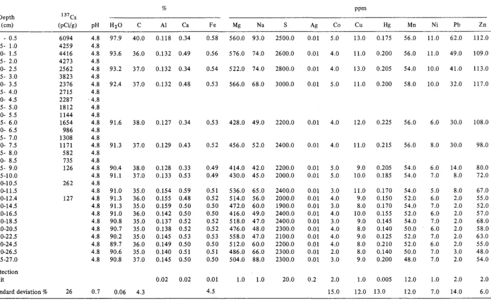
GEOCHEMISTRY
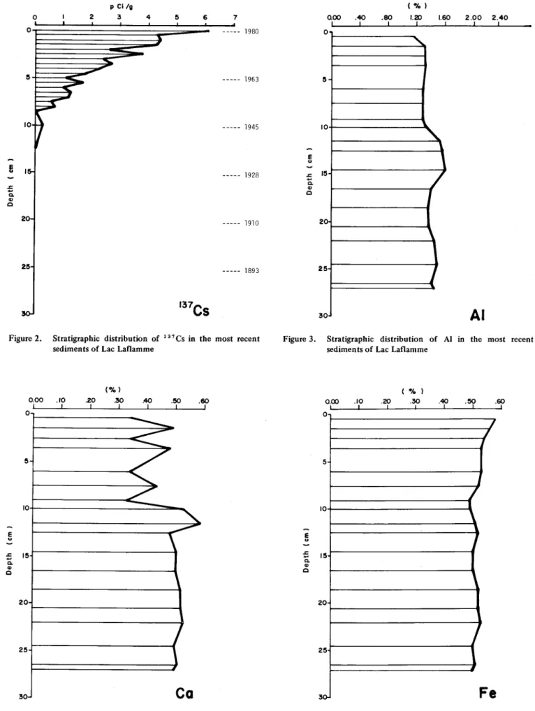
Table 1 gives the geochemical results, together with the detection limit and standard deviation for 137CS, pH, moisture (H20), C, AI, Ca, Fe, Mg, Na, total S, Ag, Co, Cu, Hg, Mn, Ni, Pb and Zn, for 18 stratigraphie intervals.
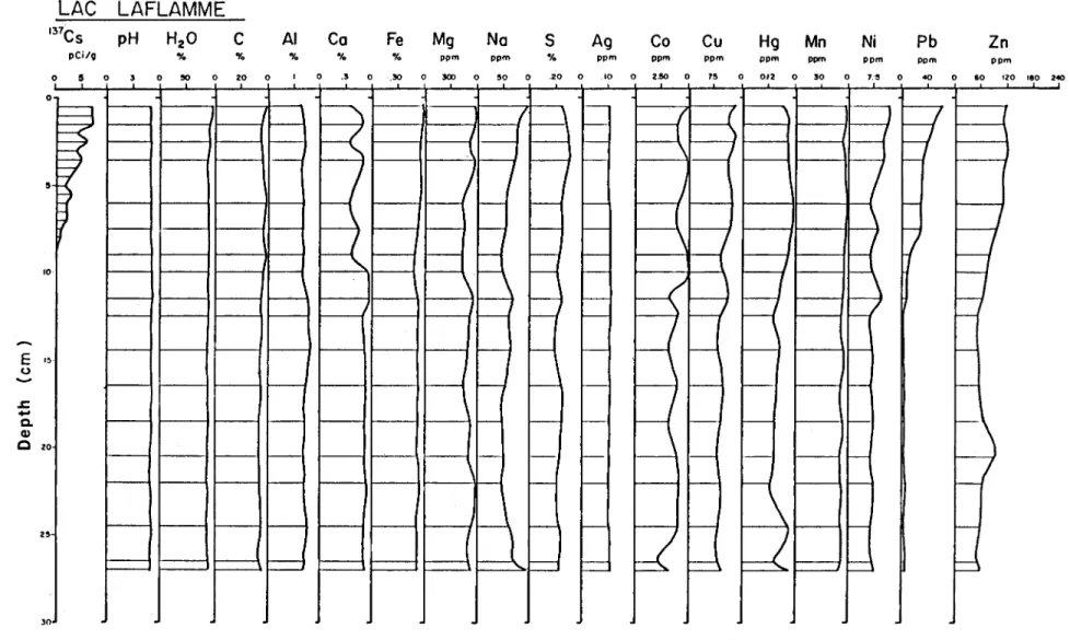
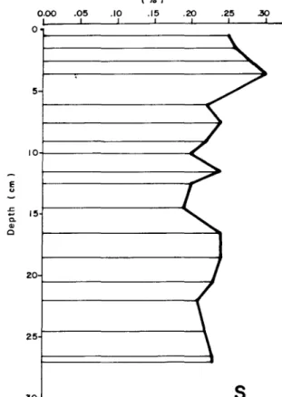
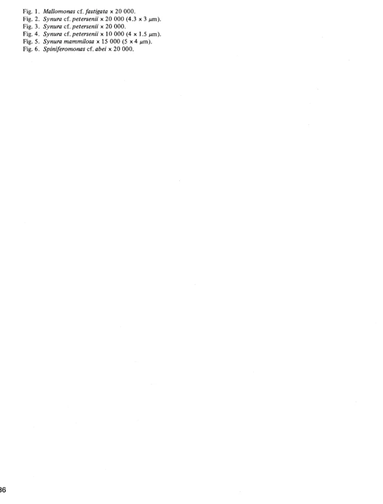
A comparative illustration of the stratigraphie distri· bution of these geochemical parameters appears in Figure 1. Parameters showing relatively major variations in strati· graphie abundance (137CS, AI, Ca, Fe, Na, S, Co, Cu, Hg, Mn, Ni, Pb, Zn) are shown graphically in Figures 2 to 14.
The variables 137 Cs, Ni, Pb, Zn, Hg, and to a lesser extent, AI, Ca, Fe, Na, S, Co and Ca, show the most marked stratigraphie fluctuations, primarily after the 12-cm level. ln contrast, the other variables, including Mn, pH, H20, C,
Mg and Ag, show Iittle or no variation over the intervals studied.
BIOLOGY
Fossil Diatoms
The relative abundance of each taxon identified for the 18 stratigraphie intervals from 0-27 cm appears in Table 2. The comments concerning the environmental conditions suggested by the presence of several indicative species are drawn from Patrick and Reimer (1966, 1975) and from Hustedt (1942) and Pre scott (1962).
The majority of the 91 taxa identified belong to the large group of the Diatoma. Almost ail of these are charac-teristic of an environment that is slightly acidic and low in minerai substances. Amphora normanii and Navicu/a americana are alkalinophilic species which have been identi-fied at certain levels. In addition to the presence of a large number of species that are unaffected by pH conditions, some (approximately 38%) are tychoplanktonic, that is, they come from the littoral zone and are th us largely epiphytic.
ln addition to the diatoms, the cyanophytes and chlorophytes are each represented by three taxa, the
6
CHAPTER 3
chrysophytes by seven and the pyrophytes by a single taxon.
The presence of cyanophytes (Chroococcus sp., Osci/-/atoria Bornetii, O. negra) in the upper portion of the sample is attributable to their differential preservation over time. This is why they have not been found in the under-Iying layers of the sample.
ln general, there is no marked fluctuation in the abundance and composition of the species in the various stratigraphie levels studied. The fossil groups are dominated primarily by Gomphonema truncatum var. capitatum, Me/osira cf. excurrens, M. distans, M. is/andica, Navicu/a e/ginensis and Pinnu/aria acrosphaeria. Other species of secondary importance are Dinobryon sp., Synura petersenii, Navicu/a cuspidata, Tabellaria fenestrata and T. floccu/osa.
Fossil Crustaceans
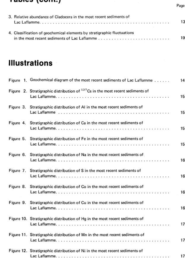
The relative abundance of 20 species of crustaceans of the Order Cladocera preserved in the sediments of seven different stratigraphie levels appears in Table 3.
With the exception of Daphnia catawba, which is characteristic of the limnetic zone (Bernard and Lagueux 1972), ail the 'species are members of the chydorid family and are found in the shore zone. A/ona affinis, A.
quadrangu/aris, A/onella excisa, A. nana, Chydorus sphaericus and Daphnia catawba are the dominant species in the fossil "community" and represent almost 90% of the total. Species accounting for 2-10% are Acroperus harpae, A/ona costata, A. intermedia, A. circumfimbriata, A.
guttata, Chydorus piger and Dispara/ona acutirostris. The other taxa, none of which exceed 2%, are A/ona rustica,
A. exigua, Camptocercus sp., Eurycercus sp., P/euroxus denticu/atus, P/euroxus trigonellus and Grapto/eberis testudinaria.
Most of the species show no marked change between the stratigraphie levels. Only the relative abundance of A/onella excisa (X = 12.66%) and Daphnia catawba
(X
=
20.00%) declines by approximately 50% from the bottom to the top of the stratigraphie interval studied.Table 1. Stratigraphie distribution of geochemieal parameters in the most recent sediments of Lac Laflamme % ppm Depth 137Cs (cm) (pCi/g) pH H20 C Al Ca Fe Mg Na S Ag Co Cu Hg Mn Ni Pb Zn 0 - 0.5 6094 4.8 97.9 40.0 0.118 0.34 0.58 560.0 93.0 2500.0 0.01 5.0 13.0 0.175 56.0 11.0 62.0 112.0 0.5- 1.0 4259 4.8 1.0- 1.5 4416 4.8 93.6 36.0 0.132 0.49 0.56 576.0 74.0 2600.0 0.01 4.0 11.0 0.200 56.0 11.0 49.0 109.0 1.5- 2.0 4273 4.8 2.0- 2.5 2562 4.8 93.2 37.0 0.132 0.34 0.54 522.0 74.0 2800.0 0.01 4.0 13.0 0.205 54.0 10.0 41.0 113.0 2.5- 3.0 3823 4.8 3.0- 3.5 2376 4.8 92.4 37.0 0.132 0.48 0.53 566.0 68.0 3000.0 0.01 5.0 11.0 0.200 58.0 10.0 32.0 117.0 3.5- 4.0 2715 4.8 4.0- 4.5 2287 . 4.8 4.5- 5.0 1812 4.8 5.0- 5.5 1144 4.8 5.5- 6.0 1654 4.8 91.6 38.0 0.127 0.34 0.53 428.0 49.0 2200.0 0.01 4.0 12.0 0.225 56.0 6.0 30.0 108.0 6.0- 6.5 986 4.8 6.5- 7.0 1308 4.8 7.0- 7.5 1171 4.8 91.3 37.0 0.129 0.43 0.52 456.0 52.0 2400.0 0.01 4.0 11.0 0.215 56.0 8.0 30.0 98.0 7.5- 8.0 582 4.8 8.0- 8.5 735 4.8 8.5- 9.0 126 4.8 90.4 38.0 0.128 0.33 0.49 414.0 42.0 2200.0 0.01 5.0 9.0 0.205 54.0 6.0 14.0 80.0 9.5-10.0 4.8 91.1 37.0 0.133 0.53 0.49 430.0 45.0 2000.0 0.01 5.0 10.0 0.185 54.0 7.0 8.0 72.0 10.0-10.5 262 4.8 11.0-11.5 4.8 91.0 35.0 0.154 0.59 0.51 536.0 65.0 2400.0 0.01 3.0 11.0 0.170 54.0 5.0 8.0 67.0 12.0-12.4 127 4.8 91.3 36.0 0.155 0.48 0.52 514.0 56.0 2000.0 0.01 4.0 9.0 0.150 52.0 6.0 2.0 55.0 14.0-14.5 4.8 91.3 35.0 0.159 0.50 0.50 472.0 60.0 1900.0 0.01 3.0 8.0 0.170 54.0 7.0 2.0 52.0 16.0-16.5 4.8 91.0 36.0 0.142 0.50 0.50 416.0 49.0 2400.0 0.01 4.0 10.0 0.155 52.0 6.0 2.0 57.0 18.0-18.5 4.8 90.8 35.0 0.137 0.52 0.52 518.0 47.0 2400.0 0.01 3.0 9.0 0.145 54.0 7.0 2.0 68.0 20.0-20.5 4.8 90.7 35.0 0.138 0.52 0.52 476.0 48.0 2300.0 0.01 4.0 8.0 0.140 50.0 6.0 2.0 58.0 22.0-22.5 4.8 90.2 35.0 0.145 0.53 0.53 558.0 47.0 2100.0 0.01 4.0 9.0 0.125 52.0 7.0 2.0 63.0 24.0-24.5 4.8 89.7 36.0 0.149 0.50 0.50 512.0 60.0 2200.0 0.01 4.0 8.0 0.210 52.0 6.0 2.0 55.0 26.0-26.5 4.8 90.6 35.0 0.140 0.51 0.51 486.0 66.0 2300.0 0.01 2.0 8.0 0.140 50.0 7.0 3.0 48.0 26.5-27.0 4.8 90.8 37.0 0.145 0.50 0.50 504.0 88.0 2300.0 0.01 3.0 9.0 0.200 48.0 7.0 2.0 54.0 Detection limit 0.02 0.02 0.01 1.0 1.0 20.0 0.2 2.0 1.0 0.005 12.0 1.0 2.0 2.0 Standard deviation % 26 0.7 0.06 4.3 4.5 15.0 12.0 13.0 12.0 7.0 14.0 6.0
(Xl
Table 2. Relative abundance of fossil diatoms in the most recent sediments of Lac Laflamme. (a
=
abundant, c=
common, m=
moderate, r=
rare, t=
trace)Depth (cm)
Species 0.5 1.5 2.5 3.5 6.0 7.5 9.0 10.0 11.5 12.5 14.5 16.5 18.5 20.5 22.5 24.5 26.5 27.0 Comments CYANOPHYTA
Chroococcus sp. calm lakes and rivers
Oscillatoria Bornetii m shallow lakes and ponds
Oscillatoria negra m c CHLOROPHYT A Cosmarium sp. euplanktonic Franceia Droescheri c c-m Oocystis sp. CHRYSOPHYTA Chrysosphaerelia brevispina Chrysophyte (cysts) m m r m c m c c m Mallomonas cf. fastigata Dinobryon (cysts) m m m-r c c m m m c m c m m r Mallomonas crassisquama Spiniferomonas cf. abei r r m m Synura petersenii c m m m-c m-c m m m c m m m m m DIATOMACEAE
Amphicampa mirabilis m alkalinophilic
Amphora cf. normanii m epiphytic and weil
oxygenated waters
Amphora ovalis var. fresh to sligh tly
pediculus m m m m m m m m brackish water
Aloneis ventricosa var. alpina
Cocconeis cf. fluviatilis Coscinodiscus sp.
Cyclotella bodanica m c m c m-c m m m r m r c
Cymbella heteropleura var. subrostra
Cymbella cuspidata m m m m slightly acidic to
Table 2. (Cont.) Depth (cm) Species 0.5 1.5 2.5 3.5 6.0 7.5 9.0 10.0 11.5 12.5 14.5 16.5 18.5 20.5 22.5 24.5 26.5 27.0 Comments Cymbella irregularis Cymbella lunata m m m m c Cymbella minuta m m m
Cymbella minuta var. pH immaterial,
minuta m m alkalinophilic
Cymbella inaequalis oligohal~bi~, alkalinophilic
Cymbella tumida oligohalo bic, alkalinophilic
Diploneis elliptica
Eunotia curvata m acidophilic, cold waters
Eunotia bidentula m slightly acidic waters,
low in minerai salts
Eunotia maiora m slightly acidic waters,
low in minerai salts Eunotia maior var. maior
Eunotia Naegelii acidic to neutral waters
Eunotia peetinaZis var.
major acidic to neutral waters
Eunotia pee tinalis var. waters low in minerai salts
ventrieosa
Eunotia praerupta m waters with pH ± neutral
Eunotia soleirolii slightly acidic waters
Eunotia serra m oligotrophic-dystrophic
Eunotia serra var. diadema
Fragilaria construens m m m m m slightly alkaline waters
Fragilaria pinnata
Frustulia rhomboides m m m m slightly acidic waters,
oligotrophic waters Frustulia rhomboides var.
erassinervia m m m c
Fmstulia rhomboides var. pH ± neutral,low
->
Table 2. (Cont.) 0
Depth (cm)
Species 0.5 1.5 2.5 3.5 6.0 7.5 9.0 10.0 11.5 12.5 14.5 16.5 18.5 20.5 22.5 24.5 26.5 27.0 Comments
Frustulia vulgaris r pH ± neutrai
oligotrophic
Gomphonema angustatum r epiphytic and
tychoplanktonic Gomphonema truncatum
var. turgidum
Gomphonema truncatum
var. capitatum m a m c m c c c c c c c c c m c oligotrophic
Melosira cf. excurrens r a c c c c c c c c c c c c-a sligh tIy acidic
Melosira distans c c c c c c c c c c m oligohalobic, alkalinophilic
Melosira granulata
Melosira islandica c c a c c c c c m c c c c c c oligotrophic
Melosira sp. m c c fresh water
Meridion drculare running water
Meridion circulare var.
constrictum running water
Navicula americana r m c m alkalinophilic and pH ± neutrai
Navicula atomus m
Navicula aurora pH ± neutrai
Navicula capitata m m m m m m high tolerance
Navicula cuspidata m m m m-c rom r m m c c m m m high tolerance
Navicula elginensis c c c c m c m m c c c c c c c c c c high tolerance Navicula globulifera
Navicula mutica var. cohrii m a fresh and brackish waters
Navicula latissima
Navicula radiosa c m m rom m common and high tolerance
Navicula schroetieri var.
escambia c
Navicula radiosa var.
tene/la m m m pH ± neutral
Table 2. (Cont.) Depth (cm)
Species 0.5 1.5 2.5 3.5 6.0 7.5 9.0 10.0 11.5 12.5 14.5 16.5 18.5 20.5 22.5 24.5 26.5 27.0 Comments Neidium affine var.
undulatum m lacustrine
Neidium dubium wa ter and rivers
pH immaterial
Neidium gracile aequale m m m m lakes and marshes
Neidium hitchcockii m in rivers
Neidium iridis m
Neidium iridis var. pH immaterial and
amphigomphus m m oligosapro bic
Nitzschia acicularis m m m pH immaterial
Nitzschia filiformis m m m pH immaterial
Nitzschia palea
Nitzschia sp. pH immaterial
Pinnularia abaujensis c m c c m waters low in
minerai salts and tychoplanktonic Pinnularia acrosphaeria c a a c-a c c m c-a c-a c a c m c m m m m pH ± neutral in lakes and ponds Pinnularia divergens
Pinnularia gentilis m m m waters low in
minerai salts and tychoplanktonic Pinnularia latevittata
Pinnularia maior m m m m m m m m waters low in
minerai salts and slightly acidic Pinnularia maior var.
transversa
Pinnularia nobilis m a m m m m waters low in
minerai salts and slightly acidic
Pinnularia polyonca a m tychoplanktonic
Stauroneis acuta c c c m m m m tychoplanktonic and
l'V Table 2. (Cont.)
Depth (cm)
Species 0.5 1.5 2.5 3.5 6.0 7.5 9.0 10.0 11.5 12.5 14.5 16.5 18.5 20.5 22.5 24.5 26.5 27.0 Comments
Stauroneis acuta var. acuta m streams and lakes
Stauroneis anceps m m m c c m m m m c c mq eurytrophic and
pH immaterial
Stauroneis phoenicentron m m m-r m m oligohalobic and
pH immaterial
Surirella elliptica m tychoplanktonic
Surirella linearis m m m m tychoplanktonic
Surirella ovalis tychoplanktonic
Surirella robusta var.
splendida tychoplanktonic
Surirella sp. (large) m tychoplanktoniç
Surirella sp. (small) m euplanktonic
Synedra delicatissima sligh tly brackish waters
Synedra radians Synedra sp.
Tabellaria [enestrata m m m-c m m m m m m-r epiphytic and waters
pH ±neutral
Tabe/laria f/occulosa m m m m m m r high tolerance
Tetracyclus lacustris PYRROPHYTA
Peridinium sp. plates only POLLEN Betula m r m c-m Pinus (large) c r-m m m m c-m Pinus (small) Picea c Sphagnum (leaf) OTHERS
Arce/la cf. vulgaris ponds
Euglypha sp. Cladoceran (de bris)
w Species Fungae Ostraeodes (valves) Needles of rough sponges
Needles of smooth sponges
0.5 1.5 m Table 2. (Cont.) Depth (cm) 2.5 3.5 6.0 7.5 9.0 lO.O 11.5 12.5 14.5 16.5 18.5 20.5 22.5 24.5 26.5 27.0 Comments m m
Table 3. Relative abundanee of Cladocera by stratigraphic interval in the most recent sediments of Lac Laflamme, Quebec. The percent age of each species is calculated from a total eount of approximately 200 individuals per level.
Alona Alona
Depth Acroperwi Alona Alona Alona quadran- Alona circum- Alona Alonella Alonella (cm) harpae affinis costata intermedia gu/aris rustica fimbriata guttata excisa exigua
0.5 3.65 13.54 2.08 0.00 20.83 1.04 13.54 0.00 5.73 1.56 1.5 4.50 17.12 2.70 0.90 13.51 0.00 7.21 0.00 8.11 0.90 3.5 6.25 21.09 3.13 1.56 7.81 0.00 3.91 0.00 9.38 0.00 6.0 4.85 20.39 2.91 0.00 9.71 0.00 5.83 0.97 9.71 0.00 7.5 5.71 25.71 1.43 0.00 12.86 0.00 8.57 1.43 15.00 0.00 11.5 1.39 16.67 0.00 1.39 16.67 0.00 4.86 2.78 15.28 1.39 26.5 3.80 17.72 1.27 2.53 17.72 0.00 5.06 1.27 12.66 1.27 Depth Alonella Camptocercus Chydorus Chydorus Disparalona Eurycercus Pleuroxus Pleuroxus Graptoleberis Daphnia
(cm) nana sp. sphaericus piger acutirostris sp. denticulatus trigone/lus testudinaria catawba
0.5 14.58 0.00 15.63 3.13 2.08 0.00 1.04 1.04 0.52 9.86 1.5 18.02 0.00 17.12 4.50 3.60 0.00 0.90 0.00 0.90 15.27 3.5 17.19 0.00 16.02 3.91 8.98 0.00 0.00 0.00 0.78 16.34 6.0 15.53 0.00 14.56 3.88 1.43 1.43 0.00 1.43 1.43 19.69 7.5 13.57 0.00 5.71 4.29 1.43 1.43 0.00 1.43 1.43 22.22 11.5 20.14 1.39 13.89 1.39 1.39 0.00 0.00 0.00 1.39 26.15 26.5 16.46 1.27 11.39 2.53 2.53 1.27 0.00 0.00 1.27 20.00
.j)o.
LAC
137Cs
o 10E
I~ o .r:...
C. al C 20 25 lO pCi/; 0 5LAFLAMME
pH
H
20
C
"10 "10 0 0 !!O 0 20 f 1 -1 - - - ' 1 -I - - ! 1 -1 - - - 1 1 -1 - - - f -I - f -l - I -l - I 1 -1 l-AI
Ca
Fe
Mg
Na
5
Ag
Co
Cu
Hg
"10 % % ppm ppm "10 ppm ppm ppm ppm 0 0 .5 0 50 0 500 0 50 0 .20 0 .10 0 uo 0 15 0 0.121-
J---.\1
r---J
R
~
1-1-/
t-- f -1 - -r-1
r - -
I - f -1 -r---l
t - - 1-I
1---1 1--r -
I--H
f----f - - 1 - - - c . - I--r -
I - - !---JtJ
1 - --
f---i 1----1 1-' - -
: -1--\
H
1-\
R
B
f-...-- 1 - - - r--- 1 -f - - t - - - r - - - 1 - - f----, 1-- 1 - -H
f - - 1 - - - f - - - 1 - - 1--- t-- 1-- ~ 1---f - - 1 - - - - 1----1 1 - - t - - - 1 - -~
r -
i -I - I - - - 1 - - - 1-- t - - t - -H
l - i -f - I - - I - I -- -
l - I - I - J -f - I - - t - - 1 - - - 1 - -H
1 - - l - I-ti
1 - - 1-- l - I - -\
1 ! I -I - - I - - -U
t - - - 1 - -bl
1 ~U
1 - - - 1 - -1--Figure 1. Geochemical diagram of the most recent sediments of Lac Laflamme
Mn
Ni
Pb
Zn
ppm ppm ppm ppm 0 50 0 1':!1 0 40 0 60 120 180 2<0~
J=;
f f-\
hEl
1
ê
i . - l--1 f-- 1--1 - - - - >--1--1 f1-H
1 - - - 1--1 - - - f--- 1--1 - - 1--1-- f1-P
U
1 - -1--o
li
;; Q, Q) c 25 o,
2 p Cl/g 3 4 5 6 7 1980 --- 1963 --- 1945 --- 1928 --- 1910 --- 1893 137Cs
Figure 2. Stratigraphie distribution of 137 Cs in the most reeent sediments of Lae Laflamme
0.00 1 0 5 10 E u ;; 15 Q, Q) c 20 25 30 Figure 4. (%) .10 .20 .30 .40 .50 .60 1 1 1 1 1 1
---
-
---/
"
~
--
"-
---,
1
Ca
Stratigraphie distribution of Ca in the most reeent sediments of Lae Laflamme
E u .J: ë. Q) c aoo 1 o 5 10 15 20 25 30 .40 .80 1 (%) 1.20 1
"
1.60~
J
l
,
j
2.00 2.40 1AI
Figure 3. Stratigraphie distribution of Al in the most reeent sediments of Lae Laflamme
E u ;; Q, Q) c Figure 5. -A, ) 0.00 .10 .20 .30 .40 .50 .60 0 5 0 5 2 0 2 5 3 ,0-1 1 1 1 1 1 1
/
1
/
1~
l
1
F
e
Stratigraphie distribution of Fe in the most reeent sediments of Lae Laflamme
E ~ .s::;
-
c. CI> c QOO 1 o 5 10 15 20 25 30 25 1 ppm 50 1 75 1 ~ 1 . //
\
/
\
"'
. /\
/
\
\
100 1Na
Figure 6. Stratigraphie distribution of Na in the most recent sediments of Lac Laflamme
E u ;:; c. CI> c ppm 1 0.0 2 3 4 5
O~---~
5 10 15 20 25 30Co
6 1Figure 8. Stratigraphie distribution of Co in the most recent sediments of Lac Laflamme
(Ofol 0.00 .05 .JO .15 .20 l 1 1 1 1 0 5 10+---~ E u ;:; 15 c. CI> C 20~---" 25 30 .25 .30 1 1
s
Figure 7. Stratigraphie distribution of S in the most recent sediments of Lac Laflamme
E u ;:; c. CI> c QOO 1 4 1 ppm 8 1 12 1 o 1 - - - , 7 5 10 15 20 25 30
Cu
16 1Figure 9. Stratigraphie distribution of Cu in the most recent sediments of Lac Laflamme
E
"
..c:: .... a. Cl) C 0.00,
.05,
ppm .10 .15 1 1 01-_ _ _ _ _ _ _ _ _ .... 5 10 15 20 25 30 .20,
Hg
.25 1 E ..c:: .... a. Cl) C 0.00 1 o 5 10 15 20 25 30 15 1 ppm 30 1 45 1j
,
j
J
1 ~J
Mn
60 1 E"
0.00 2.5 1 1 ppm 5.0 7.5 , 1 10,
o 1---___________________ -. 5 10+---~ :: 15 a. Cl) C 20 2 30Ni
12.5,
Figure 10. Stratigraphie distribution of Hg in the most reeent sedi-ments of Lae Laflamme
Figure 11. Stratigraphie distribution of Mn in the most reeent sedi-ments of Lae Laflamme
Figure 12. Stratigraphie distribution of Ni in the most reeent sedi-ments of Lae Laflamme
E
"
..c::....
a. Cl) c 0.00,
10 1 20 1 ppm 30 1 40 1 50 1 60 1 o~ _____ . ______________________ ~ 5 20 25 30Pb
10 1Figure 13. Stratigraphie distribution of Pb in the most reeent sediments of Lae Laflamme
E
"
..c:: .... a. Cl) c 0.00 1 20 1 40 1 ppm 60 1 80 1 100 1 o~ __________________________ ...., 5 10 15 20 25 30Zn
120 1Figure 14. Stratigraphie distribution of Zn in the most reeent sediments of Lae Laflamme
Discussion
GEOCHRONOLOGY
Quantification of the artificial and natural radio-elements in the environment, including 137 Cs, 3 H (tritium), 14 C, 210 Pb and the isotopes, is a method cur-rently used in the field of geochronology of recent sedi-ments (Krishnaswami et al. 1971; Ouellet and Poulin 1976;
Robbins 1978; Robbins et al. 1978; Smith and Walton
1980; etc).
For unknown reasons, the stratigraphie distribution of 137CS in the sediments of Lac Laflamme (Figs_ 1 and 2)
is very unusual. The concentrations of this element, which measure more than 6000 pCi/g at the surface, are approximately 200-700 times higher than any other con-centration reported in the titerature. Plato (1972) and Robbins et al. (1978) report maximum concentrations of
8.07 and 21.3 pCi/g.
This curve is also unusual in that it should drop in the top few (0-3) cm. This fact is related to the maximum abundance of this element in the atmosphere, which culminated with the numerous test explosions of nuclear bombs that took place in 1961-62.
The extremely organic nature of the sediments (40%)
may weil explain the very high activity of 137 Cs in the sedi-ments of Lac Laflamme. There does not appear to be any record in the literature of analysis for 137 Cs in highly organic sediments like those in the present study. Smith and Walton (1980) have found that excess concentrations of 210 Pb in the organic portion (4%) of the sediment layers in the Saguenay are higher by a factor of two. The authors attribute this fact to the higher power of absorption of lead and of the heavy metals by organic matter, which is largely autochthonous in origin, compared with inorganic matter, which comes mainly from the terrigenous environ ment. Ouellet (1979) has also demonstrated a higher power of complexing of the heavy metals by fine organic and inorganic matter in his study of the superficial sediments of the Saguenay River and Lac Saint-Jean.
As regards the exponential form of the stratigraphie distribution of 137CS and the absence of a maximum at the
18
CHAPTER 4
level corresponding to the period 1961-62, there are three plausible explanations. The re-suspension of surface sedi-ments by physical or biological agents and their preferential re-deposition at the sampling point may be the cause. If we consider the lake's relatively shallow depth of 4 m, this seems highly plausible. Secondly, the fact that the radio-logical act'ivity of 137 Cs in the most recent sediments is higher than anticipated on the basis of contemporary fall-out in these strata could be the result of its transportation from the watershed. Thirdly, the role of the lake's many hydromacrophytes in recycling 137 Cs remains unknown and may weil influence the stratigraphie distribution.
Although the 137 Cs curve includes a number of ir-regularities, it is still useful for evaluating the rate of sedi-mentation in the lake. If we recall thatthe presence of 137CS in the environment is the result of the nuclear testing that began in 1952 (Health and Safety Laboratory, 1972),
Figure 2 enables us to deduce that this date corresponds to the stratigraphie level of 8 cm. Because of the percentage of error in the analysis of 137 Cs, there is no point here in al-lowing a period of one or two years for the transportation process. If we consider the stratigraphie level of 8 cm as contemporary with the year 1952, the annual sed imentation rate is thus 2.85 mm.
This high rate of sedimentation appears plausible considering pelagie production and annual allochthonous input as weil as the organic material generated by the hydro-macrophytes that abound in ail the shallow portions of the lake. The very slight compaction of the most recent sedi-ments also contributes to over-estimation of the average rate of sedimentation of the entire postglacial deposit. Ouellet and Poulin (1975, 1976) have estimated the average rate of postglacial sedimentation in Waterloo and Matamek lakes at 1 mm/year.
GEOCHEMISTRY
ln order to facilitate the discussion ofthe geochemical e'ements in Figure 1, they are classed in three groups on the basis of their stratigraphie fluctuation (Table 4).
Table 4. Classification of geochemical elements by strati-graphie fluctuations in the most recent sedime ts of Lac Laflamme.
Number Elements F1uctuati n 137Cs, Cu, Hg, Ni, Pb, Zn Major
2 Al, Ca, Fe, Na, S, Co, Mn Moderate 3 pH, H20, C, Mg, Ag None
The first group includes 137 Cs (Fig. 2), Cu (F g. 9), Hg (Fig. 10), Ni (Fig. 12), Pb (Fig. 13) and Zn (Fi. 14), which are the elements showing major quantitative fi ctua-tions over time. The concentration of these elements in the core-sample increases perceptibly, primarily after the 2-cm level (1940). The average factor of anthropic enrich ent is 6000 (137CS). 1.5 (Cu), 1.4 (Hg). 1.8 (Ni), 30.0 (P ) and 2.0 (Zn) respectively. For the second group, the form f each curve varies slightly, again after the 12-cm level, neg tively for AI (Fig. 3) and Ca (Fig. 4) or positively for Fe ( ig.5). Na (Fig. 6) and Co (Fig. 8). The concentrations of S ( ig.7) and Mn (Fig. 11) first increase and then decrease ithin the same stratigraphie interval.
The third and last group, which includes pH, H 0, C, Mg and Ag, shows no stratigraphie fluctuation over ny of the different levels of the short core-sample studi d and their detailed stratigraphie distribution is thus not hown in the present report.
Assuming there has never been any major distu bance within the watershed, the causes of the substantial increase in Pb, Ni, Zn, Cu and Hg, as discussed previously for 37 Cs, can only be related directly or indirectly to atmospheric transportation. The increase of these elements in the tmos-phere affects the quality of the sediments in Lac Laf amme through both wet and dry types of fallout.
The use of fossil fuels as an energy source, together with the products given off by refineries of sulphurous ores, is thought to be the primary source for the recent i crease of these elements in the atmosphere (Bertine and G Idberg 1971; Journault-Dupont 1979). Ouellet (unpublish d) has demonstrated that the recent increase of these elem nts in lacustrine sediments is a general phenomenon thro ghout Ouebec.
Ouellet and Poulin (1976) and Ouellet (198 ) have estimated, on the basis of the appearance of Ambrosia ollen, that the increase of Pb in the sediments of Lac Sai t-Jean and Lac Waterloo corresponds to the period of defore tation of the watershed for agricultural purposes, which 0 curred
around the years 1850 and 1830 respectively and hence
long before the date of 1940 for Lac Laflamme. It could be that the increase of Pb in the lacustrine sediments coming essentially from atmospheric sources, as in Lac Laflamme, is a more recent phenomenon than that of Pb transported by water and originating to a large extent directly from human activities within the watershed of the lake.
The anthropic increase in Cu is certainly not as dramatic as that of Pb, but if the ideal curve is traced for the points reflecting the stratigraphie distribution of this element, the slope of the curve isalwayspositive (Fig.9) and it is marked by a break in the slope at approximately the 12-cm stratigraphie level. One can deduce from this that the presence of Cu in the atmosphere is a phenomenon which began slowly over half a century ago but took a marked upturn during the 1940s.
The standstill in the increase of Zn beyond the 6-cm stratigraphie level, that is, since approximately 1960, may weil be explained by a reduction in the consumption of pol-luting fuels, such as coal, which has been reflected in Ouebec by an increase in the consumption of oil and electricity, which are less polluting energy sources. On the other hand, greater acidification of the lake waters may have facilitated the liberation of Zn and its transportation outside the basin, although this is highly unlikely in the present situation in view of the fact that the pH of Lac Laflamme is still 6.1.
The sa me reasons might also explain the decrease in Hg for the 0-6 cm stratigraphie interval. This curve resem-bles the one described by Thomas (1972) in his study on the evolution of Hg in the sediments of Lake Ontario. He explains its decline as the result of the greater restric-tions placed on the use of this element by various bodies in recent years.
The reasons for the evolution of the curves for the second group of geochemical elements (AI, Ca, Fe, Na, S,
Co, Mn) over the past 100 years or so remain much more speculative than those discussed above for the first group. These stratigraphie variations are relatively small because some of these elements are rarely transported by atmospheric means or because certain underlying phenomena, such as pH and Eh, can influence the quantitative aspect indirectly, either in the various phases of the metabolism of the lake or in the watershed as a whole.
The reasons for the decreased levels of AI and Ca in the sediments of the upper portion of the core-sample are probably chemical in nature. It is weil known that AI (Burrows 1977) and Ca (Watt et al. 1978. Henriksen 1979; Jones et al. 1980) tend to increase and to decrease their mobility respectively with the acidification of the surface
waters. Although the average pH of the waters of Lac Laflamme remains above 6.0, Jones and Bisson (1980) have measured minimal pH levels of 3.9 in the snow and in the spring meltwater.
It is therefore logical to assume that even though the input of these two elements into the lake has probably increased over the past 40 years (12-cm level), net losses have also increased simultaneously as a result of the greater solubilization of these elements, prirnarily in the spring. In contrast, the maximum Ca level of 0.59% at the 11-cm stratigraphic level could weil be associated with the eftects of the most recent logging operations, which took place in
1943-44.
It would certainly be interesting to compare the decline of these elements in the sediments of Lac Laflamme with those of an acidified lake, such as Lac Tantaré, sorne 60 km to the southwest. We can conclude that the geologi-cal substratum and, in particular, the loose deposits of the Lac Laflamme basin possess a relatively high buffering power which is still able, through its high capacity for ion exchange, to minimize the effects of the acidity (pH 4.1; Jones and Bisson 1980) of the solid and liquid precipitations.
The continuing increase in Na and the more moderate increase in Fe in the sediments of Lac Laflamme over the past 30 years may be directly associated with the higher concentrations of these elements in the atmosphere and hence in both wet and dry forms of precipitation. The in-creasingly intensive use of NaCI as a road-salting agent in recent years appears to be one of the principal sources contributing to this increase. As with many other elements, it may be that the acidification of precipitation brought about by emissions of SOx and NO x into the atmosphere has promoted a si ight leaching of Na and Fe in the water-shed and hence their use by aquatic organisms and sub-sequent deposition through the various processes of lacus-trine sedimentation. Particularly in the case of Fe, the filling in of the lacustrine basin by the accumulation of sediments will, despite the shallowness of the lake, promote an even more rapid rate of hypolimnic oxygenation and hence the precipitation of Fe in the form of Fe(OHlJ, FeO(OH) or its co-precipitation with other elements.
The behaviours of S (Fig. 6) and Mn (Fig. 9) remain difficult to explain because of their slight stratigraphic fluctuations. The very slight increase in S up to the 6-cm level and the subsequent sharper rise to a maximum at the 3.5-cm level may certainly be of atmospheric origin. Its decline, beginning in the late 1950's, also correspondstothe reduction in Hg (Fig. 8) and Zn (Fig. 12). It is thus possible that the curve for S also reflects the reduced use of fossil
20
coal as an energy source as weil as the effects of the anti-pollution measures introduced in recent decades.
Although the curve for Co shows a slight increase at about the 12-cm level, it is so minor that no valid inter-pretation can be offered. The same is generally true of Mn. The reasons for the stratigraphic variations of Mn remain obscure_ ln a number of paleolimnological studies, Ouellet and Poulin (1974, 1975, 1976) and Ouellet (1978, 1979) have shown that Mn can vary positively or negatively over the postglacial lacustrine deposits as a whole independently of the organic matter. Acidification of precipitation tends to enhance the solubilization of the Mn in the geological substratum (Jones et al. 1980) and, as with Fe, this should be reflected in an increase in lacustrine sediments caused by the precipitation or co-precipitation of this element in the aerobic aqueous environment. The stratigraphic fluctua-tion of this element at the 3.5-cm level is so slight that it seems to be insignificant. It is interesting, however, to note that this slight decline corresponds to the decline in S, Hg and Zn as weil. A reduction in fallout from atmos-pheric sources is thus also plausible.
Finally, for the third and last group of geochemical variables (Table 4), including pH, H20, C, Mg and Ag, ail
of which are characterized by little or no quantitative fluctuation over time, there may be two principal reasons for this situation. The behaviour of pH, H20, C and Mg
may reflect the absence of significant disturbances within the watershed (forest fires, logging) or even within the lacustrine basin (accelerated eutrophication). The relatively low level of Ag, which was close to the detection limit for the method of analysis used, makes it impossible to demon-strate the existence of any evolutionary tendencies.
Stratigraphic study of the sediments of a number of highly acidified lakes would enable us to determine the causes of these geochemical fluctuations more accurately_ ln such lakes, the reduction of certain elements will be more obviously associated with the physico-chemical effects of the pH level than with the direct input of these elements into the watershed by atmospheric means.
BIOLOGY
Fossil Diatoms
The great majority of the diatoms in the fossil groups are characteristic of cold, slightly acidic waters with low minerai content.
The abundance and stratigraphie diversity of the 91 taxa identified in the most recent sediments of Lac
Laflamme show no sustained fluctuation that could be interpreted as the result of paleoecological changes in the environmental conditions of the lacustrine environ ment. Even around the 12-cm level (1952), where certain geochemical disturbances have been detected and discussed earlier in this study, there is no indication of changes in the fossil groups that could be firmly associated with the effects of acid precipitation.
Some acidophilic species, such as Tetracyclus /acustris
and Amphicampa mirabilis, which are absent in the lower
portion of the sample, make a slight appearance towards the 2.5-cm level. In the present situation, it is quite possible that their presence in the spectrum of the various taxa is the result of diagenesis of the sediments, resulting from their differential preservation, as in the case of the cyano-phytes. The presence of trace levels of these two species at a single lower level in each case does not completely eliminate this hypothesis.
Although the increase in the various acidophilic species of Eunotia spp., which appear in greater diversity and abundance towards the upper portion of the lacustrine deposit, can be interpreted as progress towards acidification of the environ ment, the evolution of other alkalinophilic species seems to be indicative of the opposite tendancy. These species, such as Amphora cf. normanii and Navicu/a
americana, also assume some importance at the superficial
and intermediate levels (11-11.5 cm) and thus contradict this possible tendency towards acidification. The increase in the diversity and abundance of these alkalinophilic species could be the result of the effects of a forest fire in the watershed of Lac Laflamme prior to 1952, which would have promoted the development of alkalinophilic species through the production of basic salts. In Scandinavia, sys-tematic efforts have been made to burn off island ve~etation
in order to minimize the effects of lake acidification
(personal communication, Rosenquist). In the case of the Lac Laflamme basin, this hypothesis must be rejected because of the presence of a coniferous forest approxi-mately 40 years old. In addition, the effects of this hypo-thetical fire would have certainly brought about more sig-nificant changes in the geochemical composition of the lacus-trine sediments. It should be noted here that the slight increase in Ca in the sediments, which appears to have been caused by logging operations in the basin in 194344, also corresponds to an increase in the diversity and abundance of these alkalinophilic species.
1 n short, the 91 taxa of fossil algae identified in the 18 stratigraphic levels of the most recent sediments (O-100 years) of Lac Laflamme indicate no significant paleoenvironmental changes resulting from the effects of acid rain. The evolution in the diversity and abundance of several species, which are present only in very small quantities, could possibly be indicative of acidification, whereas, at the same time, certain others tend to suggest alkalinization. This situation is thus contradictory and ambiguous.
Fossil Crustaceans
The evolution of the fossil zooplanktonic groups of the seven stratigraphie levels of Lac Laflamme studied reveals no tendency which can be associated with the acidi-fication of the lacustrine environment. Only the distribution
of Daphnia catawba, which unlike the other species, is
characteristic of the limnetic zone, varies significantly in abundance. This reduction towards the upper levels may be a consequence of the expansion of the riparian zone rather than the acidification of the environment. This species cannot tolerate a pH below 5.2, a level not yet reached in Lac Laflamme.