O
pen
A
rchive
T
OULOUSE
A
rchive
O
uverte (
OATAO
)
OATAO is an open access repository that collects the work of Toulouse researchers and
makes it freely available over the web where possible.
This is an author-deposited version published in :
http://oatao.univ-toulouse.fr/
Eprints ID : 13219
To link to this article : DOI :10.1007/978-3-319-08599-9_15
URL :
http://dx.doi.org/10.1007/978-3-319-08599-9_15
To cite this version : Kammoun, Slim and Macé, Marc and Jouffrais,
Christophe
Waypoints validation strategies in assisted navigation for
visually impaired pedestrian. (2014) In: International Conference on
Computers Helping People with Special Needs - ICCHP 2014, 9 July
2014 - 11 July 2014 (Paris, France).
Any correspondance concerning this service should be sent to the repository
administrator:
[email protected]
Waypoint Validation Strategies in Assisted Navigation
for Visually Impaired Pedestrian
Slim Kammoun1, Marc J-M. Macé2,3, and Christophe Jouffrais2,3
1
Research Laboratory of Technologies of Information and Communication & Electrical Engineering, University of Tunis, Tunisia
2 CNRS, IRIT, Toulouse, France 3
University of Toulouse, IRIT, Toulouse, France {mace,jouffrais}@irit.fr
Abstract. In Electronic Orientation Aids, the guidance process consists in two
steps: first, identify the location of a visually impaired user along the expected trajectory, and second, provide her/him with appropriate instructions on direc-tions to follow, and pertinent information about the surroundings. In urban envi-ronment, positioning accuracy is not always optimal and tracking the user’s progress along the expected itinerary is often challenging. We present three new waypoint-based validation strategies to track the user’s location despite low po-sitioning accuracy. These strategies are evaluated within SIMU4NAV, a multi-modal virtual environment subserving the design of Electronic Orientation Aids for visually impaired people. Results show that the proposed strategies are more robust to positioning inaccuracies, and hence more efficient to guide users.
Keywords: Assisted Navigation, Guidance, Virtual Environment, Assistive
Technology, Wayfinding.
1
Introduction
One of the main consequences of visual impairment is a reduced autonomy in terms of mobility and orientation. Electronic Orientation Aids (EOAs) have been proposed to compensate for wayfinding issues, and help visually impaired people in their daily travels. EOAs provide users with directions along planned itineraries, and also include landmark indications and spatial descriptions [1] . Hence, EOAs are essential devices which, in conjunction with traditional mobility aids, such as the long cane or guide-dog, improve wayfinding autonomy of blind people.
EOAs are usually based on 3 essential components: 1) A positioning system (e.g. GPS); 2) A Geographical Information System (GIS) that includes both a digitized map and software designed to calculate routes and extract environmental features; 3) A User Interface that relies on non-visual (i.e. auditory or tactile) interaction. In addi-tion to these three components, an EOA contains a central processing unit that performs all the computation (user tracking & guidance; space description…) and ensures efficient communication between the components.
The guidance process in an EOA consists first in identifying the location of a vi-sually impaired user relatively to the expected itinerary (tracking), and then provides her/him with appropriate direction instructions (guidance, which may be enhanced with space description). Obviously, a precise estimation of the user’s position during tracking is essential in order to provide an accurate guidance. For instance, it may be impossible, and somehow dangerous, to guide a blind user towards a pedestrian cross-ing when positioncross-ing is inaccurate. In real conditions, positioncross-ing accuracy is rarely better than 10 to 50 meters in urban environments due to atmospheric effects, signal strength, and multipath interference. It is then necessary to take into account position-ing accuracy and the specificity of visually impaired pedestrian locomotion [2]when designing an EOA tracking function. Methods for improving positioning accuracy have been proposed using Inertial Measurement Unit through dead reckoning algo-rithms [3], DGPS [1] or embedded vision [4], but results are not widely convincing due to the complexity of heterogeneous data fusion, partial availability of DGPS ground stations signal, and the numerous issues related to embedded vision systems. A second approach to compensate for inaccurate positioning is based on the adapta-tion of tracking and guidance in order to increase their robustness to posiadapta-tioning inaccuracies. In this paper, we focus on how to improve the pedestrian user tracking algorithm.
2
Pedestrian Tracking in Assisted Navigation
In the context of assisted navigation, a selected route can be presented as a list of geo-located waypoints [5]. Between two successive waypoints, a straight section (line) is defined. The guidance process then consists in providing users with appropriate direc-tional instructions to reach the upcoming waypoints. Obviously, tracking is critical to estimate the distance between user’s position and planned itinerary. In current sys-tems, two different tracking methods are used. The first one consists in tracking the user within a corridor. The notion of “corridoring” has been introduced within the Personal Guidance System proposed by [6] . Essentially, a corridor of an arbitrary width (e.g. 3 m) is defined around the selected route. As long as the traveler keeps walking within the defined corridor, there is no interruption in the guidance process and planned directional instructions are provided. When substantial veering occurs, the traveler walks out of the corridor boundaries, and a warning message is played. The traveler is then reoriented toward the corridor. This strategy is very conservative. Indeed, with the “corridoring”, a user is not allowed to deviate from the planned itine-rary, which may give rise to conflicts with mobility skills or previous knowledge of the environment. For instance, a user may prefer to cross a street where he believes it is safer or more appropriate according to mobility rules learned during orientation and mobility training. In that case, the “corridoring” method will constantly display warn-ing messages and dramatically increase distraction and stress.
To overcome these limitations, waypoint-based tracking has been proposed and used in several devices such as[7] and [8]. User tracking with waypoints consists in determining the location of the user relative to predefined itinerary points. In this
case, the user is free to select the most appropriate trajectory toward the next way-point. However, empirical observations show that the strategy most commonly used in EOAs (called “capture radius”, see [8]) frequently leads to guidance issues due to positioning inaccuracy. In the current study we designed different waypoint-based tracking strategies aimed to minimize these issues. In the next sections, we first present the capture radius strategy, and then introduce three new waypoint validation strategies. We finally show that time and distance spent on-route are minimized with the designed validation strategies.
3
Waypoint Validation Strategies
Each waypoint in an itinerary is specified with geographical coordinates. The system defines a “capture radius” around each waypoint to validate them as the user passes by (see Fig.1). This capture radius allows some flexibility: the user doesn’t need to be exactly on the waypoint to validate it. With this strategy, the waypoints are also vali-dated despite the inevitable global positioning inaccuracy. The length of the radius is carefully selected so that the user is considered as “close enough” to the waypoint to be validated. If the capture radius is too small, the user might consistently miss the waypoint. If the radius is too large, the user may consider that he has reached the waypoint too early, which could lead to erroneous guidance and poor direction choic-es. An optimal capture radius would keep the person close to the intended path while still allowing some flexibility. An experimental study has been performed in a virtual environment by [8], which concludes that a capture radius of approximately 1.5m is optimal. However, in real situation where positioning is rarely more accurate than 5-10m, a capture radius of 1.5m is definitely too precise and a larger value is more appropriate.
Fig. 1. Capture radius strategy [8]. The waypoint is considered as validated when the pedestrian
crosses the virtual circle. The “active” waypoint is the waypoint that the user must currently reach.
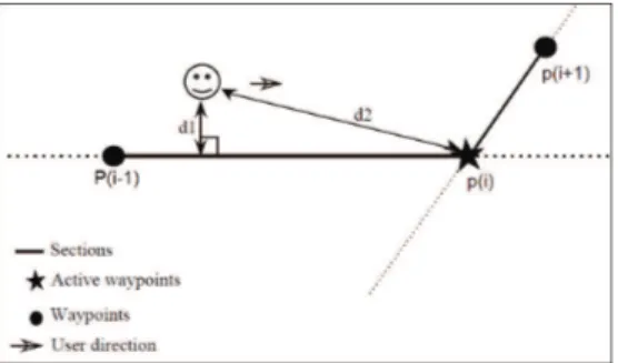
In the current study, we designed alternative waypoint validation strategies that are more flexible and robust than the capture radius strategy. The first one is called Dis-tance to Sections (D2S) and is presented in Fig.2. In this strategy, a waypoint is reached when the distance to the next section of the itinerary (d2) is smaller than the distance to the current section (d1). d1 and d2 are computed as presented in Fig.2.
Fig. 2. Distance to Sections strategy (D2S). d1 is the shortest distance between the user position
estimate and the current section. d2 is the distance between the user position estimate and the current waypoint. The current waypoint is validated as soon as d2 is smaller than d1.
The second strategy is called Distance to Lines (D2L). This strategy is an alterna-tive to the previous one where the different sections of the itinerary are virtually ex-tended with “lines”. A waypoint is reached when the distance to the next line (d2) is smaller than the distance to the current line (d1) as presented in Fig.3.
Fig. 3. Distance to Line strategy (D2L). d1 is the shortest distance between the user position
estimate and the current section. d2 is the shortest distance between the user position estimate and the next line. The current waypoint is validated as soon as d2 is smaller than d1.
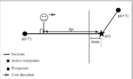
In the third strategy, called Distance to Threshold (D2T), the user position is or-thogonally projected onto the current section. The waypoint is validated when the distance between the projected point and the current waypoint is smaller than a prede-fined threshold (see Fig.4).
Fig. 4. Distance to Threshold (D2T). The user position is orthogonally projected onto the
cur-rent section. The curcur-rent waypoint is validated as soon as the distance to the waypoint (dpi) is smaller than a predefined distance (dmin).
In order to evaluate the efficacy and robustness of these three new strategies, we performed an experiment in a virtual environment. In the following section, we present the protocol and discuss the results.
4
Evaluation of the Waypoint Validation Strategies
The evaluation has been performed within SIMU4NAV [9], a multimodal virtual environment subserving the design of Electronic Orientation Aids for the Blind and developed in the context of the NAVIG project [5]
4.1 SIMU4NAV
SIMU4NAV is a multimodal virtual environment developed in order to assist EOA designer to perform evaluations in controlled conditions before onsite implementa-tion. The device presents two distinct modes: a Control mode and an Exploration mode. The Control mode is used by designers, researchers, and O&M instructors. This mode allows creating and modifying Virtual Environments (VE). A key feature of the Control mode is the possibility to import XML files (e.g. from Open Street Map) to create a 3D virtual map that corresponds to a real place. This makes it easy to import maps of real neighborhoods or cities. Another function allows manual or au-tomatic selection of starting and destination points, as well as paths between them. The Control mode also includes a feedback editor to assign arbitrary tactile and/or auditory feedback to any event in the VE. The Evaluation mode allows researchers to record the events and user's behavior, with a function to replay all of them later. More precisely, the system records, in a text file, all the information concerning the interac-tions (keystrokes, joystick, audio, haptic stimuli), as well as the avatar’s position, orientation and speed.
Two empirical observations were also modelled in SIMU4NAV. First, in a real en-vironment, a blind pedestrian who intends to move along a straight path typically deviates about 10% to the right or to the left. An adjustable drift has been added to the
avatar's displacement to simulate this behavior. Second, EOAs usually rely on GNSS positioning which accuracy may vary depending on environment. A random position-ing error – within adjustable range – was added to the position of the avatar in the VE to account for GNSS error.
The visual output of the VE - for the experimenter only - displays different textures applied to the surfaces (building, etc.) or the objects (e.g. tar texture for roads) en-countered in the VE. The platform was implemented in C++ and the rendering was performed with OGRE 3D engine.
4.2 Protocol
For the current study, we designed a guidance task within a fictional virtual environ-ment. Four pre-defined routes were generated within SIMU4NAV. Each route was 225 m long and composed by the same number of turns (1* 0° (no turn), 1*30°, 2*60°, 2*90°, 2*120° and 1*150°) and sections (lengths: 1*40 m, 5*25m and 4*15m). Routes were randomly generated to ensure that learning could not affect the results. Each validation strategy was randomly assigned to one route.
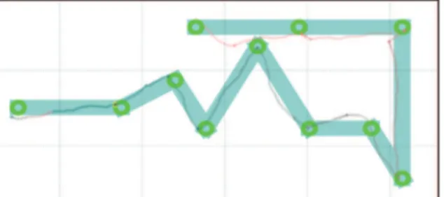
Sixteen blindfolded subjects gave their written informed consent to participate in this study. They were aged between 22 and 48 (mean: 28.7 years). They were seated in front of a keyboard and equipped with headphone. They were able to move within the VE using keyboard arrows. During a session, each blindfolded subject followed a total of 4 routes, each one with a different waypoint validation strategy. Users were guided with a virtual 3D sound that was placed over the waypoint to reach. When the current waypoint was validated, the next one was indicated. All subjects’ trajectories were logged in a text file and then analyzed. Fig. 5 illustrates the travel of one subject with the capture radius strategy.
Fig. 5. Example of itinerary and journey performed with the capture radius validation strategy.
Green circles present the capture radius around the waypoints. Blue segments are sections be-tween waypoints. User position is represented with successive crosses (color is shifted towards red with increasing locomotion speed).
4.3 Results
As presented in figure 6, the average distance traveled (16 subjects) was significantly different across the four validation strategies (Anova: F(3, 56)=5.87, p<0.001). A
Fisher LSD post-hoc test showed that the capture radius strategy induced significantly longer path compared to the three other strategies (see Fig.6). However, there was no significant difference between the three new strategies.
Fig. 6. Average (16 subjects) total distance across the different validation strategies. The total
distance is significantly higher for the capture radius strategy than for the three other.
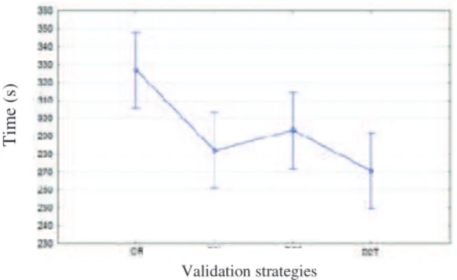
We also noticed that the average time to complete the journey was significantly different depending on the strategy used (Anova: F(3, 56)=8.93, p<0.0001). The Fish-er LSD post-hoc test showed that the capture radius strategy induced significantly longer travel times compared to the three other strategies (see Fig.7).
Fig. 7. Average (16 subjects) duration of travel across the different waypoint-validation strategies.
Travel duration is significantly higher for the capture radius strategy than for the three other.
5
Conclusions and Discussion
The results presented here show that it is possible to significantly decrease travel time and travel distance when the waypoint validation strategy used in an EOA is
Validation strategies T im e (s ) D is ta n ce ( m ) Validation strategies
improved. According to Golledge [10], the distance is the first criteria considered by the visually impaired people when choosing a path, and then time spent on route. As we have shown here, when the behavior of the blind pedestrian (angular drift) and the error in positioning are considered -which was not the case in [10]-, the “capture ra-dius” strategy is clearly not optimal. The three alternative strategies proposed here are more efficient and more robust to positioning inaccuracies and would probably pro-vide better guidance in EOAs.
We think that the proposed strategies are more flexible than ‘capture radius’ be-cause they put less constraints on the mobility of blind users. Indeed, waypoint valida-tion is less conservative, and the guided pedestrian is able to make his own choices without being forced to go through specific places (virtual circle). In addition, we eliminate the tricky issue of choosing the correct capture radius value.
Obviously, we need to confirm these results with blind users guided by an EOA in real conditions (e.g. with the NAVIG system [5]). Additional evaluation could also be performed in different mobility situations; the most important point would be to check that using the guide-dog or the long cane does not make any difference. We would then be able to define which specific strategy to use among the three new ones ac-cording to the circumstances. A dynamic switch between strategies depending on the situation and positioning uncertainty could also be an elegant solution.
References
1. Loomis, J.M., Golledge, R.G., Klatzky, R.L., Speigle, J.M., Tietz, J.: Personal guidance system for the visually impaired. In: First Annual ACM Conference on Assistive Technol-ogies - Assets 1994, pp. 85–91. ACM Press, New York (1994)
2. Brabyn, J.A.: New developments in mobility and orientation aids for the blind. IEEE Trans. Biomed. Eng. 29, 285–289 (1982)
3. Nam, Y.: Map-based Indoor People Localization using an Inertial Measurement Unit. J. Inf. Sci. Eng. 1248, 1233–1248 (2011)
4. Brilhault, A., Kammoun, S., Gutierrez, O., Truillet, P., Jouffrais, C.: Fusion of Artificial Vision and GPS to Improve Blind Pedestrian Positioning. In: International Conference on New Technologies, Mobility and Security (NTMS 2011), pp. 1–5. IEEE (2011)
5. Katz, B.F.G., Kammoun, S., Parseihian, G., Gutierrez, O., Brilhault, A., Auvray, M., Truil-let, P., Thorpe, S., Jouffrais, C.: NAVIG: Augmented reality guidance system for the vi-sually impaired. Virtual Real. J. 16, 253–269 (2012)
6. Golledge, R.G., Klatzky, R.L., Loomis, J.M., Speigle, J.M., Tietz, J.: A geographical in-formation system for a GPS based personal guidance system. Int. J. Geogr. Inf. Sci. 12, 727–749 (1998)
7. Heuten, W., Henze, N., Boll, S., Pielot, M.: Tactile wayfinder: A non-visual support sys-tem for wayfinding. In: Proceedings of the 5th Nordic Conference on Human-Computer Interaction: Building Bridges, pp. 172–181. ACM Press, New York (2008)
8. Walker, B., Lindsay, J.: Navigation performance with a virtual auditory display: Effects of beacon sound, capture radius, and practice. J. Hum. Factors 48, 265–278 (2006)
9. Kammoun, S., Macé, M.J.-M., Jouffrais, C.: Multimodal Virtual Environment Subserving the Design of Electronic Orientation Aids for the Blind. In: Proceedings of the 2012 ACM Symposium on Virtual Reality Software and Technology, pp. 189–190. ACM Press (2012) 10. Golledge, R.: Path selection and route preference in human navigation: A progress report
![Fig. 1. Capture radius strategy [8]. The waypoint is considered as validated when the pedestrian crosses the virtual circle](https://thumb-eu.123doks.com/thumbv2/123doknet/3507864.102624/4.892.307.589.712.879/capture-strategy-waypoint-considered-validated-pedestrian-crosses-virtual.webp)