UNCORRECTED
PROOF
Geomorphology xxx (xxxx) 107424Contents lists available at ScienceDirect
Geomorphology
journal homepage: http://ees.elsevier.comPlio-Quaternary landscape evolution in the uplifted Ardennes: New insights from
26
Al/
10
Be data from cave-deposited alluvium (Meuse catchment, E Belgium)
Gilles Rixhon
a,b,⁎, Régis Braucher
c, Didier L. Bourlès
c, Alexandre Peeters
d, Alain Demoulin
d,e,
Laetitia Léanni
c, Georges Aumaître
c, Karim Keddadouche
caLaboratoire Image, Ville, Environnement (LIVE UMR 7362), Université de Strasbourg, 3 rue de l'Argonne, 67000 Strasbourg, France bEcole Nationale du Génie de l'Eau et de l'Environnement de Strasbourg (ENGEES), 1 quai Koch, 67000 Strasbourg, France
cCentre Européen de Recherche et d'Enseignement de Géosciences de l'Environnement (CEREGE), Technopôle de l'Arbois-Méditerranée, BP80, 13545 Aix-en-Provence, France dDepartment of Geography, University of Liège, Clos Mercator 3, Liège 4000, Belgium
eF.R.S.-FNRS, Rue d'Egmont, 5, Brussels 1000, Belgium
A R T I C L E I N F O
Article history: Received 18 April 2019
Received in revised form 7 September 2020 Accepted 7 September 2020
Available online xxx Keywords Landscape evolution Cave-deposited alluvium 26Al/10Be burial dating River incision
A B S T R A C T
Despite a wealth of recent studies dealing with the evolution of the drainage network in the uplifted Ardennes massif (E. Belgium), especially from the Middle Pleistocene onwards, the Ardennian landscape evolution and long-term incision rates in the Meuse catchment remain poorly documented over the whole Plio-Quaternary. Al-luvium-filled multilevel cave systems represent a relevant setting to unravel the Late Cenozoic history of regional river incision. We present here a dataset of26Al/10Be concentration data obtained from fifteen pebble samples
washed into the Chawresse system, one of the largest multi-level cave systems of Belgium, which developed in Devonian limestones of the lower Ourthe valley, the main Ardennian tributary of the Meuse. The sample collec-tion spans an elevacollec-tion difference higher than 120 m and their depleted26Al/10Be ratios yield burial ages
rang-ing from ~0.25 to 3.28 Ma. After critical assessment of our dataset for intra-karstic reworkrang-ing issues, the most striking outcome of the obtained burial ages is the acceleration by a factor five of the incision rates (from ~30 to ~150 m/Ma) during the first half of the Middle Pleistocene. Integrating this incision peak and our pre-burial denudation rates, we then revisit the existing framework of Plio-Quaternary denudation and river incision in the Ardennian Meuse catchment. Whilst our26Al/10Be concentration data shed new light on the temporal and spatial
variability of the local river and hillslope system response to coupled tectonic and climatic forcings, it simultane-ously highlights sampling issues and the need for further chronological data.
© 2020
1. Introduction
Beyond studies embracing the western part of the Rhenish shield (e.g., Meyer et al., 1983; Demoulin and Hallot, 2009), the Neo-gene and Quaternary landscape evolution of the Variscan Ardennes mas-sif, i.e., its westernmost area, has long been a core topic of western Eu-rope geomorphology. In this framework, the Ardennian Meuse catch-ment has received particular attention (Davis, 1895). The first geomor-phic works focused on either Cenozoic erosion surfaces (e.g., Alexan-dre, 1976; Demoulin, 1995) or Quaternary river terrace systems of the Meuse (e.g., Macar, 1975; Juvigné and Renard, 1992; Pis-sart et al., 1997) and its Ardennian tributaries (e.g. Ek, 1957; Ju-vigné, 1979; Cornet, 1995). However, most of them did not go much
⁎Corresponding author at: Laboratoire Image, Ville, Environnement (LIVE UMR 7362), Université de Strasbourg, 3 rue de l'Argonne, 67000 Strasbourg, France.
E-mail address: gilles.rixhon@live-cnrs.unistra.fr (G. Rixhon)
beyond the mere reconstruction of successive landform generations. During the last twenty years, studies based on DEM analysis, modern dating methods, and numerical modelling have provided new insights into the quantitative long-term evolution of the Ardennian Meuse catch-ment. They allowed, for instance, the determination of sediment bud-gets (Van Balen et al., 2000) and palaeodenudation rates (Schaller et al., 2002, 2004; Demoulin et al., 2009), dating of river terrace deposits (Rixhon et al., 2011, 2014), modelling of knickpoint propa-gation (Beckers et al., 2014) and hillslope denudation (Bovy et al., 2016).
Despite these significant advances, the timing of Ardennian land-scape evolution over the Plio-Quaternary remains poorly documented (Rixhon and Demoulin, 2018). In this respect, although the Ar-dennes massif is well-known for hosting spectacular cave systems devel-oped in Paleozoic limestone formations at the outskirts of its siliceous core, such as the Han-sur-Lesse cave (e.g., Quinif and Hallet, 2018), little effort has been made so far to use this favourable setting to unravel long-term landscape evolution. Importantly, multi-level cave https://doi.org/10.1016/j.geomorph.2020.107424
UNCORRECTED
PROOF
2 G. Rixhon et al. / Geomorphology xxx (xxxx) 107424
systems may record massif-scale fluvial history. Penetrating into the karstic system as bedload of sinking streams, sediments may be left be-hind as flowing water abandons the cave when diversion of the un-derground stream to a lower topographic level occurs (Anthony and Granger, 2007). As they point to the last period of time during which the passage was at the local water table, fluvial sediments deposited in higher-lying abandoned phreatic passages, mimicking alluvium-mantled terrace sequences (Granger et al., 1997), are useful archives to un-ravel the timing of river incision. In this respect, in situ-produced cos-mogenic nuclides are a powerful tool to quantify the pace of long-term river incision (e.g., Rixhon et al., 2017), either through depth-profile dating of alluvial terraces (e.g., Repka et al., 1997) or burial dating of fluvial sediments washed into caves (e.g., Granger et al., 1997). Here, we apply this last approach.
This study explores whether past episodes of fluvial base-level sta-bility in the Ardennes can be chronologically constrained via26Al/10Be
burial dating of ancient, alluvium-filled karstic passages in one of the largest multi-level cave systems of Belgium. Coarse fluvial sediments were sampled for 10Be and 26Al measurements in the so-called
Chawresse system located in the lower Ourthe Valley (i.e., the largest Ardennian tributary of the Meuse), whose karstic levels span an eleva-tion range >120 m. We thereby primarily aim to constrain long-term incision rates at the northern rim of the uplifted Ardennes massif. Com-plementing the existing ~0.4 Ma age of the younger main terrace in the lower Ourthe Valley (Rixhon et al., 2011), new26Al/10Be burial ages
ranging from ~0.2 to 3.3 Ma extend the reconstructed incision history to the Plio-Quaternary. In addition,26Al/10Be ratios provide pre-burial
denudation rate estimates.
2. Geologic and geomorphic setting of the study area 2.1. Late Cenozoic uplift of the Rhenish-Ardennes massif
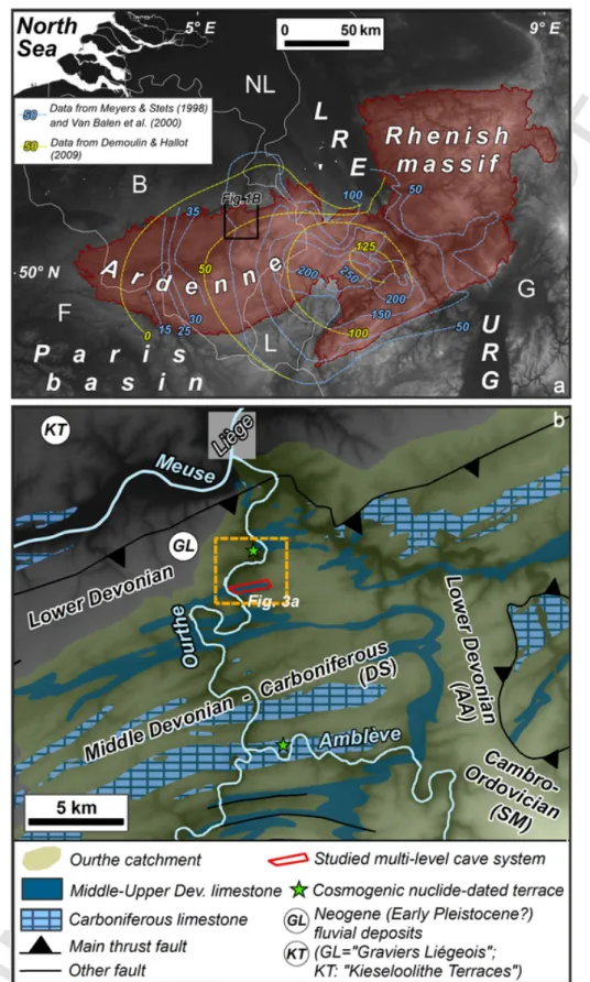
The Ardennes constitutes the western part of the Paleozoic Rhenish massif in southeastern Belgium (Fig. 1a). The whole Ardennes-Rhenish massif experienced Late Cenozoic tectonic uplift, claimed to have been caused by either lithospheric thinning (e.g., Prodehl et al., 1995), lithospheric folding (e.g., Cloetingh et al., 2005), or mantle upwelling beneath S. Eifel (Ritter et al., 2001). Whereas the spatial pattern of mid-Pleistocene uplift has been usually interpreted as an epeirogenic dome centered on the Eifel (Meyer and Stets, 1998; Van Balen et al., 2000), Demoulin and Hallot (2009) recently suggested that an up-lift pulse migrated northwards across the massif, pointing to lithospheric folding as the primary cause of uplift.
About 400–450 m of rock uplift has been inferred for the Rhenish massif since the Oligocene (Demoulin and Hallot, 2009). Up to 150 m deep Quaternary river incision in the Ardennes bears witness to a re-cently increased uplift pace probably occurring in two steps, first at the Pliocene-Pleistocene transition and then sometime at the beginning of the Middle Pleistocene (Van Balen et al., 2000). During this last, short-lasting uplift pulse (probably a few 104yr), rock uplift peak rates
may have reached 0.3 to 0.5 mm/yr (Fig. 1a; Van Balen et al., 2000; Demoulin and Hallot, 2009; Rixhon and Demoulin, 2018). A phase of tectonic quiescence is postulated from the late Middle Pleistocene on-wards (Van Balen et al., 2000).
2.2. The Ourthe catchment and its lower valley reach
The Ourthe, largest Ardennian tributary of the Meuse, joins it at the northern rim of the massif in Liège at an elevation of ~60 m (Figs. 1b and 2). Its ~3600 km2catchment is characterized by a highly
asym-metric drainage network, the main stem closely following its west-ern border. From south to north, the Ourthe Valley is incised into the siliceous Lower Devonian basement of the Ardennes anticlinorium and rock strata of the Dinant Synclinorium, including limestone formations
of the Middle/Upper Devonian and Carboniferous at several locations (Fig. 1b). Owing to sustained karstification processes, many large cave systems developed directly along the Ourthe Valley in both Devonian (Bohon, Hotton, Chawresse caves; e.g., Bastin et al., 1988) and Car-boniferous limestone formations (Abîme, Nou Bleu caves; e.g., Peeters and Ek, 2018).
The ~30 km long lower reach of the Ourthe Valley records a Late Cenozoic incision amounting to a maximum of >130 m (Cornet, 1995). Previous geomorphic works reconstructed up to 20 terrace lev-els along this reach (Ek, 1957; Cornet, 1995) (Fig. 2). However, these reconstructions are essentially descriptive and lack reliable chronolog-ical data to constrain the timing of river downcutting. The lowest ter-race at Tilff is dated by the presence of the Early Glacial Rocourt tephra (0.074–0.090 Ma), close to the study area (Juvigné, 1973; Pouclet et al., 2008), thereby suggesting a mean incision rate in the order of 40 m/Ma since the onset of the last glaciation. The only other numeri-cal age, obtained by Rixhon et al. (2011) via a10Be depth profile, is
0.39 ± 0.04 Ma for the abandonment time of the Younger Main Terrace (YMT) of the Ourthe at Colonster (~3 km downstream of the Chawresse area). The YMT is a fundamental marker in the Ardennian valleys be-cause it is located at the hinge between the broad Early Pleistocene up-per part of the valleys' transverse profile and their nested deeply in-cised Middle Pleistocene lower part (Rixhon and Demoulin, 2018). The YMT tread is perched ~55 m above the modern floodplain (all rel-ative elevations provided hereafter refer to the level of the Ourthe mod-ern floodplain at the Chawresse confluence), yielding a mean incision rate of 141 ± 15 m/Ma in this reach since 0.39 Ma.
As for mean denudation rates in the Ardennes, Schaller et al. (2004) calculated rates increasing from 30 m/Ma before 0.7 Ma to 60–80 m/Ma after that time, based on the10Be content of terrace
sed-iments whose age is estimated using a MIS correlation. These rate es-timates, however, refer to the timespan of hillslope erosion preceding sediment deposition in the valley bottom. By contrast, Demoulin et al. (2009) inferred a lower average rate of 27 m/Ma since ~0.7 Ma over the entire Ourthe catchment, based on geomorphic estimates of river in-cision and interfluve denudation.
2.3. The Chawresse multi-level cave system
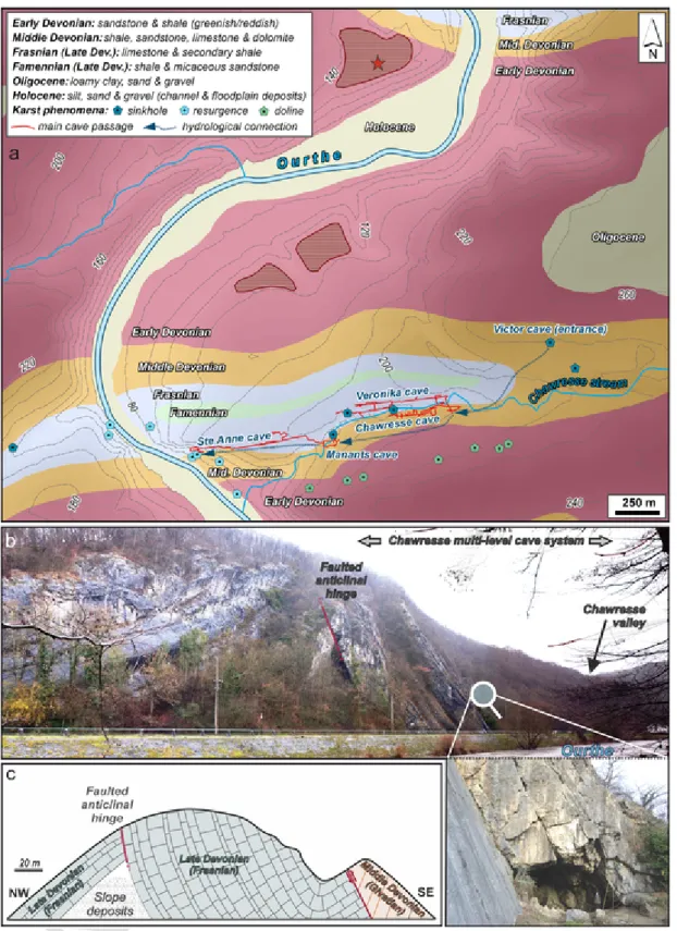
Located ~12 km upstream of the Ourthe-Meuse confluence at Liège (Figs. 1b and 2), the partly subaerial, partly subterraneous Chawresse stream is a small tributary deeply incised into the eastern valley side of the lower Ourthe. Its tiny catchment (~3 km2) comprises Lower/
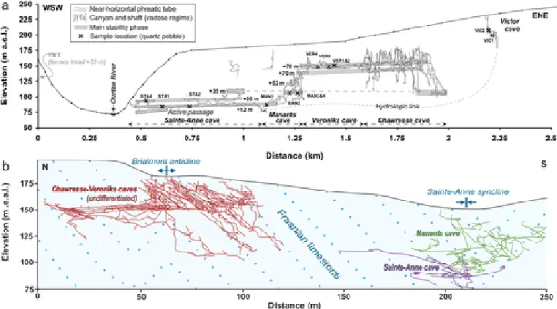
Middle Devonian siliceous rocks in the headwaters area and Upper De-vonian limestone in its downstream part (Fig. 3a). It hosts one of the largest and best-documented multi-level cave systems of Belgium in strongly folded and faulted Frasnian limestone (e.g. Ek, 1961; Ek and Poty, 1982; De Bie, 2013) (Fig. 3b–c). We will call it here-after the Chawresse cave system. It stretches in the WSW-ENE Chawresse Valley to more than 1.5 km from the confluence, includes more than 10 km of karstic galleries and shafts, and spans a total elevation dif-ference exceeding 135 m (De Bie, 2013; Fig. 4). Along with sec-ondary, smaller caves, the interconnected Chawresse system encom-passes five main cave developments named Victor, Chawresse, Veronika, Manants and Sainte-Anne, from the highest to the lowest. According to De Bie (2013), the total length and vertical height difference of each of these caves amount to ~180 and ~47 m (Victor), ~5650 and ~81 m (Chawresse and Veronika taken as a single development, see below), ~1650 and ~67 m (Manants) and ~1750 and ~35 m (Sainte-Anne). Their interconnection is attested either by narrow passages such as be-tween Chawresse and Veronika (leading De Bie, 2013 to propose a single development stage for these two caves) or by fluorescent dye
UNCORRECTED
PROOF
G. Rixhon et al. / Geomorphology xxx (xxxx) 107424 3
Fig. 1. a. Location of the Paleozoic Ardennes/Rhenish massif in northern Europe (reddish area), with blue and yellow dashed lines referring to the estimated amount of uplift (m) since the beginning of the Middle Pleistocene (Demoulin and Hallot, 2009 explicitly referring to the tectonic component of uplift). LRE: Lower Rhine embayment; URG: Upper Rhine graben. b. Simplified geological map of the northern Ourthe catchment, highlighting the two main karstified limestone formations. The investigated Chawresse multi-level cave system is located with the red frame. Remnants of the oldest alluvial deposits in this area (“Graviers Liégeois-GL”) and the oldest terraces deposits of the Meuse (“Kieseloolite Terraces-KT”) are located by white circles. AA, DS, and SM refer to Ardennes Anticlinorium, Dinant Synclinorium and Stavelot Massif, respectively. The dashed orange rectangle refers to Fig. 3a. (For interpretation of the references to color in this figure legend, the reader is referred to the web version of this article.)
UNCORRECTED
PROOF
4 G. Rixhon et al. / Geomorphology xxx (xxxx) 107424
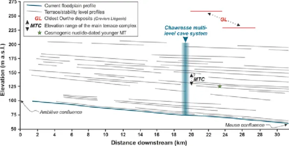
Fig. 2. Lower Ourthe Valley: longitudinal profile of the modern floodplain and previous stability levels (up to 20 different according to Cornet, 1995), chiefly inferred from terrace remnants and karstic phreatic tubes, such as those from the Chawresse multi-level system (see Fig. 4). The profile reconstruction is modified from Cornet (1995).
tracing such as between Victor and Sainte-Anne (Fig. 4; Supplementary material 1).
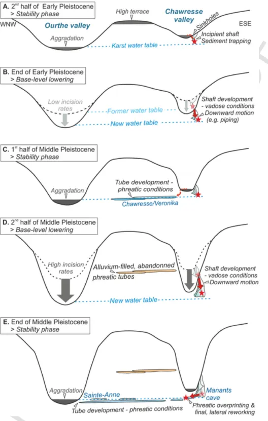
Speleogenetic studies in the Chawresse system agree to highlight the presence of well-developed, abandoned subhorizontal phreatic tubes at different elevations, usually exhibiting an elliptical cross section, as the main morphological feature (Ek, 1961, 1964; Ek and Poty, 1982; De Bie, 2013) (Fig. 5a). These tubes constitute most of Sainte-Anne (at ~12 and 20 m relative elevation, see e.g., Ek, 1964) and Veronika, with extensions into the Chawresse cave (at ~70 and 75–78 m relative eleva-tion, see De Bie, 2013). The polycyclic nature of these phreatic levels has long been recognized in Sainte-Anne (Ek, 1961) and may be as-sumed for the whole system, matching a per descensum model of kars-tification (Harmand et al., 2017). In the frame of a tectonically con-trolled gradual base-level lowering, authors agree that there is a mor-phogenic correlation between cave development and the subaerial ter-race sequence in the lower Ourthe Valley (Ek, 1961; Quinif, 1989; Cornet, 1995). (See Fig. 6.)
The main abandoned phreatic tubes in the Chawresse and Veronika caves are roughly located at the same relative elevations, but vadose shafts and canyons, almost absent in Veronika, build an intricate net-work in the Chawresse cave (Fig. 4). Although similarity of elevation favours the hypothesis of a single stage of cave development, the trast in shaft and canyon density argues against it, though this con-trast might be controlled by the local geological structure. Indeed, whereas the main phreatic passages of Veronika stretch along the anti-clinal hinge, all developments of the Chawresse cave are located within the steeply dipping southern limb of the anticline, ~50 m more to the south. The Manants cave, which seems to have developed geographi-cally apart from the other cave systems, is dominated by abundant va-dose shafts and canyons. The bulk of these occur in the southern wall of the Chawresse Valley, spanning >65 m of elevation difference sim-ilar to those of the Chawresse cave (Fig. 4). The current entrance of the Manants cave corresponds to an active sinkhole in the sub-aerial Chawresse streambed (Figs. 3a and 4b). At the base of the cave de-velopment, poorly developed phreatic tubes are aligned along the ENE continuation of the main phreatic developments of the Sainte-Anne cave (Fig. 4). Caver explorations report an intricate underground topogra-phy for the Manants karstic system (De Bie, 2013). A peculiarity of Sainte-Anne is that the ceiling of one of the phreatic tubes displays a >1 m high dissolution feature, which might have been caused by sediment accumulating in this formerly water-filled passage and in
ducing upward dissolution of the tube's ceiling (i.e., paragenesis, Far-rant, 2004; see Fig. 5b). This indicates that the alluvium that once filled this passage could have been almost completely evacuated by the underground Chawresse stream as a response to a later drop of the wa-ter table.
3. Sampling strategy and26Al/10Be burial dating
A two-step scenario constitutes the basic prerequisite of burial dating applied to cave-deposited alluvium, namely exposure at the (sub-)sur-face followed by a rapid and complete burial at a depth great enough (practically, >20 m of overburden) to efficiently prevent any postbur-ial muonic production (e.g., Granger, 2014). It also assumes that, once the clastic sediments had entered the underground karstic system, they suffered no erosion or underground reworking (e.g., Rixhon, 2016). Therefore, wherever possible (i) we primarily targeted cave passages where clastic infills were massively preserved (as in the Veronika cave, see Supplementary material 1), (ii) we preferentially sampled under-ground sediments that still exhibit original tiling and bedding structures in the abandoned phreatic tubes (Fig. 5c–d) and (iii) we avoided de-posits for which reworking could obviously be suspected (for instance, those located close to active passages of the underground Chawresse stream). Given the generally coarse size of the cave sediments, the peb-ble fraction was selected (Supplementary material 1). Altogether, fifteen quartz-bearing samples, chiefly quartz pebbles with subsidiary quartzite pebbles, were collected (Fig. 5d; Supplementary material 2). Twelve out of the fifteen processed samples were single clast samples, the three others, all extracted from the Manants cave (MAN1, 2 and 3bis), were amalgamated samples (Table 1, Supplementary material 2). Whilst two samples were taken in the Victor cave at relative elevations of ~125 and 135 m, we purposely collected more samples in the main phreatic devel-opments of the lower-lying cave levels in order to strengthen the timing of the main phases of fluvial base-level stability in the lower Ourthe Val-ley (Fig. 4 and Table 1). We thus collected four or five samples from the Veronika cave (relative elevation of ~72 to 75 m), the Manants cave (~15 to 35 m) and Sainte-Anne cave (~12 to 20 m). Note that26Al/10Be
burial dating of cave-deposited alluvium constrains the last period of time during which the passage was at the local water table. In the case of prior ghost-rock karstification (Dubois et al., 2014), this is also the time when ghost-rock feature emptying could be achieved, allowing for sediments originating from the ground surface to be brought into the passage.
UNCORRECTED
PROOF
G. Rixhon et al. / Geomorphology xxx (xxxx) 107424 5
Fig. 3. a. Geological map of the study area and the Chawresse multi-level cave system. Red dashed areas and red star refer to remnants of the younger main terrace and the sampling location for depth profile dating in the Colonster terrace (Rixhon et al., 2011), respectively. Lithology and karst phenomena are extracted from De Bie (2013) and the hydrogeological map of Wallonia (Ruthy, 2015). b. Panoramic view of the folded Frasnian limestone from the western Ourthe Valley wall (photo: G. Rixhon). The entrenched Chawresse Valley is visible to the south. The spectacular Sainte-Anne cave's entrance is perched ~17 m above the current river channel (see the person for scale; photo: G. Rixhon). c. Simplified geological sketch of the eastern valley side alongside the main road (adapted from Ek, 2007). (For interpretation of the references to color in this figure legend, the reader is referred to the web version of this article.)
The burial duration is estimated from measurements of the26Al/10Be
ratio, which decreases with burial time according to the different disin-tegration rates of the two radionuclides (e.g., Dunai, 2010;
Rixhon, 2016; see Supplementary material 3 for mathematical devel-opment). In this study, we used half-lives of (1.387 ± 0.012) × 106and
(0.705 ± 0.017) × 106yr for 10Be and 26Al, respectively (Granger,
UNCORRECTED
PROOF
6 G. Rixhon et al. / Geomorphology xxx (xxxx) 107424
Fig. 4. Cross sections of the lower Ourthe Valley with the projected cave levels of the Chawresse multi-level system. a. WSW-ENE-oriented, topographic cross section exhibiting the loca-tion of the fifteen samples (quartz and quartzite pebbles) collected from the oldest cave system (Victor) to the youngest (Sainte-Anne). The underground topography is adapted from Ek (1961) for the Sainte-Anne cave and De Bie (2013) for all other cave levels. The elevation of the Younger Main Terrace (YMT) is also reported. b. Simplified, N-S-oriented, geological cross section (quasi-perpendicular to that of Fig. 4a). Note the relationship between local structure and cave development: the Chawresse/Veronika caves and the Manants/Sainte-Anne caves are mostly developed in relationship with an anticlinal and synclinal structure, respectively.Adapted from De Bie (2013).
Fig. 5. Field photos from the multi-level Chawresse cave system a. Elliptical cross section of the active phreatic tube with a twofold notch in the main level of Sainte-Anne (photo: V. Gerber). b. Probable paragenetic feature in the ceiling of a phreatic tube of Sainte-Anne (dashed red curve; photo: V. Gerber); c. Tilling structure of the elongated pebbles (dashed white arrows) indicating the palaeo-flow direction of the underground stream in the main phreatic level of Veronika (from Rixhon, 2016). d. Alternation of matrix-supported (M-S) and clast-supported (C-S) layers in river sediments filling the main phreatic tube of Veronika, and sampling location of the quartz pebble VER1 (photo: Y. Levecq). (For interpretation of the references to color in this figure legend, the reader is referred to the web version of this article.)
The chemical treatment and the AMS measurements (both 10Be and 26Al) of all samples presented in this study were carried out at the
CEREGE laboratory in Aix-en-Provence. After crushing and sieving (be
tween 1 and 0.250 mm), sediment samples passed through magnetic separation, and the non-magnetic fraction underwent selective etching in fluorosilicic and hydrochloric acids to eliminate all mineral phases
UNCORRECTED
PROOF
G. Rixhon et al. / Geomorphology xxx (xxxx) 107424 7
Fig. 6. Long-term, per descensum, speleogenetic scenario involving gradual base-level lowering and proposing an uncoupled evolution of the Chawresse/Veronika caves and Manants/ Sainte-Anne caves. It shows a stepwise intra-karsting reworking of the clasts sampled in the Manants cave (red stars), which yielded “abnormally” old burial ages (see text for further explanation). Grey arrows refer to river incision whereas thin dotted and thick red arrows represent sediment motion at the surface and in the underground karstic system, respectively. (For interpretation of the references to color in this figure legend, the reader is referred to the web version of this article.)
but quartz. Quartz minerals then underwent a series of selective etch-ings in hydrofluoric acid to eliminate potential surface contamination by
10Be produced in the atmosphere (Brown et al., 1991). The cleaned
quartz minerals were then completely dissolved in hydrofluoric acid af-ter addition in each sample of ~100 μl of an in-house carrier solution ((3.025 ± 0.009) × 10−3g9Be/g solution) prepared from a deep-mined
phenakite (Merchel et al., 2008). After substituting HF
by HNO3, an aliquot of 500 μl of the obtained solution was taken for 27Al concentration measurements. Aluminum and beryllium were
sep-arated from the remaining solution by ion-exchange chromatography and selective precipitation (Merchel and Herpers, 1999). The result-ing Be and Al precipitates were oxidized by heatresult-ing at 800 °C for 1 h and the oxides were mixed to 325 mesh niobium powder prior to mea-surements by Accelerator Mass Spectrometry (AMS). All the data re
UNCORRECTED
PROOF
Table 1Results of the10Be and26Al concentration measurements with the26Al/10Be ratios, from which the burial ages (Ma) and palaeodenudation rates (i.e., before the burial event in m/Ma) are computed. Based on an average elevation of 240 m for the Chawresse catchment, the Stone scaling factor amounts to 1.2845. No postburial production was considered. All uncertainties are 1-sigma.
Caves + sampling elevation/sample ID + naturea 10
Be/9Be Uncert. 10Be Uncert. 26Al/27Al Uncert. 26Al Uncert. 26Al/10Be Unc. Burial age Unc. Palaeoden. rate Uncert.
(atoms/g) (atoms/g) (atoms/g) (atoms/g) (Ma) (Ma) (m/Ma) (m/Ma)
Victor (~125–135 m of relative elevation)
VIC1 (sing.cl.) 4.54E−13 1.42E−14 384,317 12,047 4.86E−13 4.56E−14 459,703 43,170 1.20 0.12 3.28 0.22 1.44 0.24
VIC2 (sing.cl.) 1.23E−13 4.01E−15 112,284 3664 6.46E−13 5.35E−14 642,531 53,452 5.72 0.51 0.38 0.24 29.28 4.16
Veronika (~72–75 m of relative elevation)
VER1 (sing.cl.) 3.72E−13 1.27E−14 334,415 11,478 3.57E−13 1.88E−14 1,709,349 95,295 5.11 0.33 0.56 0.18 8.08 1.01
VER2 (sing.cl.) 7.21E−13 2.28E−14 601,930 19,161 6.62E−13 2.78E−14 3,464,437 158,767 5.76 0.32 0.26 0.15 4.97 0.55
VER3 (sing.cl.) 1.85E−12 4.30E−14 2,356,386 55,297 6.76E−12 2.06E−13 9,886,421 310,034 4.20 0.16 0.50 0.08 0.81 0.07
VER4 (sing.cl.) 1.68E−13 5.48E−15 146,529 4809 1.88E−13 1.41E−14 791,373 60,736 5.40 0.45 0.51 0.23 20.26 2.89
Manants (~15–35 m of relative elevation)
MAN1 (amalg.) 1.57E−13 5.00E−15 150,426 4825 5.61E−13 6.76E−14 595,834 72,042 3.96 0.50 1.13 0.32 14.15 2.65
MAN2 (amalg.) 3.99E−13 1.25E−14 352,449 11,115 6.12E−13 3.64E−14 1,020,973 61,616 2.90 0.20 1.66 0.17 4.14 0.51
MAN3 (sing.cl.) 3.66E−13 1.25E−14 312,034 10,703 6.80E−13 4.17E−14 853,539 52,711 2.74 0.19 1.79 0.18 4.42 0.58
MAN3bis (amalg.) 2.04E−13 6.50E−15 180,981 5776 6.33E−13 4.88E−14 619,189 47,933 3.42 0.29 1.41 0.22 9.94 1.41
Sainte-Anne (~12–18 m of relative elevation)
STA1 (sing.cl.) 2.50E−13 8.08E−15 217,928 7075 1.50E−13 1.17E−14 1,024,054 79,680 4.70 0.40 0.77 0.22 11.54 1.65
STA1bis (sing.cl.) 8.44E−13 2.88E−14 737,993 25,269 1.62E−12 6.26E−14 2,988,746 116,123 4.05 0.21 0.89 0.13 2.77 0.30
STA2 (sing.cl.) 6.27E−14 3.17E−15 62,250 3151 3.45E−13 4.62E−14 381,841 51,205 6.13 0.88 0.24 0.38 58.27 11.92
STA2bis (sing.cl.) 3.40E−13 1.16E−14 332,018 11,374 1.30E−12 6.39E−14 1,933,862 95,615 5.82 0.35 0.30 0.16 9.47 1.11
STA4 (sing.cl.) 1.51E−13 7.23E−15 132,752 6383 7.67E−14 9.21E−15 571,828 68,700 4.31 0.56 0.94 0.36 18.32 3.94
UNCORRECTED
PROOF
G. Rixhon et al. / Geomorphology xxx (xxxx) 107424 9
ported in this study have been measured at the French national facil-ity ASTER of the CEREGE. Beryllium-10 data were calibrated directly versus the National Institute of Standards and Technology standard ref-erence material NIST SRM 4325 using an assigned10Be/9Be value of
(2.79 ± 0.03) × 10−11(Nishiizumi et al., 2007). This
standardiza-tion is equivalent to 07KNSTD within rounding error. The obtained
26Al/27Al ratios were calibrated against the ASTER in-house standard
SM-Al-11 with 26Al/27Al = 7.401 ± 0.064 × 10⁻¹², which has been
cross-calibrated against the primary standards certified by a laboratory inter-calibration exercise (Merchel and Bremser, 2004).27Al
concen-trations, naturally present in the samples, were measured at CEREGE by ICP-OES. Analytical uncertainties (reported as 1σ) include uncertain-ties associated with AMS counting statistics, AMS internal error (0.5%), chemical blank measurement and, regarding26Al,27Al measurement.
Long-term measurements of chemically processed blanks yield ratios on the order of 3.0 ± 1.5 × 10⁻¹⁵for10Be and 2.2 ± 2.0 × 10⁻¹⁵for26Al
(Arnold et al., 2010).
A local10Be production rate of 5.16 g at−1yr−1was obtained
us-ing local coordinates, an average catchment elevation of 240 m and a sea-level high latitude production rate of P0= (4.02 ± 0.36) at g−1yr−1
(Stone, 2000). The latter is identical to the weighted mean of produc-tion rates in the Northern Hemisphere (Ruszkiczay-Rüdiger et al., 2016) and in agreement with recently calibrated values (Borchers et al., 2016). An26Al/10Be pre-burial, spallation production ratio
amount-ing to 6.61 was used (Nishiizumi et al., 1989; Braucher et al., 2011). Because the cave overburden is always thicker than 20 m, post-burial muon production was ignored in the burial age determina-tion.
4. Results:26Al/10Be ratios, burial ages and pre-burial denudation
rates
Cosmogenic10Be and26Al concentrations in the samples range
be-tween (0.62 ± 0.03) × 105 and (23.56 ± 0.55) × 105, and
(3.82 ± 0.51) × 105and (98.86 ± 3.10) × 105atoms g−1quartz,
re-spectively (Table 1). These concentrations yield26Al/10Be ratios (R26/ 10) between 1.20 ± 0.12 and 6.13 ± 0.88 (Table 1). Such depleted
R26/10identify a burial event for all samples. Burial ages ranging from
the Pliocene to the final part of the Middle Pleistocene were com-puted accordingly (Table 1). Pre-burial denudation rates roughly rang-ing from 1 to 58 m/Ma are simultaneously calculated (Table 1). We present hereafter the detail of these results, together with their 1σ un-certainties, obtained for the four different cave levels, from the highest to the lowest.
4.1. Victor cave
Very contrasting R26/10 characterise the samples VIC1 and VIC2:
1.20 ± 0.12 and 5.72 ± 0.51, respectively. Burial durations and pre-burial denudation rates for each sample differ accordingly: 3.28 ± 0.22 Ma and 1.44 ± 0.24 m/Ma (VIC1) versus 0.38 ± 0.24 Ma and 29.28 ± 4.16 m/Ma (VIC2).
4.2. Veronika cave
R26/10 of the four samples collected in the main phreatic passage
of the Veronika cave range from 4.20 ± 0.16 to 5.76 ± 0.32. They yield burial durations and pre-burial denudation rates ranging from 0.26 ± 0.15 to 0.56 ± 0.18 Ma and 0.81 ± 0.07 to 20.26 ± 2.89 m/ Ma, respectively. At first glance, the 0.26 Ma burial age (sample VER2) may appear out of the range of the age cluster yielded by the three other samples (~0.50–0.56 Ma). However, the large 1σ-uncertainties as-sociated to VER2 and 4 make burial ages of these two samples statis-tically indistinguishable. We therefore use the sample VER2 in further calculations. An error-weighted mean of 0.47 ± 0.06 Ma is computed
for the Veronika cave out of the four individual burial durations (remov-ing the VER2 sample from the dataset would yield a mean burial dura-tion of 0.51 ± 0.07 Ma, not much different from the previous one). 4.3. Manants cave
R26/10of the four samples collected in the Manants cave at
differ-ent elevations range from 2.74 ± 0.19 to 3.96 ± 0.50. They yield burial durations and pre-burial denudation rates ranging from 1.13 ± 0.32 to 1.79 ± 0.18 Ma and 4.14 ± 0.51 to 14.15 ± 2.65 m/Ma, respectively. Similar to the dataset from the Veronika cave, the 1σ-uncertainties as-sociated to the samples (especially MAN1 and 3bis) make their individ-ual burial ages statistically indistinguishable. An error-weighted mean of 1.59 ± 0.10 Ma is computed for the Manants cave out of the four indi-vidual burial ages.
4.4. Sainte-Anne cave
R26/10of the five samples collected in the Sainte-Anne cave at
dif-ferent elevations range from 4.05 ± 0.21 to 6.13 ± 0.88. They yield burial ages and pre-burial denudation rates ranging from 0.24 ± 0.38 to 0.94 ± 0.36 Ma and 2.77 ± 0.30 to 58.27 ± 11.92 m/Ma, respec-tively. Large differences are thus observed for both burial durations and pre-burial denudation rates in this cave level, yet consistent with the rel-ative elevation of each sample (Fig. 4a). One might argue from its lower nuclide concentration values and, consequently, the larger relative un-certainty on its26Al content that sample STA2 is not as meaningful as
the other samples in Sainte-Anne cave (Table 1). However, its calcu-lated burial duration is consistent with that of STA2bis, sampled in the exact same location. As for their strongly contrasted denudation rate es-timates, it is important to recall that they were calculated from single pebbles and thus refer to local denudation rather than mean catchment rates. When sedimentation occurred in the Sainte-Anne cave, the valleys had already been carved deep enough to display steep hillslopes where local denudation rates could be highly variable. We therefore consider the pair of burial duration estimates yielded by STA2 and STA2bis as significant.
5. Discussion
5.1. Relevance of the local speleogenesis in interpreting burial ages
Our burial age results clearly stress the necessity of collecting sev-eral samples in every individual cave system (Laureano et al., 2016; Sartégou et al., 2018). Indeed, although this procedure supports a robust dating of the Veronika cave at 0.47 ± 0.06 Ma, it was also ab-solutely required to uncover potential methodological or geomorphic is-sues in the other cave levels (Häuselmann and Granger, 2005; Dunai, 2010).
5.1.1. Contamination by younger material
The ~0.4 and 3.3 Ma burial ages obtained for the Victor cave di-verge by one order of magnitude. This large discrepancy most proba-bly results from the distinct positions of the sampling sites within the cave. Whereas the VIC1 sample was collected in the lower main de-velopment of the cave at ~125 m relative elevation, the VIC2 sample was located much nearer to the cave entrance, directly at the bottom of the uppermost underground shaft (~135 m relative elevation). At such high position above the present Ourthe River, the 0.38 ± 0.24 Ma bur-ial age is without doubt geomorphologically inconsistent. In particular, it strongly contradicts the robust10Be depth profile dating of the YMT
at Colonster, which provided an age of ~0.4 Ma for terrace deposits lo-cated 80 m below the level of the Victor cave (Rixhon et al., 2011). We thus interpret the anomalous young age of VIC2 as indicating a
UNCORRECTED
PROOF
10 G. Rixhon et al. / Geomorphology xxx (xxxx) 107424
later reactivation of the sinkhole (now in interfluve position) and injec-tion of younger sediments into the oldest karstic level of the Chawresse system. Moreover, assuming a gravitational collapse of unknown thick-ness, it is unsure whether the material originates from the surface or the sub-surface and, thereby, whether the initial R26/10of this sample does
not violate the key assumption for burial dating (see Section 3 above). Consequently, the VIC2 sample is discarded and we consider the Late Pliocene burial age of VIC1 to be representative of the time when the water table (and the Ourthe River) existed at these high elevations. 5.1.2. Probable intra-karstic reworking
The four Early Pleistocene burial ages of the Manants cave at less than 35 m relative elevation must mandatorily be addressed against the background of progressive river downcutting over the Plio-Quaternary. Based on the mid-Middle Pleistocene age of the YMT at Colonster (and, more broadly, also elsewhere in the Meuse catchment; Rixhon et al., 2011), they are substantially older than expected at such a low relative elevation. Three explanatory hypotheses may be examined, namely an alternative model of speleogenesis, a previous burial episode of the sam-pled material or an intra-karstic reworking with downward motion.
An alternative per ascensum model of speleogenesis, such as the one documented in the Ardèche Valley (e.g., Tassy et al., 2013), would con-tradict all geomorphic evidence of stepwise base-level lowering and in-cision in the entire Ardennian Meuse River network related to Quater-nary uplift (e.g., Juvigné, 1979; Pissart et al., 1997; Demoulin et al., 2012; Rixhon and Demoulin, 2018). In the lower Ourthe Valley, the well-preserved terrace staircase and its geomorphological coupling with cave systems strongly point to a per descensum model of speleoge-nesis (Harmand et al., 2018). The latter is acknowledged not only for the Chawresse system (Ek, 1961; Cornet, 1995) but also for the newly discovered Noû Bleû cave located several kilometers upstream (Peeters and Ek, 2018). The hypothesis of an alternative speleogenetic model is thus highly unlikely.
Even if no direct evidence precludes the possibility that some of the sampled material underwent a burial episode before entering the karstic system, two lines of argument point to intra-karstic reworking as the most likely cause of the ages that are too old. First, beyond exhibiting higher depletion than the Veronika samples (Table 1), the Manants R26/ 10data subset is internally consistent, with the lowest variability among
all cave levels. This points to a single burial history for all Manants sam-ples, and thus most likely an exclusively intra-karstic history. Indeed, re-working of pebbles that would have experienced subaerial burial events before entering the cave system (e.g., at the base of thick Early Pleis-tocene Ourthe terrace deposits) would probably have implied a large scatter in the depleted R26/10(different burial durations and depths).
Second, the intricate karstic system of the Manants cave dominated by vadose shafts (Fig. 4) points to multiphase speleogenetic processes (De Bie, 2013), which probably also entailed a complex underground evolution of the cave sedimentary infill. Following De Bie (2013),
who considers that the Chawresse and Veronika caves form a single sys-tem, we thus suggest that the Chawresse/Veronika and the Manants/ Sainte-Anne systems evolved independently, possibly also with some temporal overlap that might explain the complex underground topogra-phy of the Manants cave and the Early Pleistocene burial ages obtained for its cave infill. A realistic, though speculative, history of the Man-ants samples might have implied the following stages: (i) washing of sediments into dolines and/or sinkhole shafts in the vadose zone above an Early Pleistocene stability level, with substantial shielding to cosmic rays already allowing some R26/10decrease; (ii) from the late Early
Pleis-tocene, progressive base-level lowering and Ourthe and Chawresse inci-sion promoting downward development of the shafts and travel of the trapped sediments, possibly aided by piping and underground drainage, to depths possibly beyond reach of the cosmic rays; (iii) Middle Pleis-tocene stability phase inducing the independent formation and infilling of the phreatic tubes of the Veronika cave whilst the Manants clasts re-mained buried in their separate system; (iv) later in the Middle Pleis-tocene, main phase of river downcutting and renewed downward dis-placement of the sediments buried in the Manants cave, however, not affecting the fossilized Veronika tubes and their infill; (v) probably in connection with the main tube formation in the Sainte-Anne cave some-time during the late Middle Pleistocene, phreatic overprinting of the Manants cave with essentially lateral reworking bringing the clasts in their sampling position. Note that the same reasoning can be held for the older burial ages of sediments sampled in the higher phreatic tubes of Sainte-Anne, which might indicate input of older material through the Manants cave as a siphon connects both caves (Fig. 4; De Bie, 2013).
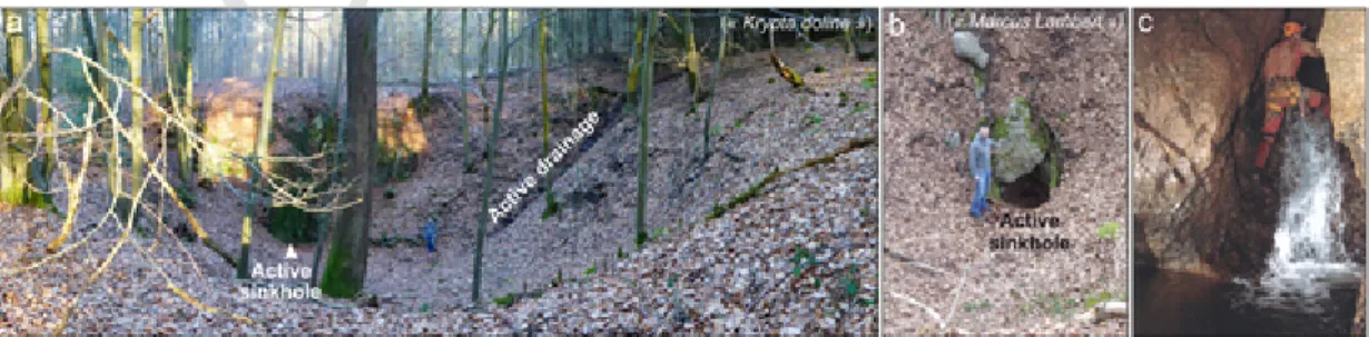
Several field observations support this scenario. A dense network of well-developed dolines (depth locally >10 m) occur directly to the south of the cave (“dolines syncline”, Fig. 7a). Located upslope south of the Chawresse Valley at elevations of 180–200 m, they display ac-tive sinkholes and sediment accumulation at their bottom (Fig. 7b). Al-though their possible hydrological connection with the Manants cave has not been explored so far (De Bie, 2013), we may postulate that similar extended vertical connection between the ground surface and deeper cave levels also existed in the past. Moreover, in contrast with all other caves of the Chawresse system, the current Manants cave's en-trance corresponds to an active sinkhole in the sub-aerial Chawresse streambed. Active drainage of the cave's vadose shafts by the under-ground stream obviously still facilitates the downward transport of clas-tic material (Fig. 7c). For all these reasons, we interpret all burial ages obtained for the Manants samples and those of STA1, 1bis and 4 in Sainte-Anne as discordant data telling corollary events of the drainage system downcutting.
Fig. 7. a & b. Series of well-developed, active dolines/sinkholes located atop the southern hillslope of the Chawresse Valley southward of the Manants cave (see location in Fig. 3a; photos: G. Rixhon). c. Active vertical drainage (i.e., underground Chawresse stream) in vadose conditions in the Manants cave (photo: P. De Bie).
UNCORRECTED
PROOF
G. Rixhon et al. / Geomorphology xxx (xxxx) 107424 11
5.2. Comparison of the burial ages with Neogene/Quaternary fluvial deposits
5.2.1. Pre-Quaternary fluvial evolution at the northern rim of the massif The 3.28 ± 0.22 Ma burial age in the Victor cave represents the first Pliocene numerical age for fluvial deposits located within the Ardenn-ian Meuse catchment. This age is consistent with the position of the Victor cave at the plateau's margin atop the eastern Ourthe Valley side (Fig. 4) and the Neogene age assigned to the lowest beveled surfaces flanking the incised Quaternary valleys (Demoulin, 1995; Demoulin et al., 2018). Moreover, the dated deposit lies at a lower elevation than the quartz- and quartzite-rich fluvial gravels discontinuously cov-ering the Ourthe/Meuse interfluve 155 to 180 m above the modern val-ley bottoms (e.g., Rixhon and Demoulin, 2010; Fig. 8a). Located ~5 km to the northwest of the Chawresse multi-level system (Fig. 1b), these gravels, locally known as “Graviers Liégeois” (Pissart, 1964), have been interpreted as the oldest Ardennian River sediments deposited by a proto-Ourthe system and tentatively dated from the Miocene (Supple-mentary material 4), based on stratigraphic and pedogenetic evidence (Buurman, 1972) (Fig. 8a). Finally, although the highest terrace rem-nants in the lower Ourthe Valley hardly reach 125 m relative elevation (Cornet, 1995), the oldest terrace deposits of the Meuse in the nearby Liege area, traditionally referred to as “kieseloolite terraces” (Macar, 1975; Supplementary material 4), occur within the same range of rel-ative elevation as the Victor cave (~115–135 m) (Fig. 8a) (Juvigné and Renard, 1992; Rixhon and Demoulin, 2018). Despite the lack of direct numerical age of the kieseloolite terraces, authors now agree that their stratigraphic correlation with the Kieseloolite Formation in the Roer Valley Graben dates them between the Late Tortonian and the Early Piacenzian (Westerhoff et al., 2008; Rixhon and Demoulin, 2018; Beerten et al., 2018; Munsterman et al., 2019). Overall, the Pliocene burial age of the Victor cave thus appears in good agreement with the available geomorphic and sedimentary evidence in the area. 5.2.2. Geomorphological and chronological link between the Veronika cave and the YMT
Our convergent burial durations in the main phreatic tubes of the Veronika cave point to a long-lasting regional base level ~70–75 m above the current valley bottom around 0.47 Ma. At this elevation, the cave lies 15–20 m above the YMT of the Ourthe (Fig. 9). The
10Be depth profile performed in the YMT sediments at Colonster, 3 km
downstream of the Chawresse cave system, reliably dated the terrace abandonment time at ~0.39 Ma (Rixhon et al., 2011), which is at first glance in perfect agreement with the ~0.5 Ma age of the Veronika cave level.
However, the story is somewhat more complex. First, in the lower Meuse ~20 km north of Liege, the abandonment time of the Romont terrace, formerly correlated to the YMT (Juvigné, 1992), was dated at 0.73 ± 0.12 Ma via a twofold10Be and26Al depth profile (Rixhon et
al., 2011). The later reassignment of this terrace to the next higher level within the Main Terrace Complex led Rixhon and Demoulin (2018) to propose a younger age around 0.62 Ma for the YMT aban-donment time in this valley reach. Second, ~20 km upstream of the Chawresse area, another10Be depth profile in terrace deposits of the
Amblève River close to its confluence with the Ourthe (Fig. 1b) re-vealed that, although the YMT was abandoned at 0.22 ± 0.03 Ma in that place, it had started to aggrade much earlier, around 0.58 Ma (Rix-hon et al., 2011). Broadly consistent with the YMT age at Romont, the latter age thus implies that the lower Ourthe River had also already in-cised its valley down to slightly less than 55 m of relative elevation (i.e., the base of the YMT) around 0.58–0.62 Ma. This seems to contradict the younger 0.47 ± 0.06 Ma mean burial age obtained in the higher-located Veronika cave.
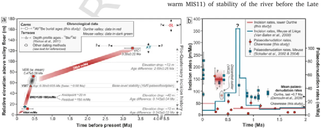
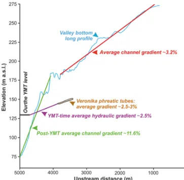
This apparent discrepancy finds its explanation in the location of the Veronika cave in the Chawresse Valley, about 800 m upstream of the Ourthe confluence, which, at YMT time, was approximately super-posed to the present one. Therefore, we interpret the 15–20 m eleva-tion difference between the cave and the Ourthe YMT as expressing the hydraulic gradient beneath the hillslopes east of the Ourthe at YMT time. This ~2.5% gradient is very close to the 2.5–3% westward slope of the Veronika main galleries (Fig. 9) and the ~3% slope of the sub-aerial channel in the upper Chawresse inherited from the Early Pleis-tocene, the Middle Pleistocene incision wave having not reached the upper Chawresse (Beckers et al., 2015). So connecting the Veronika cave, and thus making it contemporaneous, with the Ourthe YMT is geomorphically and chronologically consistent. Once the Ourthe River had started to develop its YMT floodplain sometime between 0.62 and 0.58 Ma, the Veronika karstic level in turn began to form following the hydraulic gradient of the time. Clasts sampled in the upper part of a ~2-m thick deposit date the later filling of its galleries around 0.47 Ma, i.e., well before the YMT level was abandoned through renewed Our-the incision around 0.39 Ma in this area (Rixhon et al., 2011). We also note that the YMT time was the last long period (including the long warm MIS11) of stability of the river before the Late Pleistocene, so
Fig. 8. Long-term fluvial landscape evolution at the northern rim of the Ardennes in the main trunk (Meuse) and its main tributary (Ourthe). a. Computation of Plio-Quaternary incision rates based on the26Al/10Be burial ages from this study and from compilation of existing ages (see references in figure insert and text). Note the one order magnitude change in the Ourthe Valley and the sustained incision pulse recorded during the Middle Pleistocene. GL (i.e., oldest proto-Ourthe deposits) and KT (i.e., oldest Meuse terraces) refer to Neogene/Quaternary fluvial deposits located in Fig. 1b. Vertical and horizontal dashed black arrows refer to their elevation range and supposed time range (with question marks), respectively. b. Compilation of incision and palaeodenudation rates. Note that the incision pulse in the lower Ourthe occurred later than the incision peak in the main trunk, which is characterized by questionable very high rates (>350 m/Ma, see text). As for the discarded outlier, see text for further information. Age uncertainties relative to palaeodenudation data are not provided for a matter of clarity.
UNCORRECTED
PROOF
12 G. Rixhon et al. / Geomorphology xxx (xxxx) 107424
Fig. 9. Morphometric characteristics of the Chawresse tributary (note the well-marked hanging valley sensu Wobus et al., 2006) and gradient relationship between the Veronika Cave and the Ourthe YMT level.
that one could a priori expect it would have been favourable to such a large karstic development as that of the Veronika cave.
5.3. Incision rate variability over the Plio-Quaternary
The10Be-based ages obtained by Rixhon et al. (2011, 2014) for
YMT remnants in the lower Meuse – lower Ourthe – Amblève system provided first constraints on the long-term incision history in N. Ar-dennes. Not only does the present study confirm them but it also yields the first numerical age for one of the highest attested levels of the Plio-Quaternary downcutting of the Ardennian drainage network. With the Pliocene age of the landscape level in which the Victor cave formed, it brings quantitative support to the long-held assumption of contrasted incision rates between the Pliocene and Early Pleistocene on one hand, the Middle Pleistocene to present on the other hand (Fig. 8a–b).
Based on the differences between the VIC1 sample and the YMT base in the lower Ourthe in terms of relative elevation (125 m vs ~49 m, for 6 m thick YMT deposits) and age (3.28 Ma vs. 0.58 Ma), the Late Pliocene and the Early Pleistocene were characterized by a mean in-cision rate of 29 ± 4 m/Ma (Fig. 8a). Then, a period of stability oc-curred from 0.62–0.58 to 0.39 Ma (i.e., the lifetime of the YMT as a floodplain in the lower Ourthe Valley, see also Rixhon et al., 2014). The next period over which an average incision rate may be calcu-lated is framed by the time of abandonment of the YMT and a set of dates pointing to a relative elevation of 12 m for the Ourthe level in the late Middle Pleistocene. The latter timing is first indicated by the two samples (STA2 and STA2bis) dating the youngest phase of activ-ity in the main phreatic tube of Sainte-Anne (12 m relative elevation) between 0.24 and 0.3 Ma, though with penalizing large age uncertain-ties (Table 1). Second, 40 km farther downstream, the interglacial de-posits capping the Caberg terrace of the Meuse at 15–18 m relative el-evation in the Belvédère site near Maastricht have been consistently dated at 0.25 ± 0.02 Ma by thermoluminescence on burned flints and 0.22 ± 0.04 Ma by ESR on mollusc shells (Huxtable, 1993; Van Kolf-schoten et al., 1993). We thus calculate a weighted mean age of the Sainte-Anne – Caberg level of 0.245 ± 0.02 Ma. Based on a difference in elevation of 42 m, an average incision rate of 290(+125/−68) m/
Ma between 0.39 ± 0.04 and 0.245 ± 0.02 Ma is inferred. However, beyond the fact that it confirms the strong acceleration of incision from the Middle Pleistocene onwards (Demoulin and Hallot, 2009; Rix-hon et al., 2011), the meaning of this rate is not straightforward be-cause it incorporates two fundamentally different components. They are (i) the delayed upstream propagation of an approximately 20-m high wave of erosion responding to a tectonic uplift pulse in the early Mid-dle Pleistocene and travelling along the lower Ourthe around 0.39 Ma (Demoulin et al., 2012; Beckers et al., 2015), and (ii) a slower contin-ued incision over the rest of the period (Fig. 8a). Subtracting the 20 m amount of incision propagated with the erosion wave leaves a resid-ual post-knickpoint average incision rate in the order of 150 m/Ma as a direct response to the late Middle Pleistocene uplift of the area, still much larger than the Pliocene-Early Pleistocene rate. Finally, according to the same data, the mean incision rate since 0.245 ± 0.02 Ma would fall in the range of 45–53 m/Ma. This is in agreement with the rougher 33–81 m/Ma estimation derived from the presence of the 74–90 ka old Rocourt tephra (Pouclet et al., 2008) in low terraces (~3 m relative elevation) of the Ourthe and the Amblève, as well as its absence in the next higher terrace of the Amblève at 6 m relative elevation (Juvigné, 1973, 1979; Rixhon and Demoulin, 2010).
These long-term incision rates can be compared with those compiled by Van Balen et al. (2000) for the Meuse at Liège based on a rein-terpretation of palaeomagnetic data previously obtained in the terrace staircase of the lower Meuse near Maastricht (Van den Berg, 1996) (Fig. 8b). We recall, however, that the chronological interpretation of these palaeomagnetic data, especially those collected from the main terrace complex, has long been a matter of debate (Van Balen et al., 2000; Westaway, 2002; Rixhon and Demoulin, 2010; Rixhon et al., 2011). Nevertheless, the general picture remains valid, with low incision rates in the Early Pleistocene, a major rate increase in the first half of the Middle Pleistocene, followed by a progressive decrease of the rates since the late Middle Pleistocene (Fig. 8b). We also note the different tim-ing of maximum incision between the lower Ourthe - Chawresse area and the lower Meuse. The latter is related to the time the Middle Pleis-tocene erosion wave needed to propagate into the Ardennian drainage system, causing delayed knickpoint passage and valley incision in the Ourthe with respect to the Meuse (Rixhon et al., 2011; Demoulin et al., 2012; Rixhon and Demoulin, 2018) (Fig. 8b). Finally, as for the reduced incision rates observed in both the Meuse and Ourthe since ~0.25 Ma, one may tentatively link them to the loss of drainage area (~3400 km2), and thus stream power, suffered by the Meuse because of
the capture of the upper Moselle at the time of the Caberg terrace (e.g., Pissart et al., 1997), even though the numerical age of the capture is still debated (Cordier et al., 2013).
5.4. Palaeodenudation rates
Besides burial durations in the Chawresse karstic system, the mea-sured R26/10 yield pre-burial denudation rates ranging from 0.8 to
58.3 m/Ma (Table 1), adding information to the existing database used to infer basin denudation rates in the Ardennes (Schaller, 2002, 2004; Demoulin et al., 2009). However, we first stress two main limitations of our rate data. First, as our samples consist of single or a few amalga-mated quartz or quartzite clasts, the derived rates do not refer to mean basin denudation but rather to local erosion under the topographic con-ditions of the places wherefrom the samples come within the area of outcropping siliceous rocks (in the upstream Chawresse catchment). Sec-ond, most of the calculated rates concern the period of slow denudation from the Pliocene to the early Middle Pleistocene, before the post-YMT erosion wave had reached the study area, and only two samples (STA2 and STA2bis) provide scarce information about the younger times of as-sumed higher erosion.
UNCORRECTED
PROOF
G. Rixhon et al. / Geomorphology xxx (xxxx) 107424 13
All our rate estimates predating the time of rapid post-YMT incision, i.e., those obtained from the Victor, Manants, and Veronika caves but also those of Sainte-Anne with burial ages older than 0.39 Ma, were expected to reflect a smoothly undulating fluvial landscape with gen-tle slopes and low relief, drained by wide shallow valleys. Indeed, de-nudation rate increases from a very low 1.44 ± 0.24 m/Ma at ~3.3 Ma in the Early Piacenzian (sample VIC1) to a weighted mean of 7.53 ± 0.26 m/Ma between 2 and 1 Ma (Manants cave samples), 9.19 ± 0.46 m/Ma between 1 and 0.8 Ma (samples STA1, 1bis and 4), and 7.45 ± 0.22 m/Ma around 0.5 Ma (Veronika cave samples). Note that, because of the dependence of the error on the value of the de-nudation rate, mean rates have been obtained here from weighting the data by their associated relative error instead of their variance. In each of these periods, the spread of individual clast denudation estimates re-mains limited, with maximal values always ≤20 m/Ma, confirming low to moderate denudation of a hardly incised landscape of Neogene plana-tion surfaces in the lower Ourthe area (Demoulin et al., 2018). By con-trast, though clearly needing confirmation by further measurements, the two samples attesting denudation after the post-YMT erosion wave had reached the study area and enhanced river incision had begun (STA2 and 2bis) show higher and more variable rates, consistent with a greater relief and steeper valley slopes.
At a regional scale, Schaller et al. (2004) provided mean palaeo-denudation rates for the Ardennian Meuse basin based on10Be
measure-ments from different terrace deposits of approximately known ages lo-cated in the Maastricht area and spanning the period since 1.3 Ma. They increase from ~25–35 m/Ma in the Early Pleistocene to ~40–80 m/Ma since the beginning of the Middle Pleistocene. As the authors acknowl-edged, these rates suffer from uncertainties. They are linked (i) to poor age constraints on many sampled terrace deposits and (ii) to the limited adequacy of the sampled material in representing all parts of the catch-ment, be it because carbonate rock areas do not deliver quartz to the rivers or the 0.5–1 mm grain size fraction on which the10Be
measure-ments were made is hardly present in some sedimeasure-ments e.g., the kaolinic weathering products mantling large plateau areas of the Ardennes. Nev-ertheless, they compare well with the local denudation data presented here. Indeed, the pre-0.7 Ma rates of 25–35 m/Ma obtained by Schaller et al. (2004) refer to the Meuse catchment upstream of Maastricht and thus incorporate a non-negligible component of valley downcutting and widening in the main branches of the river system. The fact that this component of valley development is almost absent in the source area of our samples, namely the hardly eroded upstream part of the small Chawresse catchment, readily explains the lower rates in the order of 7–10 m/Ma they yielded.
Finally, based on eroded volumes estimated from geomorphic argu-ments for interfluves in the Condroz area, to which the Chawresse up-per catchment may be likened, Demoulin et al. (2009) also obtained denudation rates in the order of 5–10 m/Ma in the Pliocene and Early Pleistocene. Interestingly, despite not being aimed at high-resolution evaluation of denudation, the recently published study of apatite fission track data from northern Ardennes comes to the similar conclusion that denudation was very slow in this area in the Neogene (Barbarand et al., 2018). As for the more recent increased denudation rates, we only note that the rate of ~58 m/Ma yielded by sample STA2 originating from a still now not much incised area is in line with the catchment-wide rates between 40 and 80 m/Ma calculated by Schaller et al. (2004). It also agrees well with local denudation data in the same range obtained from interfluves in two small catchments of the Black Forest (Meyer et al., 2010). Finally, the Chawresse denudation rates present first hints that the timing of the Middle Pleistocene increase in denudation rate in the Ardennes might be linked to the arrival of the post-YMT erosion wave in any particular catchments, being thus more tectonically than climatically triggered.
6. Conclusion
Though facing limitations inherent to26Al/10Be burial dating of
an-cient alluvium-filled karstic passages, this study demonstrates the use-fulness of the approach to unravel the main episodes of fluvial base-level stability in the Ardennes during the Plio-Quaternary. Its main outcomes are threefold. First, the Early Pleistocene burial ages of the Manants cave most probably reflect an uncoupled speleogenesis with respect to the higher-lying phreatic tubes of Veronika and Chawresse (mean burial age around 0.5 Ma). These discordant ages stress the necessity for sampling only well-developed alluvium-filled phreatic tubes, where contamina-tion from higher levels appears unlikely (e.g., the Veronika cave), to pro-vide reliable long-term incision rates. Second, the computed burial ages from the Victor and Veronika caves, together with the reliable aban-donment time of the YMT in the lower Ourthe (Rixhon et al., 2011), quantitatively attest for the first time the long-held assumption of con-trasted incision rates between the Pliocene-Early Pleistocene and the Middle Pleistocene-present. At ~0.39 Ma, the Middle Pleistocene rates increased transiently from ~30 to ~150 m/Ma. The long-term incision history in the lower Ourthe exhibit a similar pattern to that in the lower Meuse, although the peak incision episode, in good concordance with previous studies (e.g., Rixhon et al., 2011; Demoulin et al., 2012), occurred later in the tributary. This results from the delayed upstream propagation of the Middle Pleistocene erosion wave, itself triggered by the main tectonic uplift pulse of the early Middle Pleistocene. Third, de-spite their limitations, palaeodenudation rates inferred in the Chawresse catchment are fairly consistent with other long-term denudation data.
We, however, finally state that further dating efforts are required to understand better the complex response of the Meuse drainage system to coupled tectonic and climatic forcings over the Plio-Quaternary. Whilst the well-preserved Ardennian terrace sequences obviously represent a favourable setting, this study highlights the usefulness of alluvium-filled multi-level cave systems to unravel the long-term history of river in-cision. Other multi-level systems occur along the Meuse (e.g., Monfat cave; Quinif, 2002) and some tributaries, namely the Ourthe (e.g., Noû Bleû; Peeters and Ek, 2018), and the Lesse (e.g., Han-sur-Lesse; Quinif and Hallet, 2018); they should be thoroughly investigated in that re-spect in the near future.
Uncited references
Boenigk and Frechen, 2006 Crosby and Whipple, 2006 Mudelsee and Schulz, 1997 Nishiizumi, 2004
Declaration of competing interest
We wish to confirm that there are no known conflicts of interest as-sociated with this publication and there has been no significant financial support for this work that could have influenced its outcome.
Acknowledgments
We warmly thank Paul de Bie (caver) and Camille Ek (caver and karst expert) for their helpful support during cave exploration and sam-pling as well as for sharing their exceptional field knowledge of the spec-tacular Chawresse multi-level cave system. More generally, all caver as-sociations, which contributed to the progressive discovery of this impos-ing cave system, are acknowledged here. We also thank Yannick Levecq and Stéphane Jaillet for the support during exploration and fruitful dis-cussion, respectively. The ASTER AMS national facility (CEREGE, Aix en Provence) is supported by the INSU/CNRS, the ANR through the “Pro-jets thématiques d'excellence” program for the