Society for Mathematical Geology
XI
thInternational Congress
Université de Liège - Belgium
Tracking landslide evolution over decades: application of aerial
digital photogrammetry to the Oudenaarde area (W Belgium)
O. Dewitte1, J.-C. Jasselette2, Y. Cornet3, A. Collignon2, A. Demoulin1, 4
1 Department of Geography, Unit of Physical Geography and Quaternary, University of Liège, Belgium
2 Direction for Topography and Cartography, Ministry of Equipment and Transport, Walloon Region, Namur, Belgium
3 Department of Geography, Unit of Geomatics, University of Liège, Belgium 4 Research Associate of the Belgian National Fund for Scientific Research
Corresponding author: [email protected]
ABSTRACT: In order to include some kinematic information within landslide hazard prediction models, we estimated landslide motion in the medium term (i.e. a few decades) by comparing precise landslide topography reconstructions at different dates. Precise multitemporal 3D data of the 13 old deep-seated landslides developed on two hills close to the town of Oudenaarde (W Belgium) were obtained by digital stereophotogrammetry using aerial photographs of three different periods (1996, 1973 and 1952). From these data, six DTMs (3 different dates for each investigated hill) were produced with an overall RMS error of ~50 cm. The obtained DTMs were subtracted from each other in order to determine the vertical displacement of each pixel during the considered time interval. Globally, movements are observed in all the landslides and they generally correspond to a rotational pattern.
KEYWORDS : Deep-seated landslide, kinematics, aerial photogrammetry, DTM, Belgium.
1. Introduction
The assessment of the landslide reactivation hazard requires delimiting precisely their currently most active parts. We tried to estimate landslide motion in the medium term (i.e. a few decades) by comparing precise landslide topography reconstructions at different dates. Several morphological features (fresh scarps, tilted trees) point to recent reactivations of the landslides developed in West Belgium. However, the displacements generally do not exceed a few meters, so that Digital terrain Models (DTMs) with a vertical accuracy better than 1 m are needed to map them correctly. Since the accuracy of the available topographical maps and commercial DTMs of the area is not sufficient we had to produce our own DTMs.
2. Study area
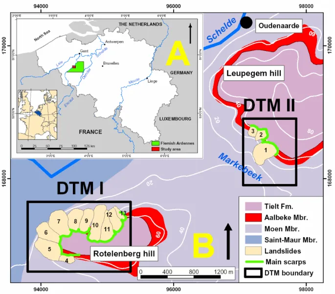
This study focuses on two hills of the Flemish Ardennes situated along the river Schelde close to the town of Oudenaarde (Fig. 1). These 60-m-high hills culminate between 75 and 85 meters. In the north, the Leupegem hill is affected by 3 landslides. To the south, 10 landslides developed on the slopes of the Rotelenberg hill.
These 13 landslides extend in subhorizontal (dip to the north < 1°) Eocene sediments composed of alternating clays and clayey sands on which a perched water table can develop. Within these formations, the Aalbeke Member consists of 10-m-thick homogeneous blue massive clays, and has been recognized as the layer most sensitive to landsliding (Fig. 1).
Fig. 1. (A) Location map of the Flemish Ardennes and the study area. (B) Location of the two hills of the study area with the lithological setting and the boundaries (scars) and the main scarps of the 13 landslides considered in the analysis. The quadrangles I and II locate the two DTMs used in the kinematic analysis.
3. DTMs construction
Precise DTMs of the 13 landslides have been obtained by digital stereophotogrammetry using aerial photographs at various image scales between 1:18,500 and 1:25,000 of three different periods. The photograph negatives were scanned with an LH Systems DSW 300 precision scanner with a pixel resolution of 12.5 µm that corresponds to a ground resolution of approximately 20 to 30 cm. The interior orientation was performed by using the parameters of the camera established by the geometric calibration. The final accuracy of the interior orientation is higher than 10 cm, so that the RMS error of this orientation will not act significantly upon the final accuracy of the stereomodels.
Waldhäusl, 1994; Mikhail et al., 2001). The absolute orientation of the block adjustment requires the use of ground control points. Moreover, it must be accurate enough to reflect the actual state of the ground surface. The block adjustment accuracy was evaluated using check points with known coordinates, but not used as control in the solution. About 25 ground control points and check points acquired by global positioning system (GPS) were used for the adjustment. The measurements were carried out by differential GPS in rapid static mode involving baselines of a few km length. The uncertainty on the baseline components (N, E, and Up) is of ~2-3 cm. Absolute positioning of the control and check points relies on the inclusion of five IGN points of known coordinates within the GPS network. The final uncertainty on the coordinates of the control and check points do not exceed 10 cm, thus remaining far below that of the block adjustment. We built firstly the stereomodel of the epoch 1996. The two other stereomodels were then constructed by including the orientation parameters of 1996. The global RMS errors obtained range between ~20 cm and 55 cm for the three stereomodels.
Since the automatic terrain extraction methods within SOCET SET were not able to provide sufficiently accurate DTM in many places, especially in the forested areas of the study area, the stereoscopic data capture of spot heights (ground points) and breaklines (scarps, roads, water bodies) on the landscape surface was performed by eye, by manually adjusting a floating mark until it touched the surface viewed in stereo. The spot heights were extracted approximately every 5 to 10 meters. These spot heights and breaklines (which depict abrupt changes in elevation and increase the accuracy of the DTMs) were interpolated with SURFER 8.0 by kriging for a DTM generation in the form of a 2 m × 2 m grid. The kriging parameters used to interpolate the DTMs were determined on the basis of variograms. The mean errors of the kriging interpolations are ~ 40 cm.
Combining the aerotriangulation and the kriging errors, an accuracy (RMSE) of approximately 50 cm, 55 cm and 65 cm was obtained respectively for the DTMs of 1996, 1973 and 1952 (Dewitte, 2006).
4. Landslide kinematics
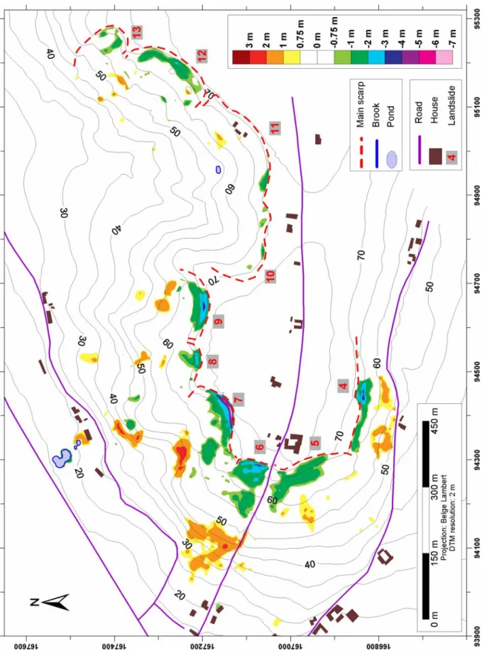
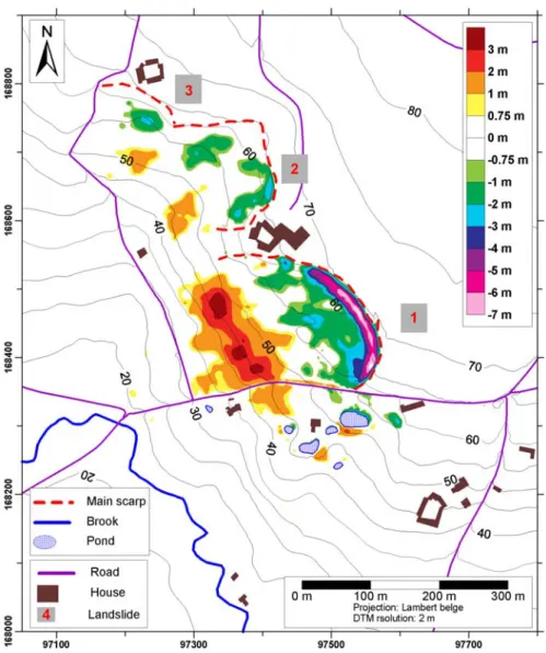
The obtained DTMs were subtracted from each other in order to determine the vertical displacement of each pixel during the considered time interval (Fig. 2 and Fig. 3). These maps are represented with a 68.3 % confidence interval (i.e. ± 0.75 cm) which corresponds to the combination of the RMSE of two DTMs (Mikhail et al., 2001). It means that only the vertical movements higher than 75 cm are considered as significant and therefore are represented on these maps.
At the head of the landslides, large apparent vertical motion values generally correspond to the height of the scarps actually retreating. There, the amount of scarp retreat may be fairly approximated by the width of the band of “collapsed” terrains. Globally, movements are observed in all the landslides and they generally correspond to a rotational pattern (Fig. 2 and Fig. 3). These movements were more intense in the Rotelenberg hill during the 1952-1973 period and more intense in the Leupegem hill during the 1973-1996 period (Dewitte, 2006).
Fig. 2. Elevation changes within the landslide of the Rotelenberg hill from 1952 to 1996. Only
Fig. 3. Elevation changes within the landslide of the Leupegem hill from 1952 to 1996. Only
the movements in excess of 1 ó uncertainty are represented.
5. Conclusions
This research has shown that from aerial photographs oriented by digital photogrammetric procedures we were able to produce accurate DTMs of some deep-seated landsides at different dates and then, by subtracting them from each other, to locate the landslide reactivated parts with an accuracy of 75 cm.
REFERENCES
Dewitte, O., 2006. Kinematics of landslides in the Oudenaarde area and prediction of their
reactivation: a probabilistic approach, Ph.D. Thesis. Liège: University of Liège.
Kraus, K. and Waldhäusl, P., 1994. Photogrammetry: fundamentals and standard processes, 1. Bonn: Dümmler Verlag.
Mikhail, E.M., Bethel, J.S. and McGlone, J.C., 2001. Introduction to modern photogrammetry. New York: Wiley.