HAL Id: tel-02083988
https://pastel.archives-ouvertes.fr/tel-02083988
Submitted on 29 Mar 2019
HAL is a multi-disciplinary open access
archive for the deposit and dissemination of sci-entific research documents, whether they are pub-lished or not. The documents may come from teaching and research institutions in France or abroad, or from public or private research centers.
L’archive ouverte pluridisciplinaire HAL, est destinée au dépôt et à la diffusion de documents scientifiques de niveau recherche, publiés ou non, émanant des établissements d’enseignement et de recherche français ou étrangers, des laboratoires publics ou privés.
Roberto Frau
To cite this version:
Roberto Frau. Utilisation des données historiques dans l’analyse régionale des aléas maritimes
ex-trêmes : la méthode FAB. Mécanique des fluides [physics.class-ph]. Université Paris-Est, 2018.
Résumé
La protection des zones littorales contre les agressions naturelles provenant de la mer, et no-tamment contre le risque de submersion marine, est essentielle pour sécuriser les installations côtières. La prévention de ce risque est assurée par des protections côtières qui sont conçues et régulièrement vérifiées grâce généralement à la définition du concept de niveau de retour d’un événement extrême particulier. Le niveau de retour lié à une période de retour assez grande (de 1000 ans ou plus) est estimé par des méthodes statistiques basées sur la Théorie des Valeurs Extrêmes (TVE). Ces approches statistiques sont appliquées à des séries temporelles d’une va-riable extrême observée et permettent de connaître la probabilité d’occurrence de telle vava-riable. Dans le passé, les niveaux de retour des aléas maritimes extrêmes étaient estimés le plus souvent à partir de méthodes statistiques appliquées à des séries d’observation locales. En général, les séries locales des niveaux marins sont observées sur une période limitée (pour les niveaux ma-rins environ 50 ans) et on cherche à trouver des bonnes estimations des extrêmes associées à des périodes de retour très grandes. Pour cette raison, de nombreuses méthodologies sont utili-sées pour augmenter la taille des échantillons des extrêmes et réduire les incertitudes sur les estimations. En génie côtier, une des approches actuellement assez utilisées est l’analyse régio-nale.
L’analyse régionale est indiquée par Weiss (2014) comme une manière très performante pour réduire les incertitudes sur les estimations des événements extrêmes. Le principe de cette mé-thodologie est de profiter de la grande disponibilité spatiale des données observées sur différents sites pour créer des régions homogènes. Cela permet d’estimer des lois statistiques sur des échantillons régionaux plus étendus regroupant tous les événements extrêmes qui ont frappé un ou plusieurs sites de la région.
De récents travaux sur la collecte et l’utilisation des événements du passé dans les analyses statistiques des extrêmes ont montré le rôle essentiel de ceux-ci sur les estimations. Lorsqu’on estime des événements extrêmes, les événements historiques, s’ils sont disponibles, doivent être considérés pour calculer des niveaux de retour fiables. Etant collectés grâce à différentes sources, les événements du passé sont des observations ponctuelles qui ne proviennent d’aucune série temporelle. Pour cette raison, dans la plupart des cas, aucune information est disponible sur les éventuels événements extrêmes qui sont survenues avant et après cette observation du
passé. Cela ainsi que le caractère particulier de chaque événement historique ne permet pas son utilisation dans une analyse régionale classique.
Une méthodologie statistique appelée FAB qui permet de réaliser une analyse régionale tenant en compte les données historiques est développée dans ce manuscrit. Elaborée pour des données POT (Peaks Over Threshold), cette méthode est basée sur une nouvelle définition d’une durée d’observation, appelée durée crédible, locale et régionale et elle est capable de tenir en compte dans l’analyse statistique les trois types les plus classiques de données historiques (données ponctuelles, données définies par un intervalle, données au dessus d’une borne inferieure). En plus, une approche pour déterminer un seuil d’échantillonnage optimal est définie dans cette étude.
La méthode FAB est assez polyvalente et permet d’estimer des niveaux de retour soit dans un cadre fréquentiste soit dans un cadre bayésien. Une application de cette méthodologie est réali-sée pour une base de données enregistrées des surcotes de pleine mer (données systématiques) et 14 surcotes de pleine mer historiques collectées pour différents sites positionnés le long des côtes françaises, anglaises, belges et espagnoles de l’Atlantique, de la Manche et de la mer du Nord.
Enfin, ce manuscrit examine la problématique de la découverte et de la validation des données qui représentent les évènements du passé.
Using historical data in the
Re-gional Analysis of extreme coastal
Abstract
The protection of coastal areas against the risk of flooding is necessary to safeguard all types of waterside structures and, in particular, nuclear power plants. The prevention of flooding is guar-anteed by coastal protection commonly built and verified thanks to the definition of the return level’s concept of a particular extreme event. Return levels linked to very high return periods (up to 1000 years) are estimated through statistical methods based on the Extreme Value Theory (EVT). These statistical approaches are applied to time series of a particular extreme variable observed and enables the computation of its occurrence probability.
In the past, return levels of extreme coastal events were frequently estimated by applying sta-tistical methods to time series of local observations. Local series of sea levels are typically observed in too short a period (for sea levels about 50 years) in order to compute reliable esti-mations linked to high return periods. For this reason, several approaches are used to enlarge the size of the extreme data samples and to reduce uncertainties of their estimations. Currently, one of the most widely used methods in coastal engineering is the Regional Analysis.
Regional Analysis is denoted by Weiss (2014) as a valid means to reduce uncertainties in the estimations of extreme events. The main idea of this method is to take advantage of the wide spatial availability of observed data in different locations in order to form homogeneous regions. This enables the estimation of statistical distributions of enlarged regional data samples by clus-tering all extreme events occurred in one or more sites of the region.
Recent investigations have highlighted the importance of using past events when estimating extreme events. When historical data are available, they cannot be neglected in order to compute reliable estimations of extreme events. Historical data are collected from different sources and they are identified as data that do not come from time series. In fact, in most cases, no infor-mation about other extreme events occurring before and after a historical observation is availa-ble. This, and the particular nature of each historical data, do not permit their use in a Regional Analysis.
A statistical methodology that enables the use of historical data in a regional context is needed in order to estimate reliable return levels and to reduce their associated uncertainties.
In this manuscript, a statistical method called FAB is developed enabling the performance of a Regional Analysis using historical data. This method is formulated for POT (Peaks Over
Threshold) data. It is based on the new definition of duration of local and regional observation period (denominated credible duration) and it is able to take into account all the three typical kinds of historical data (exact point, range and lower limit value). In addition, an approach to identify an optimal sampling threshold is defined in this study. This allows to get better estima-tions through using the optimal extreme data sample in the FAB method.
FAB method is a flexible approach that enables the estimation of return levels both in fre-quentist and Bayesian contexts. An application of this method is carried out for a database of recorded skew surges (systematic data) and for 14 historical skew surges recovered from dif-ferent sites located on French, British, Belgian and Spanish coasts of the Atlantic Ocean, the English Channel and the North Sea. Frequentist and Bayesian estimations of skew surges are computed for each homogeneous region and for every site.
Finally, this manuscript explores the issues surrounding the finding and validation of historical data.
Contents
1 INTRODUCTION ... 1
1.1
Thesis context ... 3
1.1.1
Industrial framework ... 3
1.1.2
Scientific framework ... 4
1.2 State of art ... 6
1.2.1
Regional Analysis ... 6
1.2.2
Historical data in extreme value analyses ... 7
1.2.3
Historical data in regional analyses ... 9
1.3
Main objectives ... 9
2 HISTORICAL DATA ... 13
2.1 Historical data ... 14
2.2
Collection and validation approach ... 17
2.2.1
Historical data collection ... 17
2.2.2
Historical data validation ... 20
2.2.3
Numerical models and their role for historical events ... 21
3 FAB METHOD ... 27
3.1 Introduction ... 28
3.1.1
The RFA approach (Weiss, 2014) ... 29
3.2
FAB Method ... 33
3.2.1
Addition of historical data ... 36
3.2.2
Local and Regional Credible duration ... 38
3.2.3
The use of different types of historical data ... 40
3.2.4
Penalised maximum likelihood ... 41
3.2.5
Likelihood formulation with historical data ... 42
3.2.6
Choice of statistical threshold ... 48
3.2.7
Frequentist return levels ... 57
3.2.8
Bayesian return levels ... 58
4 FAB APPLICATION ... 61
4.1 Introduction ... 62
4.2 Skew surge database ... 63
4.2.1
Definition of skew surge ... 63
4.2.2
Systematic skew surge database ... 65
4.2.3
Historical skew surges ... 68
4.3
Physical homogeneous regions ... 73
4.4
Computation of optimal sampling threshold ... 84
Contents
xi
4.6
Frequentist estimations of return levels ... 90
4.7 Estimations without historical data ... 94
4.8
Bayesian estimations of return levels ... 100
4.9
Frequentist and Bayesian estimations ... 106
5 CONCLUSIONS ... 109
5.1
Conclusions ... 110
5.2 Future works and perspectives ... 113
Annexe A: HISTORICAL DATA IN REGIONAL ANALYSIS ... 115
1.1 Historical data in regional analysis (2018) ... 116
1.2 Regional analysis and historical data ... 130
Annexe B: THE BAYESIAN INFERENCE ... 131
2.1 The Bayesian inference ... 132
2.1.1
Basic elements for Bayesian estimations ... 133
Annexe C: REGIONAL BAYESIAN ANALYSIS ... 137
3.1 Regional Bayesian analysis ... 138
Annexe D: HISTORICAL DATA ... 139
4.1 Collection of historical skew surges ... 140
4.2
Simulations of extreme skew surges ... 141
Annexe E: SUMMARY TABLE OF RESULTS ... 149
5.1
Summary table of the FAB application ... 150
6.1
Storm frequency on the longest time series ... 154
List of Figures
Fig. 1 - The Blayais Nuclear Power Plant located in the Gironde estuary near Blaye (France) ... 3
Fig. 2 – The flood occurred during the day of 11th September 1903 at Le Havre described by three different newspapers: Météo Paris, Le Petit Journal and Ouest-Éclair ... 18
Fig. 3 - Scheme used to reconstruct 11 historical skew surges ... 19
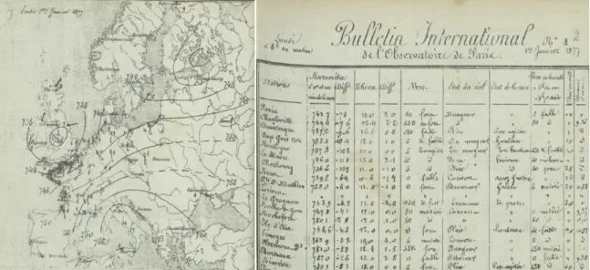
Fig. 4 – Daily weather report on the left and Pressure chart on the right for the 1st January 1877 (source Météo France) ... 23
Fig. 5 – Synoptic charts generated by reanalysis 20CRV2C of the pressure on sea surface (hPa) every 6 hours between the 31st December 1876 and the 1st January 1877 ... 25
Fig. 6 - Synoptic charts generated by reanalysis 20CRV2C of wind direction and wind speed (m/s) every 6 hours between the 31st December 1876 and the 1st January 1877 ... 26
Fig. 7 – Scheme for λ computation on systematic time series ... 37
Fig. 8 – Definition of skew surge. Source: SurgeWatch Glossary (University Southampton) ... 64
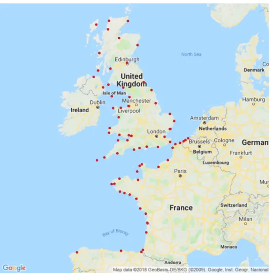
Fig. 9 - Location of 74 tide gauges considered in this study. Source of the map: Google Maps. .. 66
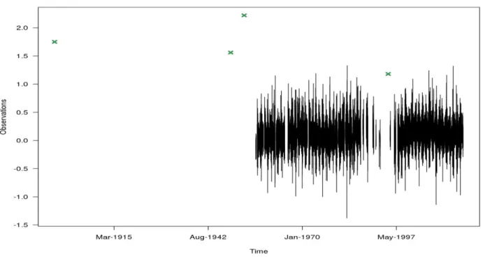
Fig. 10 - The longest time series of skew surge database (measurements recorded by Brest tidal
gauge) ... 67
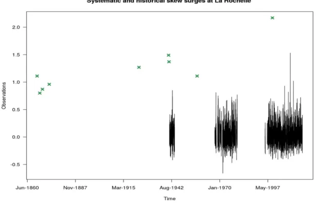
Fig. 11 – Systematic skew surge recorded by the tide gauge at La Rochelle (in black)and historical skew surges (in green) recovered for La Rochelle ... 69
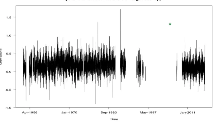
Fig. 12 - Systematic skew surge recorded by the tide gauge at Dieppe (in black) and historical skew surges (in green) recovered for Dieppe ... 70
Fig. 13 - Systematic skew surge recorded by the tide gauge at Dunkirk (in black) and historical skew surges (in green) recovered for Dunkirk ... 71
Fig. 14 – Number of operating tide gauges per year ... 74
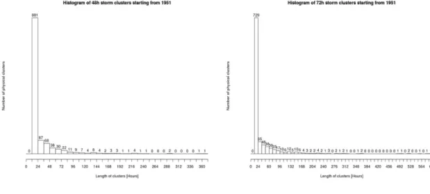
Fig. 15 – Histogram of the number of storm clusters created by a Δ=25 hours and a η=16 in function of their storm duration (in hours) for storms happened after the year 1950 ... 77
Fig. 16 - Histograms of the number of storm clusters created by a Δ=48 hours (on the left) or a Δ=72 hours (on the right) and a η=16 in function of their storm duration (in hours) for storms
happened after the year 1950 ... 78
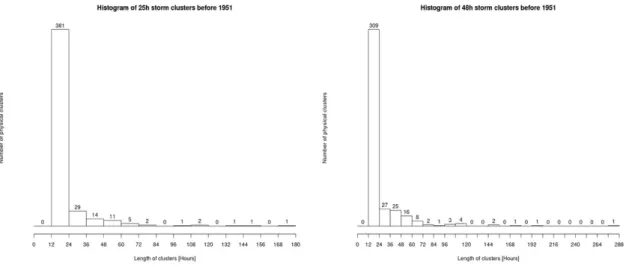
Fig. 17 - Histogram of the number of storm clusters created by a Δ=72 hours and a η=16 in function of their storm duration (in hours) for storms happened before the year 1951 ... 78
Fig. 18 - Histograms of the number of storm clusters created by a Δ=25 hours (on the left) or a Δ=48 hours (on the right) and a η=16 in function of their storm duration (in hours) for storms happened before the year 1951 ... 79
Fig. 19 – Physical regions formed for different values of the spatial parameter η (10,11,12,13,14,15,17,18) around the value parameter of η=16 selected and using the selected temporal parameter Δ of 25 hours. Source of the map: Google Maps ... 80
Fig. 20 – The graph of the Mojena’s stopping rule (on the left) and the cluster dendrogram (on the right) ... 81
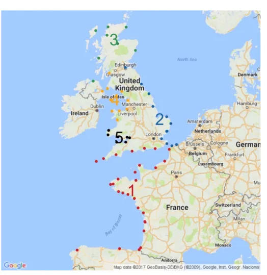
Fig. 21 – The 4 physical homogeneous regions founded by the typical storm footprints for events happened after the year 1950. Source of the map: Google Maps ... 82
Fig. 22 – The five physical and statistical regions founded in the PhD thesis of Weiss 2014 ... 83
Fig. 23 – Sensitivity analysis of secondary parameters used for the Region 1 ... 85
Fig. 24 – Sensitivity analysis of secondary parameters used for the Region 2 ... 86
Fig. 25 – Sensitivity analysis of regional Bayesian scale parameter for Region 1 and Region 2 ... 87
Fig. 26 – Sensitivity analysis of regional Bayesian shape parameter for Region 1 and Region 2 . 88
Fig. 27 – Physical and statistical regions for lambda=0.84 and lambda=1.79. Source of map: Google Maps ... 89
Fig. 28 – Regional return level plot for the Region 1 ... 91
Fig. 29 – Regional return level plot for the Region 2 ... 92
Fig. 30 – Local return levels plots for the sites of La Rochelle (on the left) and Calais (on the right) ... 94
xv
Fig. 32 – Regional return level plot for the Region 2 without the use of historical data ... 98Fig. 33 – Local return level plots for the sites of La Rochelle (on the left) and Calais (on the right)
without the use of historical data ... 99
Fig. 34 – Progressive PSFR values of tests of Gelman and Rubin for Region 1 and Region 2 ... 101
Fig. 35 – Values of regional GPD scale and shape parameters of each iteration for the 3 chains of Region 1 ... 101
Fig. 36 - Values of regional GPD scale and shape parameters of each iteration for the 3 chains of Region 2 ... 102
Fig. 37 – Regional return level plot of Bayesian estimations for Region 1 ... 103
Fig. 38 - Regional return level plot of Bayesian estimations for Region 2 ... 104
Fig. 39 - Return level plots of Bayesian estimations for La Rochelle (site belonging to Region 1) and Calais (site belonging to Region 2) ... 105
Fig. 40 – Regional return level plot of frequentist estimations for Region1 and Region 2 without seasonality ... 107
Fig. 41 - Return level plots of frequentist estimations for La Rochelle (site belonging to Region 1) and Calais (site belonging to Region 2) without seasonality ... 108 Fig. 42 - Variability of storm frequency for different thresholds corresponding to quantile of 0.997, 0.998, 0.9985 and 0.999 at Brest tide gauge ... 155 Fig. 43 - Variability of storm frequency for different thresholds corresponding to quantile of 0.997, 0.998, 0.9985 and 0.999 at Newlyn tide gauge ... 155
List of Tables
Tab. 1 – Historical skew surges recovered at the site of La Rochelle ... 69
Tab. 2 - Historical skew surges recovered at the site of Dieppe and Dunkirk ... 70
Tab. 3 – Regional parameters computed by the FAB method applied to the Region 1 ... 90
Tab. 4 - Regional return levels computed by the FAB method applied to the Region 1 ... 91
Tab. 5 - Regional parameters computed by the FAB method applied to the Region 2 ... 92
Tab. 6 - Regional return levels computed by the FAB method applied to the Region 2 ... 92
Tab. 7 - Results for the sites of La Rochelle (Region 1) and Calais (Region 2) ... 93
Tab. 8 - Regional parameters computed by the FAB method applied to the Region 1 without historical data ... 95
Tab. 9 - Regional parameters computed by the FAB method applied to the Region 2 without historical data ... 95
Tab. 10 - Regional return levels computed by the FAB method applied to the Region 1 without historical data ... 96
Tab. 11 - Regional return levels computed by the FAB method applied to the Region 2 without historical data ... 96
Tab. 12 - Results for the sites of La Rochelle (Region 1) and Calais (Region 2) without historical data ... 99
Tab. 13 - Useful parameters and results computed by the Bayesian analysis on the Region 1 .... 102
Tab. 14 - Useful parameters and results computed by the Bayesian analysis on the Region 2 .... 103
Tab. 15 – Bayesian estimations for the sites of La Rochelle (Region 1) and Calais (Region 2) .. 105
Tab. 16 - Useful parameters and results computed by the Bayesian analysis on the Region 1 without seasonality ... 106
Tab. 17 - Frequentist estimations for the sites of La Rochelle (Region 1) and Calais (Region 2) without seasonality ... 107 Tab. 18 - Summary table of the FAB application's results ... 150
Chapter 1
INTRODUCTION
La connaissance de la probabilité d’occurrence des événements maritimes ex-trêmes est indispensable pour concevoir et préserver les installations côtières et, notamment, les parcs nucléaires en bord de mer contre le risque inondation. Ces probabilités peuvent être estimées à partir des éléments de base de la Théo-rie des Valeurs Extrêmes et, en particulier, du concept de niveau de retour : un événement associé à une période de retour de T ans correspond à un événement qui a une probabilité d’être dépassé une fois tous les T ans en moyenne.
Dans le passé, les niveaux de retour des aléas maritimes extrêmes étaient éva-lués à travers des analyses statistiques locales. Le principe de ces analyses est d’utiliser la TVE sur des événements extrêmes observés sur un unique site. Dans la plupart de cas, les résultats des applications locales montrent d’importantes incertitudes liées aux estimations des événements extrêmes.
Pour ces raisons, différentes approches alternatives comme l’analyse régionale et l’utilisation des données historiques sont actuellement utilisées en génie côtier pour améliorer les estimations des événements extrêmes.
L’analyse régionale est une méthodologie statistique qui permet d’identifier tous les événements extrêmes qui se sont produits dans une région et de les utiliser dans l’analyse statistique. Cette approche conduit souvent à des estimations plus fiables à travers l’exploitation d’un plus grand nombre des données extrêmes.
Différents types d’approches régionales ont été proposés depuis le 1960 pour les applications environnementales. En ingénierie maritime, l’approche la plus récente et complète est l’Analyse Fréquentielle Régionale proposée par Weiss (2014).
L’apport des données historiques dans les analyses statistiques locales est une autre approche utilisée qui permet d’obtenir des estimations liées à des incerti-tudes réduites. La plupart de ces analyses sont permises grâce à l’utilisation du concept de seuil de perception (Gaume et al., 2010 ; Payrastre et al., 2011 ; Bulteau et al., 2015 ; Hamdi et al., 2015). Cette notion permet d’évaluer la pé-riode d’observation historique en supposant l’exhaustivité des données histo-riques au-dessus de ce seuil de perception.
La combinaison de ces deux approches pourrait contribuer à améliorer encore plus les estimations des événements extrêmes. Cependant, l’utilisation des don-nées historiques dans un contexte régional est un sujet compliqué à traiter en génie maritime. En effet, la connaissance de la période d’observation est indis-pensable pour réaliser une analyse statistique. Les aléas maritimes historiques manquent souvent d’informations supplémentaires concernant leurs périodes d’observations. Pour cette raison, aucune hypothèse d’exhaustivité ne peut être vérifiée et donc le concept de seuil de perception ne peut pas être utilisé. La définition d’un nouvel élément qui permet d’estimer de manière crédible la du-rée d’observation des données historiques est requise.
Une méthodologie régionale (appelé FAB) basée sur le nouveau concept de du-rée crédible est développé dans ce manuscrit. Elle permet de considérer tous les types des données historiques les plus communes dans l’analyse régionale des événements maritimes extrêmes. Enfin, des estimations fréquentistes et bayésiennes peuvent être évaluées avec l’application de cette méthode.
1.1 Thesis context
3
1.1 Thesis context
1.1.1 Industrial framework
The protection of coastal infrastructures and, in particular, nuclear power plants from flooding is an overriding priority for EDF. The characterisation of extreme sea weather conditions allows the design of suitable protections in order to guarantee the safety of nuclear fleets against flood risk.
Fig. 1 - The Blayais Nuclear Power Plant located in the Gironde estuary near Blaye (France)
EDF manages the flood risk of its nuclear fleets originated by external hazards in accordance with the French regulatory framework (ASN, 2013). In particular, different situations of flood risk are defined, all of which must be used to design protections in order to preserve the safety of nuclear fleets. Flood of a platform on which a nuclear power plant is installed can provoke water infiltration in internal rooms containing important elements for the nuclear safety. Floods can also indirectly induce negative effects such as the accumulation of different types of debris in water intake of pump stations that can cause problems on cooling circuits.
The flood risk linked to high sea levels requires the computation of a high sea level of reference. This high sea level of reference enables the design and the verification of protections for nuclear power plants located on the coastline.
The French regulatory framework (ASN, 2013) provides guidelines for the evaluation of the high sea level of reference of each particular nuclear power station. The high sea level of refer-ence must be calculated as the sum of the maximum astronomical tide, the upper bound of 70% confidence interval of the skew surge associated to a return period of 1000 years and the mean sea level trend. If the maximum astronomical tide is evaluated by results obtained from local or regional measurement stations, extreme skew surges are evaluated by statistical methods. The estimation of skew surges associated to a return period of 1000 years can be performed both by local analysis and by regional analysis applied to time series of reliable observations. Moreover, the ASN (2013) clarifies that historical skew surges have to be considered in statis-tical estimations. Local analysis has several limitations as, for instance, a proper consideration of outliers (very rare events) in the extreme skew surge estimations. For this reason, the use of a regional analysis is allowed by the ASN (2013) only if this statistical methodology is able to show the suitability of the observed outliers.
The processing of a proper regional analysis methodology that allows the exploitation of all spatial data and historical skew surges available is needed in order to be able to estimate extreme skew surges that properly take into account the outliers.
1.1.2 Scientific framework
For the design of defence’s coastal infrastructures, the estimation of the occurrence probability of extreme sea water levels is required. Probabilities of extreme events can be computed fol-lowing the basic elements of Extreme Value Theory (EVT).
EVT is a specific branch of statistics that was introduced at the beginning of the 20th century by
Frechet (1927) and Fisher and Tippett (1928). This is later developed by the studies of Gnedenko (1943), Weibull (1951), Gumbel (1958), Picklands (1975), Coles (2001) and Beirlant et al (2004). EVT provides a set of probability distributions for extremes that enables the esti-mation of the occurrence probability of extreme events through the use of the concept of return period. An event associated to a return period of T years corresponds to the event that has a probability 1/T to be exceeded every year over a period of T years or, in other words, it is the event that is exceeded on average once in T years.
Statistical approaches associated to the basic elements of EVT are used in order to estimate sea levels linked to high return periods. In particular, the two most common statistical approaches
1.1 Thesis context
5
for practical extreme value analysis rely respectively on Block Maxima (or Annual Maxima) data and on Peaks Over Threshold data (Coles, 2001). BM data typically converges in a Gen-eralised Extreme Value distribution while POT data classically converges in a GenGen-eralised Pa-reto Distribution.Moreover, direct or indirect estimation of extreme sea levels can be computed depending on which variable is analysed. Direct estimations are calculated by statistical analyses applied di-rectly on sea level without considering its deterministic and stochastic parts. In fact, sea level can be schematically represented as the overlap of the predicted astronomical tide and the surge (respectively its deterministic and its stochastic part, Fig. 8). Indirect approaches consider sep-arately these two components of sea level assuming extreme value analyses of surges as more convenient. Astronomical tides and surges are successively recombined in order to estimate extreme sea levels. In particular, convolution methods might be used to define the probability distribution of sea levels in indirect approaches (Kergadallan, 2013). Indirect approaches are preferred for sites in which tidal range between high and low tides are significant (Weiss, 2014). Regardless of the maritime variable considered, efficient statistical methods and a sufficient number of data are required in order to get reliable estimations of extremes. In the past, data originated from a single tide gauge was used to fit statistical distributions for a particular site and extreme estimations produced were usually full of uncertainties. This may be explained by the fact that the duration of recordings could not be too long to estimate reliable extreme varia-bles. This is the case of sea levels where usually recordings last from 30 to 50 years. For this reason, estimations of extreme sea levels (associated to a return period of up to 1000 years) achieved by local analysis are in the most part not suitable to be used for engineering applica-tions.
Nowadays, innovative statistical methods are used to enlarge the sample of extreme data. Re-gional analysis and the use of historical data are two relevant approaches that can applied to improve extreme estimations.
Regional analysis is able to exploit the wide availability of data in different locations. Creating larger samples of regional data typically results in reduced uncertainties of the extreme estima-tions.
Historical data are generally used to extend local samples considering very strong events oc-curred in the past. In this way, statistical analyses are applied to a bigger sample of extreme data.
The combination of these two methodologies and therefore a regional analysis with historical data allows the extension of extreme data samples, and in effect exploiting all the spatial and historical information available. The creation of a regional sample that includes historical data further improves the estimations of extreme events.
1.2 State of art
In this section, methods developed and currently used for environmental applications by differ-ent authors on the use of historical data and on the regional analysis are presdiffer-ented.
1.2.1 Regional Analysis
Regional Analysis is a statistical methodology that is able to exploit all the data available in a region to reduce uncertainties on the extreme estimations. The main idea of Regional Analysis is to pool similar sites into a homogeneous region, to create an extended regional data sample and, in this way, to estimate a regional distribution.
Regional methods are widely used to improve statistical estimations of extreme events linked to environmental applications since 1960. Dalrymple (1960), Stedinger (1983), Cunnane (1988), Madsen and Rosbjerg (1997), Ouarda et al. (1999), De Michele and Rosso (2001), Jav-elle et al. (2002), Kjeldsen et al. (2002), Merz and Bloschl (2003), Viglione et al. (2007) and Saf (2009) use Regional Analysis to compute extreme river discharges, Schaefer (1990), Hosk-ing and Wallis (1997), Alila (1999) and Borga et al. (2005) to estimate extreme rainfalls and Goel et al. (2004), Sotillo et al. (2006) and Escalante-Sandoval (2008) to calculate extreme winds.
Regional Analysis for several maritime variables is more recent. In order to improve estimations of extreme significant wave heights, Goda et al. (2010) and Goda (2011) use the regional method for 11 sites located in the Japanese east coasts and, in the same way, Val Gelder et al., 2000 applied a regional methodology to 9 locations of the North Sea. In addition, Regional Analysis is applied also to improve extreme estimations of the tsunamis run-up for 114 sites of
1.2 State of art
7
the Pacific Ocean by Hosking (2012) and of the sea levels for 13 sites located in North Sea by Val Gelder and Neykov, 1998.Moreover, several applications for skew surges has been achieved mainly in last years. Ber-nardara et al. (2011) and Bardet et al. (2011) estimate extreme skew surges by a regional anal-ysis applied to respectively 18 and 21 sites located in French coasts of the Atlantic Ocean and the English Channel.
Last recent regional methodology is proposed and used for skew surges by Weiss et al. (2013) and Weiss (2014). This Regional Frequency Analysis approach is based on the index-flood method proposed by Dalrymple (1960) permitting to estimate a regional probability distribution that is common to all extreme observations up to a local index representing the local specificities of a site. Extreme events collected from different sites of a same homogeneous region follow the same regional probability (Hosking and Wallis, 1997; Weiss, 2014). Regional probability distribution must be computed for independent regional observations to estimate correctly ex-treme events. For this reason, Weiss (2014) proposes a model to cluster different storms and to treat statistically independent regional data in order to avoid a likely redondance of regional events.
Results of the RFA application shown as the regional analysis is able to reduce the uncertainties on the estimations of return levels. In particular, results obtained by Weiss (2014) shows that return levels computed by a classical local analysis contains 55% more of uncertainties on av-erage in each site for return levels linked to 100 years of return period compared to the same local return levels computed by regional analysis. In addition, local outliers have typically a less extraordinary and unique nature in the regional analysis.
Nevertheless, the RFA approach can be applied only for continuous time series of gauged coastal events. Further details of this methodology are set out in Chapter 3.
1.2.2 Historical data in extreme value analyses
The use of historical data in the estimation of extreme events represents another method to improve the reliability of return levels. Historical data enables typically the extension of ex-treme data samples in which statistical analyses are applied. Moreover, they permit the consid-eration of all the extraordinary events that are happened in the past.
The extension of an extreme data sample using historical data is possible only after their col-lection and their validation. The colcol-lection and the validation of historical data is required before any statistical analysis that allows the use of them. In addition, the knowledge of the period in which historical data are the biggest ones observed is important for the statistical analysis of the extreme events (Leese, 1973; Prosdocimi, 2017). For these reasons, the collection and recon-struction of exceptional historical coastal events (Parent et al., 2007; Pouvreau, 2008; Garnier and Surville, 2010; Brehil, 2014; Brehil et al.,2014; Peret and Sauzeau, 2014; Giloy et al., 2017) and the reconstruction of local time series during the past period have been performed for sites located in the French Atlantic coasts (Ferret, 2016).
When historical data are collected and validated, they can be used to improve the estimations of extreme events. In the past, historical data have been used to get better estimations of extreme events by Benson (1950), Condie and Lee (1982), Cohn (1984), Hosking and Wallis (1986a), Hosking and Wallis (1986b), Stedinger and Cohn (1986), Stedinger and Baker (1987), Ouarda et al. (1998) and Benito et al. (2004).
Miquel (1981) and Lang et al. (1997) modelled statistically systematic POT data above a thresh-old and historical POT data above a perception threshthresh-old (Renewal Method). This formulation enables the use of different types of historical data in a local statistical analysis and it can be used only after the verification of the hypothesis of exhaustiveness of the historical data above the perception threshold. For coastal events, no local or regional information on the historical period is frequently available.
Some statistical studies enabling the use of historical data in local statistical analysis have been developed in hydrology. These studies (Gaume et al., 2010; Payrastre al., 2011; Payrastre et al., 2013) are based on the concept of the perception threshold and they are performed to estimate Bayesian return levels linked to high return period.
In coastal engineering, the use of historical data was being less developed in the past due to the weak availability of historical data. Currently, scientific studies that use coastal historical data are increasingly performed to improve estimations of extreme coastal events.
In particular, Baart et al. (2011) estimate return levels of storm surges using three reconstructed historical surges occurred in Dutch coasts in the 18th century. Hamdi et al. (2015) propose two
different approaches to consider different types of historical information in statistical analysis. The first approach is block maxima method (BMH) and it can be performed for the three typical types of historical data. The second approach (the peaks-over-threshold method POTH) allow the use of two different types of historical data: historical maxima (HMax) data and
over-a-1.3 Main objectives
9
threshold supplementary (OTS) data. These methodologies based on the perception threshold concept are applied for historical skew surges recovered in the site of La Rochelle (France). Bulteau et al. (2015) proposes the HIBEVA method to treat historical data in the Bayesian anal-ysis of extreme sea levels. This method is elaborate for POT data. Using 8 historical sea levels, they show by the use of the historical threshold the value of the historical events in a statistical analysis of extreme events.All of these studies applied to coastal variables are developed for local analysis.
1.2.3 Historical data in regional analyses
More complex and difficult is to find scientific studies that use historical data to get better re-gional return levels. The combination of these two methodologies has been recently used in hydrology by Nguyen et al. (2014) and Sabourin and Renard (2015). In particular, a multivariate peaks-over-threshold model is proposed by this last study. This model is applied to four French catchments in which historical data are available. Nguyen et al. (2014) propose a regional method that allows the use of historical data. This method is based on the regional method proposed by Hosking and Wallis (1997) and on the Bayesian approach formulated by Gaume et al. (2010) to introduce historical data in a local analysis. The application of this method pro-vides regional Bayesian estimations adjusted with its credibility intervals. This method is ap-plied for BM data obtained to two French catchments.
In coastal engineering, the combination of regional analysis and historical data is actually un-explored.
1.3 Main objectives
A scientific challenge currently exists to define a new methodology that combines two different approaches in the statistical estimations of extreme coastal events: regional analysis and the use of historical data. This thesis focusses on the development of this new methodology as well as its application on a skew surge database.
Many scientific studies have highlighted the importance of using historical data in the estima-tions of extreme coastal events. Exceptional events of the past have to be considered in statisti-cal analyses of extreme coastal events in order to get reliable estimations. The addition of these data in local statistical analysis allows the estimations of extreme events associated to reduced uncertainties. In particular, the majority of these studies introduce historical data by the use of the concept of “perception threshold”. This concept is based on the exhaustiveness hypothesis of the observation period of historical events. Proving this hypothesis is currently challenging for the majority of coastal events of the past.
On the other hand, regional approaches permit the definition of larger extreme data samples considering all the extreme events impacting sites within a region. This allows the estimation of regional and local return levels associated to reduced uncertainties compared with return levels computed through local analyses. Many regional methodologies had been proposed in several scientific studies, but the RFA approach (Weiss, 2014) can be considered as one of the most complete and flexible regional methodologies for the estimations of extreme coastal events.
However, this approach can only be carried out with a database composed of systematic events. In particular, local continuous time series enables the computation of the period of observation of the regional events in the RFA approach. This effective regional duration is an essential element to estimate regional and local extreme events. On the contrary, historical data repre-sents typically isolated events of past periods or periods without systematic measurements and no further observations are locally available for these periods. In addition, a historical event is not always described by an exact data value. Different types of historical data are often available and the RFA approach enables the use of exact data values.
The RFA method is developed for POT data. For this reason, the definition of the sampling threshold is important to achieve the best performance of the statistical method. No approaches for the identification of the local sampling thresholds are proposed in the RFA method. Another limit of the RFA approach is the impossibility to estimate return levels in a statistical Bayesian framework. In fact, the RFA approach was only developed to obtain frequentist estimations of extreme events. For these reasons, a new methodology, called FAB method, that preserves all the basic elements of the RFA approach is proposed in this manuscript.
The FAB method overcomes all of these issues caused by the addition of historical data in a regional analysis. This method is based on the new concept of “credible duration” that allows the estimation of the period of observation of the regional extreme data sample.
1.3 Main objectives
11
The FAB method permits the use of all most common types of historical data through the for-mulation of a new regional likelihood. Moreover, a weighting approach based on the definition of primary and secondary parameters is proposed to identify optimal local sampling thresholds for regional extreme data samples composed by POT data. Finally, frequentist or Bayesian es-timations can be indifferently computed through the FAB method. The option to get frequentist or Bayesian estimations of regional and local return levels is user defined. This method is de-tailed in Chapter 3.An application of the FAB method to a skew surge database composed by systematic and his-torical data is performed in Chapter 4. Frequentist and Bayesian return levels are estimated and appropriately compared.
Nevertheless, the discovery of valid historical data is a complicated process. Chapter 2 of this manuscript discusses in detail the difficulties faced during the collection and the validation of historical data, and an example procedure is proposed.
Chapter 2
HISTORICAL DATA
Ce chapitre vise à définir la donnée historique, sa nature et les problématiques associées à sa collection et validation.
Dans ce manuscrit, les données historiques sont des données ponctuelles qui représentent des évènements remarquables survenus pendant des périodes dans lesquelles les instruments de mesure n’ont pas enregistré la variable considérée. Les trois types les plus communs de données historiques seront considérés dans cette étude : la donnée exacte, un intervalle de valeurs et une borne inférieure dépassée par la valeur historique lors de l’événement.
La connaissance d’une ou plusieurs événements historiques est un sujet difficile à traiter. En effet, les données historiques sont liées à différentes types d’infor-mations et de sources qui ne sont pas le plus souvent facilement interprétables et accessibles. Par conséquent, la collecte des données historiques est une pro-cédure compliquée. Toute l’information historique repérée doit être exploitée et, dans la mesure du possible, convertie en données historiques que pourraient être ensuite utilisée pour des applications statistiques d’estimation des événements extrêmes. Pour ces raisons, une approche de collecte et de validation des don-nées historiques suivie d’un exemple d’application est présentée dans ce cha-pitre. La collecte doit être démarrée à partir des bases des données historiques déjà existantes et étendue à des sources accessibles. Ensuite, une validation de toutes les données collectées doit être réalisée grâce à l’apport essentiel d’un historien compétant sur la période examinée.
2.1 Historical data
Historical data are typically quantitative or qualitative isolated data values representing an ex-ceptional event of the past. In this manuscript, historical data are defined as all quantitative isolated data values representing an extraordinary event which has occurred in a period in which the considered variable was not recorded by a measuring device. For this reason, historical data represent not only events of the past but also exceptional events in which, for whatever reason, the measuring device was not working.
The discovery of historical coastal events that can potentially provoke coastal flooding is a major challenge for an engineer dealing with estimations of extreme coastal events. Finding quantitative data values of historical events is a complex procedure. Information of a particular past event can be used to detect or reconstruct a quantitative data associated to that event. After a wide investigation of different sources, this is also possible by means of a good knowledge of the period of the event that only a qualified historian may have. An approach to collect and validate historical data is proposed in the following chapter.
Over the last twenty years, there have been a number of extraordinary storms such as Xynthia (February 2010) and Lothar and Martin (December 1999) storms, which impacted the European Atlantic coasts. These storms caused several disasters and loss of human life. These have been sometimes defined in the media as exceptional events that have never previously occurred on French coasts until now, however this is incorrect. A wide investigation of all the historical storms which impacted a particular site is required to define the rarity of an extreme event. In particular, Garnier and Surville (2010) identify several catastrophic flood events on the French Atlantic coasts during the last 500 years with a similar vulnerability to the Xynthia storm. For this reason, also if a recent exceptional storm can be perceived by people as the strongest event ever happened in a particular location, it may have previously occurred because history often repeats itself.
Furthermore, Bulteau et al. (2015) conclude that, considering historical traces in La Rochelle, the Xynthia storm is linked to a shorter return period. For this reason, considering all the traces of the past in the statistical analysis of extreme events could help to reduce the impact of natural calamities along the coasts.
2.1 Historical data
15
Several studies on past coastal floods impacting French coasts (Peret, 2004; Lambert and Garcin, 2013; Lang and Coeur, 2014; Peret and Sauzeau, 2014) show the difficulties faced re-searching useful information to retrace the history.Any type of information is useful to retrace the past and to collect, reconstruct or validate a historical data. For example, a painting, a newspaper of the time, a preserved manuscript, a document from municipal archives, an ecclesiastical text, some private letters sent to ask for help from friends and family, a water mark left in an ancient church or building are only a few sources containing useful information of the past which can be used to retrace a historical event. In addition, the vulnerability evaluation of the society of the period is required in order to un-derstand the relevance of a particular past event. This can be used to reply to the ever more frequently asked question regarding the occurrence of a remarkable flood.
Although finding the occurrence of an exceptional past event is challenging, the quantification of a historical event can be considered more complex. In fact, only a small portion of the iden-tified historical events may be expressed with some quantitative data, for instance, the case of water marks or overflows of sea levels in a coastal town. In these and other cases, many attempts have to be performed to retrace and rebuild the numerical value of the considered variable that represents the historical event.
Numerical values of historical events, more simply denominated historical data, can be used in the statistical analysis for extreme events. The use of historical data in the statistical analysis improves significantly the estimations of extreme coastal events (Bulteau et al., 2015; Hamdi et al., 2015). In particular, Hamdi et al. (2015) show as the use of historical data are considered at La Rochelle decreases the uncertainties linked to the estimations of extreme skew surges. For this reason, the use of past events in the extremes’ statistical analysis is required to get estima-tions of extreme events as reliable as possible.
Historical data can be regrouped in three major data types depending on the type of historical information found:
• Type I or exact data; • Type II or data range;
Type I is a data point, which can be considered as the most precise type of historical data. Type II is a numerical data range that contains the extreme data representing the historical event. In this case, two numerical values define the past event: the lower bound and the upper bound. This type of data may be considered, for instance, when different historical sources describe the same historical event with different quantitative values (Fig. 2).
Type III represents the minimum value that the extreme data has attained during the historical event. In this case, no more information is provided by the sources. This type of data is used when, for instance, a flooding of a port or a road is widely documented. In this case, the event has at least attained the port/road level. This kind of data, even though it is not very precise, can be used in extreme analysis.
The three different types of historical data can be seen as the result of the wide investigation on a multiplicity of sources. By the definition of this three types of most common historical data, many documentations of the past that may seem worthless are useful to reconstruct historical data exploitable in statistical analysis.
In any case, the analysis of different sources is complex due to their variety and to their degree of reliability. In particular, the reliability of each source depends on many factors. For instance, a historical data found in a newspaper tends to be overestimated in order to permit to the journal editor of the period to sell as many copies as possible.
In addition, all types of historical data are often associated to significant uncertainties related to the data value. These uncertainties can depend on the accuracy of the source and on the period of the event. In fact, when an extreme event of the past is documented, the period of the event must be analysed in order to understand, for instance, which measuring instruments were used, or the vulnerability of the society of that period to that particular event.
For these reasons, only a few quantitative information is currently available for coastal variables (in particular for skew surges).
2.2 Collection and validation approach
17
2.2 Collection and validation
ap-proach
In the past, several attempts to collect information on historical floods have been made in France (Roche et al., 2014; Daubord et al., 2015; Lang et al., 2016) and in UK (Haigh et al., 2015; Haigh et al., 2017).
Nevertheless, the creation of a historical database of coastal events is needed in order to use historical data in statistical analyses of extreme events. An approach that enables the collection, the reconstruction and the validation of historical events is proposed.
2.2.1 Historical data collection
The collection of historical data is a complex task. Historical data can be available, for instance, in private, ecclesiastical or municipal archives or in many digitalised newspapers of the time and not ever you are aware of the availability of every single source containing important in-formation on a past event. Besides, many sources refer to the original documents that are not readily accessible. If accessible, a supplementary work of reading and interpretation is neces-sary to extrapolate useful and quantitative data concerning a particular historical event. Several phases are required to collect historical data. First, a deep analysis of previous studies that have already reviewed some past floods is suggested. This step allows the definition of a first basis of most documented extreme events occurred in the past. Then, all available sources as newspapers of the time or meteorological bulletins must be analysed in order to find past events or other useful quantitative information on events already known. The credibility of sources has to be checked. In fact, not all sources can be considered as accurate and valid. Fig. 2 shows the difficulties faced on the interpretation and the credibility of sources describing historical sea levels. These three different newspapers (from the left Météo Paris, Le Petit Jour-nal and Ouest-Éclair) provide different quantitative information for the same historical coastal flood occurred the 11th of September 1903 at Le Havre. The first one states that the sea level flooded roads and buildings by 35-40 centimetres, the second one said that the underground
was flooded by 25 centimetres and the last one that the houses was submerged to 25 centimetres of water.
Fig. 2 – The flood occurred during the day of 11th September 1903 at Le Havre described by three different newspapers:
Météo Paris, Le Petit Journal and Ouest-Éclair
Three different measurements for a same event are available. For this reason, a critical analysis on the source has to be properly performed. This analysis can be achieved by a historian that gives a degree of credibility to all types of sources discovered.
Sources provide not ever a direct quantitative information on the particular event of the past. Sometimes other quantitative data are available. This additional information can enable the re-construction of a particular variable investigated.
For this reason, an approach to reconstruct historical skew surges is defined thanks to the stage performed by Florian Regnier at EDF R&D LNHE (2017). In particular, sea levels, astronomi-cal tides, street or pier levels of the time are some quantitative data that can be used to recon-struct historical skew surges.
2.2 Collection and validation approach
19
Fig. 3 shows the scheme that enables the retracing of a historical skew surge value neglecting the subsidence. In particular, knowing that the sea level exceeded the dock by the measure of h centimetres and we are able to know the dock level of the time H, we can compute the skew surge value as the difference between H+h and the astronomical tide level in the day of the event (for French ports they can be provided by the SHOM).Fig. 3 - Scheme used to reconstruct 11 historical skew surges
Obviously, other factors have to be considered in this reconstruction. For instance, also if it is not difficult to know an actual dock level, it is less easy to know that level in a particular day of the past. Battles, world wars, reconstructions and restorations were made in every location and it is very hard to discover the exact level of a street or a building in the past. In addition, municipal archives are not always easily accessible to find this type of past information. This is a promising way to retrace historical skew surge but it is very challenging to realise. A similar approach can be formulated for other types of coastal variables.
In any case, the collection and reconstruction processes lead to identify some historical events that have to be validated. The use of invalid historical events could provide erroneous statistical estimations of extreme event. For this reason, historical events need a validation.
2.2.2 Historical data validation
The positive feedback of the historical expert on past event concerned allows the validation of historical data. In fact, knowing perfectly the period in which historical event is occurred, the historian can evaluate if that event is effectively happened. In addition, the historical expert can provide the degree of a credibility of a source and, in particular, if exaggerations have been written.
For instance, many deaths recorded in some archives after a storm can be also caused by other factors as plague or other diseases that impacted the society in the same time of the extreme event. These factors linked to the society have to be clearly considered when we validate an extreme event of the past.
The validation of one historical event by the expert is a long process. For this reason, some alternative ways to pre-validate a historical data can be considered.
In particular, for coastal historical events, many meteorological reanalyses and numerical mod-els are currently available. Meteorological analyses help to know if it might be possible that a past event is occurred or not and if an exceptional coastal variable was feasible that day. Mete-orological reanalyses contribute then to pre-validate historical events and they cannot replace the historical expert in any way. In particular, wind and pressure data are useful to validate physically the occurrence of a likely historical skew surge. In particular, a surge is principally generated to two factors: a low pressure and a high wind speed (and wind direction) at the sea surface (Heaps, 1983; Cariolet et al., 2011; Regnier et al., 2017). For this reason, if wind and pressure data or reanalyses are available, we can realise if an extreme skew surge can be hap-pened during the day of the past event.
In fact, a validation of historical events based on reanalysis is not enough. Historical elements come from sources and period have to be taken in account in the validation process. Only the historical expert can definitively validate a historical event.
The approach proposed to validate historical events is composed by two phases. The first one is the pre-validation process that must be carried out through the support of physical factors extracted from proper reanalysis. The second and last phase is the final validation of a historical event. This must be performed by an historian after a wide investigation on sources of the pe-riod. The historian can focus on some elements (as the society, the epoch, the source etc.) that reanalyses cannot consider but that could be important to validate a historical event.
2.2 Collection and validation approach
21
2.2.3 Numerical models and their role for historical
events
Numerical models are another very promising approach that might be used in the future to pre-validate some particular extreme events of the past. In any case, this approach could be used only after a robust validation of the numerical model for well-known recorded extreme events, namely systematic events. The main idea is to compare historical data with the extreme values obtained by a numerical model.
Differently from meteorological models, this approach might also allow the pre-validation of a historical quantitative value in some special cases. In particular, an event of the past impacted the site A and the site B. The site A is provided by systematic data and the site B by historical data. Assuming that the site A is well modelled and, for another more recent event in which systematic data are available for the sites A and B, the numerical model provides good estima-tions, the historical data founded in the site B can be pre-validate by the numerical model. This possible type of pre-validation of historical events can be allowed only after a robust val-idation of the numerical model for systematic extreme events. When the model is considered valid for extremes, the pre-validation of historical skew surge values by the numerical model can be achieved. An application for skew surges has been performed by Cécile Lalanne during her stage at EDF R&D LNHE (2018).
In particular, a numerical model of skew surges based on TELEMAC-2D is used. The validation of this model for extremes and some implementations to make it utilisable for extreme compar-ison is carried out. This work will be object to a talk that it will held during the XXVth
TE-LEMAC-MASCARET User Conference (TUC) 2018 from 9th to 11th October in Norwich (UK).
For more details, the conference paper is shown in Annexe D.
2.2.4 An example of historical skew surge collection
A preliminary collection of historical skew surges was performed through an event-by-event approach, gathering together skew surges of a same past event recorded in different locations.
Fourteen extreme events associated to 14 historical skew surges (further details on these histor-ical data are available in Chapter 4) were collected during the first part of this PhD study for 3 French sites (La Rochelle, Dieppe and Dunkirk).
This collection was successively completed by Florian Regnier during his internship at EDF R&D LNHE in 2017. His work has contributed to review a total of 74 additional historical events occurred between 1705 and 1953 located in French side of English Channel and in French Atlantic coasts. Depending on types of numerical elements available, we focused espe-cially on 5 of these 74 reviewed historical events that allowed the reconstruction of 11 skew surges: the event of the 1st January 1877 that impacted especially the Brittany and the Pays de
la Loire regions, the event happened between the 4th and the 6th of December 1896 in Brittany
and in the south of England, the storms occurred during the 11th September 1903 and during the
3rd February 1904 in the English Channel and the event of the 13th-14th March 1937 that
im-pacted the French Atlantic coasts. In addition, other 6 historical skew surges were identified during this internship, for a total of 17 historical skew surges. All of these data collected must be after validated and, for this reason, an example of the pre-validation of historical events by meteorological reanalysis is shown in the following.
The collection and reconstruction performed have been the subject of an oral talk at the Con-ference EVAN 2017 (Advances in Extreme Value Analysis and application to Natural Hazard) held in Southampton (UK) between 5th and 7th September 2017 (Annexe D).
However, the collection of historical data, and in particular historical skew surges, is a common need for the scientific community dealing with the statistical estimations of extreme coastal events. For this reason, a Working Group is formed in France. The main aim of this group is to create a database of all historical events that are susceptible to cause a coastal flood (Giloy et al., 2018). For the moment, this French Working Group leaded by the IRSN is composed of EDF R&D, SHOM, Artelia, BRGM and the University of Poitiers. Each partner provides its knowledge on past events. Every historical event and their numerical values associated (as skew surges or sea levels) must be checked and validated by all members of the group including the historian.
The pre-validation approach is detailed in the following of this section with a practical example on the historical skew surges.
2.2 Collection and validation approach
23
2.2.4.1
Pre-validation of historical skew surges by reanalysis
An application of pre-validation is performed for skew surges. Based on wind and pressure reanalysis of the 20th century, this analysis checks if an important skew surge is physically pos-sible the day of the past event.
Many daily weather reports of the 20th century are available in France (Météo France) and in
UK (Met Office). Fig. 4 shows the pressure chart and the daily weather report of Météo France for the 1st January 1877. French daily weather reports are available since 1857 and they contain
pressure and wind data of the time.
Historical reports are sometimes inaccurate and wind intensities, that not always refer to the right phenomenon, are computed by the Beaufort scale. Beaufort wind force scale is an empir-ical measure that relates wind speed to observed conditions inshore and offshore. Accurate wind speeds and detailed wind directions is hardly interpretable from this scale.
Fig. 4 – Daily weather report on the left and Pressure chart on the right for the 1st January 1877 (source Météo France)
Wind and pressure reanalysis of 20th century are available and more easily exploitable. The reanalysis 20CRV2C of the pressure at the sea surface (hPa) and of wind direction and wind speed (m/s) have been used to pre-validate some historical skew surges recovered. An example of pre-validation by reanalysis of the historical event of 1st January 1877 impacted Le Havre, Saint Nazaire and Les Moutiers-en-Retz is showed above.
Meteorological reanalysis 20CRV2C are available every 6 hours and the pressure sea surface, direction and speed of the wind for the areas affected are analysed before, during and after the storm.
In this way, synoptic charts of sea surface pressure and wind speed/direction are generated (Fig. 5 and Fig. 6). As you can see in Fig. 5, a strong depression impacted the Europe during the 1st January 1877. In the same moment, very fast winds impacted French coasts (Fig. 6) and, in particular, the black points (Le Havre, Saint Nazaire and Les Moutiers-en-Retz). Focusing on Fig. 5 and Fig. 6, an extreme skew surge was physically possible that day.
Finally, meteorological reanalysis can be a useful tool to better assess and know if a remarkable skew surge could be happened. In any case, in order to fully validate a past skew surge, the opinion of the expert on that period is needed.
2.2 Collection and validation approach
25
Fig. 5 – Synoptic charts generated by reanalysis 20CRV2C of the pressure on sea surface (hPa) every 6 hours between the 31st December 1876 and the 1st January 1877
Fig. 6 - Synoptic charts generated by reanalysis 20CRV2C of wind direction and wind speed (m/s) every 6 hours be-tween the 31st December 1876 and the 1st January 1877
2.2.4.2
Final validation by the historical expert
Even though the pre-validation based on physical considerations could provide good results, the historical data need a final validation of the historical expert. These validation is a long process and actually it has not been yet performed. For this reason, these collected and pre-validated historical skew surges cannot be still used for statistical applications of extreme events’ estimations.
Chapter 3
FAB METHOD
Une méthodologie statistique appelée FAB est proposée dans ce manuscrit pour uti-liser tous les trois types les plus communs de données historiques dans une analyse régionale des aléas maritimes extrêmes.
Cette méthode est fondée sur les principaux éléments de l’approche AFR proposée par Weiss (2014) pour les données systématiques et sur la notion de durée crédible. Ce nouveau concept est basé sur l’hypothèse crédible d’absence de tendance sur l’occurrence des tempêtes sur la période de collecte des données en Europe. La période d’observation locale et régionale des données historiques (appelée respec-tivement durée crédible locale et durée crédible régionale) peut être ainsi évaluée. La méthode FAB permet l’utilisation des trois différents types des données histo-riques grâce à la définition d’une nouvelle fonction de vraisemblance pénalisée. Cinq différents types de sous-fonctions sont considérés dans cette fonction de vrai-semblance : la vraivrai-semblance des données systématiques, les trois vraivrai-semblances pour chaque type de donnée historique et la fonction de pénalisation. Cette nouvelle fonction permet d’estimer les deux paramètres de la loi statistique régionale. Par ailleurs, une approche de pondération réalisée sur des paramètres liés à l’ana-lyse statistique est présentée par la méthode FAB. Cette approche permet d’identi-fier les seuils optimaux d’échantillonnage.
Enfin, des estimations fréquentistes ou bayésiennes peuvent être obtenues par l’ap-plication de la méthode FAB.