R/V Coriolis II expedition RQM-MEOPAR – COR2007 Coastal to offshore
sediment remobilization and its impacts on primary production dynamics in
the Lower St. Lawrence Estuary
October 13-18, 2020
R/V Coriolis II expedition RQM-MEOPAR – COR2007
Coastal to offshore sediment remobilization and its
impacts on primary production dynamics in the Lower St.
Lawrence Estuary
A. Limoges
1, A. Normandeau
2, C. Lalande
3, C. Bernier
4, C. Boutot
5, J.-C.
Montero-Serrano
51 University of New Brunswick, Fredericton, New Brunswick, Canada.
2 Geological Survey of Canada (Atlantic), 1 Challenger Drive, Dartmouth, Nova Scotia. 3 Amundsen Science, Université Laval, Québec, Québec, Canada.
4 Université du Québec à Rimouski, Rimouski, Québec, Canada.
5 Institut des sciences de la mer de Rimouski, Université du Québec à Rimouski, Rimouski, Québec, Canada.
2020
Information contained in this publication or product may be reproduced, in part or in whole, and by any means, for personal or public non-commercial purposes, without charge or further permission, unless otherwise specified.
You are asked to:
• exercise due diligence in ensuring the accuracy of the materials reproduced;
• indicate the complete title of the materials reproduced, and the name of the author organization; and • indicate that the reproduction is a copy of an official work that is published by the Institut des sciences de
la mer de Rimouski (ISMER) de l’Université du Québec à Rimouski (UQAR) and that the reproduction has not been produced in affiliation with, or with the endorsement of, ISMER-UQAR.
Commercial reproduction and distribution is prohibited except with written permission from ISMER-UQAR.
CC BY-NC-ND
URL: http://semaphore.uqar.ca/id/eprint/1729/
This publication is available for free download through SÉMAPHORE (http://semaphore.uqar.ca/index.html), dépôt numérique de l’UQAR.
Recommended citation
Limoges A., Normandeau A., Lalande C., Bernier C., Boutot C., Montero-Serrano J.-C., 2020. R/V Coriolis II expedition RQM-MEOPAR – COR2007 Coastal to offshore sediment remobilization and its impacts on primary production dynamics in the Lower St. Lawrence Estuary. COR2007 expedition report. Université du Québec à Rimouski (UQAR), Institut des sciences de la mer de Rimouski (ISMER), 28 p.
TABLE OF CONTENTS
T
ABLE OF CONTENTS... 3
L
IST OF FIGURES... 4
L
IST OF TABLES... 5
A
CKNOWLEDGMENTS... 6
1.
B
ACKGROUND AND OBJECTIVES... 7
2.
P
ARTICIPANTS... 8
3.
S
UMMARY OF ACTIVITIES... 9
4.
D
AILYN
ARRATIVE... 10
JD287 – October 13 – Rimouski ... 10
JD288 – October 14 – Pointe-des-Monts ... 10
JD289 – October 15 – Pointe-des-Monts ... 10
JD290 – October 16 – Pointe-des-Monts/Manicouagan ... 11
JD291 – October 17 – Pointe-des-Monts/Rimouski ... 11
JD292 – October 18 – Rimouski ... 11
5.
E
QUIPMENT ANDP
ROCEDURES... 11
6.
C
ONCLUSIONS ANDR
ECOMMENDATIONS... 23
A
PPENDIXA:
S
TATION SUMMARY...
25
A
PPENDIXB:
G
EOGRAPHIC LOCATIONS OF STATIONS...
26
LIST OF FIGURES
F
IGURE1:
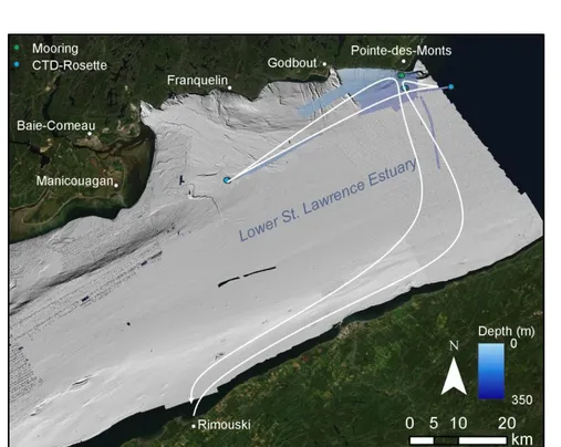
Summary of activities during COR2007. Blue shaded areas are multibeam surveys
completed during COR2007 and dots are all the samples collected or mooring deployed. ... 9
F
IGURE2:
Deployment mooring COR2001-02M ... 14
F
IGURE3:
Configuration mooring COR2007-02M showing depths below the water surface ... 15
F
IGURE4:
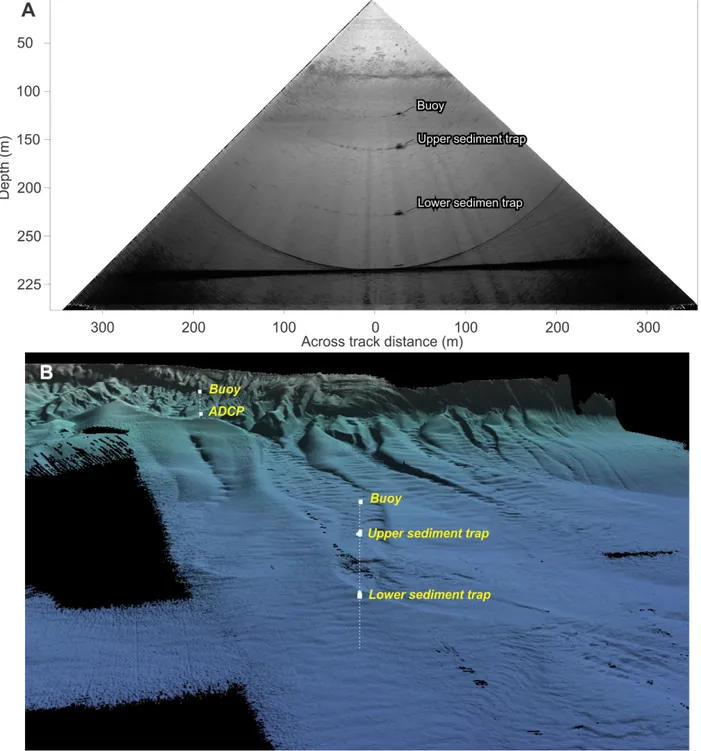
A) Multibeam echosounder imaging of mooring COR2007-02M and B) its location on
the seabed... 16
F
IGURE5:
Configuration mooring COR2007-05M showing depths below the water surface ... 17
F
IGURE6:
A) Multibeam echosounder imaging of mooring COR2007-05M and B) its location on
the seabed... 18
F
IGURE7:
Configuration mooring COR2007-23M showing depths below the water surface ... 19
F
IGURE8:
Multibeam echosounder imaging of mooring COR2007-23M ... 20
F
IGURE9:
A) Setting filtering system, B) residue captured by the 3 µm filter during filtration, C)
identification of trap cups, and D) cups attached to sediment trap ... 21
F
IGURE10:
A look at our respective tools to produce and interpret images: what resembles a
camera’s lens, and the screen where information appears. ... 23
LIST OF TABLES
T
ABLE1:
Scientific participants of the COR2007 cruise ... 8
T
ABLE2:
Summary of activities. JD – Julian Date. CTD – Conductivity-Temperature-depth. ADCP –
Acoustic Doppler Current Profiler. MBES – Multibeam echosounder ... 9
T
ABLE3:
Specifications of the EM2040 ... 12
T
ABLE4:
Mooring instruments heights above the seabed (m) ... 14
T
ABLE5:
Program used for all the sediment traps. Time and dates given as Universal Time
Coordinated (UTC) ... 21
ACKNOWLEDGMENTS
We would like to thank the Commanding Officer Hugh Dunlop, the deck crew led by boatswain Gilles Pelletier and the entire ship’s crew for its support and help during this successful mission. We thank Christian Boutot, Bruno Cayouette, Marie-Pier St-Onge (UQAR-ISMER), Pascal Rioux (UQAR-ISMER) and Erwann Fraboulet (RQM) for assistance with the mobilization and demobilization of the material, preparation of the moorings and logistics. This oceanographic expedition was supported by Réseau Québec Maritime (RQM), the Marine Environmental Observation Prediction and Response Network (MEOPAR), and the Natural Sciences and Engineering Research Council of Canada (NSERC) through Discovery Grants to A.L. and J.C.M.S.
1.
BACKGROUND AND OBJECTIVES
The northern shore of the Lower St. Lawrence Estuary (LSLE) has a rugged topography with incisions cutting across the shelf and connecting the coast to the Laurentian Channel. The presence of these submarine canyons is hypothesized to influence hydrodynamic processes, which channel and concentrate suspended sediment and nutrients, thereby possibly playing a role in local marine productivity dynamics. Submarine canyons also host some of the most powerful underwater flows, turbidity currents and landslides, which represent a threat to present or future marine infrastructures. In addition, sediment resuspension events in these highly dynamic systems may influence life stage transitions in algae that produce dormant benthic reservoirs. In the LSLE, the toxic dinoflagellate
Alexandrium catenella produces resting cysts that accumulate in shallow sediments, where they may remain viable for several decades until germination. Their capability of forming benthic seedbeds and surviving under unfavorable conditions may facilitate the development of harmful algal blooms impacting the entire ecosystem: resuspension from bottom sediment has been identified as a potential mechanism contributing to A. catenella bloom initiation. In this context, understanding the recurrence and distribution of underwater flows, turbidity currents and landslides in the LSLE is critical for marine management and to effectively forecast bloom recurrence.
The purpose of this scientific cruise was to i) deploy three bottom-anchored moorings inside (02M and 05M) and outside (23M) the Pointe-des-Monts canyon system that will collect data and suspended sediment over a one-year cycle; ii) perform continuous water column profiling during two semi-diurnal cycles at the central Pointe-des-Monts site, and iii) acquire high-resolution hydroacoustic data (high-resolution multibeam bathymetry and sub-bottom profiles) in the Pointe-des-Monts area and other proximal submarine canyons of the LSLE.
The scientific objectives are to:
1) Monitor sedimentary and hydrodynamic processes in the Pointe-des-Monts canyon system: i) monitor how sediment is eroded on the coast and transported by submarine canyons during storms; ii) monitor seasonal variations of suspended sediment provenance and transport, iii) image the behaviour of hydrodynamic processes and turbidity currents as they travel within canyons and their effect on the seafloor.
2) Determine the influence of canyon activity on primary productivity: i) document the seasonal succession and changes in primary production in the Pointe-des-Monts canyon system; and ii) investigate the potential role of sediment remobilization events for the inoculation of harmful algal blooms.
3) Collect material for work in creation: i) explore and experiment the potentialities of the encounters between art and science at the time of the Anthropocene; ii) analyze the use of the vulnerability concept in geoscience and compare it with the ethical and philosophical reflection on vulnerability; iii) reflect on the metaphor of the sediment and eco-anxiety; and iv) explore analogies and metaphors between moral and ecosystem vulnerabilities.
2.
PARTICIPANTS
Scientific participants of the COR2007 consisted of researchers from UNB, the Geological Survey of Canada, Amundsen Science, UQAR and CIDCO (Table 1).
Table 1: Scientific participants of the COR2007 cruise.
Name Organization Role
Audrey Limoges Professor, UNB Co-chief scientist
Alexandre Normandeau Research Scientist, GSC Co-chief scientist
Catherine Lalande Researcher, Amundsen Science Sediment traps
Camille Bernier M.A., UQAR Collection material creation
Christian Boutot Technician, UQAR-ISMER Deployment moorings and operations CTD-Rosette
Bruno Cayouette Technician, UQAR-ISMER Deployment moorings and operations CTD-Rosette
Dominic Ndeh Munang Hydrographer, CIDCO Hydrography
UNB: University of New Brunswick GSC: Geological Survey of Canada UQAR: Université du Québec à Rimouski
ISMER : Institut des Sciences de la mer de Rimouski
3.
SUMMARY OF ACTIVITIES
COR2007 started in Rimouski and focused mainly on the Pointe-des-Monts canyon system (Tables 2, Fig. 1). During mobilization, the three moorings were organized on deck and the acquisition room was setup. The ship sailed with the high tide in the evening of October 13.
Sampling activities during COR2007 included the deployment of three moorings (DM), CTD profiles, hydroacoustic surveys and the collection of material for the literary part of the project (i.e., photos, thoughts, fragments, interviews).
Table 2. Summary of activities. JD – Julian Date. CTD – Conductivity-Temperature-depth. ADCP – Acoustic Doppler
Current Profiler. MBES – Multibeam echosounder.
Date JD Location CTD Mooring EK-60 ADCP 3.5 KHz MBES Notes
Oct. 13 287 Rimouski X X Mobilization
Oct. 14 288 Pointe-des-Monts 2 1 X X
Oct. 15 289 Pointe-des-Monts, Manicouagan
2 2 X X
Oct. 16 290 Pointe-des-Monts 4 x X X X
Oct. 17 291 Pointe-des-Monts x x X x Demobilization
TOTAL 8 3
Figure 1: Summary of activities during COR2007. Blue shaded areas are multibeam surveys completed during
4.
DAILY NARRATIVE
4.1 JD287 – October 13 – Rimouski
The science crew arrived at the dock around 9:10. The mobilization team from UQAR arrived at the dock around 9:30. The mobilization took place from 9:30 to 12:00. After the familiarization of the vessel and safety briefing, which occurred at 15:30, the filtering system was installed. The ADCP mooring (02M) was prepared for the deployment of the following day. The R/V Coriolis II then sailed off with the high tide of 21:00, heading directly towards Pointe-des-Monts. During the night, hydroacoustic surveys of the bottom part of the Pointe-des-Monts canyon began.
4.2 JD288 – October 14 – Pointe-des-Monts
The hydroacoustic surveys ceased at 8:00 when we transited towards the deepest part of the Laurentian Channel near Pointe-des-Monts, at a depth of 340 m. At 8:30, the CTD-Rosette (COR2007-01) was deployed to collect seawater from a water depth of 310m. The seawater was filtered through 3 and 0.2µm filters from 9:00 to 12:30. Following the collection of water samples, we transited towards site 02M where the ADCP mooring was deployed from 9:30 to 10:05. The mooring was successfully deployed in the canyon. The position of the mooring was found using two methods: 1) by triangulation using an over the side USBL and 2) by imaging the mooring with the multibeam echosounder. The multibeam echosounder imagery is considered more precise for positioning the exact location of the mooring. A CTD (COR2007-02) was then done near station 02M. Immediately following the CTD, we continued surveying the Pointe-des-Monts canyon system, starting by the shoreline. During the hydroacoustic surveys, a Formaldehyde solution was prepared, and the sediment trap cups were filled and installed on the two 05M instruments (A, B). Hydroacoustic surveys continued overnight.
4.3 JD289 – October 15 – Pointe-des-Monts
Overnight, the Godbout region was mapped after the completion of the Pointe-des-Monts canyons. Around 7:30, we began transiting towards station 05M while mapping the area near the shoreline. When on position, a CTD (COR2007-03) was done at station 05M from 9:09 to 9:21. The deployment of the mooring 05M started at 9:54 and was completed at 11:27. The position of the mooring was also found by triangulation and imaged with the multibeam echosounder. We then sailed directly to station 23M, where a CTD (COR2007-04) was done from 14:07 to 14:16. Deployment of mooring 23M started at 14:33 and was completed by 14:56. The position of the mooring was again found by triangulation and
visualized with the multibeam. Overnight, hydroacoustic surveys were done to complete the coverage between Godbout and Pointe-des-Monts.
4.4 JD290 – October 16 – Pointe-des-Monts / Manicouagan
A continuous CTD cycle started at 8:02, with the low-tide (COR2007-05) in conjunction with a continuous monitoring of the water column with the EK-60 and the hull-mounted ADCP. A 200 m-diameter buffer zone was defined around a location near mooring 02M to help with the ship maneuvers, and especially to avoid contact with mooring 02M. The temperature of the oil of the winch was measured occasionally to prevent overheating. A threshold of 65°C was established. The weather conditions were ideal for the operation and the captain/1st officer successfully kept a very stable position for the complete cycle. Around 20:00, it was determined that if conditions were to become more challenging during the night, the CTD-Rosette could be deployed at intervals of 30 min. However, the captain/1st officer, technicians and crew were able to maintain the operation without interruption. The continuous cycle of CTD-R continued overnight.
4.5 JD291 – October 17 – Pointe-des-Monts / Rimouski
The CTD cycle was completed by 9:30. Before heading back to Rimouski, hydroacoustic survey lines were done to cover small uncompleted areas observed after preliminary processing. The ship arrived in Rimouski at 16:30. The scientific crew, with the exception of Dominic and Bruno, stayed onboard overnight.
4.6 JD292 – October 18 – Rimouski
At 9:00, the demobilization team arrived, and the demobilization was completed by 10:30. The blank formalin solution cup, spare sediment traps and cup lids were transported to UNB.
5 EQUIPMENT AND PROCEDURES
Edgetch X-Star 2.1 sub-bottom profilerThis sub-bottom profiler allows the acquisition of high-resolution subsurface data (sediment stratigraphy). The echo sounder transmits FM acoustic waves (0.5 to 12 kHz, centered on 4.5 or 6 kHz) with 9 transducers that serve as both transmitters (TX) and receiver (RX). During the cruise, the data
from the EdgeTech echosounder were all acquired using the seismic wave (pulse) Hull 2_8_40WB (frequency modulation from 2 to 8 kHz, pulse duration of 40 ms) and a frequency of 3 Hz. The acquisition and visualization of the profiles was done with the version 2.1 of the Edgetech Discover X-Star software. However, the raw JSF data were converted to SegY following a routine conversion. The SegY data were then converted into JP2 format using SegyJp2 software.
EM-2040 multibeam echosounder
The EM-2040 is a shallow-water multibeam echosounder (MBES) that allows the mapping of the seabed at a maximum depth of ~500 m. A transducer (TX) emits an acoustic wave that is reflected from the seabed and picked up by a receiver (RX). The EM-2040 echosounder operates at a frequency that varies between 200, 300 and 400 kHz depending on the depth and resolution required. It has 400 pings per swath and allows coverage of 5.5 times water depth. During this expedition, a frequency of 300 kHz was used, which allowed mapping the seabed to a maximum depth of 480 m while maintaining a very good resolution. An Applanix POS M/V was positioned near the center of gravity of the ship to record the motion of the vessel and the data were integrated using the multibeam echosounder’s acquisition software (SIS). The static and dynamic calibrations (patch tests) were carried out at the beginning of the expedition. The MBES data were processed using the CARIS software during the night watches and gridded surfaces were ready to view in the morning (~7h00). Final surfaces can be gridded at 2 m horizontal resolution.
Table 3: Specifications of the EM2040.
Beams 400 (HD Equi-Distant)
Frequency 200kHz - 400kHz (used 300 kHz)
Swath Greater than four times water depth
Max Swath Angle 120 degrees
Depth Range 10m-500m
In order to georeference MBES data, sound velocity profiles (SVP) were done during the surveys. SVPs are used to correct the ray tracing of the MBES data. The most efficient way to perform sound velocity profiles was to stop the vessel and deploy the profiler with a winch. This operation was performed 3 times during each night of mapping operations: 1) at the beginning, during the day/night shift transition, 2) in the middle of the night, and 3) at the night/day shift transition. This deployment required two persons: 1 hydrographer and 1 deck assistant (winch operator). During this expedition the SVP AML Minos sensor was used. This sensor was lowered in the water column using a weight of approximately 9 kg (20 lbs). It is suggested to use up to 3 shackles available in the BOSEN store during this operation. The
assembly to lower the profiler requires a pulley to direct the rope to the aft deck of the vessel. For the deployment, the profiler was attached with a shackle on the rope and lowered at the water level with the winch. The winch counter was reset to 0 and the probe was deployed to 90% of the last observed depth at a speed of ~90 m/min (1.5 m/s). The probe was then brought back up and recovered by the hydrographer. The hydrographer then integrated the SVP profile in the SIS acquisition software to calibrate the MBES data.
Conductivity-Temperature-Density (CTD)-Rosette
The CTD-Rosette is equipped with 12 Niskin-type bottles of 12 L with an automatic closing system that allows the sampling of seawater at specific depths. A CTD probe, which continuously measures the conductivity, temperature, density, dissolved oxygen, pH, % light transmission and the fluorescence is also attached to the rosette. During the first day of the expedition, seawater was collected, filtered and used to prepare the formalin solution of the sediment trap cups. Deployment steps were as follows: 1) Immerse the rosette in the surface (about 5 meters) and turn the pump on; 2) Wait 30 seconds for the plumbing system to flush (check that the probes stabilize); 3) Start archiving (recording) in SeaSave; 4) Descend at 1 meter/second, starting to slow down around 20 meters from the bottom by checking the altimeter to stop at 10 meters from the bottom; 5) At the required water depth, wait 30 seconds (wave stabilization) and then close required bottles; 6) ascend; 7) Once at the surface and water sampling has been completed, turn the pump off; 8) Stop archiving and close deck unit.
For the 25hour CTD cycle, the rosette-CTD was immerged at all time, except for occasional verifications.
Moorings
The moorings were prepared on the rear deck and positioned strategically. They were deployed using the main winch from the upper float to the anchor. The configuration of the mooring 02M follows recommendations by Urs Neumeier and Daniel Bourgault and detailed in Normandeau et al. (2020) and Clare et al. (2020). A sketch of the moorings was provided to an observer during the deployment to verify that all the instruments were properly added. To facilitate the deployment, the cables were rolled in the main winch and each joint was clearly identified. Following the mooring deployment, their exact location on the seabed was found by logging the water column with the multibeam echosounder. Water column imaging allowed to precisely identify each part of the moorings and extract their precise location (Figs. 9-13).
The CTDs were programmed to record data continuously at intervals of 3 seconds. More details on the sediment traps can be found below.
Three different moorings were deployed and are described below (Table 4): Table 4: Mooring instruments heights above the seabed (m).
COR2007-02M COR2007-05M COR2007-23M
Upper float 78 160 99
Upward looking ADCP 28.5 - -
CTD 28 - -
Downward looking ADCP 27.5 - -
Sediment trap (A) - 128 67
CTD 5 127.10 66.10
Sediment trap (B) - 58 -
CTD - 57.1 -
Figure 2. Deployment mooring COR2001-02M.
A B
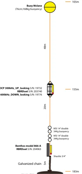
Mooring COR2007-02M (Figs. 3-4) was deployed in the main Pointe-des-Monts canyon and consisted of an upward and downward-looking Acoustic Doppler Current Profiler (ADCP) and CTD sensors.
Figure 3. Configuration mooring COR2007-02M showing depths below the water surface. Target Latitude: 49.28385°N Target Longitude: -67.379767°W Target depth: 180m Depth deployed: 183m MBES Latitude: 49.30654°N MBES Longitude: -67.392407°W Date deployment: 14 October Time deployment: 10:05
Mooring COR2007-05M (Figs. 5-6) was deployed at the exit of the main Pointe-des-Monts canyon and consists of two sediment traps and CTDs.
Figure 5. Configuration mooring COR2007-05M showing depths below the water surface. Target Latitude: 49.28385°N Target Longitude: -67.379767°W Target depth : 278m Depth deployed : 282m MBES Latitude : 49.284065°N MBES Longitude : -67.381588°W Date deployment : 15 October Time deployment : 11:27
Mooring COR2007-23M (Figs. 7-8) was deployed offshore Baie-Comeau and consists of one sediment trap and a CTD.
Figure 7. Configuration mooring COR2007-23M showing depths below the water surface. Target Latitude: 49.117766°N Target Longitude: -67.881886°W Target depth: 202m Depth deployed: 200m MBES Latitude: 49.11802°N MBES Longitude: -67.883035°W Date deployment: 15 October Time deployment: 14 :56
Figure 8. Multibeam echosounder imaging of mooring COR2007-23M.
The time-programmed (see Table 6), multi-cupped (12 x 520 mL sample cups) sediment traps
were deployed at sites 05M and 23M. Prior to the deployment, the sediment trap cups were
filled with a preservative formalin solution (Hargrave et al., 2002). To prepare the solution,
seawater collected at 310m depth was filtered twice: i) first on a 3 µm, 142 mm diameter A/D
glass fiber filter, ii) then on a 0.2 µm GTTP membrane filter (Fig. 4). Approximately 13L of
formalin solution was prepared per trap. Leftover formalin solution will be used to measure
blank values for elemental analyses and chlorophyll measurements (CHN + fluorimeter).
Solution recipe: 12.35 L of filtered seawater + 650 ml of formaldehyde 37% + 65 g borax (20
Mule Team borax) + 61.75 g NaCl.
The labeling of the trap cups is as follows:
Station (e.g., 05M)
Years of collection (2020-2021)
Figure 9. A) Setup filtering system, B) residue captured by the 3 µm filter during filtration, C) identification of trap
cups, and D) cups attached to sediment trap.
Table 5. Program used for all the sediment traps. Time and dates given as Universal Time Coordinated (UTC).
Sample Days Date
1 15 16-October-20 00:00:00 2 15 31-October-20 00:00:00 3 15 15-November-20 00:00:00 4 15 30-November-20 00:00:00 5 16 15-December-20 00:00:00 6 15 31- December -20 00:00:00 7 16 15-January-21 00:00:00 8 15 31-January-21 00:00:00 9 13 15-February-21 00:00:00 10 15 28-February-21 00:00:00 11 16 15-March-21 00:00:00 12 15 31-March-21 00:00:00 13 8 15-April-21 00:00:00 14 7 23-April-21 00:00:00 15 16 30-April-21 00:00:00 16 15 16-May-21 00:00:00 17 15 31-May-21 00:00:00 18 15 15-June-21 00:00:00 19 16 30-June-21 00:00:00 20 15 16-July-21 00:00:00 21 16 31-July-21 00:00:00 22 15 16-August-21 00:00:00 23 15 31-August-21 00:00:00 24 15 15-September-21 00:00:00 END 30-September-21 00:00:00 A B C D
Collection of creative material
A great amount of material and information for the writing, thinking and creation was
collected. The equipment used to collect material included an audio recorder, film cameras, a
digital camera, computer and notebook. Important focus was placed on the iterations of
vulnerability related to the mission: related to the research and knowledge themselves, that of
the different crew members and different roles and task distribution among them, related to
the work environment (the boat, the equipment, the river and the riverbed), and the necessary
preciseness of all operations. In other words, the sum of interactions with constraints, whether
human, material or environmental. Planned and spontaneous questions and conversations
were of immense help to create a rich image of the variables that build such a mission over
time. The sediment, as metaphor, promises a solid link for long-term research between the
natural and social disciplines. Its composite conceptual possibilities, combined with the material
data being produced and archived, allows it to become a tool for further thought about the
reading of information itself, as well as what interferes – and what comes after acquisition of
data (its sharing, application, interpretation). The images being used during the mission as
writing and navigating tools resemble the role of the metaphor in a literary text: to create, by
innovative imagery, a path to foster meaning. The totality of the forms of vulnerability we work
with, related to the permanent possible loss of material and hypothetic knowledge, speaks of
the value of the work addressing the viability of information, dependant of its own delicate
environment.
Looking for images, as well as creating them, or tracing their outlines, has been a way to better
understand the objectives of the various images produced during this mission by all the crew
members. The observer tries to photograph, as well as write about, moments that could
happen both without my presence, and moments stirred by specific questions. With
photography, as well as writing with metaphors, one produces images patiently, and never
alone: the interest of the image produced does not belong only to the photographer or writer,
but depends on what is “captured”, who interprets the image, and what will be made of it. The
material, physical and chemical process between the moment the shutter is activated, and the
developed film, and then the visible image printed on paper, is a miniature image in itself of the
length and work of such a research project on the sediment that could be witnessed on the
Coriolis II. Coming too close to what is observed (be it the working crew, or the bottom of the
submarine canyon) comes with the risk of “creating turbidity”, interacting in a disrupting way
with the observed environment.
Figure 10. A look at our respective tools to produce and interpret images: what resembles a camera’s lens, and the
screen where information appears.
6 CONCLUSIONS AND RECOMMENDATIONS
COR2007 allowed the successful deployment of the three moorings inside and outside the Pointe-des-Monts canyon system, a continuous 25 hours of CTD profiling in the central Pointe-des-Pointe-des-Monts canyon system and the collection of material for the literary part of the project. The scientific and technical crew formulated the recommendations below for recovery and future deployments:
Operational recommendations for the deployment of moorings:
Allow sufficient time and space on deck for the preparation and deployment of the moorings. Limit the size of each mooring segment to facilitate the deployment and ensure the safety of the
operators.
The safety lock of the mechanical release should never be removed until all the instruments are in, or close to, the water.
Scientific recommendations:
Edgetech sub-bottom profiler: The new version of the Edgetech logs both .jsf and .sgy. There appears to
be a setting that breaks the lines into small files, which we could not find how to correct. The settings should be verified before the next cruise.
Filtration of seawater and preparation formalin solution: It would be easier to use rigid containers for
the formalin solution, preferably with a faucet to pour the solution without being exposed to the solution vapors.
Recovery of sediment traps:
Bring the lids for the sample cups
Bring formalin solution to add to sample cups presenting signs of degradation (if any). If redeployment: consider using the 250 ml sample cups if not filled = reduce the amount of
solution.
7 REFERENCES
Clare, M., Lintern, D.G., Rosenberger, K., Clarke, J.E.H., Paull, C., Gwiazda, R., Cartigny, M.J.B., Talling, P.J., Perara, D., and Xu, J., 2020, Lessons learned from the monitoring of turbidity currents and guidance for future platform designs: Geological Society, London, Special Publications, v. 500, p. 605–634.
Hargrave, B.T., Walsh, I.D., and Murray, D.W., 2002, Seasonal and spatial patterns in mass and organic matter sedimentation in the North Water: Deep Sea Research Part II: Topical Studies in Oceanography, v. 49, p. 5227–5244.
Normandeau, A., Bourgault, D., Neumeier, U., Lajeunesse, P., St-Onge, G., Gostiaux, L., and Chavanne, C., 2020, Storm-induced turbidity currents on a sediment-starved shelf : Insight from direct monitoring and repeat seabed mapping of upslope migrating bedforms: Sedimentology, doi: 10.1111/sed.12673.
APPENDIX A – Station summary
Table A1: Summary of mooring stations deployed during COR2007 Station number Date
(d/m/y) Location Time (24hr, ET) Latitude(deployed) Longitude (deployed) Latitude (MBES) Longitude
(MBES) Water depth 02M 14/10/20 Pointe-des-Monts 10:05 49.30663 -67.39198 49.30654 -67.39241 183 05M 15/10/20 Pointe-des-Monts 11:26 49.28368 -67.3788 49.284065 -67.38159 282 23M 15/10/20 Manicouagan 14:56 49.11802 -67.88241 49.11802 -67.88304 200
Table A2: Summary of CTD stations during COR2007
Station number COR2007 ID Date Location Time Latitude Longitude Water depth (m)
SW 01 14-10-2020 Pointe-des-Monts 8:19 49.2830 -67.2488 345 02M 02 14-10-2020 Pointe-des-Monts 11:02 49.3072 -67.3962 180 05M 03 15-10-2020 Pointe-des-Monts 8:58 49.2853 -67.3857 282 23M 04 15-10-2020 Manicouagan 14:02 49.1178 -67.8825 200 02M 05 16-10-2020 Pointe-des-Monts 8:00 49.3076 -67.3942 175 02M 06 16-10-2020 Pointe-des-Monts 10:35 49.3076 -67.3942 175 02M 07 16-10-2020 Pointe-des-Monts 15:09 49.3076 -67.3942 175 02M 08 16-10-2020 Pointe-des-Monts 23:37 49.3076 -67.3942 175