Stéphanie Duchêne Cécile Gautheron Carole Petit Riccardo Vassallo Eduardo Campos Rodrigo González Sébastien Carretier Rodrigo Riquelme Stéphanie Brichau Vincent Regard
Professeur, Université Paul Sabatier, Toulouse Professeur, Université Paris Sud, Orsay Professeur, Université Sophia Antipolis, Nice
Maître de conférences, Université Savoie Mont-Blanc, Chambéry Associate professor, Universidad Catolica del Norte, Antofagasta Research associate, Universidad Catolica del Norte, Antofagasta Directeur de recherche IRD, GET, Toulouse
Associate professor, Universidad Catolica del Norte, Antofagasta Chargée de recherche IRD, GET, Toulouse
Maître de conférences, Université Paul Sabatier, Toulouse
Présidente Rapporteur Rapporteur Rapporteur Examinateur Examinateur Directeur Directeur Invitée Invité
en co-tutelle avec la Universidad Católica del Norte, Antofagasta, Chili
Sébastien Carretier (GET, France) Rodrigo Riquelme (UCN, Chili)
Jury
Co-encadrants de thèse :
Directeurs de thèse :
Stéphanie Brichau (GET, France) Vincent Regard (GET, France)
5
Abstract
: During the Middle Eocene in the Atacama Desert region (northern Chile), the intrusion of porphyries and the synchronous deformation of the Precordillera resulted in the formation of important clusters of supergene and exotic copper ore deposits that are currently exploited. Such metal ore deposits result of the interaction of tectonics, erosion and climate, for which both timing and relations remain debated. This PhD study focuses on the quantification of geomorphological, tectonic and erosive processes to understand their relationship in the Andean western slope around 23°S in the Centinela district in the Precordillera. Twenty-nine new low-temperature thermochronological data and their modelling indicate that shallow porphyry copper emplaced during mid-Eocene were quickly exhumed near the surface by the early Oligocene. There is a five million years-long time gap between the exhumation of primary source of copper and the ~25-12 Ma range of existing 40Ar/39Ar and K/Ar ages of secondary mineralization in the District. This suggests that supergene copper related deposits occurred when the reliefs where already flattened. A syn-sedimentary exotic copper mineralization was deposited in an intra-mountainous basin in the Centinela District. We sampled sand at different depths between 135 and 13 meters in the Tesoro and Mirador open-pit mines, one of them including this exotic deposit. The 10Be and 21Ne concentrations of fourteen new samples were used to determine the exotic deposit age and to constrain the paleo-sedimentation rate for the last 14 Ma. The study dates the exotic deposit at ~12 Ma and suggests that this mid-Miocene exotic layer occurred during an erosive quiescence, confirming the view that supergene copper mineralization occurs during a stage of slower geomorphic activity in arid environments. The results also confirm that the erosion rates drastically dropped after 10-12 Ma, when the hyperaridity was established. This study highlights the necessary balance between exhumation and precipitation rates required to form secondary copper.Key words:
Supergene copper ore deposit, low-temperature thermochronology, Atacama Desert, cosmogenic nuclides.6
Résumé :
Pendant l’Eocene Moyen, dans la région du désert d’Atacama, Nord Chili, la mise en place de porphyres et la déformation synchrone de la Précordillère aboutissent à la formation de clusters importants de dépôts de cuivre supergènes et exotiques, actuellement en cours d’exploitation. La formation de ces dépôts métallifères résulte de l’interaction entre la tectonique, l’érosion et le climat. La nature et la chronologie de ces interactions sont encore débattues. Ce travail de doctorat se concentre sur la quantification des processus géomorphologiques, tectoniques et érosifs, sur le versant ouest des Andes, autour de 23°S dans le District minier Centinela situé dans la Précordillère. Vingt-neuf nouvelles données thermochronologiques basse-température et leur modélisation indiquent que les porphyres cuprifères mis en place à faible profondeur durant l’Eocène moyen étaient déjà exhumés près de la surface à l’Oligocène moyen. Il existe un intervalle de temps de cinq millions d’années entre l’exhumation du porphyre qui constitue la source primaire de cuivre et le dépôt secondaire de cuivre dans le district de Centinela daté par les méthodes 40Ar/39Ar et K/Ar. Cette relation suggère que les dépôts de cuivre secondaires ont eu lieu lorsque les reliefs étaient déjà aplanis. Un dépôt exotique cuprifère syn-sédimentaire s’est formé dans le bassin continental du district Centinela. Des échantillons de sable ont été prélevés entre 135 et 13 mètres de profondeur dans les mines El Tesoro et Mirador. Les concentrations en 10Be et 21Ne de quatorze nouveaux échantillons ont permis de déterminer l’âge du dépôt et de contraindre les paléo taux de sédimentation des derniers 14 Ma. L’étude permet de dater le dépôt exotique à ~12 Ma et suggère qu’il a eu lieu lors d’une quiescence des taux d’érosion, confirmant l’idée que les dépôts supergènes de cuivre en milieu aride ont lieu après l’aplanissement des reliefs. Ces résultats confirment aussi que les taux d’érosion ont drastiquement chuté après 10-12 Ma, quand l’hyperaridité s’est établie. Ce travail de thèse illustre la balance nécessaire entre l’exhumation et les taux de précipitation pour former des minéralisations secondaires de cuivre et les conserver.Mots-clés :
Dépôt de cuivre supergène, thermochronologie basse-température, désert d’Atacama, nucléides cosmogéniques.7
Resumen:
Durante el Eoceno medio, en la región del desierto de Atacama, en el norte de Chile, la ubicación y deformación sincrónica de la Precordillera generó la formación de depósitos significativos de cobre, ambos supergénicos y exóticos, los que se encuentran actualmente en explotación. Tales formaciones de metales resultan de la interacción de procesos tectónicos, erosivos y climáticos por los cual aún se debaten la sincronización y las interacciones que los produjeron. Esta tesis doctoral se enfoca en la cuantificación de los procesos geomorfológicos, tectónicos y erosivos, y sus interacciones, en la vertiente occidental de los Andes, alrededor de 23°S en el Distrito Minero Centinela, situado en la Precordillera. Veintinueve nuevos datos termocronológicos de baja temperatura y sus modelados indican que los porfiros cupríferos se emplazaron a poca profundidad en el Eoceno medio y que se habrían exhumado cerca la superficie en el Oligoceno medio. Existe un período de tiempo de cinco millones de años entre la exhumación de la fuente primaria de cobre y el rango de edades 40Ar/39Ar y K/Ar de los depósitos secundarios de cobre en el distrito Centinela. Esta relación sugiere que los depósitos de cobre secundario tuvieron lugar cuando los relieves ya estaban aplanados. Un depósito de cobre sin-sedimentaria de cobre exótico ocurrió en los sedimentos de la cuenca continental del distrito Centinela. Para determinar la edad del depósito y cuantificar la velocidad de paleo-sedimentación, se recogieron muestras de arena entre 135 y 13 metros en las minas El Tesoro y Mirador. Las concentraciones de 10Be y 21Ne de catorce nuevas muestras se utilizaron para datar el deposito exótico y cuantificar las paleo tasas de sedimentación de los últimos 14 Ma. El estudio nos permite datar el depósito exótico a ~12 Ma, sugiriendo que pasó por un momento de quietud erosiva, lo que confirma la hipótesis de que en ambientes áridos, los depósitos de cobre exóticos se producen durante la etapa de baja actividad geomorfológica. Estos resultados también confirman que las tasas de erosión se han reducido drásticamente después de 10-12 Ma, cuando empezó la hiperaridez en el desierto de Atacama. Este trabajo ilustra el equilibrio necesario entre la exhumación y la tasa de precipitación para formar mineralización de cobre secundario.Palabras claves: Depositos supergenos de cobre, termocronología baja-temperatura, Desierto de
9
Acknowledgments
Those acknowledgments will be representative of the conditions in which this work has been realized,
meaning by that: in a constant exchange between Chilean and French countries, cultures and so, two languages. I
choose to carry it out in the chronologic order and hopefully exhaustively enough to thank everyone for the help
received during this life experience.
Premièrement, merci à Cécile Gautheron, Carole Petit et Riccardo Vassallo d'avoir accepté d'évaluer ce
travail ainsi qu'à Stéphanie Duchêne pour présidez le jury et tous les membres du jury pour l’examination de ce
travail.
Siendo el primero con quien intercambié, quiero agradecer a Rodrigo Riquelme, para proponer esta tesis.
Fue una travesía, con un aprendizaje científico y humano que quedara para siempre, y los terrenos en el Desierto
de Atacama no se pueden olvidar. Ensuite, je tiens à remercier Sébastien Carretier, pour sa persistance et rigueur
tout au long de ce travail d’encadrement et d’enseignement. Ce travail n'aurait pas pu être possible sans Stéphanie
Brichau et les nombreuses heures de formation à la thermochronologie basse température, depuis l'échantillonnage
au décorticage des modèles numériques. Merci pour ton soutien sans faille qui est toujours actif ! Merci à Vincent
pour les échanges scientifiques et humains, de la manipulation d'acide à la création du code ainsi que ses nombreux
ajustements nécessaires au fil du temps.
Estoy muy agradecida de haber recibido apoyo de la Universidad Catolica del Norte y de la Conicyt que
permitio financiar parte de este trabajo. Merci également à l’IRD et l’université Paul Sabatier de Toulouse pour le
financement de trajets entre le Chili et la France, et de mon salaire.
Quiero agradecer de forma general a todos lo que me han ayudado y con quien he compartido en el
departamento de Geología de la UCN en Antofagasta. En particular, gracias a Eduardo Campos, por su apoyo
constante desde mi llegada hasta la defensa, gracias à Hans Wilke y Rodrigo Gonzalez, y a todo el cuerpo docente
con quien he podido intercambiar. Gracias también a Thomas Bissig por sus clases y por las conversaciones
constructivas que pudimos tener. Merci à Gérard Hérail pour avoir accompagné les terrains de cette thèse et les
discussions partagées.
Les résultats présentés dans cette thèse ont été obtenu dans plusieurs laboratoires alors j’adresse un grand
merci à l'équipe de Géosciences Montpellier, Patrick Monié et Michael Bonno en particulier, pour leur accueil lors
des nombreux séjours et pour les analyses (U-Th)/He effectués. Je souhaite également remercier Pierre-Henri Blard
et l’équipe technique pour m'avoir aussi bien accueilli à Nancy, au CRPG et initié au maniement du Helix-SFT
pendant de longues journées.
Gracias al cuerpo docente para aceptar mí presencia en el departamento de Geología de la Universidad de
Chile durante un año, para poder utilizar el laboratorio de termocronologia. Y en particular a Marcelo Farías
para los intercambios científicos y su apoyo, hasta en la central nuclear de Santiago. Gracias a Miguel Tapia,
Constantino Mpodozis y Carlos Marquardt para toda la ayuda en el distrito Centinela y también a Antofagasta
Minerals.
10
Merci à Jérôme Ganne pour cette initiation à la thermobarométrie, ainsi que Phillipe de Parseval pour
l'utilisation de la micro-sonde. Merci aussi à Sonia Rousse pour son soutien.
Gracias a Xeomara y toda la gente por la buena onda, la ayuda y los numerosos documentos
intercambiados para realizar los trámites en la UCN en Antofagasta.
Puis finalement, je tiens à remercier toute l'équipe technique du GET, Jeff, Ludo pour m'avoir aidé...
ouvert si souvent les salles durant les longues heures de préparation des échantillons. Merci également à Sabine
pour sa précieuse aide pour pourvoir réussir à faire tous ces missions. Rose-Marie y Nelda, gracias también por su
ayuda y su cariño en las oficinas del IRD en Santiago.
Gracias a todos los doctorantes de la UCN por esta compañía. Especialmente a Joaquin, con tu tremendo
apoyo muy importante en particular el primer año de tesis. Gracias a Ines, para siempre abrir las puertas de tu
hogar. Gracias a Andrea, Benigno, Ian, Alberto, Albert, Pasten, Guti y todos los demás para acogerme. Cristopher,
gracias por los buenos intercambios científicos que tuvimos. Gracias a todos los demás con quienes siempre se ha
compartido un asadito y que no tuve suficiente tiempo para conocerlos. Tremendo gracias especial a Dani por todo
el apoyo que he tenido la suerte de recibir. Gracias tambien a todos los doctorantes de la Chile, por la buena onda
y el apoyo, Mary, Vale, el primo Pablo... Un abrazo especial va a los amigos de largo plazo Pablo, Carterrrrito
por estar siempre ahí, mientras los años pasan y Bopu por siempre compartir también, año por año, haciendo
olvidar que la distancia puede ser un obstaculo para la amistad.
Merci aux compagnons thésards du laboratoire Géosciences Environnement Toulouse. Premièrement à Sofy,
les grandes rencontres que tu as induites et les repas partagés. Touffe, merci d’avoir été présent et de continuer à
l’être. Mention spéciale à Paulo, pour l’encouragement dans la fin de l’exercice cotutelle Amérique du Sud ! Merci
Léandre, M. Boutin, M. Leleu, JLG, Mélo, Pierre, Lucie, Alis, Cristina et tous les autres… Les allers-retours
montpelliérains m’ont donné la grande chance de faire rentrer Laure dans ma vie, et de retrouver Anaïs, merci à
vous aussi pour votre soutien !
Obviamente no podría olvidar agradecer a los amigos de la ROC y las aventuras ornitólogas compartidas,
a los Feñas, el Patrich, el Inti, Pato, Fabrice, la Montse y los demás por los pulentos momentos a descubrir la
zona central y otros rincones sureños. ¡Ojalá iremos para más en el futuro, donde sea !
Merci aussi aux copains naturalistes en France, en particulier Romain et Vadim pour la bouffée d’air
frais que procurent la recherche et l’observation de petites bêtes sauvages.
Un grand merci pour tout le soutien logistique sans lequel la dernière année n’aurait pas pu être possible :
Alex merci pour tout ! Vivent St Paulet et ses aventures. Sofia : merci pour ton soutien de co-bureau de choc. Merci
également à Anne et toutes les autres personnes qui ont pu me dépanner d’une manière ou d’une autre. Un énorme
merci à Mme Garaios.
Et de manière continue, merci à ceux de "toujours". Boris de m'avoir soutenu depuis le début et les cours
de carto ! Merci à Vio pour ta bienveillance perpetuelle. Merci à maitre Am’ depuis la licence. Merci à Cécile pour
ta gaiété et ton soutien à distance pour l’exercice de la cotutelle. Merci à toi coloc Hélène pour le plaisir de partager
des moments apaisants à s’écouter.
11
Merci à toi Anna, d’être là depuis le M2. Loulou, merci d’être là depuis xx années ! Popo, merci aussi
d’être là dans les bons et moments plus difficiles ! Christophe et Julien, merci pour votre patience, vos
enseignements et riches moments partagés. Babeth, merci pour ta compagnie et ta présence, même à distance.
Evidemment, merci à toi Ade, de toujours te soucier. Merci tout spécial à toi, Malo, pour l'inconditionnel soutien
à distance et dont les innombrables heures passées au téléphone.
Merci à mes parents pour leur soutien dans mes envies de « cailloux » depuis la plus tendre enfance. De
m'avoir donné le goût, parfois trop prononcé, de la débrouillardise, qui fait que bon an mal an, les projets se
concrétisent, tout comme le bol de noisette se remplit.
Et finalement, merci à toi, Xavier, qui m'a soutenu à distance, puis au quotidien, puis en traversant
l'océan Atlantique pour suivre de folles escapades wabisabiennes.
13
Contents
Chapter 1 Introduction ... 19
English version ... 19
Version en français ... 25
References for Chapter 1 ... 29
Chapter 2 State of the art ... 31
Abstract ... 31
2.1 Geology of the Andes and the Atacama Desert ... 32
2.1.1 Generalities ... 32
2.1.2 Andean segmentation ... 34
2.1.3 Geology of northern Chile in the region of Antofagasta ... 34
2.1.3.1 Lithology ... 35
2.1.3.2 Structural framework ... 40
2.1.3.3 Exhumation quantification ... 41
2.2 Climate of the Atacama Desert ... 43
2.2.1 Definition ... 43
2.2.2 Why is northern Chile a desert? ... 43
2.2.3 Since when? ... 45
2.3 Atacama geomorphology... 47
2.3.1 Atacama pediplain ... 47
2.3.2 Geomorphological models of pediments under arid climate ... 47
2.3.3 Methods that permit to date landscapes ... 51
2.4 Copper Supergene mineralization ... 51
2.4.1 Principles ... 51
2.4.1.1 Hypogene mineralization ... 51
2.4.1.2 Supergene mineralization ... 52
2.4.2 Supergene mineralization in the Atacama Desert ... 54
References for Chapter 2 ... 57
Table of Figures for Chapter 2 ... 65
Chapter 3 Methodology ... 67 Abstract ... 67 3.1. Introduction ... 68 3.2 Thermochronology ... 70 3.2.1 Sample preparation ... 71 3.2.2 U-Pb dating ... 72
14
3.2.3 Fission track analyses ... 73
3.2.3.1 Principles ... 73
3.2.3.2 Fission track annealing ... 74
3.2.3.3 Counting specificities ... 76
3.2.3.4 Fission track mount preparation ... 78
3.2.4 (U-Th)/He ... 78
3.2.4.1 Principles ... 78
Production ... 78
He diffusion ... 79
3.2.4.2 Measurement ... 81
3.2.5 Modelling the temperature-time cooling path ... 83
3.3 Cosmogenic nuclides ... 84
3.3.1 What are cosmic rays? ... 85
3.3.2 How cosmogenic nuclides are produced? ... 86
3.3.3 Cosmogenic nuclides diversity and characteristics. ... 87
3.3.4 Production rates ... 88
3.3.5 Acquisition ... 89
3.3.5.1 Sampling and quartz separation ... 89
3.3.5.2 Measurement ... 90
3.3.6 Geomorphological quantifications ... 91
3.3.6.1 Dating surfaces. ... 91
3.3.6.2 Local Erosion rate quantification ... 93
3.3.6.3 Burial dating ... 94
3.4 Thermobarometry ... 96
References for Chapter 3 ... 97
Table of Figures for Chapter 3 ... 102
Chapter 4 Forearc cooling history at 23°S and geomorphic implications ... 105
4.1 Introduction ... 106
4.2 Geological setting ... 107
4.2.1 Regional Scale ... 107
4.2.2 Morpho-structural unit scale ... 110
4.2.2.1 The Costal Cordillera ... 110
4.2.2.2 The Central Depression. ... 110
4.2.2.3 The Precordillera ... 111
4.2.2.4 Pre-Andean Depression or Salar de Atacama ... 112
4.3 Methods ... 113
15
4.3.2 Low thermochronology methodology ... 115
4.3.3 Thermobarometry ... 115
4.4 Results ... 116
4.4.1 Age results ... 116
4.4.3 Thermal modelling ... 121
4.4.3.1 The Coastal Cordillera sample modelling ... 121
4.4.3.2 Precordillera sample modelling ... 121
4.4.3.3 Centinela District: ... 124
4.4.3.4 Quimal Mountain: ... 124
4.4.4 Thermobarometry results ... 124
4.5 Discussion ... 125
4.5.1 Eastward migration of the deformation? ... 125
4.5.2 Time varying geothermal gradient? ... 126
4.5.3 Emplacement depths of the Quimal rocks? ... 127
4.5.4 A young cooling event recorded by the Quimal samples ... 128
4.5.5 Summary ... 130
4.6 Conclusion ... 131
References for Chapter 4 ... 133
Table of Figures for Chapter 4 ... 137
Chapter 5 Exhumation history and timing of the supergene copper mineralization ... 139
Abstract ... 139
Article published in Terra Nova (Sanchez et al., in press) ... 140
Chapter 6 Using cosmogenic nuclides to reconstruct the Miocene evolution of the Centinela basin 151 6.1 Introduction ... 152 6.2 Geological Settings. ... 155 6.3 Methods ... 157 6.3.1 Analytical methods ... 157 6.3.1.1 Sampling ... 157 6.3.1.2 Concentration analyses ... 159 6.3.2 Numerical methods ... 160 6.3.2.1 Burial age ... 160 6.3.2.2 Modelling ... 161 6.4 Results. ... 166 6.4.1 Raw results ... 166 6.4.1.1 Concentrations ... 166
6.4.1.2 Burial dating ages ... 168
16
6.4.2.1 Model of muon production ... 169
6.4.2.2 Concentration inversions ... 172 El Tesoro ... 173 Mirador ... 175 6.4.2.3 Filling scenarios... 177 El Tesoro ... 177 Mirador ... 177
6.4.2.5 Exotic Cu-enriched layer dating ... 178
6.5 Discussion ... 179
6.5.1 Source erosion/basin infilling history ... 179
6.5.2 Robustness of the results ... 179
6.5.3 Atacama hyper-aridity onset ... 180
6.5.4 Supergene and exotic copper deposit ages ... 180
6.5.5 Muonic production rate versus high erosion rate ... 181
6.6 Conclusion ... 182
References for Chapter 6 ... 183
Table of Figures and tables for Chapter 6 ... 187
Chapter 7 General discussion ... 191
Abstract ... 191
7.1 Supergene and exotic copper mineralization formation conditions in the Centinela District and northern Chile. ... 192
7.2 Supergene mineralization controls. ... 196
7.3 Global context relationship about metalliferous deposits. ... 197
References for Chapter 7 ... 202
Table of figures for Chapter 7 ... 204
Conclusion ... 206
English version ... 206
Version en français ... 207
Annexes ... 210
A.1 Quimal thermochronological results ... 210
A.1.1 Fission track analyses results ... 210
A.1.2. AHe results. ... 211
A.1.3. Radial plots ... 212
A.2 Geochemistry ... 215
Sanchez et al., 2018, Terra Nova, Repository Data………..………...………...………..219
19
Chapter 1
Introduction
English version
The geomorphologic processes forming the landscapes result from interactions between tectonic, erosion and climate (Molnar and England, 1990). Landscape evolution models have been proposed for two centuries and are still debated. In particular, the Critical Zone has been the focus of numerous recent researches in geomorphology (e.g. Riebe et. al., 2016). The Critical Zone is the weathered layer above fresh substratum. Its depth and composition reflect the tectonics, landscape and global climate evolutions. For example, the chemical weathering of silicate rocks consumes atmospheric CO2 over millions of years, thus influencing the global climate over the Earth history (Raymo and Ruddiman, 1992). The evolution of the Critical Zone thickness and composition is tightly linked to uplift, climate and erosion, but in a non-straightforward relationship (Riebe et. al., 2016). For example, a more humid climate favors dissolution and accelerates the weathering front advance, but at the same time it fosters the physical erosion, removing the weathered material. Whether the weathered profile thickens or becomes thinner in response to an increase of humidity is not easily predictable. This response will depend, among other parameters, on the topographic slope, which is in turns the result of a combination of tectonics, climate and lithology.
During this complex evolution, some metal elements initially disseminated within an intrusive body can be transported by meteoritic water, be washed out or precipitate deeper in the weathering profile or be laterally transported downslope from the source. Copper is one of these elements. The precipitation and concentration of copper in the Critical Zone is referred as supergene copper mineralization.
In the Atacama Desert, in northern Chile, the supergene copper mineralization formed world-class ore deposits, among which the largest open-pit mine in the world, the Chuquicamata mine. The uppermost part of a porphyry copper is the argillic lithocap, which contains pyrite. When the lithocap reaches several tens to hundreds of meters below the ground surface, the dissolution of pyrite by meteoritic water decreases the pH of groundwater. Acid water circulating in the vadose zone dissolves primary copper sulfides. After downwards vertical transport, the solute copper precipitates as copper oxides above the water table in the oxidation zone. Below the water table, secondary supergene copper sulfides precipitate and concentrate the copper, forming the enriched ore deposits that are the main economic ores. Sometimes, part of the copper-rich solute migrates laterally and the copper minerals
20
precipitate at several kilometers from the porphyry copper (Münchmeyer, 1996; Bouzari and Clark, 2002). This kind of deposit is called exotic copper deposit.
The formation of supergene copper deposits probably results from a subtle balance between uplift, erosion and climate (Figure 1.1).
Figure 1.1 ‒ Relationship between geomorphologic, climatic and tectonic processes controlling the supergene and exotic copper mineralization (COPEDIM LMI final report). Supergene copper mineralization results from the chemical weathering of porphyry copper ore deposits, when their depth is sufficiently shallow to
allow meteoritic water circulation to dissolve and redistribute copper through the weathering profile. The generation of supergene copper deposits requires a subtle balance between uplift, erosion, and precipitation rates,
all of these controlling the thickness of the weathered profile.
The supergene enrichment requires rainfall and circulation of meteoritic water. However, if the climate is too humid, the dissolved copper will be diluted and will be washed away. A humid climate increases also erosion, which tends to destroy the weathered profile. Ideal conditions where low available water circulates and low erosion rates may explain that supergene copper deposits are found in the arid areas of southern Peru and northern Chile (Sillitoe, 2005). Nevertheless, supergene copper enrichment in deep profiles are also found under humid climates, such as the Ok Tedi mine in New Guinea (Chivas et al., 1984) or the Boyongan and Bayugo mines in the Philippines (Braxton and Mathur, 2011), where exhumation rates are higher than in northern Chile. The thickening of the weathered profile and the degree of copper enrichment thus depends probably on a subtle balance between the precipitation rate and the exhumation rate of a porphyry copper, both controlling the residence times of water in the vadose and saturated zones (Brimhall et al., 1985).
This ratio between erosion and precipitation is poorly known. In northern Chile, chemical modelling based on chemical mass balance, which considers constant erosion rates, have explored the relationship between the grade and thickness of the copper depleted and enriched layers (Brimhall et al., 1985). Nevertheless, the landscape is dynamical, and denudation rates have changed through the Cenozoic in response to tectonic and climatic variations.
21
The dating of supergene minerals showed that supergene copper mineralization mainly occurred between ~36 and 9 Ma in the Atacama Desert, millions of years after the main exhumation period of porphyries copper documented by few low-temperature thermochronological ages in Atacama (Maksaev et al., 1999; Arancibia et al., 2006; Reich et al., 2009). Nevertheless, the erosion rates during the supergene copper enrichment periods is poorly constrained. In northern Chile, the landscape evolution has led to widely distributed low relief surfaces or pediments. Their relationship with supergene copper mineralization has been discussed for a long time (e.g. Mortimer, 1973; Clark et al., 1990; Quang et al. 2005). These authors suggested that supergene mineralization occurred during this pedimentation stage, and thus during “low denudation” periods. Nevertheless, the timing of the formation of these surfaces and the evolution of the denudation during this relief evolution is poorly constrained.
The main issue of this thesis focused on the quantitative denudation rates during the Late Cenozoic geologic evolution of the Atacama Desert, in northern Chile, on what can we learn about the timings and rates of the controlling processes for supergene mineralization in this place.
I raise the following specific questions in this context:
1. When did the porphyry copper ore deposits exhume during the Cenozoic and how did this exhumation can be related to the landscape evolution of the Atacama forearc region?
2. What is the temporal relationship between exhumation and supergene copper mineralization?
3. Do exotic copper deposits occur in some specific erosive context?
4. What are optimum erosive and climatic conditions for supergene copper mineralization?
In order to address these issues, I carried out an approach based on field observations, low-temperature thermochronology, geochronology and cosmogenic nuclides, in the Centinela Mine district (~23° Lat S, Antofagasta Region). This district includes porphyry copper ore deposits and sedimentary succession that host supergene exotic mineralization. It offers the possibility to document the formation of supergene copper mineralization within the temporal frame of the denudation and sedimentation histories. I used the low-temperature thermochronology data to constrain the porphyry copper ore deposits exhumation of this area, and to propose an unroofing history of these ores considering the geologic regional evolution. I used the cosmogenic nuclides contained in sediment that host syn-sedimentary exotic copper mineralization exposed at great depth (0 to 300 m) in open pit mines. We
22
attempt to date the Miocene exotic copper sediments but also to evidence if such a mineralization responds to variation of the sedimentation rate.
This last approach constitutes one of the first attempt to use cosmogenic nuclides for paleo-erosion or sedimentation rates over such old periods. We take advantage of the exceptional access to deep samples exposed only recently by mining.
This thesis is organized in the following order.
After a first introductive chapter, I review the state of the art of the different disciplines involved in this thesis in the second chapter, including landscape evolution models, copper deposits models and the geology of northern Chile. In the third chapter, I present the methods used during this thesis. In the fourth chapter, I propose an integrated evolution model for the Chilean forearc since the Late-Cretaceous based on existing data and my new thermochronological data. In the fifth chapter, I constrain the relationship between porphyry copper exhumation and supergene copper mineralization based on my new thermochronological data. This chapter is presented with the format of the paper I submitted to Terra Nova. The sixth chapter presents the application of cosmogenic nuclides: the first burial dating of exotic copper mineralization and the first quantification of paleo-sedimentation rate in the last ~14 Ma. In the seventh chapter, I will briefly discuss the general results and possible perspectives before concluding.
25
Introduction
Version en français
Les processus géomorphologiques qui modèlent les paysages sont consécutifs aux interactions entre la tectonique, l'érosion et le climat (Molnar and England, 1990). Pour les expliquer, des modèles d'évolution du paysage ont été proposés pendant près de deux siècles et sont encore débattus. La zone critique, qui est la couche altérée au-dessus de la roche mère, a fait l'objet de nombreuses recherches récentes en géomorphologie (Riebe et al., 2016). Par définition, c’est donc la couche altérée au-dessus du substrat non altéré. Sa profondeur et sa composition reflètent l'évolution de la tectonique, des paysages récents, et du climat mondial. Par exemple, l'altération chimique des roches silicatées consomme du CO2 atmosphérique pendant des millions d'années, influençant ainsi le climat mondial à l’échelle géologique de la Terre (Raymo et Ruddiman, 1992). L'évolution de l'épaisseur et de la composition de la zone critique est étroitement liée à l’altitude, au climat, et dans une moindre mesure à l'érosion (Riebe et al., 2016). Par exemple, un climat plus humide favorise la dissolution et accélère le développement du front d’altération en profondeur, mais en même temps il favorise l'érosion physique, érodant le régolithe. Le fait de savoir si le profil d’altération s’épaissit ou devient plus mince en réponse à une augmentation de l'humidité n'est pas facilement prévisible. Cette réponse dépendra, notamment, de la pente topographique, qui résulte de l’interaction entre la tectonique, le climat, et la lithologie.
Au cours de cette évolution complexe, certains éléments métalliques initialement disséminés dans un corps intrusif peuvent, (1) être transportés par de l'eau météoritique et exportés en solution, et/ou (2) précipiter en profondeur dans le profil d'altération ou latéralement par rapport à la source. Le cuivre est l'un de ces éléments. La précipitation et la concentration de cuivre dans la zone critique définissent la minéralisation du cuivre supergène.
Dans le désert d'Atacama, au nord du Chili, se sont formés des gisements de cuivre supergène de premier ordre, parmi lesquels la plus grande mine à ciel ouvert du monde, la mine Chuquicamata. La partie supérieure du gisement supergène, le lithocap, contient de la pyrite. Lorsque le lithocap atteint plusieurs dizaines à centaines de mètres sous la surface du sol, la dissolution de la pyrite par l'eau météorique diminue le pH des eaux souterraines. L'eau acide circulant dans la zone vadose dissout les sulfures primaires de cuivre. Après infiltration, le cuivre initialement en solution précipite sous forme d'oxydes de cuivre au-dessus de la nappe phréatique dans la zone d'oxydation. Au-dessous de la nappe phréatique, les sulfures de cuivre supergène secondaires précipitent et concentrent le cuivre, formant les gisements de minerai enrichis qui sont ensuite exploités. Parfois, une partie du soluté riche en cuivre migre latéralement et la minéralisation du cuivre se trouve à plusieurs kilomètres du porphyre cuprifère (Münchmeyer, 1996 ; Bouzari et Clark, 2002). Ce type de dépôt est appelé dépôt « cuprifère exotique ».
26
La formation de cuivre supergène résulte d'un équilibre subtil entre soulèvement, l'érosion et le climat (figure 1.1).
Figure 1.1 ‒ Relation entre les processus géomorphologiques, climatiques et tectoniques, impliqués dans la minéralisation de cuivre supergène et exotique (rapport final COPEDIM LMI). La minéralisation du cuivre
supergène se produit pendant l'altération chimique des porphyres cuprifères, lorsque leur profondeur est suffisamment grande pour que la circulation de l'eau météoritique dissolve et reprécipite le cuivre le long d’un profil d’altération vertical ou latéral. La formation de gisements de cuivre supergène requiert un équilibre subtil entre le taux de soulèvement, le taux d'érosion et le taux de précipitation, contrôlant l'épaisseur du profil enrichi
et le temps de résidence des eaux souterraines.
L'enrichissement supergène nécessite la présence de pluie et la circulation de l'eau météoritique. Cependant, si le climat est trop humide, le cuivre dissous ne précipitera pas et sera évacué vers l'océan. Un climat humide a pour conséquence d’augmenter les taux d'érosion, ce qui tend à détruire le profil résistant. Des conditions climatiques semi-arides vont induire de faibles taux de précipitation et donc de faibles taux d’érosion, ce qui favorise la formation de ce type de dépôt. Cela peut expliquer que des dépôts de cuivre se trouvent dans les régions arides du sud du Pérou et du nord du Chili (Sillitoe, 2005). Néanmoins, l'enrichissement en cuivre supergène dans des profils épais se produit également dans des climats humides, tels que dans la mine Ok Tedi en Nouvelle-Guinée (Chivas et al., 1984) ou les mines Boyongan et Bayugo aux Philippines (Braxton et Mathur, 2011), où les taux d'exhumation sont probablement plus élevés que dans le nord du Chili. L'épaississement du profil et le degré d'enrichissement en cuivre dépendent probablement d'un subtil équilibre entre le taux de précipitation et le taux d'exhumation d'un porphyre cuprifère, contrôlant à la fois les temps de résidence de l'eau dans les couches vadoses et saturées (Brimhall et al., 1985).
Ce rapport nécessaire entre l'érosion et les précipitations pour former des dépôts supergènes est peu connu. Dans le nord du Chili, la modélisation géochimique, (à taux d’érosion constant), a permis une première estimation de la relation entre la concentration en cuivre, l'épaisseur, et les processus des couches enrichies en cuivre (Brimhall et al., 1985).
27
Néanmoins, la dynamique du paysage et les taux de dénudation varient pendant le cénozoïque en réponse aux variations tectoniques et climatiques. La datation des minéraux supergènes a montré que les minéralisations du supergène cuprifère ont principalement lieu entre ~ 36 et 9 Ma en Atacama, des millions d'années après la période d'exhumation principale des porphyres de cuivre documentée par quelques âges thermochronologiques basse température (Maksaev et al., 1999; Arancibia et al., 2006; Reich et al., 2009). Il en résulte que les taux d'érosion pendant les périodes d'enrichissement en cuivre supergène ne sont pas contraints. Dans le nord du Chili, l'évolution du paysage a conduit à la formation de surfaces à faible relief de grandes extension géographique, aussi appelées pédiments. La relation entre les paysages et la minéralisation du cuivre supergène a été discutée depuis longtemps (e.g. Mortimer, 1973; Clark et al., 1990 ; Quang et al., 2005). Ces auteurs ont suggéré que la minéralisation du cuivre supergène s'est produite au cours de cette étape de pédimentation, et donc pendant les périodes de faible dénudation. Néanmoins, la formation des surfaces et l'évolution des taux de dénudation sont peu contraints dans le nord du Chili.
Dans cette thèse, je me suis concentrée sur l'évolution du taux de dénudation dans le désert d'Atacama, dans le nord du Chili, près de 23 ° S, dans la région d'Antofagasta.
Je soulève les questions spécifiques suivantes dans le contexte du désert d’Atacama :
1. Comment et quand est-ce que l'avant-arc du désert d’Atacama s’est exhumé pendant le Cénozoïque et comment le paysage a-t-il évolué?
2. Quelle est la relation temporelle entre l'exhumation et la minéralisation de cuivre supergène? 3. Un dépôt de cuivre exotique se produit-il dans un contexte érosif spécifique?
4. Quelles sont les conditions érosives et climatiques optimales pour la minéralisation du cuivre supergène?
Afin d'aborder ces problèmes, j'ai procédé à une approche multiple basée sur les observations sur le terrain, la thermochronologie basse température, et l’application des nucléides cosmogéniques, dans le district de Centinela. Ce district comprend des porphyres de cuivre et un bassin sédimentaire dont le remplissage contient des dépôts exotiques et supergènes cuprifères. Il offre la possibilité de documenter la chronologie de formation de la minéralisation de cuivre supergène au cours de l’évolution de la dénudation et de la sédimentation. J'ai utilisé la thermochronologie basse température pour contraindre l'exhumation des porphyres de cette zone et proposer un scenario d'évolution du paysage depuis le Crétacé de façon régionale. J'ai utilisé la quantification de nucléides cosmogéniques dans les sédiments échantillonnés à grande profondeur dans les mines ouvertes afin de contraindre l'évolution du taux de sédimentation pendant le Miocène, en particulier lors des dépôts de cuivre exotique.
28
Cette dernière approche constitue l'une des premières tentatives d'utilisation de nucléides cosmogéniques pour estimer les taux d’érosion ou de sédimentation sur des périodes si anciennes, et a été rendu possible par l'accès exceptionnel aux échantillons qui affleurent grâce à l'industrie minière.
Après une brève introduction dans le premier chapitre, le deuxième chapitre de cette thèse est consacré à l'état de l'art des différentes disciplines impliquées dans cette thèse, y compris les modèles d'évolution du paysage, les modèles de dépôts de cuivre et la géologie du nord du Chili. Dans le troisième chapitre, je présente les méthodes utilisées lors de cette thèse. Le quatrième chapitre propose un modèle d'évolution intégré pour l'avant-arc chilien autour de 23°S depuis le Crétacé supérieur à partir des données existantes et de mes nouvelles données thermochronologiques. Dans le cinquième chapitre, je contrains la relation entre l'exhumation des porphyres et la minéralisation du cuivre supergène à partir de mes nouvelles données thermochronologiques. Ce chapitre se présente sous la forme d’un article publié dans le journal Terra Nova. Il est mis en parallèle avec un article répondant à la même question scientifique mais avec une méthode différente, dont les résultats concordent, ajouté en annexes. Le sixième chapitre présente l’application des nucléides cosmogéniques pour réaliser la première datation de minéralisation exotique de cuivre ainsi que la quantification du taux de paléo-sédimentation depuis ~ 14 Ma. J’y discute les résultats de façon générale et y expose les possibles perspectives avant de conclure dans le septième chapitre 7.
29
References for Chapter 1
Arancibia, G., Matthews, S.J., de Arce, C.P., 2006. K–Ar and 40Ar/39Ar Geochronology of supergene processes in
the Atacama Desert, northern Chile: Tectonic and climatic relations. Journal of the Geological Society 163, 107–118.
Bouzari, F., Clark, A.H., 2002. Anatomy, evolution, and metallogenic significance of the supergene orebody of the Cerro Colorado porphyry copper deposit, I Región, northern Chile. Economic Geology 97, 1701–1740. Braxton, D., Mathur, R., 2011. Exploration applications of copper isotopes in the supergene environment: A case study of the Bayugo porphyry copper-gold Deposit, southern Philippines. Economic Geology 106, 1447– 1463.
Brimhall, G.H., Alpers, C.N., Cunningham, A.B., 1985. Analysis of supergene ore-forming processes and ground-water solute transport using mass balance principles. Economic Geology 80, 1227–1256.
Chivas, A.R., O’Neil, J.R., Katchan, G., 1984. Uplift and submarine formation of some Melanesian porphyry copper deposits: stable isotope evidence. Earth and Planetary Science Letters 68, 326–334.
Clark, A.H., Tosdal, R.M., Farrar, E., Plazolles, A., 1990. Geomorphologic environment and age of supergene enrichment of the Cuajone, Quellaveco, and Toquepala porphyry copper deposits, southeastern Peru. Economic Geology 85, 1604–1628.
Maksaev, V., Zentilli, M., 1999. Fission track thermochronology of the Domeyko Cordillera, northern Chile: Implications for Andean tectonics and porphyry copper metallogenesis. Exploration and Mining Geology 8, 65–90.
Molnar, P., England, P., 1990. Late Cenozoic uplift of mountain ranges and global climate change: chicken or egg? Nature 346, 29–34.
Mortimer, C., 1973. The Cenozoic history of the southern Atacama Desert, Chile. Journal of the Geological Society 129, 505–526.
Quang, C.X., Clark, A.H., Lee, J.K., Hawkes, N., 2005. Response of supergene processes to episodic Cenozoic uplift, pediment erosion, and ignimbrite eruption in the porphyry copper province of southern Peru. Economic Geology 100, 87–114.
Raymo, M.E., Ruddiman, W.F., 1992. Tectonic forcing of late Cenozoic climate. Nature 359, 117–122.
Reich, M., Palacios, C., Alvear, M., Cameron, E.M., Leybourne, M.I., Deditius, A., 2009. Iodine-rich waters involved in supergene enrichment of the Mantos de la Luna argentiferous copper deposit, Atacama Desert, Chile. Mineralium Deposita 44, 719.
Riebe, C.S., Hahm, W.J., Brantley, S.L., 2016. Controls on deep critical zone architecture: a historical review and four testable hypotheses. Earth Surface Processes and Landforms.
Sillitoe, R.H., 2005. Supergene oxidized and enriched porphyry copper and related deposits. Economic Geology 100th Anniversary Volume 29, 723–768.
31
Chapter 2
State of the art
Abstract
In the “state of the art” chapter, I present an introduction to the four main different disciplines necessary to the understanding of supergene copper mineralization. In the first part I will present the general geology of southern central Andes, more specifically, the northern Chile geology of the Atacama Desert and its evolution since the Cretaceous. Secondly, I will present the climatic evolution of the Atacama Desert, and the possible reasons which can explain the aridity onset and the timing proposed for it, by the numerous studies performed in this region. The content of the third part of the chapter will present the geomorphology of the Atacama Desert and more generally the different models proposed for the formation of flat landscapes like the one encountered in the Atacama Desert. Finally, I will describe the present state of knowledge concerning the conditions to form and preserve copper-rich minerals associated with supergene copper enrichment processes, and especially in the Atacama Desert.
32
2.1 Geology of the Andes and the Atacama Desert
2.1.1 Generalities
The subduction of the Nazca oceanic plate below the South American continental plate (Dewey and Bird, 1970) erects the longest mountain range known as the Andes (Figure 2.1), approximately 7000 km long, and rising up to ~7000 m high.
Figure 2.1 ‒ Plate subduction in South America. A. Plate tectonics in the American southern hemisphere with direction of plate migration (USGS). B. 3D representation of the Andean subduction, NAFB North Amazonian Foreland Basin, EAB:
East Amazonian Basin after Espurt et al. (2007).
One of the most significant expression of the coupling between these plates is the seismic activity, all along the subduction zone (Figure 2.1). Inter-plate friction is responsible for destructive earthquakes like the Chilean one described by Charles Darwin in 1846, the Mw~9.5 Valdivia earthquake in 1960 or the Mw~8.8 Maule earthquake in Chile in 2010 (Figure 2.2).
The tectonic regime type has varied over time according to several parameters such as the obliquity of the subducting plate, the convergence rate, the plate velocity, the subduction of oceanic plateaus as well as the quantity of sediments in the trench (e.g. Isaacks 1988; Lamb and Davis, 2003; Martinod et al., 2010; Martinod et al., 2016). The diversity of subduction cases is illustrated by profiles of the coupling plates along the Andes (Figure 2.3). The slab slope can change through time and space as illustrated in Figure 2.3. This generates different type of magmatic activity, and in case of flat slab, it even causes magmatic activity migration or even its possible cessation (Gutscher at al., 2000a, 2000b).
33
Figure 2.2 ‒ Seismicity map in southern America, reflecting plate boundaries (Barrientos, 2007), from data. Black points represent seismicity reported by NEIC for the period 1973–2004
Figure 2.3 ‒ Slab present-day configuration of the Andean cordillera, after Espurt et al. (2008). Triangles mark active volcanoes. Flat-slab segments and oceanic ridges have been reported (Martinod et al., 2010).
34
2.1.2 Andean segmentation
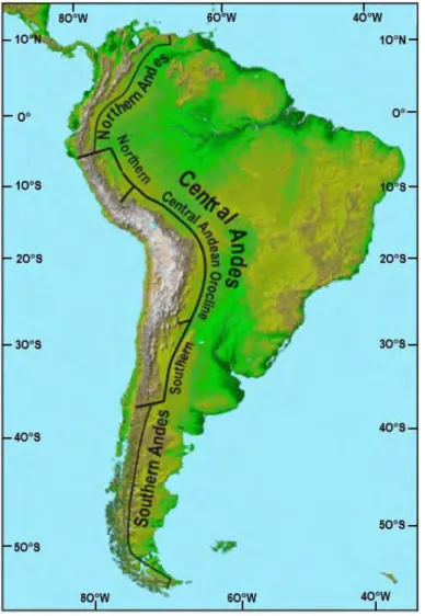
The Andean physiography has been divided into three latitudinal segments which differ from each other on width and elevation criteria (e.g. Sempere et al., 2002). Namely the northern Andes from 12°N to 4°S is constituted by the Ecuadorian, Columbian and Venezuelan range, the Central Andes 4°S-35°S in Peru, Bolivia and Chile, and the Southern Andes from ~4°S-35°S to ~55°S in Chile (Figure 2.4). The Central Andes can be subdivided itself into three parts: the northern segment from ~4°S to ~13°S mainly located in Peru, the so-called Central Andean Orocline between ~13°S and ~28°S including part of Peru and Chile in its western flank and finally the southern Central Andes from ~28°S to ~35°S located in Chile and Argentina.
Figure 2.4 ‒ Segmentation of the Andes at different latitudes, after Sempere et al. (2002).
2.1.3 Geology of northern Chile in the region of Antofagasta
In the Central Andean Orocline from 23°S to 28°S (Figure 2.4) the Chilean forearc can be divided from west to east into the Coastal Cordillera, the Central Depression, the Precordillera, the Western Cordillera and the Altiplano (Jordan et al., 1983; Borgel, 1983).
35
These units correspond to different lithologies, which are going to be described in the following. In northern Chile the Coastal Cordillera reaches up to ~1500 m.a.s.l. and is characterized by an abrupt cliff (e.g. Paskoff, 1977; Macharé and Ortlieb, 1992; Regard et al., 2010). The Central Depression is located between 1000 to 2000 m.a.s.l while the Precordillera, the western Cordillera and the Altiplano correspond to elevations between ~2500 and ~4000 m.a.s.l. (Figure 4.5).
I will first present lithology and then present the deformation and exhumation evidences identified in the Precordillera, which will be the focus of this work.
Figure 2.5 ‒ A. Morpho-structural in northern Chile B. Topographic profile of the forearc at 23°S, after Valero-Garcés et al. (1999).
2.1.3.1 Lithology
The northern Chilean geology in the region of Antofagasta reflects many geologic events associated with variations in the subduction dynamics.
36
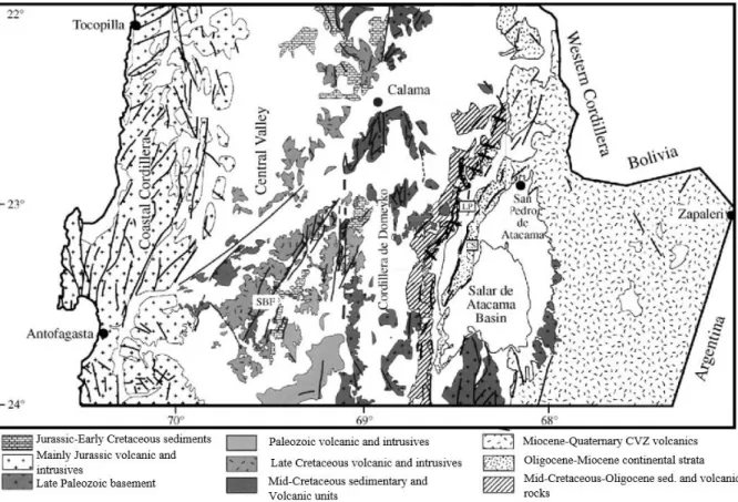
The geology is characterised by terranes accreted to the South American margin during the Paleozoic constituting the basement, old magmatic arcs and active magmatic arcs, wide Jurassic marine incursions, and finally Neogene continental sediments (Figure 2.6).
Figure 2.6 ‒ Geological map of the Antofagasta region between 22°S to 24°S., after Mpodozis et al., (2005). Volcanic units show the progressive migration of the volcanic arc toward the east from the Jurassic to present day (Figure 2.7), and form four large north-south oriented distinct ancient arcs (Scheuber et al., 1994). In the Coastal cordillera, the Jurassic arc corresponds to the broadly distributed La Negra volcanic formation. Huge plutonic gabbroic and granodioritic bodies intruded these volcanic deposits through NS and NW-SE sinistral strike-slip and normal faults in a context of intra-arc controlled by oblique subduction (e.g. Parada et al. 2007; Grocott and Taylor, 2002). In the Central Depression, Late Cretaceous plutons of andesitic and rhyolitic-dacitic nature correspond to migration of the magmatic arc towards the East. This period is characterised by a major plate reorganization and by a phase of shortening in the Andes (“Peruvian” phase, Charrier and Vincente 1972; Charrier et al., 2007; Charrier et al., 2009). A foreland basin developed to the east of the arc, in which the Purilactis formation deposited during the Late Cretaceous to Eocene and that is nowadays located in eastern border of the Salar de Atacama (e.g. Arriagada, 1999; Mpodozis et al., 1999).
In the Precordillera, called the Domeyko range in this region, Paleocene and Eocene intrusions and calderas testify of a new eastward migration of the arc during the Incaic phase.
Paleomagnetism shows that most of the bloc rotations occurred by that time and no major rotation is recognized after 25 Ma (Arriagada et al., 2000, 2003, 2008; Narea et al., 2015).
37
A notable volcanic gap occurred between 38 and 26 Ma, a quiescence interpreted as a flat slab period (Soler and Jimenez, 1993). No intrusions younger than 37 Ma have been observed around 23°S in the Precordillera, but ignimbrites of about 10 and 5 Ma in age have been recognized (Da Silva, 1989). Finally, the active arc is located in the Western Cordillera.
Figure 2.7 ‒ Migration of the magmatic arc to the east through time (Mpodozis and Cornejo, 2012 after Haschke et al., 2002), illustrated by volcanic rock ages vs longitude.
The deposit of Mesozoic marine and continental sediments in this region began in the Sinemurian to Kimmeridgian, in a context of back-arc extension. At that time, the arc was located in the Coastal Cordillera. The corresponding geological groups were called Quinchamale and Caracoles. The ~5000 m thick Bajocian to Kimmeridgian Caracoles group deposited on the eastern flank of the Jurassic back-arc basin is now found in the Pre-Cordillera, on the western flank of the Domeyko range (Figure 2.8).
During the Late Cretaceous and Early Cenozoic shortening phase, as indicated above, a foreland basin has developed to form the Purilactis sedimentological series, nowadays located in the Salar de Atacama western border. The base of this series is constituted of marine limestones, which argue for a contemporary rifting context.
Above, the continental terrigenous series is mainly composed of conglomerates and coarse sandstone with some volcanic intercalations (Muñoz et al., 2002; Mpodozis et al., 2005; Bascuñan et al., 2015).
38
There is no unanimity between scientists about the tectonic control on deposition of these sediments (see Charrier et al., 2010). Some authors argue for an extensional context (somehow related with opening of the Atlantic Ocean (Macellari et al.; 1991; Hartley et al., 1992 and Flint et al., 1993), whereas others assert that a first period of extension followed by a tectonic inversion in the Late Cretaceous, led to the eastward thrusting of the Pre-Cordillera over the Salar de Atacama basin (Figure 2.8) (Bascuñan et al., 2016; Mpodozis et al., 2005).
Sedimentation continued overlying the Purilactis group up to the Pliocene and probably Pleistocene, with the deposition of evaporites (e.g. Muñoz et al., 2002). In total, the Salar de Atacama infill reaches ~9000 m.
Figure 2.8 ‒ Schematic cross-section of northern Chile between 22°–23°S, showing basin and orogenic wedge evolution. The figure also shows a hypothetical eroded forearc (Bascuñan et al., 2015).
Between the Coastal Cordillera and the Salar de Atacama, Eocene-Oligo-Miocene gravel constitutes most of sedimentary cover. Their thickness reaches from several tens of meters to ~1000 m. Two basins were particularly well studied in this region, the Calama Basin, and the Centinela Basin. As the deposition time of these sediments encompass the period studied in this manuscript, (Eocene to present), I recall here the main units.
The Calama basin is located in the northern border of the studied region. It contains several hundred meters of sediments from the Eocene to Late Pliocene-Pleistocene with four different identified depo-centres (Jordan et al., 2015). There seems to be no agreement about the stratigraphic subdivision of this basin (Hartley and Evenstar, 2010 and Jordan et al., 2014). The most recent compilation of sedimentological data can be found in Jordan et al. (2014).
A simplified stratigraphy may include the Eocene Calama formation (conglomerates), the Oligocene Yalqui formation (sandstones and conglomerates), the Miocene El Loa group (ignimbrite, sediment breccias, sandstone) and the Plio-Pleistocene Opache and Chiu-Chiu formations (sandstones and limestone) (e.g. Blanco et al., 2003; May et al., 2005, Mpodozis et al., 2005; Jordan et al., 2014).
39
The Centinela basin records a similar time period as the Calama basin in a ~1000 m thick infill. It is mainly filled by alluvial deposits with few intercalated sandstones, limestones and paleosoils, with only two ash deposits at ~37 Ma and ~10 Ma (Figure 2.9). This makes the dating of the different formations difficult (Mora et al., 2004; Tapia et al., 2012; Oerter et al., 2016; Riquelme et al., 2017).
The lowest member of the Centinela basin is the Eocene Esperanza formation. Then comes the El Tesoro formation, up to 700 m thick. This formation hosts exotic copper and has been assigned to Oligocene. Eocene zircons present in these sediments indicate that porphyry copper of the Domeyko range were massively eroding at that time and provided the sediment filling the basin. The upper part of the infill is the Arrieros formation, a widely extended late Miocene gravel cover corresponding to a widening of the basin, interpreted by Riquelme et al. (2017), as a pedimentation stage, which appears consistent with new results presented in the following chapters. The ~10 Ma ignimbrite seals the present-day topography in many places, signing a sudden stop in the sedimentation. However, younger sediments testify of an ongoing, although very slow, sedimentation in valleys (Davis et al., 2014).
Figure 2.9 ‒ Centinela basin stratigraphy along a ~8 km latitudinal transect along with detrital Ar-Ar biotite age in red, U-Pb detrital zircon ages, in blue, cryptomelane age, in green and U-U-Pb zircon ages in black after Riquelme et al. (2017).
40
In the Calama and Centinela basins, both infills indicate an arid climate from the Eocene to hyper-arid current climate. These sediments reflect the uplift and erosion of the adjacent Domeyko range during the so-called Eocene Incaic phase, with depo-centers probably influenced by faulting. Then the Oligo-Miocene sedimentation area is widened in absence of significant creation of accommodation space (Riquelme et al., 2017).
2.1.3.2 Structural framework
In addition to the subduction thrust, two main fault systems have controlled the fore-arc deformation in the studied region since the Jurassic (Figure 2.10). These fault systems are roughly parallel to the subduction trench.
The westernmost fault system is the Atacama Fault System (AFS) whose activity started in the Early Jurassic probably with the initiation of the South American subduction and the beginning of the Andean Orogeny (Scheuber et al., 1994). It has been active during the Neogene (Riquelme et al., 2003) with some strike-slip and mainly vertical movements (e.g. Gonzalez et al., 2003; 2006).
Figure 2.10 ‒ Simplified structural geological map of northern Chile between 27°S-21°S, (Arriagada, 2003) with Atacama Fault System (AFS) and Domeyko Fault System (DFS).
41
The second notable fault system, to the east, is a strike-slip system called the Domeyko Fault System (DFS) occurring in the Precordillera. The DFS is also parallel to the coastal border which activity begun during the Eocene (Mpodozis et al., 1993). The DFS is of a particular interest for this PhD thesis because it controlled both the sedimentation in the Centinela basin and the exhumation of the studied porphyry-copper deposits.
Note that the region of Antofagasta seems to not correspond to the model by Armijo et al. (2015), arguing that the West Andean Thrust system (WAT) is the main fault system controlling the westward thrusting of all the Central Andes over the forearc. Although the WAT has been recognized for many years in many places along the Chilean (and Peruvian) Andes (Charrier et al., 2009), it seems absent in this region. Actually, the main deformation seems to have occurred in the Pre-Cordillera since the Late Cretaceous along strike-slip and east-vergent faults (e.g. Muñoz et al., 2002; Bascuñan et al., 2016).
2.1.3.3 Exhumation quantification
Several decades ago, the large deformation of the central and southern Andes was classified through three phases. That classification includes: Peruvian phase (inversion in the Late Cretaceous, Pfiffner and Gonzalez. 2013, Mora et al., 2010), Incaic phase (Eocene compressional phase) and Quechua phase (Miocene reactivation of Eocene faults), which were recognized in southern Peru phases. The ubiquity of these past deformations all over the Andes is still debated. Additionally, to the differentiated manifestation of these deformation phases along the Andes, there is also a debate about the duration of the phases. For example, concerning the Incaic Eocene phase, several studies point out very punctual deformations (Hammerschmitd et al., 1994) whereas other authors propose a long deformation phase (Maksaev and Zentilli, 1990, Jaillard et al., 1996).
To study the vertical deformation, structural analysis was carried out (Mpodozis et al., 1993) on one hand, and on the other hand rock path exhumation quantification of rock has been determined in some places through low-temperature thermochronology methods (specific details are described in the following chapters).
In the three last decades, thermochronology has been applied in the northern Atacama Desert (Figure 2.11), starting with Maksaev’s PhD thesis, 1990. Maksaev and Zentilli (1999)’s publication was the first to quantify the Precordillera exhumation and timing using the fission track on apatite method. The authors suggest that before 30 Ma, exhumation rates were about 200-100 m.My-1 and dropped to 50 m.My-1 after 30 Ma. A study of the major Chuquicamata copper ore deposit was published the same year (McInnes et al.,1999) showing the cooling history of the ore deposit. Then thermochronological data (U-Th)/He obtained on apatite and zircon from the coast to the western Cordillera at ~26°-27°S, were presented in 2007 in which the authors suggest different steps for the forearc exhumation (Nalpas et al., 2007), with younger ages moving to the east. This was confirmed by the dataset from Reiners et al. (2015) on at the forearc larger scale.
42
Even though significant works were performed, the studied objects were really local or very large scale (McInnes et al., 1999; Campos et al., 2009; Maksaev et al., 2010), mainly to constrain the cooling history of the porphyres. There is a lack of thermochronological study at the scale of mountain-plus-basin systems which appear necessary to better understand the formation of supergene copper ore deposit (McInnes et al., 2005). Furthermore, previous studies did not allow the paleo relief and its relation with the formation of supergene copper to be really defined.
Figure 2.11 ‒ Low-temperature thermochronologic study zone in the Atacama Desert from 28°S to 18°S (Maksaev et al., 1990; Andriessen et al., 1994; Reiners et al., 2015; McIness et al., 1999).
43
2.2 Climate of the Atacama Desert
2.2.1 Definition
The Atacama Desert, which extends from ~30°S in Chile to 10°S in Peru is the driest non-polar desert on the planet (New, 2002; McKay et al., 2003). As one can see in Figure 2.12, the rainfall distribution shows the transition between arid and Mediterranean climate at 30°S.
Present-day precipitations of this Desert, defined as hyper arid, are inferior to 20 mm.yr-1 (Houston, and Hartley, 2003) with areas of extreme hyperaridity where precipitations are inferior at <1 mm.yr-1 (Garreaud et al., 2009). The precipitation rate spatial variations in the Desert are mainly related to altitudes. The rare precipitation events are generally related to El Niño events.
Figure 2.12 ‒ Rainfalls rate in the Norther Chile, Atacama Desert, from ~15°S to 35°S (m.yr-1), (Strecker et al., 2007).
2.2.2 Why is northern Chile a desert?
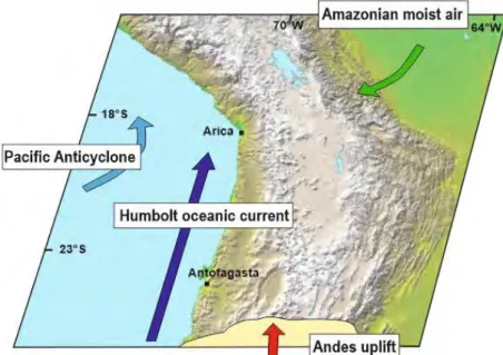
The different mechanisms suggested by Hare (1961) to explain the Atacama Desert formation are depicted in Figure 2.13. They are displayed together with precipitation rates and altitude in the forearc between Arica and Belen, near 18°S in northern Chile (Figure 2.14).
First of all, a strong control is exerted by the presence of the subtropical ridge which is a significant high atmospheric pressure belt at 30°S, as witnessed by the presence of major deserts (Namib Desert, Australian Desert…) on Earth.
44
The southern pacific anticyclone prevents moisture formation on the west coast of Chile and provides atmospheric stability. A second reason relies on the influence of the Humboldt oceanic cold current, which originates near the Antarctic since Drake’s passage.
This cold current refreshes the marine air mass and prohibits the generation of water vapour, and thus inhibits precipitation on the continent (Houston and Hartley, 2003). The third major mechanism is the elevation of the Andes forming a physical barrier to hotter and wetter air masses coming from the Amazonian basin. All the water driven southwards the Amazonian basin is dropped when air masses rise, condense and discharge on the Bolivian side of the Andes (Zhou and Lau, 1998; Vuille and Amman, 1997). This effect is also called the orographic rain shadow effect. Despite those hyper-arid conditions, rare and catastrophic rainfall events occur during El Niño and la Niña periods in the Atacama Desert (Ortlieb et al., 1994; McKay et al., 2003; Houston et al., 2006).
Figure 2.13 ‒ Possible mechanisms responsible for low precipitations in the Atacama Desert. DEM from http://photojournal.jpl.nasa.gov/jpeg.
Figure 2.14 ‒ Generalized latitudinal section of precipitation and elevation from 70 to 50°W based on Philip’s World Atlas Fullard and Darby (2001), Lizarazu et al., (1997), Dirección General de Aguas de Chile and Houston and Hartley (2003).
45
The potential coupling between the rising of the Andes and a major climate change has been invoked to explain the Late Miocene surface uplift of the Andes (e.g. Lamb and Davis, 2003). Furthermore, the Andes relief influence on the southern atmospheric circulation is thought to have controlled Andean erosion and morphology (Montgomery et al., 2001).
Yet, the causality or synchronicity between the uplift and the rain shadow effect is debated. (U-Th)/He geochronology on hematite to recover the incision timing in northern Chile suggest that aridity is posterior to the main Andean uprising episode (Cooper et al., 2016). Numerical modelling of global ocean circulation concludes that decreasing the elevation of the Andes does not increase the rainfall in the Atacama region (Garreaud et al., 2010). This result suggests that the Andean uplift was not the driver of Atacama hyper-aridity, which should be rather associated with a strengthening of the Humbold current (Garreaud et al., 2010)
2.2.3 Since when?
To date the onset of aridity, a panel of different approaches exist such as sedimentological study, soil analysis, surface exposure dating, copper supergene mineralization and stable isotope analysis on sediments. All these methods have been applied with a large panel of results and ages (Figure 2.15).
Figure 2.15 ‒ Summary of aridity ages proposed for the Atacama Desert, the tool used to obtain the age and references. Variation in precipitation rates >100 mm.y-1 in dark grey and <100 mm.y-1 in light grey.