518118-1 GABARDINE
Groundwater artificial recharge based on alternative sources of water: advanced integrated technologies and management
Instrument
Thematic Priority: Global change and Ecosystems
DL 43
Stress factors and associated physically based criteria and conclusions on the
directions to be followed for developing a physically based vulnerability
assessment method
Due date of deliverable: April 30, 2006 Actual submission date: October 15, 2006
Start date of project: November 1st, 2005 Duration: 3 years Authors: Nicolas GARDIN1, Piotr WOJDA1, Serge BROUYERE1,2*
*Corresponding author: Serge.Brouyere@ulg.ac.be
Tel.: +32 4 366 23 77 Fax: +32 44 366 95 20
Organisation name of lead contractor for this deliverable: University of Liège, Hydrogeology & Environmental Geology1 and Aquapôle2
Revision Nb2
Project co-funded by the European Commission within the Sixth Framework Programme (2002-2006)
Dissemination Level
PU Public X
PP Restricted to other programme participants (including the Commission Services) RE Restricted to a group specified by the consortium (including the Commission Services) CO Confidential, only for members of the consortium (including the Commission Services)
Generic and specific outcomes for the GABARDINE project
The specific results and outcomes of this deliverable is the proposition of a methodological framework for groundwater vulnerability assessment to any kind of stress factors, from a physically-based point of view. This methodology is in addition compatible with the well-known EU DPSIR framework for analysis from a physical and socio-economical perspective, environmental problems.
From a more generic perspective, this deliverable provides a very convenient and rigorous framework for integrating the various research components developed within the project, into a decision support system, integrating environmental problems, data, processes and models, and socio-economical aspects.
Table of content
1 INTRODUCTION... 5
2 IDENTIFICATION OF STRESS FACTORS APPLIED TO ARTIFICIALLY RECHARGED GROUNDWATER ... 7
2.1 THE DPSIR CONCEPT... 7
2.2 DESCRIPTION OF THE D-P-S-I CHAIN AS APPLIED TO THE GROUNDWATER RESOURCE... 8
2.2.1 IDENTIFICATION OF RELATIONSHIPS BETWEEN DRIVING FORCES AND PRESSURES... 9
2.2.2 IDENTIFICATION OF RELATIONSHIPS BETWEEN PRESSURES AND STATES... 12
2.2.3 IDENTIFICATION OF RELATIONSHIPS BETWEEN STATES AND IMPACTS... 16
2.3 GROUNDWATER ARTIFICIAL RECHARGE AND THE DPSIR CHAIN... 18
3 ARTIFICIALLY RECHARGED GROUNDWATER VULNERABILITY ASSESSMENT ... 21
3.1 TRADITIONAL CONCEPTS OF GROUNDWATER VULNERABILITY ASSESSMENT... 21
3.2 GENERALIZED GROUNDWATER VULNERABILITY ASSESSMENT AND THE DPSIR CHAIN... 23
3.2.1 GENERALIZATION OF THE CONCEPT OF GROUNDWATER VULNERABILITY... 23
3.2.2 GROUNDWATER STATE SENSITIVITY COEFFICIENTS... 25
3.2.3 FIRST PROPOSITIONS FOR ASSOCIATED PHYSICAL CRITERIA AND INDICATORS OF CHANGES IN THE P-S-I CHAIN... 26
3.3 GROUNDWATER VULNERABILITY AND THE SPECIFICITY OF ARTIFICIAL RECHARGE... 37
4 CONCLUSIONS AND PERSPECTIVES... 39
A physically-based, generalized framework for artificially
recharged groundwater vulnerability assessment
Summary
This deliverable provides the elements for the development of a physically-based groundwater vulnerability assessment method to various kinds of stress factors affecting the groundwater resource, into consideration the particularity of the artificial recharge process.
This methodology has been made compliant with the DPSIR framework developed for analyzing from a common physical and socio-economical point of view environmental problems. In a first step, the Driver – Pressure – State – Impact causal chain is explained and detailed for the context of artificially recharged groundwater in (semi-)arid environment of the Mediterranean border. In particular, an innovative presentation of the groundwater state is proposed consisting in classifying its various subcomponents into: (1) groundwater state upstream factors, i.e. the physical elements directly in connection with the pressures), (2) groundwater state variables and (3) groundwater state downstream factors, i.e. the physical elements that are directly in connection with the impacts.
Based on this analysis, a general methodology is proposed for estimating groundwater resource sensitivity coefficients and an associated groundwater vulnerability matrix. Physically-based criteria and indicators of changes are proposed for the various subcomponents of the groundwater state as affected by pressures. In this conceptual framework, the specificity of artificial recharge, acting both as a pressure and a response, is discussed and first advanced concepts are proposed for considering this dual behaviour in the groundwater vulnerability analysis.
Conclusions are drawn on the directions to be followed for developing an efficient groundwater vulnerability assessment technique based on these theoretical concepts and on using this methodology as a framework for decision support in relation with artificial recharge technologies.
1 Introduction
Groundwater is the most important liquid freshwater resource in the world. This resource is relatively easy to access because it is present everywhere in the globe, generally with a good quality thanks to the natural protection offered by soil layers against contaminations occurring at the land surface. These characteristics mean that groundwater has functions of fundamental importance to human life, ecosystem preservation and economic development.
Development of human activities poses a treat to these functions because they represent the first elements of causal links which lead to quantity and quality stresses on groundwater reservoirs, such as excessive groundwater exploitation which leads to falling of groundwater levels, inappropriate or uncontrolled activities which leads to contamination of underlying aquifers, major changes in land use which lead to surface waterproofing and decrease of groundwater recharge... Moreover, human activities are also the responsible of climate changes which will probably strongly disturb the hydrological cycle and groundwater resources (e.g.Arnell, 1998, IPCC, 2001, Arnell, 2002).
In this context, artificial recharge can be considered as a solution to prevent or to remedy to the consequences of several of these stress factors. Indeed, artificial recharge is usually used to restore groundwater levels, to provide a barrier for seawater intrusion in coastal aquifers and to perform seasonal and long term storage of water in aquifers. However, artificial recharge may also constitute a stress factor for the groundwater resource through the changes operated in the aquifer system functioning, such as rise in groundwater levels, or by inducing porosity clogging, groundwater contamination by organic compounds, pathogenic bacteria and viruses, chemical reactions with groundwater chemical compounds which can modify the reservoir properties by rock dissolution, precipitation…
The importance of groundwater damages will depend on the intensity of the stress factors and on the sensibility of the groundwater resource to these stress factors. The sensibility of the groundwater resource, usually called groundwater vulnerability, depends on the system properties and on the possible interactions between the groundwater system and the stress factors.
In hydrogeology, the concept of groundwater vulnerability is often used to describe the susceptibility of groundwater to contamination usually occurring at the surface. In coastal areas, groundwater vulnerability may also concern sea water intrusions. The present work proposes developments and further steps in a way to generalize the concept of groundwater vulnerability by
including any kind of stress factors which affect groundwater resources.
Prior to the development of a groundwater vulnerability assessment method, it is necessary to identify which are the stress factors that will be considered and which are the affected characteristics of the groundwater resource. The DPSIR approach will be used as a general framework to analyse the relationships between stress factors, groundwater characteristics and resulting possible impacts. The generalized groundwater vulnerability assessment concepts will thus be organized and described in a way that is fully compatible with the DPSIR framework, as used as a decision support protocol in the GABARDINE project. This analysis provides a description of the physical loop of the DPSIR framework in the form of a causal chain of physical factors and components that relate the upstream pressures to the downstream impacts, with the groundwater resource and its various components acting as transmitters in the chain.
2 Identification of stress factors applied to artificially
recharged groundwater
2.1 The DPSIR concept
The general idea is to develop a methodological and applied framework for the evaluation and quantification of the “global” vulnerability of the groundwater resource considering, in a unifying analysis, the various acting stress factors and the possible degradation they can induce. This methodology should also deal with the possible effect of artificial recharge. To reach that objective, a methodological framework is required that allows analysing the environmental context and combining the various elements that make the groundwater resource more or less vulnerable in a general sense. Recently, Wojda et al. (2006) have issued a working document to the partners of the GABARDINE project which presents the DPSIR concept and its application to the context of groundwater artificial recharge. As will be shown later, the Pressure – State – Impact causal chain that composes the essential element of the DPSIR makes it a very convenient methodological framework for developing a generalized groundwater vulnerability assessment methodology.
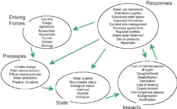
To facilitate the reading of the present deliverable, the following paragraphs synthesize the main elements of the description of the DPSIR framework as adopted in the GABARDINE project. The DPSIR concept has been developed for describing interactions between society and the environment (Kristensen, 2004) starting from the assumption that there is a causal chain (Figure 1) beginning with social and economic developments linked to anthropogenic activities, such as agriculture and industry (Drivers), which exert Pressures on the State of the environment, such as excessive use of resources, change in land use and emissions to air, water and soil. The state of the environment is the combination of the physical, chemical and biological conditions as modified and degraded by the pressures. This results in Impacts which are the consequences of changes in the physical, chemical and biological states of the environment which alter the functioning of ecosystems, their life-supporting abilities and ultimately human health and socio-economical performance of the society. These undesired impacts require Responses from human society to improve the state of the environment. Responses can affect any part of the causal chain.
Figure 1 - DPSIR framework as applied to water resources (from Kristensen 2004)
The strategies developed by the European Commission for the implementation of the Water Framework Directive have identified the DPSIR framework as a convenient way to identify stress factors and there effects on groundwater (EC, 2003). Once the driving forces have been listed, the resulting stress factors (pressures in the DPSIR framework) can be clearly defined as well as their consequences on the groundwater state. This is the purpose of the following sections.
2.2 Description of the D-P-S-I chain as applied to the groundwater
resource
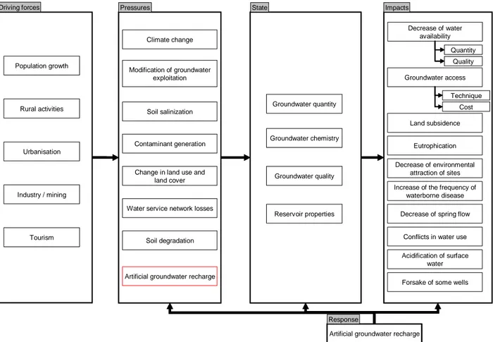
Figure 2 is a general presentation of the DPSIR framework focusing on groundwater resources. In the next chapters, the relations between driving forces and pressures, pressures and state, and finally between state and impacts will be presented in details. Artificial recharge will also be discussed as a possible response to prevent groundwater resource degradation or to restore its state, as well as a possible pressure on the groundwater system.
Population growth Rural activities Urbanisation Industry / mining Tourism Modification of groundwater exploitation Contaminant generation Soil salinization
Change in land use and land cover
Soil degradation Water service network losses
Climate change
Driving forces Pressures State Impacts
Land subsidence Decrease of environmental
attraction of sites Increase of the frequency of
waterborne disease Decrease of spring flow
Conflicts in water use Acidification of surface
water Forsake of some wells
Decrease of water availability
Artificial groundwater recharge
Quantity Quality Technique Cost Groundwater access Eutrophication
Artificial groundwater recharge Response
Groundwater quantity Groundwater chemistry
Groundwater quality Reservoir properties
Figure 2 - The DPSIR framework for the groundwater resource in the GABARDINE project.
2.2.1 Identification of relationships between Driving forces and Pressures
2.2.1.1 Population growth
Population growth is often considered as the root driving force of environmental problems (Morris et al., 2003) because it participates to the emergence of other driving forces such as urbanisation, tourism, industry etc.
Pressures on groundwater which are resulting from population growth and "improvements" in living standards consist in increase in groundwater exploitation to meet population needs and in increase of waste generation and contamination of underlying aquifers.
2.2.1.2 Urbanisation
From an environmental point of view, the urbanisation process is characterised by three major trends (Morris, et al., 2003): considerable modifications of the local environment (land sealing, infrastructure such as water service networks,…), mobilisation of natural resources in a much more extended area than the boundaries of the city and increase in waste generation. Resulting pressures can be grouped into four categories: changes in land use, water service network
losses, modification of groundwater exploitation and generation of contaminants.
Changes in land use can lead to a reduction of natural infiltration by changes in natural drainage due to land sealing. Water service network losses lead to an increase of the infiltration to the groundwater resource. The result of these two pressures is a modification of recharge patterns (Lerner, 2002, Morris, et al., 2003) The net effect for many cities is a rise in the total volume of recharge.
Urbanisation also comes with an increase of water demand for domestic, commercial and industrial uses and with major changes in the way local aquifers are exploited (Foster et al., 1998). In the early settlement phase, water supply is obtained from shallow urban wells and boreholes. When the town becomes a city, water levels decrease because of further increase in water demand, which requires a deepening of wells. In the next stages of the city development, groundwater resources below the city often become overexploited and polluted. Wells located in the city are then progressively abandoned and groundwater exploitation is moved to peri-urban well fields. This can be accompanied by a rise in groundwater levels in the city due to the increase of the net recharge resulting from the water service network leakage (Morris, et al., 2003).
Finally, urbanisation also exerts pressures that directly lead to the generation of contaminants (Lerner, 2003), from leaking sewage systems and from solid wastes. Urban areas also concentrate pressures such as hydrocarbon emissions by vehicles, upkeep of the open spaces which may need the use of nutrients and pesticides, winter maintenance of roads and highways (de-icing using salts). Hydrocarbon emissions by vehicles also contribute to climate changes which will probably greatly affect groundwater resources.
2.2.1.3 Rural activities
The intensification of agricultural activities is the source of both direct and indirect pressures to groundwater resources.
Irrigation is the most important freshwater consuming activity in the world. Furthermore, irrigation can lead to soil salinisation problems that occur when water is applied in excess to the cultivated land. Even if a part of the irrigation water is used by vegetals, the remaining quantity can percolate or evaporate, the evaporation process leading to excessive concentrations of salts in the soils.
agriculture represent other pressures on groundwater resources.
Agriculture may also result in indirect pressures on groundwater resource through soil degradation, changes in land use and land cover, particularly by inducing changes in soil properties by ploughing and sowing. If these practices are performed without caution, soil erosion and runoff can be exacerbated. In some part of the world, agriculture being the main source of income for a large part of the population, there is a trend to increase the cultivated surfaces to the detriment of the other kind of soil occupations and particularly forestry. Modification in land use, land cover and soil degradation both have the same consequences and effects on infiltration, evapotranspiration, runoff and finally on groundwater recharge patterns. Finally, modification of vegetation can also exert pressures by changing the contaminant uptake capacity.
2.2.1.4 Industrial activities, quarry and mining activities.
Industrial processes often use and produce large quantities of raw materials and dangerous and concentrated effluents and wastes, containing heavy metals, organic solvents, hydrocarbons… Production and storage areas may represent contaminant sources for groundwater. Industrial activities are also one of the main causes of the climate changes which will probably affect the groundwater resource in various ways.
Quarry and mining activities often make it necessary to perform dewatering pumping which may exert locally considerable pressures on groundwater. Groundwater quality may also be accidentally affected by some products like fuel stored in the extraction area. After mine closure, pumping operations are stopped and groundwater rebound develops in the dewatered layers. This phenomenon is often accompanied by adverse effects such as water inrushes, land stability problems and acid mine drainage due to the fact that water coming out of the mined system is often characterised by a very low pH and can lead to a degradation of surface water and adjacent groundwater bodies.
2.2.1.5 Tourism
Most of the studied zones in the GABARDINE project are located in regions which attract more and more tourism, which causes pressures on groundwater resource similar to "Population" and "Urbanisation", i.e. increase in groundwater exploitation and waste generation. However, "Population" and "Urbanisation" exert constant pressures on groundwater resource, while pressures resulting from the tourism activities are highly variable during the year, according to the seasonality of this kind of activity. At the same time, pressures associated with tourist activities may be very
damageable because they reach their maximum during the summer season, when hydrological conditions are most critical.
2.2.1.6 Synthesis of identified pressures
The previous sections have identified five driving forces possibly affecting the groundwater system: population growth, urbanisation, rural activities, industrial, quarry and mining activities and tourism.
Pressures on the groundwater resource resulting from these driving forces can be summarized as follows:
- Climate changes which are and will be the consequences of contaminant emissions in the air
- Changes in groundwater exploitation which is mostly the consequence of changes in water demand because of socio-economical development and population growth
- Soil salinisation which is the consequence of increased irrigation practices
- Contaminant generation which comes from various sources (both point and diffuse)
- Changes in land use and land cover mostly related to agricultural practices and urbanisation
- Losses in water services networks which are associated with population growth and urbanisation processes
- Soil degradation mostly associated with rural activities
- Artificial recharge in itself, as discussed further in more details (see section 2.3)
2.2.2 Identification of relationships between Pressures and States
This section details how pressures identified here above do affect the groundwater resource identified as the ‘state’ of the DPSIR chain.
2.2.2.1 Climate changes
Expected climate changes can be have both direct and indirect effects on groundwater resources. Expected changes in precipitation and evaporation patterns will directly result in modifications of groundwater recharge and, indirectly, on groundwater levels (Brouyère et al., 2004). It can also be expected that changes will be observed in chemical processes occurring in the aquifer, such as changes in chemical weathering, in microbial activity etc. Finally, climate change may also affect the reservoir properties. For example, in karstic systems, dissolution phenomena are strongly dependant on climatic factors (Goldscheider, unpublished).
It can also be expected that indirect effects will be observed, through the possible impact of climate changes on other driving forces affecting the groundwater resource, e.g. through enhanced soil degradation, changes in vegetation and land use (Loaiciga et al., 1996, Eheart and Tornil, 1999, Loaiciga et al., 2000, Feddema and Freire, 2001). These will possibly affect both groundwater quantity and quality (e.g. Arnell, 1998). Modification in soil properties will result in changes in runoff and infiltration capacities, and consequently in groundwater recharge. Modifications in vegetation will result in modifications of contaminant uptake capacities by vegetation so in positive or negative changes in contaminant leaching. Changes in air temperature, evapotranspiration and precipitation will also lead to modifications in groundwater demand (more irrigation required…) so in groundwater exploitation.
2.2.2.2 Changes in groundwater exploitation
The direct consequence of a change in groundwater exploitation is a global or local change in the groundwater quantity stored in the aquifer, the associated consequences being very different. If the modification concerns the whole groundwater resource, i.e., if it is of the order of the renewal groundwater volume, the groundwater resource is affected globally, e.g. groundwater overexploitation. The modification may also have still dramatic but more limited in space consequences, such as local drawdowns in groundwater levels, in which case the groundwater resource is affected locally.
Reductions in groundwater levels have direct consequences such as reduction in base flow and spring flow rates, drainage of wetlands… They also have indirect consequences through modifications in flow patterns and inflows of water from adjacent water bodies (superficial aquifers, river, sea…), resulting in:
will cause a deterioration of groundwater quality; saline intrusion is a particular case of this issue: in coastal regions, a reduction in groundwater levels invariably produces inflow of salt water in the groundwater reservoir,
- changes in physicochemical properties of groundwater due to mixing of waters of possible different compositions,
- changes in aquifer properties through dissolution of the bed rock matrix, reduction of porosity by precipitation reactions,…
2.2.2.3 Soil salinisation
As stated previously, salts accumulated in soils because of unsuited irrigation practices can be dissolved by excess irrigation water and percolate downwards, causing an increase in salt concentrations in groundwater, thus degradation of groundwater quality.
2.2.2.4 Contaminant generation
As described before, contaminants may be generated by a wide range of pollution sources (agriculture, industrial activities, socio-economical activities…) which can be classified as either point sources (polluting activities concentrated over a small area) or diffuse sources (polluting activities spread over a large area). Some pollution sources, such as leaking sewer pipes, can also be considered as linear pollution sources.
Contaminant generation mainly leads to degradation of groundwater quality. However it can also affect physicochemical parameters of the groundwater resource by modifying the acidity, the conductivity or the global composition of groundwater.
2.2.2.5 Changes in land use and land cover
Changes in land use and land cover have two effects on groundwater resources. First, they may affect groundwater quantity: changes in land use cause changes in evaporation patterns, in runoff and infiltration soil capacity which lead to modification of groundwater recharge. Secondly, land cover changes may also affect groundwater quality through modifications of the contaminant uptake capacity of vegetation.
2.2.2.6 Water service network losses
Water service network losses mainly cause increases in water quantity present in the reservoir. However, this pressure can also affect the groundwater quality. Indeed, an increase in groundwater quantity lead to an increase of groundwater levels and consequently to a reduction of the unsaturated zone. Because the unsaturated zone acts as a protective layer for the aquifer, any reduction of its thickness leads to increased groundwater vulnerability and groundwater contamination risk.
2.2.2.7 Soil degradation
The soil degradation may lead to reduction in its water holding capacity, to increase of runoff during wet periods and consequently to reduction of infiltration capacity and groundwater recharge. However, this may sometimes be offset by the possible concomitant degradation of vegetation which leads to reduction in evapotranspiration.
2.2.2.8 Synthesis on affected groundwater state variables
Based on the pressure-state analysis, it appears that, from a general point of view, the alteration of the groundwater ‘state’ can be characterised using four main ‘concepts’ or ‘state variables’: groundwater quantity, groundwater quality, groundwater physico-chemical status and reservoir properties.
Groundwater quantity relates to the volume of water present in the aquifer reservoir. From the point of view of sustainable management of the groundwater resource, the groundwater reservoir has to be studied at the scale of the overall aquifer or the hydrogeological basin and the most suitable representation of groundwater quantity is simply the volume of water present in the aquifer, a distinction being necessary between the total volume and the renewable volume of water in the reservoir or even better the sustainable volume of water in the reservoir. Changes in groundwater quantity can also have local scale consequences related to reductions in groundwater levels, such as reduction of groundwater access, reduction of base flow to rivers and springs, land subsidence, degradation of wetlands…). It is thus suggested to consider the groundwater quantity state at two levels, using two representative variables: at global scale with associated groundwater volume and/or safe (sustainable) yield and, at local scale, with associated groundwater levels.
Groundwater quality reflects any change in groundwater composition related to external sources of contaminants mostly generated directly or indirectly by human activities. As mentioned
before, it will be necessary to make a clear distinction between point and diffuse sources of contamination because these two categories of contaminant distribution in space require very different approaches for solving or at least for mitigating their impacts and consequences.
Groundwater physico-chemical status reflects the “natural” composition of groundwater, strongly correlated to the composition of the underground geological formation and to the hydrogeological and hydrological context (neighbouring water bodies etc). It can be reflected by some physico-chemical properties of groundwater (pH, conductivity, redox potential, temperature…).
Reservoir properties include the hydrogeological properties of the aquifer, particularly porosity (water storage capacity) and hydraulic conductivity (groundwater flowing capacity).
2.2.3 Identification of relationships between States and Impacts
Modifications in the groundwater system may have important effects (impacts) on human society, such as availability of drinking water, public health, economy and on the environment (ecosystems, natural resources…). The list of these impacts may be considerable because water is a vital resource. In the following section, the most important impacts are presented.
2.2.3.1 Reduction in water availability
One of the main impacts common to all the state parameters is the modification of water availability, also called groundwater depletion (Konikow and Kendy, 2005) which generally lead to conflicts in water use. Indeed, a reduction in groundwater quantity will lead to an associated reduction in renewable water resource thus in water availability for the various uses of the resource.
Reduction in water availability may also be due to a degradation of groundwater quality or to a modification of the groundwater physico-chemical composition which make it inappropriate with respect to norms and standards associated to its various uses (drinking water,…).
Changes in reservoir properties may also affect the ease with which groundwater can be exploited and the volume of water which can be stored in the reservoir. A modification of these properties will thus lead to a modification of groundwater availability.
2.2.3.2 Increased costs for groundwater access.
increase of pumping costs and to the surrender of the shallowest wells. Although groundwater may still be present, its exploitation may require more financial and technical resources that are not always available.
In a similar way, degradation of groundwater quality (e.g. seawater intrusion) requires costly treatments prior to its usage, which restrict its exploitation to the best equipped users.
Modifications in reservoir properties, such as the aquifer permeability, will reduce the efficiency of water catchments systems and an increase in exploitation cost.
2.2.3.3 Decrease of spring flows and the river base flows
The reduction of the groundwater quantity and groundwater levels inevitably lead to a decrease in spring flows and river base flow, with possible consequences on human activities and aquatic ecosystems dependent on surface waters downstream (e.g. Hayashi and Rosenberry, 2002), more particularly during the dry season (summer) when rivers and streams are at their lowest levels (recession period).
2.2.3.4 Impacts on ecosystems
Decreases in groundwater levels may also cause drastic reductions of wetland areas while the feeding of surface water by contaminated groundwater may lead to degradation of fauna and flora associated to these particular sites (Hayashi and Rosenberry, 2002). Such perturbations may also have indirect impacts on specific activities such as tourism.
2.2.3.5 Eutrophication
Modifications in groundwater quality, mainly by leaching of agricultural nutrients (nitrates, phosphates), may lead to the eutrophication of the surface water fed through groundwater discharge.
2.2.3.6 Waterborne diseases
Degradation of groundwater quality and physico-chemical properties may result in a situation where quality standards (drinking water, bathing water…) are not respected anymore. If such water is consumed or used (because it is the only source of water), there is an important probability that the frequency of waterborne disease will increase.
2.2.3.7 Land subsidence
Groundwater pumping has the effect of decreasing pore water pressure and thus increasing the effective stress in strata overlying of the aquifer. When the increase in effective stress is greater than a critical value (preconsolidation stress), sediment compaction becomes irrecoverable and results in the formation of a depression in the topographic surface which may be harmful for buildings, the irrigation systems…
2.3 Groundwater artificial recharge and the DPSIR chain
Artificial recharge has been identified as a possible response to various problems related to water resources management, for example to prevent or to remedy to adverse consequences resulting from pressures like saltwater intrusion, reduction in groundwater availability, decrease in groundwater levels, degradation of groundwater quality… As a response, artificial recharge thus acts as a positive pressure on the groundwater state, through restoration of degraded conditions.
However, artificial recharge also influences directly the groundwater state parameters (quantity, quality, physico-chemical composition and reservoir properties). One can identify various changes in the state directly or indirectly resulting from the artificial recharge process, such as clogging phenomena, transport of organic compounds, pathogenic bacteria and viruses, inorganic chemical reactions in the unsaturated and saturated zone, changes in groundwater levels… Doing so, artificial recharge can also be considered as a negative pressure on the groundwater resource.
Identifying artificial recharge as both a pressure and a response in the present DPSIR chain makes the studied system more complex and non-linear. This will have consequences in terms of DSS structuring and in terms of groundwater vulnerability to stress factors. In other words, one of the elements to answer the question “is artificial recharge a valuable option?” is to calculate if the balance between the positive and negative pressures artificial recharge introduces on the groundwater state is sufficiently beneficial in the given context. The others are the technical and economical feasibility of the artificial recharge system and the availability of alternative sources of water for the recharge.
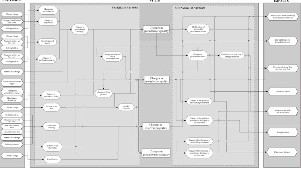
Based on all the D-P-S analysis presented here above and on the considerations relative to the influence of artificial recharge in the DPSIR chain, one can propose a causal chain from drivers to impacts (at least the most relevant relationships), passing through pressures and state (Figure 3). In this diagram, the state is further “split” into “state upstream factors”, i.e. physical components of
groundwater quantity, groundwater quality, groundwater physico-chemistry and reservoir properties and “state downstream factors”, i.e. physical components of the state that directly lead to the impacts (reduction in base flow, in groundwater levels…). Doing so allows one to develop a conceptual model of the groundwater resource that combines on the one hand the DPSIR methodology and a systems approach. The connections represent causal links between the different elements of the diagram. The dashed connectors indicate loop-back relationships between various components of the P-S-I chain. The way the various boxes are interconnected is surely not exhaustive and unique. It just reflects the main, logical, causal links that can be generally identified. However, the causal chain and diagram should be re-evaluated each time, case by case depending on the conditions and problems identified in the study site.
3 Artificially recharged groundwater vulnerability assessment
Based on the detailed analysis and description of the DPSIR causal chain as applied to artificially recharged groundwater presented in the previous chapter, this section will describe how it is proposed to extend the “traditional” concepts of groundwater vulnerability to any kind of stress factors and to integrate these new concepts in the DPSIR framework. The generalized concept of groundwater vulnerability will reflect the "sensitivity" of groundwater state variables to the pressures. From a practical point of view, it will be used as a “pressure to impacts transmitter” in the DPSIR causal chain. As will be discussed later, this concept will be also useful as a framework for evaluating the efficiency of artificial as a response to groundwater management issues.
In a first step, this section provides a brief description of “traditional” groundwater vulnerability concepts and more recent physically-based approaches. Then, first guidelines are proposed for the generalization of the concept of vulnerability to any kind of stress factors and for associated physical criteria useful for quantifying the vulnerability factors. Finally, some advanced DPSIR concepts suited to the specificity of artificially recharged groundwater resource management are introduced.
3.1 Traditional concepts of groundwater vulnerability assessment
The concept of groundwater vulnerability or groundwater susceptibility to pollution is often considered to estimate the natural protective capacity of the underground to contaminations occurring at the land surface (e.g. Albinet and Margat, 1970, National_Research_Council, 1993, Tripet et al., 1997, Doerfliger et al., 1999, Focazio et al., 2002) more recently to evaluate the vulnerability of water and groundwater resources to sea water intrusion or to climate changes (e.g. Lane et al., 1999, Rangel-Medina et al., 2004, Lobo Ferreira et al., 2005).
Numerous groundwater vulnerability and risk mapping techniques have been developed taking into consideration a variable number of factors such as depth to groundwater, hydraulic conductivity, porosity, and soil type, which are likely to increase or decrease the risk of groundwater contamination (Aller et al., 1987, Civita and De Maio, 1997, Doerfliger, et al., 1999). The most common techniques (e.g. DRASTIC, EPIK, SINTACS…) are based on the calculation of an index expressing the protective effect of underground formations overlying the groundwater resource. The various factors considered are mapped in the groundwater basin and overlaid using GIS applications to produce groundwater vulnerability maps. Such maps can then be combined with
information on potential contamination sources and associated risks in order to produce groundwater contamination risk maps that can be useful in land use planning etc.
Such methods are relatively easy to implement and they usually require little data. However, they are strongly empirical and they produce results that can be unreliable, very difficult to validate and to interpret and of very limited practical use (Gogu et al., 2003). The limitations of these methods are essentially related to of the fact that they rely on a “qualitative” and fuzzy definition of groundwater vulnerability, as opposed to a definition based on a quantitative description of contaminant migration (Brouyère et al., 2001, Popescu et al., 2004),.
Recently, the COST 620 European Expert group has adopted a common approach for assessing and mapping groundwater vulnerability (Daly et al., 2002, Zwahlen, 2003). The European approach is based on the “Origin – Pathway - Target” model, with particular attention paid to carbonate and karstic aquifers. The “Origin” is the assumed place of release of contaminant; the “Pathway” is the flow path of contaminant from its origin, through the system, to the point that has to be protected. The “Target” is the groundwater that has to be protected. The COST 620 expert group also proposed to make a distinction between groundwater resource vulnerability, concerning the groundwater resource as a whole, and groundwater source vulnerability, focusing on discharge points such as springs and pumping wells. For resource vulnerability, the contaminant pathway consists of the downward passage through the layers overlying aquifer; for source vulnerability it also includes the lateral passage in the aquifer.
In this framework, (Brouyère, et al., 2001) have proposed and discussed in details a physically-based point of view and definition of the concept of vulnerability, based on three factors describing a pollution event. This general framework is applicable to both source and resource vulnerability assessment and it produces clear, easily understandable and useful results in the form of vulnerability ‘thematic’ maps. It thus provides a very general groundwater protection methodology that combines prevention and natural protection aspects. These concepts have been considered for developing a physically-based groundwater vulnerability assessment and mapping technique for groundwater catchments and a first application was performed on the Néblon limestone basin in the Walloon Region of Belgium (Popescu, et al., 2004). This methodology has the further advantage to consider the possible impact of runoff conditions occurring at the land surface and possibly leading to lateral contamination of groundwater through downstream preferential infiltration features such as sinkholes etc.
the ultimate advantage over empirical methods that the results are expressed in terms of physical criteria (e.g.: contaminant travel time, maximum concentration at the target…), which make it very compatible with the DPSIR framework and concepts by using these criteria as indicators, in other words as “pressure to impact transmitters”. Classical approaches such as DRASTIC are not very suited to the DPSIR framework as they just produce “colour maps” which cannot be easily valorised in terms of quantifying the importance of an impact given the importance of a pressure.
3.2 Generalized groundwater vulnerability assessment and the DPSIR
chain
The DPSIR framework is useful in describing the relationships between the origins and consequences of environmental problems, but in order to evaluate the importance of the relation between two elements of the causal chain, it is necessary to simplify the factors identified in the DPSIR framework and to represent them by a parameter which can be easily estimated or measured. This is the role of environmental indicators (EEA, 2003).
In the DPSIR literature, the concept of vulnerability appears frequently but still based on relatively fuzzy definitions and most often in the more general sense of “environmental vulnerability”. Apparently, there has not been yet any detailed and systematic discussion and proposition on how to integrate the concept of groundwater vulnerability in the DPSIR framework, even less considering a physically-based groundwater vulnerability assessment point of view.
In the following section, a general framework is proposed to extend the physically-based groundwater vulnerability assessment approach proposed by (Brouyère, et al., 2001) and (Popescu,
et al., 2004) to any kind of stress factors (such as those identified previously) in a way that allows
easy integration of these concepts in the physical component of the DPSIR chain as applied to groundwater resources and considering the specificity of artificial recharge.
3.2.1 Generalization of the concept of groundwater vulnerability
In its original form, the concept of groundwater vulnerability reflects the natural mechanisms and processes that make the aquifer more or less sensitive to any kind of contamination.
In particular, intrinsic vulnerability reflects the capacity of the aquifer to reduce naturally any type of pollution of any kind of contaminant and whatever its quantity, input function and chemical properties.
Specific vulnerability takes into account the “results” of intrinsic vulnerability assessment, to which the effects of contaminant chemical behaviour in the underground are added. In other words, intrinsic and specific vulnerability reflect the relative importance at the target (i.e. the groundwater resource in its whole for resource vulnerability or any abstraction point for source vulnerability) of a contaminant released at the “origin”, i.e. usually the land surface. The definition of the pollution scenario (contaminant mass, probability distribution in time and space) is within the scope of risk assessment.
The P-S-I causal chain as described in the previous chapter allows one to generalize the concept of groundwater vulnerability to any kind of stress factor in a relatively straightforward and elegant way (Figure 4). The generalized concept of groundwater vulnerability should reflect the easiness with which the groundwater system (the ‘state’) transmits pressures into impacts. In other words, it should reflect the easiness with which changes in the “upstream factors” (i.e. physical components of the state that are directly altered by pressures, e.g. groundwater recharge…) are reflected in changes in the “downstream factors” (i.e. physical components of the state from which the impacts originate, e.g. variations in base flow…), whatever the kind of generating pressure and resulting impact, thus based on the groundwater system properties only.
A further refinement is possible by making a distinction between generalized groundwater resource vulnerability and generalized groundwater source vulnerability. The first should reflect the easiness with which changes in the upstream factors induces globally changes in the groundwater state variables, the second should reflect more precisely the changes in downstream factors related to changes in the upstream factors.
Finally, risk assessment will be seen as the “true” chain between a given pressure and one or more resulting impacts.
Pressures Impacts Upstream factors UFi State variables Downstream factors DFj Risk assessment
Generalized groundwater "source vulnerability" Generalized groundwater
Figure 4. Schematic presentation of the generalized concepts of groundwater vulnerability and risk assessment in the DPSIR framework
3.2.2 Groundwater state sensitivity coefficients
In the next chapter, indicators for the various components of the causal chain and vulnerability criteria will be proposed. For the clarity of these developments, it is however necessary to first describe how the links between upstream factors, state variables and downstream factors will be conceptualized in terms of system vulnerability assessment. This is the object of this section.
The causal chain presented in Figure 3 and 4 indicates that the pathway from one pressure to one or several impacts can sometimes be relatively complex. It will thus not always be very evident to define, clear, unambiguous criteria for each link of the causal chain. The following considerations constitute a first basis to be refined and validated further when developing the “algorithms” for groundwater vulnerability assessment for the test sites (deliverable D4x).
The most general methodology could consist in evaluating directly how a change in a given upstream factor (e.g. changes in groundwater recharge over the basin) has knock-on effects on downstream factors (e.g. base-flow to rivers in a given part of the basin). From a more general perspective, this turns to evaluating the following kind of derivatives:
j i ij UF DF V ∂ ∂ = (1)
Where Vij is the sensitivity (vulnerability) of downstream factor DFi to a change in upstream
factor UFj. The larger Vij, the more sensitive is the groundwater state, in the sense that it will
transmit more easily a pressure influencing the upstream factor UFj to an impact resulting from
change in the downstream factor DFi. (Luers et al., 2003) proposed a very similar methodology
applied to environmental problems in general. It is suggested to call these terms groundwater state sensitivity coefficients as they reflect how important is the causal link between any upstream and downstream factor in the PSI chain. Using such a general framework, the vulnerability of the groundwater state will be represented by a vulnerability matrix V, which terms are the sensitivity coefficients Vij.
One could go further into the analysis by evaluating the global vulnerability of the groundwater state with regards to a downstream factor DFi by computing some kind of a total
∑
∑
= ∂∂ = j j i j ij i UF DF V V (2)Vi reflects the vulnerability of a downstream factor, so, from a more global point of view, of
a possible impact, to changes in all the upstream factors that are likely to have some influence (so to all possible pressures). Vi reflects to which extend a given impact is likely to occur, whatever the
originating pressure.
One can also evaluate the groundwater state sensitivity to a given upstream factor as follows:
∑
∑
= ∂∂ = i j i i ij j UF DF V V (3)Vj reflects the sensitivity of the groundwater state to a given upstream factor, whatever the
downstream consequences that may occur. Vj could be used to reflect the global sensitivity of the
groundwater system to given pressures.
Provided that the information is generated, the derivatives could be used further for risk analysis by combining the system sensitivity coefficients with actual pressures and impacts.
3.2.3 First propositions for associated physical criteria and indicators of changes in the P-S-I chain
At the following, first guidelines are proposed for the definition of physically-based indicators of changes and sensitivity, mostly concerning groundwater quantity and quality aspects. Aspects related to changes in reservoir properties and in groundwater chemistry are just briefly discussed as they are secondary in terms of groundwater vulnerability. These general considerations will be refined in the subsequent deliverable describing the generalized groundwater vulnerability assessment methodology (D44, Month 18).
In order to be able to evaluate the generalized vulnerability of the groundwater system, one needs to define:
variables or physical criteria that are able to reflect and to quantify the the changes in the upstream factors (and indirectly the pressures);
quality, groundwater hydrogeochemistry and reservoir properties) to changes in the upstream factors;
variables or physical criteria that are able to reflect and to quantify the sensitivity of and the changes in the downstream factors (and indirectly the impacts).
In other words, one has to define indicators of changes for each element included in the “STATE” box in Figure 3. This is the object of the next section.
It will be also required to define methodologies (transfer functions, models …) for making the links between upstream factors, groundwater state variables and downstream factors. This will be the object of Deliverable D44 to be delivered in Month 18. In a second step, the effective relations between pressures and upstream factors and between downstream factors and impacts are also required; however this is rather the object of a socio-economical analysis.
3.2.3.1 Physical criteria proposed as indicators of changes in the upstream
factors
3.2.3.1.1 Changes in groundwater recharge
Here, ‘groundwater recharge’ refers to the natural replenishment of the groundwater resource by infiltrating water coming from rainfall. A more general concept is sometimes considered, i.e. gross groundwater recharge, which considers the global recharge of the aquifer, including water coming from streams, adjacent aquifers… This will be detailed when discussing the changes in flow patterns.
As illustrated in Figure 3, changes in groundwater recharge may result from various factors: changes in precipitation and evapotranspiration, changes in infiltration and runoff conditions… Mathematically speaking the interrelationships between these various components can be simply expressed using the classical hydrological budget based on which the groundwater recharge (GWR, L T-1) can be calculated as follows:
ET Stock Roff GWR ET EW P = + = + +∆ + (4) and, Stock Roff ET P GWR= − − −∆ (5)
where EW (L T-1) is the effective water, i.e. the difference between the precipitations (P, L T-1) and the true evapotranspiration (ET, L T-1), Roff (L T-1) is the Runoff component and ∆Stock is
the variation with time in the soil water stock, usually assumed to be equal to zero on a hydrological cycle.
A suggested indicator is thus the relative change in groundwater recharge as affected by the various components of the hydrological budget:
GWR GWR
iGWR =∆ (6)
The term GWR should be calculated based on a reference scenario corresponding to the unaffected groundwater recharge. Complementary to this indicator of change, one can define equivalent indicators for each component of the water budget.
3.2.3.1.2 Changes in groundwater intake
This can simply be expressed by the relative change in groundwater intake with respect to the mean groundwater intake
GWI
∆
GWI calculated on a pluri-annual basis: GWI
GWI
iGWI =∆ (7)
3.2.3.1.3 Sea water intrusion
Sea water intrusion leads globally to groundwater quality degradation and locally to salt water upconing in pumping wells.
Physically, the length of the intrusion (Lswi) is controlled by the sea level and the magnitude
of the fresh groundwater flux (qGW) discharging into the sea. It is thus a possible convenient
indicator of sensitivity of the groundwater resources to either sea level rise or to reduction in fresh groundwater flux close to the seashore. In both cases, the fresh groundwater flux is reduced as a consequence of such changes and the salt water front is able to progress inland. Based on the semi-analytical solution proposed by (Bear and Verruijt, 1987) and used by (Chachadi and Lobo Ferreira, 2005), depends on the fresh groundwater flux, on the aquifer hydraulic conductivity (K) and the thickness of the aquifer (B):
swi L
swi
swi L
δ GW
swi KB q
L = 2 2 (9)
For an unconfined aquifer:
(
)
(
1)
2 2 2 2 swi swi GWRL L KB q= +δ δ − (10) where ≈40 − = freshwater seawater freshwater ρ ρ ρ δ , ρ is density of water.Changes in sea level can be expressed by its relative vertical magnitude ∆Hsea (11) The fresh groundwater discharge depends on various factors such as groundwater intake (see here above) close to the sea shore, and more generally flow patterns (discussed later); it can be described by its relative change with respect to the mean fresh groundwater discharge into the sea in a given region:
FGW FGW
q q q
i FGW =∆ (12)
However, this is not a sufficient indicator because it does not consider the vulnerability of groundwater abstraction points by upconing due to reductions in groundwater levels as a consequence of pumping operations. This may be quantified by defining the change in vertical distance between the bottom of the pumping well (zbot) and the fresh water – salt water interface
(Hfswi): (13) fwsi bot upc z H i = −
(Das Gupta and Amaraweera, 1993) estimate the long term safe withdrawal rate in a coastal aquifer using a water balance model and a modified analytical solution for the growth of a fresh water lens (Hantush, 1968). This article could provide useful ideas and mathematical concepts for considering the problem of salt upconing.
3.2.3.1.4 Changes in flow patterns
Changes in groundwater recharge, in groundwater intake etc may have direct consequences described and discussed here above. All these changes may also have indirect consequences on the groundwater system through changes in flow patterns: changes in groundwater flow directions and fluxes, changes in groundwater – surface water interactions, changes in the exchanges fluxes between adjacent (ground)water bodies. Such changes may have some influence on the four state
variables. Groundwater quantity may be locally and globally affected if drainage conditions change in the groundwater basin. Groundwater quality and chemistry may be affected if, because of the changes in groundwater patterns, the groundwater reservoir is fed with water of lower quality of different hydrogeochemical composition (from surface water, sea water or adjacent groundwater reservoir).
However, it is less evident to define clear and univocal indicators of changes in flow patterns and such an indicator should be defined on a case by case basis, depending on the actual issue. Nevertheless, a possible global indicator of changes in flow patterns is to use a “gross” groundwater recharge balance equation, i.e. considering a global groundwater budget of the type (adapted from (Das Gupta and Amaraweera, 1993):
(
QAGWin QAGWo) (
QSWi QSWo)
AR QGWI GWRGGWR = + − + − + − (14)
Where GGWR is the “gross” groundwater recharge in the groundwater reservoir, GWR is the groundwater recharge due to rainfall (see Equation 5),
(
QAGWin −QAGWo)
is the net recharge/ discharge with adjacent groundwater bodies,(
QSWi −QSWo)
is the net recharge/discharge with surface water bodies (including sea water), AR is the artificial recharge and QGWI is the groundwaterintake (pumping…). The sensitivity of the groundwater system to changes in flow patterns should be based on a term-by-term analysis of Equation (14).
3.2.3.1.5 Contaminant leaching
Contaminants emitted in the environment can have very different spatial and temporal distributions (point or diffuse, instantaneous or continuous…). Furthermore, their properties are quite versatile (sorption, degradation etc). This means that it is not possible to define a single physical indicator for characterizing the contaminant emitter. However, there are two key characteristics of the contamination source that need to be considered:
- The concentration of contaminant at the origin (C0) is important whatever the kind of contamination. Indeed, the level of contamination is most often the relevant factor for risk analysis (drinking limit…). Furthermore, the concentration at the origin can be used as a reference value for evaluating the ‘dilution capacity’ of the groundwater system.
degradation, transformation or capturing (sorption…) The COST 620 expert group considers the relative quantity of contaminant that may reach further the target (groundwater) as a relevant indicator of the system vulnerability.
These aspects will be discussed further in the next section (physical criteria proposed as indicators of changes in the groundwater state variables).
3.2.3.2 Physical criteria proposed as indicators of changes in the groundwater
state variables
Defining indicators of changes in the state variables will allow further to quantify the generalized groundwater resource vulnerability. The groundwater resource will be more vulnerable if the rate of change in the state variable indicators is high for given changes in the upstream factors indicators.
3.2.3.2.1 Groundwater quantity
As discussed in Section 2.2.2, a distinction has to be made, in terms of groundwater quantity, between global and local scale issues. At global scale, problems are rather associated with the sustainable management of the groundwater resource in its whole, in other words with maintaining a sustainable volume of groundwater in the basin for assuring the various uses. At local scale, it is often important to maintain groundwater levels at specific locations to avoid consequences of dewatering such as drying of wetlands, subsidence, decrease in base flow, dewatering of existing pumping wells… Two categories of indicators are thus necessary. Indicators on groundwater volumes are proposed here. Indicators on groundwater levels will be discussed in the next section (Physical criteria proposed as indicators of changes in downstream factors).
The natural reference value is the volume of groundwater in the reservoir GWV (L³). This provides a referential for estimating the inertia of the groundwater system to any changes in its environment, from a quantitative perspective. It can be expected that if this volume is large, the vulnerability of the groundwater system in terms of quantity aspects will be low. The link with the various upstream and downstream factors is then naturally obtained using the global groundwater budget equation, on a given period of time, which can be expressed in a simplified way by:
GWout GWin t GWV − = ∆ ∆ (15)
during the period ∆t. Equations (5) and (14) can be used to detail Equation (15). On a hydrological cycle, an equilibrium should be reached (GWin = GWout).
Various indicators have already been proposed in relation with groundwater quantity aspects, often called groundwater resources sustainability indicators (Alley et al., 1999, WaterStrategyMan, 2002, Vrba et al., 2006) Most often, the concept of safe or sustainable yield is central, despite the fact that the definitions provided for these concepts are numerous and relatively variable (Kalf and Woolley, 2005). A distinction between the concepts of renewable and sustainable volume of groundwater is essential as the first (safe yield) refers only to the quantity of water that is replaced annually, while the second concept (sustainable yield) has been proposed to take into account the “natural equilibrium” between groundwater recharge and discharge and the consequences on the natural functions of groundwater (support to base flow, to humid lands …), which can be perturbed by groundwater abstraction activities (e.g. Sophocleous, 1997, Wood, 2001, Bredehoeft, 2002, Kendy, 2003).
It is proposed to state that groundwater is vulnerable in terms of groundwater quantity when the annual renewable volume of groundwater is large compared to the estimated volume of groundwater in the reservoir, so for large values of the groundwater renewal rate. Indeed, in such a case, the volume of groundwater in the underground reservoir is very dependent of the source of renewable groundwater, so it is very sensitive to any changes in the upstream factors, essentially groundwater recharge and groundwater intake.
In the literature, there are also various indicators useful to make further the link between groundwater quantity and various downstream factors or even impacts, such as water scarcity indicators, water availability index, groundwater renewable resources per capita, total abstraction/ groundwater recharge, total groundwater abstraction/ exploitable groundwater resources (e.g.: (WaterStrategyMan, 2004, Vrba, et al., 2006)),
3.2.3.2.2 Groundwater quality
For the contaminant leaching upstream factors, two relevant indicators have been identified: the contaminant concentration at the origin (C0) or the emitted quantity of contaminant (Min). It is
consistent to adopt here equivalent definitions like:
- the (maximum) concentration (Cout) reached at the target (the water table for resource vulnerability): this allows reflecting the dilution capacity of the underground medium between the origin and the target; (16)
- the quantity of contaminant reaching the target (Mout): this allows quantifying the attenuation capacity of the underground medium between the origin and the
target. (17)
However, it can also be useful to define slightly more complex indicators and criteria that are able to consider not only the level of contamination but also the time dynamics (i.e. evolution with time) of the contamination.
(Brouyère, et al., 2001) and (Popescu, et al., 2004) proposed and used three physical criteria for assessing the vulnerability of groundwater to contaminants:
- the contaminant transfer time from the hazard location to the target: the vulnerability is higher of the transfer time tfirst is short; (18) - the contamination duration at the target: the vulnerability is higher if the
duration tdur of the potential contamination is expected to be longer; (19) - the level of contaminant concentration reached at the target: the vulnerability is
higher if the maximum concentration Cmax reached by the contaminant at the
target is high. (20)
It has to be mentioned that there are some conceptual problems with these factors because they can be contradictory. As an example, a pollution of long duration is generally characterized by lower concentration. One of the factors may thus lead to the conclusion that the aquifer is vulnerable (duration), the other (concentration) not. Solving this issue requires either to avoid merging the three factors into a single indicator, or to put weights to each criteria in order to give them more or less importance in the assessment of the degree of vulnerability.
As already mentioned here above, an interesting, mass-based alternative definition is to use, as a groundwater quality criterion, the relative quantity of contaminant that may reach the target (Mout) relative to the quantity of contaminant emitted at the origin (Min):
in out M M
R = (21)
This definition is similar to the recovery factor (R) for tracer experiments. Based on this definition, the groundwater resource is less vulnerable as the value of R is low. At the limit, R=0 means that the aquifer is not vulnerable at all (full attenuation of the contaminants) and a value R=1
means that the aquifer is very vulnerable because the whole quantity of contaminant is able to reach the target. This is a relatively convenient definition but unsuited to purely conservative contaminants (no degradation, no irreversible sorption…) for which the result would be R=1 in all cases, except if a part of the contaminant flows away, out of the hydrogeological basin, before it infiltrates.
An alternative that will also be examined is a combination of the concentration-based and mass-based criteria, e.g.:
- the time needed to reach specified recovery factors R (e.g. 10%, 50%, 90%...) at the target: tRxx (with xx being an arbitrary percentage of mass recovery); (22) - the recovery factor reached at the target after specified times (e.g. 24 hours, 50 days, 1 year…): Rt=x (with x being an arbitrary arrival time). (23) These two definitions have the advantage to combine the criteria of transit time (and to a less extend duration) and recovery factor and they are applicable to conservative contaminants that are just likely to reach sooner the thresholds than non-conservative contaminants.
Global scale quality indicators
The various indicators proposed here above for groundwater quality aspects are convenient from the point of view that ideally, no contaminant should reach groundwater. However, they are not able to take into account the fact that a large groundwater reservoir is able to “resist” better than a small one, thanks to a higher dilution capacity. Furthermore, they are not very convenient for quantifying the vulnerability of the groundwater resource to salt water intrusion where it is rather a question of a volume of water that is contaminated or not, rather than a given level of contamination.
To deal with these global scale contamination issues, one can propose two “global scale” quality indicators: 0 1 , C GWV M i in GSCont = (24) GWV GWV i contam GSCont,2 = (25)
concentration in the groundwater system; the second (iGSCont,2) compares the volume of groundwater
contaminated by salt to the volume of water in the groundwater reservoir.
3.2.3.2.3 Groundwater physico-chemistry properties and changes in reservoir properties
It is far less evident to define “simplified” indicators associated with complex groundwater physicochemical properties and reservoir properties.
In terms of changes in physico-chemical properties, one can expect various problems such as salinisation, changes in the chemistry of groundwater by mixing with incoming water etc.
A relatively simple and intuitive way of defining an indicator for monitoring changes in the chemical properties of groundwater could be to monitor changes in classical physico-chemical parameters such as pH, electrical conductivity, dissolved oxygen or oxydo-reduction potential… Indicators of change, expressed as percentages of change of each parameter could further be used as criteria for defining whether or not the groundwater system is vulnerable:
param param
i1param = ∆ (26)
It has to be mentioned here that the EU daughter directive on groundwater is supposed to prescribe threshold values for various chemicals (mostly dangerous compounds) but also for physico-chemical parameters such as electrical conductivity. Such guiding values could be used here as thresholds in the groundwater vulnerability assessment.
In terms of reservoir properties, the most sensitive problems to be expected are reservoir or well clogging due to precipitation of chemical compounds (Pérez-Paricio, 2001) reducing the possibility to discharge groundwater by natural drainage or by pumping. The associated physically-based criteria consist in changes in reservoir hydrodynamic properties such as hydraulic conductivity and porosity.
3.2.3.3 Physical criteria proposed as indicators of changes in downstream
factors
Thanks to the distinction between the state variables and the downstream factors in the P-S-I chain (Figure 3), it is straightforward to generalize the distinction made by the COST 620 expert group between source and resource vulnerability. The generalized groundwater resource vulnerability will be defined as the easiness with which upstream factors affect one of the